Embed Size (px)
Citation preview
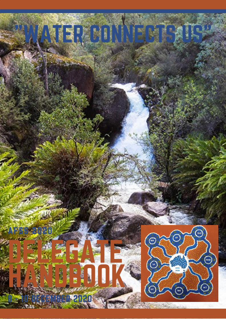
DELEGATEHANDBOOK8 - 10 DECEMBER 2020
AFSS 2020
"WATER CONNECTS US"

SPONSORS
NSW Partner Sponsor
ACT Partner Sponsor
Supporting Sponsor
AFSS 2020 Conference 8 – 10 December 2020 Page 1
Table of Contents
ACKNOWLEDGEMENT OF COUNTRY ................................................................................................................. 2
AFSS 2020 .......................................................................................................................................................... 2
CONFERENCE ORGANISING COMMITTEE .......................................................................................................... 2
CONFERENCE SECRETARIAT ............................................................................................................................... 2
SOCIAL MEDIA ................................................................................................................................................... 2
AWARDS ............................................................................................................................................................ 3
Student Presentation Judging ....................................................................................................................... 3
2020 Apple Prize ............................................................................................................................................ 3
INVITED SPEAKERS ............................................................................................................................................. 4
Lungfish Lecture Invited Speaker .................................................................................................................. 4
2019 Early Career Excellence Award Recipient ............................................................................................. 4
2019 AFSS Hilary Jolly Recipient .................................................................................................................... 4
PROGRAM .......................................................................................................................................................... 5
National Virtual Conference - Pre-recorded Session ..................................................................................... 5
National Virtual Posters ................................................................................................................................. 6
Tuesday, 8th December 2020 – AEDT ........................................................................................................... 7
Wednesday, 9th December 2020 – AEDT ................................................................................................... 10
Thursday, 10th December 2020 – AEDT ...................................................................................................... 12
Local Only Program - New South Wales ...................................................................................................... 13
Local Only Program - Australian Capital Territory ....................................................................................... 14
ABSTRACTS ...................................................................................................................................................... 15
NOTES .............................................................................................................................................................. 41
AFSS 2020 Conference 8 – 10 December 2020 Page 2
ACKNOWLEDGEMENT OF COUNTRY The Australian Freshwater Sciences Society acknowledges the traditional custodians of the land and waters on which society members gather and acknowledges and pays respect to their Elders, past, present and emerging. We honour the past, respect the present and look towards a prosperous and reconciled future.
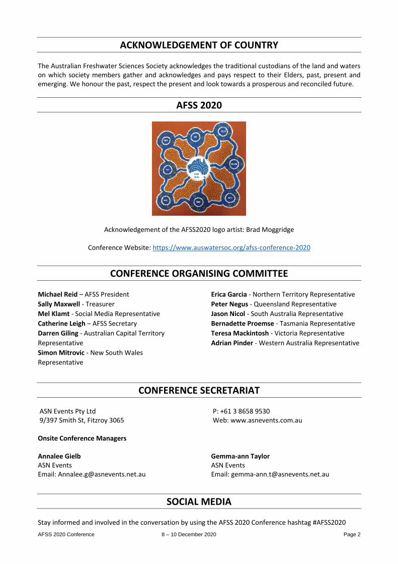
AFSS 2020
Acknowledgement of the AFSS2020 logo artist: Brad Moggridge
Conference Website: https://www.auswatersoc.org/afss-conference-2020
CONFERENCE ORGANISING COMMITTEE Michael Reid – AFSS President
Sally Maxwell - Treasurer
Mel Klamt - Social Media Representative
Catherine Leigh – AFSS Secretary
Darren Giling - Australian Capital Territory
Representative
Simon Mitrovic - New South Wales
Representative
Erica Garcia - Northern Territory Representative
Peter Negus - Queensland Representative
Jason Nicol - South Australia Representative
Bernadette Proemse - Tasmania Representative
Teresa Mackintosh - Victoria Representative
Adrian Pinder - Western Australia Representative
CONFERENCE SECRETARIAT ASN Events Pty Ltd 9/397 Smith St, Fitzroy 3065
P: +61 3 8658 9530 Web: www.asnevents.com.au
Onsite Conference Managers Annalee Gielb ASN Events Email: [email protected]
Gemma-ann Taylor ASN Events Email: [email protected]
SOCIAL MEDIA Stay informed and involved in the conversation by using the AFSS 2020 Conference hashtag #AFSS2020
AFSS 2020 Conference 8 – 10 December 2020 Page 3
AWARDS STUDENT PRESENTATION JUDGING
There is an award for best Undergraduate / Honours student presentation and another for a Masters / PhD student presentation at this year’s conference. The attached link is to a google forms score sheet for student presentations at the AFSS 2020 conference. The presentations available for scoring are listed on the online program. If you would like to contribute to scoring of students presentations please follow the link and do your thing. Each student is scored separately so please enter their name and score the categories listed. To score a different presentation please follow the link again or follow the “submit another response” once a form has been submitted. The deadline for entering scores will be Friday 11th December (the day after the conference is completed). Winners will be announced and awards presented at a later date. Link to scoring survey: https://docs.google.com/forms/d/e/1FAIpQLSf_oEc51ZMerDVOGanR6o5JSyvdPCZmmwy_6eIosO4jMcjaGg/viewform?usp=sf_link
2020 APPLE PRIZE
The Apple Prize is awarded by the students to the Best Presentation by a non-student at the conference. So students, don’t forget to get together before the end of the conference to decide collectively on this year’s winner. Please email the winner’s name to the AFSS secretary Cath Leigh by Monday 14th December: [email protected]
AFSS 2020 Conference 8 – 10 December 2020 Page 4
INVITED SPEAKERS
LUNGFISH LECTURE INVITED SPEAKER
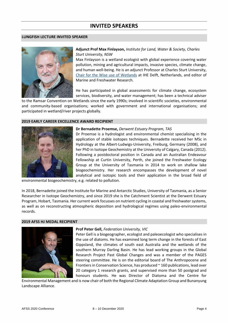
Adjunct Prof Max Finlayson, Institute for Land, Water & Society, Charles Sturt University, NSW Max Finlayson is a wetland ecologist with global experience covering water pollution, mining and agricultural impacts, invasive species, climate change, and human well-being. He is an adjunct Professor at Charles Sturt University, Chair for the Wise use of Wetlands at IHE Delft, Netherlands, and editor of Marine and Freshwater Research. He has participated in global assessments for climate change, ecosystem services, biodiversity, and water management; has been a technical adviser
to the Ramsar Convention on Wetlands since the early 1990s; involved in scientific societies, environmental and community-based organisations; worked with government and international organisations; and participated in wetland/river projects globally. 2019 EARLY CAREER EXCELLENCE AWARD RECIPIENT
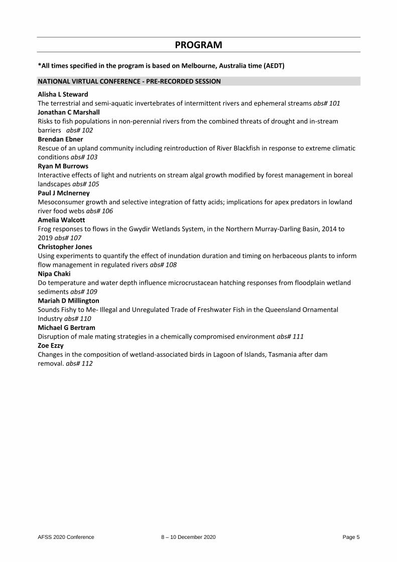
Dr Bernadette Proemse, Derwent Estuary Program, TAS Dr Proemse is a hydrologist and environmental chemist specialising in the application of stable isotopes techniques. Bernadette received her MSc in Hydrology at the Albert-Ludwigs-University, Freiburg, Germany (2008), and her PhD in Isotope Geochemistry at the University of Calgary, Canada (2012). Following a postdoctoral position in Canada and an Australian Endeavour Fellowship at Curtin University, Perth, she joined the Freshwater Ecology Group at the University of Tasmania in 2014 to work on shallow lake biogeochemistry. Her research encompasses the development of novel analytical and isotopic tools and their application in the broad field of
environmental biogeochemistry, e.g. related to pollution. In 2018, Bernadette joined the Institute for Marine and Antarctic Studies, University of Tasmania, as a Senior Researcher in Isotope Geochemistry, and since 2019 she is the Catchment Scientist at the Derwent Estuary Program, Hobart, Tasmania. Her current work focusses on nutrient cycling in coastal and freshwater systems, as well as on reconstructing atmospheric deposition and hydrological regimes using paleo-environmental records. 2019 AFSS HJ MEDAL RECIPIENT
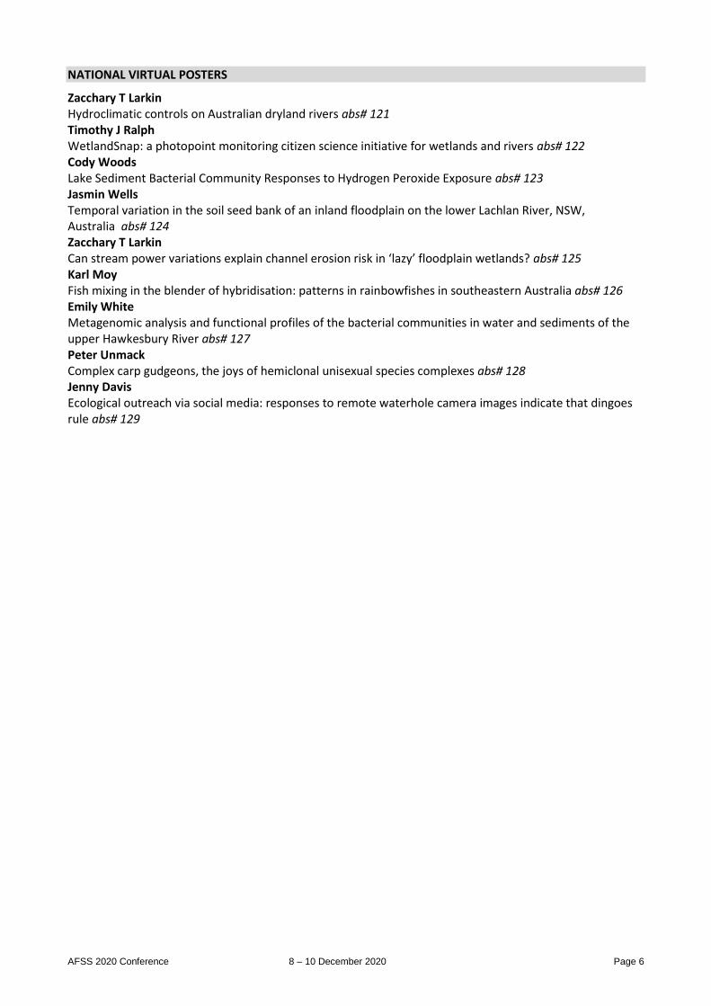
Prof Peter Gell, Federation University, VIC Peter Gell is a biogeographer, ecologist and paleoecologist who specialises in the use of diatoms. He has examined long term change in the forests of East Gippsland, the climates of south east Australia and the wetlands of the southern Murray Darling Basin. He has lead working groups in the Global Research Project Past Global Changes and was a member of the PAGES steering committee. He is on the editorial board of The Anthropocene and Frontiers in Conservation Science, has produced ~ 160 publications, lead over 20 category 1 research grants, and supervised more than 50 postgrad and honours students. He was Director of Diatoma and the Centre for
Environmental Management and is now chair of both the Regional Climate Adaptation Group and Bunanyung Landscape Alliance.
AFSS 2020 Conference 8 – 10 December 2020 Page 5
PROGRAM *All times specified in the program is based on Melbourne, Australia time (AEDT)
NATIONAL VIRTUAL CONFERENCE - PRE-RECORDED SESSION
Alisha L Steward The terrestrial and semi-aquatic invertebrates of intermittent rivers and ephemeral streams abs# 101 Jonathan C Marshall Risks to fish populations in non-perennial rivers from the combined threats of drought and in-stream barriers abs# 102 Brendan Ebner Rescue of an upland community including reintroduction of River Blackfish in response to extreme climatic conditions abs# 103 Ryan M Burrows Interactive effects of light and nutrients on stream algal growth modified by forest management in boreal landscapes abs# 105 Paul J McInerney Mesoconsumer growth and selective integration of fatty acids; implications for apex predators in lowland river food webs abs# 106 Amelia Walcott Frog responses to flows in the Gwydir Wetlands System, in the Northern Murray-Darling Basin, 2014 to 2019 abs# 107 Christopher Jones Using experiments to quantify the effect of inundation duration and timing on herbaceous plants to inform flow management in regulated rivers abs# 108 Nipa Chaki Do temperature and water depth influence microcrustacean hatching responses from floodplain wetland sediments abs# 109 Mariah D Millington Sounds Fishy to Me- Illegal and Unregulated Trade of Freshwater Fish in the Queensland Ornamental Industry abs# 110 Michael G Bertram Disruption of male mating strategies in a chemically compromised environment abs# 111 Zoe Ezzy Changes in the composition of wetland-associated birds in Lagoon of Islands, Tasmania after dam removal. abs# 112
AFSS 2020 Conference 8 – 10 December 2020 Page 6
NATIONAL VIRTUAL POSTERS
Zacchary T Larkin Hydroclimatic controls on Australian dryland rivers abs# 121 Timothy J Ralph WetlandSnap: a photopoint monitoring citizen science initiative for wetlands and rivers abs# 122 Cody Woods Lake Sediment Bacterial Community Responses to Hydrogen Peroxide Exposure abs# 123 Jasmin Wells Temporal variation in the soil seed bank of an inland floodplain on the lower Lachlan River, NSW, Australia abs# 124 Zacchary T Larkin Can stream power variations explain channel erosion risk in ‘lazy’ floodplain wetlands? abs# 125 Karl Moy Fish mixing in the blender of hybridisation: patterns in rainbowfishes in southeastern Australia abs# 126 Emily White Metagenomic analysis and functional profiles of the bacterial communities in water and sediments of the upper Hawkesbury River abs# 127 Peter Unmack Complex carp gudgeons, the joys of hemiclonal unisexual species complexes abs# 128 Jenny Davis Ecological outreach via social media: responses to remote waterhole camera images indicate that dingoes rule abs# 129
AFSS 2020 Conference 8 – 10 December 2020 Page 7
TUESDAY, 8TH DECEMBER 2020 – AEDT
National Welcome to Country and Address 9:45AM - 10:00AM National Live Stream 1 - Australian Capital Territory 10:00AM - 11:15AM Chairs: Darren Giling & William Higgisson 10:00 AM Rodney Ubrihien The role of rainfall in determining nutrient loads and driving cyanobacterial blooms in Lake Tuggeranong abs# 1 10:15 AM Kathryn Vincent First steps in predicting microbial pollution in riverine recreational swimming areas in high and low flow conditions in the Australian Capital Territory (ACT), 2009-2020 abs# 2 10:30 AM Jill Bartlett Opportunities and challenges in water management for a large scale urban development abs# 3 10:45 AM Woo O'Reilly Science Citizen: unanticipated benefits from shifting to a ‘data-first’ approach in a long-term citizen science program abs# 4 11:00 AM James N Hitchcock Microplastics as an emerging threat in aquatic ecosystems abs# 5 Live Stream Break 11:15AM - 11:45AM National Live Stream 2 - Australian Capital Territory 11:45AM - 12:30PM Chairs: Darren Giling & Joanne Bennett 11:45 AM William Higgisson Estimating the cover of Phragmites australis and other wetland features following environmental water using unmanned aerial vehicles and neural networks abs# 6 12:00 PM Klaus Joehnk Water quality impacts of the 2019-20 bushfires in the Upper Murray catchment abs# 7 12:15 PM Matthew Beitzel Cryptic Crayfish in the ACT abs# 8 Live Stream Break 12:30PM - 1:15PM National Live Stream 3 - New South Wales 1:15PM - 2:30PM Chairs: Simon Mitrovic & Michael Reid 1:15 PM Claire Sives Zooplankton heatwave resilience abs# 9 1:30 PM Marita Pearson Is there a link between gully erosion and sedimentation in the waterholes of the Barwon-Darling River? abs# 10 1:45 PM Leah McIntosh Food web structure of the fish community in the Barwon-Darling River abs# 11 2:00 PM Munique C Reid Fish community response to hydrogeomorphic character at multiple spatial and temporal scales abs# 12
AFSS 2020 Conference 8 – 10 December 2020 Page 8
2:15 PM Lorraine Hardwick Insights in aspects of ecosystem productivity in Mulwaree Chain-of Ponds, a rare geomorphic relic abs# 13 Live Stream Break 2:30PM - 3:00PM National Live Stream 4 - New South Wales 3:00PM - 4:15PM Chairs: Michael Reid & Simon Mitrovic 3:00 PM Ellery Johnson Allochthonous subsidies support growth of catadromous fish juveniles abs# 14 3:15 PM Matt Miles Keeping Fish Wet in the Big Dry – Adaptive Management for Environmental Watering in the Mehi River During Severe Drought abs# 15 3:30 PM Simon Mitrovic Tropical macrophytes promote phytoplankton community shifts in lake mesocosms: relevance for lake restoration in warm climates abs# 16 3:45 PM Tsuyoshi Kobayashi Stream metabolism in the Murrumbidgee River abs# 17 4:00 PM Mark R Southwell Wetland lawn – temporal and spatial distribution and controls of lippia, an invasive weed species in the Gwydir Wetlands, Moree NSW. abs# 18 Live Stream Break 4:15PM - 5:00PM National Lungfish Lecture 5:00PM - 5:45PM Chairs: Michael Reid 5:00 PM Max Finlayson A thread of connectivity - meandering through wetland research, conservation practice, community participation, international assessments, policy, and research editing to end up with the rights of wetlands abs# 19 Mixer 5:45PM - 7:00PM Each Hub location will provide a different option for this Mixer. Please reference your hub registration information.
AFSS 2020 Conference 8 – 10 December 2020 Page 9
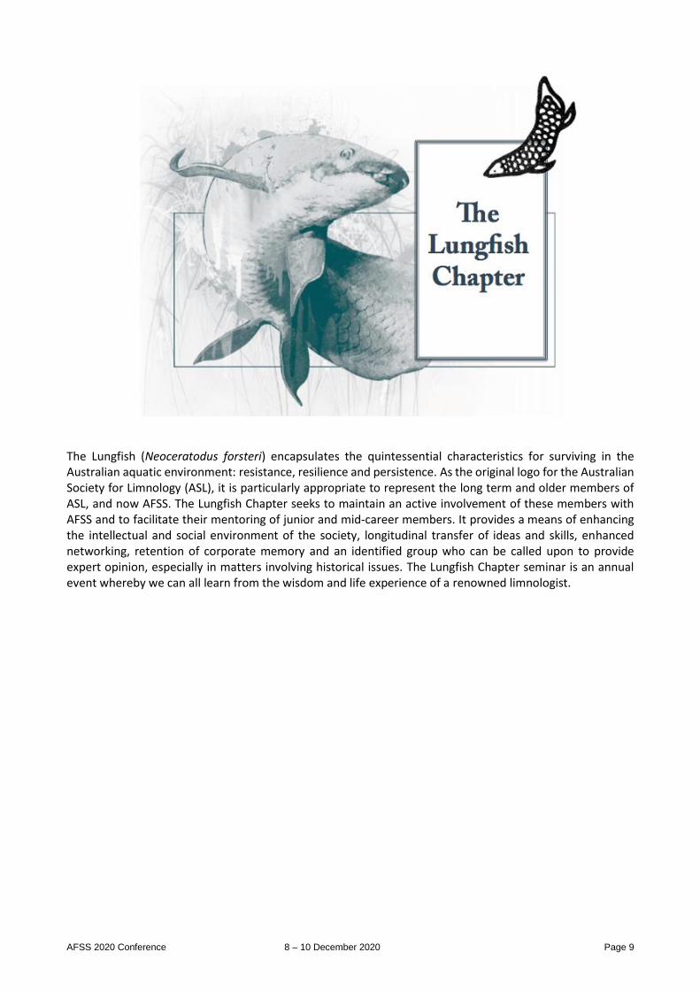
The Lungfish (Neoceratodus forsteri) encapsulates the quintessential characteristics for surviving in the Australian aquatic environment: resistance, resilience and persistence. As the original logo for the Australian Society for Limnology (ASL), it is particularly appropriate to represent the long term and older members of ASL, and now AFSS. The Lungfish Chapter seeks to maintain an active involvement of these members with AFSS and to facilitate their mentoring of junior and mid-career members. It provides a means of enhancing the intellectual and social environment of the society, longitudinal transfer of ideas and skills, enhanced networking, retention of corporate memory and an identified group who can be called upon to provide expert opinion, especially in matters involving historical issues. The Lungfish Chapter seminar is an annual event whereby we can all learn from the wisdom and life experience of a renowned limnologist.
AFSS 2020 Conference 8 – 10 December 2020 Page 10
WEDNESDAY, 9TH DECEMBER 2020 – AEDT
National Live Stream 5 - South Australia 10:00AM - 11:15AM Chairs: Jason Nicol & Sally Maxwell 10:00 AM Julia Short Using diatoms to measure lake response to human activities in Canterbury (NZ). abs# 20 10:15 AM John Tibby Sediment records from World Heritage-listed K'gari/Fraser Island lakes (sub-tropical eastern Australia) highlight their sensitivity to drying abs# 21 10:30 AM Anne E Jensen Environmental Water Requirements are not being Met abs# 22 10:45 AM Jason M Nicol 15 years of vegetation monitoring on the Chowilla Floodplain abs# 23 11:00 AM Anne E Jensen Freshwater Science needs to Speak UP! abs# 24 Live Stream Break 11:15AM - 11:45AM National Live Stream 6 - Western Australia 11:45AM - 1:00PM Chair: Adrian Pinder 11:45 AM Sean T Atkinson How much species diversity can you lose? abs# 25 12:00 PM Holly E. Emery-Butcher Effects of climate and landscape change on endemic freshwater macrocrustacean persistence in south-western Australia. abs# 26 12:15 PM Anthony Santoro Movement strategies of adult female turtles during wet-dry cycling of an urban wetland complex abs# 27 12:30 PM Josephine Hyde Using environmental DNA to conduct monitoring of rakali (Hydromys chrysogaster) in the SW of Western Australia abs# 28 12:45 PM Belinda J Robson How do Australian urban landscapes affect distribution and diversity of Odonata in wetlands? abs# 29 Live Stream Break 1:00PM - 1:30PM National Live Stream 7 - Northern Territory and Tasmania 1:30PM - 2:15PM Chair: Erica Garcia 1:30 PM David N Ikedife Development of downstream passage options for shortfinned eels; the Trevallyn dam downstream eel bypass project abs# 31 1:45 PM Andy AT Taylor Development of flow release rules to mitigate against elevated water temperatures in a northern Tasmanian river system. abs# 32 2:00 PM Bridget E White Stream restoration at a snail's pace? How species traits may influence resistance to restoration efforts. abs# 33

AFSS 2020 Conference 8 – 10 December 2020 Page 11
Live Stream Break 2:15PM - 3:00PM National AGM 3:00PM - 4:00PM National Plenary Session 4:00PM - 5:30PM Chairs: Michael Reid & Catherine Leigh 4:00PM Peter A Gell The end of the past: Facing the new crisis for freshwater biodiversity. abs# 34 4:45PM Bernadette Proemse Water connects us abs# 35
AFSS 2020 Conference 8 – 10 December 2020 Page 12
THURSDAY, 10TH DECEMBER 2020 – AEDT
National Live Stream 8 - Victoria 10:00AM - 11:30AM Chairs: Teresa Mackintosh & Catherine Leigh 10:00 AM Aleicia Holland Temporal and spatial variation in organic matter dynamics in the River Derwent abs# 36 10:15 AM Catherine Leigh DryFlux II: do dry but vegetated inland waters help to offset carbon emissions? abs# 37 10:30 AM Charuni Jayasekara Carbon dynamics and peatland health: can CO2 flux synthesise the complexities of peatland ecosystem function to indicate condition? abs# 38 10:45 AM Chunying Wu Impact of climate change and environmental water delivery on floodplain vegetation: a case study of a connected floodplain-lakes system abs# 39 11:00 AM Edward Tsyrlin Do waterbugs need protection? A case of the wingless Donna Buang stonefly. abs# 40 11:15 AM Teresa Mackintosh Reducing Litter in Melbourne's Waterways abs# 41 Live Stream Break 11:30AM - 12:00PM National Live Stream 9 - Queensland 12:00PM - 12:45PM Chairs: Peter Negus & Alisha Steward 12:00 PM Peter Negus Girt by dirt: Island biogeography and species area relationships of spring wetlands abs# 42 12:15 PM Rebekah Grieger Between a bog and a hard place: a global review of climate change effects on coastal freshwater wetlands abs# 43 12:30 PM Harald Hofmann Aquifer source determination for Brown Lake, Minjerribah, suggests that licensed groundwater extraction is not a contributing cause of falling lake water levels abs# 44 National Closing Remarks 12:45PM - 1:00PM

AFSS 2020 Conference 8 – 10 December 2020 Page 13
LOCAL ONLY PROGRAM - NEW SOUTH WALES
New South Wales Partner Sponsor
Tuesday, 8th December 2020 Local Session - New South Wales 1 12:00PM - 12:45PM Chairs: Lorraine Hardwick & Claire Sives 12:00 PM Rosy Lone Sailing the Ark: Talking crisis communications and dead fish abs# 51 12:15 PM Lisa L Roberts Living Data: Using cultural arts practices to support evidence-based policy abs# 52 12:30 PM Anne Colville Is everyone getting your message? Making scientific communication accessible abs# 53 Wednesday, 9th December 2020 Local Session - New South Wales 2 9:45AM - 11:15AM Chair: Ivor Growns 9:45 AM David Preston Water for the Environment across the NSW Northern Murray Darling Basin Working with Community and Commonwealth to achieve positive outcomes abs# 54 10:00 AM Huy A Luong Confirming the production of BMAA and its isomers by freshwater cyanobacteria and understanding the factors affecting their production by cyanobacterial isolates. abs# 55 10:15 AM Michael A Reid Applying Bayesian Belief Networks to palaeoecological records to improve understanding of floodplain wetland ecosystem change abs# 56 10:30 AM Ivor Growns Effects of inundation on invertebrates in the Gwydir wetlands abs# 57 10:45 AM Brian V Timms Treed Swamps of the Paroo, northwestern NSW --- what drives their diversity and communiality? abs# 58 Local Session - New South Wales - Mock Environmental Court 1:30PM - 2:30PM Thursday, 10th December 2020 New South Wales Excursion - Gwydir Wetlands 12:00PM - 5:00PM
AFSS 2020 Conference 8 – 10 December 2020 Page 14
LOCAL ONLY PROGRAM - AUSTRALIAN CAPITAL TERRITORY
Australian Capital Territory Partner Sponsor
Tuesday, 8th December 2020 Local Welcome and Acknowledgement of Country 9:30am – 9:45am Local Session - Australian Capital Territory 1 3:00PM - 4:15PM Chairs: Darren Giling & Jollene Reich This session will involve discussions with ACT Poster Presenters. Wednesday, 9th December 2020 Local Session - Australian Capital Territory 2 11:45AM - 1:00PM Chairs: James Hitchcock & Rodney Ubrihien 11:45 AM Simon Linke Acoustic monitoring to evaluate environmental watering responses in the Koondrook-Perricoota Forest abs# 61 12:00 PM Joanne M Bennett Identification, characterisation and management of refuge habitat across the Murray-Darling Basin abs# 62 12:15 PM Britt McDonald Applying population models to inform policy and management for the protection of water, wetlands, and waterbirds abs# 63 12:30 PM Darren P Giling Towards upscaling and forecasting the effects of flow on river primary productivity with a mechanistic model abs# 64 12:45 PM Ross Thompson Sustainability, certainty and reconciliation: key challenges for water management in inland Australia. abs# 65 1:00 PM Ben Gawne Overview of the 2020 Evaluation of the Basin Plan abs# 66
AFSS 2020 Conference 8 – 10 December 2020 Page 15
ABSTRACTS
1
The role of rainfall in determining nutrient loads and driving cyanobacterial blooms in Lake Tuggeranong
Rodney Ubrihien1, Fiona Dyer1 1. Centre for Applied Water Science, University of Canberra, Canberra, Australian Capital Territory, Australia
Cyanobacteria blooms are a problem in lakes worldwide. The underlying physical and chemical factors that drive blooms vary. Understanding these factors both broadly and on a lake specific basis is essential to managing blooms. Lake Tuggeranong in the ACT is a man-made lake that provides recreational, aesthetic and environmental benefits to the community. These benefits are affected by regular cyanobacteria blooms.
The period from September 2019 to March 2020 provided a rare opportunity to investigate how rainfall patterns influence the physical and chemical conditions that support cyanobacteria blooms. The period from early November until mid-January was extremely dry, with 2.6 mm of rain falling in 74 days. This contrasts to the period from mid-January to March when there were several large storm events. External nutrient inputs to the lake after mid-January caused large increases to in-lake nutrient loads. This included a doubling and six-fold increase of the of the in-lake total phosphorus and dissolved reactive phosphorus loads respectively. These changes in turn affected the biovolume and community composition of cyanobacteria in the lake. Up until mid-January Aphanocapsa delicatissima was the dominant species of cyanobacteria in the lake. After mid-January there was an increase in cyanobacteria biovolume in the lake and a mixture of heterocyst forming species including Sphaerospermopsis aphanizomenoides, Dolichospermum spiroides, Dolichosprermum planktonicum and Dolichospermum circinale dominated cyanobacteria biovolume in the lake. The changes in the lake demonstrate the importance of rainfall driven external nutrient loads in supporting cyanobacteria blooms in the lake. With future climate forecast predicting greater variability in weather, these findings have implications for future lake management.
2
First steps in predicting microbial pollution in riverine recreational swimming areas in high and low flow conditions in the Australian Capital Territory (ACT), 2009-2020
Kathryn Vincent1, Danswell Starrs1, Aparna Lal1 1. Australian National University, Ainslie, ACT, Australia
Research focus: Predictive water modelling; enterococci concentrations
Student level: Masters (research project)
Australian National University
Recreational swimming sites provide significant social value to users throughout Australia. Water-related gastro-intestinal illnesses are primarily due to recreational use of waterways in Australia. In the ACT, monitoring is undertaken throughout the swimming season (September – April) to test for enterococci coliforms as a bacterial indicator of faecal contamination. In line national recreational water quality guidelines, a result of >200cfu/100ml results in a closure of a swimming area to primary contact recreation.
Using publicly available data, this study examined enterococci levels at public recreational swimming sites across the Murrumbidgee River in the ACT. Statistical analysis focussed on determining if high enterococci concentrations could be predicted with streamflow and water quality.
Our study found a positive correlation between enterococci concentrations and turbidity associated with high flow conditions. The predictive accuracy of the model performed well when testing high enterococci levels during high flow conditions (57%). Prediction of high enterococci levels at low flows were less reliable (14%). As the ACT is expected to experience decreases in rainfall overall but increases in extreme rainfall events due to climate change, understanding the drivers of high enterococci at low flow conditions remains important from a public health perspective. High enterococci concentrations under low flow conditions are not well understood or explained in the literature, suggesting further research is required to explain high enterococci concentrations during low flow conditions.
3
Opportunities and challenges in water management for a large scale urban development
Jill Bartlett1 1. Centre for Applied Water Science, Bruce, ACT, Australia
The Ginninderry development in the ACT is a large scale development that will take up to 30 years and contribute 11,500 houses to the Canberra community. Such a large scale development has recognised impacts on the surrounding environment and waterways. In an effort to manage impacted local waterways, the development has implemented new approaches to managing site runoff and treatment through the installation of high efficiency sediment (HES) basins. The aim of the HES basins is to provide continuous water treatment, facilitate more effective management of site discharge, reduce the volume of chemicals used to treat the water and provide a more reliable water source for recycling on site.
To develop an understanding of the effectiveness of the HES basins on improving water quality of development runoff, the Centre for Applied Water Science (CAWS) has been undertaking frequent monitoring of water quality parameters including nutrients, metals, turbidity, pH and total suspended solids in both the development HES basin and the local stream where the water is discharged.
Stakeholder engagement has been both a key challenge and an opportunity in multiple facets of water quality management at Ginninderry. These facets include ensuring site users understand what water quality parameters represent; understanding the causes of changing water quality parameters onsite and implementing management actions both on the development site and in the downstream conservation corridor. Feedback mechanisms and effective communication have improved water management approaches onsite and resulted in actions that improve water quality outcomes.
AFSS 2020 Conference 8 – 10 December 2020 Page 16
4
Science Citizen: unanticipated benefits from shifting to a ‘data-first’ approach in a long-term citizen science program
Woo O'Reilly1, Danswell Starrs1 1. Environment, Planning and Sustainable Development Directorate, ACT Government, Canberra, ACT, Australia
Citizen science programs can suffer from perceptions of poor data quality, which can impede incidences of data uptake. Upper Murrumbidgee Waterwatch was established in 1995 as part of a national program and represents a typical citizen science program that is overcoming these issues through a ‘data-first’ approach.
In 2013 Waterwatch lost its core funding and was forced to review its purpose, methods and processes. It was believed at the time that Waterwatch data suffered from a lack of confidence from potential users due to a range of real and perceived issues. Thus, the main focus of its review was to increase confidence and uptake of the Waterwatch data by researchers and policy makers in order to help secure funding.
The review included an independent analysis of Waterwatch data from the University of Canberra, an overhaul of the quality control processes, a consolidation of Waterwatch data management systems, plus a standardisation of equipment, instruction manual and training processes. The annual Waterwatch catchment health report card was updated to present results at a finer spatial scale and providing a high-profile communication tool to the funding agencies and community.
The ‘data-first’ approach has enabled Waterwatch to better partition and manage the key areas of the program. Shifting to a more contributory structure, whilst recognising the positive elements that come with community ownership, has supported a shift in focus to be more strategic which has enabled improvements in site placement and data quality control. This has resulted in better data uptake and this in turn has encouraged retention rates for volunteers who can see the data they collect being put to good use.
Waterwatch now receives ongoing funding from the ACT Government and their data features in the local Water Strategy, three government monitoring programs as well as the ACT State of Environment report 2019.
5
Microplastics as an emerging threat in aquatic ecosystems
James N Hitchcock1 1. University of Canberra, Bruce, NSW, Australia
Research into microplastics in aquatic environments has rapidly increased over the last 15 years. We now know microplastics are ubiquitous in aquatic environments and have been reported from the deep ocean trenches, ice in Antarctica, and remote alpine lakes. They can be ingested by a wide range of organisms and toxicology studies have shown they can influence growth, reproduction and survival. Despite these advancements we still lack a range of basic information that can help us predict what anthropogenic and environmental factors are important in predicting microplastic contamination. In this talk I will present results from two studies exploring how microplastic contamination varies in systems with types of landuse and the role of storm events in mobilising microplastics. I will then briefly touch on preliminary work investigating how microplasitcs may be influencing the planktonic community structure.
6
Estimating the cover of Phragmites australis and other wetland features following environmental water using unmanned aerial vehicles and neural networks
William Higgisson1, Adrian Cobb2, Alica Tschierschke1, Fiona Dyer1 1. Univeristy of Canberra, Belconnen, Australian Capital Territory, Australia
2. Private, Company, Canberra
Phragmites australis (common reed) is a widely distributed aquatic perennial grass of ecological and economic value. Declines and dieback in Phragmites australis have been observed in Europe and Australia, while the species has experienced range expansions in North America. The economic and ecological implications of both declines and range expansions has prompted a growing need for regular and accurate data collection to inform management and implement adaptive management strategies effectively.
Understanding the spatial arrangement of plants such as Phragmites australis and other wetland features in response to management actions (such as environmental flows) is an important part of managing freshwater systems such as wetlands. The use of unmanned aerial vehicles (UAV) provide high resolution and detailed imagery. Computational deep learning techniques are transforming the way in which these remotely sensed imagery and data can be used and are having an increasing role in remote sensing.
This study describes a novel image analysis technique using UAV and machine learning known as Convolutional Neural Networks for mapping the cover and extent of features of an ephemeral Phragmites australis reedbed in the Great Cumbung Swamp, on the Lachlan River, NSW. We trained our model to recognise five wetland features (Phragmites australis, bareground, leaf-litter, water and other vegetation) using point cloud imagery of five 50 X 50 m plots. The model was then validated using imagery which was previously unseen. The validation process demonstrated an overall high accuracy (0.90) and high precision (0.92) and could correctly identify Phagmites australis to 98% accuracy.
Using the model, we compared nine sites across three environmental watering frequencies in late January 2020. Sites which received two environmental waters in the past 12 months had the greatest cover of Phragmites australis, followed by sites which received one. Sites which had not received environmental water in the past 12 months had significantly lower cover of Phragmites australis.
AFSS 2020 Conference 8 – 10 December 2020 Page 17
7
Water quality impacts of the 2019-20 bushfires in the Upper Murray catchment
Klaus Joehnk1, Tapas Biswas1, Anu Kumar2, Fazlul Karim1, Scott Wilkinson1, Juan Guerschman1, Gavin Rees3, Paul McInerney3, Petter Nyman4 1. CSIRO, Canberra
2. CSIRO, Adelaide
3. CSIRO, Albury
4. Alluvium Consulting, Cremorne
The ‘Black Summer’ bushfires of 2019/20 burnt significant portions of agricultural and forested land in the upper Murray River catchment in south-east Australia. CSIRO undertook a pilot study in the main channel of the Murray River during and after the bushfires to assess impacts on aquatic ecosystems and to explore potential solutions for both short- and long-term deterioration of water quality. Heavy rainfall events immediately after fires in severeley burnt catchments produced large increases in sediment loads and increased the concentration of pollutants (ash, nutrients, organics and metals) that degraded local water quality and threatened water quality in downstream Lake Hume. Short-term effects were readily visible by the black colour and the media reported “cake-mix” viscosity of the water and localised fish kills. Medium to long-term impacts are less clear and require continued monitoring across extended temporal and spatial scales.
Here, we present a synthesis of our key findings from our pilot study, focussing on fire severity maps, changes in streamflow, sediment and nutrient loads, water quality and ecotoxicity responses. Information generated from this study provides a valuable basis for future research direction to support bushfire-related research effort and policy development in catchments across Australia.
8
Cryptic Crayfish in the ACT
Matthew Beitzel1, Mark Jekabsons1, Lisa Evans1 1. ACT Government, Canberra, ACT, Australia
The ACT has two species of medium sized montane Euastacus Spiny Crayfish; Alpine Crayfish (Euastacus crassus) and Riek’s Crayfish (Euastacus rieki). Spiny Crayfish are slow growing, taking many years to mature. Both these species occur above 600 m A.S.L. and have maximum temperature tolerances between 16 and 21oC (McCormack 2012). They occur in both creeks and bog and fens which are locally and nationally listed threatened community with E. rieki tends to occur at higher altitudes and lower temperature.
The ACT Government has been working to understand the distribution and status of these species as they are considered to be at risk of climate change, fire, habitat destruction and pest animal impacts. Pilot studies were undertaken in the two major habitat types to determine the most efficient survey methods, compared daytime, and overnight bait trapping, spotlighting and backpack electrofishing. Tank trials were also undertaken to establish bait choice and examine escapism from bait traps. Distribution maps of the crayfish for the ACT were developed from additional surveys, historic and opportunistically collected records. These are helping guide actions following the 2020 Orroral Valley Fires which impacted approximately 90 % of the distribution of E. rieki, burning both bog and creek habitat and resulting in high predation by foxes particularly bog habitat where vegetation cover has been removed.
9
Zooplankton heatwave resilience
Claire Sives1 1. UNSW, Ashfield, NSW, Australia
An ode to zooplankton heatwave resilience
In the dried sediments of empty dryland lakes,
zooplankton egg banks lay waiting under the hot sun.
After months or years, lakes fill and dormancy breaks,
zooplankton hatch and emerge many, all, or some.
Under climate change their resilience may be tested,
dryland temperatures to increase more than the global mean.
Zooplankton survival could be impacted or arrested,
will they survive this ecological extreme?
To understand the impacts of heatwaves on hatching,
current conditions should be known and relative.
Are the temperatures of ground and air matching?
These were measured to make research representative.
Climate change projections were added to the new data,
creating heatwave treatments to mimic extremes.
Lake sediments were “cooked” for a starter,
then water added, zooplankton hatchlings counted once seen.
The zooplankton triumphed, their survival is protected,
hatching after 66°C heatwaves an amazing feat, and discovery.
AFSS 2020 Conference 8 – 10 December 2020 Page 18
Climate change impacts currently projected,
are within zooplankton mechanisms of resilience and recovery.
10
Is there a link between gully erosion and sedimentation in the waterholes of the Barwon-Darling River?
Marita Pearson1, Michael Reid1, Darren Ryder1, Cara Miller1 1. University of New England, Dubbo, NSW, Australia
Waterholes or deep pools capable of retaining water in the absence of flow are a critical feature of dryland rivers, which are increasingly being threatened by accelerated rates of sedimentation. Sedimentation causes the infilling of waterholes leading to a decline in geomorphic complexity, habitat quality and waterhole persistence. In dryland rivers the source of sediment is often not well understood and is often assumed to come from upstream sources at some distance to the waterholes of concern. To address this assumption, this study quantifies the frequency of alluvial gully erosion and the magnitude of gully derived sediment contributing from the adjacent floodplain to a dryland river in south-east Australia. Alluvial gullies along the Barwon-Darling River were observed at 3-4 gullies per kilometre, with a median gully volume of 3873 m3. The number of gullies has increased on average by 44 % since the late 1960s, which is attributed to the hydrological influence of low-level weirs. The volume of gully derived sediment contributed to the river also appears to be linked to these large, static weir pools. However, more work is required to investigate the combination of factors driving gully expansion and to determine if these factors vary from those driving gully formation. A predictable relationship was not observed between sediment contribution and change in waterhole depth. Instead, the distance of a waterhole from its closest upstream tributary had a greater influence on changing waterhole depths. However, it is suggested that the processes driving sedimentation are operating at a spatial and temporal scale larger than explored in this study. Consequently, the depth of present-day waterholes may have been impacted by sedimentation, but its effect may be masked by alternative sources of sediment, artificially high-water levels created by low-level weirs or by a spatial and temporal lag between sediment delivery and deposition.
11
Food web structure of the fish community in the Barwon-Darling River
Leah McIntosh1, Michael Reid1 1. University of New England, Armidale, NSW, Australia
Water resource development to meet human water needs has altered the natural variability of river flow regimes. The Barwon-Darling River is a dryland river characterized by extreme hydrological variability, which has experienced a change in hydrology and geomorphology since European settlement. We investigated the fish-centered food web structure in six sites in the main river channel to determine if varying levels of hydrological connectivity influenced trophic interactions. Samples were collected in March 2019 during a period of no flows when the river had receded into a series of disconnected waterholes. Analysis was restricted to four species that were caught in high enough abundance at all sites. Stable isotopes (δ13C and δ15N) were used to determine consumer trophic position and community metrics. There were high levels omnivory at all sites and indications of spatial variation with some sites showing more trophic overlap. However, no consistent pattern was found between food web structure and classifications of hydrological character. Due to the extended no-flow period, local habitat characteristics likely had a larger influence on food web structure than antecedent hydrology. Explaining spatial variation among sites likely requires a more thorough assessment of food web structure and site variables than this study allowed.
12
Fish community response to hydrogeomorphic character at multiple spatial and temporal scales
Munique C Reid1, Cara Miller1, Michael A Reid1, Ross Thompson2 1. University of New England, Armidale, NSW, Australia
2. Institute for Applied Ecology, University of Canberra, Canberra, ACT, Australia
Hydrology has long been considered the main driver of fish communities. The combined influences of hydrology and geomorphology on community dynamics has received less attention, particularly in relation to these interactions at multiple spatial and temporal scales. The studies that tackle the relationship between ecosystem components, and both hydrology and geomorphology, have conflicting views about which specific hydro-geomorphic features are key to producing the habitat mosaic that exists in riverine landscape and how these features drive ecosystem responses.
Several hydrogeomorphic variables representing two spatial (10s m to 10s km) and two temporal (inter-annual to decadal) scales have been identified as the main contributors to the heterogeneous character of the Upper Mississippi River-floodplain. This study aims to test if these same variables explain variation in fish community structure among eighteen backwater and island lake habitats representing a gradient of hydrological connectivity and ecosystem size.
Since riverine landscapes are hierarchical in the way they function and most ecological processes are scale dependent, we hypothesize that larger scale features such as long-term hydrology variables (e.g. decadal connectivity) and landscape-scale characteristics (e.g. position in the landscape) will influence variation in higher levels of ecological organisation such as species persistence. Whereas smaller scale features such a short-term connectivity (e.g. duration of a connection event) and patch-scale characteristics (e.g. water depth) will influence lower levels of ecological organisation such as community structure and population size-class distribution in these habitats.
AFSS 2020 Conference 8 – 10 December 2020 Page 19
13
Insights in aspects of ecosystem productivity in Mulwaree Chain-of Ponds, a rare geomorphic relic
Lorraine Hardwick1, 2, Grant Hose2, Kirstie Fryirs3 1. Charles Sturt University, Albury, NSW, Australia
2. Department of Biological Science, Macquarie University, Balaclava Rd, North Ryde, NSW, Australia
3. Department of Environmental Science, Macquarie University, Balaclava Rd, North Ryde, NSW
Mulwaree Chain of Ponds is a geomorphically rare aquatic system in eastern Australia. Apparently stable and in a highly altered agricultural setting, these ponds are uncharacteristic of local river systems. The deep, large ponds are connected by shallow, vegetated and discontinuous preferential flow paths. Margins of the ponds are vegetated by aquatic, mostly rhizomatous or stoloniferous plants, including Cycnogeton procera, Vallisneria gigantea, Phragmites australis and Eleocharis sphacelata. Once flow is disconnected during summer, these ponds become strongly stratified related to dissolved oxygen, temperature and electrical conductivity; and with a euphotic depth (z1%) of up to 6 metres. This unusual ecosystem provided an opportunity to investigate some of the functional processes driving production, respiration and decomposition during connected and disconnected flow periods. Use of light and dark bottles, combined with phytoplankton methods and C. procera leaf decomposition, has enabled initial understanding of the ecology of this rare system. Light and dark bottles were incubated insitu at depths mid-pond and at three points in the vegetated margins for 24 hours to investigate community production, with chlorophyll A, nutrients and water quality also measured. The results suggested that these chain of ponds act as small monomictic lakes, with seasonal stratification as flows cease. Leaf litter bags with mesh size 9 mm and 150 micron and cotton strips were used to measure total, microbial and standardised decomposition respectively over 21-28 days, mid-pond and within the vegetated margins. Maximum mean gross production at the pond surface (562 mg/m3/d), during mid-summer, significantly declined below the oxycline (30 mg/m3/d) during disconnection. These patterns were not reliably matched by chlorophyll A levels at the same sample points. Total to microbial leaf litter decomposition was strongly seasonal and dominated by microbes. Additionally, small individual pond effects such as cattle grazing and recreational activities altered pond dynamics.
14
Allochthonous subsidies support growth of catadromous fish juveniles
Ellery Johnson1, Craig Boys1, Unnikrishnan Kuzhiumparambil1, Stewart Fielder1, Simon Mitrovic1 1. UTS, Broadway, NSW, Australia
Fresh water inflows have long been linked to secondary productivity and fishery catch rates in estuaries. While inputs of allochthonous nutrients are purported to increase primary production and subsequently secondary production, the role of allochthonous carbon in this process is still debated. We performed an experimental mesocosm study where the effects of varying levels of dissolved organic carbon (DOC) additions to the diet of juvenile Australian bass (Maquaria novemeculata) were investigated. Artemia sp. nauplii were on grown in mesocosms with additional concentrations of either 5mg or 10mg of DOC for 2 days. DOC additions were administered through a naturally derived allochthonous leachate (.45µm filtered, from Casuarina glauca and Eucalyptus sp.). Artemia sp., bio encapsulating the carbon leachate as well as subsequent bacterial communities, were then fed to juvenile bass in their treatment microcosms over 42 days. Juvenile fish in the 5mg treatment exhibited no statistical difference for weight, standard length, fork length or total length compared to the control. However, fish in the 10 mg treatment had significant increases in all length parameters after 28 days as compared to other treatments and were significantly different in weight by 42 days. Changes in delta-13C of fish in the 10mg treatment indicated assimilation of terrestrially derived material and changes in delta-15N indicated nauplii in this treatment were of higher nutritional quality than other treatments. We conclude that additions of allochthonous material to estuaries by inflows may have the ability to influence the growth rates, and potentially recruitment, of juvenile Australian bass. This may have implications for inflow and fisheries management when considering the timing of environmental releases.
15
Keeping Fish Wet in the Big Dry – Adaptive Management for Environmental Watering in the Mehi River During Severe Drought
Matt Miles1, Daryl Albertson1, David Preston1 1. Environmental Water and Floodplains team, Armidale, NSW, Australia
Late 2019, the Northern Basin was in a state of severe drought. Mehi River had ceased to flow for over 100 days, prompting the DPlE – Biodiversity & Conservation Division and the Commonwealth Environmental Water Office, to collaborate on a delivery of water for the environment. NSW and Commonwealth accounts were utilised to sustain critical refuge pool habitat for fish and other aquatic fauna in the Mehi.
Inherent risks exist during such deliveries, including the formation of hypoxic blackwater. Despite the risks, one thing was known with certainty, if flows did not occur to replenish refuge pools, there would likely be a total loss of native fish in the Mehi.
The delivery was made from Tareelaroi Weir and replenished refuge pools. Water quality issues were observed upstream of Moree, where blackwater formed due to organic matter accumulation. A small number of fish mortalities were recorded. A more significant blackwater event occurred downstream at Combadello Regulator where approximately 200 native fish died.
During the early stages of the delivery, an interagency group formed to respond to potential water quality issues. The group identified the significant risk of a further large fish kill downstream at Gundare Regulator, the last refuge pool in Mehi River before Barwon River. The group developed three response actions to attempt to address the event; the upstream flow rate was raised to improve downstream water quality, a portion (100 ML) of the blackwater was removed via an irrigation pump and weir pool manipulation was used at Gundare Regulator to direct blackwater down the dry Mallowa Creek.
These actions proved successful and were important for promoting recovery of native fish in Mehi River. As a result of lessons learnt, we now have a suite of new tools for restarting dry rivers and managing environmental water deliveries during severe droughts.
AFSS 2020 Conference 8 – 10 December 2020 Page 20
16
Tropical macrophytes promote phytoplankton community shifts in lake mesocosms: relevance for lake restoration in warm climates
Darren Sim1, Simon Mitrovic2, Maxine Mowe1, Hugh Tan1, Daniel Roelke3, Darren Yeo1 1. National University of Singapore, Singapore
2. University of Technology, Sydney, Broadway, NSW, Australia
3. Texas A+M University, Texas, USA
Macrophytes are crucial for maintaining clear water conditions in temperate shallow lakes. However, the role of macrophytes in regulating phytoplankton in tropical lakes, which experience distinct ecological processes, and their restorative potential remains uncertain. We investigated the effects of emergent (Ludwigia adscendens and Persicaria barbata) and submerged (Vallisneria spiralis) macrophytes on the phytoplankton community of a turbid tropical reservoir. Through two in-situ, four-week, mesocosm experiments, we (1) determined the effects of macrophyte density on phytoplankton biomass and composition, and (2) compared these effects between emergent and submerged macrophytes. In Experiment 1, macrophyte treatments reduced phytoplankton biomass and increased water clarity in a density-dependent manner. Only the higher density treatment (300/650 g fresh biomass) altered the taxonomic composition, favoring green algae and cryptophytes while suppressing cyanobacteria. In Experiment 2, emergent and submerged macrophytes both incrementally reduced phytoplankton biomass but shifted phytoplankton compositions away from cyanobacterial dominance in a turbid tropical reservoir. Our results indicate the potential for different macrophyte growth-forms to reduce phytoplankton biomass and influence phytoplankton community composition away from cyanobacterial dominance in a turbid tropical reservoir. This has potential applications for managing other lakes and reservoirs in tropical climates.
17
Stream metabolism in the Murrumbidgee River
Tsuyoshi Kobayashi1, 2, Benjamin J Wolfenden2, 3 1. Science, Economics and Insights Division, Department of Planning, Industry and Environment, Lidcombe, NSW
2. Institute for Land, Water and Society, Charles Sturt University, Albury, NSW
3. Regional Operations Group (South Branch), Department of Planning, Industry and Environment, Albury, NSW
We investigated stream metabolism in the Murrumbidgee River in relation to delivery of environmental water under the Commonwealth Environmental Water Office (CEWO) Long–Term Intervention Monitoring (LTIM) project (2014-19). An open‐system, single-station diurnal oxygen change method was used to determine the daily rates of gross primary productivity (GPP) and ecosystem respiration (ER) at two in-channel sites (Narrandera and Carrathool) between spring and autumn. The two in-channel sites were more than 100 kilometres apart and in reaches with contrasting hydrology due to flow extraction and diversions. Overall, the GPP rate varied in the range 0.03-13.58 mg O2 L
-1d-1 and the ER rate in the range 0.06-26.82 mg O2 L-1d-1 (n=1382). A bivariate plot of the annual median GPP:ER ratios against the
annual median flow rates (n=5) showed a site-specific negative relationship between them. The stream metabolism response to river flows seems to be complex. Site-specific factors may play an important role in regulating the GPP, ER and their ratio in the Murrumbidgee River.
18
Wetland lawn – temporal and spatial distribution and controls of lippia, an invasive weed species in the Gwydir Wetlands, Moree NSW.
Mark R Southwell1, Ben E Vincent1, David Preston2, Jane Humphries3 1. University of New England, Armidale, NSW, Australia
2. Environment Energy and Science, NSW Planning Industry and Environment, Moree, NSW, Australia
3. Commonwealth Environmental Water Office, Department of Agriculture, Water and the Environment, Moree, NSW, Australia
Lippia (Phyla canescens) an introduced plant, is now a pastoral weed that has spread through large parts of the Murray-Darling Basin severely degrading both the environmental and economic integrity of the system. Lippia’s prostrate growth form, extensive root system, multiple recruitment methods (seeds, plant segments and rhizomes), low palatability and fast growth rate provide it with a competitive edge, resulting in reduced biodiversity where it occurs. In wetland systems, inundation history plays a central role in the distribution of Lippia, both through suppression of growth in areas of sufficient depth and duration of inundation, and promoting the growth of native species such as Water Couch (Paspalum distichum), that can outcompete lippia. Vegetation monitoring over 6 years in the Gwydir Wetland system near Moree in northern NSW has allowed us to assess changes in the distribution of lippia within study plots, and the potential drivers of these changes. Lippia was present in 90% of survey plots across the 6 years of monitoring and was more prominent in vegetation communities higher in the landscape, especially within Coolibah Woodland sites. Lippia tended to be more prominent across the landscape during drier periods, except during spring 2019 following severe drought when it was at very low abundance. In line with this, time since inundation was shown to be a dominant factor influencing the cover of lippia, with deeper inundation and sufficient length of inundation later in and over spring/summer supressing growth and advantaging other wetland species. Overall, our observations support the literature, showing that wetland inundation is an important tool for managing lippia in this wetland system.
AFSS 2020 Conference 8 – 10 December 2020 Page 21
19
A thread of connectivity - meandering through wetland research, conservation practice, community participation, international assessments, policy, and research editing to end up with the rights of wetlands
Max Finlayson1 1. Charles Sturt University, ALBURY, NSW, Australia
The opportunity to talk about a journey through a mix of wetland-scapes and seemingly disjunct disciplines may not excite everyone. And there is absolutely no reason it should. In my case I find it exciting and it builds from some influential statements which helped shape my meandering and connections. One was being instructed to do mission-orientated research. Another was hearing that we did not need to wait to manage wetlands while academics did yet more research. Being told by a bureaucrat that as a wetland scientist I should not be talking about climate change and wetlands. Also hearing (more than once) that they (the experts) did not listen to community members beyond taking local knowledge and publishing it. And another bureaucrat telling me that researchers should keep out of policy. As I collected and collated information that showed wetlands, their species, and their ecosystem services were in decline globally I reflected more and more on such statements.
As I meandered I noticed a few other things, including that many hard working practitioners seemed to be out of touch with current knowledge – some seemed stuck with whatever they recalled from their undergraduate days. Further, international processes and assessments simply came and went with a lack of influence on the ground. But also realising that international policy could drive national policy and local outcomes, not directly, but surreptitiously and with time. Yet with time the very things we valued were declining. Advocacy by scientists seemed to be frowned on. Science was key, but not all science is that great – check the rejection rates of journals, and ponder the vagaries of peer review. Our practitioners don’t have time to follow the endless stream of academic papers, nor have time to write papers, as they need to manage. Yet don’t they need better and more knowledge, and the rest of us would benefit by knowing what they have learnt? And our wetland-scapes are still in decline.
And at that stage we come to a hairpin bend, not just a gentle meander. Especially as all of the above is true. And we haven’t yet gotten into the need for social understanding. Unfortunately, reversing the trends for our wetland-scapes is not simple, as I am sure we all realise. Many factors intercede. The ones that I can report on across wetland research, conservation practice, community participation, international assessments, policy, and research editing are but some of what are needed. The purpose of these, in my opinion, is to ensure that wetland advocacy is alive and well and contributing to policy and to practice. We need advocacy – the data tells us that. We should ask ourselves if past practice and policy has succeeded, and will the current iterations? For myself, sharing knowledge is paramount to having better policy and practice, but it’s too slow – we also need advocacy, and it comes in many forms, including through our staid journal writings. And my current advocacy is for the rights of wetlands.
20
Using diatoms to measure lake response to human activities in Canterbury (NZ).
Julia Short1, John Tibby1, Marcus Vandergoes2, Susie Wood3, Xun Li2 1. The University of Adelaide, Adelaide, SA, Australia
2. The Institute of Geological and Nuclear Sciences, Lower Hutt, New Zealand
3. Cawthron Institute, Nelson, New Zealand
Humans first settled in New Zealand ~800 years ago and arrived in a landscape where natural disturbances were driven by volcanoes and earthquakes. Following Māori settlement, New Zealand’s landscape was heavily deforested, while European arrival saw further degradation of the landscape and freshwater ecosystems. Today, freshwater ecosystems in New Zealand are threatened by myriad of stress, while still being of high cultural and environmental importance. In the Canterbury high country on the South Island, dense forest was converted to tussock grassland, which still remains. This region has numerous lakes, created by the retreat of glaciers at the end of the last ice age. The lakes in the region are considered to be pristine, by visitors and locals alike. It is through the study of lake sediments, palaeolimnology, that ‘reference’ conditions and the effects of human disturbances upon lake systems, can be identified. Palaeolimnological methods using diatoms (single-celled algae) species and their relative abundance, were counted at high resolution in sediment cores from five lakes (Heron, Pearson, Emma, Emily and Clearwater) in a similar regional setting. From these records in combination with pollen data, we were able to reconstruct past lake ecology, and their respective responses to successive landscape transformations. Preliminary results suggest a differential response between the lakes, such as the increasing abundance of planktonic diatom species, despite the similar timing of deforestation and agricultural events. Currently, one species (Discostella stelligera) is of particular interest and its potential as an indicator for Māori landscape disturbance is being explored. This study will also contribute to understanding how lakes can differ in their response to landscape clearance, while being in a similar geographical setting.
21
Sediment records from World Heritage-listed K'gari/Fraser Island lakes (sub-tropical eastern Australia) highlight their sensitivity to drying
John Tibby1, Haidee Cadd2, Cameron Barr1, Francesca McInerney1, Jonathan Tyler1, Jonathan Marshall3, Glenn McGregor3, Patricia Gadd4, Clare Murphy1, Matt Raven1 1. University of Adelaide, Adelaide, SA, Australia
2. University of New South Wales, Sydney, NSW, Australia
3. Department of Environment and Science, Queensland Government, Brisbane, QLD, Australia
4. Australian Nuclear Science and Technology Organisation, Lucas Heights, NSW, Australia
Lakes are some of the most biodiverse, yet vulnerable, ecosystems on the planet. K'gari or Fraser Island, the largest sand island in the world, has a large number of permanent lakes and represents one of the few true lake districts on the Australia mainland. The lakes of K'gari/Fraser island are both beautiful and remarkable because many are perched above the regional water table where an impermeable layer separates them from the sand below. These lakes are one of the reasons why the island is listed as a UNESCO World Heritage site. Understanding the history of these lakes and their response to past climate variability is likely to provide insights into their future vulnerability to climate change.
AFSS 2020 Conference 8 – 10 December 2020 Page 22
Holocene (i.e. post “ice age”) sediment records have now been analysed from six lakes on K'gari/Fraser Island. There was marked aridity on the island from c. 8000 to 5500 years ago with some lakes drying completely. Interestingly, at some sites there is little to no physical evidence of drying which is instead recorded as a hiatus in the accumulation of highly organic, acidic, lake sediments.
The mid-Holocene dry phase recorded on K'gari/Fraser Island contrasts with evidence from perched lakes on North Stradbroke Island, a sand island approximately 150 km to the south. As a result, there is strong potential to infer the Holocene regional climatology of the Australian subtropics at small spatial scales from these records.
These results highlight a largely unrecognised vulnerability of lakes on K’gari to drying and indicates a need to better understand perched lake hydrology and response to projected future climate change.
22
Environmental Water Requirements are not being Met
Anne E Jensen1 1. Anne E Jensen Environmental Consultant, LEABROOK, SA, AUSTRALIA
Extensive effort since the early 1990s has developed environmental water requirements (EWRs) for Australian river ecosystems. Site watering plans have been prepared and annual priorities for environmental watering are determined in the Murray-Darling Basin.
Are the EWRs being met? Success stories include coordinated flows across multiple catchments that provide environmental benefits along river systems and capture return flows for use downstream. Key habitats which have benefited from coordinated flows include the Gwydir and Macquarie Rivers, Barmah-MIllewa forest, Pericoota-Gunbower forest, Hattah Lakes, the Lower Murray and the Coorong.
However, the focus of water delivery is still on selected sites and reaches, with whole sections of floodplains missing out. Walker and Thoms (1993) predicted that Murray floodplains would be reduced to one-third of their natural areas under projected flows. Sadly, this seems to be coming true in the Lower Murray.
No water has reached the outer floodplain communities in the Lower Murray since the 1970s. Monitoring results from 30 watered sites at 9 locations suggest that there has not been enough environmental water to meet EWRs.
We know what is needed for healthy floodplains. However, bureaucratic processes are limiting the effectiveness of environmental water. Once there is an approved process for annual prioritisation for sites with watering plans, water should be allocated to regions for local management, with sufficient volumes to ensure minimum water requirements are met.
In 2020, river red gums and black box on the Lower Murray floodplain are in their fifth year without over-bank flooding, a known critical trigger for stress in river red gums. Mature trees have gone into physiological hibernation, conserving water resources and reducing crop cycles and volumes. It is likely that almost all sites will need watering in 2021-22, which will severely test environmental water delivery capacity, not to mention the approvals process!
1. Walker, K.F. & Thoms, M.C. (1993). Environmental effects of flow regulation on the Lower River Murray, Australia. Regulated Rivers: Research & Management, 8, 103-119.
23
15 years of vegetation monitoring on the Chowilla Floodplain
Jason M Nicol1 1. SARDI Aquatic Sciences, Henley Beach, SA, Australia
The Living Murray Program has resulted in medium to long-term monitoring datasets being collected at numerous sites throughout the Murray-Darling Basin. The floodplain understorey vegetation at the Chowilla TLM Icon site, on the border of South Australia, Victoria and New South Wales, has been monitored annually since 2006. During the condition monitoring program the Chowilla Floodplain experienced the worst drought in living memory with the longest recorded period with no over bank flows, two watering interventions, two over bank floods, numerous smaller flow pulses, the construction and operation of the Chowilla Environmental Regulator and implementation of the Murray-Darling Basin Plan. Monitoring has shown understorey vegetation is resilient and responded to watering prior to the 2010 flood and over bank flooding with recruitment of amphibious and floodplain species. The response is typically short-lived, with terrestrial vegetation establishing within two years of inundation; however, this is expected as most floodplain species are annuals or short-lived perennials. The response to regulator operation has been muted, probably due to grazing by native vertebrates, which have increased in numbers since the 2010-11 flood. Despite the good temporal data sets relating to changes in vegetation patterns, the processes that influence the patterns are less well understood and their function is even less well understood.
24
Freshwater Science needs to Speak UP!
Anne E Jensen1 1. Anne E Jensen Environmental Consultant, LEABROOK, SA, AUSTRALIA
Freshwater science has blossomed over the last 40 years, building collective wisdom which has sadly not been able to ensure that rivers and wetlands are managed more sustainably. Why is that?
The late Keith Walker wrote an article entitled ‘Death of the Murray’ back in 1983. Over many years Keith consistently urged the need to mitigate the effects of river regulation and to maintain healthy river ecosystems.
Similar messages have come from scientists across the world, with rivers and wetlands in increasing decline. Endless recommendations exist on how to moderate impacts so that river and wetland ecosystems can persist with sufficient health while still supporting dependent human communities.
How can science be more effective in influencing policy and management decisions to ensure sustainable management of rivers?
AFSS 2020 Conference 8 – 10 December 2020 Page 23
Freshwater scientists need to be more forthright in their conclusions and recommendations, with clearer interpretations of results, including measures for implementation along with milestones to be met. Scientific papers need to include a graphic description of the consequences of failure-to-implement, including describing negative consequences for dependent human communities, not only negative impacts on ecosystems.
Sadly, Keith Walker was right when he called his article ‘Death of the Murray’. Only small changes have been made since then, not enough to halt the continuing decline of rivers in the Murray-Darling Basin.
From now on, freshwater scientists should include consequences with their research findings. They should develop a checklist of implementation milestones and benchmarks, to measure uptake of recommendations. AFSS could publish an annual health report card for the Murray-Darling Basin, building on the defunct SRA. Freshwater scientists need to spread the message very loudly that, without a healthy environment and healthy rivers, dependent human communities and industries will fail. Otherwise, we will just be documenting ongoing decline of freshwater ecosystems.
1. Walker, KF (1983). 'Death of the Murray'. Australian Natural History Vol 21(1): 23-28. https://media.australian.museum/media/dd/Uploads/Documents/38305/ANH_vXXI_01_lowres.fa48b1b.pdf
25
How much species diversity can you lose?
Sean T Atkinson1, Belinda Robson1, Edwin Chester1, Leon Barmuta2 1. Murdoch University, Murdoch, WA, Australia
2. University of Tasmania, Hobart, TAS, Australia
Recovery from short term disturbances varies depending on the severity of the disturbance, the presence of recruitment pathways, and the presence of longer-term landscape-scale disturbances such as clearing land for grazing. Given ongoing agricultural land-use and climate change pressures, restoring pre-disturbance invertebrate communities to an altered ecosystem is likely to be unfeasible. Focusing on restoring ecosystem function, through reinstating ecosystem processes, may be an achievable alternative. Functional redundancy can provide an “insurance effect” for ecosystem processes impacted by pulse disturbances, such as sudden changes in streamflow. Functional redundancy emerges when two or more biological elements of an ecosystem contribute to the same ecosystem function and is described by species’ functional traits. To evaluate the role of functional redundancy in ecosystem recovery under different disturbance intensity, the first part of my PhD research uses surveys to describe relationships between richness, abundance, and functional redundancy in stream invertebrate communities across a gradient of catchment-scale disturbance. Fifteen streams located in southwestern Australia were sampled in spring 2020, representing sites ranging from four to 99% catchment clearing. Nutrient concentrations (TN, TP) were higher in streams with more catchment clearing; other water quality variables did not differ. richness was not higher in streams with less catchment clearing, but assemblage composition differed. Among-stream differences in taxonomic richness were high, but functional diversity differed less among streams and levels of catchment clearing. The invertebrate fauna in SWWA is naturally depauperate in EPT taxa, but functionally it is dominated by omnivores and opportunistic feeding. Functional specialist species were few and did not appear to respond to the level of catchment clearing. This widespread opportunism in feeding and life histories suggests a robust response to both long-term and pulse disturbances. This will be tested using field experiments (mBACI design) creating a pulse disturbance across levels of catchment clearing.
26
Effects of climate and landscape change on endemic freshwater macrocrustacean persistence in south-western Australia.
Holly E. Emery-Butcher1, 2, Stephen J. Beatty1, 2, Belinda J. Robson1 1. Environmental and Conservation Science, Murdoch University, Murdoch, WA, Australia
2. Harry Butler Institute, Murdoch University, Perth, WA, Australia
Climate change is warming the Earth, but in southwestern Australia the climate is also drying, changing the duration and extent of suitable habitat for aquatic fauna including freshwater crustaceans. Despite the important roles that macrocrustaceans play in freshwater ecosystems, how climatic drying is impacting them has not been well documented. In the southwestern Australian biodiversity hotspot, little is known of the life history characteristics of many endemic fauna. Therefore, this project seeks to characterise the life histories of some endemic crustaceans and determine their potential responses to drying and prolonged dry periods. A combination of laboratory habitat drying experiments and a field survey were used to examine these responses in two model species; the amphipod Austrochiltonia subtenuis, and the isopod Paramphisopus palustris. Results suggest P. palustris is capable of aestivation for short periods and specific strategies to survive drying differ between populations (e.g. digging into sediment, use of vegetation etc.). However, survival was generally lower in the dry experimental group when compared with the moist (water level with substrate surface) or control (fully inundated) microcosms. Therefore, extended dry periods may exceed their capacity to survive and affect population survival differently. Field surveys suggest that the distribution and abundance of P. palustris and A. subtenuis across Swan Coastal Plain wetlands appears to have decreased in comparison to historical data, creating concern about their long-term persistence as the climate continues to dry and warm. A. subtenuis is seemingly associated with the emergent macrophyte Baumea articulata which could act as a drying and/or predation refuge. However, the range of B. articulata may have contracted, further limiting A. subtenuis persistence. Examining the biology of these species allows a greater understanding of the potential impacts of climate change on these endemic macrocrustaceans and the ecosystem services they provide.
AFSS 2020 Conference 8 – 10 December 2020 Page 24
27
Movement strategies of adult female turtles during wet-dry cycling of an urban wetland complex
Anthony Santoro1 1. Environmental and Conservation Sciences / Harry Butler Institute, Murdoch University, Perth, Western Australia, Australia
Climate warming and various other human impacts present challenges to freshwater turtles and especially adult females that migrate for nesting. We radio-tracked adult female turtles, Chelodina oblonga (n=101), in an urban wetland complex comprising one permanent, one semi-permanent and one ephemeral wetland in Western Australia over a two-year period to develop an understanding of strategies used to cope with wetting and drying cycles. Specifically, we categorised the movement sequences of individuals according to a pre-existing framework of among home-range movement developed from telemetry of several non-aestivating stream fishes. This framework provided a useful platform; however, it was necessary for us to expand the range of home-range behaviours to include aestivation and brumation and outside home-range behaviours to include nomadism and nesting migrations. Aestivation proved to be an especially important strategy for adult female turtles (95% of individuals) in the ephemeral wetland during two drying events. In addition to elevated female mortality associated with nesting behaviour, female turtle strategies for coping with extremes in climate and wetting-and drying particularly, warrant further research and management attention.
28
Using environmental DNA to conduct monitoring of rakali (Hydromys chrysogaster) in the SW of Western Australia
Josephine Hyde1 1. DBCA, Kensington, WA, Australia
The cryptic native aquatic rodent rakali (Hydromys chrysogaster) is a nationally protected species. They can be found near fresh or brackish permanent waterbodies or protected coastal beaches. While they have a widespread distribution throughout Australia, Papua New Guinea, and Indonesia, they have suffered localised declines particularly in south-western Western Australia due to a range of factors including habitat loss and degradation, marron fishing, climate change and introduced predators. A rakali survey in 2014-15 highlighted the importance of continued monitoring of this species, however no widespread monitoring has been conducted since. This project aims to produce protocols to allow the distribution of rakali in the SW of Western Australia, as well as a preferred food source, Carter's Freshwater mussel (Westralunio carteri), to be better understood using eDNA techniques as an alternative to traditional visual survey methods which are difficult due to the ecology of the species. In collaboration with the Western Australian Department of Water and Environmental Regulation and University of Western Australia, water samples are being collected from water bodies around south-western Australia. Samples are primarily being collected at sites from an existing river monitoring network so that information about the site can be used to understand the factors which may make a site unsuitable for rakali. To date, species specific primers for both rakali and Carter’s mussel have been developed and initial sampling from a number of rivers have taken place.
29
How do Australian urban landscapes affect distribution and diversity of Odonata in wetlands?
Lilian A Mackintosh1, Belinda J Robson1, Jane M Chambers1 1. Murdoch University, Murdoch, WA, Australia
International research shows that urban land-use affects the distribution and population structure of odonates, but there are few Australian studies. Perth is a city of > 2 million people on the wetland-rich landscape of the Swan Coastal Plain. Perth displays varying degrees of urbanisation, from densely-developed new suburbs with little greenspace to less-dense older suburbs with larger vegetated areas, including around wetlands. This study compared the odonate assemblages of two groups of wetlands in these older suburbs with two groups of wetlands in a newer, more densely urbanised landscape. Surveys of larvae, adults and exuviae were carried out in spring 2019 and summer 2020 and water quality and habitat variables were measured at 22 wetlands. Exuviae of three common species were measured to determine size at emergence in response to wetland drying. Fifteen species from seven families were recorded breeding in the wetlands; adults only were recorded for 1 additional species. Assemblage composition did not differ, but regionally-endemic species were found only in wetlands in the less densely urbanised landscape. Higher cover and diversity of submerged and emergent vegetation were associated with higher larval diversity and abundance in spring; in summer, cooler water temperatures were also important. In spring, higher adult abundance and diversity were associated with higher water temperatures and emergent vegetation; in summer with terrestrial vegetation area only. Wetland area and distances between wetlands were not associated with any life stage. Assemblages of all life stages differed between sampling times due to species’ phenology and wetland drying. Hemicordulia tau, Orthetrum caledonicum and Xanthagrion erythroneurum emerged at smaller sizes in summer, accelerating growth to avoid desiccation in drying wetlands. Density of urban development did not influence odonate assemblage composition aside from two regionally-endemic species (Hesperocordulia berthoudi, Archiargiolestes pusillus) present in low numbers in the less densely urbanised landscape.
31
Development of downstream passage options for shortfinned eels; the Trevallyn dam downstream eel bypass project
David N Ikedife1, Andy Taylor1 1. Hydro Tasmania, Hobart, Tasmania, Australia
There is a significant body of evidence that global stocks of freshwater eel (family Anguillidae) are in decline, and it is l ikely that the vulnerability of anguillid eels to anthropogenic disturbances is compounded by their often arduous migration requirements.
While short finned eels (Anguilla australis) are adept at negotiating a wide range of natural instream barriers, large dams and weirs impact upon both upstream and downstream migration. Trevallyn dam is located in the downstream reaches of Tasmania’s largest water catchment, and blocks the migratory path of eels between the Tamar estuary and the South Esk River. Upstream migration of juvenile
AFSS 2020 Conference 8 – 10 December 2020 Page 25
eels past the dam is facilitated via an elver ladder and a trap and transfer program, however the dam spills infrequently and downstream migrating eels have little option but to pass through Trevallyn power station to reach the estuary.
Hydro Tasmania conducted a range of studies to understand the migration behaviour of eels around the power station intake. The results of these studies informed the design of a downstream eel bypass for Trevallyn dam. Construction of the bypass commenced in February 2020 and wet commissioning was conducted in June 2020.
A monitoring program to assess the performance of the bypass will be conducted during the 2020-2021 migration season. A range of approaches will be used, including downstream netting, the deployment of Sensorfish to quantify passage hydrological characteristics, and the use of Adaptive Resolution Imaging Sonar and underwater video to observe eel behaviour in and around the bypass entry.
32
Development of flow release rules to mitigate against elevated water temperatures in a northern Tasmanian river system.
Andy AT Taylor1, David Di Ikedife1 1. Hydro Tasmania, South Arm, TAS, Australia
Hydro Tasmania are currently trialling flow releases from an impoundment in northern Tasmania to mitigate against climate extremes and elevated temperatures negatively impacting on fish populations following severe floods decimating riparian vegetation along one of Tasmania’s most valued river systems for trout fishing. This extreme weather event altered normal river flow dynamics and has called for the development of flow release rules off climate thresholds including the monitoring of changes to the temperature profile longitudinally down the river. During periods where discharge is minimal, water temperature and weather forecasts are closely monitored. A flow increase is requested if specific climate thresholds are reached in attempt to reduce the risk of a fish kill. What is the efficacy of an increased flow discharge and how far down the river do we have the ability to influence water temperature?
33
Stream restoration at a snail's pace? How species traits may influence resistance to restoration efforts.
Bridget E White2, 1, Angus R McIntosh2, Helen J Warburton2 1. School of Natural Sciences, University of Tasmania, Hobart, Tasmania, Australia
2. School of Biological Sciences, University of Canterbury, Christchurch, New Zealand
Food web properties in degraded stream communities may increase their resistance and resilience to the successful reinvasion of desired taxa after physical restoration, resulting in restoration failure. Degraded stream communities in New Zealand are often dominated by protected prey, such as freshwater snails, which are less vulnerable to predation than desired taxa such as mayflies. Therefore, recolonizing vulnerable taxa may be preferentially preyed on, limiting restoration success. Moreover, vulnerable prey may modify behaviours in the presence of protected prey e.g. changing feeding behaviour, leading to long term decreased prey fitness in these organisms. Using stream mesocosms, we investigated how differences in prey vulnerability to predation could impact restoration success. Different densities of protected snails, Potamoprygus antipodarum and vulnerable mayfly larvae, Deleatidium spp. were added to stream mesocosms alongside a predatory fish, upland bully, for 24 hours. We calculated consumption-based interaction strengths, and also observed prey behaviour. Interaction strengths were stronger between Deleatidium and fish when fewer Deleatidium were present, and less total prey biomass was consumed when higher relative densities of protected prey to vulnerable prey were present. A minimum density of Deleatidium may therefore be required to re-establish in degraded communities containing fish. High densities of snails modified Deleatidium behaviour so they appeared less on surfaces, which could lead to long term fitness reductions. These decreased levels of fitness could lead to reduced colonization success of vulnerable biota, preventing the biotic restoration of abiotically restored streams. Therefore, the degraded community structure should be considered in stream restoration planning.
34
The end of the past: Facing the new crisis for freshwater biodiversity.
Peter A Gell1 1. Federation University Australia, Ballarat, VIC, Australia
For many millennia humans have been shaped by their environment and the vagaries of the climate. Aquatic ecosystems have largely resisted, and have been resilient to, these climate forces. People have increasingly impacted water catchments – using technologies that range from fish traps to drainage systems to inter-basin transfers. The impact of intensive industry can be detected back several thousand years and the great acceleration attests to the recent rapid exploitation of freshwater ecosystems testing our safe operating space. So it should be of no surprise that the freshwater ecosystems we study today are not in the same state they were 250 years ago. While environmentalists and ecologists have warned of the risks to biodiversity for more than half a century, we tend to attribute the cause of the declines we monitor today to recent factors, rather than the legacy effects of historic events. Yet, the force degrading our ecosystems is the sum of the impacts of the past, as well as those of the present. Past changes continue to impact systems, not least in that they have pre-disposed ecosystems and species to catastrophic declines. Rehabilitation of wetlands and rivers is unachievable if we only address proximal causes. How can we promise restoration when it is increasingly clear it is beyond our collective reach? Rather than seeking ways to save everything, the ‘crisis science’ now faces the challenge of deciding which parts of our ecological heritage will persist in the Anthropocene, and what our novel ecosystems will look like in the future.
AFSS 2020 Conference 8 – 10 December 2020 Page 26
35
Water connects us
Bernadette Proemse1 1. Derwent Estuary Program, Hobart, Tasmania, Australia
During my academic career, I have tried to be strategic in my career planning, but I still question what I am: a hydrologist? An isotope geochemist? An atmospheric scientist? Despite suffering this identity crisis, I have been very fortunate to work on exciting, multi-facetted, big research questions, from groundwater springs in the Canadian High Arctic to sub-glacial lakes in Antarctica. This may be a reflection of the interdisciplinary world we live in, but I have come to the conclusion that all (or at least most) of my research has to do with one form of water, even saltwater.
And it is water (or ice) that has connected me to my colleagues and other fellow scientists that have supported and shaped my career. I will always be very grateful for their past and continued support.
In this plenary I will take you on a journey through my favourite projects in Tasmania: from the discovery of freshwater stromatolites in the Wilderness World Heritage Area, to sampling bushfire emissions on Mount Wellington and their impact on water quality and ocean productivity, to tracing nutrient inputs into the Derwent estuary using stable isotopes.
36
Temporal and spatial variation in organic matter dynamics in the River Derwent
Aleicia Holland1, Bernadette Proemse2 1. La Trobe University, Wodonga, VIC, Australia
2. Derwent Estuary Program, Hobart
Organic matter (OM) plays a major role in driving both abiotic and biotic processes within aquatic ecosystems, and these in turn depend on the quantity and characteristics of the OM present. This study aimed to determine temporal and spatial variability of organic matter within the River Derwent catchment by conducting monthly sampling over 2 years, at 14 sites along the River Derwent and its tributaries, Tasmania, Australia. Dissolved organic matter (DOM) was characterised using absorbance and fluorescence spectroscopy. TON and TOC concentrations varied temporally and spatially and ranged from 0.05 – 1.2 mg/L and 1.2 - 19 mg/L, respectively. Fluorescent Excitation Emission Scans followed by PARAFAC analysis revealed presence of four DOM components: two Fulvic-like, one Humic-like and one Protein-like. DOM composition and characteristics were shown to differ temporally, spatially and seasonally and were directly related to flow and land use. Fish farms also altered the organic nitrogen concentrations and the C/N ratio. Results from this study provide insight into factors controlling OM dynamics within the River Derwent catchment and suggest the potential use of organic nitrogen as an indicator of aquaculture effects in freshwaters.
37
DryFlux II: do dry but vegetated inland waters help to offset carbon emissions?
Catherine Leigh1, Soren Brothers2, Nuria Catalan3, Philipp Keller4, Matthias Koschorreck4, Sarian Kosten5, Rafael Marce6, Daniel von Schiller7 1. RMIT University, Bundoora, VIC, Australia
2. Utah State University, Logan, USA
3. USGS - Water Mission Area, Boulder, USA
4. Helmholtz Centre for Environmental Research - UFZ, Magdeburg, Germany
5. Radbout University, Nijmegen, The Netherlands
6. ICRA, Girona, Spain
7. University of Barcelona, Barcelona
Climate change and increasing demands on fresh water mean that inland waters like rivers and lakes are drying up more rapidly and frequently than ever before, exposing their sediments to the air. Emissions of carbon dioxide (CO2) from these sediments are known as ‘dry fluxes’ and account for a significant proportion of the world’s greenhouse-gas emissions from inland waters. In fact, accounting for dry fluxes has increased the global estimates by six percent, equivalent to an additional 0.12 petagrams of carbon pumped into the atmosphere every year. However, when sediments dry, plant life starts encroaching, and because plants take up atmospheric CO2 they may act to alter or even offset dry fluxes. In the 'DryFlux II' project, we aim to determine if accounting for plants significantly alters global dry flux estimates, and the implications this may have for land and water management and climate change mitigation. We have developed a protocol to compare dryfluxes from bare and vegetated dry sediment and are calling for participants to contribute to this global initiative.
38
Carbon dynamics and peatland health: can CO2 flux synthesise the complexities of peatland ecosystem function to indicate condition?
Charuni Jayasekara1, Samantha Grover1, Catherine Leigh2 1. Department of Applied Chemistry and Environmental Science, RMIT University, Melbourne, VIC, Australia
2. Department of Biosciences and Food Technology, RMIT University, Melbourne, VIC, Australia
Peatlands are wetland ecosystems that occupy 3% of the Earth’s landscape yet store 30% of its soil carbon. Physical disturbance can alter their carbon balance, transforming peatlands from carbon sinks to sources that contribute to global warming and climate change. Sophisticated and long-term monitoring, guided by science-based practice, is essential for their effective management and requires identifying and defining criteria and ecosystem indicators that are easy to recognize, measure, and monitor over time. The main aim of this study is to investigate whether the net CO2 flux of alpine Sphagnum and tropical peatlands could act as an indicator that synthesizes overall ecosystem conditions. The study will use three peatlands with variable site conditions, including degraded and intact peatlands in
AFSS 2020 Conference 8 – 10 December 2020 Page 27
the Australian Alps and a degraded tropical peatland in Indonesia. Net Ecosystem Exchange (NEE), the balance between total CO2 absorbed through photosynthesis and emitted through respiration of an ecosystem, will be measured using the eddy covariance technique and soil chambers. Organic matter decomposition rate and surface water quality parameters will be measured at each of the selected peatlands to understand the overall peatland condition and its relationships with NEE. The differences expected in these relationships for intact versus degraded and alpine versus tropical peatlands will be outlined in this presentation along with the scientific basis for proposing CO2 flux as a new indicator. Outputs could result in a simple indicator tool that can enable land managers to better understand the current condition of peatlands and support decision-making around the amount of effort and funding required for their future conservation and rehabilitation.
39
Impact of climate change and environmental water delivery on floodplain vegetation: a case study of a connected floodplain-lakes system
Chunying Wu1, Michael Stewardson1, Angus Webb1 1. The University of Melbourne, Melbourne, VICTORIA, Australia
Aims
River floodplains are among the most dynamic and diverse ecosystems on the planet and are at risk of degradation due to river regulation and climate change. Environmental water can be delivered to floodplains to maintain the environmental health of vegetation and other floodplain species. It is important to understand the long-term impacts of environmental flows on vegetation to improve environmental water management and restore floodplain ecosystem health.
Methods
This study was undertaken using vegetation data from Hattah Lakes, a semi-arid connected floodplain-lakes system located in north-western Victoria. Thirty-year Landsat satellite data were used to derive Normalized Difference Vegetation Index (NDVI) and modified Normalized Difference Water Index (mNDWI) data to assess vegetation and water condition. Generalized additive mixed models (GAMMs) were used to spatially model vegetation response to environmental water, natural floods and other climate factors.
Results
Vegetation in most areas of Hattah Lakes responds more slowly to environmental water compared to natural floods, where a widespread response is often seen within one month. In some fringing areas, natural floods have positive influences with a longer lag time, from 4 to 12 months. Vegetation in most areas shows a positive response to environmental water 1 to 3 months after the flow event, but a negative response within the first month after inundation. Some vegetation classes respond more slowly to environmental watering, with a lag time of 4 to 12 months.
Conclusions
It is clear that by pumping environmental flows into floodplain ecosystems, we can improve vegetation health, and with far less water than is necessary for a natural flood. However, our results show that the benefits are different, both spatially and temporally, than those of natural floods. As we move to increase the amount of regulated floodplain watering under the Basin Plan, these differences need to be acknowledged.
40
Do waterbugs need protection? A case of the wingless Donna Buang stonefly.
Edward Tsyrlin1, Rhys Coleman2, Katie Robinson1, Ary Hoffmann1 1. University of Melbourne, Parkville, VICTORIA, Australia
2. Melbourne Water, Docklands, VIC, Australia
Mt Donna Buang stonefly, Riekoperla darlingtoni (Illies 1968), is one of the two species of wingless stoneflies found in Australia and the only wingless stonefly species found in Victoria. Apart from winglessness, it has fascinating features of its ecology, distribution, physiology and behaviour unique to Australian stoneflies. The species has been listed as "Critically Endangered" by the IUCN since 2014 and we spent the last 10 years gathering data to nominate this species under the EPBC Act for the second time.
Here we present the results of the study, including the recent survey using environmental DNA, and discuss the process of yet another unsuccessful EPBC nomination.
41
Reducing Litter in Melbourne's Waterways
Teresa Mackintosh1, Naomi Dart1 1. Waterwatch, Melbourne Water, Melbourne , VIC, Australia
Over the last three years, Melbourne Water has run a Litter Action Project supported by funding from DELWP’s Port Phillip Bay Fund. The project involved working with the general community, schools and environmental groups to conduct clean-ups and audits at litter hotspots in their local area. Data from the litter audits were used to identify the most common litter items in the hotspot, which then informed the local action taken to reduce this key item.
Community groups have traditionally collected litter but not always recorded the items collected. This project provided the opportunity for longer-term data collection and the identification of litter hotspots across the Melbourne region. Single-use plastic and polystyrene were the two most commonly found litter items across all the sites. However, litter source reduction strategies varied depending on what the groups wanted to tackle. Data has also contributed to a new Melbourne wide litter monitoring database.
AFSS 2020 Conference 8 – 10 December 2020 Page 28
42
Girt by dirt: Island biogeography and species area relationships of spring wetlands
Peter Negus1, 2, Joanna Blessing1 1. Department of Environment and Science, Brisbane, QLD, Australia
2. School of Earth and Environmental Sciences, University of Queensland, Brisbane, Qld, Australia
Island biogeography is based on the idea that the larger an island and the lower its isolation the higher the biodiversity it contains. The premise of island size contributing to diversity is based on the fundamental ecological concept - the species area relationship (SAR). Wetlands and in particular arid-zone spring wetlands can be considered islands as they are wetted habitat surrounded by a harsh and dry landscape – “girt by dirt” – forming an ideal system to study island biogeography. While studies in spring wetlands have identified SARs that conform to the concept, others identify conflicting information. The aim of our study was to assess the relationship between wetted area of spring wetlands and the taxonomic richness of aquatic invertebrates.
Wetted areas were surveyed and aquatic invertebrates sampled across three Great Artesian Basin spring complexes and assessed using a combination of quantile regression and multivariate analyses. No significant relationship between wetted area and taxonomic richness was identified across all springs, but taxonomic richness and spring complex was significantly related to the ordination of the invertebrate community. The results for similar analyses within one complex, “Edgbaston Springs”, showed a negative relationship, indicating wetland size constrains invertebrate taxonomic richness. These results contrast with the basic SAR concept but can be explained by a “small island effect”, an exception to the SAR rule, which is associated with habitat diversity and disturbance regime.
43
Between a bog and a hard place: a global review of climate change effects on coastal freshwater wetlands
Rebekah Grieger1, Samantha J Capon1, 2, Wade L Hadwen1, 2, 3, Brendan Mackey1, 3 1. School of Environment and Science, Griffith University, Nathan, QLD, Australia
2. Australian Rivers Institute, Griffith University, Nathan, QLD, Australia
3. Griffith Climate Change Response Program, Griffith University, Gold Coast, QLD, Australia
Coastal wetlands are significant components of the coastal landscape with important roles in ecosystem service provision and mitigation of climate change. They are also likely to be the system most impacted by climate change, feeling the effects of sea levels rise, temperature increases and rainfall regime changes. Climate change impacts on estuarine coastal wetlands (mangroves, saltmarsh) have been thoroughly investigated; however, the impacts on coastal freshwater wetlands (CFWs) are relatively unknown. To explore the current knowledge of the impacts of climate change on CFWs globally, we undertook a systematic quantitative literature review of peer-reviewed published literature. We found surprisingly little research (110 papers of an initial 678), the majority of which was conducted in the USA, focusing on the effects of sea level rise (SLR) on CFW vegetation or sediment accretion processes. From this research, we know that SLR will lead to reduced productivity, reduced regeneration, and increased mortality in CFW vegetation but little is known regarding the effects of other climate change drivers. Sediment accretion is also not sufficient to keep pace with SLR in many CFWs and again the effects of other climate drivers have not been investigated. The combination of unhealthy vegetation communities and minimal gain in vertical elevation can result in a transition towards a vegetation community of salt-tolerant species but more research is required to understand this process.
44
Aquifer source determination for Brown Lake, Minjerribah, suggests that licensed groundwater extraction is not a contributing cause of falling lake water levels
Harald Hofmann1, Jonathan Marshall2, 3, Cameron Schulz2, Allen Gontz4 1. School of Earth and Environmental Sciences, The University of Queensland , St Lucia, Queensland, Australia
2. Queensland Department of Environment and Science, Dutton Park , Queensland, Australia
3. Australian Rivers Institute, Griffith University, Nathan , Queensland, Australia
4. Department of Geological Sciences & Environmental Science Program, San Diego State University, San Diego , California, USA
Brown Lake is one of the iconic wetlands on North Stradbroke Island (Minjerribah). Water levels in Brown Lake have been continuously dropping for the last decade, raising community concerns that licensed groundwater abstraction from the Minjerribah regional groundwater system may be a contributing cause. This study aimed to identify aquifer sources associated with the lake and the licensed extraction to help clarify their potential impacts on Brown Lake water balance.
Water was analysed from groundwater bores around Brown Lake and surface water from Brown Lake, Blue Lake and Swallow Lagoon to establish relationships between the isotope and ionic chemistry of groundwater sources and the surface water systems. Relative elevations were used to determine potential groundwater flow paths to further assess potential groundwater linkages to surface water features.
Mean residence times differentiated groundwaters, with regional groundwater generally exceeding 80 years, while perched groundwater was decades younger. High hydraulic head differences (>20 m) indicated that the regional aquifer and perched systems were disconnected. Differences in water levels between Brown Lake, golf course aquifers and Swallow Lagoon indicated at least three perched aquifer systems in the area. Brown Lake is generally gaining groundwater and surface water levels are supported by at least one perched groundwater system. Residence time estimates in combination with hydraulic heads also indicated the perched aquifer under the golf club is disconnected from both Brown Lake and Swallow Lagoon and the perched aquifers associated with them.
Overall results indicate that licenced groundwater extraction is unlikely to have any influence on Brown Lake water level. Rather, declining water level is likely associated with the long-term local rainfall deficient experienced by Minjerribah. Further research is recommended to better characterise the hydrology of this and other complex perched aquifers and wetlands, which are poorly understood yet common and significant in coastal south-east Queensland.
AFSS 2020 Conference 8 – 10 December 2020 Page 29
51
Sailing the Ark: Talking crisis communications and dead fish
Rosy Lone1 1. NSW DPI Fisheries, Calala, Gomeroi Country, NSW, Australia
Fish communities on both sides of the divide have been placed under extreme pressure in recent years from persistent drought and record low inflows. After the catastrophic fish kills at Menindee in 2018/19 captured global attention, the NSW Government sought to confront the worsening conditions during the past 2019/20 summer, by establishing the Native Fish Drought Response program. Communications and public information formed a vital part of the emergency response team. We’ll consider the elements of engaging with stakeholders and the public through the establishment of the metaphorical “ark” and consider what lessons we can take as we continue to manage communications and engagement through the extreme events affecting our native fish.
52
Living Data: Using cultural arts practices to support evidence-based policy
Lisa L Roberts2, 1, Ellery Johnson1, Paul Fletcher3, Cat Kutay4, Tracey Benson6, 5, Jessica Melbourne-Thomas8, 7, Katherina Petrou1, Melissa Silk9, Stephen Taberner2, 10, Victor Vargas Filgueira11, Andrew Constable7, Danae Fiore12 1. Science, University of Technology Sydney, Sydney, NSW, Australia
2. Living Data, Sydney, NSW, Australia
3. Victorian College of the Arts, Faculty of Fine Arts & Music, University of Melbourne, Melbourne, Victoria, Australia
4. Engineering, Charles Darwin University, Darwin, NT, Australia
5. More than Human Lab Wellington , Victoria University, Wellington, New Zealand
6. Institute of Applied Ecology & Centre for Creative and Cultural Research, University of Canberra, Canberra, ACT, Australia
7. Centre for Marine Socioecology, University of Tasmania, Hobart, Tasmania, Australia
8. Oceans & Atmosphere, CSIRO , Hobart, Tasmania, Australia
9. Design , University of Technology Sydney, Sydney, NSW, Australia
10. Spookmeister, The Spooky Men's Chorale, Sydney, NSW, Australia
11. First Chancellor, Comunidad Indigena Yagan Paiakoala de Tierra del Fuego, Ushuaia, Tierra del Fuego, Argentina
12. Anthropology, Conicet & Asociacion de Investigaciones Antropologicas & UBA, Buenos Aires, Argentina
This paper aims to show how the arts can expand understanding of scientific data, thereby increasing their value as fundamental to accurate, long-lived communications and robust decisions. Ancient and new technologies are explored to understand and communicate connectivity in natural systems, through stories informed by Indigenous knowledge and the scientific method.
A team of artists and scientists come together to co-author an animated interactive map, using contemporary cultural arts practices, to invite readers to experience stories told on virtual country, and to share their own relationship to country. A freshwater ecologist draws in sand the primal forms that express the ancient relationships that sustain life, and the recent disruptions to these complex systems.
Animations are co-created and geo-located to enable people to physically and viscerally connect with regions other than those they inhabit, and increase awareness of global values and issues, from different sources of knowledge.
Traditional and contemporary cultural arts can show connectivity in nature, in ways that bring to life data from the scientific method, and reveal how Indigenous knowledge and Western science can be complimentary, and show the difference between historical, natural, environmental phenomena and current unnatural phenomena.
1. Fiore, D. (2020). The Art of Making Images: Technological Affordance, Design Variability and Labour Organization in the Production of Engraved Artefacts and Body Paintings in Tierra del Fuego (Southern South America). Journal of Archaeological Method and Theory 27, 481-510.
2. Gorddard, R., Colloff, M.J., Wise, R.M., Ware, D., and Dunlop, M. (2016). Values, rules and knowledge: Adaptation as change in the decision context. Environmental Science and Policy 57:60–69.
3. Mcelwee, P., Fernández‐Llamazares, Á., Aumeeruddy‐Thomas, Y., Babai, D., Bates, P., Galvin, K., Guèze, M., Liu, J., Molnár, Z.,
and Ngo, H.T. (2020). Working with Indigenous and local knowledge (ILK) in large‐scale ecological assessments: Reviewing the experience of the IPBES Global Assessment. Journal of Applied Ecology 57, 1666-1676.
4. Nunn, P. (2018). The edge of memory: ancient stories, oral tradition and the post-glacial world. Bloomsbury Publishing. pp 63-107. 5. Nunn, P.D. (2020). In Anticipation of Extirpation: How Ancient Peoples Rationalized and Responded to Postglacial Sea Level Rise.
Environmental Humanities 12, 113-131. 6. Ogar, E., Pecl, G., and Mustonen, T. (2020). Science Must Embrace Traditional and Indigenous Knowledge to Solve Our
Biodiversity Crisis. One Earth 3, 162-165. 7. Yunkaporta, T. (2019). Sand Talk: How Indigenous Thinking Can Save the World. Text Publishing Company. Pp 165-181.
AFSS 2020 Conference 8 – 10 December 2020 Page 30
53
Is everyone getting your message? Making scientific communication accessible
Anne Colville1 1. School of Life Sciences, University of Technology Sydney, Sydney, NSW, Australia
In recent years there has been increasing emphasis on improving access for people living with disabilities. Visual impairment (colour blindness, low vision), hearing impairment, dyslexia, autism spectrum disorder and even post-traumatic stress disorder (PTSD) can all present barriers for someone attending a scientific conference, or trying to read and understand published papers or posters. These are all common in the community, so it is very likely that one or more members of an audience will be affected. This presentation will discuss ways to avoid and overcome some issues in presentations and scientific publications.
Some modifications, such as simple layouts, readable fonts and good colour contrast for slides and documents are well-established as good practice. More recently, with increasing power of computers, a range of applications have been developed to give more specific support for different types of disability. Accessibility applications can make things easier for people with disabilities, and also help non-disabled presenters to identify and correct potential problems in their materials.
Many graphics like heat maps and colour-coded figures are designed for maximum visual impact to unimpaired readers, but colour-blindness makes them unintelligible. Colour-blindness simulators, available online, allow a writer to “see” how images would appear to people with different types of colour blindness and edit to improve visibility. For people who have difficulty reading, screen readers can convert text to speech if documents are suitably formatted.
Applications like Microsoft Word, Powerpoint and Adobe Acrobat Pro have built-in Accessibility Checkers for problems with colour choice, language and suitability of the documents for screen readers.
Appropriate venue layout and facilities can assist people with hearing impairment, autism or PTSD, via hearing loops, closed captions for presentations, or layouts to reduce crowding at functions.
Fixing these issues can help more people to get your message.
54
Water for the Environment across the NSW Northern Murray Darling Basin Working with Community and Commonwealth to achieve positive outcomes
Daryl J Albertson1, David Preston1 1. NSW DPI EES, ARMIDALE, NSW, Australia
The role of ‘Water for the Environment’ is today located within the Department of Planning, Industry and Environment, Biodiversity and Conservation Division. Director Derek Rutherford (NSW Environmental Water Holder) also heads the Environmental Water Group(EWG), a team built over the past decade. Their scope includes NSW water portfolios, water ordering and accounting, approvals, reporting, trade and finances.
An important partner is the Commonwealth Environmental Water Holder(CEWH), Jody Swirepik, at Department of the Environment and Energy. In consultation, NSW regional water managers plan annual flow delivery in their respective catchments. An Annual Watering Schedule is co-signed which enables NSW to utilise all water accounts, to meet the watering needs of our ecological assets.
Across the north, there are substantial environmental water holdings by both NSW and Commonwealth. These holdings are partly held in the large water storages such as Glenlyon, Pindari, Copeton, Chaffey and Burrendong Dams. In addition, numerous Water Sharing Plans have environmental provisions, which enable the return of flows to the environment. For example, the Pindari Dam has both a dam translucency flow rule combined with a small environmental account. The Gwydir WSP establishes a natural (low flow) volume and a larger Environmental account.
Another key player is the local Environmental Water Advisory Groups (EWAG). Here community and government comes together to discuss, plan and advise on the upcoming water year. Two EWAGs exist in the north, in the Gwydir and the Macquarie catchments. However, it is expected that in time other EWAGs may be established, in the Peel/Namoi, Barwon Darling and Border Rivers catchments and their rivers systems for example.
In combination, a large volume of work comes together each year to plan, manage, deliver and monitor water for the environment. All for the long-term benefit of our water dependant assets, across the NSW Northern Murray Darling Basin.
55
Confirming the production of BMAA and its isomers by freshwater cyanobacteria and understanding the factors affecting their production by cyanobacterial isolates.
Huy A Luong1, Jake Violi2, Sercan Pravadali-Cekic2, Anne Colville1, David Bishop3, Ken Rodgers2, Simon Mitrovic1 1. Freshwater and Estuarine Research Group, University of Technology Sydney, Sydney, NSW, Australia
2. School of Medical and Molecular Biosciences, University of Technology Sydney, Sydney, NSW, Australia
3. School of Mathematical and Physical Sciences, University of Technology Sydney, Sydney, NSW, Australia
Β-methylamino-L-alanine (BMAA) was first implicated as an environmental factor responsible for the 50-100 times higher rate of motor neuron disease (MND) on the sland of Guam, in the 1950s. Since then, there has been increasing evidence for the presence of this neurotoxin in various aquatic and terrestrial environments and has been found to be produced by a variety of cyanobacteria and diatoms. The Riverina region, NSW, is considered an MND hotspot, and the frequent cyanobacterial blooms that occur within the Murrumbidgee catchment, have been suggested as the source for the seven times higher incidence of the disease. BMAA is usually found with two of its isomers, 2,4- diaminobutyric acid (2,4-DAB) and N-(2-aminoethyl) glycine (AEG) and has been shown to be co-produced by the same organisms that produce BMAA. LCMS/MS has proven to be the most sensitive and selective method for analysing BMAA, as it is able to differentiate BMAA from its isomers. In this study, cyanobacteria cells were isolated and cultured from samples collected in the Riverina region. The cultures were then analysed for BMAA, 2,4-DAB and AEG, using LC-MS/MS, to identify which species were capable of producing these compounds. The study also intends to determine whether growth phase and nitrate concentration, affect the production of BMAA and its isomers by BMAA producing cyanobacteria, by growing batch cultures in controlled laboratory conditions. The knowledge gained from this study help monitoring and managing the neurotoxin in the environment.
AFSS 2020 Conference 8 – 10 December 2020 Page 31
56
Applying Bayesian Belief Networks to palaeoecological records to improve understanding of floodplain wetland ecosystem change
Michael A Reid1, Catherine Leigh2 1. University of New England, Armidale, NSW, Australia
2. Biosciences and Food Technology, RMIT University, Melbourne, Victoria, Australia
Palaeoecology offers a potentially powerful approach to both understand ecosystem dynamics and the effects of multiple anthropogenic stressors on wetland ecosystems because of its capacity to extend temporal records of ecosystem condition back in time for centuries and even millennia. However, attempts to use palaeo-approaches to derive long-term ecological records and make general inferences about ecological processes are often been hampered by focus on a single site, or a limited number of sites, which means that records incorporate idiosyncratic site-specific responses that cannot be used to infer representative responses to broad-scale drivers or generalizable ecosystem dynamics due to a lack of replication. Conversely, attempts to synthesize records from multiple studies at a regional scale are often hampered inconsistent methods, uncertain chronologies and spatial variation in the underlying character of the studied systems and in the intensity and nature of the stressors that affect them. This study reports on the development of a Bayesian Belief Network (BBN) to predict the impacts of catchment disturbance and flow regulation on floodplain wetlands. The approach conceptualizes wetland ecosystem response as dependent on underlying physical character (depth, hydroperiod) and on the nature and intensity of the proximal stressors arising from distal drivers (principally catchment disturbance and river regulation) that combine to from a dynamic ‘driver surface’. The nature of this relationship is then tested and refined by the development of a BBN and comparing the outcome with changes observed in palaeoecological records from billabongs of the floodplains on rivers in the southern MDB.
57
Effects of inundation on invertebrates in the Gwydir wetlands
Iris Tsoi1, Ivor Growns1, Darren Ryder1, Paul Frazier2, Mark Southwell1 1. UNE, Armidale, NSW, Australia
2. 2Rog consulting, Armidale
We examined the effects of wetland inundation on three groups of aquatic invertebrates, including benthic and pelagic invertebrates and macroinvertebrates, in wetlands on the Gwydir River system in the north of the Murray-Darling Basin. We hypothesised that wetlands that were inundated for longer periods of time would support a greater richness and abundance of invertebrates, thus altering their assemblage structures. We chose four sites in each of two wetland systems, the Gingham Channel the Lower Gwydir Channel. Invertebrates were sampled seasonally on twenty sampling occasions between 2014 and 2019. Inundation was calculated as time since connection of the wetlands to their river channels (TSC). The effects of TSC on richness, abundance and assemblage structure were examined using PERMANOVA. Assemblage structure in all three invertebrate groups was significantly affected by TSC. Abundance of the two microinvertebrate groups was positively associated by increased TSC. In contrast, abundance of macroinvertebrates and richness in all three groups was unaffected by TSC. Our results support the use of environmental water to increase inundation of these wetlands provide benefits to invertebrates and therefore secondary consumers such as birds.
58
Treed Swamps of the Paroo, northwestern NSW --- what drives their diversity and communiality?
Brian V Timms1 1. University of NSW, Sydney, NSW, Australia
My earlier work showed the major wetand types of the middle Paroo are salt lakes, freshwater lakes, claypans, riverine and creek waterholes, and freshwater swamps of various types, including lignum and treed swamps. Major ecological drivers proved to be salinity, turbidity and hydroperiod. Over the years I have studied in some detail salt lakes, claypans and creek pools, but not treed swamps, the second most abundant wetlands locally, There are six subtypes of these on Bloodwood and Muella Stations: 17 were studied March to August 2020 following record local rainfall. All have clear fresh temporary waters but differ in geomorphology expressed by their hydroperiods, vegetation and habitat heterogeneity. These factors affect their biodiversity but the species pools in the six subtypes are similar. So is their phenology, each subtype with the same scheme but terminating at different points according to their hydroperiod. Ordination based on species assembages and their relative coarse abundances suggest a unified communiality separate from those in other Paroo wetlands.
61
Acoustic monitoring to evaluate environmental watering responses in the Koondrook-Perricoota Forest
Simon Linke1, Daniella Teixeira1, Katie Turlington1, Sarah Treby2, Jean Dind2, Jo-Anne Deretic3, Paul Roe4 1. Griffith University, Nathan, QLD, Australia
2. Forestry Corporation of NSW, Deniliquin
3. Goulburn-Broken CMA, Shepparton
4. QUT, Brisbane
This project successfully developed, tested and implemented call recognisers for eight species of frog in the Murray-Darling Basin. Recognisers for all but one species performed well and substantially better than many species recognisers reported in the literature .We achieved this through a comprehensive development phase, which carefully considered and refined the representativeness of training data, as well as the construction (amplitude cut-off) and the similarity thresholds (score cut-offs) of each call template used.
We demonstrated the utility of automated frog call detection to monitor ecosystem response at all watered sites. At most sites the response was almost instant – calls were close to a peak around one week after watering. The sharp response curves by the recognisers
AFSS 2020 Conference 8 – 10 December 2020 Page 32
demonstrate the utility of multi-species call recognisers. This is demonstrated in the diagram below – as soon as water reaches a site, frog calls increase significantly. We tested this using a Linear Mixed Model, in which we contrasted watered and control sites – showing that only watered sites increase in activity.
While slightly more involved than building recognisers using commercial packages, the workflows ensure that a high quality recogniser can be built for which the performance can be fine-tuned using multiple parameters. Using the same framework, recognisers can be fine-tuned in future iterations. We believe that multi-species recognisers are a highly effective and precise way to detect the effects of ecosystem restoration – in this case environmental watering - delivering a much sharper response signal than previous index based analyses.
62
Identification, characterisation and management of refuge habitat across the Murray-Darling Basin
Joanne M Bennett1 1. Univeristy of Canberra, Canberra, ACT, Australia
The project aims to determine, what parts of the Murray Darling Basin act as refugia habitats for water dependent species. In this context we consider refugia to be areas where species and communities can persist during low/no flow and then recover, disperse, and recolonise from once flow returns. To achieve our aim, we will first characterise refugia based on existing definitions developed by government management authorities. By synthesising the difference definitions of refugia into a single framework, we hope to account for the natural variation across the basins and capitalize on local knowledge. At the same time, we will map where refugia are under different flow conditions using spatial analysis techniques to link spatial and temporal variation in hydrology to the condition, location, and connectivity of refugia habitat. We will then prioritize refugia for management based on their importance for different taxa and ecological process and based on their specific characteristics, including ecosystem type and infrastructure constraints. The outcomes of this research will help inform environmental water delivery and management for the protection of key refugia for biodiversity as part of the Commonwealth Environmental Water Office’s on-ground Monitoring, Evaluation and Research program (Flow-MER).
63
Applying population models to inform policy and management for the protection of water, wetlands, and waterbirds
Britt McDonald1, Fiona Dyer1, Bernd Gruber1, Ross Thompson1, Heather McGinness2 1. University of Canberra, Bruce, ACT, Australia
2. Land and Water, CSIRO, Acton, ACT, Australia
Freshwater ecosystems and the biodiversity they support are integral parts of the environment. Anthropogenic impacts on freshwater ecosystems have caused widespread declines in populations that depend on the habitat for breeding and feeding. Many waterbirds, such as ibis and spoonbills, rely on water in wetlands for such habitat. Changes to wetland water regimes can result in fewer breeding events, reduced breeding success (including nest abandonment) and starvation. However, the likely impacts of these changes on population trajectories and extinction risks have not been well quantified or modelled to-date. In this study, age-classed matrix population models were constructed for straw-necked ibis (Threskiornis spinicollis) and royal spoonbill (Platalea regia). These were built using vital rates obtained from a synthesis of published and unpublished data, and used to show population trajectories for the study species in eastern Australia under various scenarios. The analyses express how sensitive the results are to changes in demographic parameter values. The results increase our understanding of potential waterbird population trajectories, and what factors are likely to have the greatest impact on populations. The new knowledge may be applied to inform conservation management of waterbirds in the Murray-Darling Basin, thereby improving the effectiveness of environmental water management in the Basin.
64
Towards upscaling and forecasting the effects of flow on river primary productivity with a mechanistic model
Darren P Giling1, 2, Fiona Dyer1, Michael R Grace3, Klaus Joehnk2, Paul McInerney2, Gavin Rees2, Alica Tschierschke1, Ashmita Sengupta2, Carmel Pollino2, Ross M Thompson1 1. Centre for Applied Water Science, University of Canberra, Canberra, ACT, Australia
2. Land and Water, CSIRO, Canberra, ACT, Australia
3. Water Studies Centre, School of Chemistry, Monash University, Melbourne, Victoria, Australia
Patterns of streamflow and connectivity in freshwater ecosystems have been altered by human activities globally. There has been considerable progress in recent decades in understanding how flow affects ecological patterns and processes, but largely from small-scale monitoring of discrete events. Scientists are now increasingly being tasked with performing flow-ecology assessments at large spatial and temporal extents to inform environmental flow policy and management decisions. Consequently, upscaling observed flow-ecology relationships in space and time is a current and pressing research challenge for freshwater ecology. One promising approach for extrapolating ecological patterns is the use of mechanistic models, which provide a causal representation for processes in terms of interactions between physical and biological components of the system. We describe the application of a mechanistic model to estimate gross primary production (GPP) for rivers in the Murray Darling Basin. Production was modelled as a function of light (modified by the effect of flow on depth and light attenuation) and water temperature, and results validated with data collected during a large-scale monitoring project. The model explained approximately 60% of the variation in daily GPP and was improved by the inclusion of an autoregressive term, which represents autotrophic biomass. We envisage that this mechanistic model, combined with estimates of river depth and turbidity, will be valuable for estimating the fixation of carbon for river food webs at unsurveyed locations across the landscape.
AFSS 2020 Conference 8 – 10 December 2020 Page 33
65
Sustainability, certainty and reconciliation: key challenges for water management in inland Australia.
Ross Thompson1 1. University of Canberra, Bruce, ACT, Australia
There are ongoing challenges for water management in Australia that are as yet unmet. I will argue that there is an urgent need for a refresh of the direction and vision for managing water in inland Australia, recognising the challenges of a drying climate and our moral and ethical obligations to a healthy, equitable community. This needs to include indigenous perspectives as part of a recasting of the nexus between social well-being, environmental values and economic benefits. I will discuss current research in this space and set the challenge: how are we going to generate and implement a vision for sustainable and equitable use of water in inland Australia?
66
Overview of the 2020 Evaluation of the Basin Plan
Ben Gawne1, Katie Ryan1, Hartwell Giles1, Nicole Carroll1, Blanch Lisa1, David Weldrake2 1. Evaluation and Reporting, MDBA, Canberra, ACT
2. Murray-Darling Basin Authority, Thurgoona, NSW, Australia
The Basin Plan is being implemented within an adaptive management framework in recognition of the uncertainty around the water requirements of all but a few key species. A key step in adaptive management is evaluation. After a pilot evaluation in 2017, the MDBA has undertaken an evaluation of the effectiveness of the Basin Plan since its implementation in 2012.
The Basin Plan seeks to achieve environmental, social, economic and first Nations cultural outcomes. This presentation presents an overview of the evaluation process and some of the key findings. The evaluation was comprised of 13 implementation and outcome themes whose findings were integrated to address seven high level questions about the impact of the Basin Plan and progress toward its objectives.
One of the major challenges facing both implementation of the Basin Plan and achievement of its objectives has been the extended period of drought, with only one wet year since implementation in 2016. In the northern Basin, governments have collaborated to adapt water management to ensure protection and delivery of environmental flows. While these flows have been beneficial, the evaluation has revealed further work will be required to both manage the risks around climate change and to improve condition monitoring across the Basin
101
The terrestrial and semi-aquatic invertebrates of intermittent rivers and ephemeral streams
Alisha L Steward2, 1, Thibault Datry3, Simone D Langhans4, 5 1. Department of Environment and Science, Queensland Government, Brisbane, Queensland, Australia
2. Australian Rivers Institute, Griffith University, Brisbane, Queensland, Australia
3. INRAE, UR RIVERLY, centre de Lyon-Villeurbanne, 5 rue de la Doua CS70077, 69626 Villeurbanne cedex, France
4. Basque Centre for Climate Change (BC3), 48940 Leioa, Spain
5. Department of Zoology, University of Otago, 340 Great King Street, 9016 Dunedin, New Zealand
Intermittent rivers and ephemeral streams (IRES), which cease to flow and/or dry at some point, are the most abundant waterways on earth, and are found on every continent. They can support a diverse, and often abundant, terrestrial and semi-aquatic invertebrate (TSAI) fauna, which has been poorly explored as being at the fringe between aquatic and terrestrial disciplines. TSAIs can inhabit a variety of habitat types, including the shoreline, the surface of exposed gravel bars, unsaturated gravels, dry riverbeds, riparian zones, and floodplains. Much less is known about the species composition and ecological roles of TSAIs of IRES than their aquatic counterparts, with TSAIs being largely overlooked in conceptual models, legislation, policy, and ecological monitoring. In this paper we review the TSAI literature that has increased substantially in the past decade and present conceptual models describing how TSAIs respond to hydrological changes in IRES. Then, we test these models with data collected during wet and dry phases in IRES from Australia and France. These generic models can be utilised by water managers and policy makers, ensuring that both wet and dry phases are considered in the management and protection of IRES. IRES should be viewed as a habitat continuum through time, with taxa from a pool of aquatic, semi-aquatic and terrestrial invertebrates inhabiting at any hydrological stage. We call for collaboration among terrestrial, lentic and lotic ecologists to further explore these invertebrates and ecosystems.
102
Risks to fish populations in non-perennial rivers from the combined threats of drought and in-stream barriers
Jonathan C Marshall1, 2, Jaye S Lobegeiger1, Alisa Starkey3, 4 1. Department of Environment and Science, Brisbane, QLD, Australia
2. Australian Rivers Institute, Griffith University, Nathan
3. Ozius Pty Ltd, Brisbane
4. University of Queensland, Brisbane
Flow intermittency subjects fish populations to frequent drought disturbance. Their population viability depends on availability of waterhole refuges for individuals to survive drought (resistance) and subsequent recolonisation by recruitment and dispersal once flow returns (resilience). We combined remote-sensed mapping of waterholes that lasted through an extreme drought in the northern Murray Darling Basin, with an assessment of the impacts of in-stream barriers on limiting opportunities for fish to move and repopulate after drought.
AFSS 2020 Conference 8 – 10 December 2020 Page 34
At the peak of this 2017-2020 drought, waterholes were few and generally small – representing only 11% of the channel network. All the fish surviving the drought were concentrated into this limited refuge habitat.
Even small instream structures, such as minor weirs, were fish movement barriers, causing large long-term reductions in opportunities for fish to move between river segments during flow events. Almost all the 104 known barriers reduced fish movement opportunities by more than 50% and many by over 70% and up to 100%, when compared to opportunities for movement if the barriers were not present. This large connectivity impact is a consequence of flow intermittency and is likely to reduce the capacity of regional fish populations to recover after drought.
Combining information on the risks from limited refuge habitat availability during drought and from reduced movement opportunity following drought allowed us to identify river segments where drought poses the greatest risk to viability of local fish populations. The spatial arrangements of these risks indicated the barriers that pose the greatest threat, and which are thus the highest priority for mitigation measures, such as by weir removal or the addition of fishways to improve fish movement opportunities.
This approach, considering resistance and resilience processes, is transferable to assessing and prioritising the management of drought and barrier risks to fish population viability in any non-perennial river setting.
103
Rescue of an upland community including reintroduction of River Blackfish in response to extreme climatic conditions
Brendan Ebner1, Jaye Lobegeiger2, Johnathan Marshall4, 3, Jason Coe5, Stephen Balcombe3, Dainishi Latimer6 1. TropWATER, James Cook University, Townsville, QLD, Australia
2. Water Planning Ecology, Queensland Department of Environment and Science, Dutton Park, QLD, Australia
3. Australian Rivers Institute, Griffith University, Nathan, QLD, Australia
4. Water Planning Ecology, Queensland Department of Environment and Science, Dutton Park, QLD, Australia
5. Jardini, Wynnum, QLD, Australia
6. Water Policy, Department of Natural Resources, Mines and Energy, Brisbane, QLD, Australia
In early 2020, extreme drought created unprecedented dry conditions in perennial streams in the mountainous headwaters of the Darling River catchment. Spring Creek provides a thermal and ecohydrological refuge for a unique community of cold-water specialists including river blackfish (Gadopsis marmoratus), which are relics of past colder, wetter climates. Low flows, increased water temperatures, heatwave and bushfires, along with longer-term climate change and land use impacts, combined to create extreme risks to this ecosystem. It is isolated by vast warm-climate areas uninhabitable for upland specialist species, meaning natural recolonisation is not possible and local extinctions would be permanent.
A salvage operation carried out under the Native Fish Recovery Strategy collected blackfish from this last known habitat in Queensland, and created an insurance population, along with mountain galaxias (Galaxias olidus) and spiny crayfish (Euastacus sulcatus). A primary aim was to develop ark population methods for these macrofauna as a community rather than as single species. The salvaged fish and crayfish were kept in aquaculture and observed to determine the effects of these different housing strategies on survival, growth and behaviour.
Patchy but significant late summer rain ultimately maintained water levels at Spring Creek, and surveying in June 2020 showed that the wild population of blackfish had survived. Because of this, and the risk of disease transmission and increased competition, reintroduction of the captive fish was not appropriate. Instead, the captive blackfish were released into a new location within the historical range of the species, Adjinbilly Creek, to help meet objectives for range expansion under the Murray-Darling Basin Plan. If it establishes successfully, a second population in the area may also act as an insurance policy for the Spring Creek population, much like the captive population did, in the increasingly likely case that catastrophic climate conditions return in the future.
105
Interactive effects of light and nutrients on stream algal growth modified by forest management in boreal landscapes
Ryan M Burrows1, 2, Micael Jonsson3, Emma Fältström4, 5, Jannika Andersson3, Ryan A Sponseller3 1. Australian Rivers Institute, Griffith University, Brisbane, QLD, Australia
2. School of Ecosystem and Forest Sciences, University of Melbourne, Melbourne, Victoria, Australia
3. Department of Ecology and Environmental Sciences, Umeå University, Umeå, Västerbotten, Sweden
4. Environmental Technology and Management, Department of Management and Engineering, Linköping University, Linköping, Sweden
5. Sweden Water Research AB, Lund, Sweden
Boreal forests account for 30% of the world’s total forest cover and in many places are subject to intensive forest management, which often involves complete removal of overstory vegetation by clear-cutting. However, we still do not fully understand how forest management affects aquatic ecosystems in these landscapes. Here we asked how forest management-induced changes in environmental conditions, such as incident light and nutrient availability, affect benthic algal growth and nutrient limitation in boreal headwater streams of northern Sweden. We answered this question using a combination of correlative and experimental approaches across a range of streams with variable catchment and chemical properties, and with site-level variation in canopy openness. We found that benthic algal growth was largely driven by local interactions between dissolved inorganic nitrogen (N) availability and incident light reaching benthic surfaces. Greater water temperature and shallower depths were also associated with greater algal growth. Although high dissolved organic carbon (DOC) concentrations often play a role in reducing light availability to autotrophs in boreal aquatic environments, it was not an important predictor of algal growth in our study despite a large DOC concentration gradient across sites (5 – 32 mg L-1). Overall, experimental nutrient additions supported the role of N as a key limiting nutrient, but also underscored both spatial and seasonal factors that modulate the effects of altered nutrient availability. In the context of forestry in the Fennoscandian landscape, our results suggest that differences in how light regimes and nutrient loading respond to clear-cutting can generate small-scale variation in the primary controls over stream productivity – and drive shifts in the relative importance of primary producers at the time scale of a forest rotation.
AFSS 2020 Conference 8 – 10 December 2020 Page 35
106
Mesoconsumer growth and selective integration of fatty acids; implications for apex predators in lowland river food webs
Paul J McInerney1, 2, Michael E Shackleton3, Rick J Stoffels4, Chris D Davey3, Jenessa Albert5, Robert A Cook2, Gavin N Rees1, 2 1. CSIRO, Thurgoona, NSW, Australia
2. Charles Sturt University, Thurgoona, NSW, Australia
3. La Trobe University, Wodonga, VIC, Australia
4. National Institute of Water and Atmospheric Research, Christchurch, New Zealand
5. MDBA, Canberra, ACT, Australia
Publish consent withheld
107
Frog responses to flows in the Gwydir Wetlands System, in the Northern Murray-Darling Basin, 2014 to 2019
Amelia Walcott1, Jennifer Spencer1, Joanne Ocock2, Rachael Thomas1, Senani Karunaratne1, David Preston3, Jessica Heath1, Wayne Kuo1 1. NSW Department of Planning, Industry and Environment, Lidcombe, Sydney, NSW, Australia
2. NSW National Parks and Wildlife Service, Narrabri, NSW, Australia
3. NSW Department of Planning, Industry and Environment , Moree, NSW, Australia
Aims:
Water for the environment is delivered to inundate wetland habitats in the Gwydir Wetland system to support vegetation and wetland-dependent fauna including waterbirds, fish and frogs. Frog surveys were undertaken in the Gwydir Wetlands each spring from 2015 to 2019 to document frog responses to managed and natural flows. This information was used to support environmental water management by government agencies in consultation with environmental water advisory groups.
Methods:
Visual encounter surveys were completed in 16 sites to assess frog species richness, relative abundance and breeding activity. We used Random Forest Analysis to examine 19 explanatory variables and their influence on flow-responsive frog calling activity and breeding success. This included: inundation extent and duration, local rainfall, water depth, habitat structure and cumulative river discharge prior to the surveys.
Results:
Our analysis highlighted that multiple variables influenced breeding attempts (calling activity) and breeding success (number of juvenile frogs) in flow-dependent frog species in the Gwydir Wetlands. The most important metrics related to wetland inundation and cumulative river flows. The extent of inundation in each survey site was the most important variable for predicting high numbers of calling male frogs, followed by inundation timing and the proportion of short emergent aquatic vegetation. Whereas cumulative river flows prior to the surveys (120, 60 and 30 days) had the greatest influence on frog breeding success.
Conclusions:
Our results hold important implications for environmental water management, highlighting flows that inundate floodplain wetlands over spring and summer can support the breeding requirements of flow-dependent frog species. While widespread inundation can maximise frog breeding activity, successful breeding outcomes rely on adequate water depths being maintained for tadpoles to complete metamorphosis into juvenile frogs (i.e. more than three months).
108
Using experiments to quantify the effect of inundation duration and timing on herbaceous plants to inform flow management in regulated rivers
Christopher Jones1, Joe Greet2, Lyndsey Vivian1, Vanja Kitanovic2, Alanna Main2, Scott McKendrick2 1. Arthur Rylah Institute for Environmental Research, Heidelberg, VIC, Australia
2. The University of Melbourne, Burnley, VIC, Australia
Aims: Regulated river flow regimes often differ significantly from natural regimes, with decreased natural flow peaks and increased summer flow. While temperate seasonal flows in winter and spring are thought to benefit riparian plants, we aimed to quantify the impacts of seasonal (winter/spring) and unseasonal (summer) flows on riparian plants.
Methods: We conducted a series of nursery experiments using outdoor tanks to investigate the survival and growth responses of various herbaceous plant species to different periods of inundation in different seasons. Three experiments were conducted: (Exp 1) late winter/early spring; (Exp 2) mid-spring; and (Exp 3) late summer/early autumn. We also examined the effects of shading (Exp 1 and Exp 3) and increased water temperature (Exp 2), on plant responses.
Results: In all experiments, longer durations of inundation had greater negative impacts on survival and/or growth all species than shorter durations. Inundation in winter/spring killed only three of 324 plants, following the longest inundation duration of 35 days. Seedlings had very similar survival to more mature plants. Inundation in mid-spring killed some terrestrial plants in as little as 9-18 days but did not kill many riparian species even after 44 days. Artificially warming tank water to summer temperatures in mid-spring killed some species faster. Summer inundation killed nearly all terrestrial plants in two weeks. While many riparian species survived mid-spring and summer inundation, plant growth (height and biomass) declined due to inundation. Shading when inundated increased mortality rates in summer but had minor impacts on inundated plant growth.
Conclusions: This set of experiments demonstrates the significant impacts of plant inundation over timeframes experienced in rivers through natural and regulated flows. Flows in warmer months have far more damaging impacts on plants and need to be carefully managed
AFSS 2020 Conference 8 – 10 December 2020 Page 36
to avoid negative ecosystem impacts. Strategic timing of regulated flows can be used to manipulate plant composition towards riparian species dominance.
109
Do temperature and water depth influence microcrustacean hatching responses from floodplain wetland sediments
Nipa Chaki1 1. University of New England, Armidale, NSW, Australia
Microcrustaceans in ephemeral wetlands produce dormant eggs to escape prolonged dry conditions. Upon re-inundation, dormant eggs can hatch from the egg bank. However, not all eggs will hatch at once. Incomplete hatching can reflect bet-hedging strategies, but also the presence or absence of environmental cues to stimulate hatching. Effective environmental cues should ‘predict’ the suitability of conditions created by inundation for survival and recruitment. Environmental change is likely to influence the presence of appropriate environmental cues and how well cues ‘predict’ suitable conditions for hatched microcrustaceans. This study examines the effects of environmental cues likely to change for wetlands in the future – temperature and water depth.
Surface sediments were collected from dry anabranches of the Macintyre River floodplain subject to flooding frequencies ranging from ~4 to 0.5 pa. Samples were inundated under two temperature regimes (warm and cool) in mesocosms of two depths (shallow and deep). Hatched microcrustaceans were sampled weekly for six weeks.
Microcrustacean abundance and assemblage composition varied by temperature but not depth. While the total numbers hatched were greater under warm conditions, the effects of temperature varied over time. Numbers hatching early in the inundation period were greater under warm conditions, but by weeks 5 and 6, numbers hatching under cool conditions exceeded those under warm conditions. In addition, the temperature has a greater effect on non-ostracods hatching as 144% more non-ostracod hatched from the warm condition than cool. Thus, changes to temperature during inundation periods arising from global climate change or river flow regulation are likely to influence the number and assemblage composition of microcrustaceans, especially non-ostracods hatching from flooded sediments in floodplain wetlands which will influence food availability for larval and juvenile native fish and hence recruitment.
Keywords: Microcrustaceans, egg bank, temperature, water depth.
110
Sounds Fishy to Me- Illegal and Unregulated Trade of Freshwater Fish in the Queensland Ornamental Industry
Mariah D Millington1, Stephen Balcombe1, Bonnie Holmes2 1. Australian Rivers Institute, Griffith University, Brisbane, Queensland, Australia
2. School of Science and Engineering, University of the Sunshine Coast, Sunshine Coast, QLD, Australia
Despite the potential to disrupt our native ecosystems and reduce the societal value of recreational areas, ornamental fish have consistently been disregarded by Australian researchers as a legitimate threat. This is in stark contrast to global standards where invasive ornamental fish research has a strong foundation. Recent naturalisation of ornamental Jaguar cichlids in northern QLD for the first time, stemming from release of unwanted individuals by hobbyists, highlights the need for us to address this paucity of research to be able to prepare for horizon species, as eradication of such species is much less successful than proactive prevention.
Although widespread trade of illegal and unregulated ornamental fish in Australia is acknowledged by industry professionals, direct detection of this has not yet been attempted. Without a sound understanding and clear evidence of such species at large, management programs involving targeted amnesty campaigns and education and awareness programs have no footing.
Quite unlike international literature, past ornamental research in Australia has leaned heavily towards data collection from privately owned aquariums despite the demonstrable wealth of information available in the industry itself. We took advantage of this rich source of data through directly monitoring online networking sites in Queensland, a considerable source of ornamental advertisements, to create a comprehensive list of species traded in Australia. In addition to being able to identify blacklisted (prohibited) and greylisted (neither prohibited nor acceptable, ie. unregulated) species in trade, this list will be a valuable resource to the invasive field, providing the data sorely needed to identify high-risk species capable of establishing once released. From our research and the formation of this list, we identified a diverse community of ornamental freshwater fish are in trade in Queensland, with a sizeable proportion indeed being unregulated and illegal.
111
Disruption of male mating strategies in a chemically compromised environment
Michael G Bertram1, Patrick Tomkins2, Minna Saaristo2, 3, Jake M Martin2, Marcus Michelangeli4, Raymond B Tomkins5, Bob BM Wong2 1. Swedish University of Agricultural Sciences, Umeå, VäSTERBOTTEN, Sweden
2. Monash University, Melbourne, VICTORIA, Australia
3. Åbo Akademi University, Turku, Finland
4. University of California, Davis, Davis, California, United States
5. Department of Environment, Land, Water and Planning, Melbourne, Victoria, Australia
Pharmaceutical contaminants are accumulating in freshwater ecosystems globally. This includes trenbolone, a potent growth promoter that enters waterways in agricultural run-off. However, whether and how drugs like trenbolone impact complex behaviours in wildlife remain largely unknown. We exposed male guppies (Poecilia reticulata) to trenbolone and compared the response of exposed and unexposed males to sequentially presented large and small females. Due to a positive size-fecundity relationship, larger females are generally expected to be preferred by males. While we found no evidence that the size of a previously encountered female affected the amount of mating behaviour performed by males during the second presentation, males from both exposure treatments conducted more frequent courting events towards larger females during both presentations, suggesting an absolute preference for greater female size. Further, across both presentations, trenbolone exposure caused a shift in male mating strategy towards increased sneaking behaviour,
AFSS 2020 Conference 8 – 10 December 2020 Page 37
although male sequential investment into mating effort was not impacted. Our findings contribute to a growing understanding of impacts of pharmaceuticals in freshwater environments.
112
Changes in the composition of wetland-associated birds in Lagoon of Islands, Tasmania after dam removal.
Leon A Barmuta1, Zoe Ezzy1, Carolyn Maxwell2, Eric Woehler1 1. University of Tasmania, Hobart, TAS, Australia
2. Hydro Tasmania, Hobart, TAS, Australia
This project aimed to assess the recovery of wetland-associated avifauna in the Lagoon of Islands, Tasmania, which is only the second wetland in Australia to be returned to seasonal hydrological regimes by removal of a dam in 2013 after it was inundated in 1964. The current wetland-associated avifauna was compared with adjacent permanent wetlands with contrasting water management regimes via visual surveys of aquatic, littoral and near-shore habitats. This study was distinctive in that we tried to quantify the composition of all wetland-associated birds, not just waterfowl. Historical records were also analysed from all these wetlands to compare the community composition of birds before, during and after the innundation of Lagoon of Islands. Although most species are shared between these wetlands, Lagoon of Islands had some distinctive species which disappeared during innundation but have subsequently returned (e.g. Lewin’s Rail), others that persisted throughout (e.g. Little Grassbird), while Australasian Bittern has not been recorded since the early 2000s. Some deep-water species (e.g. Hardhead) characterised the inundated period and have disappeared after dam removal, but these are well-represented in the adjacent permanent wetlands. Overall, there are encouraging signs that the species composition of birds is recovering to a pre-inundation configuration, and more targetted surveys are needed for cryptic species of special concern (e.g. Australasian Bittern) to determine whether they have gone locally extinct. More surveys of naturally seasonal wetlands in this region are warranted to understand how Lagoon of Islands contributes to the beta-diversity of this region. In addition, the surrounding manipulated wetlands likely provide important refuges for the regional wetland-associated avifauna during droughts.
121
Hydroclimatic controls on Australian dryland rivers
Zacchary T Larkin1, Timothy J Ralph1, Stephen Tooth2, Kirstie A Fryirs1, Alexandra JR Carthey1 1. Macquarie University, NSW, Australia
2. Aberystwyth University, Aberystwyth , United Kingdom
Australian dryland rivers take many forms, provide critical ecosystem services, and are threatened by continued aridification as generally less rainfall and more evapotranspiration occur under changing climates. We defined the contemporary hydroclimatic controls on Australian dryland river geomorphology using available observational data from 29 catchments in eastern and central Australia, and then modelled the effect of greater future catchment aridity on alluvial river response. Enhanced aridification by 2070 (RCP4.5) will likely lead to major shifts in river morphology (i.e. channel size, shape and pattern related to flow and sediment transport) for 80% of the rivers assessed, with some systems experiencing a step-change from continuous channels to discontinuous and even terminal channels. The propensity for a transition towards discontinuous river types will have significant effects on downstream reaches and other systems reliant on through-going rivers, as well as dryland river ecology, desert refugia, and other unique ecosystem services, more generally. Climate-driven hydrological and geomorphological changes are therefore central to understanding the likely long-term future states of dryland rivers in Australia and around the world.
122
WetlandSnap: a photopoint monitoring citizen science initiative for wetlands and rivers
Timothy J Ralph1, Zacchary T Larkin1 1. Macquarie University, NSW, Australia
WetlandSnap is a new citizen science initiative to engage and mobilise communities to help track environmental conditions at wetlands and rivers. A network of photopoint monitoring sites in public and private areas is being developed to capture images of wetlands and rivers that will be used to assess water, landscapes, soil, plants and other biota, and how they change over time. WetlandSnap is driven by a community of contributors including researchers, water and wetland managers, landowners and members of the public who can participate by submitting photos from existing WetlandSnap sites, or by establishing new sites. Images and spatial information submitted from WetlandSnap sites and one-off snapshots from other sites are intended to be available through an online database for visualisation, outreach, research, and other purposes.
Around 30 WetlandSnap photopoint monitoring sites have been installed in several wetlands and rivers already, including the Macquarie Marshes, Gwydir Wetlands, and smaller systems in western NSW. Early results show that periodic photographs from established sites capture and record water level fluctuations, vegetation growth and decline, and minor channel changes due to sedimentation and erosion. This data is being combined with on-ground rapid assessments of erosion risk and high-resolution topographic surveys at selected sites, to help understand why wetlands and rivers are so important, how they function, and what threatens them. Together with local, national and international collaborators, we aim to provide improved understanding of wetlands and rivers to support and enhance their conservation and management. For more information and to participate, see www.wetlandsnap.com.
AFSS 2020 Conference 8 – 10 December 2020 Page 38
123
Lake Sediment Bacterial Community Responses to Hydrogen Peroxide Exposure
Cody Woods1 1. Centre for Applied Water Science, Bruce, ACT, Australia
The increase of Cyanobacterial Harmful Algal Blooms (CyanoHABs) globally poses a serious threat to aquatic ecosystems. The primary driver of CyanoHABs is eutrophication (nutrient enrichment). In lacustrine ecosystems, nutrients from external sources and released through in-lake biogeochemical cycling, increase eutrophication and drive CyanoHABs. The application of hydrogen peroxide (H2O2) as a short-term control option for CyanoHABs, has been effective in reducing CyanoHABs in lakes. Studies show low concentrations (under ~4mg/L H2O2) selectively target prokaryotic cyanobacteria, leaving beneficial eukaryotic algae and higher organisms unharmed. Few studies have investigated the effects of H2O2 on non-target prokaryotes such as lake sediment bacteria but negative effects have been observed.
Lake sediment bacteria mediate biogeochemical cycling and in particular, nutrient cycling. Alterations to the lake sediment bacterial community (LSBC) structure have the potential to affect in-lake nutrient dynamics. Indirect effects on non-target prokaryotes caused by treating CyanoHABs with H2O2 could alter the LSBC and consequently, biogeochemical cycles. By altering biogeochemical cycles, H2O2 control could contribute to a longer-term negative feedback loop, increasing eutrophication and CyanoHABs. This brings into question the suggestion that H2O2 is a safe and effective short-term solution to CyanoHABs. To address this knowledge gap, a core incubation study is being undertaken to investigate the effect of 2, 4 and 8 mgL-1 H2O2 treatment on LSBC and nutrient cycling. Genetic marker analysis, plus total and dissolved nutrient concentrations will be used to determine if LSBC and nutrient cycling are affected by H2O2 treatment. Nutrient concentration and preliminary community structure results are expected by December. Final results are expected to increase understanding of the non-target effects of H2O2 in CyanoHAB management, allowing managers to make more informed decisions on H2O2 use.
124
Temporal variation in the soil seed bank of an inland floodplain on the lower Lachlan River, NSW, Australia
Jasmin Wells1 1. Centre for Applied Water Science, University of Canberra, Canberra, ACT, Australia
The flooding regime on floodplains, caused by fluctuations of flow in the natural flow regime is the main disturbance structuring the occurrence and distribution of vegetation on floodplains. In response to the high variability of the hydrological regime, many floodplain plants produce long-lived soil seed banks that enable them to persist through unfavourable conditions. These seeds are essential for the re-establishment and development of plant communities on floodplains during and following rewetting. As soil seed banks on floodplains rely on both flooding and drying conditions to be maintained, water resource development and climate change may alter the seed bank composition over time, leading to shifts in vegetation structure and a decline or change in species abundance and diversity. Although spatial patterns in the composition of the soil seed bank have been studied, greater knowledge of the temporal changes in soil seed banks related to hydrological conditions is needed. Understanding the influence of flooding and time since flooding on the soil seed bank of floodplains will improve our ability to predict the impacts of changes to flooding regimes on floodplain plant communities.
This project focuses on the temporal variation in the soil seed bank, through undertaking a soil seed bank germination procedure on soil collected from the floodplain of the lower Lachlan River, NSW, Australia. Data previously collected from 2016 and 2019 will be compared to data collected in 2020. The density, species richness and composition of the vegetation will be compared between years and across sites with varying flooding regimes.
This project will further our knowledge of how the flow regime influences the diversity, composition and species richness of the vegetation of semi-arid floodplains over time. It will assist in predicting the potential impacts of water resource development and climate change and aid in prescribing environmental flows to maintain diverse floodplain communities.
125
Can stream power variations explain channel erosion risk in ‘lazy’ floodplain wetlands?
Zacchary T Larkin1, Timothy J Ralph1 1. Macquarie University, NSW, Australia
Multi-channelled rivers and floodplain wetlands in low-gradient settings are sometimes considered ‘lazy’, as they are not particularly energetic or prone to rapid change. Yet previous research has shown that erosion is pronounced in floodplain wetlands where step-changes occur in topography, sometimes leading to channel incision, and that channelization and avulsion (periodic relocation of channels) are important processes driving changes in water routing and inundation patterns in these systems. Where excessive erosion occurs, however, wetlands can become disconnected from their feeder channels.
Stream power is a measure of energy expended by water flowing against a rivers’ bed and banks and can be used to assess the likelihood of erosion or sedimentation. To identify hotspots of relatively high energy flows, stream power was estimated at 100 m intervals along channels in the southern Macquarie Marshes, NSW. Channel capacity and slope metrics were derived from a 1 m resolution LiDAR-derived digital elevation model, and bankfull discharge was modelled using established relationships between channel width and discharge rate.
Spatial patterns of stream power in the southern Marshes largely accords with the current understanding of the hydrology and geomorphology of the system. Most channels have relatively low energy (<5 W m-2), particularly where channels disintegrate into wetlands, however there are key hotspots of relatively high stream power (>10 W m-2). These hotspots typically occur where channel slopes increase as water drains from wetlands into downstream channels, or where water drops over grade-control structures.
Comparison with an independent, field-based assessment of erosion risk indicates that our stream power modelling and mapping is largely successful in identifying important sites that experience, or are susceptible to, erosion. This provides a robust tool with which to assess erosion risk at a high resolution in large, low-gradient floodplain wetlands and can guide detailed investigations to inform management and intervention strategies.
AFSS 2020 Conference 8 – 10 December 2020 Page 39
126
Fish mixing in the blender of hybridisation: patterns in rainbowfishes in southeastern Australia
Karl Moy1, Peter Unmack1 1. Institute for Applied Ecology, University of Canberra, Canberra, Australian CapitalTerritory, Australia
Rainbowfishes represent the most diverse family of fishes in Australia and New Guinea (Sahul) with 113 described species. Rainbowfishes numerically dominate fish communities and they are found in virtually every river system in the warmer parts of Sahul. As a result, closely related species occurring in adjacent rivers are likely to regularly contact each other over evolutionary time scales. Multiple outcomes are possible when closely related species come together. For example, they can mix with the loss of both pure parental species, form a stable hybrid zone with one or both parental species persisting upstream/downstream of the hybrid zone, one may go extinct, or they can co-occur and without mixing. Here we explore the biogeography and distribution patterns in south eastern Australian Rainbowfishes.
The patterns are complex due to multiple mixing zones between species such as Desert Rainbowfish (Melanotaenia splendida tatei) and Murray Rainbowfish (M. fluviatilis), Duboulayi’s Rainbowfish (M. duboulayi) and Murray Rainbowfish as well as Duboulayi’s Rainbowfish and Eastern Rainbowfish (M. s. splendida). We have now clarified where each of these hybrid zones are located. This information leads us to speculate that Eastern Rainbowfish are slowly expanding their distribution south and gradually replacing Duboulayi’s Ra inbowfish over biogeographic time scales (100,000–500,000 years).
127
Metagenomic analysis and functional profiles of the bacterial communities in water and sediments of the upper Hawkesbury River
Emily White1, Hannah Sassi1, Floris Van Ogtrop1 1. School of Life and Environmental Sciences, The University of Sydney, Sydney, New South Wales, Australia
The diversity, structure, and function of bacterial communities in freshwater rivers can give insight into the health status of those systems. This project aimed to conduct next-generation sequencing of water and sediments from the upper Hawkesbury River (NSW, Australia); assign taxonomies and infer functional profiles from the metagenomic information, and consider the utility of this work in assessing whether a freshwater system is healthy. To achieve this, we conducted routine sampling over twelve months. 16S rRNA extracted from the samples were sequenced on an Illumina MiSeq platform. Sequences were quality filtered and paired with the DADA2 workflow in R. Taxonomies were assigned with the SILVA v138 database, and functional profiles were predicted using the Piphillin server to infer KEGG pathways. This research generated a comprehensive bacterial community profile for the upper Hawkesbury River. It uncovered the presence of bacterial taxa that are important ecologically, agriculturally, and socially. The functional profiling predicted a broad range of ecological functions, including a suggestion of poor human disease outcomes in the local area. The findings suggest that metagenomic methods, as used in this project, are useful in generating a “snapshot” of the microbial functioning of a freshwater system.
128
Complex carp gudgeons, the joys of hemiclonal unisexual species complexes
Peter Unmack1, Mark Adams2, Michael Hammer3 1. University of Canberra, Canberra, ACT, Australia
2. Evolutionary Biology Unit, South Australian Museum, Adelaide, SA, USA
3. Curator of Fishes, Museum & Art Gallery of the Northern Territory, Darwin, NT, Australia
Carp gudgeons in eastern Australia have evolved a complex and quirky system of hemiclonal unisexual reproduction. The system came about through hybridisation and good luck, with the species needing to be just different enough to not make “normal” hybrids, but not so different that the hybrids were unviable. We have conducted extensive genetic investigation across the range of the complex and have resolved the number of species present and the various hemiclonal combinations. In some parts of the Murray-Darling Basin up to three sexual species co-occur with three hemiclonal forms, all being captured in the same location. Some of the hemiclonal types have highly skewed sex ratios. We’ve also identified a number of enigmas that currently cannot be explained. These include cases where we have female sexual genotypes, but only hemiclonal males (i.e., no sexual males present). One site which had only hemiclonal types present, and a couple cases where a sexual genotype appears to have been recreated, but this seems extremely rare and unusual. The presentation will provide an overview of the group and highlights of their enigmatic existence!
129
Ecological outreach via social media: responses to remote waterhole camera images indicate that dingoes rule
Jenny Davis1, Feodora Kojevnikov 2, James Friend2 1. Charles Darwin University, Casuarina, NT, Australia
2. Identifly, New York, USA
Motion sensitive cameras have revolutionised the ability to record the presence and behaviour of many vertebrate species continuously, over long periods of time, and in habitats that may previously have been difficult to survey. We used motion sensitive cameras (i.e. camera traps) to determine the importance of arid zone waterholes for terrestrial vertebrates. These sites had been previously identified as evolutionary refugia based on the presence of a relict aquatic invertebrate fauna. However, their remoteness meant that information on their role in supporting terrestrial vertebrates was lacking. Multiple cameras were deployed at two perennial and two temporary waterholes in central Australia from 2014 to the present. The primary objective was to collect a long term (2014-2024) dataset on terrestrial vertebrate use of waterholes in relation to warming and drying climatic conditions. To communicate project activities, and to highlight the importance of the waterholes for biodiversity conservation, images were posted to Twitter. A total of 223 tweets were posted between Oct 22, 2017 and May 3, 2020. Thirty-nine taxa were represented, comprising six native and two introduced species of mammals, 29 avian species,

AFSS 2020 Conference 8 – 10 December 2020 Page 40
three reptile species and one amphibian genus. Only half of the avian species recorded (60) at the waterholes were posted due to a lack of high quality images (predominantly fast moving or small-bodied species). Dingoes were the most tweeted, most liked and most re-tweeted of the waterhole fauna. We concluded that dingoes were common, photogenic and well-liked (at least by this Twitter community).

AFSS 2020 Conference 8 – 10 December 2020 Page 41
NOTES

AFSS 2020 Conference 8 – 10 December 2020 Page 42
NOTES