Embed Size (px)
Citation preview
byRobert C. Moyer and Kurt Korfmacher
Deborah Dobson-Brown, MSc, Principal Investigator
AUGUST 2020Whi
te S
ands
Mis
sile
Ran
geD
irec
tora
te o
f Pub
lic W
orks
Cul
tura
l R
esou
rce
Inve
stig
atio
n Num
ber
86
0
NMCRIS No. 136459

by
Las Cruces, New Mexico
Technical Report No. 173
AUGUST 2020
NatioNal RegisteR eligibility evaluatioN of the RaM aNd RaMPaRt sites,
White saNds Missile RaNge, oteRo CouNty, NeW MexiCo
by
Robert C Moyer, MA, and Kurt Korfmacher, MS
Deborah Dobson-Brown, MSc, Principal Investigator
Prepared for
New Mexico State University
and
White Sands Missile RangeDirectorate of Public Works, Environmental Division, Cultural Resources,
White Sands, New Mexico
WSMR Project No. 860NMCRIS No. 136459

© 2020 by AmaTerra Environmental, Inc.11842 Rim Rock TrailAustin, Texas 78737
Technical Report No. 173
AmaTerra Project No. 246-001 T56
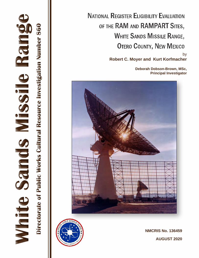
Cover photograph: Project radars at RAM Site, WSMR, NM
RAM VHF/UHF signature radar in foreground with electromagnatic ground clutter shield interposed with the RAMPART “S” band tracking radar in the
background (looking toward west with Organ Mountains in background).
Photographer; Robert G. Tucker (CIV) U.S. Army photograph, White Sands Missile Range
REPORT DOCUMENTATION PAGE
Form Approved
OMB No. 0704-0188
Public Reporting burden for this collection of information is estimated to average 1 hour per response, including the time for reviewing instructions, searching existing data sources, gathering and maintaining the data needed, and completing and reviewing the collection of information. Send comments regarding this burden estimate or any other aspect of this collection of information, including suggestions for reducing this burden, Washington Headquarters Services, Directorate for Information Operations and Reports, 1215 Jefferson Davis Highway, suite 1204, Arlington, VA 22202-4302, and to the Office of Management and Budget, Paperwork Reduction Project (0704-0188), Washington, D.C. 20503 1. AGENCY USE ONLY (leave Blank) 2. REPORT DATE
August 2020 3. REPORT TYPE AND DATES COVERED
Final Report, September 2016 – August 2020
3. TITLE AND SUBTITLE
National Register Eligibility Evaluation of the RAM and RAMPART Sites, White Sands Missile Range, Otero County, New Mexico
5. FUNDING NUMBERS PR 10451734 WBS S.0005485.34.13.6
4. AUTHOR(S)
Robert Moyer, Kurt Korfmacher, and Deborah Dobson-Brown
7. PERFORMING ORGANIZATION NAME(S) AND ADDRESS(ES)
AmaTerra Environmental, Inc. 4009 Banister Lane, Suite 300 Austin, Texas 78704
8 PERFORMING ORGANIZATION REPORT NUMBER
Technical Report No. 173 Project 246-001-T6
9. SPONSRING/MONITORING AGENCY NAME(S) AND ADDRESS(ES)
Department of the Army White Sands Missile Range 100 Headquarters Avenue White Sands Missile Range, NM 88002
10. SPONSORING/MONITORING AGENCY REPORT NUMBER
WSMR Project No. 860
11. SUPPLEMENARY NOTES
12a. DISTRIBUTION AVAILABILITY STATEMENT
Available for public release
12b. DISTRIBUTION CODE
13. ABSTRACT (Maximum 200 words)
In 2016, cultural resource specialists contracted through the White Sands Missile Range (WSMR), Directorate of Public Works, Environmental Division performed a pedestrian survey of the RAM and RAMPART sites, located at WSMR, NM. The investigations were conducted as WSMR Project Number 860 and were registered with the New Mexico Cultural Resource Information System (NMCRIS) as Activity Number 136459. Field work identified 14 existing individual buildings and structures associated with RAM/RAMPART operations that could be matched with existing WSMR real property facility numbers. Several butane storage tanks were also identified. In addition, three other buildings that could not be matched to a WSMR building number or letter designation were assigned temporary field numbers and were recorded. RAM and RAMPART are recommended as eligible to the National Register of Historic Places as an historic district at national level under Criterion A in the areas of Communications and Military. In addition, three individual buildings – Facilities 25850A, 25875A, and 25880 – are recommended individually eligible under Criteria A and C (25880) and Criterion A (25850A and 25875A) in the areas of Communications and Military for their individual roles in the development of radar technology.
14. SUBJECT TERMS Architecture, History, White Sands Missile Range, National Historic Preservation Act
15. NUMBER OF PAGES: 72+app. 16. PRICE CODE
17. SECURITY CLASSIFICATION OF REPORT
Unclassified
18. SECURITY CLASSIFICATION OF THIS PAGE
Unclassified
19. SECURITY CLASSIFICATION OF THIS PAGE
Unclassified
20. LIMITATION OF ABSTRACT
Unclassified Standard Form 298 (rev. 2-89)(EG)
Prescribed by ANSI Std. 239.18

i
Abstract
AbstractIn 2016, cultural resource specialists contracted through the White Sands Missile Range (WSMR), Directorate of Public Works, Environmental Division performed a pedestrian survey of the RAM and RAMPART sites, located at WSMR, New Mexico (NM). The investigations were conducted as WSMR Project Number 860 and were registered with the New Mexico Cultural Resource Information System (NMCRIS) as Activity Number 136459.
Field work identified 14 existing individual buildings and structures associated with RAM and RAMPART operations that could be matched with existing WSMR real property facility numbers, including two butane storage tank facilities that were also identified. In addition, three other buildings that could not be matched to a WSMR building number or letter designation were assigned temporary field numbers and were recorded. Thus, the total number of buildings and structures identified during field work at the RAM and RAMPART sites was 17.
Set within the context of the Cold War, the RAM and RAMPART facilities were invaluable in the development of re-entry vehicle technology, a crucial component of the United States nuclear deterrent force. The development and use of these two facilities during the Cold War, a critical time in twentieth century American history, is a historically unique component of WSMR history.
The RAM and RAMPART sites are recommended as eligible to the National Register of Historic Places as an historic district. The RAM/RAMPART Historic District is historically significant at the national level of significance under Criterion A for its association with events that have contributed to the broad patterns of American history in the areas of Communications and Military. Additionally, the RAM and RAMPART radar units and the RAM clutter shield are recommended as individually eligible to the National Register of Historic Places at the national level of significance under Criterion A for their association with events that have contributed to the broad patterns of American history in the areas of Communications and Military. Since its scale is unique among existing examples of radar clutter shields, the RAM clutter shield is also recommended as individually eligible to the National Register of Historic Places under Criterion C for its embodiment of distinctive characteristics of a type of construction.

National Register Eligibility Evaluation of the RAM and RAMPART Sites White Sands Missile Range, Otero County, New Mexico
ii
iii
Acronyms
AcronymsABM Anti-Ballistic Missile
ABMDA Advanced Ballistic Missile Development Agency
ABMD Anti-Ballistic Missile Defense
ABRES Advanced Ballistic Re-Entry Systems
AFB Air Force Base
AFSC Air Force Systems Command
AMRAD ARPAT Measurements Radar
ARC Atlantic Research Corporation
ARDC Air Research and Development Command
ARGMA U.S. Army Rocket and Guided Missile Agency
ARL U.S. Army Research Laboratory
ARMS State of New Mexico Archaeological Records Management System
ARPA Advanced Research Projects Agency
ARPAT Advanced Research Projects Agency Terminal
BMD Ballistic Missile Defense
BRL Aberdeen Proving Ground’s Ballistic Research Laboratory
CD Compact Disc
CIA Central Intelligence Agency
CMU Concrete Masonry Unit
D/BMRS Deputy for Ballistic Missile Re-entry Systems
DOD Department of Defense
DPW Directorate of Public Works
National Register Eligibility Evaluation of the RAM and RAMPART Sites White Sands Missile Range, Otero County, New Mexico
iv
DR Discrimination Radar
EOVAF Electro-Optical Vulnerability Assessment Facility
GIS Geospatial Information System
GRTS Green River Test Site
HCPI State of New Mexico Historic Cultural Property Inventory Form
HELSTF High Energy Laser Systems Test Facility
HSR Human Systems Research
HUMINT Human Intelligence
ICBM Intercontinental Ballistic Missile
ICT International Christian Television
IRBM Intermediate Range Ballistic Missile
JPL California Institute of Technology’s Jet Propulsion Lab
KM Kilometer
KVA Kilovolt Amp
LA State of New Mexico Laboratory of Anthropology
LC Launch Complex
LORV Low Observable Re-Entry Vehicle
MAD Mutually Assured Destruction
MAR Multifunction Array Radar
MIRVs Multiple Independently-Targeted Re-entry Vehicles
MIT Massachusetts Institute of Technology
NATO North Atlantic Treaty Organization
NMCRIS New Mexico Cultural Resources Information System
v
Acronyms
NHPA National Historic Preservation Act
NM New Mexico
NMSHPO New Mexico State Historic Preservation Officer
NPS National Park Service
NRHP National Register of Historic Places
NRO National Range Operations
ORDCIT Ordnance Department/California Institute of Technology
PLRS Position Location Reporting System
PRESS Pacific Range Electromagnetic Signature Study
PRF Pulse Repetition Frequency
PSL Physical Science Lab
RAMPART Radar Advanced Measurements Program for Analysis of Re-entry Techniques
RAM Radar Acquisition Measurements
REBA Relativistic Electron Beam Accelerator
SALT I and II Strategic Arms Limitations Talks
SAMSO Space and Missile Systems Organization
SLAD Survivability/Lethality Analysis Directorate
SRAM AGM-69 Short Range Attack Missile
TCEE Temperature Controlled Environmental Enclosure
TE Testing and Evaluation
TTR Target Tracking Radar
UHF Ultra High Frequency
ULC Utah Launch Complex
National Register Eligibility Evaluation of the RAM and RAMPART Sites White Sands Missile Range, Otero County, New Mexico
vi
U.S. United States
U.S.S.R. Union of Soviet Socialist Republics
USAF United States Air Force
VA Virginia
VHF Very High Frequency
WAC Without Attitude Control
WDD Western Development Division
WES Waterways Experiment Station
WSMR White Sands Missile Range
WSPG White Sands Proving Ground
WWII World War II
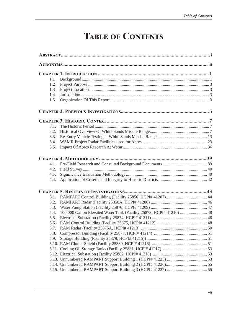
Table of Contents
vii
Table of Contents
Abstract ..................................................................................................................... i
Acronyms ................................................................................................................. iii
Chapter 1. Introduction ....................................................................................... 11.1 Background ...................................................................................................................... 11.2 Project Purpose ................................................................................................................ 31.3 Project Location ............................................................................................................... 31.4 Jurisdiction ....................................................................................................................... 31.5 Organization Of This Report ............................................................................................ 3
Chapter 2. Previous Investigations.....................................................................5
Chapter 3. Historic Context ................................................................................73.1. The Historic Period .......................................................................................................... 73.2. Historical Overview Of White Sands Missile Range ....................................................... 73.3. Re-Entry Vehicle Testing at White Sands Missile Range .............................................. 133.4. WSMR Project Radar Facilities used for Abres ............................................................ 233.5. Impact Of Abres Research At Wsmr .............................................................................. 36
Chapter 4. Methodology .................................................................................... 394.1. Pre-Field Research and Consulted Background Documents ......................................... 394.2. Field Survey ................................................................................................................... 404.3. Significance Evaluation Methodology ........................................................................... 404.4. Application of Criteria and Integrity to Historic Districts ............................................. 42
Chapter 5. Results of Investigations ................................................................ 435.1. RAMPART Control Building (Facility 25850, HCPI# 41207) ...................................... 445.2. RAMPART Radar (Facility 25850A, HCPI# 41208) .................................................... 465.3. Water Pump Station (Facility 25870, HCPI# 41209) .................................................... 475.4. 100,000 Gallon Elevated Water Tank (Facility 25873, HCPI# 41210) ......................... 485.5. Electrical Substation (Facility 25874, HCPI# 41211) ................................................... 485.6. RAM Control Building (Facility 25875, HCPI# 41212) .............................................. 485.7. RAM Radar (Facility 25875A, HCPI# 41213) ............................................................. 505.8. Compressor Building (Facility 25877, HCPI# 41214) ................................................. 515.9. Storage Building (Facility 25879, HCPI# 41215)) ....................................................... 515.10. RAM Clutter Shield (Facility 25880, HCPI# 41216) ................................................... 515.11. Cooling Oil Storage Tanks (Facility 25881, HCPI# 41217) ......................................... 535.12. Electrical Substation (Facility 25882, HCPI# 41218) .................................................. 535.13. Unnumbered RAMPART Support Building 1 (HCPI# 41225) ..................................... 535.14. Unnumbered RAMPART Support Building 2 (HCPI# 41226) ...................................... 555.15. Unnumbered RAMPART Support Building 3 (HCPI# 41227) ..................................... 55

National Register Eligibility Evaluation of the RAM and RAMPART Sites White Sands Missile Range, Otero County, New Mexico
viii
Chapter 6. Eligibility Assessments and Management Recommendations ..576.1. Previous Eligibility Recommendations .......................................................................... 576.2. National Register Eligibility Recommendations............................................................ 57
References .............................................................................................................. 67
Appendix. Historic Cultural Property Inventory Forms (Files on attached CD)
List of Figures and Tables
ix
List of Figures
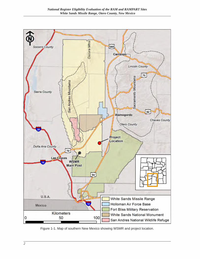
Figure 1-1. Map of southern New Mexico showing WSMR and project location. ................... 2
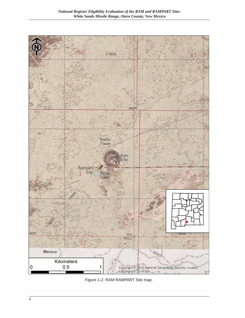
Figure 1-2. RAM RAMPART Site map. ................................................................................... 4
Figure 3-1. Aerial View of White Sands Proving Ground, 1946 (Photo: WSMR DPW Archives). ..................................................................................................... 12
Figure 3-2. Four-stage Athena launch from Area J at Green River, UT on July 14, 1966 (Photo: Feit et al.: 28. Original Photo Credit: Moore Collection, John Wesley Powell River Museum). .................................................................... 17
Figure 3-3. Diagram of four-stage Athena test vehicle (Photo: Marsh: 2-2). ......................... 17
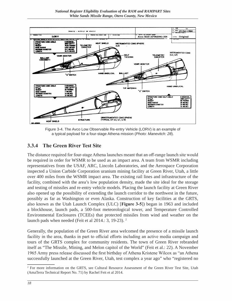
Figure 3-4. The Avco Low Observable Re-entry Vehicle (LORV) is an example of a typical payload for a four-stage Athena mission (Photo: Manevitch: 28). ........ 18
Figure 3-5. GRTS Missile Assembly Area, ca. 1973 (Photo: Feit et al 2014.: 21. Original Photo Credit: Larry O. Phabris, U.S. Army). ........................................ 19
Figure 3-6. Typical flight profile for a four-stage Athena launch (Photo: Marsh: 2-12). ..... 20
Figure 3-7. WSMR instrumentation used during the ABRES program (Photo: Atlantic Research Corporation 1969). .................................................................. 22
Figure 3-8. Rondo Site “A”, January 25, 1966 (Photo: WSMR Museum). ............................. 23
Figure 3-9. VHF project radar at Stallion Site (Photo: Aerospace Corporation: 5-2). ........... 24
Figure 3-10. RAM antenna and control building inside “clutter fence”, with RAMPART antenna and control building nearby at lower right (Photo: Feit et al.: 30. Original Photo Credit: White Sands Missile Range Museum). .... 27
Figure 3-11. Radar Acquisition Measurements (RAM) Facility. (Photo: WSMR Museum). .... 28
Figure 3-12. Col. Leonard R. Sugerman (second from left), chief of the Air Force’s Inland Range Field Office at WSMR, prepares to place the final bolt in the RAM clutter fence, December 1969. (Photo: WSMR Museum). .................... 28
Figure 3-13. Diagram of REBA electromagnetic research apparatus (Photo: United States Energy Research & Development Administration n.d.: 15). ...................... 30
Figure 3-14. Current condition of REBA (Photo courtesy of William Godby). ........................ 30
Figure 3-15. Installation of the AMRAD antenna atop the radar pedestal, November 14, 1962 (Photo: White Sands Missile Range Museum). ...................................... 33
Figure 3-16. An AMRAD technician consults a Type 547 Oscilloscope (Photo: WSMR Museum). .................................................................................................. 33
National Register Eligibility Evaluation of the RAM and RAMPART Sites White Sands Missile Range, Otero County, New Mexico
x
Figure 3-17. An AMRAD technician examines a display (Photo: WSMR Museum). ............... 34
Figure 3-18. A technician adjusts a circuit board at an AMRAD electronic equipment rack (Photo: WSMR Museum). ........................................................... 34
Figure 3-19. This 1967 photo shows the unique shape of the AMRAD clutter fence (Photo: WSMR Museum). ..................................................................................... 35
Figure 5-1. Resource location map. ......................................................................................... 45
Figure 5-2. Facility 25850, facing northwest. ......................................................................... 46
Figure 5-3. Facility 25850a. .................................................................................................... 46
Figure 5-4. Facility 25870. ...................................................................................................... 47
Figure 5-5. Facility 25873. ...................................................................................................... 48
Figure 5-6. Facility 25874. ...................................................................................................... 49
Figure 5-7. Facility 25875. ...................................................................................................... 49
Figure 5-8. Facility 25875a. .................................................................................................... 50
Figure 5-9. Facility 25877. ...................................................................................................... 51
Figure 5-10. Facility 25879. ...................................................................................................... 52
Figure 5-11. Facility 25880. ...................................................................................................... 52
Figure 5-12. Facility 25881. ...................................................................................................... 53
Figure 5-13. Facility 25882. ...................................................................................................... 54
Figure 5-14. Unnumbered Support Building 1. ......................................................................... 54
Figure 5-15. Unnumbered Support Building 2. ......................................................................... 55
Figure 5-16. Unnumbered Support Building 3. ......................................................................... 56
Figure 6-1. Contributing Resources and Proposed NRHP Boundary for the recommended RAM/RAMPART Historic District. ............................................. 66
List of Figures and Tables
xi
List of Tables
Table 3-1. ABRES Radar Comparison (Sources: White Sands Missile Range n.d.b: 24, 32, 34; Aerospace Corporation 1963: 5-1–5-10). ................................. 24
Table 5-1. RAM and RAMPART Facilities ........................................................................... 43
Table 6-1. Contributing Status of Historic Resources. .......................................................... 64
Table 6-2. NRHP Boundary UTM. ........................................................................................ 65

National Register Eligibility Evaluation of the RAM and RAMPART Sites White Sands Missile Range, Otero County, New Mexico
xii
Chapter 1—Introduction
1
Chapter 1
IntroductionIn July of 2016, AmaTerra conducted a cultural resource survey of the Radar Acquisition Measurements (RAM) and Radar Advanced Measurements Program for Analysis of Reentry Techniques (RAMPART) sites at White Sands Missile Range (WSMR) in Otero County, New Mexico. The investigation was designed to inventory any historic properties situated at the two sites and to assess their eligibility for inclusion in the National Register of Historic Places (NRHP) outlined under Sections 106 and 110 of the National Historic Preservation Act (NHPA) of 1966, as amended (16 ASC 470). The NHPA requires that federal agencies and departments identify, evaluate, and nominate to the NRHP historic properties within their jurisdiction. At WSMR, this responsibility is managed by the Directorate of Public Works (DPW), Environmental Division. The investigations reported herein were conducted as WSMR Project Number 860 and were registered with the New Mexico Cultural Resource Information System (NMCRIS) as Activity Number 136459.
1.1 BackgroundThe United States Army established the Alamogordo Bombing Range in 1942, followed by establishment of the White Sands Proving Ground (WSPG) in 1945. In 1958, the consolidated ranges were renamed as White Sands Missile Range. Today, WSMR is the largest military installation in the United States of America (U.S.). Located in the Tularosa Basin of south-central New Mexico, the range encompasses almost 3,200 square miles, or more than two million acres.
The main cantonment is located 20 miles (32 kilometers [km]) east of Las Cruces, New Mexico, along the eastern foothills of the Organ Mountains. WSMR surrounds the 143,733-acre White Sands National Monument, which is managed by the National Park Service (NPS), and the 57,215- acre San Andres National Wildlife Refuge, which is managed by the U.S. Fish and Wildlife Service. Adjacent to WSMR on the east, is the 59,639-acre Holloman Air Force Base, and to the south lies the 1.1 million acre Fort Bliss and McGregor Range (Figure 1-1).
WSMR is part of the U.S. Army Installation Management Command and is home to a broad array of military testing programs, ranging from the largest land missile range in the western hemisphere to environmental testing chambers and computer modeling laboratories. In recent years, military training has been added to the activities conducted within WSMR’s extensive landholdings.
National Register Eligibility Evaluation of the RAM and RAMPART Sites White Sands Missile Range, Otero County, New Mexico
2
Figure 1-1. Map of southern New Mexico showing WSMR and project location.
Chapter 1—Introduction
3
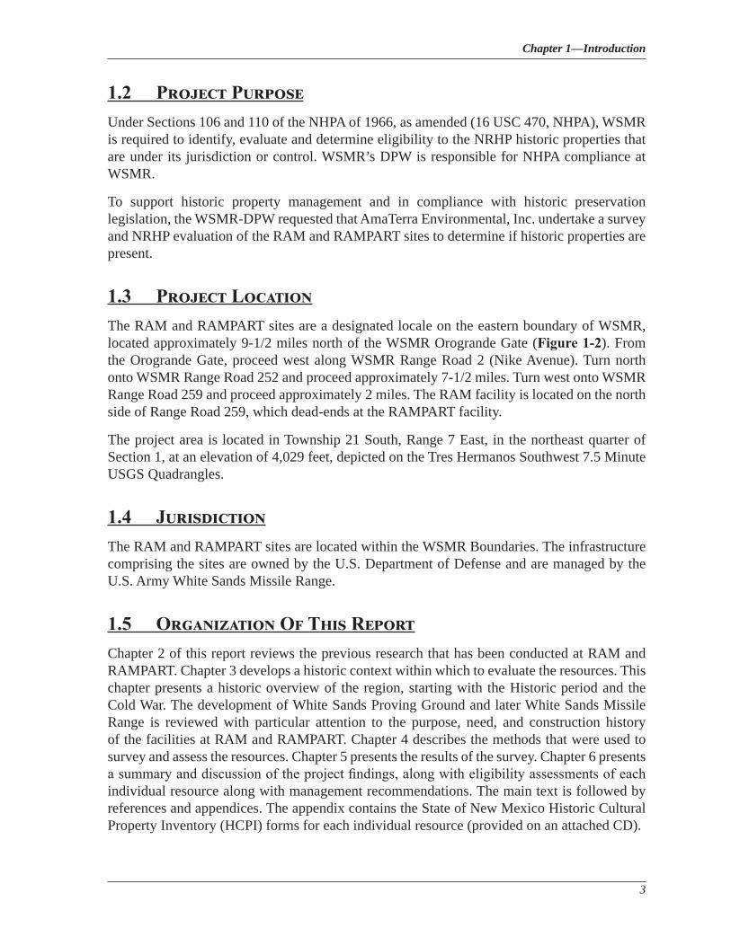
1.2 Project PurposeUnder Sections 106 and 110 of the NHPA of 1966, as amended (16 USC 470, NHPA), WSMR is required to identify, evaluate and determine eligibility to the NRHP historic properties that are under its jurisdiction or control. WSMR’s DPW is responsible for NHPA compliance at WSMR.
To support historic property management and in compliance with historic preservation legislation, the WSMR-DPW requested that AmaTerra Environmental, Inc. undertake a survey and NRHP evaluation of the RAM and RAMPART sites to determine if historic properties are present.
1.3 Project LocationThe RAM and RAMPART sites are a designated locale on the eastern boundary of WSMR, located approximately 9-1/2 miles north of the WSMR Orogrande Gate (Figure 1-2). From the Orogrande Gate, proceed west along WSMR Range Road 2 (Nike Avenue). Turn north onto WSMR Range Road 252 and proceed approximately 7-1/2 miles. Turn west onto WSMR Range Road 259 and proceed approximately 2 miles. The RAM facility is located on the north side of Range Road 259, which dead-ends at the RAMPART facility.
The project area is located in Township 21 South, Range 7 East, in the northeast quarter of Section 1, at an elevation of 4,029 feet, depicted on the Tres Hermanos Southwest 7.5 Minute USGS Quadrangles.
1.4 JurisdictionThe RAM and RAMPART sites are located within the WSMR Boundaries. The infrastructure comprising the sites are owned by the U.S. Department of Defense and are managed by the U.S. Army White Sands Missile Range.
1.5 Organization Of This ReportChapter 2 of this report reviews the previous research that has been conducted at RAM and RAMPART. Chapter 3 develops a historic context within which to evaluate the resources. This chapter presents a historic overview of the region, starting with the Historic period and the Cold War. The development of White Sands Proving Ground and later White Sands Missile Range is reviewed with particular attention to the purpose, need, and construction history of the facilities at RAM and RAMPART. Chapter 4 describes the methods that were used to survey and assess the resources. Chapter 5 presents the results of the survey. Chapter 6 presents a summary and discussion of the project findings, along with eligibility assessments of each individual resource along with management recommendations. The main text is followed by references and appendices. The appendix contains the State of New Mexico Historic Cultural Property Inventory (HCPI) forms for each individual resource (provided on an attached CD).
National Register Eligibility Evaluation of the RAM and RAMPART Sites White Sands Missile Range, Otero County, New Mexico
4
Figure 1-2. RAM RAMPART Site map.
Chapter 2—Previous Investigations
5
Chapter 2
Previous InvestigationsPrior to the 2016 field work, an electronic search of the State of New Mexico’s Archaeological Records Management System (ARMS) was conducted to identify any previously recorded cultural resources within the project area. WSMR archaeological maps and Geospatial Information Systems (GIS) data sets were also consulted.
According to ARMS, RAMPART contains one previously recorded site, LA112446. The site was recorded by Human Systems Research (HSR) in 1996 and consisted of an adobe wall five meters long and 10 centimeters wide that was exposed in a road cut with a depth of 10 centimeters. No other artifacts were noted, and no NRHP eligibility recommendations or determinations were listed.
WSMR GIS shapefiles indicate that ARMS Resource Number LA116566 was assigned to RAM and Resource Number LA116567 was assigned to RAMPART by HSR in 1996. HSR assigned these resource numbers in connection with field research for the writing of HSR Report No. 9422, Star Throwers of the Tularosa: The Early Cold War Legacy of White Sands Missile Range. ARMS confirmed the LA numbers and also associated NMCRIS Activity Number 56033 with LA116566, and NMCRIS Activity Numbers 56033 and 80389 with LA116567.
Research by HSR for Project No. 9422 included recordation of RAM and RAMPART historic resources in May of 1996. The 1996 survey included a selection of buildings and structures at RAM and RAMPART. These included Facilities 25850, 25870 (listed under the original USAF designation of 6002), 25875, 25879 (listed as 25875C), 25877, and 25880, as well as the RAMPART radar tower (identified by HSR as Facility 25859), the RAM radar tower (identified by HSR as Facility 25878), an associated antennae mast, a wood trailer building (apparently the same building identified in this report as RAMPART Building 2), liquid propane gas storage tanks, and water storage tanks. The survey briefly mentioned the historic context of RAM and RAMPART facilities, but the NRHP eligibility of the facilities are “potentially eligible.” A June 9, 2004 letter from WSMR Environment and Safety Directorate Director Thomas Ladd to the New Mexico State Historic Preservation Officer (NMSHPO) noted a re-evaluation of 41 buildings (including some, if not all of the buildings at RAM and RAMPART) under Criteria Consideration G for properties attaining significance within the past 50 years determined the 41 buildings not eligible for NRHP listing.
No HCPI numbers were assigned for any of the LA numbers listed above.

National Register Eligibility Evaluation of the RAM and RAMPART Sites White Sands Missile Range, Otero County, New Mexico
6
Chapter 3—Historic Context
7
Chapter 3
Historic ContextThe following sections, 3.1 and 3.2, as well as Figure 3.1, are taken verbatim from the report National Register Eligibility Recommendations of the Mule Peak Site, Lincoln National Forest in Otero County, New Mexico (AmaTerra Technical Report No. 104), written in March 2015 by Jim Jenks et al.:
3.1. The Historic PeriodBeginning with the colonization of the region by the Spanish in the late 16th century, the Historic period underwent three major changes in political organization. Strong colonial ties with Spain for the first 300 years prompted the establishment of missions and the allocation of lands for non-indigenous use throughout what is now New Mexico. The only interruption in this three-century reign was the Pueblo Revolt of 1680, during which Spanish settlers and indigenous sympathizers were ousted from New Mexico and forced to flee to El Paso. This hiatus lasted until the re-conquest of 1692, when Spanish control was reasserted in northern New Mexico.
By 1821, descendants of the original Spanish colonizers gained independence from Spain under the political entity of Mexico, which included modern-day New Mexico. New Mexico remained part of Mexico until 1846, when American troops invaded and subsequently took control of the region. The Gadsden Purchase of 1853 delineated the U.S.-Mexico boundary, which remains intact today (U.S. Army 2001). The Homestead Act of 1862, which under its provisions allowed for private ownership of land, acted as a catalyst for further settlement of the Tularosa Basin. These new settlers grazed cattle on the vast, open rangeland of the basin for over six decades (Bureau of Land Management 2013).
World War II (WWII) brought on an increased need for weapons testing and development for the purpose of national defense. The sparsely populated desert of the Tularosa Basin was chosen by the U.S. military for the establishment of the Alamogordo Bombing Range in 1942, and the White Sands Proving Ground (WSPG) in 1945 (Eckles 2013).
3.2. Historical Overview Of White Sands Missile Range
3.2.1 The Cold War
The rivalry between the U.S. and the Union of Soviet Socialist Republics (U.S.S.R.) for influence over the post-WWII world emerged before the war ended. Significant ideological differences separated the two countries and became more pronounced once the shared threat of Nazi Germany was defeated. WSPG was established in the immediate wake of WWII,
National Register Eligibility Evaluation of the RAM and RAMPART Sites White Sands Missile Range, Otero County, New Mexico
8
and as the Cold War intensified, White Sands became a primary test site for the weapons and technology of the Cold War (Salmon 2011).
In 1947, President Harry S. Truman’s secretary of state, George C. Marshall, proposed U.S. aid to rebuild Europe and a devastated Japan. Known as the Marshall Plan, the U.S. pledged billions in economic assistance and prevented the complete economic collapse of much of Western Europe. The plan also promoted the idea of shared national interests, which continued with the establishment of the North Atlantic Treaty Organization (NATO). NATO, designed to rebuff U.S.S.R. military intensions and influence into Western Europe, became the first peacetime military alliance entered into by the United States (Salmon 2011).
While the U.S. financed reconstruction in Western Europe, U.S.S.R. Premier Josef Stalin dictated policy in Soviet-occupied Eastern Europe. Determined to build a defensive buffer between East and West, the U.S.S.R. established Communist governments in eastern European countries. In 1949, the U.S. adopted the strategy of “Containment,” whereby the United States would check U.S.S.R. global advances using a variety of political and military methods. Truman embraced Containment and merged it with his own Truman Doctrine, announcing that the U.S. would support foreign governments resisting “armed minorities” or “outside pressures”—that is, Communist revolutionaries or the U.S.S.R. Truman’s adoption of the containment doctrine and his characterization of the Communist threat shaped American foreign policy for the subsequent four decades (United States Department of Defense 1975).
In 1950, American foreign policy got their first real test when the Korean Peninsula became the setting for the first “hot” confrontation between the U.S. and the U.S.S.R. China had fallen to Communist forces, and both China and the U.S.S.R. supported a North Korean invasion of South Korea. The United Nations, led by the U.S., voted to intervene in the war to defend the south. The invasion made containment all the more pertinent; foreign policy makers in the U.S. viewed the North Korean invasion as evidence that the U.S.S.R. did in fact hope to spread Communism, and as a threat to American efforts to rebuild and democratize Japan (Salmon 2011).
To support increased resistance to U.S.S.R. expansion, Truman’s new National Security Council submitted a classified document known as National Security Council Memorandum 68 (NSC-68), which suggested that Truman quadruple military spending for purposes of containment. The president readily consented and within a few years, the U.S. armed forces boasted more than 3 million men and the U.S. was spending roughly 15 percent of its gross national product on the military. WSPG was a beneficiary of this largesse, and the early 1950s ushered in a massive expansion of Proving Ground facilities, programs, and personnel during that pivotal Cold War decade (United States Department of Defense 1975; United States Department of Defense 1960).
By the time President Dwight D. Eisenhower took the oath of office in 1953, American soldiers had been entrenched in Korea for nearly three years. Eisenhower signed an armistice with North Korea, in part by making it known that he, unlike Truman, would consider the use of nuclear weapons in Korea. Eisenhower’s “New Look” foreign policy proposed the use of nuclear
Chapter 3—Historic Context
9
weapons and new technology rather than high numbers of ground troops and conventional bombs, all in an effort to threaten “massive retaliation” against Communist advances abroad. In addition, this emphasis on new technologically advanced weapons, instead of a large standing army, drastically reduced military spending, which had escalated rapidly during the Truman years. But while Eisenhower managed to stabilize defense spending, the doctrine of massive retaliation proved to be flawed because it effectively left the United States with few options to combat Soviet aggression (Salmon 2011).
In October 1957, U.S.S.R. scientists shocked the world when they announced they had successfully launched the first man-made satellite, Sputnik I, into orbit. Although the satellite posed no danger to the U.S., Americans feared that the U.S.S.R. now had the capability to attack the U.S. with intercontinental ballistic missiles (ICBMs) from anywhere on the planet. In reality, the U.S.S.R. ICBM development lagged far behind its American counterpart but the perception influenced new American defense spending to support anti-ballistic missile (ABM) programs. Many of these programs, such as the NIKE program, were tested at White Sands. The Advanced Ballistic Re-entry System program (ABRES) was tested at Green River, Utah. (United States Department of Defense 1975).
After entering office in 1961, President John F. Kennedy devised a new strategy of “flexible response” to deal with the U.S.S.R. The flexible response doctrine was meant to allow the president to combat Soviet advances around the world through a variety of means, including troop deployment, covert actions by the Central Intelligence Agency (CIA), or, as a last resort, use nuclear weapons (Salmon 2011).
But despite this flexibility, Kennedy was unable to avoid conflict with the U.S.S.R. when they attempted to place nuclear missiles in Cuba. The tension-filled confrontation, known as the Cuban Missile Crisis, was the closest the U.S. and the U.S.S.R. came to a nuclear exchange during the Cold War. Though U.S.S.R. missiles were removed from Cuba, the conflict foreshadowed direct American involvement in another land-war in Asia (Salmon 2011; United States Department of Defense 1975).
Kennedy first applied his new doctrine to the perceived problem in Vietnam. He drastically increased U.S. involvement in the Vietnamese civil war, which had been raging since the mid-1950s. The arrival of the first group of soldiers, as military advisors to the South Vietnamese government, established the pattern and by 1968, there were over 500,000 American combat personnel in Vietnam. Eventually, Kennedy and his successor Lyndon B. Johnson would find it politically impossible to recall U.S. forces without having first defeated the pro-Communist North Vietnamese. (United States Department of Defense 1975).
But by the early 1970s, the massive U.S. presence in Vietnam became untenable, and American troops were withdrawn, leading to the collapse of the South Vietnamese government and communist victory. More broadly, the U.S. and U.S.S.R. struggled to adjust to a new, more complicated pattern of international relations in which the world was no longer divided into two clearly opposed blocs. Further, the world economy declined dramatically, leading both super powers to re-asses their military commitments and defense spending (Salmon 2011).
National Register Eligibility Evaluation of the RAM and RAMPART Sites White Sands Missile Range, Otero County, New Mexico
10
The new climate of Détente, a general easing of superpower tensions, had both strategic and economic benefits for both sides of the Cold War, buoyed by their common interest in trying to check the further proliferation of nuclear weapons. A series of arms control agreements such as Strategic Arms Limitations Talks (SALT I and SALT II) were designed to limit the development of strategic weapons, slow the arms race and lessen large defense budgets. The U.S. also experienced a series of international frustrations, especially the fall of South Vietnam, which raised fears over the efficacy of American foreign policy. As a result, U.S. policy makers were more hesitant to commit American soldiers to overseas conflicts. (United States Department of Defense 1975; Salmon 2011).
However, in the 1980s, the Cold War re-intensified with the election of President Ronald Reagan and the U.S.S.R. invasion of Afghanistan. In the face of perceived U.S.S.R. aggression and eager to engage with the U.S.S.R. from a place of strength following Détente, Reagan adopted a more confrontational approach to U.S.S.R. communism by large increases in defense spending. Along with the complex war in Afghanistan, the U.S.S.R.’s attempt to keep pace with America’s military and technological advances was a significant factor in the decline of its state-run economy, despite political reforms ushered in by the progressive U.S.S.R. leader Mikhail Gorbachev (Salmon 2011).
In 1988, the U.S.S.R. withdrew from Afghanistan and one year later the Berlin Wall was torn down by German citizens, bringing a symbolic end to the Cold War. In December 1991, two years after President Reagan left office, the Cold War ended when Gorbachev dissolved the U.S.S.R. by decree (Salmon 2011).
3.2.2 Establishment of White Sands Proving Ground
The American need for an extended rocket test range dates to the modest beginning of the U.S. Army’s missile testing program and to the deadly experience with German rockets in the last year of WWII. In June 1944, the U.S. Army’s Ordnance Department (ORD) awarded a contract to the California Institute of Technology’s Jet Propulsion Lab (JPL) for the research and development of long-range, surface to surface rockets. The program, known as Ordnance Department/California Institute of Technology (ORDCIT), developed three early rocket types, the Private A, Private F, and Without Attitude Control (WAC) Corporal (United States Department of Defense 1960).
At the same time, the United States and its allies experienced firsthand the power of this new weapon. Germany’s V-2 rocket was the world’s first long-range ballistic missile, and allied targets absorbed thousands of V-2 attacks from 1944 to 1945. In the closing days of the war, the U.S. Army captured V-2 launch sites, rocket components and related instrumentation, and, most importantly, German scientists. By war’s end, the U.S. Army had successfully appropriated the German rocket program, sending captured personnel and equipment to the United States for use in an emerging American program (Eckles 2013).
In 1945, the U.S. Army initiated a search for a rocket testing ground location. Proposed test areas required flat and open ground over a contiguously large land base, a sparse population,
Chapter 3—Historic Context
11
and predominantly clear weather. The Army also sought a location which offered access to transportation infrastructure and utilities, and proximity to an existing military post for support. Preferred characteristics included surrounding hills or mountains which formed natural barriers to nearby population centers, but which enabled observation sites. Southeast New Mexico’s Tularosa Basin, near Fort Bliss, was identified as the best choice, possessing nearly all of the desired characteristics. The site recommendation from the Army’s Chief of Ordnance was approved by the Secretary of War on February 20, 1945. Armed Forces Circular #268 announced that WSPG was officially activated on July 9, 1945 (Eckles 2013).
Just seven days after the activation of WSPG, the world’s first atomic bomb was exploded on what was then the Alamogordo Bombing Range. Developed in secret and unknown to commanders at the new proving ground, wartime use of atomic weapons quickly ended WWII and began the nuclear age. Known as the Trinity Site, the atomic test area was incorporated into the boundaries of the massive new proving ground (Eckles 2013).
Early Development of White Sands Proving GroundInitially anticipated as a temporary facility, the Army planned to use the range for no more than six weeks, launching just 10 to 15 missiles. Accordingly, the Army erected temporary wood-frame buildings and metal hangars at the new cantonment, and began the construction of necessary launch facilities. The Army’s first blockhouse and V-2 launch area, now known as Launch Complex 33 (LC-33), was constructed approximately six and a half miles east of the main post, and on September 26, 1945, a Tiny Tim booster became the first vehicle launched at WSPG. In October, a full WAC Corporal with the Tiny Tim booster was launched, reaching an altitude of 43.5 miles (United States Department of Defense 1960; Building Technology Inc. 1984).
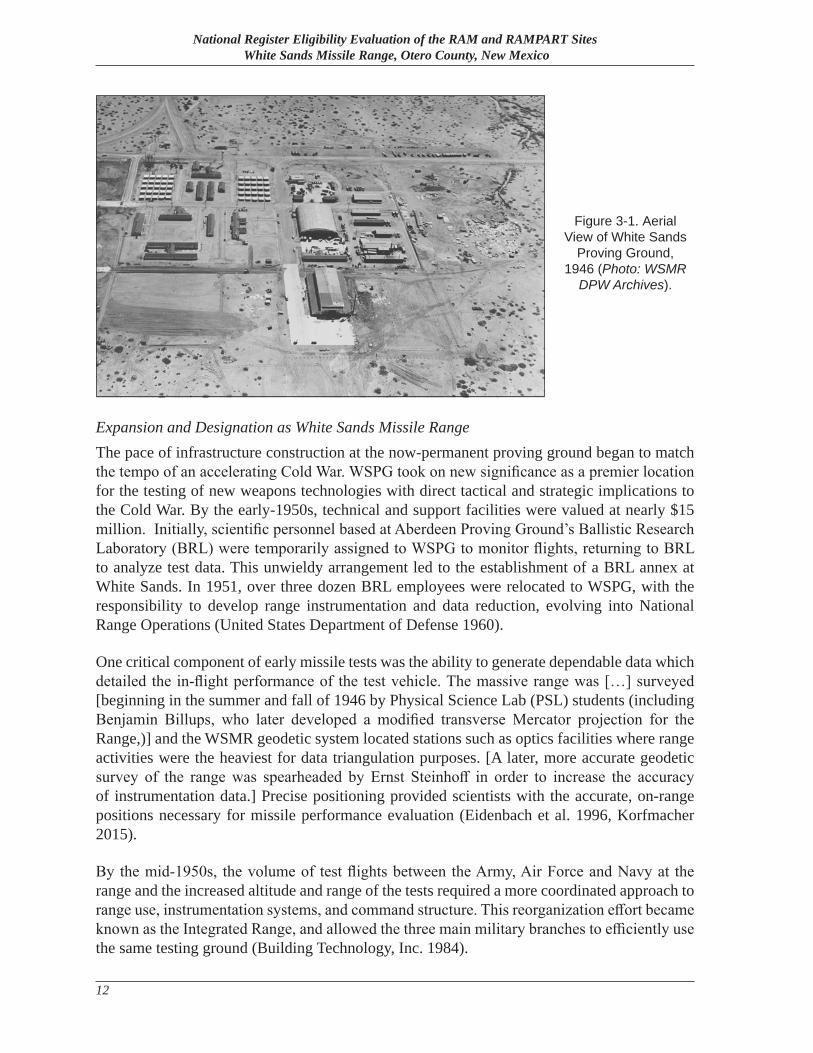
Meanwhile, over 300 boxcars of captured V-2 components arrived at WSPG. German rocket scientists were assigned to the proving ground to aid in the development of an American program based on the V-2. By April 1946, the first tests of the re-assembled V-2 rockets were underway and a second missile assembly building had been constructed at the main post (Figure 3-1).
That same year, the first instrumentation site, designated “A” Station, was completed one mile south of the V-2 launch site. A-station proved too close to the launch point, so its equipment was moved to a new site, C-Station, which was located approximately three miles south of LC-33. Many smaller instrumentation and tracking stations followed, but C-Station became WSPG’s first range control center, combining missile control, instrumentation, and tracking facilities in one facility (Building Technology, Inc. 1984).
Between 1946 and 1952, a total of sixty-seven V-2’s were fired from WSPG. American scientists and their German counterparts used the V-2s to conduct upper atmospheric tests critical to rocket performance and evaluation and gained valuable experience in all aspects of rocketry. The V-2 served as a prototype to a number of new missiles developed by the U.S. military and as the 1950s unfolded, WSPG took its place at the forefront of American missile development and testing (United States Department of Defense 1960; Eckles 2013).
National Register Eligibility Evaluation of the RAM and RAMPART Sites White Sands Missile Range, Otero County, New Mexico
12
Expansion and Designation as White Sands Missile RangeThe pace of infrastructure construction at the now-permanent proving ground began to match the tempo of an accelerating Cold War. WSPG took on new significance as a premier location for the testing of new weapons technologies with direct tactical and strategic implications to the Cold War. By the early-1950s, technical and support facilities were valued at nearly $15 million. Initially, scientific personnel based at Aberdeen Proving Ground’s Ballistic Research Laboratory (BRL) were temporarily assigned to WSPG to monitor flights, returning to BRL to analyze test data. This unwieldy arrangement led to the establishment of a BRL annex at White Sands. In 1951, over three dozen BRL employees were relocated to WSPG, with the responsibility to develop range instrumentation and data reduction, evolving into National Range Operations (United States Department of Defense 1960).
One critical component of early missile tests was the ability to generate dependable data which detailed the in-flight performance of the test vehicle. The massive range was […] surveyed [beginning in the summer and fall of 1946 by Physical Science Lab (PSL) students (including Benjamin Billups, who later developed a modified transverse Mercator projection for the Range,)] and the WSMR geodetic system located stations such as optics facilities where range activities were the heaviest for data triangulation purposes. [A later, more accurate geodetic survey of the range was spearheaded by Ernst Steinhoff in order to increase the accuracy of instrumentation data.] Precise positioning provided scientists with the accurate, on-range positions necessary for missile performance evaluation (Eidenbach et al. 1996, Korfmacher 2015).
By the mid-1950s, the volume of test flights between the Army, Air Force and Navy at the range and the increased altitude and range of the tests required a more coordinated approach to range use, instrumentation systems, and command structure. This reorganization effort became known as the Integrated Range, and allowed the three main military branches to efficiently use the same testing ground (Building Technology, Inc. 1984).
Figure 3-1. Aerial View of White Sands
Proving Ground, 1946 (Photo: WSMR
DPW Archives).
Chapter 3—Historic Context
13
WSPG was re-designated as White Sands Missile Range in 1958, a change that reflected the emphasis on the development of Intercontinental Ballistic Missile (ICBM) and Anti-Ballistic Missile Defense (ABMD) systems that were a major focus of the Cold War, particularly following the Soviet Union’s successful Sputnik 1. As the 1960s began, WSMR was classified as a National Missile Range (NMR), equally available to all government agencies (US DOD 1968:1). In 1962, activities related to the Advanced Ballistic Re-Entry Systems (ABRES) program, which studied the re-entry characteristics of ICBMs to improve both offensive and defensive systems were initiated at WSMR and at WSMR’s Utah Launch Complex in Green River, Utah (Eidenbach et al. 1996:63).
By the mid-1960s, over 1,000 precisely surveyed instrumentation sites complete with optical shelters and electronic instrument buildings stood throughout the range. Optical measuring devices, some recovered in Germany in the closing days of WWII, were a revolution in instrumentation technology. Tracking telescopes were adapted from astronomical use for high altitude missile tracking and high speed photo recordation. Cinetheodolites, meanwhile, were the workhorse of range instrumentation during the early decades, and produced filmed records of in-flight missile tests to provide data on location, acceleration, and flight characteristics (United States Department of Defense 1969).
The Modern Era at White Sands Missile RangeAs the 1970s unfolded, WSMR supported over 100 separate programs, including surface-to-surface and surface-to-air missiles and rockets, airborne weapons systems, space vehicle development, target missiles and rockets, re-entry physics research, bomb drop tests and upper atmospheric research. Various programs conducted concurrent tests across the range throughout the year, overseen during that time by nearly 10,000 civil service, military and contract personnel from each branch of the military. This era represents the zenith in overall base population and military, civil service and contract personnel. By 1995, the range had tested over 1,000 weapons and space systems.
Today, WSMR remains the largest all-over-land military reservation in the United States. WSMR retains its critical role leading missile development and test programs for the Army, Navy, Air Force, National Aeronautics and Space Administration (NASA), and other government agencies and private industry.
3.3. Re-Entry Vehicle Testing at White Sands Missile Range
3.3.1 Development of Nuclear Missiles
During the early years of the Atomic Age that began on July 16, 1945 with a nuclear detonation at Trinity Site, the size and weight of nuclear weapons meant that their delivery was limited to aircraft such as the B-29 Superfortress. This meant that the delivery of a nuclear weapon to its target included the speed and range restrictions of such an aircraft, as well as its vulnerability to interception by fighter aircraft. In March of 1954, however, the U.S. successfully detonated
National Register Eligibility Evaluation of the RAM and RAMPART Sites White Sands Missile Range, Otero County, New Mexico
14
two hydrogen bombs as part of Operation Castle in the Marshall Islands. The lighter weight and higher yield of these thermonuclear weapons prototypes demonstrated that it would be possible for ICBMs — which had none of a bomber aircraft’s speed, range, or vulnerability limitations — to serve as the delivery vehicles for nuclear warheads (Greenwood: 16-17).
After the success of the Operation Castle tests, the U.S. Air Force established the Western Development Division (WDD) in Inglewood, California as part of the Air Research and Development Command (ARDC) and gave the new division the responsibility of developing the Atlas, which would be the first U.S. ICBM. After successfully overseeing the development of the Atlas, the unit was renamed the Ballistic Missile Division (Feit et al 2014.: 20).1
Once the ballistic missile’s capability to carry nuclear payloads was established, engineers began to look for ways to increase the range and yield of ICBMs and the shorter range Intermediate Range Ballistic Missiles (IRBMs). The missiles faced an engineering challenge that was not an issue for bomber aircraft. Since ballistic missiles left the atmosphere during their flight, the missile warhead had to withstand the intense heat and pressure of atmospheric friction during re-entry. The earliest solution to this problem was a copper “heat sink” nosecone which could resist pressure and absorb heat while remaining intact, protecting a single warhead beneath it. However, the heat sink nosecone, which was employed on the United States Air Force (USAF) Thor IRBMs and early model Atlas ICBMs, was relatively heavy and therefore limited a missile’s maximum payload (Greenwood 1979: 55).
One rather effective way to increase the payload was to reduce the weight of the re-entry system, since each pound of weight saved in this area could then equate to a corresponding increase in the weight of the nuclear warhead. As a lighter alternative, researchers began to explore the effectiveness of ablative nosecones. Made of composites that were designed to divert re-entry heat away from a missile’s payload by ablating, or burning off, rather than absorbing heat and remaining intact, ablative nosecones became a “second generation” option that allowed missiles to increase nuclear yield by carrying heavier warheads (Greenwood 1979: 55).
3.3.2 Development of Re-entry Vehicles/Establishment of the ABRES Program
In addition to using the missile nosecone as a re-entry system, U.S. researchers also began to explore the concept of re-entry vehicles, which would surround ballistic missile warheads and provide re-entry protection independent of the missile body. As thermonuclear warheads became smaller and more efficient, limiting the re-entry system to protect only the warhead instead of the missile nosecone meant that less protective material could be used. This savings in payload weight, combined with the reduced weight of the warheads themselves and increases in the payload capability of ballistic missiles, also paved the way for a single ICBM to carry more than one warhead as well as radar countermeasures such as chaff.
1 On July 1, 1967, elements of the original Western Development Division were reorganized as the Air Force Systems Command’s Space and Missile Systems Organization (SAMSO) (O’Neill 1969: 1).
Chapter 3—Historic Context
15
The developing concepts of re-entry vehicles, and ballistic missile defense (BMD) systems to counter them, envisioned a new type of warfare that began to be conceptualized and examined by strategists. In 1961, the commander of Air Force Systems Command (AFSC) requested a “white paper” on the subject of ballistic missile re-entry systems. The white paper concluded that “the deployment of BMD systems creates an actual defensive combat zone,” and emphasized the importance of re-entry vehicles in such an environment by stating that each component of a ballistic missile except the re-entry vehicle should be considered “a logistic [element,] not a weapons element (Eidenbach et al 1996.: 61–63).”
As a result of the AFSC white paper, the ABRES Program (pronounced “a breeze” [Caldwell 1966: 20, 22]), also known as Program 627A, was established on May 14, 1963. ABRES was a joint service Department of Defense (DOD) program whose primary objective was “the evaluation of the offensive penetration capabilities of various U.S. ballistic re-entry systems” with the secondary benefit of “the application of [ABRES] data to the formulation of probable defensive techniques (Marsh 2-1).” Management of the program was assigned to the Deputy for Ballistic Missile Re-entry Systems (D/BMRS) office, which was located at Headquarters Ballistic Systems Division at Norton Air Force Base (AFB) in California. In the 1960s and early 1970s, the ABRES program was funded at $300 to $400 million per year, or approximately $2 billion per year by current standards (Feit et al 2014.: 20; Gansler 2010: 44).
The ABRES program was established with two separate components. For the first component, full-scale re-entry vehicle models would be launched from Vandenberg AFB in California over the Pacific Test Range toward Kwajalein Atoll. Radars in place at Kwajalein for testing and development of the Nike Zeus antiballistic missile system would be used to track and evaluate the full-scale re-entry vehicle models. The first such launch occurred on November 4, 1963, when an Atlas D carried the Chrysler Corporation’s REX-3 re-entry vehicle. In addition to the Pacific Test Range launches, five Atlas boosters was launched from Cape Canaveral, Florida as part of the ABRES program (O’Neil 1969l: 1-5; Ingwersen and Lemnios 2000: 252; Greenwood 1979: 130, 137–138).
As Philip A. Ingwersen and William Z. Lemnios noted in their 2000 article “Radars for Ballistic Missile Defense Research,” however, “as experiments…were planned it quickly became apparent that the Atlantic Ocean and Pacific Ocean ICBM tests would not begin to provide enough payload space for all the planned measurement programs, and that the cost of performing all the tests with ICBM vehicles would be prohibitive (255).” Recovery of flown re-entry vehicle models would also be more difficult when launching over water. Consequently, the Air Force decided that an additional component of the ABRES program would be the launch of scaled-down re-entry vehicle models using the facilities of an inland test range. After considering the instrumentation, security, and range-safety conditions at Eglin AFB, Florida; Point Mugu, California; Wallops Island, Virginia; and WSMR, the Air Force chose WSMR for overland ABRES launches. According to Ingwersen and Lemnios, “the security of the inland location and the prospect of using Nike Zeus test targets and obtaining data from the Zeus prototype radars at White Sands were major factors in the decision” (255).
National Register Eligibility Evaluation of the RAM and RAMPART Sites White Sands Missile Range, Otero County, New Mexico
16
3.3.3 The Athena Test Vehicle
In order to test scale models of re-entry vehicles, the Air Force needed a launch vehicle that was capable of boosting the models into flight paths and velocities that would mimic the flight of an inbound ICBM warhead, but could be produced and launched with less expense than an actual ICBM. The Air Force envisioned a vehicle similar to the Trailblazer series of missiles that NASA used to launch test targets from Wallops Island, Virginia for tracking by radars at nearby Arbuckle Neck, Virginia. The Trailblazer I missile consisted of six stages, three of which were used to boost a two-pound spherical re-entry body to an altitude of approximately 200 miles, after which the remaining three stages would drive the payload back toward launch site at a velocity of 20,000 feet per second (13,600 miles per hour, approximately Mach 18). The Trailblazer II operated in a similar manner, but consisted of four stages and could achieve the same velocity with a 35-pound payload (Ingwersen and Lemnios 2000: 247–248, 255; Salt Lake Tribune 1971).
As with the Trailblazer concept, the Athena booster that was developed for overland ABRES launches was a multi-stage missile. Initially the Athena, which was manufactured by Atlantic Research Corporation (ARC), utilized two basic configurations. A two-stage sounding rocket version of the Athena was created by combining Nike and Apache boosters. The two-stage Athena, which was launched and recovered within the range boundaries at WSMR, was not capable of boosting its payload to the terminal velocity of ICBM warheads, but could carry a 50- to 70-pound re-entry vehicle model above the atmosphere, then accelerate it to a re-entry speed of 4,000 feet per second (2,700 miles per hour, approximately Mach 3.5). The Athena sounding rocket was initially intended for use for 21 flights at WSMR. Although the two-stage configuration could not reach the altitudes and velocities required to simulate ICBM warheads, it was used in initial launches from the Green River Test Site (GRTS), apparently for systems validation (Marsh 1965: 2-1–2-3; Ingwersen and Lemnios 2000: 255; Atlantic Research Corporation 1971: 1).
The primary Athena test vehicle configuration consisted of four stages (Figures 3-2 and 3-3). The first stage consisted of a Castor booster with a Thiokol XM 13 engine and two Recruit auxiliary boosters with Thiokol XM 19 EI engines attached to the base. The second stage consisted of either a Hercules X 259 engine or a Thiokol TX 261 engine, depending on whether the mission included a “low angle” or a “high angle” flight profile. The “velocity package,” which accelerated the payload to ICBM warhead re-entry velocities once the missile had reached the highest point of its flight and was pointed back down toward its impact point, included a third-stage Aerojet 30 ES engine and a fourth-stage Hercules BK 3 engine. The four-stage Athena could carry a payload up to 26 inches in diameter and 72 inches long, weighing up to seventy pounds (Figure 3-4), and accelerate it to 22,000 feet per second (15,000 miles per hour, approximately Mach 19.5 [Marsh 1965: 2-2, White Sands Missile Range 1962: 1, Ingwersen and Lemnios 2000: 255]).
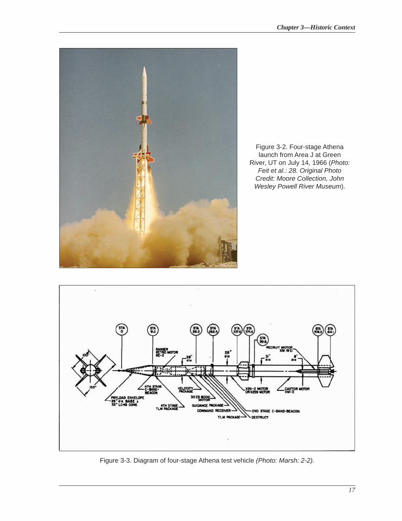
Chapter 3—Historic Context
17
Figure 3-2. Four-stage Athena launch from Area J at Green
River, UT on July 14, 1966 (Photo: Feit et al.: 28. Original Photo
Credit: Moore Collection, John Wesley Powell River Museum).
Figure 3-3. Diagram of four-stage Athena test vehicle (Photo: Marsh: 2-2).
National Register Eligibility Evaluation of the RAM and RAMPART Sites White Sands Missile Range, Otero County, New Mexico
18
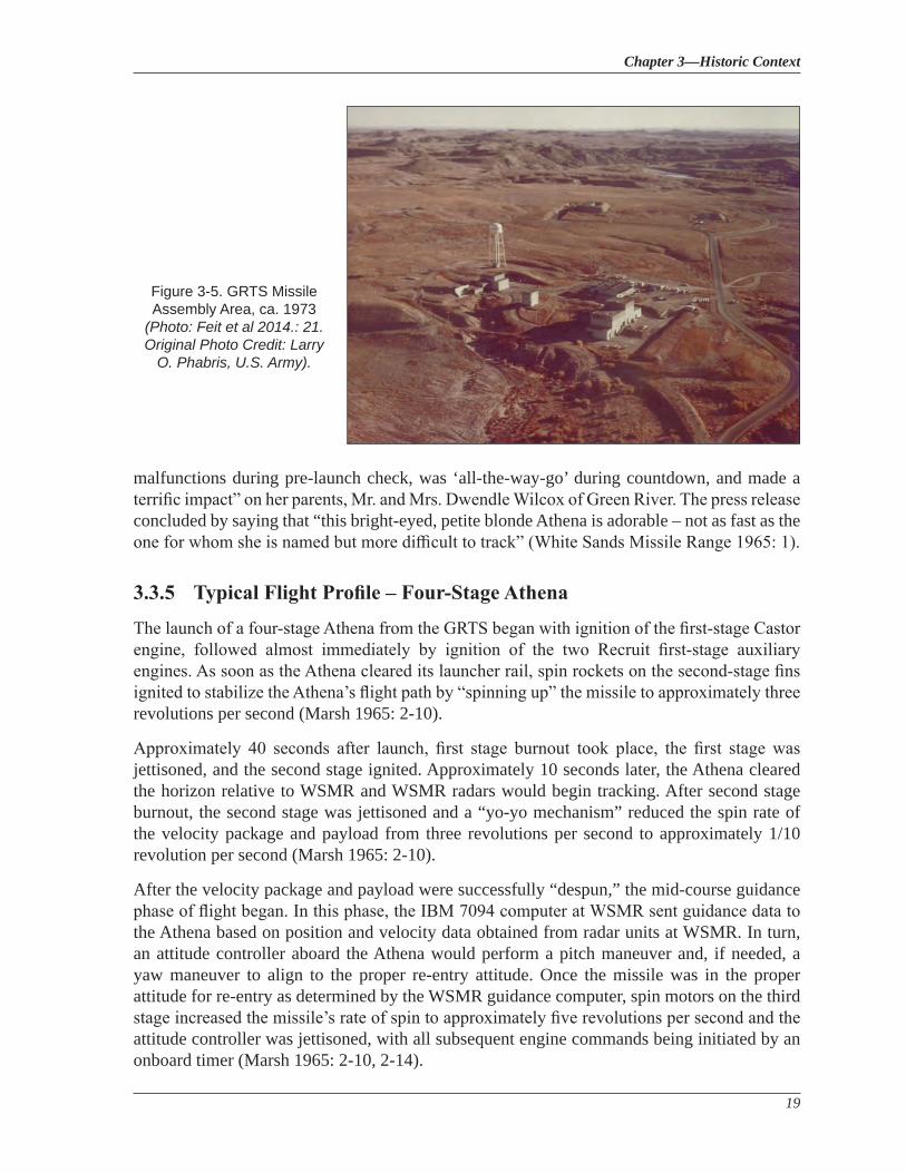
3.3.4 The Green River Test Site
The distance required for four-stage Athena launches meant that an off-range launch site would be required in order for WSMR to be used as an impact area. A team from WSMR including representatives from the USAF, ARC, Lincoln Laboratories, and the Aerospace Corporation inspected a Union Carbide Corporation uranium mining facility at Green River, Utah, a little over 400 miles from the WSMR impact area. The existing rail lines and infrastructure of the facility, combined with the area’s low population density, made the site ideal for the storage and testing of missiles and re-entry vehicle models. Placing the launch facility at Green River also opened up the possibility of extending the launch corridor to the northwest in the future, possibly as far as Washington or even Alaska. Construction of key facilities at the GRTS, also known as the Utah Launch Complex (ULC) [Figure 3-5]) began in 1963 and included a blockhouse, launch pads, a 500-foot meteorological tower, and Temperature Controlled Environmental Enclosures (TCEEs) that protected missiles from wind and weather on the launch pads when needed (Feit et al 2014.: 3, 19-23). 2
Generally, the population of the Green River area welcomed the presence of a missile launch facility in the area, thanks in part to official efforts including an active media campaign and tours of the GRTS complex for community residents. The town of Green River rebranded itself as “The Missile, Mining, and Melon capitol of the World” (Feit et al.: 22). A November 1965 Army press release discussed the first birthday of Athena Kristene Wilcox as “an Athena successfully launched at the Green River, Utah, test complex a year ago” who “registered no
2 For more information on the GRTS, see Cultural Resource Assessment of the Green River Test Site, Utah (AmaTerra Technical Report No. 71) by Rachel Feit et al 2014.
Figure 3-4. The Avco Low Observable Re-entry Vehicle (LORV) is an example of a typical payload for a four-stage Athena mission (Photo: Manevitch: 28).
Chapter 3—Historic Context
19
malfunctions during pre-launch check, was ‘all-the-way-go’ during countdown, and made a terrific impact” on her parents, Mr. and Mrs. Dwendle Wilcox of Green River. The press release concluded by saying that “this bright-eyed, petite blonde Athena is adorable – not as fast as the one for whom she is named but more difficult to track” (White Sands Missile Range 1965: 1).
3.3.5 Typical Flight Profile – Four-Stage Athena
The launch of a four-stage Athena from the GRTS began with ignition of the first-stage Castor engine, followed almost immediately by ignition of the two Recruit first-stage auxiliary engines. As soon as the Athena cleared its launcher rail, spin rockets on the second-stage fins ignited to stabilize the Athena’s flight path by “spinning up” the missile to approximately three revolutions per second (Marsh 1965: 2-10).
Approximately 40 seconds after launch, first stage burnout took place, the first stage was jettisoned, and the second stage ignited. Approximately 10 seconds later, the Athena cleared the horizon relative to WSMR and WSMR radars would begin tracking. After second stage burnout, the second stage was jettisoned and a “yo-yo mechanism” reduced the spin rate of the velocity package and payload from three revolutions per second to approximately 1/10 revolution per second (Marsh 1965: 2-10).
After the velocity package and payload were successfully “despun,” the mid-course guidance phase of flight began. In this phase, the IBM 7094 computer at WSMR sent guidance data to the Athena based on position and velocity data obtained from radar units at WSMR. In turn, an attitude controller aboard the Athena would perform a pitch maneuver and, if needed, a yaw maneuver to align to the proper re-entry attitude. Once the missile was in the proper attitude for re-entry as determined by the WSMR guidance computer, spin motors on the third stage increased the missile’s rate of spin to approximately five revolutions per second and the attitude controller was jettisoned, with all subsequent engine commands being initiated by an onboard timer (Marsh 1965: 2-10, 2-14).
Figure 3-5. GRTS Missile Assembly Area, ca. 1973
(Photo: Feit et al 2014.: 21. Original Photo Credit: Larry
O. Phabris, U.S. Army).
National Register Eligibility Evaluation of the RAM and RAMPART Sites White Sands Missile Range, Otero County, New Mexico
20
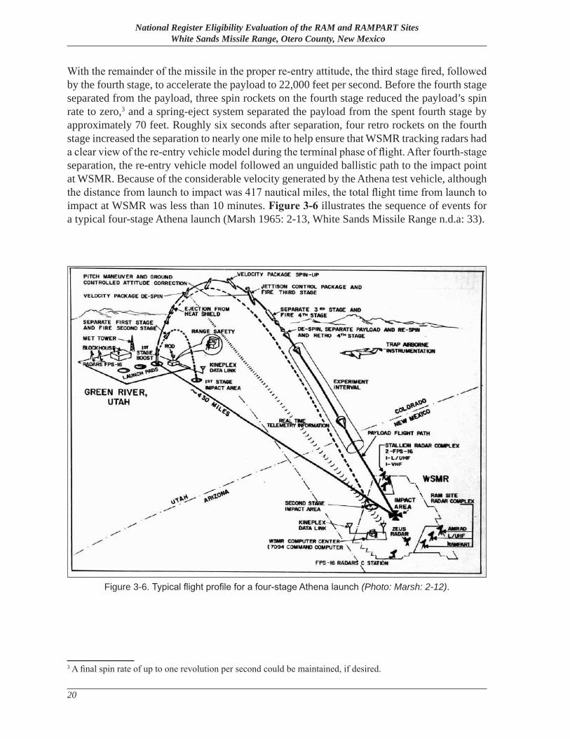
With the remainder of the missile in the proper re-entry attitude, the third stage fired, followed by the fourth stage, to accelerate the payload to 22,000 feet per second. Before the fourth stage separated from the payload, three spin rockets on the fourth stage reduced the payload’s spin rate to zero,3 and a spring-eject system separated the payload from the spent fourth stage by approximately 70 feet. Roughly six seconds after separation, four retro rockets on the fourth stage increased the separation to nearly one mile to help ensure that WSMR tracking radars had a clear view of the re-entry vehicle model during the terminal phase of flight. After fourth-stage separation, the re-entry vehicle model followed an unguided ballistic path to the impact point at WSMR. Because of the considerable velocity generated by the Athena test vehicle, although the distance from launch to impact was 417 nautical miles, the total flight time from launch to impact at WSMR was less than 10 minutes. Figure 3-6 illustrates the sequence of events for a typical four-stage Athena launch (Marsh 1965: 2-13, White Sands Missile Range n.d.a: 33).
3 A final spin rate of up to one revolution per second could be maintained, if desired.
Figure 3-6. Typical flight profile for a four-stage Athena launch (Photo: Marsh: 2-12).
Chapter 3—Historic Context
21
3.3.6 Existing Radar Facilities at WSMR Used for ABRES Missions
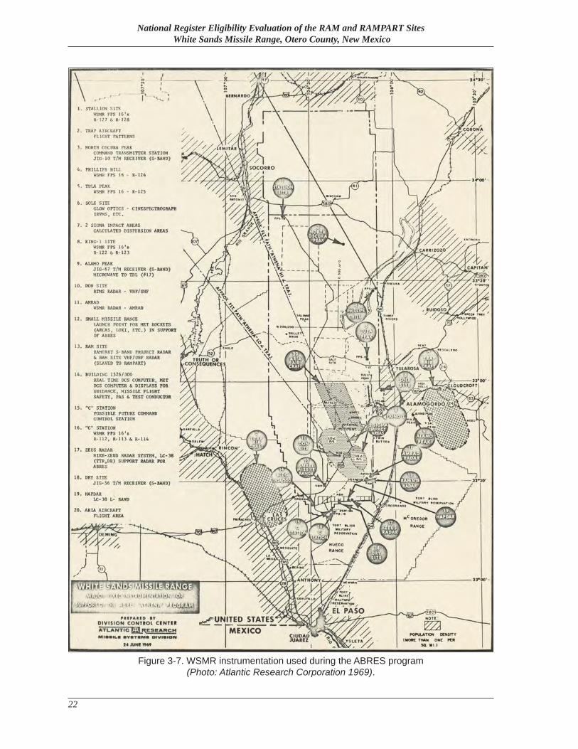
Athena payloads ended their flight from the GRTS by slamming into a predetermined impact zone in the southeast corner of WSMR at several times the speed of sound. From shortly after launch until impact, re-entry vehicle models were tracked by WSMR instrumentation including radar, optical instruments, and telemetry receivers (Figure 3-7). Although the abundance of significant tracking instruments already in place at WSMR was an important factor in WSMR’s selection to play a key role in the ABRES program, new tracking facilities were also constructed at WSMR in response to ABRES missions.
Although ABRES was an Air Force program, ABRES operations at WSMR were hailed as a multi-service effort. An October 1965 Wind & Sand article pointed out that at WSMR, Air Force personnel and contractors were manning project radar sites at an Army installation to track re-entry vehicle models that were often produced by contractors under the Navy’s direction, and that other organizations, such as the DOD’s Advanced Research Projects Agency (ARPA) and the Massachusetts Institute of Technology (MIT)’s Lincoln Laboratories, were also involved with Athena missions. The article deemed ABRES operations “a heartening mixture of the shades of blue and green” (Wind and Sand 1965a: 1).
Nike Zeus Radar SystemsThe Nike Zeus, like its predecessors Nike Ajax and Nike Hercules, was a missile designed to defend against aerial threats. However, although Ajax and Hercules were designed to destroy enemy aircraft, Zeus was designed to counter all aerial threats, including missiles. Several radar systems at WSMR that were designed and built specifically for Nike Zeus were used to track incoming Athena payloads. These radar systems included Target Tracking Radar (TTR) and Discrimination Radar (DR) units at LC-38 as well as the Multifunction Array Radar (MAR) site which was located where the High Energy Laser Systems Test Facility (HELSTF) currently stands (Eidenbach 1996: 89, Aerospace Corporation 1963: 5-10–5-11).
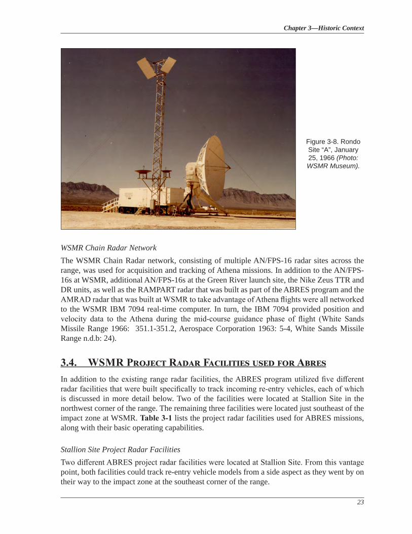
RondoThe Rondo radar system was operated by Sylvania Electronic Products Company as part of the Army’s Advanced Ballistic Missile Development Agency (ABMDA) for anti-missile defense research (Figure 3-8). Rondo consisted of three separate sites at WSMR and was unique among radar facilities because the system did not transmit its own radar energy. Instead, Rondo operated in receive-only mode and depended on other radar sites to illuminate its target with radar energy. Initially, Rondo used the TTR and DR units at LC-38 for this purpose. However, from 1970 until 1973, Rondo utilized radar energy from the Advanced Research Projects Agency Terminal (ARPAT) Measurements Radar (AMRAD) radar site (see Section 3.3.9 [White Sands Missile Range n.d.b.: 28; Wind and Sand 1970: 1]).
National Register Eligibility Evaluation of the RAM and RAMPART Sites White Sands Missile Range, Otero County, New Mexico
22
Figure 3-7. WSMR instrumentation used during the ABRES program (Photo: Atlantic Research Corporation 1969).
Chapter 3—Historic Context
23
WSMR Chain Radar NetworkThe WSMR Chain Radar network, consisting of multiple AN/FPS-16 radar sites across the range, was used for acquisition and tracking of Athena missions. In addition to the AN/FPS-16s at WSMR, additional AN/FPS-16s at the Green River launch site, the Nike Zeus TTR and DR units, as well as the RAMPART radar that was built as part of the ABRES program and the AMRAD radar that was built at WSMR to take advantage of Athena flights were all networked to the WSMR IBM 7094 real-time computer. In turn, the IBM 7094 provided position and velocity data to the Athena during the mid-course guidance phase of flight (White Sands Missile Range 1966: 351.1-351.2, Aerospace Corporation 1963: 5-4, White Sands Missile Range n.d.b: 24).
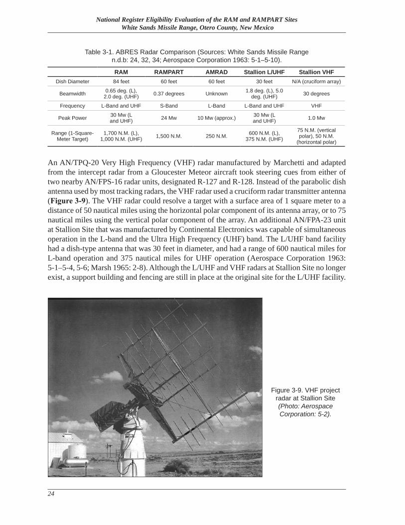
3.4. WSMR Project Radar Facilities used for AbresIn addition to the existing range radar facilities, the ABRES program utilized five different radar facilities that were built specifically to track incoming re-entry vehicles, each of which is discussed in more detail below. Two of the facilities were located at Stallion Site in the northwest corner of the range. The remaining three facilities were located just southeast of the impact zone at WSMR. Table 3-1 lists the project radar facilities used for ABRES missions, along with their basic operating capabilities.
Stallion Site Project Radar FacilitiesTwo different ABRES project radar facilities were located at Stallion Site. From this vantage point, both facilities could track re-entry vehicle models from a side aspect as they went by on their way to the impact zone at the southeast corner of the range.
Figure 3-8. Rondo Site “A”, January 25, 1966 (Photo: WSMR Museum).
National Register Eligibility Evaluation of the RAM and RAMPART Sites White Sands Missile Range, Otero County, New Mexico
24
An AN/TPQ-20 Very High Frequency (VHF) radar manufactured by Marchetti and adapted from the intercept radar from a Gloucester Meteor aircraft took steering cues from either of two nearby AN/FPS-16 radar units, designated R-127 and R-128. Instead of the parabolic dish antenna used by most tracking radars, the VHF radar used a cruciform radar transmitter antenna (Figure 3-9). The VHF radar could resolve a target with a surface area of 1 square meter to a distance of 50 nautical miles using the horizontal polar component of its antenna array, or to 75 nautical miles using the vertical polar component of the array. An additional AN/FPA-23 unit at Stallion Site that was manufactured by Continental Electronics was capable of simultaneous operation in the L-band and the Ultra High Frequency (UHF) band. The L/UHF band facility had a dish-type antenna that was 30 feet in diameter, and had a range of 600 nautical miles for L-band operation and 375 nautical miles for UHF operation (Aerospace Corporation 1963: 5-1–5-4, 5-6; Marsh 1965: 2-8). Although the L/UHF and VHF radars at Stallion Site no longer exist, a support building and fencing are still in place at the original site for the L/UHF facility.
RAM RAMPART AMRAD Stallion L/UHF Stallion VHFDish Diameter 84 feet 60 feet 60 feet 30 feet N/A (cruciform array)
Beamwidth 0.65 deg. (L), 2.0 deg. (UHF) 0.37 degrees Unknown 1.8 deg. (L), 5.0
deg. (UHF) 30 degrees
Frequency L-Band and UHF S-Band L-Band L-Band and UHF VHF
Peak Power 30 Mw (L and UHF) 24 Mw 10 Mw (approx.) 30 Mw (L
and UHF) 1.0 Mw
Range (1-Square-Meter Target)
1,700 N.M. (L), 1,000 N.M. (UHF) 1,500 N.M. 250 N.M. 600 N.M. (L),
375 N.M. (UHF)75 N.M. (vertical polar), 50 N.M.
(horizontal polar)
Table 3-1. ABRES Radar Comparison (Sources: White Sands Missile Range n.d.b: 24, 32, 34; Aerospace Corporation 1963: 5-1–5-10).
Figure 3-9. VHF project radar at Stallion Site (Photo: Aerospace Corporation: 5-2).
Chapter 3—Historic Context
25
3.4.1 Radar Advanced Measurements Program for Analysis of Re-entry Techniques (RAMPART)
Although the AN/FPS-62(XW-1) RAMPART radar became the prime sensor for the Air Force’s ABRES program, the system’s foundation was an earlier ARPA-developed radar known as Pincushion. When it was formed in 1958 after the U.S.S.R.’s successful launch of both an ICBM and the world’s first orbital satellite, ARPA’s main program, known as Project DEFENDER, sought the means to distinguish between ICBM warheads and the accompanying debris created by the upper stage of an ICBM, as well as any decoys or countermeasures employed by the warhead. One component of Project DEFENDER was the Pacific Range Electromagnetic Signature Study (PRESS), which was established on Roi-Namur Island, Kwajalein Atoll. Pincushion, which was one of the radar facilities envisioned for PRESS, was initially intended to be an S-band radar using multiple-beam techniques to develop procedures to track ballistic missiles and distinguish valid targets from decoys. The Raytheon Company was given a contract to develop Pincushion in October 1959, but in 1960 PRESS’s objectives were changed to focus on tracking targets during re-entry rather than outside the atmosphere. Because of this change in focus, Pincushion was removed from the PRESS program. However, Raytheon continued to develop the Pincushion system until late 1960 when Raytheon “was formally notified…to reduce all Pincushion effort to the minimum level necessary to complete the development on an austere basis” (Ingwersen and Lemnios 2000: 245, Marsh 1965: 1-1–1-2).
In February 1961, Raytheon’s contract for Pincushion was changed to allow the company to manufacture the radar’s major components and subsystems, including display and control consoles, a transmitter chain, and the pedestal/servo system. After check-out and government acceptance tests of the completed Pincushion components, the equipment was placed into storage in Massachusetts and New Jersey (Marsh 1965: 1-1–1-2).
In March 1962, the Air Force contracted with Raytheon to develop and install the RAMPART radar system, and to operate the system for one year. The terms of the contract specified that “maximum utilization would be made of subsystems and components developed under the…Pincushion system” (Marsh: 1-2). With the establishment of the ABRES program, RAMPART was designated as the prime sensor of the program and assigned the following three objectives:
a) Provide fine-grain payload signature characteristics at mid-S-band frequency.
b) Provide target designation to other ABRES radars throughout the missile trajectory with special emphasis on the critical time of payload separation when other ABRES tracking radars would be power limited.
c) Provide continuous angle, range, and pulse repetition frequency (PRF) slaving data to those non-tracking ABRES radars slaved directly to RAMPART (Marsh 1965: 1-3).
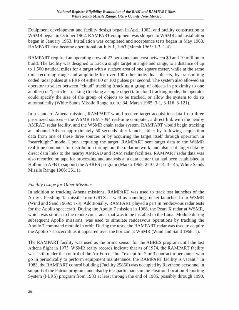
National Register Eligibility Evaluation of the RAM and RAMPART Sites White Sands Missile Range, Otero County, New Mexico
26
Equipment development and facility design began in April 1962, and facility construction at WSMR began in October 1962. RAMPART equipment was shipped to WSMR and installation began in January 1963. Installation was completed and acceptance tests began in May 1963. RAMPART first became operational on July 1, 1963 (Marsh 1965: 1-3–1-4).
RAMPART required an operating crew of 23 personnel and cost between $9 and 10 million to build. The facility was designed to track a single target in angle and range, to a distance of up to 1,500 nautical miles for a target with a surface area of one square meter, while at the same time recording range and amplitude for over 100 other individual objects, by transmitting coded radar pulses at a PRF of either 80 or 100 pulses per second. The system also allowed an operator to select between “cloud” tracking (tracking a group of objects in proximity to one another) or “particle” tracking (tracking a single object). In cloud tracking mode, the operator could specify the size of the group of objects to be tracked, or allow the system to do so automatically (White Sands Missile Range n.d.b.: 34; Marsh 1965: 3-1, 3-116–3-121).
In a standard Athena mission, RAMPART would receive target acquisition data from three prioritized sources – the WSMR IBM 7094 real-time computer, a direct link with the nearby AMRAD radar facility, and the WSMR chain radar system. RAMPART would begin tracking an inbound Athena approximately 50 seconds after launch, either by following acquisition data from one of these three sources or by acquiring the target itself through operation in “searchlight” mode. Upon acquiring the target, RAMPART sent target data to the WSMR real-time computer for distribution throughout the radar network, and also sent target data by direct data links to the nearby AMRAD and RAM radar facilities. RAMPART radar data was also recorded on tape for processing and analysis at a data center that had been established at Holloman AFB to support the ABRES program (Marsh 1965: 2-10, 2-14, 3-145; White Sands Missile Range 1966: 351.1).
Facility Usage for Other MissionsIn addition to tracking Athena missions, RAMPART was used to track test launches of the Army’s Pershing 1a missile from GRTS as well as sounding rocket launches from WSMR (Wind and Sand 1969c: 1-3). Additionally, RAMPART played a part in rendezvous radar tests for the Apollo spacecraft. During the Apollo 7 mission in 1968, the Pearl X radar at WSMR, which was similar to the rendezvous radar that was to be installed in the Lunar Module during subsequent Apollo missions, was used to simulate rendezvous operations by tracking the Apollo 7 command module in orbit. During the tests, the RAMPART radar was used to acquire the Apollo 7 spacecraft as it appeared over the horizon at WSMR (Wind and Sand 1968: 1).
The RAMPART facility was used as the prime sensor for the ABRES program until the last Athena flight in 1973. WSMR realty records indicate that as of 1974, the RAMPART facility was “still under the control of the Air Force,” but “except for 2 or 3 contractor personnel who go in periodically to perform equipment maintenance, the RAMPART facility is vacant.” In 1983, the RAMPART control building (Facility 25850) was occupied by Raytheon personnel in support of the Patriot program, and also by test participants in the Position Location Reporting System (PLRS) program from 1983 at least through the end of 1985, possibly through 1990,
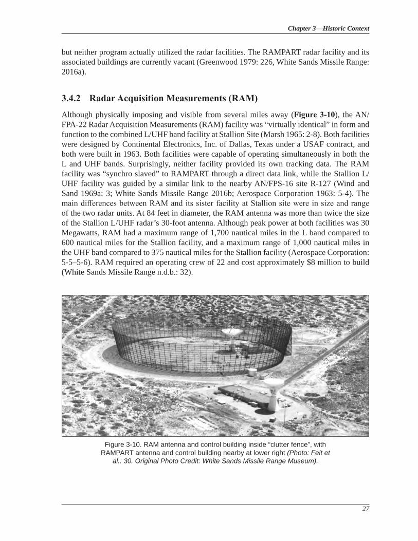
Chapter 3—Historic Context
27
but neither program actually utilized the radar facilities. The RAMPART radar facility and its associated buildings are currently vacant (Greenwood 1979: 226, White Sands Missile Range: 2016a).
3.4.2 Radar Acquisition Measurements (RAM)
Although physically imposing and visible from several miles away (Figure 3-10), the AN/FPA-22 Radar Acquisition Measurements (RAM) facility was “virtually identical” in form and function to the combined L/UHF band facility at Stallion Site (Marsh 1965: 2-8). Both facilities were designed by Continental Electronics, Inc. of Dallas, Texas under a USAF contract, and both were built in 1963. Both facilities were capable of operating simultaneously in both the L and UHF bands. Surprisingly, neither facility provided its own tracking data. The RAM facility was “synchro slaved” to RAMPART through a direct data link, while the Stallion L/UHF facility was guided by a similar link to the nearby AN/FPS-16 site R-127 (Wind and Sand 1969a: 3; White Sands Missile Range 2016b; Aerospace Corporation 1963: 5-4). The main differences between RAM and its sister facility at Stallion site were in size and range of the two radar units. At 84 feet in diameter, the RAM antenna was more than twice the size of the Stallion L/UHF radar’s 30-foot antenna. Although peak power at both facilities was 30 Megawatts, RAM had a maximum range of 1,700 nautical miles in the L band compared to 600 nautical miles for the Stallion facility, and a maximum range of 1,000 nautical miles in the UHF band compared to 375 nautical miles for the Stallion facility (Aerospace Corporation: 5-5–5-6). RAM required an operating crew of 22 and cost approximately $8 million to build (White Sands Missile Range n.d.b.: 32).
Figure 3-10. RAM antenna and control building inside “clutter fence”, with RAMPART antenna and control building nearby at lower right (Photo: Feit et
al.: 30. Original Photo Credit: White Sands Missile Range Museum).
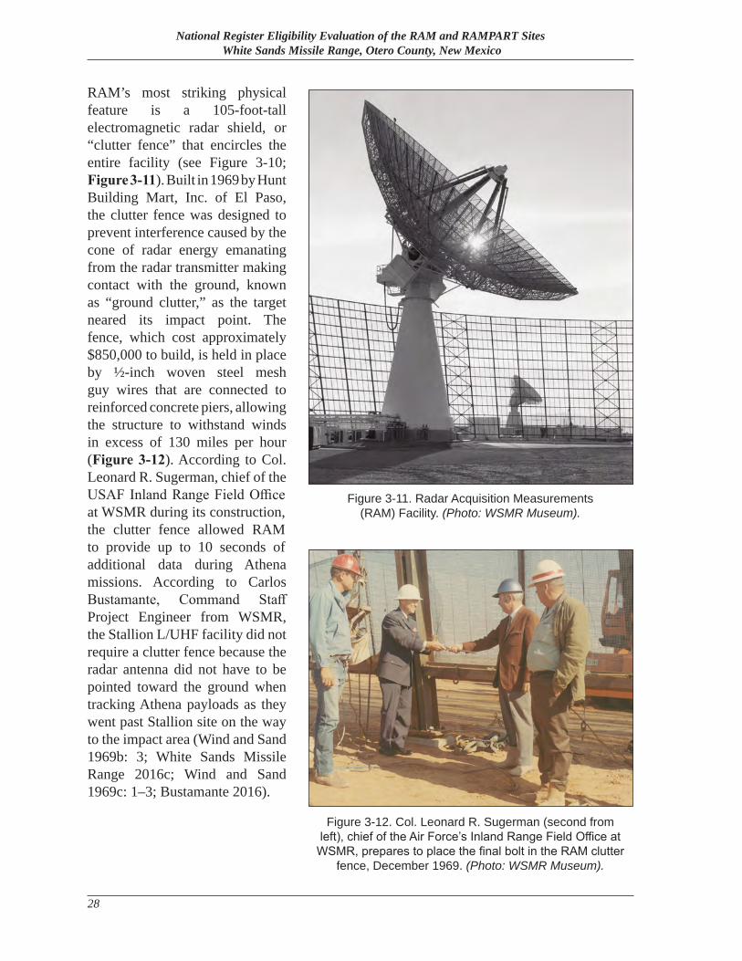
National Register Eligibility Evaluation of the RAM and RAMPART Sites White Sands Missile Range, Otero County, New Mexico
28
RAM’s most striking physical feature is a 105-foot-tall electromagnetic radar shield, or “clutter fence” that encircles the entire facility (see Figure 3-10; Figure 3-11). Built in 1969 by Hunt Building Mart, Inc. of El Paso, the clutter fence was designed to prevent interference caused by the cone of radar energy emanating from the radar transmitter making contact with the ground, known as “ground clutter,” as the target neared its impact point. The fence, which cost approximately $850,000 to build, is held in place by ½-inch woven steel mesh guy wires that are connected to reinforced concrete piers, allowing the structure to withstand winds in excess of 130 miles per hour (Figure 3-12). According to Col. Leonard R. Sugerman, chief of the USAF Inland Range Field Office at WSMR during its construction, the clutter fence allowed RAM to provide up to 10 seconds of additional data during Athena missions. According to Carlos Bustamante, Command Staff Project Engineer from WSMR, the Stallion L/UHF facility did not require a clutter fence because the radar antenna did not have to be pointed toward the ground when tracking Athena payloads as they went past Stallion site on the way to the impact area (Wind and Sand 1969b: 3; White Sands Missile Range 2016c; Wind and Sand 1969c: 1–3; Bustamante 2016).
Figure 3-12. Col. Leonard R. Sugerman (second from left), chief of the Air Force’s Inland Range Field Office at
WSMR, prepares to place the final bolt in the RAM clutter fence, December 1969. (Photo: WSMR Museum).
Figure 3-11. Radar Acquisition Measurements (RAM) Facility. (Photo: WSMR Museum).
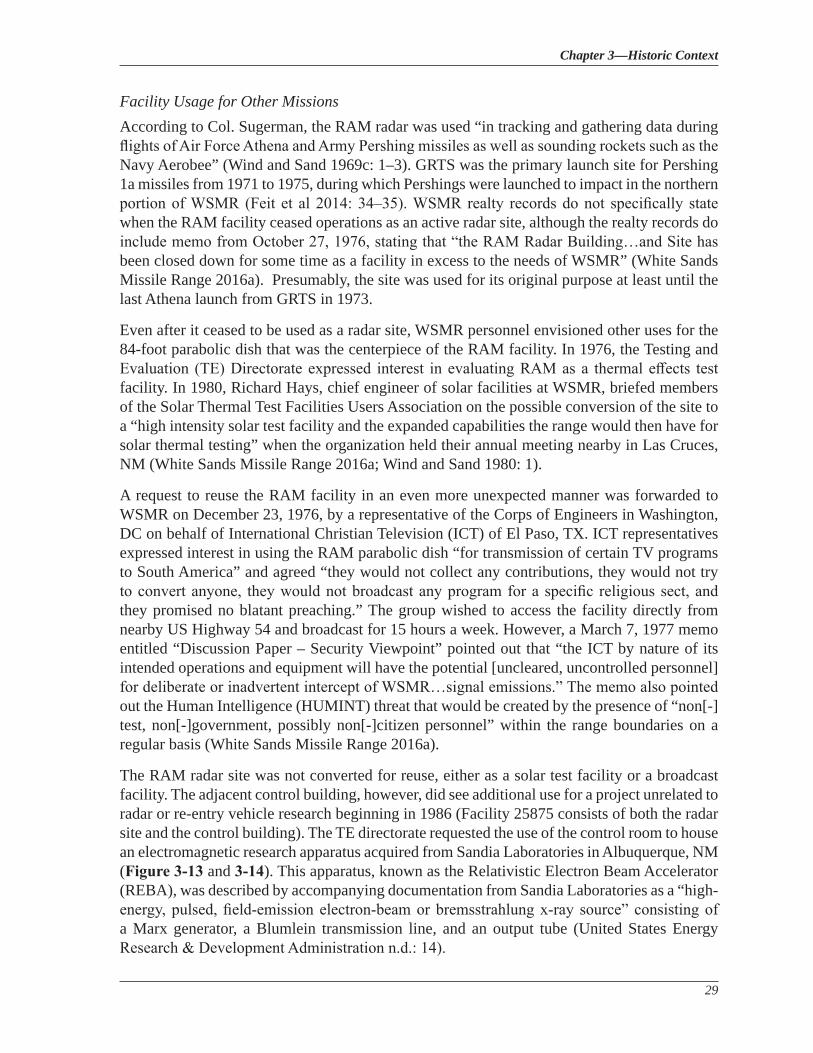
Chapter 3—Historic Context
29
Facility Usage for Other MissionsAccording to Col. Sugerman, the RAM radar was used “in tracking and gathering data during flights of Air Force Athena and Army Pershing missiles as well as sounding rockets such as the Navy Aerobee” (Wind and Sand 1969c: 1–3). GRTS was the primary launch site for Pershing 1a missiles from 1971 to 1975, during which Pershings were launched to impact in the northern portion of WSMR (Feit et al 2014: 34–35). WSMR realty records do not specifically state when the RAM facility ceased operations as an active radar site, although the realty records do include memo from October 27, 1976, stating that “the RAM Radar Building…and Site has been closed down for some time as a facility in excess to the needs of WSMR” (White Sands Missile Range 2016a). Presumably, the site was used for its original purpose at least until the last Athena launch from GRTS in 1973.
Even after it ceased to be used as a radar site, WSMR personnel envisioned other uses for the 84-foot parabolic dish that was the centerpiece of the RAM facility. In 1976, the Testing and Evaluation (TE) Directorate expressed interest in evaluating RAM as a thermal effects test facility. In 1980, Richard Hays, chief engineer of solar facilities at WSMR, briefed members of the Solar Thermal Test Facilities Users Association on the possible conversion of the site to a “high intensity solar test facility and the expanded capabilities the range would then have for solar thermal testing” when the organization held their annual meeting nearby in Las Cruces, NM (White Sands Missile Range 2016a; Wind and Sand 1980: 1).
A request to reuse the RAM facility in an even more unexpected manner was forwarded to WSMR on December 23, 1976, by a representative of the Corps of Engineers in Washington, DC on behalf of International Christian Television (ICT) of El Paso, TX. ICT representatives expressed interest in using the RAM parabolic dish “for transmission of certain TV programs to South America” and agreed “they would not collect any contributions, they would not try to convert anyone, they would not broadcast any program for a specific religious sect, and they promised no blatant preaching.” The group wished to access the facility directly from nearby US Highway 54 and broadcast for 15 hours a week. However, a March 7, 1977 memo entitled “Discussion Paper – Security Viewpoint” pointed out that “the ICT by nature of its intended operations and equipment will have the potential [uncleared, uncontrolled personnel] for deliberate or inadvertent intercept of WSMR…signal emissions.” The memo also pointed out the Human Intelligence (HUMINT) threat that would be created by the presence of “non[-]test, non[-]government, possibly non[-]citizen personnel” within the range boundaries on a regular basis (White Sands Missile Range 2016a).
The RAM radar site was not converted for reuse, either as a solar test facility or a broadcast facility. The adjacent control building, however, did see additional use for a project unrelated to radar or re-entry vehicle research beginning in 1986 (Facility 25875 consists of both the radar site and the control building). The TE directorate requested the use of the control room to house an electromagnetic research apparatus acquired from Sandia Laboratories in Albuquerque, NM (Figure 3-13 and 3-14). This apparatus, known as the Relativistic Electron Beam Accelerator (REBA), was described by accompanying documentation from Sandia Laboratories as a “high-energy, pulsed, field-emission electron-beam or bremsstrahlung x-ray source” consisting of a Marx generator, a Blumlein transmission line, and an output tube (United States Energy Research & Development Administration n.d.: 14).
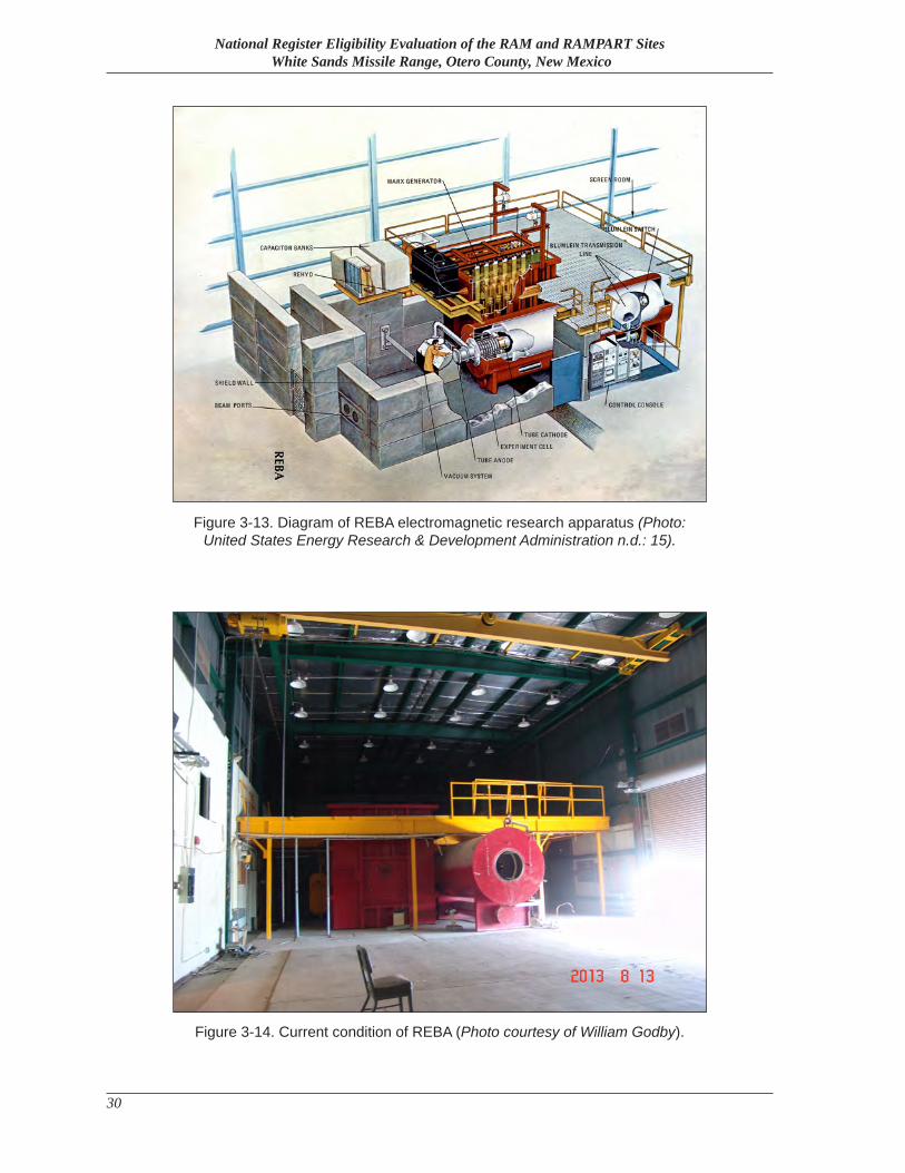
National Register Eligibility Evaluation of the RAM and RAMPART Sites White Sands Missile Range, Otero County, New Mexico
30
Figure 3-13. Diagram of REBA electromagnetic research apparatus (Photo: United States Energy Research & Development Administration n.d.: 15).
Figure 3-14. Current condition of REBA (Photo courtesy of William Godby).
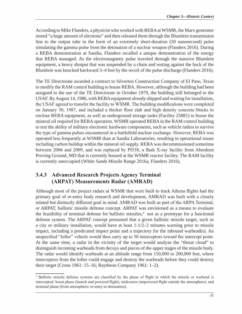
Chapter 3—Historic Context
31
According to Mike Flanders, a physicist who worked with REBA at WSMR, the Marx generator stored “a huge amount of electrons” and then released them through the Blumlein transmission line to the output tube in the form of an extremely short-duration (50 nanosecond) pulse simulating the gamma pulse from the detonation of a nuclear weapon (Flanders 2016). During a REBA demonstration at Sandia, Flanders recalled a unique demonstration of the energy that REBA managed. As the electromagnetic pulse traveled through the massive Blumlein equipment, a heavy shotput that was suspended by a chain and resting against the back of the Blumlein was knocked backward 3–4 feet by the recoil of the pulse discharge (Flanders 2016).
The TE Directorate awarded a contract to Silverton Construction Company of El Paso, Texas to modify the RAM control building to house REBA. However, although the building had been assigned to the use of the TE Directorate in October 1979, the building still belonged to the USAF. By August 14, 1986, with REBA equipment already shipped and waiting for installation, the USAF agreed to transfer the facility to WSMR. The building modifications were completed on January 30, 1987, and included a thicker floor slab and high density concrete blocks to enclose REBA equipment, as well as underground storage tanks (Facility 25881) to house the mineral oil required for REBA operation. WSMR operated REBA in the RAM control building to test the ability of military electronic hardware components, such as vehicle radios to survive the type of gamma pulses encountered in a battlefield nuclear exchange. However, REBA was operated less frequently at WSMR than at Sandia Laboratories, resulting in operational issues including carbon buildup within the mineral oil supply. REBA was decommissioned sometime between 2006 and 2009, and was replaced by PI538, a flash X-ray facility from Aberdeen Proving Ground, MD that is currently housed at the WSMR reactor facility. The RAM facility is currently unoccupied (White Sands Missile Range 2016a, Flanders 2016).
3.4.3 Advanced Research Projects Agency Terminal (ARPAT) Measurements Radar (AMRAD)
Although most of the project radars at WSMR that were built to track Athena flights had the primary goal of re-entry body research and development, AMRAD was built with a closely related but distinctly different goal in mind. AMRAD was built as part of the ARPA Terminal, or ARPAT, ballistic missile defense concept. ARPAT was envisioned as a means to evaluate the feasibility of terminal defense for ballistic missiles,4 not as a prototype for a functional defense system. The ARPAT concept presumed that a given ballistic missile target, such as a city or military installation, would have at least 1-1/2–2 minutes warning prior to missile impact, including a predicated impact point and a trajectory for the inbound warhead(s). An unspecified “lofter” vehicle would then carry up to 50 interceptors toward the intercept point. At the same time, a radar in the vicinity of the target would analyze the “threat cloud” to distinguish incoming warheads from decoys and pieces of the upper stages of the missile body. The radar would identify warheads at an altitude range from 150,000 to 200,000 feet, where interceptors from the lofter could engage and destroy the warheads before they could destroy their target (Crone 1961: 15–16; Raytheon Company 1961: 1–2).
4 Ballistic missile defense systems are classified by the phase of flight in which the missile or warhead is intercepted: boost phase (launch and powered flight), midcourse (unpowered flight outside the atmosphere), and terminal phase (from atmospheric re-entry to detonation).
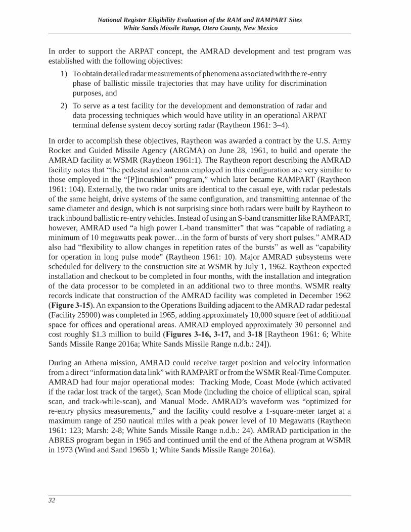
National Register Eligibility Evaluation of the RAM and RAMPART Sites White Sands Missile Range, Otero County, New Mexico
32
In order to support the ARPAT concept, the AMRAD development and test program was established with the following objectives:
1) To obtain detailed radar measurements of phenomena associated with the re-entry phase of ballistic missile trajectories that may have utility for discrimination purposes, and
2) To serve as a test facility for the development and demonstration of radar and data processing techniques which would have utility in an operational ARPAT terminal defense system decoy sorting radar (Raytheon 1961: 3–4).
In order to accomplish these objectives, Raytheon was awarded a contract by the U.S. Army Rocket and Guided Missile Agency (ARGMA) on June 28, 1961, to build and operate the AMRAD facility at WSMR (Raytheon 1961:1). The Raytheon report describing the AMRAD facility notes that “the pedestal and antenna employed in this configuration are very similar to those employed in the “[P]incushion” program,” which later became RAMPART (Raytheon 1961: 104). Externally, the two radar units are identical to the casual eye, with radar pedestals of the same height, drive systems of the same configuration, and transmitting antennae of the same diameter and design, which is not surprising since both radars were built by Raytheon to track inbound ballistic re-entry vehicles. Instead of using an S-band transmitter like RAMPART, however, AMRAD used “a high power L-band transmitter” that was “capable of radiating a minimum of 10 megawatts peak power…in the form of bursts of very short pulses.” AMRAD also had “flexibility to allow changes in repetition rates of the bursts” as well as “capability for operation in long pulse mode” (Raytheon 1961: 10). Major AMRAD subsystems were scheduled for delivery to the construction site at WSMR by July 1, 1962. Raytheon expected installation and checkout to be completed in four months, with the installation and integration of the data processor to be completed in an additional two to three months. WSMR realty records indicate that construction of the AMRAD facility was completed in December 1962 (Figure 3-15). An expansion to the Operations Building adjacent to the AMRAD radar pedestal (Facility 25900) was completed in 1965, adding approximately 10,000 square feet of additional space for offices and operational areas. AMRAD employed approximately 30 personnel and cost roughly $1.3 million to build (Figures 3-16, 3-17, and 3-18 [Raytheon 1961: 6; White Sands Missile Range 2016a; White Sands Missile Range n.d.b.: 24]).
During an Athena mission, AMRAD could receive target position and velocity information from a direct “information data link” with RAMPART or from the WSMR Real-Time Computer. AMRAD had four major operational modes: Tracking Mode, Coast Mode (which activated if the radar lost track of the target), Scan Mode (including the choice of elliptical scan, spiral scan, and track-while-scan), and Manual Mode. AMRAD’s waveform was “optimized for re-entry physics measurements,” and the facility could resolve a 1-square-meter target at a maximum range of 250 nautical miles with a peak power level of 10 Megawatts (Raytheon 1961: 123; Marsh: 2-8; White Sands Missile Range n.d.b.: 24). AMRAD participation in the ABRES program began in 1965 and continued until the end of the Athena program at WSMR in 1973 (Wind and Sand 1965b 1; White Sands Missile Range 2016a).
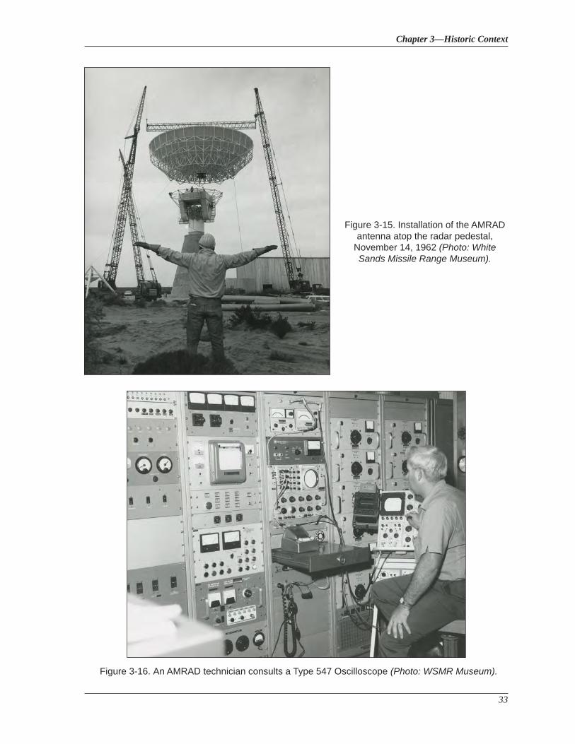
Chapter 3—Historic Context
33
Figure 3-15. Installation of the AMRAD antenna atop the radar pedestal,
November 14, 1962 (Photo: White Sands Missile Range Museum).
Figure 3-16. An AMRAD technician consults a Type 547 Oscilloscope (Photo: WSMR Museum).
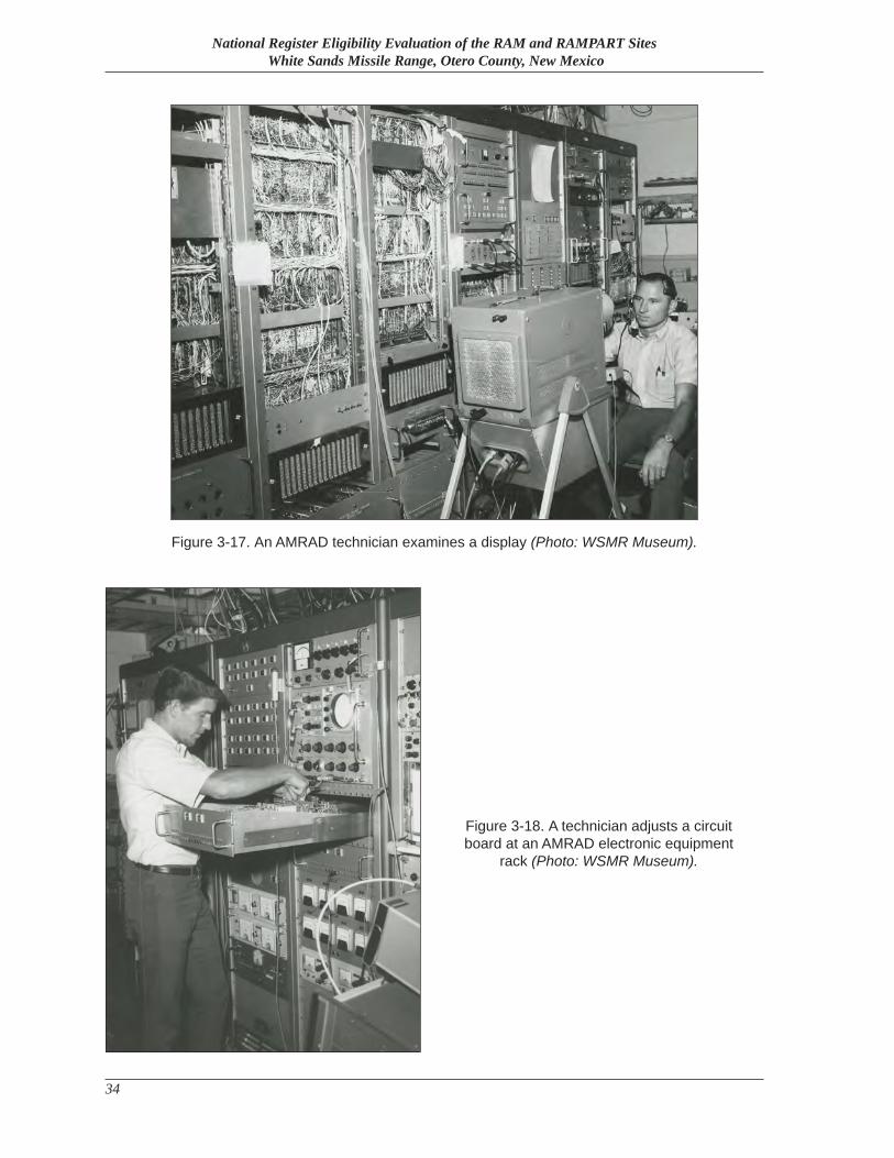
National Register Eligibility Evaluation of the RAM and RAMPART Sites White Sands Missile Range, Otero County, New Mexico
34
Figure 3-18. A technician adjusts a circuit board at an AMRAD electronic equipment
rack (Photo: WSMR Museum).
Figure 3-17. An AMRAD technician examines a display (Photo: WSMR Museum).
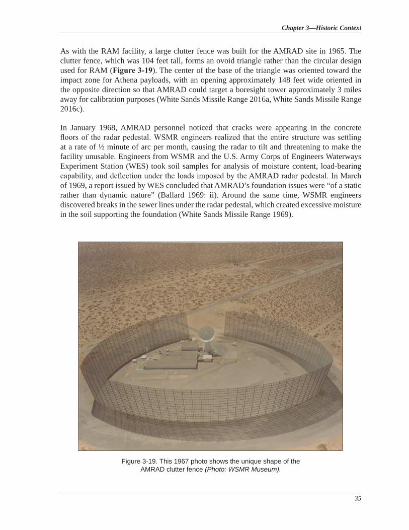
Chapter 3—Historic Context
35
As with the RAM facility, a large clutter fence was built for the AMRAD site in 1965. The clutter fence, which was 104 feet tall, forms an ovoid triangle rather than the circular design used for RAM (Figure 3-19). The center of the base of the triangle was oriented toward the impact zone for Athena payloads, with an opening approximately 148 feet wide oriented in the opposite direction so that AMRAD could target a boresight tower approximately 3 miles away for calibration purposes (White Sands Missile Range 2016a, White Sands Missile Range 2016c).
In January 1968, AMRAD personnel noticed that cracks were appearing in the concrete floors of the radar pedestal. WSMR engineers realized that the entire structure was settling at a rate of ½ minute of arc per month, causing the radar to tilt and threatening to make the facility unusable. Engineers from WSMR and the U.S. Army Corps of Engineers Waterways Experiment Station (WES) took soil samples for analysis of moisture content, load-bearing capability, and deflection under the loads imposed by the AMRAD radar pedestal. In March of 1969, a report issued by WES concluded that AMRAD’s foundation issues were “of a static rather than dynamic nature” (Ballard 1969: ii). Around the same time, WSMR engineers discovered breaks in the sewer lines under the radar pedestal, which created excessive moisture in the soil supporting the foundation (White Sands Missile Range 1969).
Figure 3-19. This 1967 photo shows the unique shape of the AMRAD clutter fence (Photo: WSMR Museum).
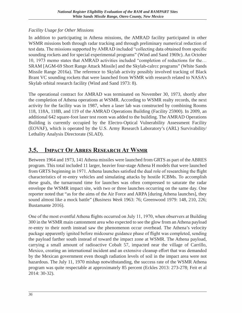
National Register Eligibility Evaluation of the RAM and RAMPART Sites White Sands Missile Range, Otero County, New Mexico
36
Facility Usage for Other MissionsIn addition to participating in Athena missions, the AMRAD facility participated in other WSMR missions both through radar tracking and through preliminary numerical reduction of test data. The missions supported by AMRAD included “collecting data obtained from specific sounding rockets and for special experimental programs” (Wind and Sand 1969c). An October 10, 1973 memo states that AMRAD activities included “completion of reductions for the…SRAM [AGM-69 Short Range Attack Missile] and the Skylab-calrcc programs” (White Sands Missile Range 2016a). The reference to Skylab activity possibly involved tracking of Black Brant VC sounding rockets that were launched from WSMR with research related to NASA’s Skylab orbital research facility (Wind and Sand 1973: 8).
The operational contract for AMRAD was terminated on November 30, 1973, shortly after the completion of Athena operations at WSMR. According to WSMR realty records, the next activity for the facility was in 1987, when a laser lab was constructed by combining Rooms 118, 118A, 118B, and 119 of the AMRAD Operations Building (Facility 25900). In 2009, an additional 642 square-foot laser test room was added to the building. The AMRAD Operations Building is currently occupied by the Electro-Optical Vulnerability Assessment Facility (EOVAF), which is operated by the U.S. Army Research Laboratory’s (ARL) Survivability/Lethality Analysis Directorate (SLAD).
3.5. Impact Of Abres Research At WsmrBetween 1964 and 1973, 141 Athena missiles were launched from GRTS as part of the ABRES program. This total included 11 larger, heavier four-stage Athena H models that were launched from GRTS beginning in 1971. Athena launches satisfied the dual role of researching the flight characteristics of re-entry vehicles and simulating attacks by hostile ICBMs. To accomplish these goals, the turnaround time for launches was often compressed to saturate the radar envelope the WSMR impact site, with two or three launches occurring on the same day. One reporter noted that “as for the aims of the Air Force and ARPA [during Athena launches], they sound almost like a mock battle” (Business Week 1963: 76; Greenwood 1979: 148, 210, 226; Bustamante 2016).
One of the most eventful Athena flights occurred on July 11, 1970, when observers at Building 300 in the WSMR main cantonment area who expected to see the glow from an Athena payload re-entry to their north instead saw the phenomenon occur overhead. The Athena’s velocity package apparently ignited before midcourse guidance phase of flight was completed, sending the payload farther south instead of toward the impact zone at WSMR. The Athena payload, carrying a small amount of radioactive Cobalt 57, impacted near the village of Carrillo, Mexico, creating an international incident and an extensive cleanup effort that was demanded by the Mexican government even though radiation levels of soil in the impact area were not hazardous. The July 11, 1970 mishap notwithstanding, the success rate of the WSMR Athena program was quite respectable at approximately 85 percent (Eckles 2013: 273-278; Feit et al 2014: 30-32).
Chapter 3—Historic Context
37
Although the concept of terminal ICBM defense that was envisioned with the ARPAT project proved to be beyond the technical capabilities of the period, the data that was generated by the RAMPART, RAM, and AMRAD facilities from tracking Athena payloads proved invaluable for the development of ICBM re-entry vehicles as well as countermeasures to ensure the survivability of ICBM payloads. ABRES-generated data on re-entry angles and re-entry vehicle technology was applied to the development of several ICBM systems. Perhaps the best validation of the ABRES program was the deployment of the LGM-30 Minuteman III ICBM in 1970, the development of which relied heavily on ABRES-based innovations. The year before its deployment, the commander of SAMSO described the Minuteman III as “so greatly improved in its capabilities that it is as different from the original Minuteman I as the F-111 aircraft is from the P-51 of World War II fame” (O’Neill 1969: 1-5). The Minuteman III utilized several advances that were developed from ABRES research, most notably the first deployment of Multiple Independently-Targeted Re-entry Vehicles (MIRVs), allowing each Minuteman III to target up to three geographically separated targets.5 Although it is now over 40 years old, not only is the Minuteman III still in use, it is the only land-based ICBM in service in the U.S. (United States Air Force 2015; globalsecurity.org 2016).
5 To comply with arms reduction treaty requirements, all Minuteman IIIs were “deMIRVed” or reduced to a single warhead in 2014 (Great Falls Tribune 2014: 1).

National Register Eligibility Evaluation of the RAM and RAMPART Sites White Sands Missile Range, Otero County, New Mexico
38
Chapter 4—Methodology
39
Chapter 4
Methodology
4.1. Pre-Field Research and Consulted Background DocumentsIn preparation for field survey, background historic research of the RAM and RAMPART sites was conducted using various networked research resources available at Building 163, Cultural Resources Branch of the Environmental Division of WSMR’s Directorate of Public Works. Additional research was conducted at the WSMR museum.
The following source materials were consulted and relevant documentation compiled:
• White Sands Missile Range Geographic Information System data. • 1963 White Sands Missile Range Master Plan Maps Illustrating RAM and RAMPART
buildings and structures. • 1982 White Sands Missile Range General Site Map, demonstrating facility numbers
associated with RAM and RAMPART. • The White Sands Missile Range Historic Newspaper Digital Archive. • 1963 White Sands Missile Range Facilities Utilization Report for RAM and RAMPART
facilities. • White Sands Missile Range Facility Databases, aka “Giblin Building Data” for RAM
and RAMPART facility numbers and building data, and the “Revised Building Update” database.
• Historic images of RAM and RAMPART facilities, located at WSMR Directorate of Public Works.
• Previous RAM and RAMPART Field Survey Data: ♦ 1996a Human Systems Research (HSR) survey report for RAM facilities (HSR Project No.
9422). ♦ 1996b HSR survey report for RAMPART facilities (HSR Project No. 9422).
• White Sands Missile Range Scanned Drawer Drawings for RAM and RAMPART facilities, located at the WSMR Directorate of Public Works:
♦ Drawing 61010 showing RAM radar equipment shelter, Drawing WS-LY showing RAM radar equipment shelter addition, Drawing B-37550 showing 1970 alterations to RAM and RAMPART radar facilities, Drawing WS-KS-1A showing 1986 REBA modifications to RAM facilities, Drawing AL-X-242 showing the RAM and RAMPART fire protection and water storage systems, Drawing WS-QS showing as-built drawings for the RAM Clutter Shield, and Drawing WS-KS showing as-built drawings for RAMPART facilities.
National Register Eligibility Evaluation of the RAM and RAMPART Sites White Sands Missile Range, Otero County, New Mexico
40
4.2. Field SurveyField work was conducted in July of 2016 by a historian who examined above-ground buildings and structures for evidence of site development and alterations. Previous survey documentation and historic maps and photographs were used during field work to chart changes to the historic landscape.
For each building, photographs included at least a single view of each elevation, followed by at least one oblique view and an overview image of the building in its broader setting within the landscape, as well as its relationship to other buildings and structures. Signage and character-defining architectural features were photographed. Field notes were maintained to note architectural features and to record research questions generated during field survey.
4.3. Significance Evaluation MethodologyThe NRHP has established four criteria (A–D) which guide the evaluation and eligibility of potential entries to the NRHP. National Park Service Bulletin 15 explains the four criteria and their application to determine if a property is or is not eligible for the National Register.
Criterion A is used to evaluate resources that are associated with events that have made significant contribution to the broad patterns of U.S. history. In order for a property to be eligible for Criterion A, it must be significant under at least one defined historic context and it must convey a sense of the past and remain recognizable to the period in which it was first constructed or achieved significance.
Criterion B applies to resources associated with individuals whose specific contributions to U.S. history can be identified and documented, and which are directly related to the resource.
Criterion C is applied to resources which derive significance from the physical qualities of their design, construction, and/or craftsmanship, including such elements as architecture, landscape architecture, engineering, and art. Eligible properties under Criterion C must embody distinctive characteristics of a type, period, or method of construction; represent the work of a master; possess high artistic value; or represent a significant and distinguishable entity whose components may lack individual distinction, exemplified as contributing resources to an historic district. Such a property must also retain a high degree of physical integrity, as well as having a relation to the historic context.
Criterion D is applied most often to archeological resources. Properties significant under this Criterion are those that have the ability to contribute to the understanding of human history or prehistory. Criterion D may occasionally be applicable to buildings, as a rare type of construction with little other known applicable documentation. Under this application, the buildings, structures or objects in question must themselves be the principal source of the important information, and this information must be considered “important.” Information is considered important when it is shown to have significant bearing on the research design, such as closing data gaps.
Chapter 4—Methodology
41
4.3.1 Criterion Considerations for Significance Evaluations
National Park Service Bulletin 15 also provides guidance for types of properties that are usually considered ineligible for National Register listing. Under most circumstances, cemeteries, birthplaces, graves of historical figures, properties owned by religious institutions or used for religious purposes, structures that have been moved from their original locations, reconstructed historic buildings, properties primarily commemorative in nature, and properties that have achieved significance within the past 50 years shall not be considered eligible for the National Register. However, such properties will qualify if they are integral parts of districts that do meet the criteria or if they fall within the following categories:
A) A religious property deriving primary significance from architectural or artistic distinction or historical importance; or
B) A building or structure removed from its original location but that is primarily significant for architectural value, or that is the surviving structure most importantly associated with a historic person or event; or
C) A birthplace or grave of a historical figure of outstanding importance if there is no appropriate site or building associated with his or her productive life; or
D) A cemetery that derives its primary importance from graves of persons of transcendent importance, from age, from distinctive design features or from association with historic events; or
E) A reconstructed building when accurately executed in a suitable environment and presented in a dignified manner as part of a restoration master plan, and when no other building or structure with the same association has survived; or
F) A property primarily commemorative in intent if design, age, tradition or symbolic value has invested it with its own exceptional significance; or
G) A property achieving significance within the past 50 years if it is of exceptional importance within its level of significance.
4.3.2 Integrity Evaluation
National Register Bulletin 15 also notes that a property must retain its historic physical integrity to be eligible for National Register listing. For a building, structure, landscape feature, historic site, or historic district, this means that the property must be reasonably unchanged. A property’s character-defining features associated with its significance must still be present.Historic integrity is the composite of the following seven qualities:
1) Location is the place where the historic property was constructed or the place where the historic event occurred.
2) Design is the combination of elements that create the form, plan, space, structure, and style of a property.
3) Setting is the physical environment of a historic property
National Register Eligibility Evaluation of the RAM and RAMPART Sites White Sands Missile Range, Otero County, New Mexico
42
4) Materials are the physical elements that were combined or deposited during a particular period of time and in a particular pattern or configuration to form a historic property.
5) Workmanship is the physical evidence of the crafts of a particular culture of people during any given period in history or prehistory.
6) Feeling is a property’s expression of the aesthetic or historic sense of a particular period of time.
7) Association is the direct link between an important historic event, person, or period and a historic property.
All seven qualities do not need to be present for eligibility as long as the overall sense of past time and place is evident under the relevant Criterion(s). For Criteria A or B eligibility, the aspects of location, feeling, setting, and association generally take on greater importance in determining a property’s integrity. Properties eligible for the NRHP under Criterion C must retain a high degree of physical integrity, as well as retain some relation to the historic context. The most important aspects of integrity for Criterion C eligibility are location, design, materials, workmanship, and feeling. Distinguishing between integrity and condition is important. A resource could be in poor condition, but could still possess historic integrity.
4.4. Application of Criteria and Integrity to Historic Districts
National Register Bulletin 15 notes that, like an individually eligible resource, a historic district is assigned at least one significance criteria as well as a period of significance. Buildings, structures, objects and sites within a historic district must possess a satisfactory degree of integrity that allows the district as a whole to convey its sense of time and place.
Resources within a district are normally divided into two categories, as either contributing or non-contributing to the character and significance of the district. While the line between contributing and non-contributing can be imprecise, each resource defined as contributing is any building, structure, object or site within the boundaries of the district that is 50 years of age or older and which supports the significance of the district during the period of significance. Non-contributing resources are generally those places that are less than 50 years of age, did not exist during the period of significance, or have lost integrity.
The current investigation further evaluated the RAM and RAMPART sites following the U.S. Army’s guidelines for evaluating Military Landscapes, which defines a military landscape as one “that has been uniquely shaped through human activity in support of a single or multiple military missions of the United States Department of Defense and its antecedents,” and further defines a historic military landscape as one that is “significantly associated with historically important persons or events, or is an important indicator of the broad patterns of history, or represents a significant example of design or construction” (Loechl et al. 1994). Loechl et al. defines nine primary characteristics of military landscapes including a) Spatial Organization and Land Use, b) Response to Natural Environment, c) Expression of Military Cultural Traditions, d) Circulation Networks, e) Boundary Demarcations, f) Vegetation, g) Buildings, Structures, and Objects, h) Clusters of Buildings, Structures, and Objects, and i) Archaeological Sites.
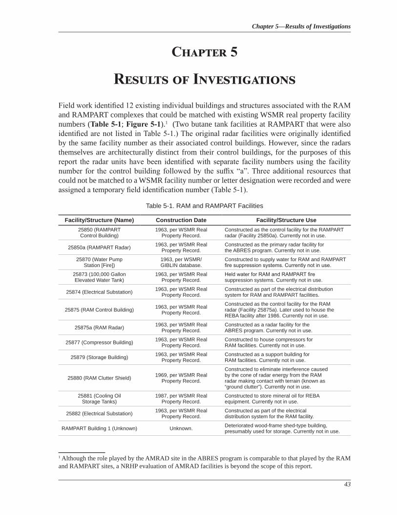
Chapter 5—Results of Investigations
43
Chapter 5
Results of InvestigationsField work identified 12 existing individual buildings and structures associated with the RAM and RAMPART complexes that could be matched with existing WSMR real property facility numbers (Table 5-1; Figure 5-1).1 (Two butane tank facilities at RAMPART that were also identified are not listed in Table 5-1.) The original radar facilities were originally identified by the same facility number as their associated control buildings. However, since the radars themselves are architecturally distinct from their control buildings, for the purposes of this report the radar units have been identified with separate facility numbers using the facility number for the control building followed by the suffix “a”. Three additional resources that could not be matched to a WSMR facility number or letter designation were recorded and were assigned a temporary field identification number (Table 5-1).
1 Although the role played by the AMRAD site in the ABRES program is comparable to that played by the RAM and RAMPART sites, a NRHP evaluation of AMRAD facilities is beyond the scope of this report.
Table 5-1. RAM and RAMPART Facilities
Facility/Structure (Name) Construction Date Facility/Structure Use25850 (RAMPART Control Building)
1963, per WSMR Real Property Record.
Constructed as the control facility for the RAMPART radar (Facility 25850a). Currently not in use.
25850a (RAMPART Radar) 1963, per WSMR Real Property Record.
Constructed as the primary radar facility for the ABRES program. Currently not in use.
25870 (Water Pump Station [Fire])
1963, per WSMR/GIBLIN database.
Constructed to supply water for RAM and RAMPART fire suppression systems. Currently not in use.
25873 (100,000 Gallon Elevated Water Tank)
1963, per WSMR Real Property Record.
Held water for RAM and RAMPART fire suppression systems. Currently not in use.
25874 (Electrical Substation) 1963, per WSMR Real Property Record.
Constructed as part of the electrical distribution system for RAM and RAMPART facilities.
25875 (RAM Control Building) 1963, per WSMR Real Property Record.
Constructed as the control facility for the RAM radar (Facility 25875a). Later used to house the REBA facility after 1986. Currently not in use.
25875a (RAM Radar) 1963, per WSMR Real Property Record.
Constructed as a radar facility for the ABRES program. Currently not in use.
25877 (Compressor Building) 1963, per WSMR Real Property Record.
Constructed to house compressors for RAM facilities. Currently not in use.
25879 (Storage Building) 1963, per WSMR Real Property Record.
Constructed as a support building for RAM facilities. Currently not in use.
25880 (RAM Clutter Shield) 1969, per WSMR Real Property Record.
Constructed to eliminate interference caused by the cone of radar energy from the RAM radar making contact with terrain (known as “ground clutter”). Currently not in use.
25881 (Cooling Oil Storage Tanks)
1987, per WSMR Real Property Record.
Constructed to store mineral oil for REBA equipment. Currently not in use.
25882 (Electrical Substation) 1963, per WSMR Real Property Record.
Constructed as part of the electrical distribution system for the RAM facility.
RAMPART Building 1 (Unknown) Unknown. Deteriorated wood-frame shed-type building, presumably used for storage. Currently not in use.
National Register Eligibility Evaluation of the RAM and RAMPART Sites White Sands Missile Range, Otero County, New Mexico
44
It should be noted that the identity of the two electrical facilities listed in Table 5-1 (Facilities 25874 and 25882) could not be positively established through research of DPW realty files as is customarily the case because the information in the files was incomplete and contradictory. For example, identifying photos in the files for both facilities were in reality two photos of the same facility.
5.1. RAMPART Control Building (Facility 25850, HCPI# 41207)
The RAMPART control building is a rectangular, utilitarian style building constructed of structural steel clad in metal siding built in 1963 by Herkenhoff & Associates, Inc. for the purposes of missile tracking (Figure 5-2). Since initial construction, the building underwent a renovation of office space and the installation of a “strong room” in 1970. The visible exterior construction consists of unpainted metal siding. The building is single story, and the foundation is poured concrete, at-grade and visible in some areas, while obfuscated in others. The building has one porch at the main entryway and several landings outside of various entryways. The building has a length that varies from 222 to 233 feet due to an extension on the southwest corner; the extension also gives the building a varying width from 34 to 75 feet.
The building is oriented along a northeast-southwest axis, with the main entrance in the center of the southeastern facing elevation. The main entrance is a single metal door. The southeastern facing elevation also includes two additional pairs of double metal doors and a pipe ladder that provides access to the roof. The northeastern facing elevation contains a single metal door at the northwest corner. The northwestern facing elevation includes two sets of double metal doors that share a single concrete landing. The landing is flanked by three louvered vents, two on the left side that are oriented vertically and one on the right side. The southwestern facing elevation includes a short hallway that connects the building to the RAMPART radar pedestal. This elevation also includes a single set of double metal doors. The building’s only fenestration, a fixed window with two lights, is located near this entryway. A chain-link fence topped with barbed wire begins approximately midway along the southeastern facing elevation and encircles the northeast end of the building, terminating approximately midway along the northwestern facing elevation. The fence has two gates, one near each end point. A second chain-link fence with barbed wire extends southeast from the southeast corner of the building, terminating approximately one-third of the way along the southeastern facing elevation, with one gate at the southeast corner of the building. A steel tower approximately 45 feet tall with square-spaced frame legs approximately three feet apart and a wooden pole approximately 30 feet tall are located near the midpoint of the northwest facing elevation adjacent to the building.
Facility/Structure (Name) Construction Date Facility/Structure Use
RAMPART Building 2 (Unknown) Unknown.Deteriorated rectangular, wood-frame building on raised wooden support foundation. Purpose unknown. Currently not in use.
RAMPART Building 3 (Unknown) Unknown, presumed 1963 or later.
Weathered, corrugated metal building situated atop metal beams. Used to store two electrical generators which are still in place. Currently not in use.
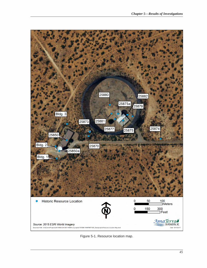
Chapter 5—Results of Investigations
45
Figure 5-1. Resource location map.
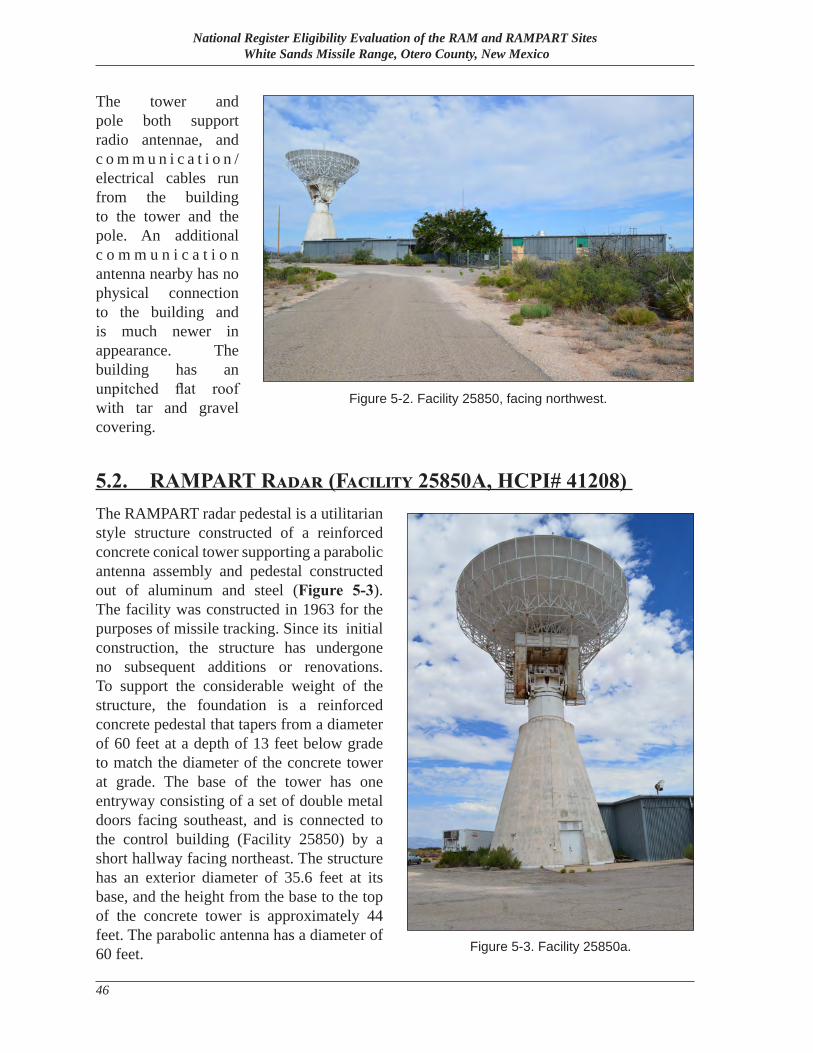
National Register Eligibility Evaluation of the RAM and RAMPART Sites White Sands Missile Range, Otero County, New Mexico
46
The tower and pole both support radio antennae, and c o m m u n i c a t i o n /electrical cables run from the building to the tower and the pole. An additional c o m m u n i c a t i o n antenna nearby has no physical connection to the building and is much newer in appearance. The building has an unpitched flat roof with tar and gravel covering.
5.2. RAMPART Radar (Facility 25850A, HCPI# 41208) The RAMPART radar pedestal is a utilitarian style structure constructed of a reinforced concrete conical tower supporting a parabolic antenna assembly and pedestal constructed out of aluminum and steel (Figure 5-3). The facility was constructed in 1963 for the purposes of missile tracking. Since its initial construction, the structure has undergone no subsequent additions or renovations. To support the considerable weight of the structure, the foundation is a reinforced concrete pedestal that tapers from a diameter of 60 feet at a depth of 13 feet below grade to match the diameter of the concrete tower at grade. The base of the tower has one entryway consisting of a set of double metal doors facing southeast, and is connected to the control building (Facility 25850) by a short hallway facing northeast. The structure has an exterior diameter of 35.6 feet at its base, and the height from the base to the top of the concrete tower is approximately 44 feet. The parabolic antenna has a diameter of 60 feet.
Figure 5-2. Facility 25850, facing northwest.
Figure 5-3. Facility 25850a.
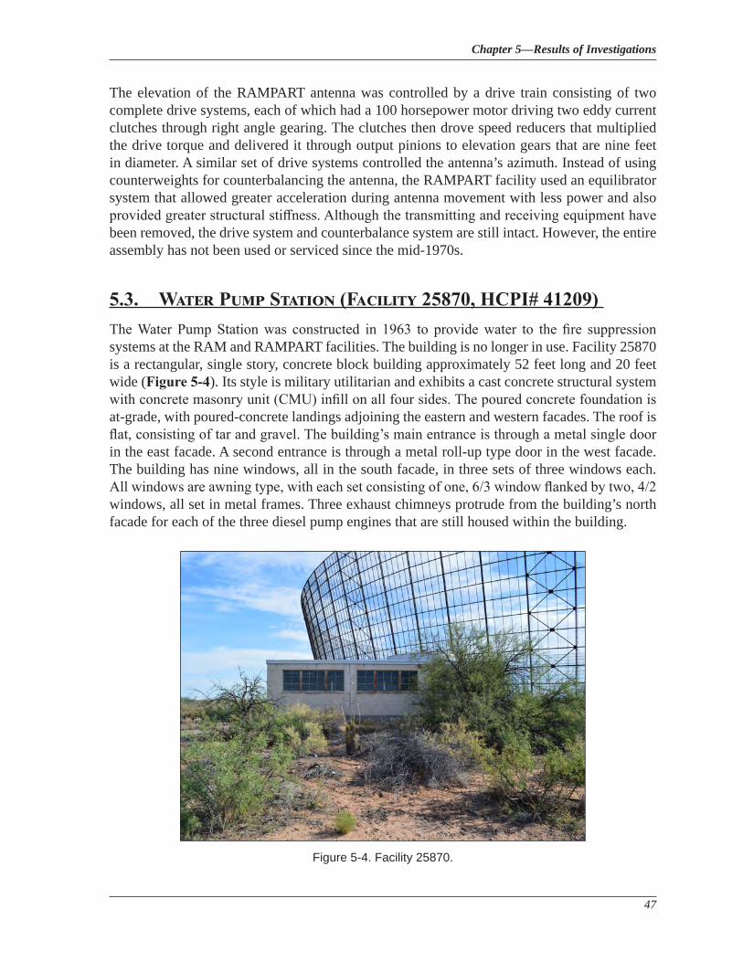
Chapter 5—Results of Investigations
47
The elevation of the RAMPART antenna was controlled by a drive train consisting of two complete drive systems, each of which had a 100 horsepower motor driving two eddy current clutches through right angle gearing. The clutches then drove speed reducers that multiplied the drive torque and delivered it through output pinions to elevation gears that are nine feet in diameter. A similar set of drive systems controlled the antenna’s azimuth. Instead of using counterweights for counterbalancing the antenna, the RAMPART facility used an equilibrator system that allowed greater acceleration during antenna movement with less power and also provided greater structural stiffness. Although the transmitting and receiving equipment have been removed, the drive system and counterbalance system are still intact. However, the entire assembly has not been used or serviced since the mid-1970s.
5.3. Water Pump Station (Facility 25870, HCPI# 41209) The Water Pump Station was constructed in 1963 to provide water to the fire suppression systems at the RAM and RAMPART facilities. The building is no longer in use. Facility 25870 is a rectangular, single story, concrete block building approximately 52 feet long and 20 feet wide (Figure 5-4). Its style is military utilitarian and exhibits a cast concrete structural system with concrete masonry unit (CMU) infill on all four sides. The poured concrete foundation is at-grade, with poured-concrete landings adjoining the eastern and western facades. The roof is flat, consisting of tar and gravel. The building’s main entrance is through a metal single door in the east facade. A second entrance is through a metal roll-up type door in the west facade. The building has nine windows, all in the south facade, in three sets of three windows each. All windows are awning type, with each set consisting of one, 6/3 window flanked by two, 4/2 windows, all set in metal frames. Three exhaust chimneys protrude from the building’s north facade for each of the three diesel pump engines that are still housed within the building.
Figure 5-4. Facility 25870.
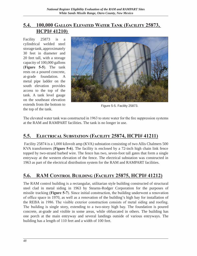
National Register Eligibility Evaluation of the RAM and RAMPART Sites White Sands Missile Range, Otero County, New Mexico
48
5.4. 100,000 Gallon Elevated Water Tank (Facility 25873, HCPI# 41210)
Facility 25873 is a cylindrical welded steel storage tank, approximately 30 feet in diameter and 20 feet tall, with a storage capacity of 100,000 gallons (Figure 5-5). The tank rests on a poured concrete, at-grade foundation. A metal pipe ladder on the south elevation provides access to the top of the tank. A tank level gauge on the southeast elevation extends from the bottom to the top of the tank.
The elevated water tank was constructed in 1963 to store water for the fire suppression systems at the RAM and RAMPART facilities. The tank is no longer in use.
5.5. Electrical Substation (Facility 25874, HCPI# 41211) Facility 25874 is a 1,000 kilovolt amp (KVA) substation consisting of two Allis Chalmers 500 KVA transformers (Figure 5-6). The facility is enclosed by a 72-inch high chain link fence topped by two-strand barbed wire. The fence has two, seven-foot tall gates that form a single entryway at the western elevation of the fence. The electrical substation was constructed in 1963 as part of the electrical distribution system for the RAM and RAMPART facilities.
5.6. RAM Control Building (Facility 25875, HCPI# 41212) The RAM control building is a rectangular, utilitarian style building constructed of structural steel clad in metal siding in 1963 by Stearns-Rodger Corporation for the purposes of missile tracking (Figure 5-7). Since initial construction, the building underwent a renovation of office space in 1970, as well as a renovation of the building’s high bay for installation of the REBA in 1986. The visible exterior construction consists of metal siding and roofing. The building is single story, extending to a two-story high bay. The foundation is poured concrete, at-grade and visible in some areas, while obfuscated in others. The building has one porch at the main entryway and several landings outside of various entryways. The building has a length of 110 feet and a width of 100 feet.
Figure 5-5. Facility 25873.
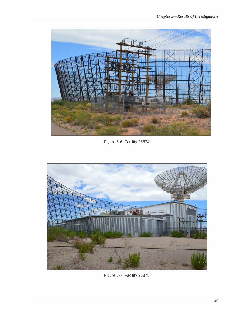
Chapter 5—Results of Investigations
49
Figure 5-7. Facility 25875.
Figure 5-6. Facility 25874.
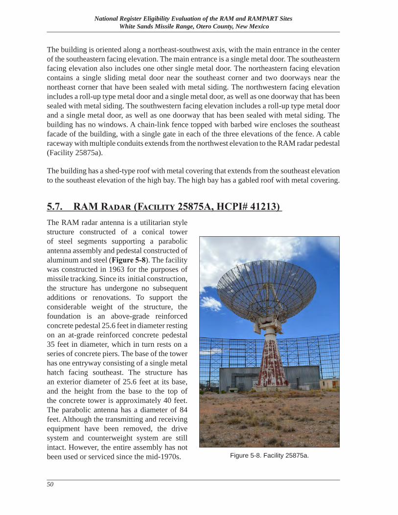
National Register Eligibility Evaluation of the RAM and RAMPART Sites White Sands Missile Range, Otero County, New Mexico
50
The building is oriented along a northeast-southwest axis, with the main entrance in the center of the southeastern facing elevation. The main entrance is a single metal door. The southeastern facing elevation also includes one other single metal door. The northeastern facing elevation contains a single sliding metal door near the southeast corner and two doorways near the northeast corner that have been sealed with metal siding. The northwestern facing elevation includes a roll-up type metal door and a single metal door, as well as one doorway that has been sealed with metal siding. The southwestern facing elevation includes a roll-up type metal door and a single metal door, as well as one doorway that has been sealed with metal siding. The building has no windows. A chain-link fence topped with barbed wire encloses the southeast facade of the building, with a single gate in each of the three elevations of the fence. A cable raceway with multiple conduits extends from the northwest elevation to the RAM radar pedestal (Facility 25875a).
The building has a shed-type roof with metal covering that extends from the southeast elevation to the southeast elevation of the high bay. The high bay has a gabled roof with metal covering.
5.7. RAM Radar (Facility 25875A, HCPI# 41213) The RAM radar antenna is a utilitarian style structure constructed of a conical tower of steel segments supporting a parabolic antenna assembly and pedestal constructed of aluminum and steel (Figure 5-8). The facility was constructed in 1963 for the purposes of missile tracking. Since its initial construction, the structure has undergone no subsequent additions or renovations. To support the considerable weight of the structure, the foundation is an above-grade reinforced concrete pedestal 25.6 feet in diameter resting on an at-grade reinforced concrete pedestal 35 feet in diameter, which in turn rests on a series of concrete piers. The base of the tower has one entryway consisting of a single metal hatch facing southeast. The structure has an exterior diameter of 25.6 feet at its base, and the height from the base to the top of the concrete tower is approximately 40 feet. The parabolic antenna has a diameter of 84 feet. Although the transmitting and receiving equipment have been removed, the drive system and counterweight system are still intact. However, the entire assembly has not been used or serviced since the mid-1970s. Figure 5-8. Facility 25875a.
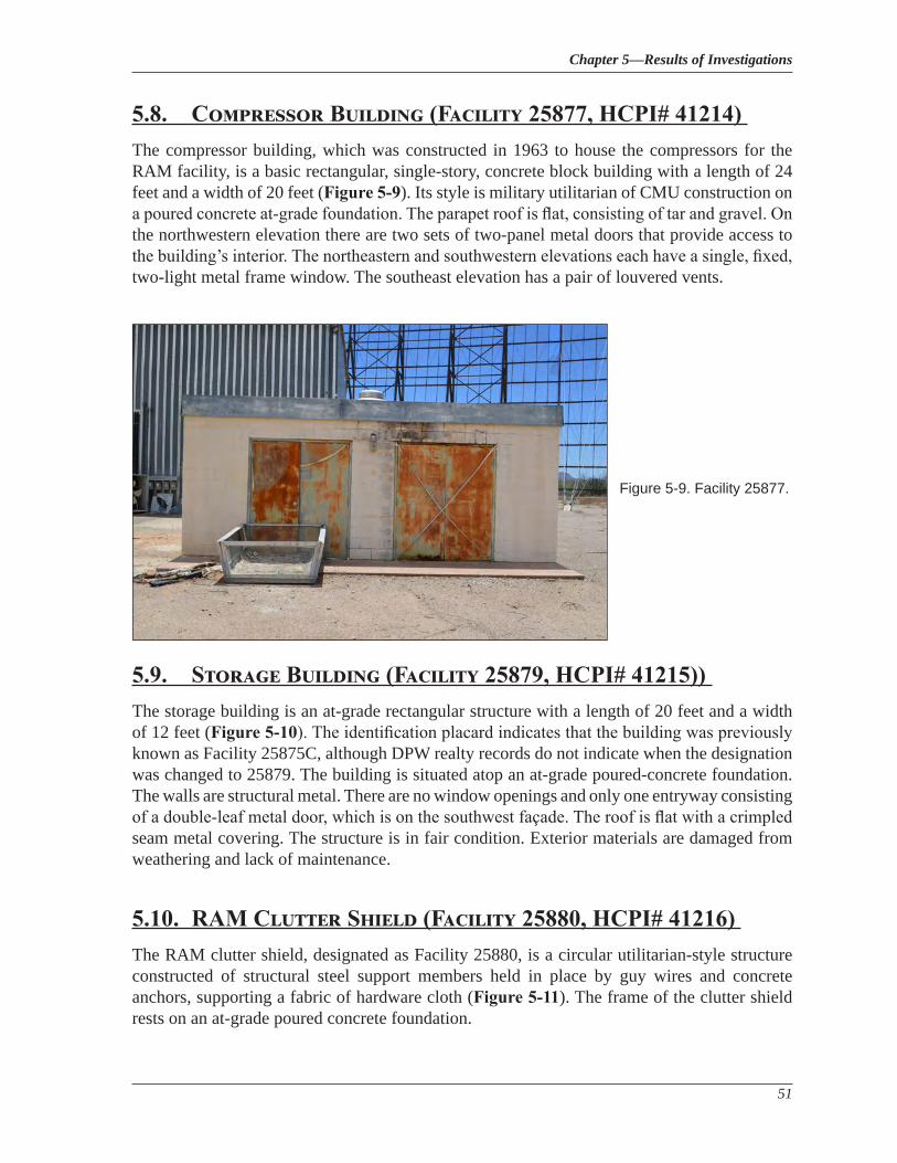
Chapter 5—Results of Investigations
51
5.8. Compressor Building (Facility 25877, HCPI# 41214) The compressor building, which was constructed in 1963 to house the compressors for the RAM facility, is a basic rectangular, single-story, concrete block building with a length of 24 feet and a width of 20 feet (Figure 5-9). Its style is military utilitarian of CMU construction on a poured concrete at-grade foundation. The parapet roof is flat, consisting of tar and gravel. On the northwestern elevation there are two sets of two-panel metal doors that provide access to the building’s interior. The northeastern and southwestern elevations each have a single, fixed, two-light metal frame window. The southeast elevation has a pair of louvered vents.
5.9. Storage Building (Facility 25879, HCPI# 41215)) The storage building is an at-grade rectangular structure with a length of 20 feet and a width of 12 feet (Figure 5-10). The identification placard indicates that the building was previously known as Facility 25875C, although DPW realty records do not indicate when the designation was changed to 25879. The building is situated atop an at-grade poured-concrete foundation. The walls are structural metal. There are no window openings and only one entryway consisting of a double-leaf metal door, which is on the southwest façade. The roof is flat with a crimpled seam metal covering. The structure is in fair condition. Exterior materials are damaged from weathering and lack of maintenance.
5.10. RAM Clutter Shield (Facility 25880, HCPI# 41216) The RAM clutter shield, designated as Facility 25880, is a circular utilitarian-style structure constructed of structural steel support members held in place by guy wires and concrete anchors, supporting a fabric of hardware cloth (Figure 5-11). The frame of the clutter shield rests on an at-grade poured concrete foundation.
Figure 5-9. Facility 25877.
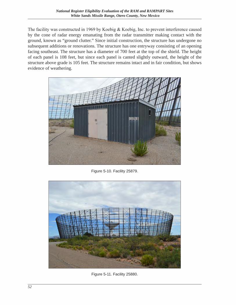
National Register Eligibility Evaluation of the RAM and RAMPART Sites White Sands Missile Range, Otero County, New Mexico
52
The facility was constructed in 1969 by Koebig & Koebig, Inc. to prevent interference caused by the cone of radar energy emanating from the radar transmitter making contact with the ground, known as “ground clutter.” Since initial construction, the structure has undergone no subsequent additions or renovations. The structure has one entryway consisting of an opening facing southeast. The structure has a diameter of 700 feet at the top of the shield. The height of each panel is 108 feet, but since each panel is canted slightly outward, the height of the structure above grade is 105 feet. The structure remains intact and in fair condition, but shows evidence of weathering.
Figure 5-11. Facility 25880.
Figure 5-10. Facility 25879.
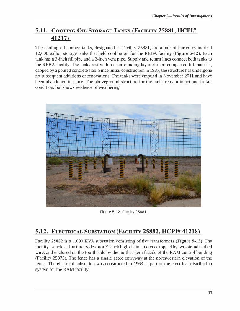
Chapter 5—Results of Investigations
53
5.11. Cooling Oil Storage Tanks (Facility 25881, HCPI# 41217)
The cooling oil storage tanks, designated as Facility 25881, are a pair of buried cylindrical 12,000 gallon storage tanks that held cooling oil for the REBA facility (Figure 5-12). Each tank has a 3-inch fill pipe and a 2-inch vent pipe. Supply and return lines connect both tanks to the REBA facility. The tanks rest within a surrounding layer of inert compacted fill material, capped by a poured concrete slab. Since initial construction in 1987, the structure has undergone no subsequent additions or renovations. The tanks were emptied in November 2011 and have been abandoned in place. The aboveground structure for the tanks remain intact and in fair condition, but shows evidence of weathering.
5.12. Electrical Substation (Facility 25882, HCPI# 41218) Facility 25882 is a 1,000 KVA substation consisting of five transformers (Figure 5-13). The facility is enclosed on three sides by a 72-inch high chain link fence topped by two-strand barbed wire, and enclosed on the fourth side by the northeastern facade of the RAM control building (Facility 25875). The fence has a single gated entryway at the northwestern elevation of the fence. The electrical substation was constructed in 1963 as part of the electrical distribution system for the RAM facility.
Figure 5-12. Facility 25881.
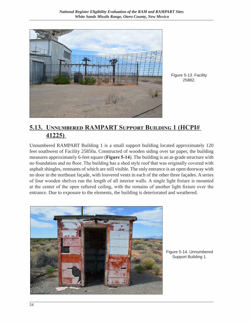
National Register Eligibility Evaluation of the RAM and RAMPART Sites White Sands Missile Range, Otero County, New Mexico
54
5.13. Unnumbered RAMPART Support Building 1 (HCPI# 41225)
Unnumbered RAMPART Building 1 is a small support building located approximately 120 feet southwest of Facility 25850a. Constructed of wooden siding over tar paper, the building measures approximately 6-feet square (Figure 5-14). The building is an at-grade structure with no foundation and no floor. The building has a shed style roof that was originally covered with asphalt shingles, remnants of which are still visible. The only entrance is an open doorway with no door in the northeast façade, with louvered vents in each of the other three façades. A series of four wooden shelves run the length of all interior walls. A single light fixture is mounted at the center of the open raftered ceiling, with the remains of another light fixture over the entrance. Due to exposure to the elements, the building is deteriorated and weathered.
Figure 5-13. Facility 25882.
Figure 5-14. Unnumbered Support Building 1.
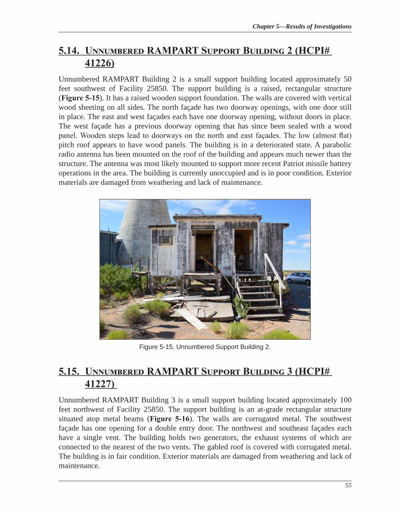
Chapter 5—Results of Investigations
55
5.14. Unnumbered RAMPART Support Building 2 (HCPI# 41226)
Unnumbered RAMPART Building 2 is a small support building located approximately 50 feet southwest of Facility 25850. The support building is a raised, rectangular structure (Figure 5-15). It has a raised wooden support foundation. The walls are covered with vertical wood sheeting on all sides. The north façade has two doorway openings, with one door still in place. The east and west façades each have one doorway opening, without doors in place. The west façade has a previous doorway opening that has since been sealed with a wood panel. Wooden steps lead to doorways on the north and east façades. The low (almost flat) pitch roof appears to have wood panels. The building is in a deteriorated state. A parabolic radio antenna has been mounted on the roof of the building and appears much newer than the structure. The antenna was most likely mounted to support more recent Patriot missile battery operations in the area. The building is currently unoccupied and is in poor condition. Exterior materials are damaged from weathering and lack of maintenance.
5.15. Unnumbered RAMPART Support Building 3 (HCPI# 41227)
Unnumbered RAMPART Building 3 is a small support building located approximately 100 feet northwest of Facility 25850. The support building is an at-grade rectangular structure situated atop metal beams (Figure 5-16). The walls are corrugated metal. The southwest façade has one opening for a double entry door. The northwest and southeast façades each have a single vent. The building holds two generators, the exhaust systems of which are connected to the nearest of the two vents. The gabled roof is covered with corrugated metal. The building is in fair condition. Exterior materials are damaged from weathering and lack of maintenance.
Figure 5-15. Unnumbered Support Building 2.
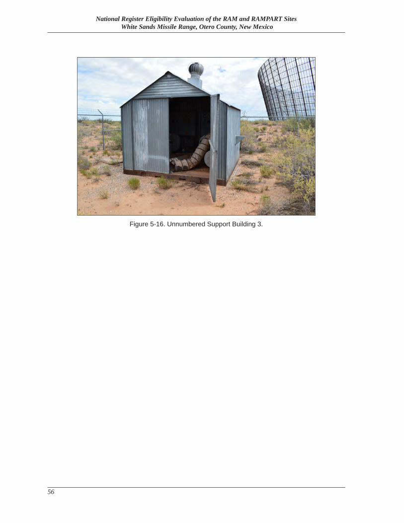
National Register Eligibility Evaluation of the RAM and RAMPART Sites White Sands Missile Range, Otero County, New Mexico
56
Figure 5-16. Unnumbered Support Building 3.
Chapter 6—Eligibility Assessments and Management Recommendations
57
Chapter 6
Eligibility Assessments and Management Recommendations
In July 2016, AmaTerra cultural resource specialists evaluated resources for individual eligibility and as contributing or non-contributing elements of a military landscape historic district.
6.1. Previous Eligibility RecommendationsIn 1996, HSR conducted a survey of the buildings and structures composing the RAM and RAMPART sites. The survey covered Facilities 25850, 25850a, 25870, 25875, 25875a, 25877, 25879, and 25880. Although the survey included a brief discussion of historic context for many of the facilities, a detailed historic context was not included in the survey, and no discussion of eligibility was made although the survey did list several of the resources are “potentially eligible” (Human Systems Research 1996a, 1996b).
6.2. National Register Eligibility RecommendationsIn 2016, cultural resource staff from AmaTerra conducted a historic resource survey of the RAM and RAMPART sites in order to collect sufficient data to make supported recommendations of the resources for eligibility for listing in the NRHP. The findings and recommendations for RAM and RAMPART are discussed as follows.
6.2.1 The Significance of the RAM/RAMPART Historic District
The RAM and RAMPART facilities are recommended as eligible for listing in the NRHP as a single historic district, with 13 existing facilities contributing to the district (including two butane tanks that are not listed in Table 5.1) and four facilities recommended as non-contributing due to their being constructed outside of the period of significance and/or not being definitively associated with the primary mission of RAM and RAMPART. The recommended RAM/RAMPART Historic District is historically significant at the national level under Criterion A for its association with events that have contributed to the broad patterns of American History. The recommended contributing district resources, set within the context of the Cold War within the areas of significance of Communications and Military, exhibit a period of significance of 1963-1973, covering the beginning of construction of the two ABRES-related sites to the end of the end of the ABRES program, which was closely followed by the deactivation of both sites.
The recommended RAM/RAMPART Historic District is a historic component of its parent landscape, WSMR, commissioned in 1945 and recognized as the nation’s foremost missile and weapons testing location during the Cold War. The RAM and RAMPART sites were established in 1963, when both WSMR and the Cold War were well established. WSMR’s
National Register Eligibility Evaluation of the RAM and RAMPART Sites White Sands Missile Range, Otero County, New Mexico
58
location, physical security, existing instrumentation, and established role in missile testing led to its selection as a testing site for the ABRES program, which in turn led to the construction of the RAM and RAMPART sites in their current locations.
Criteria Consideration G indicates that a property that achieves significance within the past fifty years or whose period of significance extends beyond the standard 50-year cut-off date is eligible for NRHP listing if it is of exceptional importance. National Register Bulletin 22: Guidelines for Evaluating and Nominating Properties that Have Achieved Significance Within the Past Fifty Years explains that the NRHP “does not include properties important solely for their contemporary impact and visibility”, and that Consideration G “safeguards against listing properties which are of only contemporary, faddish value and ensures that the National Register is a register of historic places [emphasis in original] (1).”
The significance of the research activities conducted at the RAM and RAMPART sites during the ABRES program clearly meets the standard established by Criteria Consideration G. ICBM re-entry vehicles, along with the countermeasures that were developed to insure their survivability in a hostile environment, have been an integral component of the ICBMs that comprised the U.S. nuclear arsenal from 1970 through the present day. It is not an overstatement to say that the survival of the United States as a nation during the closing decades of the Cold War was directly dependent upon the work done at the RAM and RAMPART sites during the ABRES program.
In contrast, the subsequent work in nuclear survivability of equipment conducted at the RAM site (REBA) requires what National Register Bulletin 22 describes as “the passage of time” which “allows our perceptions to be influenced by education, the judgment of previous decades, and the dispassion of distance” in order to evaluate its historic significance (1). The work conducted at REBA from 1987 through the late 2000s was clearly important. However, its importance is not clearly “exceptional”, and therefore does not meet the standard of Criteria Consideration G.
6.2.2 The Integrity of the RAM/RAMPART Historic District
The integrity of the recommended RAM/RAMPART Historic District is evidenced by the survival of physical characteristics that existed during the district’s historic period of significance. The ability of the RAM and RAMPART sites to convey their significance is greatly enhanced by their generally unbroken historic integrity, reflected in their intact Location, Setting, Design, Materials, Workmanship, and Association.
LocationIntegrity of location of the vast majority of contributing elements of the recommended RAM/RAMPART Historic District is intact. All of the primary buildings remain in their original locations at the site and help preserve the original character and layout of both sites. All contributing elements were constructed during the period of significance. While much of the
Chapter 6—Eligibility Assessments and Management Recommendations
59
radar and related communications equipment has been removed, The RAM and RAMPART sites retain sufficient integrity of location to convey their significance.
DesignAlthough some of the buildings at RAM and RAMPART have undergone modifications since construction, many of the modifications happened within the period of significance. Modifications after the period of significance related to REBA were primarily internal modifications that did not significantly alter the structural design features of their respective facility. Other modifications such as filled-in doorways are minor alterations to the overall design of both sites. Building arrangement and circulation patterns between them remain intact from the historic period.
SettingIntegrity of setting of the RAM and RAMPART sites is generally intact. The historic orientation of buildings and structures at both sites has remained unchanged during and since the period of significance. The surrounding desert landscape has similarly remained largely undeveloped, with few intrusions into the visual background. Notably, the uninterrupted view of the ABRES impact zones to the northwest remains intact, a character-defining feature of both sites. RAM and RAMPART retain sufficient integrity of setting to convey their significance.
MaterialsAs with design, the materials of the RAM and RAMPART sites are mostly intact from the historic period. All of the buildings exhibit original construction materials, with minor additions and modifications. The buildings lack most of the technical equipment required for tracking missiles and re-entry vehicles in flight, most notably the transmitter equipment for both radars. The loss of the technical equipment is a factor in individual eligibility of the various buildings at RAM and RAMPART, but does not sufficiently impact the integrity of the recommended district as a whole to a degree that it can no longer convey significance. As such, the RAM and RAMPART sites retain sufficient integrity of materials.
WorkmanshipClosely tied to materials, integrity of workmanship of the RAM and RAMPART sites is generally intact. The buildings display original construction techniques as well as materials, with most modifications happening during the period of significance. With individual buildings, the loss of technical equipment does impact individual integrity of workmanship, given the importance of the technological capabilities once exhibited at both sites. However, the loss of the technical equipment does not impact integrity of workmanship to a degree that it can no longer convey significance. Thus, the sites at RAM and RAMPART retain sufficient integrity of workmanship.
National Register Eligibility Evaluation of the RAM and RAMPART Sites White Sands Missile Range, Otero County, New Mexico
60
FeelingAt its peak RAM and RAMPART witnessed a tremendous amount of activity tracking missiles and test vehicles, with up to three ABRES-related launches a day taking place. With the conclusion of the ABRES program, however, the amount of activity decreased significantly, with facilities either going into “caretaker” status or being deactivated by 1973. While the RAM site saw activity again beginning in the 1980s, the degree and nature of activity had substantially shifted. The buildings are vacant and have not been used in many years. A visitor from the period of significance would recognize the RAM and RAMPART sites today for what they are, but the recommended district would not have the same sense of feeling due to the loss of activity and focus on the radar facilities. As such, RAM and RAMPART sites do not retain integrity of feeling.
AssociationContrary to feeling, RAM and RAMPART sites still retain much of their association with their past mission due to the presence of all of their important buildings, location and layout. The orientation of the buildings to the northwest and the presence of the massive radar antennae and clutter shield attests to the strong association between both sites and their past functions. RAM and RAMPART sites retain sufficient integrity of association to convey their significance.
6.2.3 RAM/RAMPART as a Historic Military Landscape
While the RAM/RAMPART sites are significant under Criterion A and possess sufficient integrity to convey this significance as a historic district, they are also considered a military landscape. A military landscape is one that has been directly shaped by human activity in support of military missions. A historic military landscape requires association with significant historic events or persons, or contains significant examples of design or construction. It must also possess sufficient integrity to convey its significance through this association and/or the features themselves (Loechl, et. al. 1994: 9). In addition, a military landscape is measured through nine specific characteristics (as noted previously in Section 4.4): Spatial Organization and Land Use; Response to Natural Environment; Expression of Military Cultural Values; Circulation Networks; Boundary Demarcations; Vegetation,; Buildings, Structures, and Objects; Clusters of Buildings, Structures, and Objects; and Archeological Sites (Loechl, et. al. 1994: 36-40).
As the RAM/RAMPART sites have been evaluated as a historic district above, the following is an abbreviated analysis of the historic district as a historic military landscape.
Spatial Organization and Land UseThe spatial organization at RAM/RAMPART was dependent on providing the longest and most unobstructed view to incoming Athena missiles launched as part of the ABRES program. As such, the facilities were constructed at the southeast end of the Athena impact zones (as seen in Figure 3-7), near the southeast corner of the range. The facilities are located at the end of their own service road [Range Road (RR) 259], approximately eight miles north of the Orogrande
Chapter 6—Eligibility Assessments and Management Recommendations
61
Range Camp. The relative remoteness of the location provided additional protection against stray electrical interference. The facilities are grouped generally by radar facility (RAMPART outside of the clutter fence, and RAM inside and adjacent to it), although some buildings such as the electrical substation (Facility 25874) served both. Most features at RAM/RAMART are located behind the two radars in relation to the direction of incoming test vehicles.
Response to the Natural EnvironmentRAM/RAMPART are located in a relatively flat and remote part of WSMR, although the Jarilla Mountains form a nearby backdrop. However, the natural environment was likely not a major criterion in site selection for RAM/RAMPART beyond the level ground. WSMR as a whole benefits from the natural environment of the Tularosa Basin as discussed in the historic context; the benefits of WSMR’s location thus are naturally shared by RAM/RAMPART.
Expression of Military Cultural ValuesAs with many important technical facilities at WSMR, the values expressed by RAM/RAMPART are driven more by the requirements of the research, development, testing, and evaluation process than by military aesthetics, patriotism, or displays of hierarchy. Such military values, as described by hierarchy, uniformity, discipline, utility, and patriotism, are generally more on display in administrative and residential areas of a military landscape. Nonetheless, the location of RAM/RAMPART in a remote section of the range and its utilitarian nature reflect both the general hierarchy present at WSMR and the order established on the range as a whole to best utilize WSMR’s vast array of instrumentation.
Circulation NetworksCirculation networks at RAM/RAMPART are generally limited to RR 259, which confines vehicular traffic to locations generally out of the way of the two radars. Beyond RR 259, RAM/RAMPART are connected to WSMR through RR 252 and RR 2, which leads to the main cantonment to the west.
Boundary DemarcationsRAM/RAMPART have no formal boundaries beyond the confines of the scatter fence. They are informally marked by RR 259 to the south and some temporary dirt access tracks leading away from the facilities to the northwest and northeast.
VegetationThe vegetation at RAM/RAMPART is strictly wild, naturally occurring desert scrub and is not landscaped in any coordinated manner. Plants nearby include creosote bush, tarbush, and honey mesquite. What landscaping has been performed in the past has been limited to clearing the natural vegetation for construction, and for keeping the operational areas tidy and vegetation-free, although this maintenance has generally been limited since the facilities were vacated.
National Register Eligibility Evaluation of the RAM and RAMPART Sites White Sands Missile Range, Otero County, New Mexico
62
Buildings, Structures, and ObjectsThe majority of buildings, structures, and objects recorded at RAM/RAMPART is directly related to the military missions of which the resources were a part, primarily the ABRES program. Generally evenly divided between buildings and structures, these resources are the main components of RAM/RAMPART and play a primary role in defining the historic military landscape. The survey inventoried 17 individual resources (two tanks are grouped as one in the survey inventory), 12 of which are recommended as contributing to the historic district.
Clusters of Buildings, Structures, and ObjectsThe cluster arrangement at RAM/RAMPART is essentially divided into two groups of buildings: the RAMPART resources, and the RAM resources. The RAMPART resources are mainly limited to the control building (Facility 25850) and the radar itself (25850a), although other non-contributing buildings (such as Buildings 1–3) are lumped in with it due to proximity. The RAM resources are mostly contained with the clutter shield (Facility 25880), which serves as a logical boundary for the cluster. Scattered around these two primary clusters are three support buildings which served both systems (Facilities 25870, 25873, and 25874).
Archeological SitesAlthough WSMR has an immense number of archeological sites within its boundaries, only one is located near RAM/RAMPART. LA112446 consists of an adobe wall five meters long and 10 centimeters wide exposed by a road cut. The wall has no associations with the site, and it is unlikely to have any military associations at all. Prior to the establishment of WSPG, the Tularosa Basin was host to a large number of ranches and homesteads. Given the location and composition of the site, it is likely a remnant of a ranch or homestead, and thus predates the military use of the landscape. Thus, no historic archeological sites are considered to be part of the historic military landscape at RAM/RAMPART.
6.2.4 Individual Eligibility of RAM and RAMPART Facilities
The RAM radar (Facility 25875a) and RAMPART radar (Facility 25850a) each retain significant integrity of location, design, setting, and association to individually convey their historic significance under Criterion A. As they were originally built, each of these structures would also display distinctive characteristics of a type, period, and method of construction (namely the development of analog radar for the tracking of re-entry vehicles during the Cold War) to make them individually eligible for NRHP listing under Criterion C. However, with the removal of the transmitter equipment from each of the radars, they do not retain significant integrity of workmanship and materials to qualify for individual eligibility under Criterion C.
The RAM clutter shield (Facility 25880) individually retains integrity of location, setting, design, workmanship, materials, and association. It illustrates distinctive characteristics of another type and method of construction during the Cold War period. The use of clutter shields or clutter fences was a design solution that was unique to ground-based analog radar facilities that were used to track airborne targets. With the development of digital radar, clutter shields
Chapter 6—Eligibility Assessments and Management Recommendations
63
no longer became necessary, since ground clutter could be digitally eliminated from radar displays. Since the height of clutter shields was normally determined both by surrounding terrain and the height of the radar antenna, most examples of radar clutter shields, such as those used by Nike Zeus radar facilities at WSMR and Kwajalein, were only 30-40 feet tall at most. At 105 feet, the RAM clutter shield may well have been the tallest such facility ever built. Because of its considerable degree of integrity, its historic role, and the nature of its construction, the RAM clutter shield individually qualifies for NRHP listing under Criteria A and C.
6.2.5 National Register Boundary Recommendations
The RAM and RAMPART sites did not have official boundaries during their period of significance. However, the clutter shields for RAM does serve as a physical boundary for the site. The proposed boundary for the historic district encompass the surviving built environment for both sites from the period of significance. The list of contributing buildings may be found in Table 6.1 below. The proposed boundaries are shown in Figure 6-1, with UTM coordinates listed in Table 6.2.
6.2.6 Summary
Set within the context of the Cold War, the RAM and RAMPART tracking radar facilities at WSMR were invaluable in the development of re-entry vehicles and countermeasures that vastly improved the yield and capabilities of the ICBMs that made up the U.S. nuclear deterrent force. As part of the ABRES and program from 1962 to 1973, these radar facilities examined how to develop and improve the survivability of ICBM-launched nuclear warheads. Although no longer used for their historic role, the buildings and structures at both of these sites serve as a reminder of the important role they played in WSMR’s storied history. The RAM/RAMPART Historic District is recommended as eligible under Criterion A at the national level in the areas of Communications and Military, with a period of significance of 1963-1973. The individual RAM and RAMPART radars are recommended eligible under Criterion A, and the RAM clutter shield are recommended as individually eligible under Criteria A and C.
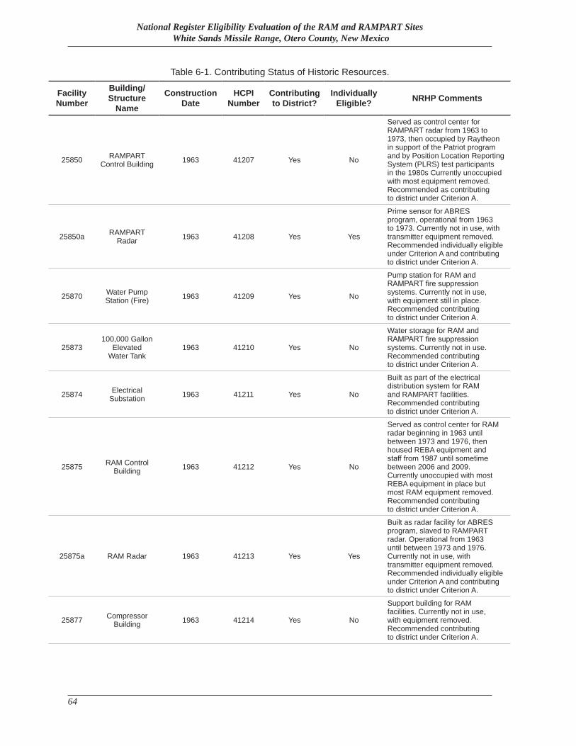
National Register Eligibility Evaluation of the RAM and RAMPART Sites White Sands Missile Range, Otero County, New Mexico
64
Table 6-1. Contributing Status of Historic Resources.
Facility Number
Building/Structure
Name
Construction Date
HCPI Number
Contributing to District?
Individually Eligible? NRHP Comments
25850 RAMPART Control Building 1963 41207 Yes No
Served as control center for RAMPART radar from 1963 to 1973, then occupied by Raytheon in support of the Patriot program and by Position Location Reporting System (PLRS) test participants in the 1980s Currently unoccupied with most equipment removed. Recommended as contributing to district under Criterion A.
25850a RAMPART Radar 1963 41208 Yes Yes
Prime sensor for ABRES program, operational from 1963 to 1973. Currently not in use, with transmitter equipment removed. Recommended individually eligible under Criterion A and contributing to district under Criterion A.
25870 Water Pump Station (Fire) 1963 41209 Yes No
Pump station for RAM and RAMPART fire suppression systems. Currently not in use, with equipment still in place. Recommended contributing to district under Criterion A.
25873100,000 Gallon
Elevated Water Tank
1963 41210 Yes No
Water storage for RAM and RAMPART fire suppression systems. Currently not in use. Recommended contributing to district under Criterion A.
25874 Electrical Substation 1963 41211 Yes No
Built as part of the electrical distribution system for RAM and RAMPART facilities. Recommended contributing to district under Criterion A.
25875 RAM Control Building 1963 41212 Yes No
Served as control center for RAM radar beginning in 1963 until between 1973 and 1976, then housed REBA equipment and staff from 1987 until sometime between 2006 and 2009. Currently unoccupied with most REBA equipment in place but most RAM equipment removed. Recommended contributing to district under Criterion A.
25875a RAM Radar 1963 41213 Yes Yes
Built as radar facility for ABRES program, slaved to RAMPART radar. Operational from 1963 until between 1973 and 1976. Currently not in use, with transmitter equipment removed. Recommended individually eligible under Criterion A and contributing to district under Criterion A.
25877 Compressor Building 1963 41214 Yes No
Support building for RAM facilities. Currently not in use, with equipment removed. Recommended contributing to district under Criterion A.
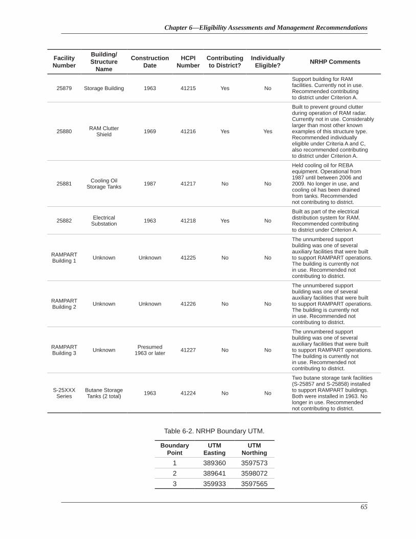
Chapter 6—Eligibility Assessments and Management Recommendations
65
Facility Number
Building/Structure
Name
Construction Date
HCPI Number
Contributing to District?
Individually Eligible? NRHP Comments
25879 Storage Building 1963 41215 Yes NoSupport building for RAM facilities. Currently not in use. Recommended contributing to district under Criterion A.
25880 RAM Clutter Shield 1969 41216 Yes Yes
Built to prevent ground clutter during operation of RAM radar. Currently not in use. Considerably larger than most other known examples of this structure type. Recommended individually eligible under Criteria A and C, also recommended contributing to district under Criterion A.
25881 Cooling Oil Storage Tanks 1987 41217 No No
Held cooling oil for REBA equipment. Operational from 1987 until between 2006 and 2009. No longer in use, and cooling oil has been drained from tanks. Recommended not contributing to district.
25882 Electrical Substation 1963 41218 Yes No
Built as part of the electrical distribution system for RAM. Recommended contributing to district under Criterion A.
RAMPART Building 1 Unknown Unknown 41225 No No
The unnumbered support building was one of several auxiliary facilities that were built to support RAMPART operations. The building is currently not in use. Recommended not contributing to district.
RAMPART Building 2 Unknown Unknown 41226 No No
The unnumbered support building was one of several auxiliary facilities that were built to support RAMPART operations. The building is currently not in use. Recommended not contributing to district.
RAMPART Building 3 Unknown Presumed
1963 or later 41227 No No
The unnumbered support building was one of several auxiliary facilities that were built to support RAMPART operations. The building is currently not in use. Recommended not contributing to district.
S-25XXX Series
Butane Storage Tanks (2 total) 1963 41224 No No
Two butane storage tank facilities (S-25857 and S-25858) installed to support RAMPART buildings. Both were installed in 1963. No longer in use. Recommended not contributing to district.
Table 6-2. NRHP Boundary UTM.
Boundary Point
UTM Easting
UTM Northing
1 389360 35975732 389641 35980723 359933 3597565
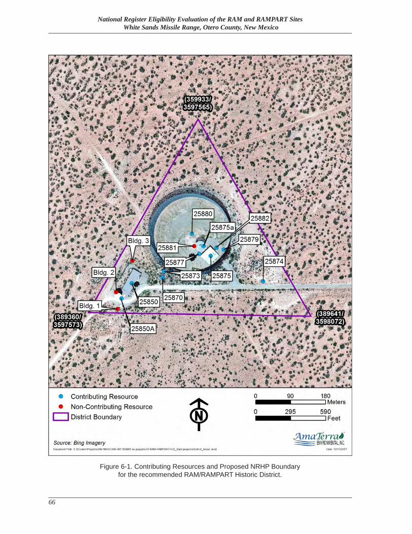
National Register Eligibility Evaluation of the RAM and RAMPART Sites White Sands Missile Range, Otero County, New Mexico
66
Figure 6-1. Contributing Resources and Proposed NRHP Boundary for the recommended RAM/RAMPART Historic District.
References
67
References
Aerospace Corporation1963 Range Data Book – White Sands Missile Range: Volume II – Instrumentation. Report No. ATN-
63(3153-07)-1 Vol II. San Bernardino, California.
Atlantic Research Corporation1969 “White Sands Missile Range: Major Fixed Instrumentation for Support of the ABRES ‘Athena’
Program.” Chart prepared by Atlantic Research Corporation Missile Systems Division, 24 June.
1971 “Athena Flight Test Matrix.” Chart prepared by Atlantic Research Corporation Missile Systems Division, ca. 16 April.
Ballard, Jr., Robert F.1969 Effect of Antenna Operation on Structure and Foundation Behavior, AMRAD and RAMPART
Radar Towers, White Sands Missile Range, New Mexico. U.S. Army Engineer Waterways Experiment Station, Vicksburg, Mississippi.
Building Technology, Inc.1984 Historic Properties Report: White Sands Missile Range, New Mexico, and Sub-installation
Utah Launch Complex, Green River, Utah.
Bureau of Land Management2013 “Homesteading in New Mexico”. http://www.blm.gov/nm/st/en/prog/more/cultural_resources/homesteads_in_new.html (accessed September 1, 2016).
Business Week1963 “Get Ready to Duck.” Business Week. 25 May.
Bustamante, Carlos2016 Telephone interview with author. 16 February.
Caldwell, Hartley1966 “The Missilemen at Green River.” The Airman. September 1966, 20–23.
Crone, J. L.1961 “Ballistic Missile Systems.” Ballistic Missile Defense Papers Presented at 5th Mil-E-Con
National Convention, Washington, D.C., 28 June 1961. Advanced Research Projects Agency Ballistic Missile Defense Office, Washington DC.
National Register Eligibility Evaluation of the RAM and RAMPART Sites White Sands Missile Range, Otero County, New Mexico
68
Eckles, Jim2013 A Pocketful of Rockets: History and Stories Behind White Sands Missile Range. Fiddlebike
Partnershp, Las Cruces, New Mexico.
Eidenbach, Peter, et al.1996 Star Throwers of the Tularosa: The Early Cold War Legacy of White Sands Missile Range.
Human Systems Research, Inc., Inc.
Feit, Rachel, et al.2014 Cultural Resource Assessment of the Green River Test Site, Utah. Prepared by AmaTerra
Environmental, Inc. for Environmental Stewardship Branch, White Sands Missile Range. AmaTerra Technical Report No. 71.
Flanders, Mike2016 Interview with author. 5 February. White Sands Missile Range, New Mexico.
Gansler, Jacques S.2010 Ballistic Missile Defense Past and Future. Center for Technology and National Security Policy,
National Defense University, Washington, DC.
Globalsecurity.org2016 “LGM-30 Minuteman III ICBM – United States Nuclear Forces.” http://www.globalsecurity.
org/wmd/systems/lgm-30_3.htm (accessed 24 June 2016).
Great Falls Tribune2014 “Last Malmstrom ICBM Reconfigured Under Treaty.” 18 June. Great Falls, Montana.
Greenwood, John T.1979 Space and Missile Systems Organization: A Chronology, 1954–1979. Air Force Chief of Staff
History Office, Washington DC.
Human Systems Research1996a WSMR Facility: Ram Site. HSR Project No. 9422.1996b WSMR Facility: Rampart Site. HSR Project No. 9422.
Ingwersen, Philip A. and William Z. Lemnios2000 “Radars for Ballistic Missile Defense Research.” Lincoln Laboratory Journal. Vol. 12, No. 2,
2000. 245–266.
References
69
Jenks, Jim, et al.2015 National Register Eligibility Recommendations of the Mule Peak Site, Lincoln National Forest
in Otero County, New Mexico. Prepared by AmaTerra Environmental, Inc. for North Wind Services and Directorate of Public Works, White Sands Missile Range. AmaTerra Technical Report No. 104.
Korfmacher, K.2015 History of Cinetheodolite and Other Optical Tracking Technology at White Sands Missile
Range, New Mexico, 1945–1965. Prepared by AmaTerra Environmental, Inc. for Directorate of Public Works, White Sands Missile Range. AmaTerra Technical Report No. 70.
Loechl, S. K., S. A. Batzli, and S. I. Encore1994 Guidelines for Documenting and Evaluating Historic Military Landscapes: An Integrated
Landscape Approach. AEC Technical Guideline Prepared by U.S. Army Construction Engineering Research Laboratory. Champaign, Illinois.
Manevitch, B. A.1964 Low Observable Re-entry Vehicle Program Subscale Vehicle Flight Test Data and Support
Requirements, White Sands Missile Range. Report No. RAD-SR-63-40 Rev. II. US Air force Ballistic Systems Division, Norton Air force Base, California.
Marsh, H. G.1965 System Description and Test Results: RAMPART Radar AN/FPS-62(XW-1). Technical Report
No. RADC-TR-65-80. Rome Air Development Center, Briffiss Air Force Base, NY.
O’Neill, John W.1969 “Space and Missile Systems Organization: Working Partner with Industry”. Defense Industry
Bulletin. October 1969, 1–5, 28.
Raytheon Company 1961 ARPAT Project Technical Summary Report No. 1 for ARPAT Measurements Radar, July–
September 1961. Report No. BR-1360. Raytheon Company Missile and Space Division, Bedford, Massachusetts.
Salmon, J. S. 2011 Protecting America: Cold War Defensive Sites. A National Historic Landmark Theme Study.
National Park Service, U.S. Department of Interior.
Salt Lake Tribune1971 “Fiery Athena Soars on 5-Minute, Traffic-Stopping Ride”. 14 August. Salt Lake City, Utah.
National Register Eligibility Evaluation of the RAM and RAMPART Sites White Sands Missile Range, Otero County, New Mexico
70
United States Air Force2015 “LGM-30G Minuteman III”. http://www.af.mil/AboutUs/FactSheets/Display/tabid/224/
Article/104466/lgm-30g-minuteman-iii.aspx (accessed 24 June 2016).
United States Department of Defense1960 White Sands History: Range Beginnings and Early Missile Testing. Public Affairs Office, White
Sands Missile Range, New Mexico, c. 1960.1969 “Ballisticians in War and Peace,” A History of the United States Army Ballistic Research
Laboratories, 1914–1956. Volume I. Aberdeen Proving Ground, MD.1975 History of Strategic Air and Ballistic Missile Defense, Volume 1, 1945–1955, and Volume
2, 1956–1972. U.S. Army Center for Military History, U.S. Army. Viewable at http://www. history.army.mil/catalog/pubs/40/40-5.html
United States Energy Research & Development Administrationn.d. Sandia Laboratories Radiation Facilities. Partial manuscript on file, Environmental Division,
White Sands Missile Range, New Mexico.
White Sands Missile Rangen.d.a The Athena Story. On file at White Sands Missile Range DPW-ENV. White Sands, New Mexico.n.d.b Guide to Range Radar Systems. Manuscript on file, Environmental Division, White Sands
Missile Range, New Mexico.1962 Launch Complex Briefing. On file at White Sands Missile Range DPW-ENV. White Sands,
New Mexico.1965 Department of the Army Press Release #523. White Sands Missile Range. White Sands, New
Mexico, November 3, 1965.1966 National Range Services Program Requirements Document: Advanced Ballistic Re-Entry
Systems (Athena), WSMR No. 390C2. White Sands Missile Range, New Mexico.1969 “AMRAD Job Order Request for Settling of Pedestal”. Operational memoranda collection,
accession number 97-800-007. On file at White Sands Missile Range Museum Archives.2016a Realty files for RAM, RAMPART, and AMRAD facilities. Directorate of Public Works, White
Sands Missile Range.2016b “Giblin Building Data” for C-Station facility numbers and building data. Directorate of Public
Works Facility Database, White Sands Missile Range. 2016c “Scanned Vault” for RAM, RAMPART, and AMRAD as-built drawings and site maps.
Drawings 25900, 61010, AL-X-242, B-37550, WS-KQ, WS-KS, WS-LY, WS-MK, WS-ML, and WS-QS. Directorate of Public Works Facility Drawing Database, White Sands Missile Range.
Wind and Sand1965a Tri-Service Efforts Apparent at WSMR. 8 October. White Sands Missile Range, New Mexico.1965b Common Space Age Problem Solved by 3 Fast-Thinking Engineers at Redstone Arsenal. 19
February. White Sands Missile Range, New Mexico.
References
71
1968 Range to Play Important Part in Friday’s Manned Spaceflight. 11 October. White Sands Missile Range, New Mexico.
1969a El Paso Firm is Low Bidder for Post Work. 25 April. White Sands Missile Range, New Mexico.1969b Southwest’s Tallest “Fence” Installed at Missile Range. 12 December. White Sands Missile
Range, New Mexico.1969c $2.5 Million Radar Contract Awarded to Research Company. 11 April. White Sands Missile
Range, New Mexico.1970 Radar Complex to be used by Patrick AFB Element. 27 March. White Sands Missile Range,
New Mexico.1973 Skylab Support Test is “Partial Success.” 6 April. White Sands Missile Range, New Mexico.1980 “POSSIBLE SOLAR FACILITY” (photo caption). 2 May. White Sands Missile Range, New
Mexico.

National Register Eligibility Evaluation of the RAM and RAMPART Sites White Sands Missile Range, Otero County, New Mexico
72

Appendix—HCPI Forms
A-1AmaTerra Environmental, Inc.
Appendix
Historic Cultural Property Inventory Forms
(Files included on attached CD)

National Register Eligibility Evaluation of the RAM and RAMPART Sites White Sands Missile Range, Otero County, New Mexico
A-2 AmaTerra Environmental, Inc.


