Embed Size (px)
Citation preview

1
Wind regimes during the Last Glacial Maximum and early Holocene: 1
evidence from Little Llangothlin Lagoon, New England Tableland, eastern 2
Australia 3
4
James Shulmeister 5
School of Geography, Planning and Environmental Management, University of Queensland, St 6
Lucia 4072 Queensland, Australia 7
* Corresponding author: Ph +61 7 334 61644. Email: [email protected] 8
Justine Kemp 9
Australian Rivers Institute, Griffith University, Nathan 4111 Queensland, Australia 10
Kathryn E. Fitzsimmons * 11
Department of Human Evolution, Max Planck Institute for Evolutionary Anthropology, 12
Deutscher Platz 6, D-04103 Leipzig, Germany 13
Allen Gontz 14
School for the Environment, University of Massachusetts-Boston, Boston MA 02125, USA 15
16
Abstract 17
18
Here we present the results of a multi-proxy investigation, integrating geomorphology, ground 19
penetrating radar and luminescence dating, of a high elevation lunette and beach berm in 20
northern New South Wales, eastern Australia. The lunette occurs on the eastern shore of Little 21
Llangothlin Lagoon and provides evidence for a lake high stand combined with persistent 22
westerly winds at the Last Glacial Maximum (LGM - centring on 21.5 ka) and during the early 23
Holocene (c. 9 and 6 ka). The reconstructed atmospheric circulation is similar to the present-day 24
conditions and we infer no significant changes in circulation at those times, as compared to the 25
present day. Our results suggest that the Southern Hemisphere westerlies were minimally 26
displaced in this sector of Australasia during the latter part of the last ice age. Our observations 27
also support evidence for a more positive water balance at the LGM and early Holocene in this 28
part of the Australian sub-tropics. 29
30
Clim. Past Discuss., doi:10.5194/cp-2016-41, 2016Manuscript under review for journal Clim. PastPublished: 6 April 2016c© Author(s) 2016. CC-BY 3.0 License.

2
Keywords 31
Westerlies, last glacial maximum (LGM), lunette, aeolian, lake levels, palaeolimnology, 32
palaeohydrology, ground penetrating radar (GPR), optically stimulated luminescence (OSL) 33
34
1 Introduction 35
36
The temperate latitude westerly wind system influences the southern half of the Australian 37
continent, and influences not only this region’s climate but also the formation and response of its 38
landscape systems. Understanding the history of the westerlies in the Australasian region is 39
therefore important for understanding the climate and environmental history of eastern Australia 40
(Shulmeister et al., 2004; Fletcher and Moreno, 2012; Lorrey et al., 2012). 41
42
Here we investigate past wind regime changes in eastern Australia as reflected in the shoreline 43
marginal landforms of the Little Llangothlin Lagoon (LLL). LLL is a presently shallow lake 44
which sits at 30 °S (30° 5' 9"S, 151° 46' 53"E) in northern New South Wales. It lies close to the 45
present day northern boundary of the winter westerlies, therefore providing an excellent 46
opportunity to investigate long-term changes in prevailing wind direction and intensity. The 47
lagoon has a lunette (transverse shoreline dune) on its eastern shoreline and a possible beach 48
berm on its south-eastern margin. These landforms reflect aeolian and wave-driven transport and 49
deposition of sediments, and consequently provide indicators for the orientation of prevailing 50
wind directions and intensity at the time of sediment deposition (Bowler, 1968; Bowler, 1973, 51
1983). In this study we undertook luminescence dating combined with geomorphic and 52
stratigraphic investigations to reconstruct past periods of westerly, and possible north-westerly, 53
prevailing wind flow in this region. 54
55
The endorheic basin was formed in gently undulating tableland comprising Tertiary basalt flows 56
at approximately 1300 m above mean sea level (AMSL). The western shoreline of LLL is 57
dominated by a low ridge of basalt, which rises 30 m above the lake (see Fig 1). On the eastern 58
side of the basin, the lake is bound by a low hill of granite that forms part of the New England 59
Batholith (Shaw and Flood, 1981). The Lagoon covers an area of 1.2 km2 and has a catchment 60
Clim. Past Discuss., doi:10.5194/cp-2016-41, 2016Manuscript under review for journal Clim. PastPublished: 6 April 2016c© Author(s) 2016. CC-BY 3.0 License.
3
of 3.2 km2. LLL is a shallow, roughly circular permanent lake with a maximum depth of 2 m 61
that shallows during droughts, which in this part of Australia are often associated with El Nino 62
years. As far as we can determine, the lake has never dried out fully in post-European settlement 63
times (Woodward et al., 2014b). Another, smaller, lake (Billy Bung Lagoon) lies c. 500 m to the 64
southwest of LLL and is separated from the main lake by the low basalt ridge. 65
66
67
The origin of the New England ‘lagoons’ is cryptic. Conraeds (1989) showed that they were 68
associated with former drainage lines that were occupied by basalt flows. He suggested that 69
uneven infilling of former valleys by basalt during the Tertiary produced shallow depressions 70
where the shallow lakes and swamps, locally called ‘lagoons’, formed. Similar lakes have been 71
described elsewhere along the tablelands of the Great Dividing Range and Ollier (1979) 72
suggested a tectonic origin for these features, proposing that uplift of the Eastern Highlands 73
caused back tilting on many streams. Other authors such as Bell et al. (2008) have suggested a 74
deflationary origin, where intense weathering occurred as a result of wetting and drying of the 75
basalt. The mechanisms are not incompatible and deflation may have enhanced and maintained 76
the basins which were created by back-tilting. 77
78
Many of these upland lakes have lunettes on their eastern margins (sensu Bowler 1976). These 79
are transverse crescentic ridges dominated by wave action and shoreline drift, with coarse 80
textured wave-built ridges on downwind margins (Bowler, 1986). Their regular outline reflects 81
influence of strong wave action, while the aeolian deflation of sands from the beach forms 82
foreshore dunes with an orientation equivalent to the winter wind resultant vector (Bowler, 83
1971). The proportion of clay and silt in lunettes increases during periods of shoreline 84
regression, and is derived from efflorescence and pelletisation of saline lacustrine sediments on 85
the drying lake floor. 86
87
The catchment is fed by summer rainfall (mean = 880 mm) and has a theoretical net annual 88
moisture balance deficit of c. 400 mm (Woodward et al., 2014a). The regional vegetation is 89
dominated by montane open eucalypt woodland, while the lagoon itself contains extensive beds 90
Clim. Past Discuss., doi:10.5194/cp-2016-41, 2016Manuscript under review for journal Clim. PastPublished: 6 April 2016c© Author(s) 2016. CC-BY 3.0 License.

4
of tall spike rush Eleocharis sphacelata and the water plant Potamogeton tricarinatus in the 91
deeper parts of the basin. Other swamp plants, including Carex glaudichaudiana, are dominant 92
in the surrounding wet margins of the lagoon. 93
94
The lagoon has been intensively investigated from a palaeoecological and environmental 95
viewpoint because it is a major bird reserve as well as a Ramsar wetland. Furthermore, the site 96
has been identified as a location of exceptional soil erosion since European settlement (Gale et 97
al., 1995; Gale and Haworth, 2005), although this has recently been challenged (Woodward et 98
al., 2011). The site has more recently become a focus for work due to inferred changes to basin 99
hydrology in response to tree clearance during European settlement of the New England 100
Tablelands (Woodward et al., 2014a). There has also been some investigation of the 101
archaeological history of the lagoon suggesting that landscapes such as these provided relatively 102
rich resources for Aboriginal people, and that New England lagoons became the foci for 103
ceremonial activities, although the degree to which hydrological conditions influenced human 104
activity remains poorly understood since chronological control for the pre-European period has 105
so far been lacking (Beck et al., 2015). 106
107
This paper examines the geomorphic context of shoreline features on the western and southern 108
margins of the lagoon and focuses on the history of lake-margin sediment deposition to 109
reconstruct the climatic circulation from the last glacial maximum (LGM) into the Holocene. 110
111
2 Materials and Methods 112
113
2.1 Field investigations 114
115
Transects across an apparent beach berm and the lunette were surveyed using a MALA ProEx 116
ground penetrating radar (GPR) system with a 500 MHz antenna and integrated high-resolution 117
GPS. The GPR data were collected in transects forming a rough grid parallel and perpendicular 118
to the trend of hypothesised beach and lunette landforms. The GPR was hand-drug at a speed of 119
~ 4 kph and fired using time firing at a rate of 10 Hz resulting in an average along-track 120
Clim. Past Discuss., doi:10.5194/cp-2016-41, 2016Manuscript under review for journal Clim. PastPublished: 6 April 2016c© Author(s) 2016. CC-BY 3.0 License.

5
resolution of 0.11 m and 0.07 m vertical resolution, based on a center frequency of 500 MHz. 121
After acquisition, radar data were processed using GPR Slice software (DC drift; user-defined 122
signal gain; bandpass lo=350 MHz, hi=650 MHz; background removal). Profiles were 123
topographically corrected using elevation data from the GPS system and spot-checked using 124
known elevations. While absolute topography was not reliable, relative elevation was 125
consistently reproducible. Individual profiles were converted to depth-distance using the 126
published radar velocity for wet sands of 0.07 m/ns in the beach ridges and dry sands 0.12 m/ns 127
in the lunette (Neal, 2004). Depth-distance profiles were used to evaluate sediment thickness and 128
observe true geometry of radar reflectors. 129
130
The sub-surface sediments were logged using a hand auger to a depth of between 0.6 m and 1.2 131
m, depending on sub-surface conditions. Sub-samples were collected for grain size analyses. 132
Four samples were collected for optically stimulated luminescence (OSL) dating using steel 133
tubes, wrapped in black plastic, and transported to the Max Planck Institute for Evolutionary 134
Anthropology in Leipzig for analysis. 135
136
2.2 OSL dating - Equivalent dose measurements 137
Sample preparation and measurement for OSL dating was undertaken in the luminescence dating 138
laboratory of the Department of Human Evolution, Max Planck Institute for Evolutionary 139
Anthropology in Leipzig. The OSL samples were prepared under subdued red light using 140
published methods (Fitzsimmons et al., 2014). This involved sieving, applying treatments to 141
remove carbonates and organic matter, and isolating pure, 180-212 μm quartz grains. The outer 142
~10 μm alpha-irradiated rind of each grain was removed by etching in hydrofluoric acid, and the 143
sample was then subjected to a final sieve to remove finer fragments which had broken off 144
during etching. The quartz grains were then prepared as small aliquots (18 discs; 1 mm 145
diameter) for preheat testing and as single grains (600 grains; 6 single grain discs) for equivalent 146
dose (De) measurement. 147
148
De measurements were undertaken using an automated Risø TL-DA-15 equipped with blue light-149
emitting diodes (for preheat and initial dose estimate testing), and a TL-DA-20 reader with a 150
Clim. Past Discuss., doi:10.5194/cp-2016-41, 2016Manuscript under review for journal Clim. PastPublished: 6 April 2016c© Author(s) 2016. CC-BY 3.0 License.

6
single grain attachment containing a green laser emitting at 532 nm, for light stimulation of 151
single aliquots and single grains respectively (Botter-Jensen et al., 2000). Irradiation was 152
provided by calibrated 90Sr/90Y beta sources. Equivalent doses were determined on single grains 153
using the single aliquot regenerative dose (SAR) protocol of Murray and Wintle (2000; 2003). 154
Preheat temperatures of 260˚C were chosen based on the results of the preheat plateau tests 155
(Figure S1) for the natural and regenerative doses, with a preheat temperature of 220°C for the 156
test doses (0.94 Gy). 157
158
Individual grains were analysed for their suitability for OSL dating based on the selection criteria 159
of Jacobs and Roberts (2007). The single grain dose distributions of all samples are >40% 160
overdispersed with complex dose populations (Table S1), and therefore the Finite Mixture Model 161
(FMM) was used to identify dose populations (Galbraith and Green, 1990). The OSL dating 162
results are summarised in Table 1. Equivalent dose distributions for the four samples are shown 163
as radial plots, with the FMM-derived dose populations highlighted, in Figure S4. 164
165
2.3 OSL dating - Dose rate calculations 166
Uranium, thorium and potassium (40K) activities were measured in the “Felsenkeller” laboratory 167
at VKTA Rossendorf in Dresden, Germany, using low-level gamma-ray spectrometry. Dose 168
rates were calculated using the conversion factors of Stokes et al. (2003) with β-attenuation 169
factors taken from Mejdahl (1979). Beta counting was based on 1 g homogenized subsamples 170
and used for the beta component of the dose rate. Measured water contents ranged from 5-10% 171
and these values were used for all samples. Cosmic dose rates were calculated from Prescott and 172
Hutton (1994). 173
174
3 Results 175
176
3.1 Geomorphology 177
There are no dune or beach deposits on the western side of the lake (Figure 1). The main 178
geomorphic feature on the eastern side of the lake is a small dune system and the low basalt 179
ridge. The dunefield comprises a north-south oriented ridge less than 2 m high adjacent to the 180
Clim. Past Discuss., doi:10.5194/cp-2016-41, 2016Manuscript under review for journal Clim. PastPublished: 6 April 2016c© Author(s) 2016. CC-BY 3.0 License.

7
lake, a swale behind that is occupied by a small stream and a small sand flat area that extends up 181
to 50 m east of the lake shore. 182
183
The lunette on the eastern shore is composed of poorly sorted medium sand grading upwards into 184
fine sand with accessory silt contents of 3-15%. Particle size results and other stratigraphic 185
information are plotted on Figure 1. GPR transects are shown in Figures 2a and 2b. 186
187
On the SE margin of LLL, there is a partly infilled outlet, immediately to the west of which is a 188
c. 100 m long, 50 m wide low (< 1m) berm. The berm is poorly to well sorted, medium and 189
coarse quartz rich sand with iron-manganese, pisolithic gravel and a silt content of 1-14%. 190
191
3.2 GPR results 192
193
The GPR proved effective at mapping stratigraphic architecture and subsurface character to a 194
depth shallower than 4 m in the berm (Figures 2a and 2b). GPR data suggest the presence of 195
several distinct units related to changes in lake level and the development of spit/barrier and 196
berm formations (Shan et al., 2015; Thompson et al., 2011). The berm showed strong internal 197
stratification on feature perpendicular lines with strong sigmoidal clinoforms indicating beach 198
progradation to the west (Thompson et al., 2011) as well as low-angle sub-parallel reflectors 199
dipping to the east suggesting basin infill via over wash processes. This package is underlain by 200
a convex up package of reflections that are sub-parallel with dips to the east and west. 201
Comparision of this feature with those identified by Shan and others (2015) suggest the complex 202
in underlain by a spit complex. Additional information on the character of the lower units 203
associated with the interpreted spit are unavailable due to the existing GPR data coverage. 204
205
The internal stratigraphy of the fine-grained lunette was difficult to assess with the GPR. 206
Evidence of extensive modern bioturbation by rabbits was observed during the radar acquisition. 207
The shallow penetration did however show weak internal characteristics commonly associated 208
with lunette formation (Thomas and Burrough, in press). These included eastward dipping high 209
angle reflectors that are truncated on the western facing slope, coupled with areas of parallel to 210
Clim. Past Discuss., doi:10.5194/cp-2016-41, 2016Manuscript under review for journal Clim. PastPublished: 6 April 2016c© Author(s) 2016. CC-BY 3.0 License.

8
sub-parallel reflections that change to steeply dipping reflections. All reflectors are laterally 211
discontinuous and show evidence of disturbance at all depths observed, rendering the GPR data 212
ineffective at determining genetic processes or detailed landform characteristics. 213
214
3.3 OSL results 215
216
The OSL age data are summarised in Table 1, and shown with respect to stratigraphy and 217
catchment geomorphology in Fig 1. The three samples collected from three different locations 218
along the lunette suggest that the entire landform was formed during the LGM, between c. 24-19 219
ka. The secondary age populations identified by FMM are all younger than the main phase of 220
deposition (Figure S2) and suggest phases of partial reactivation or pedogenic infiltration of 221
material into the lunette. The younger age populations from sites LL3 and LL4 in the central part 222
of the lunette are comparable and suggest contemporaneous post-depositional infiltration of 223
younger material or partial reactivation of the lunette in the early Holocene (c. 9-8 ka; Table S2). 224
Sample L-EVA 1230 (LL3) exhibits a third peak centred on 11.8 Gy (9.1 ka). The second major 225
age population from the LL2 site in the southern part of the lunette dates to the mid-Holocene 226
(5.6 ± 0.5 ka; Table S2) and suggests spatial and temporal variability in the Holocene post-227
depositional pedogenesis (or reactivation) of the lunette. 228
229
The overdispersion on individual De results from the berm was too high (79.9%; Table S1) to 230
reliably define a depositional age, although the largest age population yields a mid-Holocene age 231
(5.1 ± 0.5 ka; Table 1) comparable with the reactivation of the southern part of the lunette at 232
LL2. The minor dose populations yield ages of 11.1 ± 1.6 ka, 2.3 ± 0.3 ka and 1.2 ± 0.1 ka 233
(Table S2). 234
235
4 Discussion 236
237
4.1 A possible spit/barrier berm on the SE corner of the lagoon 238
239
Clim. Past Discuss., doi:10.5194/cp-2016-41, 2016Manuscript under review for journal Clim. PastPublished: 6 April 2016c© Author(s) 2016. CC-BY 3.0 License.

9
The most cryptic landform in the basin is the barrier feature on the SE margins of LLL. The 240
feature was identified by Gale et al. (2005), who interpreted it as part of a relict older lunette 241
feature. From visual observations alone, this is a reasonable interpretation because the low berm 242
does look like the erosional shadow of an older ridge. Our sedimentologic and GPR structural 243
investigations, however, discount this interpretation. Based on both GPR and field observations 244
from pits, the feature is a beach berm, with numerous small wash-over structures (see Fig. 2a). 245
246
The berm barrier feature is composed of pea sized gravels with a finer sandy matrix. We assume 247
the sandy matrix to be post-depositional because it is incompatible with the sedimentary 248
structures and post-depositional infilling of openwork deposits is common. In addition, the 249
contrast between locally sourced detrital basalt gravels and reworked quartz-rich sand and silt is 250
striking. The matrix may have accumulated either through aeolian accession, or through 251
filtration of sands through the barrier during high lake stands when the berm would have acted as 252
a permeable filter for the lake. Given the mostly coarse nature of the matrix (medium to coarse 253
sand), we prefer the two-stage filtration hypothesis. 254
255
The pea-sized gravels are detrital. We suggest that the most likely origin for this feature is as a 256
spit that developed from the basalt ridge on the SW edge of the lake, and that the basalt gravels 257
were moved along the shoreline by longshore drift. The barrier ultimately cut off an area to the 258
SW of the present lake that was part of a larger, ancestral lake feature, for which we have no age 259
constraint due to the lack of associated sedimentary deposits. The luminescence sample based on 260
the finer matrix material yielded a highly dispersed dose distribution with four age populations, 261
which is not unexpected given our hypothesis that the matrix is post-depositional. The grains 262
may represent the accretion of fines to the barrier during high stands in the lake in the early (c. 263
11 ka), mid (c. 5.6 ka) and late Holocene (c. 2.3 ka, 1.2 ka). 264
265
4.2 Aeolian history of LLL from the lunette 266
267
Based on the morphology, sedimentary composition and internal structure, the feature along the 268
eastern shoreline of LLL is clearly a composite beach and aeolian landform. The quartz-rich 269
Clim. Past Discuss., doi:10.5194/cp-2016-41, 2016Manuscript under review for journal Clim. PastPublished: 6 April 2016c© Author(s) 2016. CC-BY 3.0 License.

10
sands were most likely derived from the granites on the eastern side of the catchment, which 270
deposited into the lake and were subsequently reworked onto the shoreline. Curiously, even 271
though half the basin is comprised of basalt, there is little evidence for basalt-derived sediments 272
in the lunette system. By contrast, the fine sediments in the depocentre of the lake basin are 273
primarily derived from basalt (e.g. Woodward et al., 2011). This implies that there is an effective 274
sorting mechanism within the basin. The obvious candidate for this process is wind-blown 275
waves. 276
277
Present day wind roses for LLL (BOM, 2014) demonstrate that there are two primary wind 278
directions (Figure 4), one from the east and the other from the west to north-west. These 279
prevailing winds have strong seasonal components. Winter winds (August) are dominated by 280
westerlies and provide the strongest and most persistent flows (8% calm) consistent with 281
eastward transport and deposition of sediments onto a lunette situated on the eastern shoreline of 282
LLL. Summer winds (February) are dominated by easterlies associated with onshore circulation 283
on the northern limb of the sub-tropical high pressure cell in summer (Fig. 4). These easterly 284
winds are on average weaker (20% calm) but do include short periods of relatively high intensity 285
winds which might be expected to result in sediment transport to, and deposition onto, the 286
western side of the lake. It is curious therefore that all depositional landforms marginal to LLL 287
are located on the east and south-east sides of the lake, with no deposition on the western 288
shoreline. This indicates that the most effective net sand-transporting wind, associated with 289
lunette and berm formation, was from the west/north-west. The transport is most likely to have 290
been primarily sub-aqueous, since the relatively poor sorting in the foredune indicates only 291
intermittent aeolian transport, at least of the coarsest component. 292
293
One obvious question is why the westerlies are so strongly recorded in the LLL lunette, and not 294
the easterlies. This partly reflects the greater frequency of high wind speeds from the west, but 295
on its own it is unlikely to explain the entire phenomenon. The most parsimonious answer 296
integrates the sedimentary information with seasonal variations in the biological system. The 297
rush beds occurring in the shallower parts of the lake are most fully developed during the 298
summer. Unlike much of Australia, winters are severe on the New England Tablelands due to the 299
Clim. Past Discuss., doi:10.5194/cp-2016-41, 2016Manuscript under review for journal Clim. PastPublished: 6 April 2016c© Author(s) 2016. CC-BY 3.0 License.

11
relatively high elevations, and seasonal die-back of the jointed wire rush is also observed today. 300
New growth emerges in spring and dies off in autumn in cooler, high altitude sites (Rajapaskse et 301
al., 2006). Consequently, the summer peak in vegetation cover disrupts the wind fetch over the 302
lake precisely at the same time as the easterly winds penetrate the tablelands, thereby reducing 303
the ability for waves to set up during the warmer months. 304
305
The luminescence ages from the lunette are coherent; all three samples are dominated by grains 306
that are LGM in age. The samples all overlap at 2σ and produce a mean age of 21.5 ka, 307
indicating that the main phase of dune activity at LLL occurred during the LGM. Our 308
interpretation that the dominant sediment transport mechanism was subaqueous therefore implies 309
that the LGM oversaw permanent, and probably full, lake conditions at LLL. Evidence from 310
pollen records and sedimentary archives from the depocentre of the lake support our hypothesis 311
for a full lake during the late LGM (c. 19 ka). Our argument for the persistence, and perhaps 312
intensification, of winter westerlies throughout the LGM at LLL is also confirmed by 313
observations made at North Stradbroke Island some 300 km to the north-northeast of our site 314
(Petherick et al., 2009; McGowan et al. 2009). North Stradbroke Island lies at the very northern 315
edge of the westerlies zone, and the accession of fine aeolian material into a dune lake there 316
indicates that the winter westerlies were operative at the LGM in South East Queensland at 317
27.20°S (Petherick et al., 2009; McGowan et al. 2009). 318
319
A secondary peak in grain ages is observed from all three lunette samples. This peak is less well 320
defined but in all three cases relates to the early to mid-Holocene between 9 and 6 ka. Work from 321
the lake (Woodward et al., 2011) has already demonstrated that the early Holocene was the last 322
phase, before the modern anthropogenically modified lake, with lake full conditions as 323
represented by extensive Eleocharis beds. We infer partial reactivation at this times. 324
325
We note a third grain age peak in one lunette sample (EVA1230) at c. 3 ka. This is both the 326
weakest individual age peak and not replicated at any other site. It is possible that this represents 327
a dune re-activation event, bioturbation, or even aboriginal usage of the site which has been 328
proposed to have intensified during the late Holocene (post 4300 yr; Beck et al., 2015). At this 329
Clim. Past Discuss., doi:10.5194/cp-2016-41, 2016Manuscript under review for journal Clim. PastPublished: 6 April 2016c© Author(s) 2016. CC-BY 3.0 License.
12
stage this event, if real, is still poorly controlled chronologically and we do not interpret it 330
further. 331
332
Overall, our evidence demonstrates that at the LGM, winter westerly winds were strong enough 333
to form the eastern shoreline lunette in a single phase, with possible later reactivation during the 334
early Holocene. Critically, dune activation depends as much on high water levels in the lake as it 335
does on sand mobilizing winds (Bowler, 1983). During the Pleistocene, elevations above 800 m 336
in the region were subject to extensive, active development of block deposits, screes, and 337
solifluction lobes, indicating winter cooling of at least 10.5 °C relative to present (Slee and 338
Shulmeister, 2015). Reduced evaporation at this time is likely to have been sufficient to cause 339
the change to a positive hydrological balance in the lake. 340
341
For the intervening periods at least in the Holocene, the evidence (Woodward et al., 2014a) 342
suggests that water levels were lower and/or even that the lake was ephemeral. It is highly 343
unlikely that sand would be transported to the high stand beach during low lake levels. If the 344
entire basin floor fully dried out, pelletised clays might be expected, and yet none are observed. 345
There are two likely reasons for this. Firstly, this high elevation site is unlikely to become very 346
arid even during dry phases when swampy conditions probably persisted on the basin floor. 347
Similarly, it is unlikely that salt formation is significant in this setting and clay pelletisation may 348
not occur. This is similar to observations from Lake George, which also occurs in a cool 349
temperate climate setting along the Dividing Range (Fitzsimmons and Barrows, 2010). 350
351
In summary, these records strongly suggest that for the two intervals recorded (the LGM and 352
early Holocene), the overall circulation conditions at LLL were very similar to the present day. 353
This region presently lies near the northern limit of westerly penetration in winter. Westerlies 354
occurred during both the early Holocene and the LGM suggesting that at both time intervals the 355
position of the westerly jet lay near 30°S, which is its modern track. For the intervening periods, 356
absence of evidence is not evidence of absence and if the winter westerly lay at this latitude 357
during peak warming in the early Holocene and during the LGM, it seems reasonable to suppose 358
that this track has been persistent over the last 25 ky. 359
Clim. Past Discuss., doi:10.5194/cp-2016-41, 2016Manuscript under review for journal Clim. PastPublished: 6 April 2016c© Author(s) 2016. CC-BY 3.0 License.

13
360
One possibility is that the westerly lay north of its current track during the LGM and that the 361
timing of the westerlies at LLL shifted seasonally. A northward shift of ~3° (350 km) in the 362
position of the westerly wind belt during MIS 2 was recorded in sediments from marine cores in 363
the Tasman Sea (Hesse, 1994). Analysis of the aeolian component of lake sediments on North 364
Stradbroke Island at 27 °S for the period 25-22 ka indicates dust sources in the SW Murray-365
Darling Basin, with a secondary component from WNW of the site (Petherick et al. 2009). This 366
lends support to a possible northward shift in the westerlies. 367
368
Conclusions 369
370
This study indicates that westerly winds constructed a foredune ridge at LLL during the LGM 371
under the influence of high lake levels. This ridge was reactivated during high lake stands in the 372
early to mid-Holocene. The persistence of westerly winds at this site during the LGM confirms 373
observations from North Stradbroke Island at the northern limits of penetration of the temperate 374
latitude westerlies. This suggests that the overall circulation pattern in this part of eastern 375
Australia, at the modern northern limits of westerly winter flow, remained constant during both 376
the LGM and the early Holocene. Overall, this points to minimal change in circulation patterns 377
over the last 25 ky. 378
379
Team List 380
James Shulmeister 381
Justine Kemp 382
Kathryn Fitzsimmons 383
Allen Gontz 384
385
Copyright Statement 386
387
Except where explicitly acknowledged the authors hold the copyright of the materials presented. 388
389
Clim. Past Discuss., doi:10.5194/cp-2016-41, 2016Manuscript under review for journal Clim. PastPublished: 6 April 2016c© Author(s) 2016. CC-BY 3.0 License.

14
Author Contributions 390
J Shulmeister lead the project, assisted with field sampling for OSL and grain size and lead the 391
manuscript development. J Kemp assist in the field with OSL sample acquisition, conducted 392
grain size analysis and participated in manuscript development. K Fitzsimmons oversaw the OSL 393
sample analysis and participated in manuscript development. A Gontz lead the GPR acquisition 394
and processing, assisted with OSL sampling and manuscript development. 395
396
Acknowledgements 397
This research was funded by an Australian Research Council Discovery Grant DP110103081, 398
“The last glaciation maximum climate conundrum and environmental responses of the Australian 399
continent to altered climate states”. We thank S. Hesse for assistance with OSL sample 400
preparation. C. Woodward, J. Chang, and A. Slee assisted with fieldwork. We thank NSW 401
Parks and Wildlife Service for access to the site and the local farmers for retrieving our vehicle 402
from the bottomless suck hole! 403
404
References 405
Bell, D.M., Hunter, J.T., and Haworth, R.J.: Montane lakes (lagoons) of the New England 406 tablelands bioregion, Cunninghamia, 10, 475-492, 2008. 407
Beck, W., Haworth, R., and Appleton, J.: Aboriginal resources change through time in New 408 England upland wetlands, south‐east Australia, Archaeol Ocean. 50, 47-57, 2015. 409
Botter-Jensen, L., Bulur, E., Duller, G.A.T., and Murray, A.S.: Advances in luminescence 410 instrument systems, Radiat Meas, 32, 523-528, 2000. 411
Bowler, J.M.: Aridity in Australia: age, origins and expression in aeolian landforms and 412 sediments, Earth Sci Rev, 12, 279-310, 1976. 413
Bureau of Meteorology. Summary statistics Guyra Hospital. Climate Data Online. 2014. 414 Available at: http://www.bom.gov.au/climate/averages/tables/cw_056229.shtml. Last accessed. 415 29 February, 2016. 416
Coenraads, R.R.: Evaluation of the natural lagoons of the Central Province, NSW—Are they 417 sapphire-producing maars?, Explor Geophys, 20, 347-363, 1989. 418
Clim. Past Discuss., doi:10.5194/cp-2016-41, 2016Manuscript under review for journal Clim. PastPublished: 6 April 2016c© Author(s) 2016. CC-BY 3.0 License.

15
Fitzsimmons, K.E., and Barrows, T.T.: Holocene hydrologic variability in temperate 419 southeastern Australia: An example from Lake George, New South Wales, The Holocene 20, 420 585-59, 2010. 421
Fitzsimmons, K.E., Stern, N., and Murray-Wallace, C.V.: Depositional history and archaeology 422 of the central Lake Mungo lunette, Willandra Lakes, southeast Australia, J Archaeol Sci 41, 349-423 364, 2014. 424
Fletcher, M.S., and Moreno, P.I.: Have the Southern Westerlies changed in a zonally symmetric 425 manner over the last 14,000 years? A hemisphere-wide take on a controversial problem, 426 Quaternary Int, 253, 32-46, 2012. 427
Galbraith, R.F., and Green, P.F.: Estimating the component ages in a finite mixture, Nucl Tracks 428 Rad Meas 17, 197-206, 1990. 429
Gale, S.J., Haworth, R.J., and Pisanu, P.C.: The 210 Pb chronology of late Holocene deposition 430 in an eastern Australian lake basin, Quaternary Sci Rev, 14, 395-408, 1995. 431
Gale, S.J., and Haworth, R.J.: Catchment-wide soil loss from pre-agricultural times to the 432 present: transport-and supply-limitation of erosion. Geomorphology, 68, 314-33, 2005. 433
Haworth, R.J., Gale, S.J., Short, S.A., and Heijnis, H.: Land use and lake sedimentation on the 434 New England tablelands of New South Wales, Australia, Aust Geogr, 30, 51-73, 1999. 435
Hesse, P.P.: The record of continental dust from Australia in Tasman Sea sediments, Quaternary 436 Sci Rev, 13, 257-72, 1994. 437
Jacobs, Z., and Roberts, R.G.: Advances in optically stimulated luminescence dating of 438 individual grains of quartz from archeological deposits, Evol Anthropol, 16, 210-223, 2007. 439
Lorrey, A.M., Vandergoes, M., Almond, P., Renwick, J., Stephens, T., Bostock, H., Mackintosh, 440 A., Newnham, R., Williams, P.W., Ackerley, D., and Neil, H.: Palaeocirculation across New 441 Zealand during the last glacial maximum at∼ 21 ka, Quaternary Sci Rev, 36, 189-213, 2012. 442
McGowan, H.A., Petherick, L.M., and Kamber, B.S.: Aeolian sedimentation and climate 443 variability during the late Quaternary in southeast Queensland, Australia, Palaeogeog, Palaeocl, 444 265, 171-81, 2008. 445
Mejdahl, V.: Thermoluminescence dating: beta-dose attenuation in quartz grains, Archaeometry 446 21, 61-72, 1979. 447
Murray, A.S., and Wintle, A.G.: Luminescence dating of quartz using an improved single-aliquot 448 regenerative-dose protocol, Radiat Meas, 32, 57-73, 2000. 449
Clim. Past Discuss., doi:10.5194/cp-2016-41, 2016Manuscript under review for journal Clim. PastPublished: 6 April 2016c© Author(s) 2016. CC-BY 3.0 License.

16
Murray, A.S., and Wintle, A.G.: 2003. The single aliquot regenerative dose protocol: potential 450 for improvements in reliability, Radiat Meas, 37, 377-381, 2003. 451
Neal, A.: Ground penetrating radar and its use in sedimentology: principles, problems and 452 progress, Earth Sci Rev, 66, 261-330, 2004. 453
Ollier, C.D.: Evolutionary Geomorphology of Australia and Papua: New Guinea, T I Brit Geog, 454 4, 516-39, 1979. 455
Petherick, L.M., McGowan, H.A., and Kamber, B.S.: Reconstructing transport pathways for late 456 Quaternary dust from eastern Australia using the composition of trace elements of long traveled 457 dusts, Geomorphology, 105, 67-79, 2009. 458
Prescott, J.R., and Hutton, J.T.: Cosmic ray contributions to dose rates for luminescence and 459 ESR dating: Large depths and long term variations, Radiat Meas, 23, 497-500, 1994. 460
Rajapakse L., Asaeda, T., Williams, D., Roberts, J., and Manatunge, J.: Effects of water depth 461 and litter accumulation on morpho-ecological adaptations of Eleocharis sphacelata, Chem Ecol, 462 22, 47-57, 2006. 463
Shan, X., Yu, X., Clift, P.D., Tan, C., Jin, L., Li, M, and Li, W.: The ground penetrating radar 464 facies and architecture of a paleo-spit from Huangqihai Lake, North China: implications for 465 genesis and evolution, Sediment Geol, 323, 1-14, 2015. 466
Shaw, S.E., and Flood, R.H.: The New England Batholith, eastern Australia: geochemical 467 variations in time and space, J Geophys Res-Sol Ea, 86, 10530-10544, 1981. 468
Shulmeister, J., Goodwin, I., Renwick, J., Harle, K., Armand, L., McGlone, M.S., Cook, E., 469 Dodson, J., Hesse, P.P., Mayewski, P., and Curran, M.: The Southern Hemisphere westerlies in 470 the Australasian sector over the last glacial cycle: a synthesis, Quaternary Int, 118, 23-53, 2004. 471
Slee, A., and Shulmeister, J.: The distribution and climatic implications of periglacial landforms 472 in eastern Australia, J Quaternary Sci, 30, 848-58, 2015. 473
Stokes, S., Ingram, S., Aitken, M.J., Sirocko, F., Anderson, R., and Leuschner, D.: 2003. 474 Alternative chronologies for Late Quaternary (Last Interglacial–Holocene) deep sea sediments 475 via optical dating of silt-sized quartz, Quaternary Sci Rev, 22, 925-941, 2003. 476
Thomas, D.S.G., and Burrough, S.L.: Luminescence-based chronologies in southern Africa: 477 analysis and interpretation of dune database records across the subcontinent, Quaternary Int, 1-478 16, in press. 479
Clim. Past Discuss., doi:10.5194/cp-2016-41, 2016Manuscript under review for journal Clim. PastPublished: 6 April 2016c© Author(s) 2016. CC-BY 3.0 License.

17
Thompson, T.A., Lepper, K., Endres, A.L., Johnston, J.W., Baedke, S.J., Argyilan, E.P., Booth, 480 R.K., and Wilcox, D.A.: Mid Holocene lake levels and shoreline behaviour during the Nipissing 481 phase of the upper Great Lakes at Alpena, Michigan, USA, J Great Lake Res, 37, 567-576, 2011. 482
Woodward, C., Chang, J., Zawadzki, A., Shulmeister, J., Haworth, R., Collecutt, S., and 483 Jacobsen, G.: Evidence against early nineteenth century major European induced environmental 484 impacts by illegal settlers in the New England Tablelands, south eastern Australia, Quaternary 485 Sci Rev, 30, 3743-3747, 2011. 486
Woodward, C., Shulmeister, J., Bell, D., Haworth, R., Jacobsen, G., and Zawadzki, A.: A 487 Holocene record of climate and hydrological changes from Little Llangothlin Lagoon, south 488 eastern Australia, The Holocene, 6:0959683614551218, 2014a. 489
Woodward, C., Shulmeister, J., Larsen, J., Jacobsen, G.E., and Zawadzki, A.: The hydrological 490 legacy of deforestation on global wetlands, Science, 346, 844-7, 2014b. 491
492
493
Clim. Past Discuss., doi:10.5194/cp-2016-41, 2016Manuscript under review for journal Clim. PastPublished: 6 April 2016c© Author(s) 2016. CC-BY 3.0 License.

18
Tables 494
Table 1. Equivalent dose (De), dose rate data and OSL age estimates for Lake Little Llangothlin. 495
Dose rates are listed as attenuated based on published factors (Stokes et al. 2003; Mejdahl 1979). 496
Sample De (Gy) K (%) Th
(ppm)
U
(ppm)
Beta
dose
rate
(Gy/ka)
Cosmic
dose rate
(Gy/ka)
Water
content
(%)
Total
dose rate
(Gy/ka)
Age
(ka)
L-EVA
1228 (LL1)
6.1±0.6 0.53±0.02 4.0±0.2 1.3±0.1 0.6±0.1 0.19±0.02 10±3 1.21±0.07 5.1±0.5
L-EVA
1229 (LL2)
19.2±0.
4
0.34±0.02 3.5±0.2 1.3±0.1 0.5±0.1 0.18±0.02 5±3 1.02±0.06 18.9±1.2
L-EVA
1230 (LL3)
26.9±0.
9
0.69±0.04 3.0±0.1 1.3±0.1 0.7±0.1 0.18±0.02 7±3 1.30±0.08 20.6±1.4
L-EVA
1231 (LL4)
22.9±1.
2
0.56±0.02 2.7±0.1 0.7±0.1 0.5±0.1 0.18±0.02 6±3 0.98±0.05 23.4±1.8
497
498
Clim. Past Discuss., doi:10.5194/cp-2016-41, 2016Manuscript under review for journal Clim. PastPublished: 6 April 2016c© Author(s) 2016. CC-BY 3.0 License.

19
Figure Legends 499
Figure 1. Geomorphology and sediments at Little Llangothlin Lagoon (30° 5' 9"S, 151° 46' 500
53"E), 18 km NE Guyra, NSW, showing the locations of GPR transects, sediment cores (right) 501
and the position of OSL samples. 502
Figure 2a. GPR transects over the “berm”. See Fig 1. for location of transect. GPR line A7 was 503
acquired perpendicular to the shoreline starting just lakeward of the highest point on the berm. 504
Internal structures are characteristic of an interfingering beach-washover-basin fill sequence over 505
a spit complex. Upper panel, raw data; lower panel, interpretation. 506
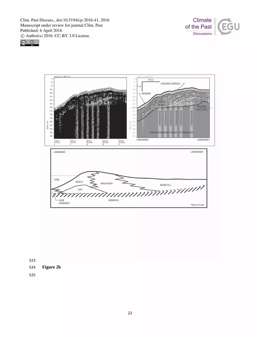
Figure 2b. GPR line A9 was acquired from the lake shore to the highest point on the berm. 507
Internal structures show characteristics of a beach environment over a spit complex. Top left 508
panel, raw data; top right panel, interpretation. The lower panel shows a conceptual model based 509
on composite GPR profiles suggesting a lower lake facies with spit facies underlying beach, 510
washover and basin fill facies. 511
Figure 3. Equivalent dose distributions for the LLL samples, illustrated as radial plots. The 512
shaded populations in each case represent the dominant age peaks; the lines illustrate the other 513
identified populations. 514
Figure 4. Rose of 9am wind direction vs wind speed in km/hr at Guyra Hospital, 1332 m AMSL 515
(Bureau of Meterology, 2014). 516
517
Clim. Past Discuss., doi:10.5194/cp-2016-41, 2016Manuscript under review for journal Clim. PastPublished: 6 April 2016c© Author(s) 2016. CC-BY 3.0 License.

20
518
Figure 1 519
520
Clim. Past Discuss., doi:10.5194/cp-2016-41, 2016Manuscript under review for journal Clim. PastPublished: 6 April 2016c© Author(s) 2016. CC-BY 3.0 License.

21
521
Figure 2a 522
Clim. Past Discuss., doi:10.5194/cp-2016-41, 2016Manuscript under review for journal Clim. PastPublished: 6 April 2016c© Author(s) 2016. CC-BY 3.0 License.
22
523
Figure 2b 524
525
Clim. Past Discuss., doi:10.5194/cp-2016-41, 2016Manuscript under review for journal Clim. PastPublished: 6 April 2016c© Author(s) 2016. CC-BY 3.0 License.

23
526
Figure 3 527
528
Clim. Past Discuss., doi:10.5194/cp-2016-41, 2016Manuscript under review for journal Clim. PastPublished: 6 April 2016c© Author(s) 2016. CC-BY 3.0 License.

24
529
Figure 4 530
531
Clim. Past Discuss., doi:10.5194/cp-2016-41, 2016Manuscript under review for journal Clim. PastPublished: 6 April 2016c© Author(s) 2016. CC-BY 3.0 License.


