Embed Size (px)
Citation preview

Younger Dryas end moraines between Hardangerfjorden and Sognefjorden, Western Norway I N G t AARSfITH AND JAN MANGRRUD
.4ai-seth, I . c;C Mangel-ud, J. 1974 06 01. Younger Dryas cnd moraines between Hardanger- fjordcn and Sognefjot-den. Western Noi-way. Roreus. VCI. 3, pp. 3-22. Odo. ISSN 0300-9483.
End moraines (called the Herdla Mot-aines) fl-om the Younger Dryas Stadial ai-c mor- phologically mapped along the westet-n coast of Norway, from Hardangerfjorden to north of Sognefjoi-den. The submarine position of the moraines are found by means of a con- ventional echo sounder. Stratigraphical studies with many C" datings are used for age deter-mination, giving Late Youngei- Dryas (10,000-10,500 C" ye B.P.) for thc Herdla Moraines. The moraines are correlated with the Rn-Salpausaclka Moraines. Isobases fol- the Youngel- Di-yas arc obtained from marine terraces foi-med contemporaneously with the moi-aincs.
I t r ~ e Aarserli ti Jut, Muiigerritl. Grologisk itrstifritt. Avd. R.. Olof Ryesvri I Y , 5014 Brrgeti ~ J i r i w r s i f e ~ r i , Norwlry, 171h December, lY73.
BOREAS . .
, , '
The largest end moraines in Eastern Norway arc the Ra Moraines, which according to 0 4
datings originate from the Younger Dryas Stadial (references in Mangerud 1970, Fig. 10). Thcsc moraines have been known for more than 100 years and from many later investiga- tions (0. Holtedahl 1953: 647-658). Since the discovery of the Ra Moraines, geologists have tried to find moraines of the same age in other parts of Norway. In Hordaland the Ra Mo- raines have been correlated with several dif- fcrcnt moraines, such as the Eidfjord Moraines (Kaldhol 1941), and the Odda Moraines (Undis 1944) at the very head of Hardanger- fjorden, the Romarheim and Eidsland Mo- raines (C. F. Kolderup 1908; N. H. Kolderup 1926) further north-west, the UIven and Herdla Moraines (Undiis 1963; Mangerud 1970) even closcr to the coast; location outside the coast at Blomoy has also been discussed (H. Holte- dahl 1964). Several methods have been used for the correlations; all of them, however, were uncertain until the C14 dating was in- troduccd. We therefore will not discuss all the older correlations.
Before we started the investigations, the most recent attempt to map the Younger Dryas end
moraines in Western Norway was by U n d i s (1963). W e were sceptical about some of his conclusions because of the lack of datings out- side the supposed Younger Dryas moraines, and because several of the deposits mapped by him are very small and are, in our opinion, not ice-front deposits. W e have to revise the inter- pretations of U n d i s (1963) in many places, but he is nevertheless right in his main con- clusions concerning the position of Younger Dryas end moraines in this area.
The position of the Younger Dryas and other end moraines in Hordaland has remained unknown until recently because of two main problems:
First, most of the end moraines are very small, 1-5 m high, and in many areas the ice- front sediments do not have constructional forms a t all. Obviously such deposits are very difficult to map for long distances, especially in forested and mountainous regions like parts of the present area. The area is also dissected by numerous fjords and sounds, increasing the problem of correlation.
The second main problem has been the dating of moraines. Because the mapping of end moraines is so extremely difficult, the

BOREAS 3 (1974)

IJORI AS 3 (1974) Younger Drytis end rnorairzes 5
correlations with other areas depend strongly upon datings. Introduction of the radiocarbon mcthod provided a new solution, and by com- bining radiocarbon dating with other strati- graphical studies we have achieved relatively good results.
Methods The moraines were first mapped on land. However, for ncarly half the distance they are found below sea level. We therefore developed a simple method for investigation of the mo- raines at the sea floor.
Suprurnurinc army The whole area is covered by vertical air photos (scale ca. I : 15,000). In our opinion a satisfactory mapping would have been nearly impossible without the air photos, because as previously mentioned the moraines in most of the area arc very small and discontinuous, and they partly occur in forests and steep mountain-
Wc have also studied the moraines from a small airplane. The main advantage of this method was a general view of the moraines (at ful l length ca. 200 km) and their topo- graphic a I positions .
Both of LIS have been doing field work con- cerning Quaternary geology in this area for several years, and have investigated most of the moraines in some detail. Glacial striae are extensively mapped, some of them are indi- cated in Fig. 1, and the youngest directions have bccn used for the reconstruction of the glacier-front.
The most important results of the field work havc been the stratigraphy of the few sections in the moraines, and the stratigraphy of the sediments in the areas inside and outside the moraines. These investigations havc provided material for C'4 datings, and thereby an in- dependent method for correlations of the moraines within the area, and the only satis- factory mcthod of corrclation to other areas i n Scandinavia.
s I 0 p es .
Submarine areas The complex landscape with fjords and straits dissecting the landmass makes a correlation of supramarine moraines difficult. Attempts to trace submarine moraines o n continental shelves by conventional echo soundings (King 1967, 1969) encouraged a similar investigation in the fjords of Western Norway. The fact that the largest ice-front deposits are found below the marine limit also indicated the possibility of finding big submarine accumulations.
The echo sounder used is a 18 kHz Sirnrcid Scientific Sounder EK. This sounder has a depth-independent amplifier in addition to a pcnctrating effect in the sediment. The relative low pulse power output (1 kW) limits the sub-bottom penetration to clay and silt. The beam width (13" ~ 2 0 ' ) reduces the quality of the recording at greater depths, but gives inter- pretable readings down to ca. 300 m.
Several methods of using the sounder were tested. In some areas bottom samples were taken to calibrate the recordings. The first attempt was made in Fusafjorden (Aarseth 1971) where a geological map (Fig. 3) was constructed on the basis of a dense pattern of soundings. As can be seen from examples of recordings from this fjord (Fig. 21, the moraine ridge differs clearly from the ridges mainly consisting of bedrock. The moraines havc a smooth surface, while the bedrock outcrops have a jagged topography. Grab sampling gave boulders, gravel, and fine sand on the mo- raines, but no samples were obtained from the
ngs from the echo soundings show a n increasing acoustic transparency of the sediments down the distal slopes of the moraines. This was interpreted as a grading of the sediments which was confirmed by grab samples giving finer sediments down-slope. The maximum inclination of the distal slopes varies f rom 12 to 17 degrees. Small basins and flat areas distal to the moraines gave the deepest echo penetration, 15 m, without reaching bedrock.
Continuous seismic profiling by the Seis- mological Observatory in Bergen showed that the maximum thickness of the sediments in the deepest basins of Bjornafjorden is ca. 100 m (Sellevoll, pers.comm.). Most of this is thought to be glaciomarine sediments, deposited in Allerod and Younger Dryas time.

HOREAS 3 (1974) 6 lngc Aarseth and Jan Mangerud
E W
DEPTH m MORAINE RIDGE
A
U 5 0 0 m
S W NE
0 500 m -4 C
I3ORI:AS 3 (I 974) Younger Dryas end moraines 7
Compact bottom with rough topography (Mainly bedrock)
- Ikm Land area
Soft bottom with transparent echogram (Clay-Silt) Compact bottom with smooth or undulating surface (Ti I I- Sand-Gravel)
&\-\ Ice-contact slope
A A Block concentration on the shore
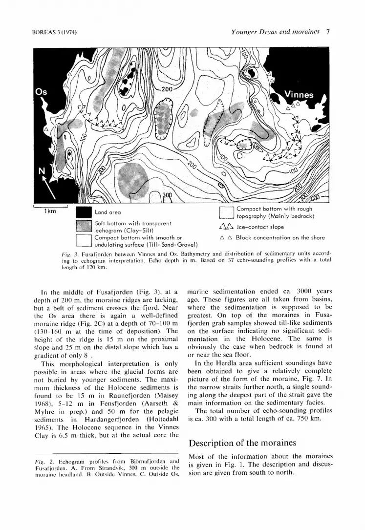
b'ig. 3 . Fusafjoi-den between Vinncs and 0 s . Hathymetry and disttihution of sedimental-y units nccord- ing to echogram intei-pretation, Echo depth in m. Based on 37 ccho-?,ounding profiles with a total length of 120 km
I n the middlc of Fusafjorden (Fig. 3 ) , at a depth of 200 m, the moraine ridges are lacking, but a belt of sediment crosses the fjord. Near the 0 s area there is again a wcll-defined moraine ridge (Fig. 2C) at a depth of 70-100 m (130-160 m at the time of deposition). The height of the ridge is 15 m on the proximal slopc and 25 m on the distal slope which has a gradient of only 8 .
This morphological interpretation is only possible in areas where the glacial forms are not buried by younger sediments. The maxi- mum thickness of thc Holocene sediments is found to be 15 m in Raunefjorden (Maisey I%%), 5-12 m in Fensfjorden (Aarseth & Myhrc in prep.) and SO m for the pelagic sediments in Hardangerfjorden (Holtedahl 1965). The Holocenc sequence in the Vinnes Clay is 6.5 m thick. but a t the actual core the
Fig . 2 . Echogram pi-ofilc\ f rom Bjotnafjorden and Fusnljot-den. A. From Strandvik, 300 m outside the moraine headland. B. Out\ide Vinncs. C. Outside 0 s .
marine sedimentation ended ca. 3000 years ago. These figures arc all taken from basins, where the sedimentation is supposed to be greatest. On top of the moraines in Fusa- fjorden grab samples showed till-like sediments on the surface indicating no significant sedi- mentation in the Holocene. The same is obviously the case when bedrock is found at o r near the sea floor.
In the Herdla area sufficient soundings have been obtained to give a relatively complcte picture of the form of the moraine, Fig. 7. In the narrow straits further north, a single sound- ing along the deepest part of the strait gave the main information on the sedimentary facies.
The total number of echo-sounding profiles is ca. 300 with a total length of ca. 750 km.
Description of the moraines Most of the information about the moraines is given in Fig. 1. The description and discus- sion are given from south to north.

St r at cit ype.5
Frye & Willman (1962) proposed the use of land forms for formal stratigraphical classifica- tion. This is widcly used, especially for strand- lincs and end moraines. There exists, howcvcr, no general agreement about its use and, among others, Flint (1971) argues against the use of end moraines as stratigraphic units. In our opinion (blangerud 1970, 1973) end moraincs provide a sound basis for stratigraphical clas- sifications in glaciated areas, independent of other classifications, for instance, lithostratig- raphy. A morphostratigraphic classification should not bc in opposition to thc principles of the Int. Subcom. Strat. Class. (1970a, b; 1971a, b; 1972).
I n this paper we use Moraine - with a capital M - as a morphostratigraphic unit term. I n Norway the term substagc is widcly ~iscd with the same meaning (e.g. Anundsen 1972; Follestad 1972). This should, however, be avoided, as substage is a chronostratigraphic uni t tcrm.
Wc havc mapped thc end moraines for approximately 200 km in very rugged topog- raphy. Ncvcrthcless we find the correlations certain enough to use one term (Hcrdla Mo- raines) for the whole area. T h e dcscription of the stratotype, Herdla, is given below, in con- nection with thc description of the end mo- raines.
Hardangcrfjorden - Strandvik
The maximum cxtension of the glacier in Hardangcrfjorden during thc Younger Dryas Stadia1 is marked by the large end moraine crossing the island of Halsnoy (Fig. 11) (Undis 1963; H . Holtedahl 1967; Follestad 1972). The fjord sill west of Halsnoy controlled the posi- tion of the glacier front during this readvancc (H. Holtedahl 1967: 194).
UndHs ( 1963: 12) has describcd distinct mo- raines i n the central part of Tysnes island. Hcrc a branch of the Hardangerfjorden glacier has been moving up-valley, causing gla- ciolacustrinc scdiments to be interbeddcd in the till. Thc steep mountain sides on the eastern side of Tysnes have no traces of a glacier margin, but o n thc slopes down to Bjiirnafjorden latcral moraines occur both abovc and hclow the marine terrace at Hagen (68 m a.s.1.). In thc dcepest part of Bjorna-
fjordcn (460 m deep), no moraine-like ridges are found. The glacier front was most likely floating, as the depth at that time exceeded 530 m. The floating glacier resulted in an extensive calving, which again caused a con- verging ice movement in the fjord basin, with ice coming from north, east, and south (Fig. 1). The two last directions arc the results of ice flowing f rom the Hardangerfjord glacier, where the most important ablation factor, calving, was limited at the grounded glacier front.
111 Strandvik the moraine forms a small headland (Fig. 4) of clayey till, protected against marine abrasion by large boulders. This ridgc, 15 m high near the shore, can be traced out on the submarine platform where it forms a 50 m high ridge (with a bedrock core?) with boulders on the surface (Fig. 2A). The supra- marine moraincs can be traced almost con- tinuously up to 300 m a.s.1. (Fig. 4), and a nunatak moraine is situated on a 480 m high mountain north-east of Strandvik. In this arca the supramarine moraines usually are small, 1-3 m high, but distinct from the gcncrally bare bedrock surface. The very steep gradient, 100 m/km for the last 4 km, is due to the ice fall in the nunatak arca and to the change in flow direction from south to west near the front. A small glaciofluvial terrace marks the marine limit in Strandvik a t that time (77 m a.s.1.).
Vinnes - Fusafjorden On the Fusafjord side of the peninsula, the lateral moraines can be traccd from Vinnes along the mountain side up to 340 m a d . They are lacking on the northern side of the mountain. The gradicnt of thc fjord glacier is SO m/km for the last 5.5 km.
UndHs (1963: 13) interpreted the moraines at Vinnes as having been deposited f rom thc east by a glacier in Bjiirnafjordcn. The Vinnes Clay, 0-1 km southeast of the moraines was, according to UndHs, washed out from the moraines after deposition. The C14 dating by Mangerud ( I 970) from Vinnes (T-594, 10,970 f 1 SO) made this doubtful.
A stratigraphical analysis of a 27 m deep core in thc Vinnes Clay (Aarseth 1971) shows a continuous sedimentation from Allcrijd time. The lower half of the core, consisting of clayey silt and silty clay, is thought to be dcposited

/.'ig" 4. Air photo of Strnndvik towards NE. T h e headlarid made up of till in the foreground form.: thc moraine, T h e furthct- courw of the motmine i s indicated (dotted). T h e nunatak moi-aine is in t h e uppci- right (m). The location of t h e let-race indicating the marine limit (77 m a.s.1.) is marked in the center o f the photo. Dii-cction of glnciet- f l o w i s indicated by at-Iow. Photo by Fjelllunger Wideroe A/S, Scpt. 1950.
before the rcadvancc in the Late Younger Dryas. This gives a mean rate of sedimcnta- tion o f approximately 8 mm/ycar. Above this sequence lies a zonc containing the high-arctic mollusc Port /onc / i~ / trrcfictr. The sediments bc- come more varicd, containing layers o f graded sand-silt. One of the graded layers contain leaves of Brtuln 11(111(1 and S d i x herhtrcerc together with mosses, some of which today only grow in alpine regions (Ovstedahl & Aar- seth i n prep.). These macrofossils all indicate high-arctic conditions, and the graded layers are thought to have been dcpositcd by floods from the glacier margin. The coarser material was dcpositcd at the glaciomarine delta a t Dal- land (71 m a.s.1.).
Oedometer tests from two horizons in the core show normally consolidated sediment. This, together with thc continuous sedinienta- tion o f the Vinnes Clay and the C14 dating mentioned above, corroborates the statement
that thc Vinnes Clay lies distal to the Vinnes Moraines. If we consider the striac in the area, thc southern striation in Fusafjorden dis- appears only a few hundred meters north of the Vinnes Moraine and is probably con- temporary with the moraine. The moraines in Fusafjorden are described above in the sec- tion on submarine areas.
0 s urea The Quaternary deposits are more extensive i n the 0 s area than in most other coastal areas in Hordaland. The dcglaciation of 0 s has therefore been discusscd by several authors, most recently by Undis (1963), H. Holtedahl (1 Y64), and Mangerud (1 970).
I n Fig. 5 a reconstruction is given of the ice front during the Late Younger Dryas. This reconstruction is based on morphologically evident ice-contact slopes and end moraines,


F i g . 6 . Air photo of Fanafjorden and Fand'jellet. The lateral moraine in the noi-thcrn slope of latiafjcll i \ indicated (dotted). Note the mot-c extensive till covet- on thc i n d c (left hand) of thc moraine comp:ircd with the outside. The approximate position of Mai-inc l imi t (50 m a.s.1.) i b ill- dicatcd. Fi-om that point the (calving) ice f r o n t C I - O S S C ~ the fjord, and the d i m e n t s i n the foi-cgi-ound (Miltle) a I e part\ of the ice-fi-ont depoyits on the noIthern side of the fjord. Photo by Fjellanger Wideriie AIS, Aug. 1954.
while the maximum advance during Late Younger Dryas no doubt reached a few hun- dred meters further south and west.
The directions o f the glacial striae south of thc end moraines (Fig. 5 ) are oblique to the direction of Fusafjorden, indicating that during the deglaciation in the Allerod the glacier flow did not adjust to the topography of the fjord, probably because the deglaciation was very rapid. This provides an independent method of limiting the Younger Dryas advance to the boundary between the two directions of striae.
In 0 s thcre was a confluence of two glaciers, one in the 0 s valley from Softeland and one in Fusafjordcn, separated by a large nunatak around Borgafjell (Fig. 5 ) . The subglacial meltwater from the 0 s valley glacier did not
/ , ' i ~ . 5 . i';ilcogcogr~iphical map of the 0 s ai-ea (west o f Fuwfiordcn, Fig. I) during Late Younger Dryas.
reach the sea to the south, at Osoyri, but spilled out from the western flank of the lobe, a t Ulvensletta. The reason for this was prob- ably that the pressure from the glacier in Fusafjorden caused a westward sloping of the glacier surface.
According to seismic investigations, the maximum thickness of the glaciofluvial sedi- ments a t Ulvensletta is 34 m, while in most areas the thickness is considerably Icss. This sediment basin had a narrow connection with thc sea towards SW (Fig. S), where most of the fine-grained sediments were transported to the sea. T h c surfaces of the deposits form nearly horizontal terraces with an elevation of approximately 58 m a d . at Ulvensletta and 57 m a d . at Grindavoll, indicating that the whole deposit was built up to sea level in the Late Younger Dryas. These figures are used for the construction of the isobase map (Fig. 1 I ) .

IWRF,AS 3 (1974)
Exposed bedrock
Glacial sediments
redeposited 1
A A Boulder belts
i :> Ice-contact slopes
Main te r race- escarpment
3 2 Marine l imi t
u . . . on land, ( Partly
r.
+*
wvvw
I - Echo sounding profiles at Fig.9
N
T - 0 1 km
k ' i ~ . 7. Simplified glacial map ol the Herdla nrca. Contoui-s only helow wii levcl. Depth it1 metel-s. T h e c l c ~ i i t i o ~ ~ on land docs not exceed SO m iii t h e map area (Fig. 8). In thc \hallow ai-ea hctwccn the rioithel-n pat^ o f Herdla and Lille Angoy, mainly marine \atid i y louiid oil t h e sea flooi-, assumed t o he I edcpo4ted glacial .;ctliment\.
0 s - Hcrdla Between 0 s and Lyscfjordcn (Fig. 1 ) only small dcposits without clcar ice-contact slopes are found.
At Fanafjell mountain, between Lysefjordcn and Fanafjorden (Fig. l ) , are small, but very prominent latcral-moraines, especially along the northern slope (Fig. h). Surprisingly enough,
U n d i s (1963) does not seem to have noticed thcse moraines, and he assumcd that the posi- tion of the ice front was a little further west. Inside thc moraines a (discontinuous) cover of till is found, with an abrupt transition to nakcd bedrock outside the moraines (Fig. 6). Obvi- ously the till sheet was deposited simuita- neously with the moraines, thus proving that the advance did not reach further west. The

Fig . 8. Ail- photo of Herdla towatds noi-th. The dai-k lol-ests i n the ccnti-a1 part o f Herdla arc mainly the hedi-ock areas, indicated on the m a p (Fig. 7). The cultivated at-eas :iIc thc glacial xdiment\ . The condition\ i t 1 the loiegi-ound. on AskBy. a tc typical 101- mo\t o f the region discu\wd in this papci-: Hare bedrock with sonic \cdimcnts (including peat) in the depressions only. Photo hy Fjellanger Witlel-dc A/S, Aug. 1961.
latcral-moraines slope 250 m for a distance of 3 km, indicating a stccp glacier-front.
I n the Fanafjord - Raunefjord - Agotnes arca (Fig. I), some moraines have been found, both o n land and by echo sounding i n the fjords, and even though the moraines arc not continuous, the main trcnd should be correct.
Most problematic is the position of the glacier front i n Hjeltefjorden between Agotnes and Herdla. Dated Alleriid sediments a t Blom- v ig and Agotnes (Fig. I ) provide clear evidence that the glacier did not reach these islands west of Hjeltefjorden. N o end moraines are found at the islands, neither west nor east of Hjclte- fjorden. The trends of the moraincs to the north and south indicate that the ice front was situated in. o r very close to, Hjeltefjorden. We have obtained ca. 30 echo-sounding profiles i n the fjord. The soundings are, however, difficult t o interpret because the fjord is up to 315 m deep and the bedrock topography of
the bottom is very rough. Based on the b’ w e n observations, and in accordance with the direc- tions of the glacial striae, we assume that the glacier has been floating in Hjcltefjorden, causing a fairly straight, calving glacier front.
Hrrdlu urea The island of Herdla is, morphologically, the most prominent ice front deposit in western Hordaland, and has been recognized and dis- cussed as such for a long time (C. F. Kolderup 1908; N. H. Kolderup 1938; Undis 1963; Mangcrud 1970, and others). We use Herdla as the stratotype for and origin of the name of the morphostratigraphic unit, the Herdla Moraines. More detailed investigations are now going on, and we will therefore give a relatively brief description.
The island is situated across the outer part of Herdlefjorden (Figs. 1, 7, 8), leaving only

3 Km 2 Km 1Km OKm
- 50
- I O O r n
lOOm
NW
W h E m
W .............. -- ...........
............
............................
44 Assumed ice-contact slope Assumed bedrock 20'Angle of slope
/ i y . (4. I:cho-wunding pi.olilc\ I'rom the Hel-tll;i :irfii. For location scc Fig. 7.
narrow sounds bctwccn Herdlefjorden and Hjeltefjorden. Bedrock occurs in parts of the island (Fig. 7), while large areas arc covered by unconsolidated sediments. The surfaces of the sediments are mainly terraces of different elevations, the highest being a slightly sloping terrace ca. 34 m a.s.1. (Fig. 7). This possibly represents the marine limit and the sea level of the time of deposition (Late Younger Dryas). For the construction of the isobases (Fig. I I ) , however, the elevation of 32 m, obtained from a marked beach ridge, has been used.
Toward the east are very clear ice-contact slopes. These arc directly observable from land, but are obviously even more prominent below sea Icvcl, as can be seen from the echo- sounding profiles (Fig. 7 and 9). On profile I l l (Fig. 9) a smooth sediment slope down to
the depth of 130 m can be seen, but, on the basis of the present observations, i t is impos- sible to determine the border of the real con- structional ice-contact slope. N o doubt, the ice-contact slope is more than SO m high below sea level in several places, including profiles, I , I t and 111 (Fig. 9).
The sediments and stratigraphy are so far known from a few sections and borings. The maximum observed depth is ca. 30 m, but will probably turn out to be considerably more. I n the higher terraces the main sediments arc glaciofluvial and glaciomarine. Till is seen in one section in the proximal slope. The block belts indicated a t the map (Fig. 7) are sup- posed to have been either deposited directly from the glacier, or most probably to be the erosional remnants of till. Due to the pattern,

F E N S FJ ORDE N SE NW SANDOY 0
200
LOO
600 600
I I I I I I I - 800 35 Krn 30 25 20 15 10 5 0
800 I I I I I I 1 8 0 0 35 Krn 30 25 20 15 10 5 0
8001
Fig. 10. Longitudinal profile of Fensfjorden, h a d on 45 transversal echo sounding\. Echo depth i n m. The moraine a t Sandoy, immediakly n o r t h of the sill, is indicated.
we assume they indicate the ice front position in certain periods. During the Holocene an extensive littoral erosion and redeposition of the glacial sediments took place, as indicated by the lower terraces and sediments.
So far only one radiocarbon date has been obtained. I n the western part of the island (Fig. 7) large specimens of Myci truncata were found in shelly sand immediately above bed- rock, close to the present day sea level. Above the sand is ca. 20 m of glaciomarine sedi- ments, mainly silt, and on the top 8-10 m of coarse glaciofluvial gravel. The dating gave the age (T-1049) 10,540+ 130 B.P., indicating that the whole sequence above was deposited during the Upper Younger Dryas.
The deposits at Herdla continue below sea level northwards to Lille Agnoy (Fig. 7) and Holsnoy. The submarine deposits here arc possibly as thick as the sediments a t Herdla. Probably Herdlefjorden has drained meltwater from extensive areas, depositing the large amount of glaciofluvial and glaciomarine sedi- ments a t the ice front.
Glaciomarine terraces and end moraines are also found a t the island of Holsnoy, indicating the position of the ice front. Just inside the moraines is a more than 300 m high mountain (Fig. I ) , without lateral moraines. The glacial striae (Fig. 1) indicates that the ice first reachcd the moraines f rom NW, while later
the ice flow (from SW) south of the mountain was the more important.
Mungersfjorden - Fensfjorden The area between Mangersfjorden and Fens- fjorden is mainly a part of the low-lying srrundfklt, most of which was submerged during this readvance. The moraines are therefore mainly made up of glaciomarine silt and clay, consolidated by the pressure of the ice. During the postglacial emergence these moraines were exposed to marine abrasion. This resulted in resedimentation of silt and clay in the depres- sions. In the Fosnoy area the moraines consist of two parallel ridges, at most 1 k m apart.
The submarine moraines in this area are also very small. The straits have usually two or three ridges, 5-10 m high. 111 the 400 m deep Mangersfjorden, the bottom topography changes westwards from a narrow trench to a wide sediment basin at the supposed margin of the glacier.
Fensfjorden has been subject to a special marine geological investigation (Aarseth & Myhre in prep.). A longitudinal profile of the fjord is shown in Fig. 10. The 385 m deep sill south of the island of Sandoy most likely has a bedrock core, but the morphology indicates a considerable sediment cover. The sill is located between well-defined moraines on land

both to the south and north, and the sediment cover on the sill is therefore probably a part of the end moraine.
Sogncfjorden ureu
The moraines on the island of Sandijy (Fig. I ) are very distinct both above and below the marine limit which is marked by an abrasion terrace at Anneland, 35 m a.s.1. The moraine drops 200 m the last km down to thc terrace. The same stcep glacier front is also indicated by the moraines on Mj6mna.
The clear morphological evidence of an ice front deposit xiddenly disappears north of this island. Only small boulder accumulations occur on some of the islets. The sounds in between have no marked traces of an ice front. The same lack o f clear end moraines also characteriscs the area just north of Sogne- fjorden. According to Undis (1963: 23) mo- raines on Ytre Sula and west of Steinsund (Fig. I I ) belong to this icc advance. This is a several kilometer broad belt of boulders with only a few small ridges. Thc first sign of a well- defined ice front deposit north of Sogne- fjorden is a 7 km long, continuous end moraine along the mountains o f Sula, from 360 m a.s.1. down to sea level.
The discontinuity o f the moraines around the mouth of Sognefjorden is most likely a result of an unstable glacier front. The 275 m deep sill southeast o f Ytre Sula is thought by U n d k (1963: 23) to be the R a Moraine i n Sognefjorden. Echo soundings from the area show a sediment cover ovcr the threshold, but the lack of continuation ashore makes the assumption by UndBs doubtful. Most likely this accumulation was deposited as a reces- sional moraine at the fjord entrance while the glacier obtained equilibrium during the Al- leriid deglaciation.
The extensive clay deposit north of Dals- fjorden with P o ~ t l ~ t i d i ( i rrrcricn (Kaldhol 1941) indicates a glacial environment at the time of deposition. The glacier front must have been situated south of the fjord where large end moraines are found at Fure. There are two parallel ridges, the innermost can be traced for a distance of 10 km, partly as a submarine ridge. An abrasion terrace at 27 m a.s.1. marks the marine limit i n this area.
The change i n ice front direction north o f Sognefjorden (Fig. I I ) was probably due to
the dominating glacier i n this fjord, which caused the ice movement through the sounds north-east of Sula.
C14 datings The dated materials arc in nearly all the localities marine shells. For the method the reader is referred to Mangerud (1972a). All agcs are given i n conventional (TI,,= 5570) radiocarbon years B.P.
Fossil-bearing tills have been known in the Bcrgen area for a long time (Rekstad 1900; C. F. Kolderup 1908). The first C14 datings of the tills were obtained by U n d k (1963) and H. Holtedahl (1964) and gave Allerod and Younger Dryas ages, thus proving that the Younger Dryas end moraines had to be found west of the dated localities. Later many more datings giving the same ages were obtained from till and sub-till sediments (Fig. 1 ) (Mange- rud 1970, 1072b, Aarseth 1971). The geo- graphical distribution (Fig. 1) of the overridden sediments indicates a grcat ice advance during Younger Dryas (Mangcrud I970), and obvi- ously the end moraines must be situated out- side the area of overridden sediments. Theo- retically, however, the moraines could be situated far outside the known localities of these sediments, and a position outside the coast ( H . Holtcdahl 1964) was a very realistic al tern a t ivc.
At Blomiiy (Fig. l ) , Mangcrud (1970) ob- tained sevcral datings of Allcrod age from a bog undisturbed by ice, giving clear evidence that the Younger Dryas advance did not reach that island. H e (Mangerud 1970) also obtained a dating of museum specimens from the Vinnes Clay (Fig. I ) , giving the age (T-594) 10,970+ 180 B.P. and Aarseth (1971) found that thc clay had not been consolidated by ice. Also at Agotnes (Fig. I ) a dating of marine sediments (T- 1023, 12,250 * 150) undisturbed by ice has been obtained. Finally we can mention the prcviously discussed dating from Herdla (T- 1049, 10,540* 130), which indicates that the Herdla Moraine is from the Younger Dry
Fig. 1 shows that there is only a narrow zone between the area with sediments over- ridden by the ice advance during the Younger Dryas and the localities with sediments un- disturbed by the same advance. In this narrow zone we have mapped the Herdla Moraines,

UOREAS 3 (1974)
6
Fig. / I . lwhasc map of thc Youngci- Dryas sca level in thc area bctween Hardangct-- Ijoi-den and Dalsfjot-den. The mol-ainc south of Hardanget-- fjot~dcti i s according 10 Folle- \tad ( I 972).
2 - Doreas 1/74
Younger Dryus end moraines 17

and although these in most places are small and not fu l ly continuous, we d o not doubt that they represent the Younger Dryas moraines between Hardangcrfjorden and Sognefjorden.
The next problem is to obtain more precise dating within the Younger Dryas of the Herdla Moraines. The northernmost dating (Fonnes, Fig. I ) was obtained from sediments inter- preted to be glaciomarine clay, thus indicating that the ice front was approaching at (T-1168) 10,770+ 140 B.P. The dating from Herdla indicates that the whole moraine was deposited after (T-1049) 10,540+ 130. In the 0 s area (Fig. 1 ) ages of (T-752) 10,790+110 and (T-229) 10,150+ 300 were obtained from tills close to the end moraines, and (T-304) 10,050* 250 from clay overridden by the ice, showing that the ice reached 0 s very late i n the Younger Dryas. Further south (Lunde, Fig. 1 ) (T-847) 10,570* 100 was obtained from a till.
Assuming that the Younger Dryas Stadia1 lasted from 10,900 to 10,000 C'4 years B.P. (Mangerud 1970), these datings clearly indicate that thc Herdla Moraines are of Late Younger Dryas age. Actually there is a possibility that the glacier was advancing to the very end of the Youngcr Dryas and did not reach equilib- rium until the climatic amelioration.
ble interpretation of the dates st reached thc position of the
moraines i n the northern area - compare the interpretation of the date from Fonnes - and later the position in the more southern area, at Herdla and especially 0 s . This interpretation is in accordance with all datings obtained so far, and is also glaciologically reasonable. North of Fcnsfjorden are high mountains, continuing eastward. Analysis of glacial striae indicates that these mountains have been an important accumulation area, influencing the ice flow south to Fusafjorden. It is therefore vcry likely that the glaciers reached the Fens- fjord area before the coastal areas further south. This interpretation is, however, based on very few datings, and should only be re- garded as a reasonable hypothesis.
So far the younger border of the Herdla Moraines has not been discussed. Mangerud and his students have obtained some pollen diagrams from Preboreal sediments inside the moraines, including a radiocarbon dating giving (T-1487) 9760k 180 B.P. (Aa, pers.comm.), which indicate that the deglaciation started early in the Holocene. The head of Hardanger-
fjorden was deglaciated before 9720 + 330 B.P. (T-585) (Anundsen & Simonsen 1968), and the head of Sognefjorden before 9790 + 160 B.P. (T-901) (Bergstrom i n prep.). The retreat of the ice front from the coastal areas to the head of the fjords necessarily took some time, and these datings therefore indicate that the retreat from the Herdla Moraines must have started very close to 10,000 B.P.
Sea level In Western Norway the problem of shoreline displacement during Late Weichsclian and Holocene time has been difficult because of the uncertainty of the isobases. In the Sogne- fjord area the direction of the isobases has been supposed to be N-S (along the coast) by several authors (Brathole 1951; Kyrkjebo 1953; Carlsson 1960). UndHs (1963) constructed the 60 m isobase south of Bergen, but due to some obviously wrong interpretations he obtained different directions (N 17 'W-N 34' W) in dif- ferent areas. In a previous paper (UndHs 1945) just north of Bergen he used a direction of N 2 ' W without discussing it.
The latest attempt to construct a shoreline diagram in a part of this area is by Follestad (1972). His assumption of the three base local- ities in the outer part of Hardangerfjorden as contemporaneous marine limits must be re- jected. The terrace at Skinevik, 83 m a.s.1. is a pronounced wave-cut platform i n the moraine, representing the Younger Dryas sea level (Anundsen 1972: 13). The terrace at Eik, 83 m a.s.l., is very small, and a marine formation is not obvious. I n addition it is situated 20 km inside the Younger Dryas moraines at Halsnoy. The terrace at Onarheim, 70 m a.s.l., is known as a bedrock tcrracc (Kaldhol 1941), probably the upper edge of the Strandflat. This terrace is therefore definitely older than the events discussed here.
The terraces used for construction of the present isobase map are clearly connected with the moraine itself, either as abrasion terraces on the distal side of the moraine or as ac- cumulation terraces which were built up by drainage from the glacier front. The various localities are mentioned in the description of the moraines. The levels refer to the present day mean sea level. Most of the terraces are relatively flat, but some have slightly undulat-
BOREAS 3 (1974) Younger Dryus end rnoruirzes 19
ing surfaces. The heights are therefore given indicated according to Marthinussen (1961) in whole meters a5 the variation in level is of and Andersen (1968), in Sweden according this order. to Lundqvist (1965) and in Finland according
The Herdla Moraines have a general course to Donncr (1965) and Hyvarinen (1973). along the coast, and over long distances they However, several problems appear concern- are situated o n the low-lying Strandflat, and ing a more precise chronostratigraphical cor- very few terraces are found. Only in the relation of the Younger Dryas end moraines: southern part of the area can both the direc- tion of the isobases and the gradient of the shorelines be constructed. This gives a dircc- tion o f N 13 W and a gradient of 1.4 m/km i n Bjiirnafjorden area (Aarseth 197 I ) .
In the Nordfjord area, just north of the area covered by Fig. 11, the gradient of the well- defined Main shore line, correlated to the Younger Dryas ice advance, is 1.1 m/km (Farcth 1970). For construction of the isobase map (Fig. 1 1 ) an interpolation of the gradient between these two areas is necessary. Thus the gradient is assumed to drop from 1.4 mikm in Bjiirnafjorden to 1.2 m/km in Dalsfjordcn. This agrees well with the elevation of the two terraces i n this fjord, at Fure (27 m a.s.1.) and Dale (47 m a.s.1.).
Correlations The dating of the Herdla Moraines to the Younger Dryas makes the correlation with other Younger Dryas moraines more or less obvious, and this correlation was cstablished by Mangerud (1970).
At present ;I morphostratigraphical correla- tion i s also possible, as the moraines arc mapped nearly continuously south of this area (Andcrsen 1954, 1960; H. Holtedahl 1967; Anundsen 1972; Follestad 1972) to the Ra Moraines in Eastern Norway. The morpho- stratigraphical correlations of the Ra Moraines, the Middle Swedish End-moraines (Lundqvist 1965) and the SalpausselkE Moraines i n Fin- land (Donner 1965) are also generally accepted.
We have compiled a map of the Younger Dryas end moraines in Scandinavia (Fig. 12). The end moraines in Southern Norway are indicated according to compilation in Mange- rud (1970), with additions from Anundsen (1972) and Follestad (1972) in the area south of Hardangerfjorden, from the present paper in the area between Hardangerfjorden and Sognefjorden and from Fareth (1970) in the Nordfjord area (for location, see key map, Fig. 1 ) . The moraines in Northern Norway are
( I ) The end moraines, even though continuous, are not necessarily deposited simultaneous- ly in their full length.
(2) Dating of end moraines is often difficult. In fact surprisingly few C'4 dates are closely related to the Younger Dryas end moraines in Scandinavia.
(3) The level of correlation is very precise. The duration of the Younger Dryas is 800-900 years, and the discussion is now concerned with ascertaining in which purt of the Younger Dryas the different moraines were formed. We arc therefore very close to, or beyond, the precision level of C14 dating.
One feature is, however, very striking: In Norway the Younger Dryas end moraines con- sist of one ridge, o r a few ridges very close to each other. Close to the Swedish border, the Ra Moraine splits up and The Middle Swedish End-moraines consist of several, usually small, ridges.
117 Sweden some disagreement exists con- cerning the definition of the Middle Swedish End-moraines (Morner 1970). I t is, however, clear that in western parts several moraines are found, while in eastern parts the ice front retreated without depositing end moraines.
I n the present area, between Hardanger- fjorden and Sognefjorden, a significant ice advance is proved to have taken place during the Younger Dryas, and the Herdla Moraines are dated to the Late Younger Dryas, between 10,500 and 10,000, and possibly only between 10,200 and 10,000 0 4 years B.P.
In Eastern Norway probably no significant advance occurred, and the Ra Moraine is thought to have been deposited through the whole Younger Dryas (Feyling-Hanssen 1964: 172-175; Andersen 1968: 75-78).
The chronostratigraphical correlations of the Younger Dryas end moraines in Sweden, Eastern, and Western Norway therefore appear to be as shown in Fig. 13. 117 this connection the Tromso-Lyngen Moraines i n Northern

20 Ii igc Arir\cth a i d J ~ i n Mrrngerud BOREAS 3 (1974)
F i g , 12. Younger DIyar cnd moi-aines in Fcnnoscandia. Refet-enccs, in the tcxt.

HOREAS 3 (1974) Younger Dryns end niorairies 21
C" year!
€3. P.
10000
11 000
CHRONO-
ST RAT IGR A PH'
HOLOCENE
YOUNGER
DRYAS
ALLERBD
MORPHOSTRATIGRAPHY
WESTERN NORWAY
---- Herdla
\ \ w
0 \ - \ \ \
EASTERN NORWAY SWEDEN
W 0 W w Taberg
--
Fig. 13. Chronostt-atigraphic~il and morphosti-atigraphical (dashed) cot-i-clalions of Younger Dryas cnd moi-nines in Sweden and Eastern and Western Norway. Black: Most pi-ohahlc ages. Dotted: Possible extension. Age of Ra Moraines according to Feyling-Hansscn (1964). Moraines in Swcden accoi-ding to Mot-ncr (1970).
Norway might also be mentioned. These were n o doubt partly formed during the Younger Dryas, but possibly the deposition started al- ready early in the Allerod (Anderscn 1968: 74-75).
. 4 r k ~ r o n l ~ d ~ r ~ ~ i r r i / . s . - We both wish to express our gratitude to Mr. Kjell Sognen for assistance at sea, Miss Fllcn It-getis f o r di-awing thc maps and figurer, and Mr. James Voss for helping with thc languagc. The worh wa\ finnncially uppot ted by the Nansen
Foundation and The Norwegian Research Couiicil for Science and the Humanities (NAVF).
These investigations were stai-ted by Mangci-ud, who mapped the area helwccii Fusafjot-den and Mangcrs- fjoi-den. I n his the\is, Aarseth (1971) mapped the area lui-thcr to the southeast under the guidance of Mangc- I-ud. The method of mapping the suhmat-inc mot-aines was developed by Aarscth, who cai-ricd out all the submatinc investigations from thc research boat Hurls Krtrsch. The mapping north of Mangersfjorden and the irobase map wet-c done by Aarscth. The C't intei-- pretations and the coti-clations wei-e done by Mangc- rud. The authors have wt-itten thcir respcctibe chaptei-s, but both are I-esponsihlc for the rcsults.
22 Itzgc. Atirseth rind .Inn Mtingerucl BOREAS 3 (1974)
R L F E R E N C t S
Aat-seth, I . I971 : / ~ e g / a s i r t s j o r i s f o r l i j p ~ ~ / i BjBrriufjords- onirbdcr, Hortltrluiid. Thesis, Univ. Hcrgcn (un- publi\hctl).
Aarwth, I . Kr Myhrc, I.. A. (in prep.): Morphology aiid sediments in Fensfjot-den, Western Norway.
Andci-wn, H. G . 1954: Raiidmoi-crier i Swvcst-Noi-ge. Norsk g w g r . 'Iitlsskr. 14, 274-342.
, B. G. 1960: Sorlandct i Sen- og Postglacial gi's g r o l . lJridi,rs. 21(J, 142 pp. , B. c;. 1968: Glacial geology of Western
Ti-oms. Not-lh Noi-way. Norges geol. Uiiders. 256,
Anundscn, K . (cr Simonwn, A. IY68: Et prcborealt hi-cframstdt p i t lardangcrbidda og i omt-ddet mellom Betgcn\hancn og Jotunheimen, Urriv. Errgen A'rhok. M u r . - N u / r w ~ ~ i / . Ser. 1967: 7, 42 pp.
Anund.cn, K. 1972: Glacial chi-onology in parts of wuth-western Norway. Norgc2.s geol . Cinders. 280, 1-24.
Uei~g\ti-om, U. (in prep.): Dcglaciasjonsfoi-loptet i Au rlaiitl\dal en og omrlidcnc omk i-i ng, Vcst N 01-ge. Norges g c w l . Urdcw.
Brathole, A. I95 I : K i,~rr/iPrgro/ogiske rrritlersiikelser i /ridre S O ~ J I . Thesis, Univ. Oslo (unpublished).
Carlsson, A. 1960: 1suvsr~~ii1t~rirrgerr i frukterrio kririg S o g u r l j o r t l e r i ![!ider sista istiikrr. Thesis, Univ. Stock- holm (uiipublishcd).
Doiiner, J. J . 1965: Thc Quaternat-y o f Finland. I n I ' l l ( , Qrru/rrriury, Vo1. I , London, Iiitci-science Puh- li\hcrs, Iiic. 199-272.
Fareth, 0. W. 1970: Hicrtrrrds/trrlic,r i niitltre og itidre Nortl l jord. Thesi\. CJniv. Hci-gen (unpubli5hed).
Feylitig-llaris\en, R. W. 1964: Fot-aminifel-a in Late Quatcrnai-y deposits fi-om the Oslofjord arca. Norges geol. U r i d w s . 225, 383 pp.
Flitit, R. T. I971 : Gluc~itrl urid Qrruferriury ( ;eo /ogy . 892 pp. John Wiley & Sons, Inc. New York.
Follcslatl, H. A. 1972: The deglaciation of the south- w cstcr n pa I t tr I t he Fo lgcf o t i n pen i t i su la, H ordala nd. Norges grol. Citrders. 2x0, 31-64.
Fiyc. J . C. k Willman, t l . B. 1962: Morphostrati- graphic unit'; iii Plcistocene sti-atigi-aphy. Bfi l . A m . A.m. /'c,/r. < ; i d . 46, I 12-1 13.
Holtcdahl, H. 1964: An Allel-iid fauna at Os, near Bergen, Not-way. Norsk geol. 7idsskr . 44, 3 15-322.
Holtcdahl, t l . 196.5: Recent turhidites in the Hal-dangei-- fjord, Norway. Colsiori Res. Soc. Proc. 17, 107-141. Hi-i \to 1,
Iloltetlahl, 1 1 . 1967: Notes o n thc formation of fjot-ds and fjord-valleys. (;c,ogr. A I I I I . A 4Y, 188-203.
lloltcdahl, 0. 1953: Norge\ Geologi. Norges gro l . U j i t / i v . y . 164, I 1 I8 pp.
Hybiii-incn, H . 1Y73: The tlcglaciation history of eastcim Fcnnorcandi:i - t-ecent data frcm Finland. Boreus 2, 85-1 0 2 .
I n t . Suhcom. Stratigraphic Class. 1970a: Prclirrririury Rcjport O J I /.i/l~os/rcrtigropllic. U ~ t i f ~ . 30 pp. 24th Itit . Gcol. Cr)iigrc\s, Montreal.
I t i t . Subcorn. Stt-atigt-aphic Class. 1970h: Pre1irnirrury Rrporr O J I S / r u / o / y p r s . 39 pp. 24th Int. Geol. Coiigrcs\, Montreal.
Itit. Suhcom. Stratigraphic Clas.;. 1971 a: Prelimiwry
160 pp.
Report on Hios/ru/igruplric U ~ i / s . 50 pp. 24th I n t . Gcol . Cong tress, M on t i-eal.
I tit. Subcom. Stratigraphic Class. 1971 b: P r d i t n i t u r y Report OJI Cliroiios/rti/igraplric. l iri i /s . 39 pp. 24th I t i t . Geol. Congiess, Montreal.
Int. Suhcom. Stratigi-aphic Class. 1972: Introduction to an Internatioiial Guide to Stratigi-aphic Classifica- tion, Terminology, and Usage. /,ellittia 5 , 283-295.
Kaldhol, H . 1941 : 7rrrusse- og s/rrriidlirijemdli,iger lrrr Srrnnfjortf ti/ Rogcrlund. 206 pp. flellcsylt.
King, L. 11. 1967: Use of a conventional echo-wundei- and tcxtui-a1 analyses in delineating sedimentary facies. C u ~ d i u ~ i ./o/rrri. Eartli Sci. 4, 691 -708.
King, L. H . 1969: End moi-aines and asq,ociated deposits on the Scotian Shelf. Geo1. Soc. A m . Brill. 80, 83-96
Koldei-up, C. F. 1908: Bet-gensfeltct og tilslotcnde ti-aktci- i senglacial o g postglacial tid. Bwgeri Mtrs. Arb. 1907: 14, 268 pp.
Koldei-up, N. H. 1926: Bygningen a v mot-irnei- og tei-i-assci- i Ostcr- og Sorfjoi-den ved Bet-gcn. Hergiw Miis. Rrhok. Nuttrrv. rcrkke, 1-21.
Koldcrup, N . H. 1938: Herdlatrinnct, dc yttei-stc glaciallag i Bcrgensfeltet. Norsk geol. Tit/sskr. 17. 203-207.
Kyrkjebo, A. IY53: (;eoniorfologi fru HByurigeroniru- tler og struiidlirije- o g iscrv~nteltriirigssrr~dier frtr S o g r i . Thesis, Univ. Be]-gen.
Lundqvist, J . 1965: The Quaternat-y of Sweden. I n The Q~ruternury, Vol. I , London, Interscience Puh- lishers, Inc. 139-198.
Maiwy, G. H. 1968: Geoinorfologiske o g muriiigeolo- giske rrritlersiikelser i o g onikririg Ruiirrcfjorderi, Hordulurid. Thesis, Univ. Bergen (unpublished).
Mangerud, J . 1970: Late Weichsclian vegetation and ice-fi-ont oscillations in the Bei-gen Disti-ict, Westct-ii Norway. Norsk g r o g r . Tirlsskr. 24, 121-1 48.
Mangerud, J . 1972a: Radiocarbon dating o f marine shells, including a discu.;sion of appai-ent age of Recent shells It-om Norway. Borecrs I , 143-172.
Maiigerud, J . 1972b: The Emian Interglacial and the succession of glaciations dul-ing the La5t Ice Age (Weichsclian) in Southern Norway. Amhio Spec. Rep. 2, 3944. Univ. Forlaget, Stockholm.
Manget-ud, J . 1973: Kri/isk oversikf over stratigrrrfisk fcwniiiologi og klassifikusjon u i ~ K vurlrpr i Norge . 38 pp. Geol. inst., Univ. Bergen.
Marthinussen, M . 19661 : Brei-andL.tadier og avsmclt- ningsforhold i Reppar-fjord - StabbursdaI-omr~det, Finiimark. Norges geol. Urrdrrs. 213, 118-169.
Moi-nei-, N.-A. 1970: The Younger Dryas Stadial. (;eel. Forerr. S tockkolm. Fdrli. 92. 5-20.
iivstedahl, D. 0. Rc Aai-scth, I . (in pi-ep.): Late Weichselian Bt-yophytes from Vinnesleira, Western Norway.
Rekstad, J . 1900: Om en foi-ckomst af muslingskallci- undci- mot-a'nc ved Bet-gen. N y t . Mug. Nutirrvid. 37, 40-43, Chi-istiania (Oslo).
Undlis, I . 1944: Sorfjordbygdenc i scinglacial og post- glacial tid. Peslskrift for Ullensvcrrig Hugrhrirkslag.
Undis, I . 1945: Drag av Bet-gcnsfcltets Kvartzergeologi. I . Norsk geol . 7 idsskr . 25, 433448.
Undiis, I . 1963: Ru-nzorerieri i Vest-Norge. 78 pp. J . W. Eide, Bergen,


