Embed Size (px)
Citation preview
Nota bene: This brochure has been produced with the financial assistance of the European Union. The contents of this
document are the sole responsibility of the partners of MAREMED project and this document does not necessarily reflect the
opinion of the European Union.
MAREMED
PROPOSAL
ON DATA AND
CARTOGRAPHIC TOOLS
May 2013
STANDARDISATION AND HARMONISATION OF A DATASET
THE COASTLINE (DT03.13)
Abstract As final activity of the pilot project the INSPIRE specification for the coastline dataset was put in practice. The partners verified how to standardise and harmonise the datasets already existing in their catalogue. Regione Liguria developed and published a coastline dataset INSPIRE compliant. PART I Coastline dataset harmonisation As final activity for the pilot action we decided to work on a dataset according to the INSPIRE specifications. Our aim was to understand how heavy would be to undertake this task in terms of data processing. We choose the coastline dataset, whom specification we discuss in the previous document. According with the “Sea Regions” data specification each partner was asked to derive from its coastline a new dataset with a minimum data structure described as follows:
• geographicalName • hydroId • waterLevel (for the coastline is the high mean water level) • shoreClassification • shoreStability (void for the moment; we didn't think interesting or useful this
characterization for the coastline at a regional level). The following partners participated to this activity:
1. Regione Emilia Romagna 2. Regione Lazio 3. Regione PACA 4. Regione Liguria.
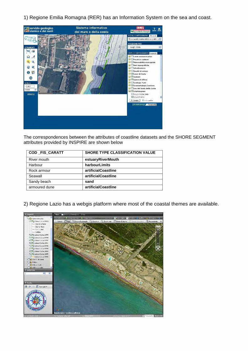
1) Regione Emilia Romagna (RER) has an Information System on the sea and coast.
The correspondences between the attributes of coastline datasets and the SHORE SEGMENT attributes provided by INSPIRE are shown below
COD _FIS_CARATT SHORE TYPE CLASSIFICATION VALUE
River mouth estuaryRiverMouth Harbour harbourLimits Rock armour artificialCoastline
Seawall artificialCoastline Sandy beach sand
armoured dune artificialCoastline
2) Regione Lazio has a webgis platform where most of the coastal themes are available.
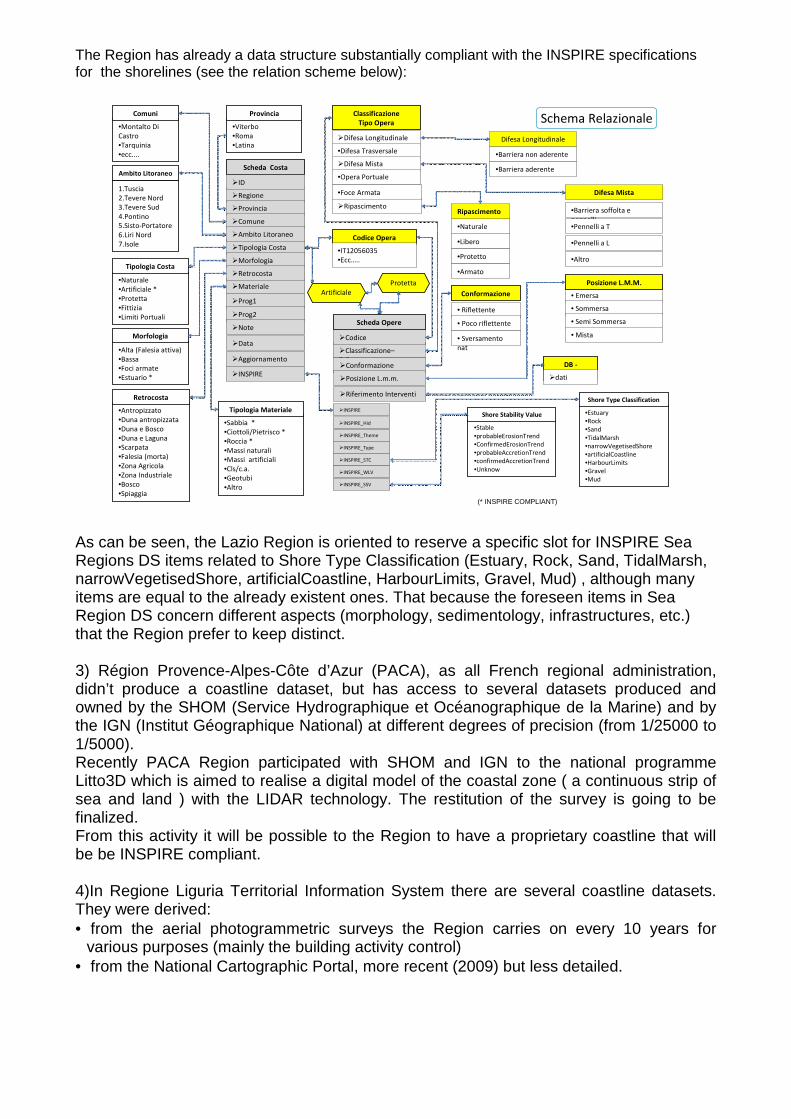
The Region has already a data structure substantially compliant with the INSPIRE specifications for the shorelines (see the relation scheme below):
•Montalto Di
Castro
•Tarquinia
•ecc....
Comuni
•Viterbo
•Roma
•Latina
Provincia
•Naturale
•Artificiale *
•Protetta
•Fittizia
•Limiti Portuali
Tipologia Costa
•Alta (Falesia attiva)
•Bassa
•Foci armate
•Estuario *
Morfologia
•Antropizzato
•Duna antropizzata
•Duna e Bosco
•Duna e Laguna
•Scarpata
•Falesia (morta)
•Zona Agricola
•Zona Industriale
•Bosco
•Spiaggia
Retrocosta
Scheda Opere
Scheda Costa
�Regione
�Provincia
�Comune
�Tipologia Costa
�Morfologia
�Materiale
�Classificazione–
T.Opera �Conformazione
�Posizione L.m.m.
�Prog1
�Difesa Longitudinale
•Difesa Trasversale
�Difesa Mista
•Opera Portuale
Classificazione
Tipo Opera
•Barriera non aderente
•Barriera soffolta e
pennelli
• Riflettente
• Poco riflettente
Conformazione • Emersa
• Sommersa
• Semi Sommersa
Posizione L.M.M.
Schema Relazionale
�Ripascimento
�Codice • Mista
�Retrocosta
•Sabbia *
•Ciottoli/Pietrisco *
•Roccia *
•Massi naturali
•Massi artificiali
•Cls/c.a.
•Geotubi
•Altro
Tipologia Materiale
�Riferimento Interventi
�Prog2
1.Tuscia
2.Tevere Nord
3.Tevere Sud
4.Pontino
5.Sisto-Portatore
6.Liri Nord
7.Isole
Ambito Litoraneo
�Ambito Litoraneo
DB -
Interventi�dati
Codice Opera
�ID
�Note
�Data
•Libero
•Protetto
•Armato
Protetta
• Sversamento
nat
•Naturale
•Foce Armata
•Barriera aderente
•Pennelli a T
•Pennelli a L
•Altro
Ripascimento
Difesa Mista
Difesa Longitudinale
�Aggiornamento
�INSPIRE
Artificiale
�INSPIRE_Hid
�INSPIRE_Theme
�INSPIRE_Type
�INSPIRE_STC
�INSPIRE_WLV
�INSPIRE
�INSPIRE_SSV
•IT12056035
•Ecc…..
•Estuary
•Rock
•Sand
•TidalMarsh
•narrowVegetisedShore
•artificialCoastline
•HarbourLimits
•Gravel
•Mud
Shore Type Classification
•Stable
•probableErosionTrend
•ConfirmedErosionTrend
•probableAccretionTrend
•confirmedAccretionTrend
•Unknow
Shore Stability Value
(* INSPIRE COMPLIANT)
As can be seen, the Lazio Region is oriented to reserve a specific slot for INSPIRE Sea Regions DS items related to Shore Type Classification (Estuary, Rock, Sand, TidalMarsh, narrowVegetisedShore, artificialCoastline, HarbourLimits, Gravel, Mud) , although many items are equal to the already existent ones. That because the foreseen items in Sea Region DS concern different aspects (morphology, sedimentology, infrastructures, etc.) that the Region prefer to keep distinct. 3) Région Provence-Alpes-Côte d’Azur (PACA), as all French regional administration, didn’t produce a coastline dataset, but has access to several datasets produced and owned by the SHOM (Service Hydrographique et Océanographique de la Marine) and by the IGN (Institut Géographique National) at different degrees of precision (from 1/25000 to 1/5000). Recently PACA Region participated with SHOM and IGN to the national programme Litto3D which is aimed to realise a digital model of the coastal zone ( a continuous strip of sea and land ) with the LIDAR technology. The restitution of the survey is going to be finalized. From this activity it will be possible to the Region to have a proprietary coastline that will be be INSPIRE compliant. 4)In Regione Liguria Territorial Information System there are several coastline datasets. They were derived: • from the aerial photogrammetric surveys the Region carries on every 10 years for
various purposes (mainly the building activity control) • from the National Cartographic Portal, more recent (2009) but less detailed.
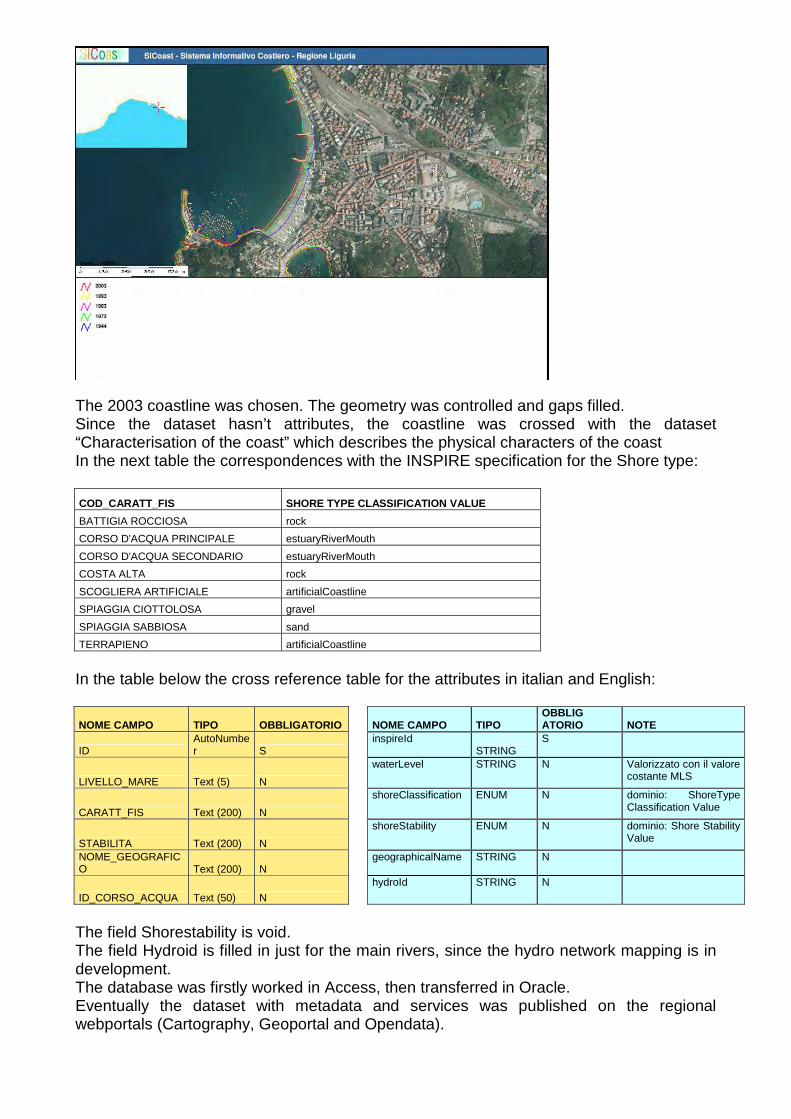
The 2003 coastline was chosen. The geometry was controlled and gaps filled. Since the dataset hasn’t attributes, the coastline was crossed with the dataset “Characterisation of the coast” which describes the physical characters of the coast In the next table the correspondences with the INSPIRE specification for the Shore type:
COD_CARATT_FIS SHORE TYPE CLASSIFICATION VALUE
BATTIGIA ROCCIOSA rock
CORSO D'ACQUA PRINCIPALE estuaryRiverMouth
CORSO D'ACQUA SECONDARIO estuaryRiverMouth
COSTA ALTA rock
SCOGLIERA ARTIFICIALE artificialCoastline
SPIAGGIA CIOTTOLOSA gravel
SPIAGGIA SABBIOSA sand
TERRAPIENO artificialCoastline
In the table below the cross reference table for the attributes in italian and English:
NOME CAMPO TIPO OBBLIGATORIO NOME CAMPO TIPO OBBLIGATORIO NOTE
ID AutoNumber S
inspireId STRING
S
LIVELLO_MARE Text (5) N
waterLevel STRING N Valorizzato con il valore costante MLS
CARATT_FIS Text (200) N
shoreClassification ENUM N dominio: ShoreType Classification Value
STABILITA Text (200) N
shoreStability ENUM N dominio: Shore Stability Value
NOME_GEOGRAFICO Text (200) N
geographicalName STRING N
ID_CORSO_ACQUA Text (50) N hydroId STRING N
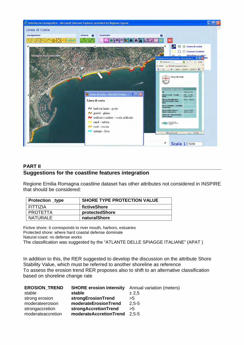
The field Shorestability is void. The field Hydroid is filled in just for the main rivers, since the hydro network mapping is in development. The database was firstly worked in Access, then transferred in Oracle. Eventually the dataset with metadata and services was published on the regional webportals (Cartography, Geoportal and Opendata).
PART II Suggestions for the coastline features integration Regione Emilia Romagna coastline dataset has other attributes not considered in INSPIRE that should be considered:
Protection _type SHORE TYPE PROTECTION VALUE FITTIZIA fictiveShore PROTETTA protectedShore NATURALE naturalShore
Fictive shore: it corresponds to river mouth, harbors, estuaries Protected shore: where hard coastal defense dominate Natural coast: no defense works The classification was suggested by the “ATLANTE DELLE SPIAGGE ITALIANE” (APAT ) In addition to this, the RER suggested to develop the discussion on the attribute Shore Stability Value, which must be referred to another shoreline as reference To assess the erosion trend RER proposes also to shift to an alternative classification based on shoreline change rate EROSION_TREND SHORE erosion intensity Annual variation (meters) stable stable ± 2,5 strong erosion strongErosionTrend >5 moderateerosion moderateErosionTrend 2,5-5 strongaccretion strongAccretionTrend >5 moderateaccretion moderateAccretionTrend 2,5-5
The method of analysis is based on the application of the Digital Shoreline Analysis System (DSAS) from USGS: • it computes rate-of-change statistics from multiple historic shoreline positions along
transects regularly spaced • It needs homogeneous mapping of shorelines • two or more shoreline are necessary for analysis In this way two more attributes are necessary, i.e. the year and the time interval of reference for the erosion analysis.
- 1 -
PROPOSAL
ON DATA AND CARTOGRAPHIC TOOLS (DT02.12)
Abstract The public data standardization and harmonisation process must follow the INSPIRE specifications. This document aims to deepen the knowledge of the state of the art of the specifications for the coastal themes in order to: - achieve the goal of a standardisation INSPIRE compliant of some datasets among the MAREMED partners;
- verify, from the point of view of the Mediterranean regional administrations, the utility of the attributes given to a typical coastal data, as the coastline;
- facing with a lack of involvement of the Mediterranean regions in the coastal issues at EU level, be recognized as entities that build a manage datasets in the same way as others more involved, as national hydrographical and marine mapping agencies.
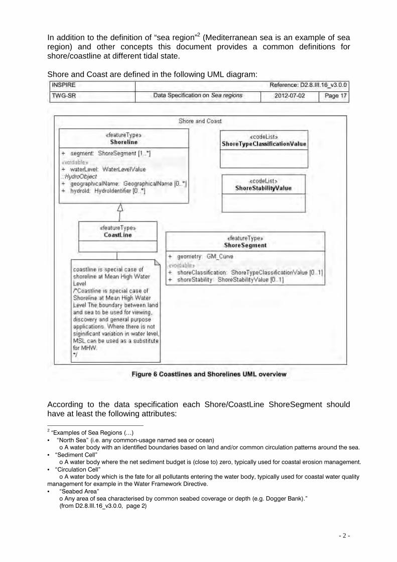
PART I INSPIRE and a typical coastal data: Shoreline and Coastline In the previous report on data and cartographic tools (DT01.12) we chose an information level interesting for the coastal management (coastline) as a pilot dataset to see which references there are at the level of data specification in INSPIRE References on the shore and coastline can be found in some INSPIRE data specifications as Elevation , Land cover (both in Annex II) and Hydrography (Annex I), but the document that reference more specific the argument is the INSPIRE “Sea regions” data specification1. So far the last document is “D2.8.III.16_v3.0.0 INSPIRE Data Specification on Sea regions – Draft Guidelines” dated 2012/07/02 and available on the INSPIRE website.
1 “The INSPIRE Sea Regions theme describes what most people would refer to as “the sea” and ”the coastline”. The Sea Regions model allows for the concept of named seas e.g. “Black Sea” and shorelines e.g. “Italian coastline at mean high water”. The model also provides a generic framework for describing subdivisions and aggregation of seas according to physical or chemical properties; for example, areas of sea according to their mean temperature, or areas with similar sediment characteristics. The Sea Regions theme also provides mechanisms to describe areas of sea bed or sea surface e.g. oil spills, or sea ice. Importantly, the Sea Regions theme also provides common definitions for the shore/coastline at different tidal states.” (from D2.8.III.16_v3.0.0, page VI)
- 2 -
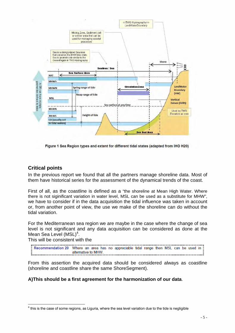
In addition to the definition of “sea region”2 (Mediterranean sea is an example of sea region) and other concepts this document provides a common definitions for shore/coastline at different tidal state. Shore and Coast are defined in the following UML diagram:
According to the data specification each Shore/CoastLine ShoreSegment should have at least the following attributes: 2 “Examples of Sea Regions (…)
• “North Sea” (i.e. any common-usage named sea or ocean) o A water body with an identified boundaries based on land and/or common circulation patterns around the sea.
• “Sediment Cell” o A water body where the net sediment budget is (close to) zero, typically used for coastal erosion management.
• “Circulation Cell” o A water body which is the fate for all pollutants entering the water body, typically used for coastal water quality
management for example in the Water Framework Directive.
• “Seabed Area” o Any area of sea characterised by common seabed coverage or depth (e.g. Dogger Bank).” (from D2.8.III.16_v3.0.0, page 2)
- 3 -
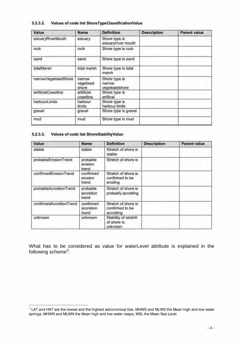
• geographicalName: at regional scale e.g. “Liguria Mean Sea Level” • hydroId: unique identifier • waterLevel: see below for the case of Mediterranean Sea Region • shoreTypeClassification: a value of 5.2.3.2 table • shoreStability: a value of 5.2.3.3 table
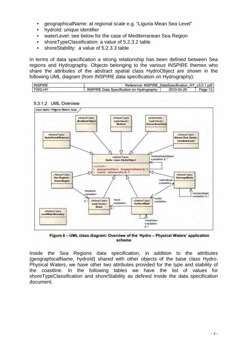
In terms of data specification a strong relationship has been defined between Sea regions and Hydrography. Objects belonging to the various INSPIRE themes who share the attributes of the abstract spatial class HydroObject are shown in the following UML diagram (from INSPIRE data specification on Hydrography):
Inside the Sea Regions data specification, in addition to the attributes (geographicalName, hydroId) shared with other objects of the base class Hydro- Physical Waters, we have other two attributes provided for the type and stability of the coastline. In the following tables we have the list of values for shoreTypeClassification and shoreStability as defined inside the data specification document.
- 4 -
What has to be considered as value for waterLevel attribute is explained in the following scheme3:
3 LAT and HAT are the lowest and the highest astronomical tide, MHWS and MLWS the Mean high and low water springs, MHWN and MLWN the Mean high and low water neaps, MSL the Mean Sea Level.
- 5 -
Critical points In the previous report we found that all the partners manage shoreline data. Most of them have historical series for the assessment of the dynamical trends of the coast. First of all, as the coastline is defined as a “the shoreline at Mean High Water. Where there is not siginificant variation in water level, MSL can be used as a substitute for MHW”, we have to consider if in the data acquisition the tidal influence was taken in account or, from another point of view, the use we make of the shoreline can do without the tidal variation. For the Mediterranean sea region we are maybe in the case where the change of sea level is not significant and any data acquisition can be considered as done at the Mean Sea Level (MSL)4. This will be consistent with the
From this assertion the acquired data should be considered always as coastline (shoreline and coastline share the same ShoreSegment). A)This should be a first agreement for the harmonization of our data .
4 this is the case of some regions, as Liguria, where the sea level variation due to the tide is negligible
- 6 -
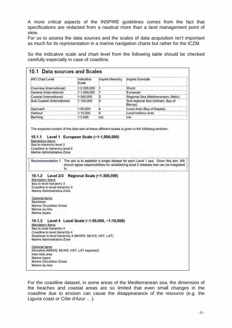
A more critical aspects of the INSPIRE guidelines comes from the fact that specifications are redacted from a nautical more than a land management point of view. For us to assess the data sources and the scales of data acquisition isn’t important as much for its representation in a marine navigation charts but rather for the ICZM. So the indicative scale and chart level from the following table should be checked carefully especially in case of coastline.
For the coastline dataset, in some areas of the Mediterranean sea, the dimension of the beaches and coastal areas are so limited that even small changes in the coastline due to erosion can cause the disappearance of the resource (e.g. the Liguria coast or Côte d'Azur .. .).
- 7 -
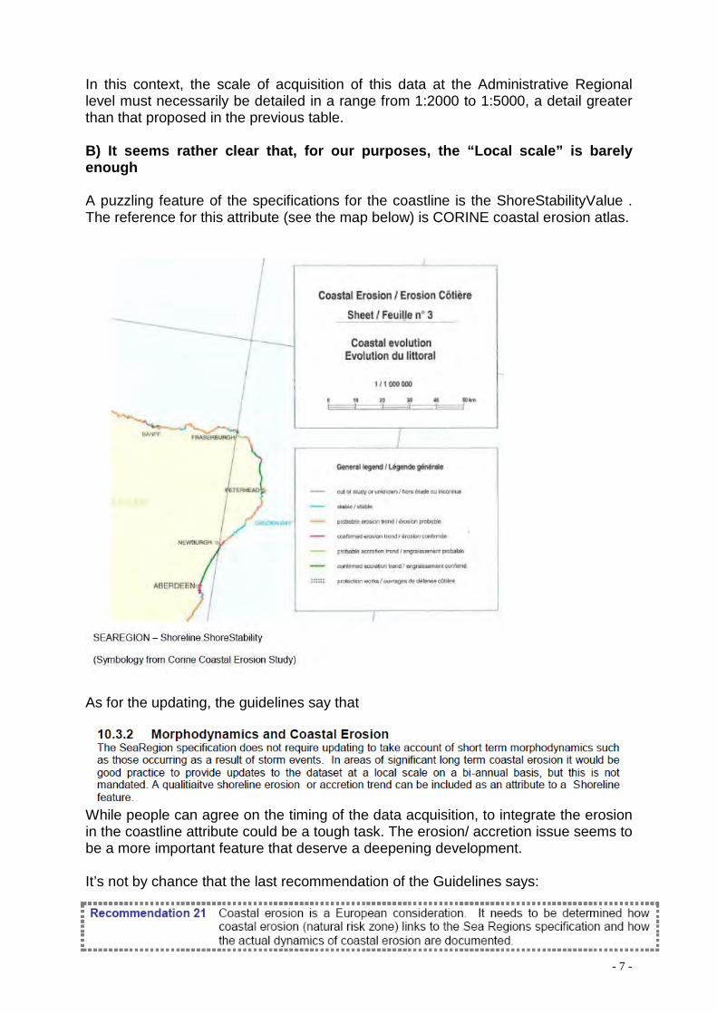
In this context, the scale of acquisition of this data at the Administrative Regional level must necessarily be detailed in a range from 1:2000 to 1:5000, a detail greater than that proposed in the previous table. B) It seems rather clear that, for our purposes, the “Local scale” is barely enough A puzzling feature of the specifications for the coastline is the ShoreStabilityValue . The reference for this attribute (see the map below) is CORINE coastal erosion atlas.
As for the updating, the guidelines say that
While people can agree on the timing of the data acquisition, to integrate the erosion in the coastline attribute could be a tough task. The erosion/ accretion issue seems to be a more important feature that deserve a deepening development. It’s not by chance that the last recommendation of the Guidelines says:
- 8 -
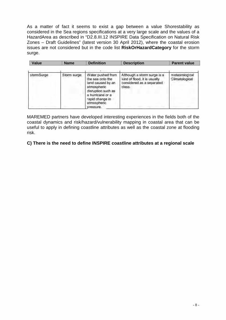
As a matter of fact it seems to exist a gap between a value Shorestability as considered in the Sea regions specifications at a very large scale and the values of a HazardArea as described in “D2.8.III.12 INSPIRE Data Specification on Natural Risk Zones – Draft Guidelines” (latest version 30 April 2012), where the coastal erosion issues are not considered but in the code list RiskOrHazardCategory for the storm surge.
Value Name Definition Description Parent value
MAREMED partners have developed interesting experiences in the fields both of the coastal dynamics and risk/hazard/vulnerability mapping in coastal area that can be useful to apply in defining coastline attributes as well as the coastal zone at flooding risk. C) There is the need to define INSPIRE coastline attributes at a regional scale
- 9 -
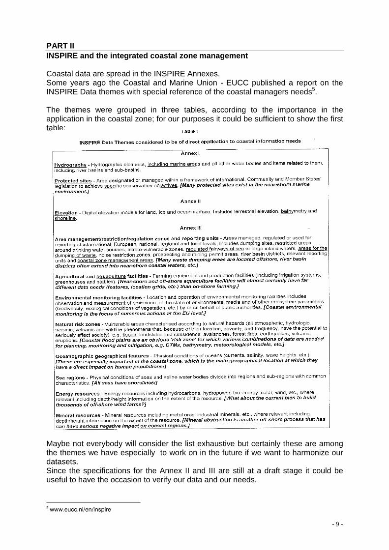
PART II INSPIRE and the integrated coastal zone management Coastal data are spread in the INSPIRE Annexes. Some years ago the Coastal and Marine Union - EUCC published a report on the INSPIRE Data themes with special reference of the coastal managers needs5. The themes were grouped in three tables, according to the importance in the application in the coastal zone; for our purposes it could be sufficient to show the first table: Maybe not everybody will consider the list exhaustive but certainly these are among the themes we have especially to work on in the future if we want to harmonize our datasets. Since the specifications for the Annex II and III are still at a draft stage it could be useful to have the occasion to verify our data and our needs.
5 www.eucc.nl/en/inspire
- 10 -
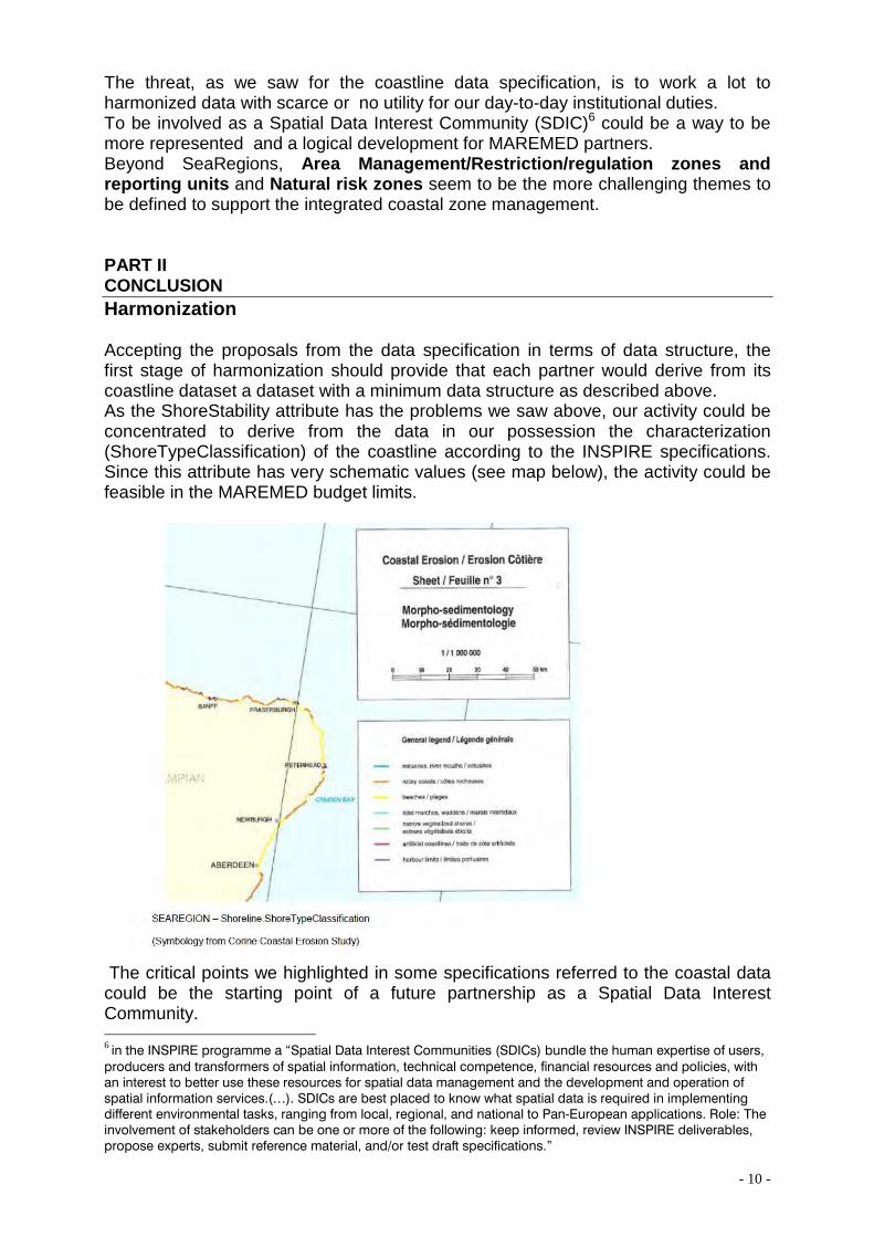
The threat, as we saw for the coastline data specification, is to work a lot to harmonized data with scarce or no utility for our day-to-day institutional duties. To be involved as a Spatial Data Interest Community (SDIC)6 could be a way to be more represented and a logical development for MAREMED partners. Beyond SeaRegions, Area Management/Restriction/regulation zones and reporting units and Natural risk zones seem to be the more challenging themes to be defined to support the integrated coastal zone management. PART II CONCLUSION Harmonization Accepting the proposals from the data specification in terms of data structure, the first stage of harmonization should provide that each partner would derive from its coastline dataset a dataset with a minimum data structure as described above. As the ShoreStability attribute has the problems we saw above, our activity could be concentrated to derive from the data in our possession the characterization (ShoreTypeClassification) of the coastline according to the INSPIRE specifications. Since this attribute has very schematic values (see map below), the activity could be feasible in the MAREMED budget limits.
The critical points we highlighted in some specifications referred to the coastal data could be the starting point of a future partnership as a Spatial Data Interest Community. 6 in the INSPIRE programme a “Spatial Data Interest Communities (SDICs) bundle the human expertise of users,
producers and transformers of spatial information, technical competence, financial resources and policies, with an interest to better use these resources for spatial data management and the development and operation of spatial information services.(…). SDICs are best placed to know what spatial data is required in implementing different environmental tasks, ranging from local, regional, and national to Pan-European applications. Role: The involvement of stakeholders can be one or more of the following: keep informed, review INSPIRE deliverables, propose experts, submit reference material, and/or test draft specifications.”