Embed Size (px)
Citation preview
Comprehensive Report of Phase 2 & 3 Research Results
MH21 Research Consortium
Ⅲ‐1
Ⅲ Resources Evaluation of the Methane Hydrate offshore Japan
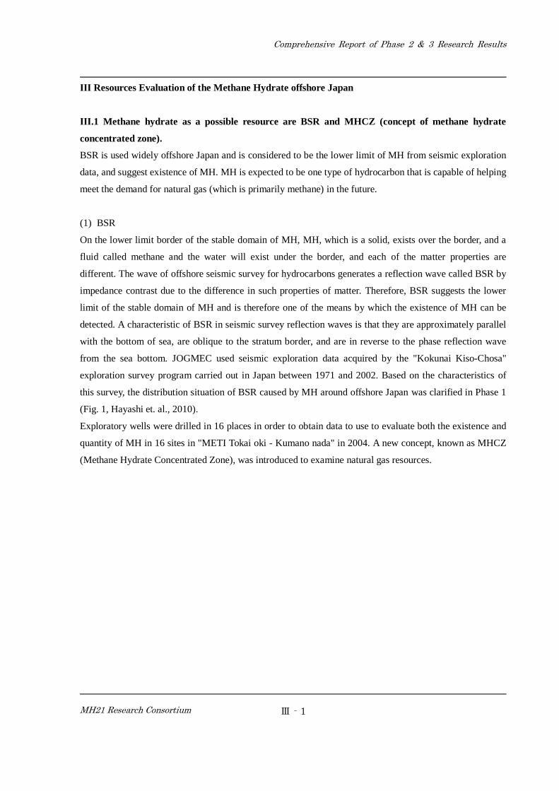
Ⅲ.1 Methane hydrate as a possible resource are BSR and MHCZ (concept of methane hydrate
concentrated zone).
BSR is used widely offshore Japan and is considered to be the lower limit of MH from seismic exploration
data, and suggest existence of MH. MH is expected to be one type of hydrocarbon that is capable of helping
meet the demand for natural gas (which is primarily methane) in the future.
(1) BSR
On the lower limit border of the stable domain of MH, MH, which is a solid, exists over the border, and a
fluid called methane and the water will exist under the border, and each of the matter properties are
different. The wave of offshore seismic survey for hydrocarbons generates a reflection wave called BSR by
impedance contrast due to the difference in such properties of matter. Therefore, BSR suggests the lower
limit of the stable domain of MH and is therefore one of the means by which the existence of MH can be
detected. A characteristic of BSR in seismic survey reflection waves is that they are approximately parallel
with the bottom of sea, are oblique to the stratum border, and are in reverse to the phase reflection wave
from the sea bottom. JOGMEC used seismic exploration data acquired by the "Kokunai Kiso-Chosa"
exploration survey program carried out in Japan between 1971 and 2002. Based on the characteristics of
this survey, the distribution situation of BSR caused by MH around offshore Japan was clarified in Phase 1
(Fig. 1, Hayashi et. al., 2010).
Exploratory wells were drilled in 16 places in order to obtain data to use to evaluate both the existence and
quantity of MH in 16 sites in "METI Tokai oki - Kumano nada" in 2004. A new concept, known as MHCZ
(Methane Hydrate Concentrated Zone), was introduced to examine natural gas resources.
Comprehensive Report of Phase 2 & 3 Research Results
MH21 Research Consortium
Ⅲ‐2
Fig. 1 BSR distribution chart (2009), (Hayashi et. al,2010)
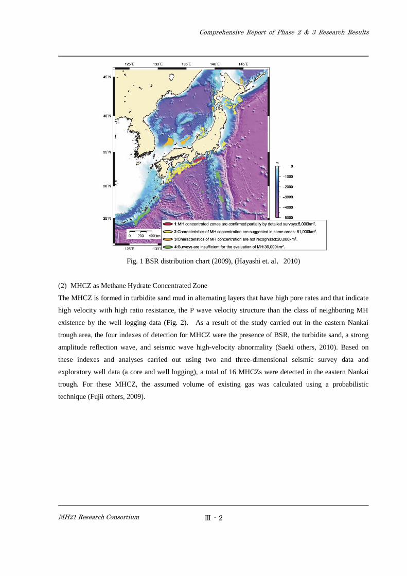
(2) MHCZ as Methane Hydrate Concentrated Zone
The MHCZ is formed in turbidite sand mud in alternating layers that have high pore rates and that indicate
high velocity with high ratio resistance, the P wave velocity structure than the class of neighboring MH
existence by the well logging data (Fig. 2). As a result of the study carried out in the eastern Nankai
trough area, the four indexes of detection for MHCZ were the presence of BSR, the turbidite sand, a strong
amplitude reflection wave, and seismic wave high-velocity abnormality (Saeki others, 2010). Based on
these indexes and analyses carried out using two and three-dimensional seismic survey data and
exploratory well data (a core and well logging), a total of 16 MHCZs were detected in the eastern Nankai
trough. For these MHCZ, the assumed volume of existing gas was calculated using a probabilistic
technique (Fujii others, 2009).
Comprehensive Report of Phase 2 & 3 Research Results
MH21 Research Consortium
Ⅲ‐3
Fig. 2 Characteristic of MHCZ (Saiki et. al, 2010)
A study of Phase 1 provided many results regarding the potential quantity of MH. However, regarding its
existence as well as properties and quantities of MHCZ in regions outside the eastern Nankai trough area,
there are many questions that need to be answered. It was also necessary to evaluate it using quantitative
techniques in MH systems such as the formation of, generation, migration, and accumulation of methane in
order to examine the causation that a MHCZ could be formed even if the existence of MH was suggested
via BSR.
Based on the above, the following two items were determined as research themes for Phase 2 and 3 of the
natural resources evaluation program to be carried out offshore Japan.
・Resources evaluation of the methane hydrate offshore Japan,
・Examination of the MH system.
References
[1] Tetsuya FUJII, Tatsuo SAEKI, Toshiaki KOBAYASHI, Takao INAMORI, Masao HAYASHI, Osamu
TAKANO, Tokujiro TAKAYAM, Sadao NAGAKUBO, Masaru NAKAMIZU and Kenichi
YOKOI(2010): Resource Assessment of Methane Hydrate by Applying a Probabilistic Approach in the
Eastern Nankai Trough, Japan
[2] Masao HAYASHI, Takao INAMORI, Tatsuo SAEKI and Satoshi NOGUCHI(2010): The distribution of
Comprehensive Report of Phase 2 & 3 Research Results
MH21 Research Consortium
Ⅲ‐4
BSRs related to methane hydrates, offshore Japan
[3] Tatsuo SAEKI, Tetsuya FUJII, Takao INAMORI, Tohiaki KOBAYASHI,Masao HAYASHI, Tatsuji
KAWASAKI, Sadao NAGAKUBO, Naoyuki SHIMODA, Satoshi NOGUCHI, Masaru NAKAMIZU,
Mizue NISHIMURA, Nobutaka OIKAWA and Tokujiro TAKAYAM(2010): Methane hydrate
exploration strategy and its progress
Ⅲ.2 Resources Evaluation of the Methane Hydrate Offshore Japan
For the purpose of achieving a deeper understanding of the availability of methane hydrate offshore Japan
in Phase 2 and 3, JOGMEC carried out an evaluation of MH using the interpretation technique based on the
index of the MHCZ and BSR provided for in Phase 1. The data sets used were old digitized 2D seismic
data, however, some reprocessed seismic data as well as new 2D/3D seismic data were also utilized. The
new 2D/3D seismic data were acquired as a result of using the "Shigen" seismic survey vessel, a vessel that
is used for the conventional hydrocarbon exploration program of Japan. In respect of the quantity of new
data that JOGMEC used for evaluation purposes, new 2D seismic data for approximately 18,000 km3 and
3D seismic data for 24,000km3 was acquired by the "Shigen". Additionally, after direct confirmation of the
existence of methane hydrate by well, we can call it with MHCZ.
Ⅲ.2.1 BSR Distribution
BSR is a reflection that extends obliquely from the geological bedding plane. It appears in reverse phase to
the reflection from the seafloor. An understanding of the BSR distribution area is also important as it serves
as an indicator as to whether MH is present on the upper level, and also provides insights into the planar
spread of MH.
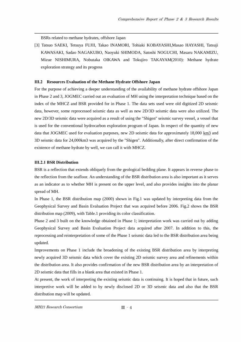
In Phase 1, the BSR distribution map (2000) shown in Fig.1 was updated by interpreting data from the
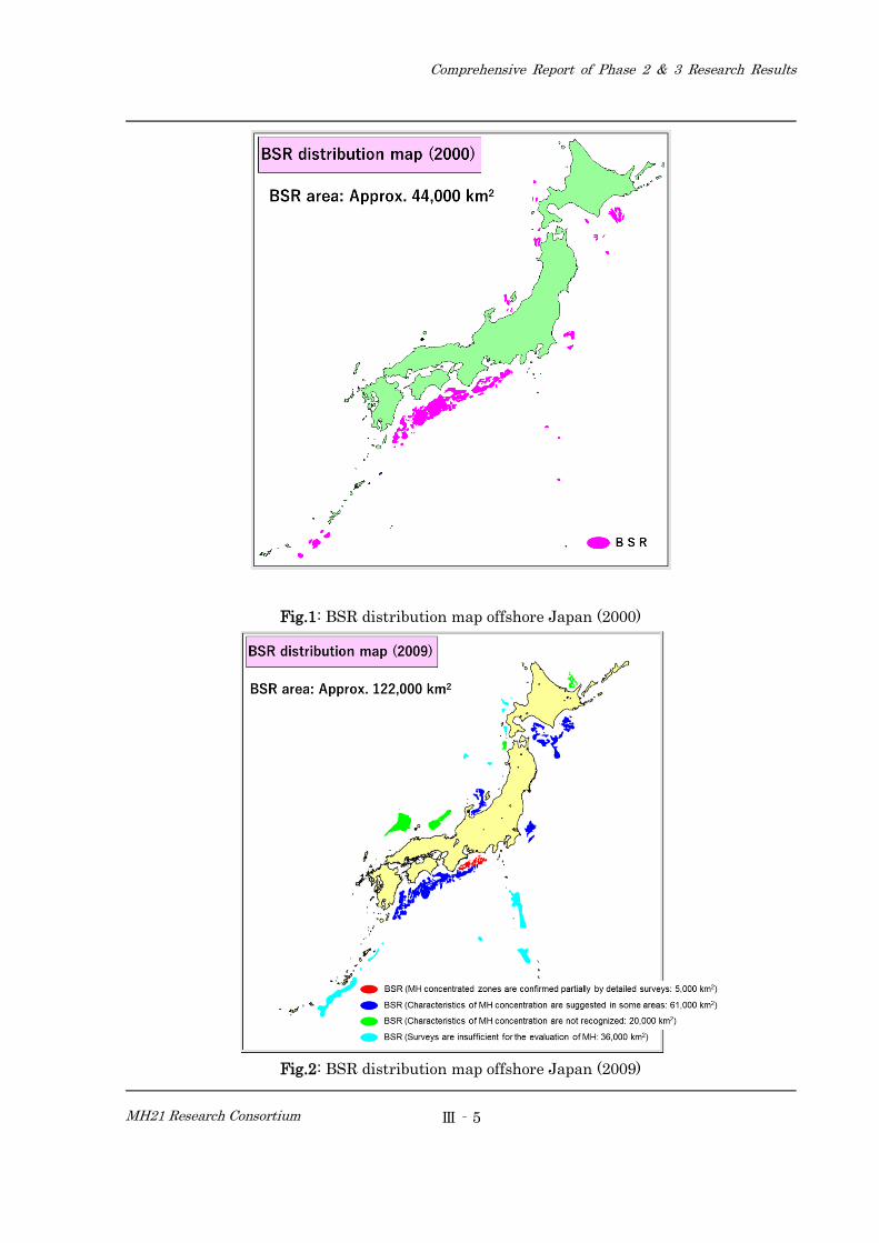
Geophysical Survey and Basin Evaluation Project that was acquired before 2006. Fig.2 shows the BSR
distribution map (2009), with Table.1 providing its color classification.
Phase 2 and 3 built on the knowledge obtained in Phase 1; interpretation work was carried out by adding
Geophysical Survey and Basin Evaluation Project data acquired after 2007. In addition to this, the
reprocessing and reinterpretation of some of the Phase 1 seismic data led to the BSR distribution area being
updated.
Improvements on Phase 1 include the broadening of the existing BSR distribution area by interpreting
newly acquired 3D seismic data which cover the existing 2D seismic survey area and refinements within
the distribution area. It also provides confirmation of the new BSR distribution area by an interpretation of
2D seismic data that fills in a blank area that existed in Phase 1.
At present, the work of interpreting the existing seismic data is continuing. It is hoped that in future, such
interpretive work will be added to by newly disclosed 2D or 3D seismic data and also that the BSR
distribution map will be updated.
Comprehensive Report of Phase 2 & 3 Research Results
MH21 Research Consortium
Ⅲ‐5
Fig.1: BSR distribution map offshore Japan (2000)
Fig.2: BSR distribution map offshore Japan (2009)
Comprehensive Report of Phase 2 & 3 Research Results
MH21 Research Consortium
Ⅲ‐6
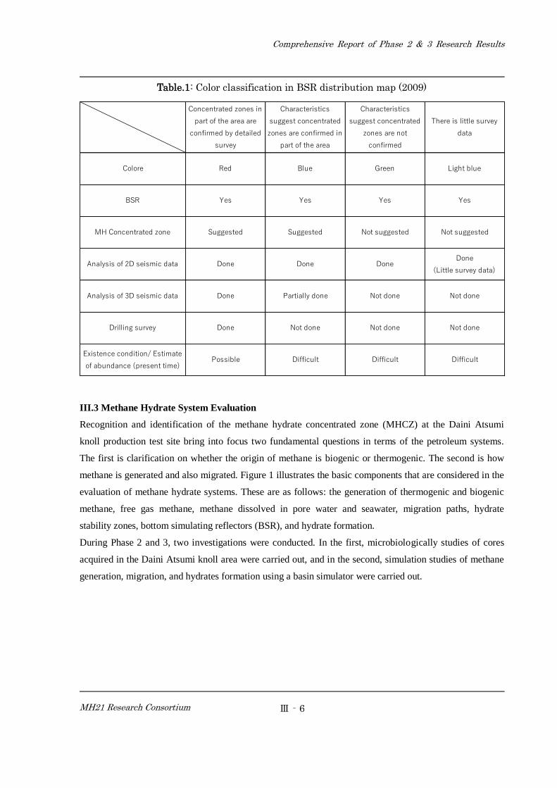
Table.1: Color classification in BSR distribution map (2009)
Concentrated zones in
part of the area are
confirmed by detailed
survey
Characteristics
suggest concentrated
zones are confirmed in
part of the area
Characteristics
suggest concentrated
zones are not
confirmed
There is little survey
data
Colore Red Blue Green Light blue
BSR Yes Yes Yes Yes
MH Concentrated zone Suggested Suggested Not suggested Not suggested
Analysis of 2D seismic data Done Done DoneDone
(Little survey data)
Analysis of 3D seismic data Done Partially done Not done Not done
Drilling survey Done Not done Not done Not done
Existence condition/ Estimate
of abundance (present time)Possible Difficult Difficult Difficult
III.3 Methane Hydrate System Evaluation
Recognition and identification of the methane hydrate concentrated zone (MHCZ) at the Daini Atsumi
knoll production test site bring into focus two fundamental questions in terms of the petroleum systems.
The first is clarification on whether the origin of methane is biogenic or thermogenic. The second is how
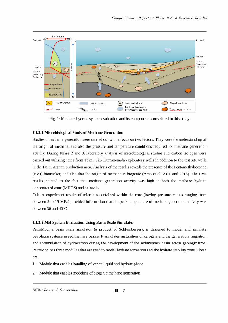
methane is generated and also migrated. Figure 1 illustrates the basic components that are considered in the
evaluation of methane hydrate systems. These are as follows: the generation of thermogenic and biogenic
methane, free gas methane, methane dissolved in pore water and seawater, migration paths, hydrate
stability zones, bottom simulating reflectors (BSR), and hydrate formation.
During Phase 2 and 3, two investigations were conducted. In the first, microbiologically studies of cores
acquired in the Daini Atsumi knoll area were carried out, and in the second, simulation studies of methane
generation, migration, and hydrates formation using a basin simulator were carried out.
Comprehensive Report of Phase 2 & 3 Research Results
MH21 Research Consortium
Ⅲ‐7
Fig. 1: Methane hydrate system evaluation and its components considered in this study
III.3.1 Microbiological Study of Methane Generation
Studies of methane generation were carried out with a focus on two factors. They were the understanding of
the origin of methane, and also the pressure and temperature conditions required for methane generation
activity. During Phase 2 and 3, laboratory analysis of microbiological studies and carbon isotopes were
carried out utilizing cores from Tokai Oki- Kumanonada exploratory wells in addition to the test site wells
in the Daini Atsumi production area. Analysis of the results reveals the presence of the Pentamethylicosane
(PMI) biomarker, and also that the origin of methane is biogenic (Amo et al. 2011 and 2016). The PMI
results pointed to the fact that methane generation activity was high in both the methane hydrate
concentrated zone (MHCZ) and below it.
Culture experiment results of microbes contained within the core (having pressure values ranging from
between 5 to 15 MPa) provided information that the peak temperature of methane generation activity was
between 30 and 40ºC.
III.3.2 MH System Evaluation Using Basin Scale Simulator
PetroMod, a basin scale simulator (a product of Schlumberger), is designed to model and simulate
petroleum systems in sedimentary basins. It simulates maturation of kerogen, and the generation, migration
and accumulation of hydrocarbon during the development of the sedimentary basin across geologic time.
PetroMod has three modules that are used to model hydrate formation and the hydrate stability zone. These
are
1. Module that enables handling of vapor, liquid and hydrate phase
2. Module that enables modeling of biogenic methane generation
Comprehensive Report of Phase 2 & 3 Research Results
MH21 Research Consortium
Ⅲ‐8
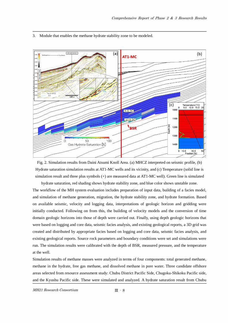
3. Module that enables the methane hydrate stability zone to be modeled.
Fig. 2. Simulation results from Daini Atsumi Knoll Area. (a) MHCZ interpreted on seismic profile, (b)
Hydrate saturation simulation results at AT1-MC wells and its vicinity, and (c) Temperature (solid line is
simulation result and three plus symbols (+) are measured data at AT1-MC well). Green line is simulated
hydrate saturation, red shading shows hydrate stability zone, and blue color shows unstable zone.
The workflow of the MH system evaluation includes preparation of input data, building of a facies model,
and simulation of methane generation, migration, the hydrate stability zone, and hydrate formation. Based
on available seismic, velocity and logging data, interpretations of geologic horizon and gridding were
initially conducted. Following on from this, the building of velocity models and the conversion of time
domain geologic horizons into those of depth were carried out. Finally, using depth geologic horizons that
were based on logging and core data, seismic facies analysis, and existing geological reports, a 3D grid was
created and distributed by appropriate facies based on logging and core data, seismic facies analysis, and
existing geological reports. Source rock parameters and boundary conditions were set and simulations were
run. The simulation results were calibrated with the depth of BSR, measured pressure, and the temperature
at the well.
Simulation results of methane masses were analyzed in terms of four components: total generated methane,
methane in the hydrate, free gas methane, and dissolved methane in pore water. Three candidate offshore
areas selected from resource assessment study: Chubu District Pacific Side, Chugoku-Shikoku Pacific side,
and the Kyushu Pacific side. These were simulated and analyzed. A hydrate saturation result from Chubu
Comprehensive Report of Phase 2 & 3 Research Results
MH21 Research Consortium
Ⅲ‐9
District Pacific side is illustrated in Figure (2). Simulated results reveal that methane generation has begun
at the epicenter of mini-basins and then migrated along the up dip direction until it began to accumulate in
lobe and channel-type turbiditic sandy deposits (Fujii et al. 2016).
III.3.3 Summary and Future Work
Biomarker and cultural experiments of microbes collected from the core were carried out. The results
suggest that the peak temperature for methane generation was between 30 and 40 ºC. Temperatures within
this range were applied in the simulation.
Evaluation of the MH system was carried out in order to better understand the mechanism of methane
generation, migration, and hydrate formation by using a basin scale simulator. Simulation studies within the
Daini Atsumi knoll area were conducted and calibrated by using measured pressures and temperatures at
AT1-MC. Simulated results of the distribution of MHCZ closely matched with the distribution of MHCZ
interpreted from the seismic profile. Using knowledge acquired from modeling and simulation results from
the Daini Atsumi knoll area, MH system evaluation of additional two offshore areas were conducted.
Although pressure and temperature values were lacking in terms of calibration, the depth of BSR and the
distribution pattern of the prospect on the seismic profile were used to calibrate the simulation results. In
future, conducting of mass analyses of the two areas are expected to be required.
References
[1] Miki Amo, Ryuko Izawa, Emiko Shinbo, Keiko Hatano and Tadaaki Shimada(2011). Vertical
Distribution of Biomarkers in Methane Hydrate Bearing Sediment Samples from the Eastern Nankai
Trough, Technology & Research Center Annual Report 2010-2011, 163-164.
[2] Miki Amo (2016). Study on Microbial Methane Production in Eastern Nankai
Trough Based on Geochemical and Microbiological Analyses, Technology & Research Center Annual
Report 2015-2016, 144.
[3] Fujii, T., Aung, T. T., Wada, N., Komatsu, Y., Suzuki, K., Ukita, T., & Egawa, K. (2016). Modeling gas
hydrate petroleum systems of the Pleistocene turbiditic sedimentary sequences of the Daini-Atsumi area,
eastern Nankai Trough, Japan. Interpretation, 4(1), SA95-SA111.
Ⅲ.4 Summary of Resources Evaluation of MH
During Phase 2 and 3 of the natural resources evaluation of methane hydrate offshore Japan, JOGMEC
carried out two programs. The first was "Resources evaluation of the methane hydrate offshore Japan", and
the second was "Methane Hydrate System Evaluation".
The initial program, "Resources evaluation of the methane hydrate offshore Japan", was conducted in order
Comprehensive Report of Phase 2 & 3 Research Results
MH21 Research Consortium
Ⅲ‐10
to evaluate whether or not the MHCZ sand type exists of offshore Japan. While making use of some of the
reprocessed seismic data, it also employed entirely new seismic data. The BSR map created from Phase 1
was revised. In addition, JOGMEC carried out an evaluation of the MHCZ offshore Japan in regions other
than the eastern Nankai trough area. In the other program, "Methane Hydrate System Evaluation,"
JOGMEC added two sea areas on the eastern Nankai trough and carried out methane Hydrate Basin
simulation in two and three dimensions.
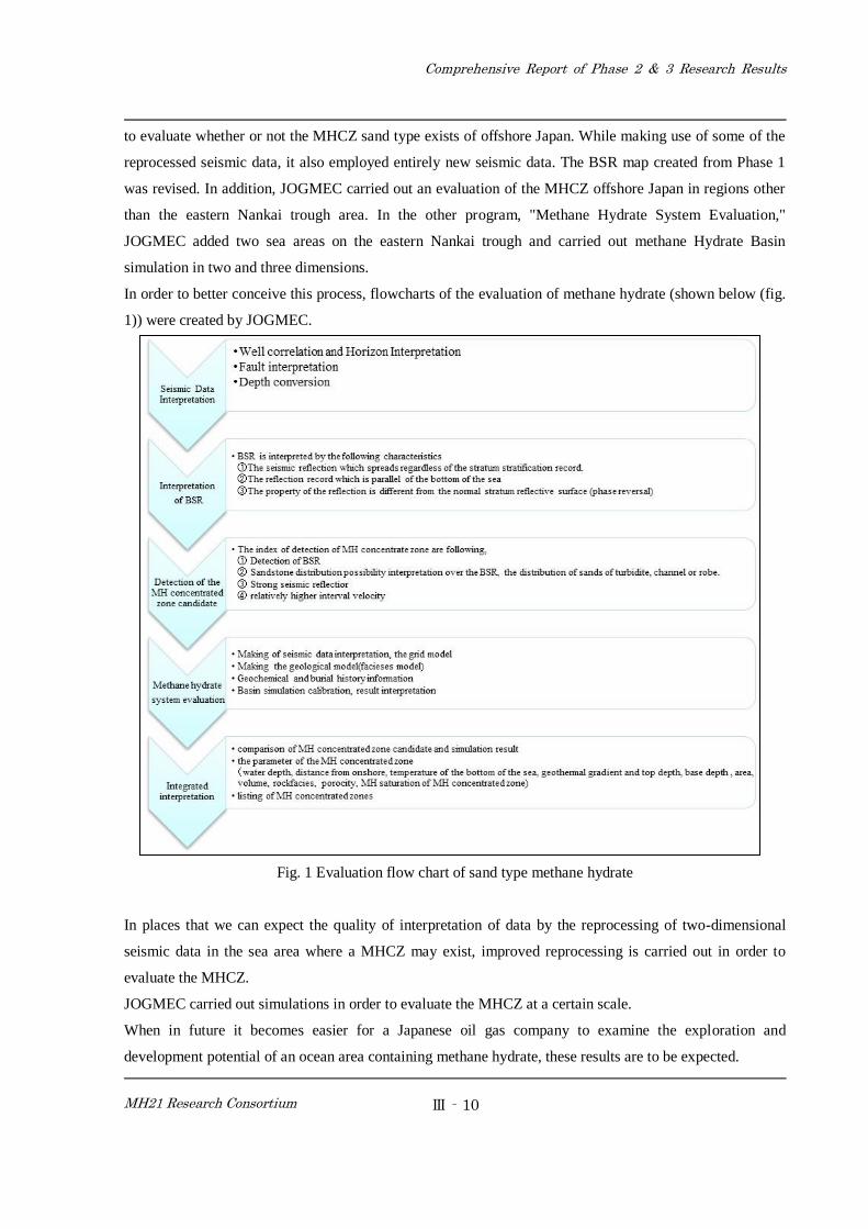
In order to better conceive this process, flowcharts of the evaluation of methane hydrate (shown below (fig.
1)) were created by JOGMEC.
Fig. 1 Evaluation flow chart of sand type methane hydrate
In places that we can expect the quality of interpretation of data by the reprocessing of two-dimensional
seismic data in the sea area where a MHCZ may exist, improved reprocessing is carried out in order to
evaluate the MHCZ.
JOGMEC carried out simulations in order to evaluate the MHCZ at a certain scale.
When in future it becomes easier for a Japanese oil gas company to examine the exploration and
development potential of an ocean area containing methane hydrate, these results are to be expected.
![Hydrate thermal dissociation behavior and dissociation enthalpies in methane … · mole basis, methane hydrate consists of 85.69(± 0.14)% water and 14.31(± 0.14)% methane [2]](https://img.pdfslide.net/doc/110x75/5fbd4df89eb682309316b186/hydrate-thermal-dissociation-behavior-and-dissociation-enthalpies-in-methane-mole.jpg)