Embed Size (px)
Citation preview
UTAH GEOLOGICAL SURVEY
�������������� ����������������������������
���������
���������������� ������������������
��� ���� ��������!"#�$%$ �&#!'�"�(���
��� ���)����)�������*�+
�� D GLYLVLRQ RI
� ������� ��� ���� �������������
7KLV RSHQ�ILOH UHOHDVH PDNHV LQIRUPDWLRQ DYDLODEOH WR WKH SXEOLF ZKLFK PD\ QRW FRQIRUP WR 8*6 SROLF\� HGLWRULDO� RUWHFKQLFDO VWDQGDUGV� 7KHUHIRUH LW PD\ EH SUHPDWXUH IRU DQ LQGLYLGXDO RU JURXS WR WDNH DFWLRQV EDVHG RQ LWV FRQWHQWV�
1
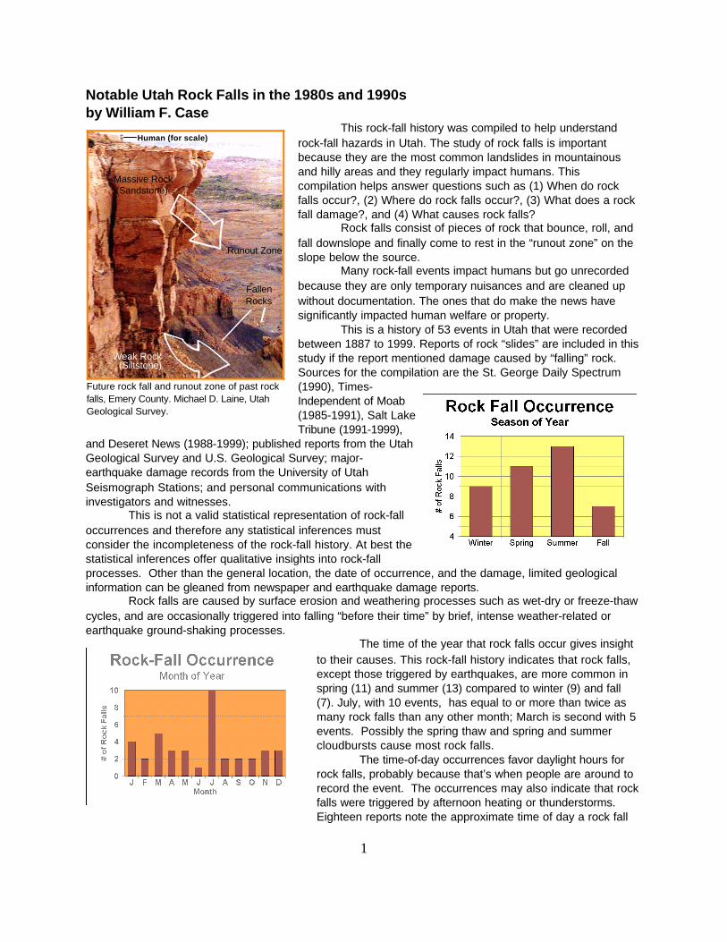
Human (for scale)
Future rock fall and runout zone of past rockfalls, Emery County. Michael D. Laine, UtahGeological Survey.
Notable Utah Rock Falls in the 1980s and 1990sby William F. Case
This rock-fall history was compiled to help understandrock-fall hazards in Utah. The study of rock falls is importantbecause they are the most common landslides in mountainousand hilly areas and they regularly impact humans. Thiscompilation helps answer questions such as (1) When do rockfalls occur?, (2) Where do rock falls occur?, (3) What does a rockfall damage?, and (4) What causes rock falls?
Rock falls consist of pieces of rock that bounce, roll, andfall downslope and finally come to rest in the “runout zone” on theslope below the source.
Many rock-fall events impact humans but go unrecordedbecause they are only temporary nuisances and are cleaned upwithout documentation. The ones that do make the news havesignificantly impacted human welfare or property.
This is a history of 53 events in Utah that were recordedbetween 1887 to 1999. Reports of rock “slides” are included in thisstudy if the report mentioned damage caused by “falling” rock. Sources for the compilation are the St. George Daily Spectrum(1990), Times-Independent of Moab(1985-1991), Salt LakeTribune (1991-1999),
and Deseret News (1988-1999); published reports from the UtahGeological Survey and U.S. Geological Survey; major-earthquake damage records from the University of UtahSeismograph Stations; and personal communications withinvestigators and witnesses.
This is not a valid statistical representation of rock-falloccurrences and therefore any statistical inferences mustconsider the incompleteness of the rock-fall history. At best thestatistical inferences offer qualitative insights into rock-fallprocesses. Other than the general location, the date of occurrence, and the damage, limited geologicalinformation can be gleaned from newspaper and earthquake damage reports.
Rock falls are caused by surface erosion and weathering processes such as wet-dry or freeze-thawcycles, and are occasionally triggered into falling “before their time” by brief, intense weather-related orearthquake ground-shaking processes.
The time of the year that rock falls occur gives insightto their causes. This rock-fall history indicates that rock falls,except those triggered by earthquakes, are more common inspring (11) and summer (13) compared to winter (9) and fall(7). July, with 10 events, has equal to or more than twice asmany rock falls than any other month; March is second with 5events. Possibly the spring thaw and spring and summercloudbursts cause most rock falls.
The time-of-day occurrences favor daylight hours forrock falls, probably because that’s when people are around torecord the event. The occurrences may also indicate that rockfalls were triggered by afternoon heating or thunderstorms. Eighteen reports note the approximate time of day a rock fall
Runout Zone
FallenRocks
Massive Rock(Sandstone)
Weak Rock(Siltstone)
2
Rock fall on the shoreline of Lake Powell.
Hikers near a large rock-fall clast.Rock slide on Bonneville Shoreline Trail.
occurred; 10 between 6 a.m. and 6 p.m, and 8 from 6 p.m. to 6 a.m. Fourteen reports of non-earthquake related rock falls suggest that the trigger was an intense
weather-related process, such as a rapid spring thaw or cloudburst; a triggering mechanism was notindicated in twenty-seven reports.
Most of the rock-fall damage, excluding those triggered by earthquakes, was to roads (19), railroadtracks (2), and water aqueducts (2); 8 reports of damage to homes and cars. Fourteen rock-fall eventsoccurred along trails and at outdoor-recreation sites, such as campgrounds. Between 1993 and 1999 rockfalls killed 4 people and injured 11.
Earthquake-triggered rock falls were not considered in the statistical inferences in this studybecause occurrence time is not relevant to other processes causing rock falls. Ground shaking, particularlyif the earthquake magnitude is greater than or equal to 5, produces widespread rock-fall damage to roads,canals, trails, and private property. Utah has had nine earthquakes of magnitude 5 or greater, and allproduced multiple rock falls (O’Brien and Nava, n.d.).
Rock Fall Reports, from 1999 to 1983October 10, 1999
A rock fall and slide occurred 7 miles up from the mouth of Big Cottonwood Canyon, Salt LakeCounty; four people were injured (Hinton, 1999).
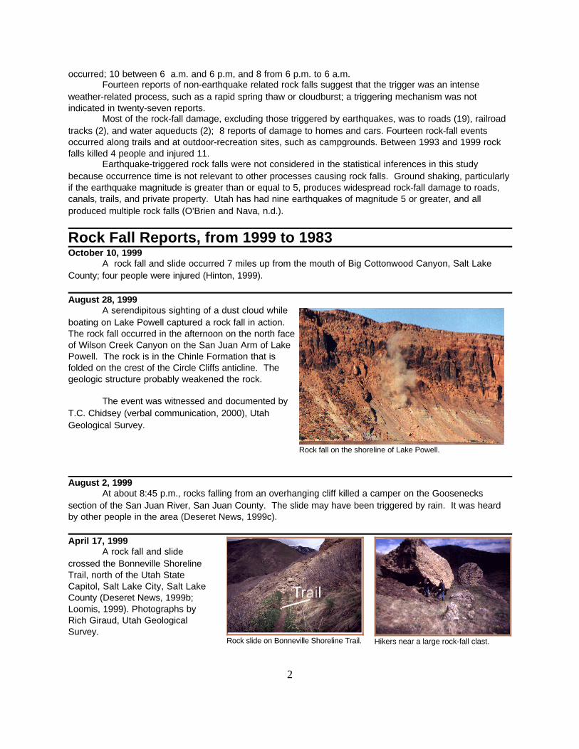
August 28, 1999A serendipitous sighting of a dust cloud while
boating on Lake Powell captured a rock fall in action. The rock fall occurred in the afternoon on the north faceof Wilson Creek Canyon on the San Juan Arm of LakePowell. The rock is in the Chinle Formation that isfolded on the crest of the Circle Cliffs anticline. Thegeologic structure probably weakened the rock.
The event was witnessed and documented byT.C. Chidsey (verbal communication, 2000), UtahGeological Survey.
August 2, 1999At about 8:45 p.m., rocks falling from an overhanging cliff killed a camper on the Goosenecks
section of the San Juan River, San Juan County. The slide may have been triggered by rain. It was heardby other people in the area (Deseret News, 1999c).
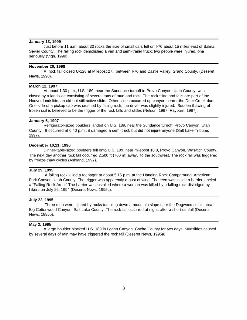
April 17, 1999A rock fall and slide
crossed the Bonneville ShorelineTrail, north of the Utah StateCapitol, Salt Lake City, Salt LakeCounty (Deseret News, 1999b;Loomis, 1999). Photographs byRich Giraud, Utah GeologicalSurvey.
3
January 13, 1999Just before 11 a.m. about 30 rocks the size of small cars fell on I-70 about 15 miles east of Salina,
Sevier County. The falling rock demolished a van and semi-trailer truck; two people were injured, oneseriously (Vigh, 1999).
November 20, 1998A rock fall closed U-128 at Milepost 27, between I-70 and Castle Valley, Grand County. (Deseret
News, 1998).
March 12, 1997At about 1:30 p.m., U.S. 189, near the Sundance turnoff in Provo Canyon, Utah County, was
closed by a landslide consisting of several tons of mud and rock. The rock slide and falls are part of theHoover landslide, an old but still active slide. Other slides occurred up canyon nearer the Deer Creek dam.One side of a pickup cab was crushed by falling rock; the driver was slightly injured. Sudden thawing offrozen soil is believed to be the trigger of the rock falls and slides (Nelson, 1997; Rayburn, 1997).
January 5, 1997Refrigerator-sized boulders landed on U.S. 189, near the Sundance turnoff, Provo Canyon, Utah
County. It occurred at 6:40 p.m.; it damaged a semi-truck but did not injure anyone (Salt Lake Tribune,1997).
December 10,11, 1996Dinner-table-sized boulders fell onto U.S. 189, near milepost 18.8, Provo Canyon, Wasatch County.
The next day another rock fall occurred 2,500 ft (760 m) away, to the southwest. The rock fall was triggeredby freeze-thaw cycles (Ashland, 1997).
July 29, 1995 A falling rock killed a teenager at about 5:15 p.m. at the Hanging Rock Campground, American
Fork Canyon, Utah County. The trigger was apparently a gust of wind. The teen was inside a barrier labeleda “Falling Rock Area.” The barrier was installed where a woman was killed by a falling rock dislodged byhikers on July 26, 1994 (Deseret News, 1995c).
July 22, 1995 Three men were injured by rocks tumbling down a mountain slope near the Dogwood picnic area,
Big Cottonwood Canyon, Salt Lake County. The rock fall occurred at night, after a short rainfall (DeseretNews, 1995b).
May 2, 1995A large boulder blocked U.S. 189 in Logan Canyon, Cache County for two days. Mudslides caused
by several days of rain may have triggered the rock fall (Deseret News, 1995a).
4
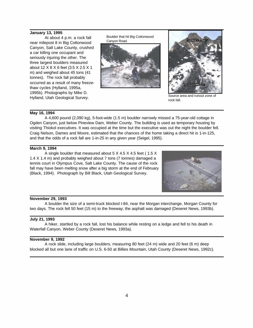
Source area and runout zone ofrock fall.
Boulder that hit Big CottonwoodCanyon Road.
January 13, 1995At about 4 p.m. a rock fall
near milepost 8 in Big CottonwoodCanyon, Salt Lake County, crusheda car killing one occupant andseriously injuring the other. Thethree largest boulders measuredabout 12 X 8 X 6 feet (3.5 X 2.5 X 1m) and weighed about 45 tons (41tonnes). The rock fall probablyoccurred as a result of many freeze-thaw cycles (Hylland, 1995a,1995b). Photographs by Mike D.Hylland, Utah Geological Survey.
May 16, 1994A 4,600 pound (2,090 kg), 5-foot-wide (1.5 m) boulder narrowly missed a 75-year-old cottage in
Ogden Canyon, just below Pineview Dam, Weber County. The building is used as temporary housing byvisiting Thiokol executives. It was occupied at the time but the executive was out the night the boulder fell.Craig Nelson, Dames and Moore, estimated that the chances of the home taking a direct hit is 1-in-125,and that the odds of a rock fall are 1-in-25 in any given year (Seigel, 1995).
March 9, 1994A single boulder that measured about 5 X 4.5 X 4.5 feet ( 1.5 X
1.4 X 1.4 m) and probably weighed about 7 tons (7 tonnes) damaged atennis court in Olympus Cove, Salt Lake County. The cause of the rockfall may have been melting snow after a big storm at the end of February(Black, 1994). Photograph by Bill Black, Utah Geological Survey.
November 29, 1993A boulder the size of a semi-truck blocked I-84, near the Morgan interchange, Morgan County for
two days. The rock fell 50 feet (15 m) to the freeway; the asphalt was damaged (Deseret News, 1993b).
July 21, 1993A hiker, startled by a rock fall, lost his balance while resting on a ledge and fell to his death in
Waterfall Canyon, Weber County (Deseret News, 1993a).
November 9, 1992A rock slide, including large boulders, measuring 80 feet (24 m) wide and 20 feet (6 m) deep
blocked all but one lane of traffic on U.S. 6-50 at Billies Mountain, Utah County (Deseret News, 1992c).
5
Rock fall into unused stretchof the Hurricane Canal.
Boulders on the Pah Tempe Resort trail.
Main House Guest House Mountain
Diagram showing boulder paths (Harty, 1991)
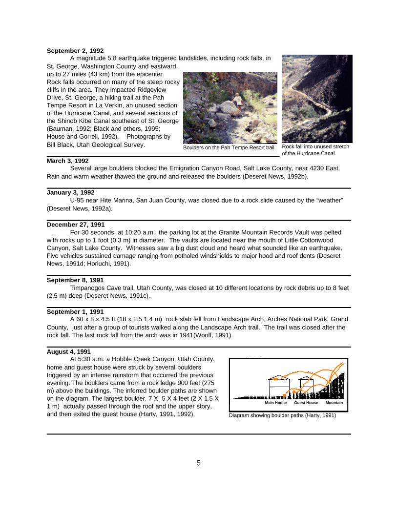
September 2, 1992A magnitude 5.8 earthquake triggered landslides, including rock falls, in
St. George, Washington County and eastward,up to 27 miles (43 km) from the epicenter.Rock falls occurred on many of the steep rockycliffs in the area. They impacted RidgeviewDrive, St. George, a hiking trail at the PahTempe Resort in La Verkin, an unused sectionof the Hurricane Canal, and several sections ofthe Shinob Kibe Canal southeast of St. George(Bauman, 1992; Black and others, 1995;House and Gorrell, 1992). Photographs byBill Black, Utah Geological Survey.
March 3, 1992Several large boulders blocked the Emigration Canyon Road, Salt Lake County, near 4230 East.
Rain and warm weather thawed the ground and released the boulders (Deseret News, 1992b).
January 3, 1992U-95 near Hite Marina, San Juan County, was closed due to a rock slide caused by the “weather”
(Deseret News, 1992a).
December 27, 1991For 30 seconds, at 10:20 a.m., the parking lot at the Granite Mountain Records Vault was pelted
with rocks up to 1 foot (0.3 m) in diameter. The vaults are located near the mouth of Little CottonwoodCanyon, Salt Lake County. Witnesses saw a big dust cloud and heard what sounded like an earthquake.Five vehicles sustained damage ranging from potholed windshields to major hood and roof dents (DeseretNews, 1991d; Horiuchi, 1991).
September 8, 1991Timpanogos Cave trail, Utah County, was closed at 10 different locations by rock debris up to 8 feet
(2.5 m) deep (Deseret News, 1991c).
September 1, 1991A 60 x 8 x 4.5 ft (18 x 2.5 1.4 m) rock slab fell from Landscape Arch, Arches National Park, Grand
County, just after a group of tourists walked along the Landscape Arch trail. The trail was closed after therock fall. The last rock fall from the arch was in 1941(Woolf, 1991).
August 4, 1991At 5:30 a.m. a Hobble Creek Canyon, Utah County,
home and guest house were struck by several boulderstriggered by an intense rainstorm that occurred the previousevening. The boulders came from a rock ledge 900 feet (275m) above the buildings. The inferred boulder paths are shownon the diagram. The largest boulder, 7 X 5 X 4 feet (2 X 1.5 X1 m) actually passed through the roof and the upper story,and then exited the guest house (Harty, 1991, 1992).
6
A big boulder broke through achain-link fence and came torest on older rock fall boulderused for lawn decor. Notehouse in background.
Rocks accumulated behind achain-link fence.
April 24, 1991An overnight rock slide blocked U-9 closing the stretch between Zion National Park and Mount
Carmel Junction, Kane County. Boulders were 10-15 feet (3-5 m) deep on the highway. The slide occurredat a road cut (Deseret News, 1991b).
February 16, 1991A small rock slide “... affected westbound traffic on I-80 and southbound traffic on I-215 ...” near the
mouth of Parleys Canyon, Salt Lake County. Rain triggered the rock fall at around 8 p.m. (Deseret News,1991a).
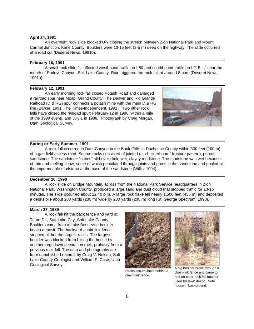
February 12, 1991An early morning rock fall closed Potash Road and damaged
a railroad spur near Moab, Grand County. The Denver and Rio GrandeRailroad (D & RG) spur connects a potash mine with the main D & RGline (Barker, 1991; The Times-Independent, 1991). Two other rockfalls have closed the railroad spur: February 12 in 1986 (within a mileof the 1999 event), and July 1 in 1988. Photograph by Craig Morgan,Utah Geological Survey.
Spring or Early Summer, 1991A rock fall occurred in Dark Canyon in the Book Cliffs in Duchesne County within 300 feet (100 m)
of a gas-field access road. Source rocks consisted of jointed (a “checkerboard” fracture pattern), poroussandstone. The sandstone “cubes” slid over slick, wet, clayey mudstone. The mudstone was wet becauseof rain and melting snow, some of which percolated through joints and pores in the sandstone and pooled atthe impermeable mudstone at the base of the sandstone (Willis, 1994).
December 20, 1990A rock slide on Bridge Mountain, across from the National Park Service headquarters in Zion
National Park, Washington County, produced a large sand and dust cloud that stopped traffic for 10-15minutes. The slide occurred about 12:40 p.m. A large rock flake fell nearly 1,500 feet (455 m) and depositeda debris pile about 200 yards (200 m) wide by 200 yards (200 m) long (St. George Spectrum, 1990).
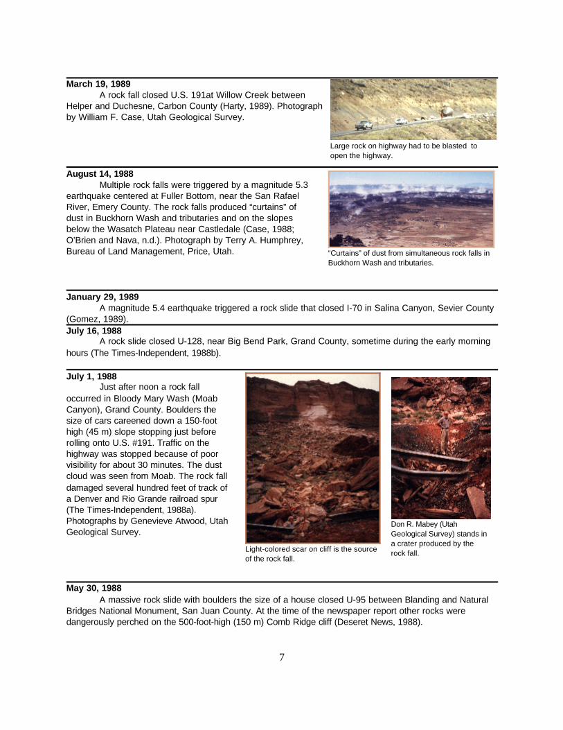
March 27, 1989A rock fall hit the back fence and yard at
Teton Dr., Salt Lake City, Salt Lake County.Boulders came from a Lake Bonneville boulder-beach deposit. The backyard chain-link fencestopped all but the largest rocks. The largestboulder was blocked from hitting the house byanother large lawn decoration rock, probably from aprevious rock fall. The data and photographs arefrom unpublished records by Craig V. Nelson, SaltLake County Geologist and William F. Case, UtahGeological Survey.
7
Don R. Mabey (UtahGeological Survey) stands ina crater produced by therock fall.
Large rock on highway had to be blasted toopen the highway.
“Curtains” of dust from simultaneous rock falls inBuckhorn Wash and tributaries.
Light-colored scar on cliff is the sourceof the rock fall.
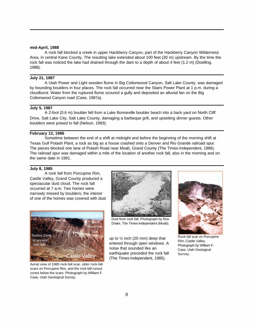
March 19, 1989A rock fall closed U.S. 191at Willow Creek between
Helper and Duchesne, Carbon County (Harty, 1989). Photographby William F. Case, Utah Geological Survey.
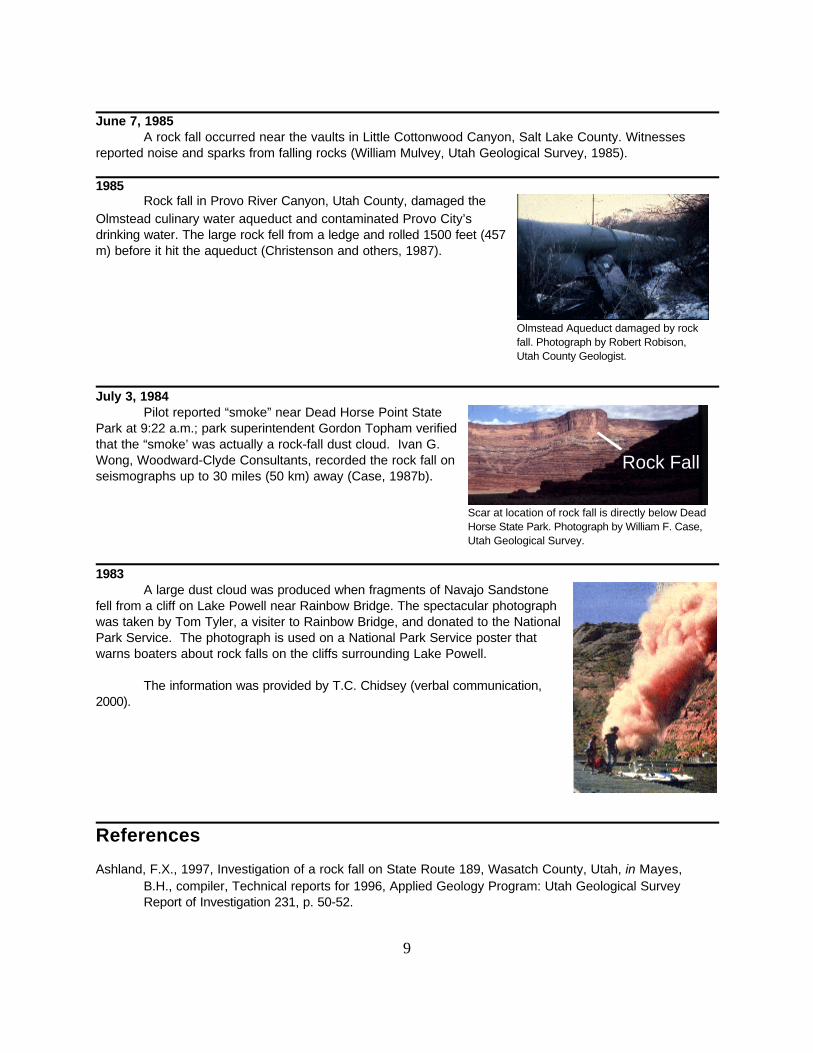
August 14, 1988Multiple rock falls were triggered by a magnitude 5.3
earthquake centered at Fuller Bottom, near the San RafaelRiver, Emery County. The rock falls produced “curtains” ofdust in Buckhorn Wash and tributaries and on the slopesbelow the Wasatch Plateau near Castledale (Case, 1988;O’Brien and Nava, n.d.). Photograph by Terry A. Humphrey,Bureau of Land Management, Price, Utah.
January 29, 1989A magnitude 5.4 earthquake triggered a rock slide that closed I-70 in Salina Canyon, Sevier County
(Gomez, 1989). July 16, 1988
A rock slide closed U-128, near Big Bend Park, Grand County, sometime during the early morninghours (The Times-Independent, 1988b).
July 1, 1988Just after noon a rock fall
occurred in Bloody Mary Wash (MoabCanyon), Grand County. Boulders thesize of cars careened down a 150-foothigh (45 m) slope stopping just beforerolling onto U.S. #191. Traffic on thehighway was stopped because of poorvisibility for about 30 minutes. The dustcloud was seen from Moab. The rock falldamaged several hundred feet of track ofa Denver and Rio Grande railroad spur(The Times-Independent, 1988a).Photographs by Genevieve Atwood, Utah Geological Survey.
May 30, 1988A massive rock slide with boulders the size of a house closed U-95 between Blanding and Natural
Bridges National Monument, San Juan County. At the time of the newspaper report other rocks weredangerously perched on the 500-foot-high (150 m) Comb Ridge cliff (Deseret News, 1988).
8
Aerial view of 1985 rock-fall scar, older rock-fallscars on Porcupine Rim, and the rock-fall runoutzones below the scars. Photograph by William F.Case, Utah Geological Survey.
Rock fall scar on PorcupineRim, Castle Valley.Photograph by William F.Case, Utah GeologicalSurvey.
Dust from rock fall. Photograph by RonDrake, The Times-Independent (Moab).
mid-April, 1988A rock fall blocked a creek in upper Hackberry Canyon, part of the Hackberry Canyon Wilderness
Area, in central Kane County. The resulting lake extended about 100 feet (30 m) upstream. By the time therock fall was noticed the lake had drained through the dam to a depth of about 4 feet (1.2 m) (Doelling,1988).
July 21, 1987A Utah Power and Light wooden flume in Big Cottonwood Canyon, Salt Lake County, was damaged
by bounding boulders in four places. The rock fall occurred near the Stairs Power Plant at 1 p.m. during acloudburst. Water from the ruptured flume scoured a gully and deposited an alluvial fan on the BigCottonwood Canyon road (Case, 1987a).
July 5, 1987A 2-foot (0.6 m) boulder fell from a Lake Bonneville boulder beach into a back yard on North Cliff
Drive, Salt Lake City, Salt Lake County, damaging a barbeque grill, and upsetting dinner guests. Otherboulders were poised to fall (Nelson, 1993).
February 12, 1986Sometime between the end of a shift at midnight and before the beginning of the morning shift at
Texas Gulf Potash Plant, a rock as big as a house crashed onto a Denver and Rio Grande railroad spur.The pieces blocked one lane of Potash Road near Moab, Grand County (The Times-Independent, 1986).The railroad spur was damaged within a mile of the location of another rock fall, also in the morning and onthe same date in 1991.
July 8, 1985A rock fall from Porcupine Rim,
Castle Valley, Grand County produced aspectacular dust cloud. The rock falloccurred at 7 a.m. Two homes werenarrowly missed by boulders; the interiorof one of the homes was covered with dust
up to ½ inch (20 mm) deep thatentered through open windows. Anoise that sounded like anearthquake preceded the rock fall(The Times-Independent, 1985).Castle Valley
Runout Zone
of ancientrock falls
1985Rock Fall
Scar
9
Scar at location of rock fall is directly below DeadHorse State Park. Photograph by William F. Case,Utah Geological Survey.
Olmstead Aqueduct damaged by rockfall. Photograph by Robert Robison,Utah County Geologist.
June 7, 1985A rock fall occurred near the vaults in Little Cottonwood Canyon, Salt Lake County. Witnesses
reported noise and sparks from falling rocks (William Mulvey, Utah Geological Survey, 1985).
1985Rock fall in Provo River Canyon, Utah County, damaged the
Olmstead culinary water aqueduct and contaminated Provo City’sdrinking water. The large rock fell from a ledge and rolled 1500 feet (457m) before it hit the aqueduct (Christenson and others, 1987).
July 3, 1984Pilot reported “smoke” near Dead Horse Point State
Park at 9:22 a.m.; park superintendent Gordon Topham verifiedthat the “smoke’ was actually a rock-fall dust cloud. Ivan G.Wong, Woodward-Clyde Consultants, recorded the rock fall onseismographs up to 30 miles (50 km) away (Case, 1987b).
1983A large dust cloud was produced when fragments of Navajo Sandstone
fell from a cliff on Lake Powell near Rainbow Bridge. The spectacular photographwas taken by Tom Tyler, a visiter to Rainbow Bridge, and donated to the NationalPark Service. The photograph is used on a National Park Service poster thatwarns boaters about rock falls on the cliffs surrounding Lake Powell.
The information was provided by T.C. Chidsey (verbal communication,2000).
References
Ashland, F.X., 1997, Investigation of a rock fall on State Route 189, Wasatch County, Utah, in Mayes,B.H., compiler, Technical reports for 1996, Applied Geology Program: Utah Geological SurveyReport of Investigation 231, p. 50-52.
Rock Fall
10
Barker, V.J., 1991, Rock slide across road will be blasted: Deseret News, February 14, 1991.Bauman, Joseph, 1992, Moderate quake causes damage in southern Utah: Deseret News, September 2,
1992.Black, B.D., 1994, Investigation of a rock fall in Olympus Cove, Salt Lake County, Utah, in Mayes, B.H.,
compiler, Technical reports for 1994-95, Applied Geology Program: Utah Geological Survey Reportof Investigation 228, p. 10-13.
Black, B.D., Mulvey, W.E., Lowe, Mike, and Solomon, B.J., 1995, Geologic effects, in Christenson, G.E.,editor, The September 2, 1992 ML 5.8 St. George earthquake, Washington County, Utah: UtahGeological Survey Circular 88, p. 2-11.
Case, W.F., 1987a, Big Cottonwood Canyon flume damaged by rock fall due to cloudburst: Utah GeologicalSurvey, Survey Notes, v. 21, no. 1, p. 9.
---1987b, Dead Horse Point rock fall recorded on seismograph: Utah Geological and Mineral Survey, SurveyNotes, v. 21, no 4, p. 5.
---1988, Geologic effects of the 14 and 18 August, 1988 earthquakes in Emery County, Utah: UtahGeological and Mineral Survey, Survey Notes, v. 22, no. 1, p. 8-14.
Christenson, G.E., Lowe, Mike, Nelson, C.V., Robinson, R.M., 1987, Geologic hazards and land-useplanning, Wasatch Front: Utah Geological and Mineral Survey, Survey Notes, v. 21, no. 1, p. 10.
Deseret News, 1962, Sharp quake rocks north Utah, 3 states jolted; Logan hard-hit: August 30, 1962.---1988, Rock fall closes U-95: May 30, 1988.---1991a, Power outage leaves basketball fans in dark: February 17, 1991.---1991b, Zion rock slide closes 15-mile stretch of U-9: April 25, 1991.---1991c, Timpanogos Cave reopens after rock slides are cleared: September 11, 1991.---1991d, Slide damages 5 vehicles: December 28, 1991.---1992a, San Juan road still closed: January 6, 1992.---1992b, Rocky road: March 3, 1992.---1992c, Rock and roll: November 10, 1992.---1993a, Weber teenager falls to death while hiking: Associated Press, July 22, 1993.---1993b, Crews to blast boulder blocking lane of I-84: November 30, 1993.---1995a, Huge boulder shuts down highway in Logan Canyon: May 3, 1995.---1995b, 3 men injured in hiking and climbing accidents: July 23, 1995.---1995c, Falling rock claims teen in American Fork Canyon stream: July 30, 1995.---1996, Provo River Canyon rock slide doesn’t stall traffic: December 10, 1996.---1998, Slide forces closure of stretch of U-128: November 20, 1998.---1999a, 2 injured and vehicles crushed as rocks fall on I-70 near Salina: January 18, 1999.---1999b, Geologist to study Salt Lake rock slide: Associated Press, June 1, 1999.---1999c, Camper killed in rock slide: August 2, 1999.Doelling, H.H., 1988, Rock fall in Hackberry Canyon, April, 1988: Utah Geological Survey, Survey Notes, v.
22, no. 1-2, p. 7.Gomez, Jess, 1989, Expect quake's aftershock this week, say experts: Salt Lake Tribune, January 31,
1989.Harty, K.M., 1989, Landslide mapping, hazards, and historical landslides in Utah: Utah Geological and
Mineral Survey, Survey Notes, v. 23, no. 4, p. 2-8.---1991, Rock fall damages residence in Hobble Creek Canyon, Utah County: Utah Geological Survey,
Survey Notes, v. 25, no. 1, p. 2.---1992, Investigation of a rock fall in Hobble Creek Canyon, Utah County, Utah, in Mayes, B.H., compiler,
Technical reports for 1990-1991 Applied Geology Program: Utah Geological Survey Report ofInvestigation 222, p. 178-180.
Hinton, Jay, 1999, 4 survive ride with Mother Nature: Deseret News, October 11, 1999.Horiuchi, Vince, 1991, Rockslide near LDS vaults damages cars: Salt Lake Tribune, December 28, 1991.House, Dawn, and Gorrell, Mike, 1992, Quake jars S. Utah, triggers massive slide, falling earth buries 3
homes, closes entrance to Zion Park: Salt Lake Tribune, September 3, 1992.
11
Hylland, M.D., 1995a, Fatal Big Cottonwood Canyon rock fall prompts UGS emergency response: UtahGeological Survey, Survey Notes, v. 27, no. 3, p. 13.
---1995b, Investigation of a rock fall in Big Cottonwood Canyon, Salt Lake County, Utah, in Mayes, B.H.,compiler, Technical reports for 1994-95, Applied Geology Program: Utah Geological Survey Reportof Investigation 228, p. 67-70.
Loomis, Brandon, 1999, Salt Lake City’s new geologic trail is shut down indefinitely, thanks to a very oldgeologic phenomenon: Salt Lake Tribune, May 29, 1999.
Nelson, C.V., 1993, Rock fall hazards - a guide for land-use planning, Salt Lake County, Utah, in Gori, P.L.,editor, Applications of research from the U.S. Geological Survey program Assessment of RegionalEarthquake Hazards and Risk along the Wasatch Front, Utah: U.S. Geological Survey ProfessionalPaper 1519, p. 141.
Nelson, Trent, 1997, Rock slide crushes truck, closes canyon: Salt Lake Tribune, March 13, 1997.Rayburn, Jim, 1997, Engineers rating stability of the area. Hillside fractures grow. Rockslide closes road in
Provo River Canyon: Deseret News, March 13, 1997.Salt Lake Tribune, 1997, Rock slide closes Provo River Canyon Road: January 5, 1997.Siegel, Lee, 1995, Hardheaded execs say rock-fall risk tolerable: Salt Lake Tribune, May 21, 1995.St. George Spectrum, 1990, Rock slide hinders visibility in Zion, phenomena probably caused by freezing,
thawing: St. George Spectrum, December 20, 1990.The Times-Independent, 1985, Massive rock slide ...: The Times-Independent, July 11, 1985.---1986, Rock as big as a house ...:The Times-Independent, February 13, 1986.---1988a, Tracks out of commission ...: The Times-Independent, July 7, 1988. ---1988b, A bad year for rock slides ...: The Times-Independent, July 21, 1988.---1991, That’s a lot of rock ...: The Times-Independent, February 14, 1991. Vigh, Michael, 1999, Slide hurts 2 motorists, closes interstate; “Those rocks were huge, they were
monsters,'' says injured semi driver: Salt Lake Tribune, January 14, 1999.Willis, G.C., 1994, Anatomy of a rock fall: Utah Geological Survey, Survey Notes, v. 26, no. 2-3, p. 11-13.Woolf, Jim, 1991, Mother Nature giveth and taketh away: Salt Lake Tribune, September 8, 1991.


![Moselele Book6 Extraction · [Em][G*]!Iwannarock![Am*]!(ROCK)!rock![Am*]!(ROCK)!rock![Am]!(ROCK)! [Em][G*]!Iwannarock![Am*]!(ROCK)!rock![Am*]!(ROCK)!rock![Am]!(ROCK)! I[Em]!want[C*]!to!rock