Embed Size (px)
Citation preview
Prepared in cooperation with the Michigan Geological Survey and the Great Lakes Geologic Mapping Coalition
Surficial Geologic Map of Berrien County, Michigan, and the Adjacent Offshore Area of Lake Michigan
By Byron D. Stone, Kevin A. Kincare, Dennis W. O’Leary, Wayne L. Newell, Emily M. Taylor, Van S. Williams, Scott C. Lundstrom, Jared E. Abraham, and Michael H. Powers
Pamphlet to accompanyScientific Investigations Map 3383
U.S. Department of the InteriorU.S. Geological Survey
U.S. Department of the InteriorRYAN K. ZINKE, Secretary
U.S. Geological SurveyWilliam H. Werkheiser, Deputy Director exercising the authority of the Director
U.S. Geological Survey, Reston, Virginia: 2017
For more information on the USGS—the Federal source for science about the Earth, its natural and living resources, natural hazards, and the environment—visit http://www.usgs.gov or call 1–888–ASK–USGS.
For an overview of USGS information products, including maps, imagery, and publications, visit http://store.usgs.gov.
Any use of trade, firm, or product names is for descriptive purposes only and does not imply endorsement by the U.S. Government.
Although this information product, for the most part, is in the public domain, it also may contain copyrighted materials as noted in the text. Permission to reproduce copyrighted items must be secured from the copyright owner.
Suggested citation:Stone, B.D., Kincare, K.A., O’Leary, D.W., Newell, W.L., Taylor, E.M., Williams, V.S., Lundstrom, S.C., Abraham, J.E., and Powers, M.H., 2017, Surficial geologic map of Berrien County, Michigan, and the adjacent offshore area of Lake Michigan: U.S. Geological Survey Scientific Investigations Map 3383, 2 sheets, scale 1:50,000, and 49-p. pamphlet, https://doi.org/10.3133/sim3383.
ISSN 2329-1311 (print) ISSN 2329-132X (online)ISBN 978-1-4113-4154-8
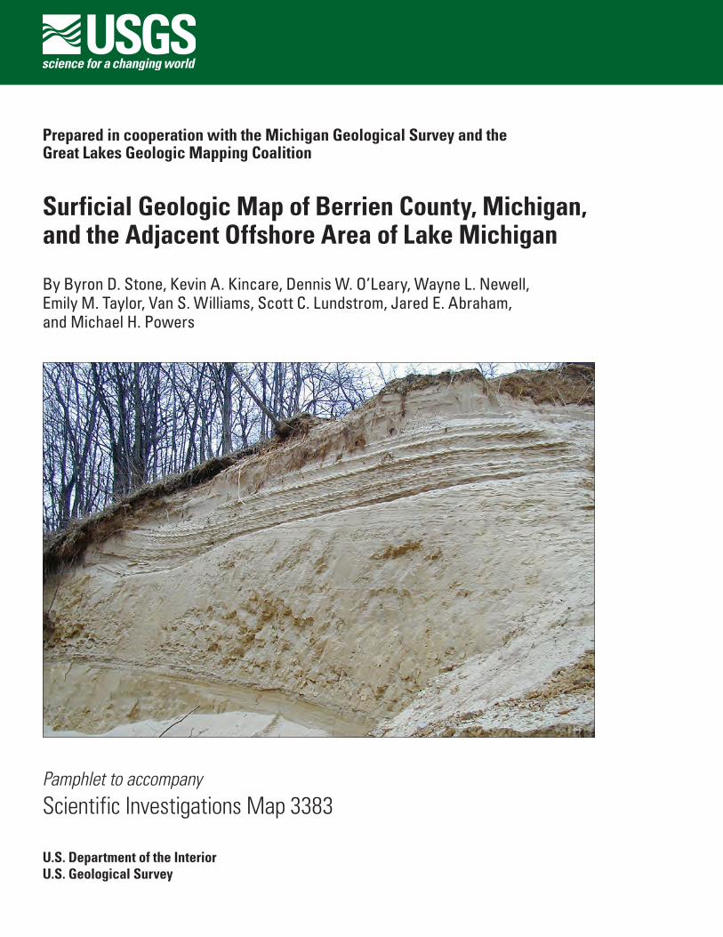
Cover. Outcrop of glacial deposits in central Berrien County, Michigan, northwest of Berrien Springs. Glacial meltwater terrace cobble gravel (map unit Qcgj; brown sediment in upper right corner of image) overlies complex sandy deposits of the Oronoko ice marginal delta (map unit Qdo) in the north wall of a gravel pit on the edge of the St. Joseph River flood plain. Crossbeds in the gravel show that this glacial river flowed northward down the ancestral St. Joseph River valley. The delta foreset sand beds having climbing-ripple bedforms dip to the left, indicating southwestward flow of lake currents at the front of the delta. Altitude of the top of the 10-meter (m)-thick deltaic section is 195 m, which was at 29 m depth in glacial Lake Dowagiac.
iii
Contents
Introduction.....................................................................................................................................................1Location and Features of Berrien County .........................................................................................1Scope of the Present Study and Geologic Map ..............................................................................1
Previous Geologic Studies and Maps of the Berrien County Region ...................................................3Bedrock Geology...................................................................................................................................3Late Mesozoic to Tertiary Erosion ......................................................................................................4Glacial Geology .....................................................................................................................................4
Bedrock Surface Topography ......................................................................................................................5Thickness of Glacial and Postglacial Deposits .........................................................................................6Lithostratigraphy of Berrien County ...........................................................................................................6
Bedrock Lithostratigraphy ...................................................................................................................6Lithostratigraphy of Surficial Deposits ..............................................................................................8
Glacial Stratigraphy of Berrien County ......................................................................................................9Quaternary Morainic Systems ............................................................................................................9Deposits of Glacial Lakes in Stratified-Drift Moraines in Berrien County ...................................9
Morphology and Sedimentary Characteristics of Glacial-Lake Deposits ..........................9Lakes of the Kalamazoo and Valparaiso Morainic Systems ...............................................10Glacial Lake Madron in the Valparaiso Morainic System ...................................................10Glacial Lake Dowagiac in the Valparaiso Morainic system ...............................................12Glacial Lake Baroda in the Lake Border Morainic System .................................................12Glacial Lake Chicago .................................................................................................................13Glacial Lake Algonquin .............................................................................................................13
Till and Moraine Ridge Deposits in Berrien County ......................................................................14Morphology and Sedimentary Characteristics of Till-Ridge Moraines ............................14Valparaiso Morainic System ....................................................................................................14Lake Border Morainic System .................................................................................................15
Deposits of Postglacial Lakes and Streams in Berrien County ............................................................15Chippewa and Nipissing Lake Phases ............................................................................................15Postglacial Stream, Swamp, Eolian, and Colluvium Deposits .....................................................16Lake Michigan Deposits ....................................................................................................................16
Late Quaternary Geologic History of Berrien County ............................................................................16Multiple Glacial Episodes and Glacial Erosion ..............................................................................16Lake Michigan Ice Lobe Glaciation During the Late Pleistocene Michigan Subepisode ......17Postglacial Erosion and Deposition of the Hudson Episode ........................................................20
References Cited..........................................................................................................................................21Description of Surface and Subsurface Map Units ...............................................................................27
Quaternary ...........................................................................................................................................27Holocene .....................................................................................................................................27Holocene and Late Wisconsinan ............................................................................................28Late Wisconsinan ......................................................................................................................28Late Wisconsinan Glacial Meltwater Deposits ....................................................................29
Deposits of Glacial Streams ............................................................................................29Deposits of Glacial Lakes ................................................................................................30
iv
Deposits of Glacial Lake Baroda of the Lake Border Morainic System .........31Ice-Marginal Deltaic Deposits of the Valparaiso Morainic System ................32Deposits of Glacial Lake Dowagiac of the Valparaiso Morainic System .......32Deposits of Glacial Lake Madron of the Valparaiso Morainic System ...........34Ice-Marginal Deltaic Deposits of the Kalamazoo Morainic System ...............35
Late Wisconsinan Till and Moraine Ridge Deposits ............................................................35Clayey-Silt Till Deposits of the Lake Border Morainic System ..................................36Clayey-Silt Till Deposits of the Valparaiso Morainic System ....................................36Clayey-Silt Till Deposits of the Lower Kalamazoo Morainic System ........................37
Description of Bedrock Map Units ...........................................................................................................37Mississippian .......................................................................................................................................37Devonian...............................................................................................................................................38
Appendix 1. Description of Stratigraphic Drill-Hole Logs .................................................................39
Figures
1. Grain-size classification of sedimentary particles, meltwater deposits, and till ...............22. Ternary diagram showing grain-size classification of matrix of sandy, silty, and
clayey tills, based on U.S. Department of Agriculture soil texture classification ..............33. Generalized cross section showing sedimentary facies and collapse structures
in a glaciodeltaic morphosequence ........................................................................................11
Table
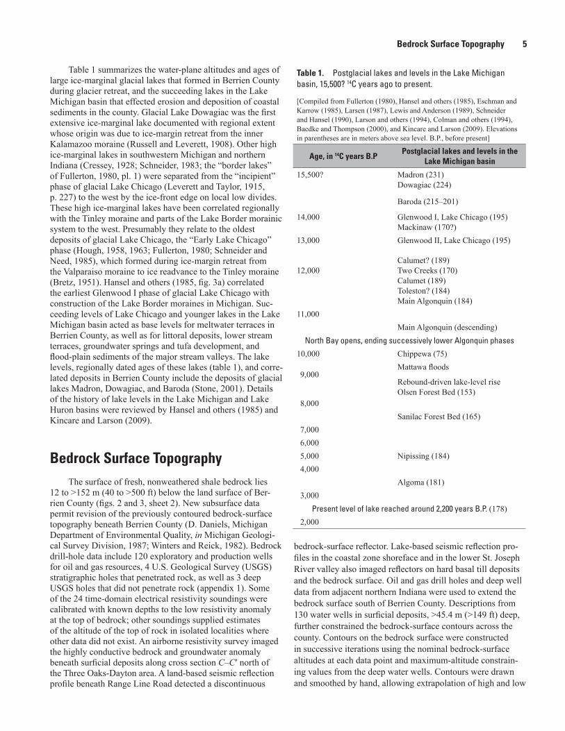
1. Postglacial lakes and levels in the Lake Michigan basin, 15,500? 14C years agoto present .......................................................................................................................................5
Conversion Factors and Datums
International System of Units to U.S. Customary units
Multiply By To obtain
Length
centimeter (cm) 0.3937 inch (in.)millimeter (mm) 0.03937 inch (in.)meter (m) 3.281 foot (ft) kilometer (km) 0.6214 mile (mi)
Area
square kilometer (km2) 0.3861 square mile (mi2)
Vertical coordinate information is referenced to the National Geodetic Vertical Datum of 1929 (NGVD 29). Horizontal coordinate information is referenced to the North American Datum of 1927 (NAD 27).
Surficial Geologic Map of Berrien County, Michigan, and the Adjacent Offshore Area of Lake Michigan
By Byron D. Stone, Kevin A. Kincare, Dennis W. O’Leary, Wayne L. Newell, Emily M. Taylor, Van S. Williams, Scott C. Lundstrom, Jared E. Abraham, and Michael H. Powers
IntroductionThe surficial geologic map of Berrien County, Michigan
(sheet 1) shows the distribution of glacial and postglacial deposits at the land surface of the county and at the lake floor in the adjacent offshore area of Lake Michigan. Cross sections (sheet 1) and a series of surface/subsurface map illustrations (sheet 2) show the subsurface extension of these deposits down to the buried bedrock surface beneath the county and the lake. The geologic map differentiates surficial materials of Quaternary age on the basis of their lithologic character-istics, stratigraphic relationships, and age, as shown in the Correlation of Surface and Subsurface Map Units (sheet 1) and detailed in the Description of Surface and Subsurface Map Units and the Description of Bedrock Map Units. Drill-hole information documents typical stratigraphic sequences (appendix 1) that compose one or more penetrated geologic map units. A reference map (fig. 1, sheet 2) shows the loca-tion of the morainic systems in Berrien County. A map of total thickness of surficial deposits (fig. 2, sheet 2) shows the distri-bution of as much as 150 meters (m) (492 feet (ft)) of surficial materials that overlie the bedrock surface. The topography of the buried bedrock surface (fig. 3, sheet 2) is the base map for a new, provisional bedrock geologic map of Berrien County (also fig. 3, sheet 2), which is derived from subsurface drill-hole information. The geologic map, subsurface map figures, subsurface drill-hole data, and subsurface geophysical surveys (Campbell, 2001; Duval and others, 2002) portray the surface and three-dimensional details of the geology of Berrien County.
Location and Features of Berrien County
Berrien County occupies an area of 1,479 square kilometers (km2) (571 square miles (mi2)) in the southwestern corner of Michigan (map, sheet 1), adjacent to Lake Michigan to the west, La Porte and St. Joseph Counties, Indiana, to the south, Cass County, Mich., to the east, and Van Buren County, Mich., to the north and northeast. The major physical features of the county are related principally to deposits of the last Laurentide
ice sheet that advanced and then retreated back through the region from about 19,000 to 14,000 radiocarbon (14C) years before present (B.P.) (hereinafter also referred to as radiocar-bon years ago) (Leverett, 1899; Lineback and others, 1983). Glacial deposits and postglacial stream and coastal deposits underlie the entire county; shale bedrock crops out only in the adjacent offshore areas beneath Lake Michigan. The county has 107.3 m (352 ft) of topographic relief, from the highest hill (283.8 m, 931 ft altitude) southeast of Bakertown in the southeastern part of the area, to beaches and alluvial deposits at the mouths of streams along the Lake Michigan coast (176.5 m, 579 ft). The eastern half of the county is a hilly upland con-taining wide, gently sloping plains and rounded hills having summit altitudes of 275 m (902 ft) to 225 m (738 ft). The western part of the county contains long, low morainal ridges separated by lowland plains, bordered on the west by coastal sand dunes.
Berrien County contains a part of the continental divide between the Mississippi River basin and the Great Lakes drainage basin, of which the St. Joseph River basin is part (map, sheet 1). The St. Joseph River bisects the county in its deep inset valley that extends from south of Niles to the river mouth at Benton Harbor. The Paw Paw River flows through a similar inset valley in the north from Watervliet to its conflu-ence with the St. Joseph River at Benton Harbor. The offshore area of Lake Michigan that is included in the geologic map covers about 548 km2 (212 mi2) to water depths of >35 m (>115 ft).
Scope of the Present Study and Geologic Map
Recent geologic mapping studies in central Berrien County were begun in 1997 (Newell and Stone, 1997), expanding between 1998 and 2001 to include detailed and reconnaissance mapping at 1:24,000 scale throughout the entire county. An intermediate, 1:100,000-scale map (Stone, 2001) was completed in order to demonstrate the stratigraphic relationships among regional morainic systems, deposits of large glacial lakes, distal meltwater terrace deposits, and post-glacial effects of changing levels of lakes in the Lake Michigan
2 Surficial Geologic Map of Berrien County, Michigan, and the Adjacent Offshore Area of Lake Michigan
basin. The present map of Berrien County, 1:50,000 scale (sheet 1), expresses details from 1:24,000-scale geologic mapping, observations in hundreds of shallow excavations, new detailed drill-hole and corehole sampling, and new analysis of aerial photographs, topographic maps, airborne and down-hole geophysical surveys, and more than 5,000 archi-val drill-hole records. The map shows characteristic surface morphology of glacial and postglacial deposits, the distribu-tion of surficial geologic materials within many deposits, and locations of the drill holes.
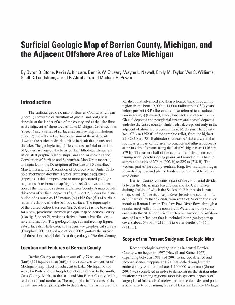
Surficial geologic materials in Berrien County (fig. 1, this pamphlet) are mostly nonlithified deposits of glacial, meltwater, alluvial, colluvial, eolian, marsh and swamp, lake-estuarine, and lake-bottom origin. Carbonate cement has lithified some glacial meltwater deposits and postglacial terrace deposits locally. Surficial materials are known also in engineering classifications as unconsolidated soils, which include coarse-grained soils, fine-grained soils, and organic fine-grained soils (fig. 2, this pamphlet). Surficial materials are
the parent materials of modern pedogenic soils, which have developed in them at the land surface.
Glacial deposits are composed of till (fig. 2, this pam-phlet), a nonsorted (diamict) clayey silt material contain-ing scattered sand grains and gravel particles, which forms resistant ridges and lake bluff-top carapaces. Glacial meltwater deposits, composed of loose gravel and coarse sand, are resis-tant to surface gully erosion and slumping due to rapid infiltra-tion of precipitation or thawed ground ice. In eastern Berrien County, these deposits form resistant landforms that preserve detailed evidence of the shape of supporting or buried ice masses and sedimentary depositional environments. Organic sediments in marsh, swamp, and lake estuarine deposits under-lie modern wetland areas. Eolian deposits are shown as units where they are >l m (˃3.3 ft) thick. Eolian silty fine sand, con-taining little clay and scattered gravel clasts with evidence of cryoturbation, overlies most glacial meltwater deposits in the upland areas, but is not shown on the map. Alluvial deposits underlie modern flood plains; older fluvial sediments compose
10256
2.564
.164
.082
.041
.02.5
.01
.25.005.125
.0025 Diameter, in inchesDiameter, in millimeters.062
.00015.004
Gravel deposits
Gravel particles Sand particles Fine particles
Sand and gravel deposits
Sand deposits
Boulders Cobbles Pebbles Granules Silt ClayVery
coarsesand
Coarsesand
Mediumsand
Finesand
Veryfine
sand
Fine deposits
(Ranges from 100 percent gravel particles to 75 percent gravel particles and 25 percent sand particles)
(Ranges from 50 percent sand particles and 50 percent fine particles to 100 percent fine particles)
(Ranges from 75 percent gravel particles and 25 percent sand particles to 25 percent gravel particles and 75 percent sand particles)
(Ranges from 25 percent gravel particles and 75 percent sand particles through 100 percent sand particles to 50 percent sand particles and 50 percent fine particles)
Coarse-grained deposits (greater than 50 percent sand and (or) gravel particles)
Stratified deposits (sorted and layered)
Till deposits (nonsorted)
(Mixtures of gravel, sand, and fine particles in differing proportions)
Figure 1. Grain-size classification of sedimentary particles, meltwater deposits, and till. Based on classification of Wentworth (1922).
Previous Geologic Studies and Maps of the Berrien County Region 3
CLAYEYTILLS
SANDYTILLS
SILTY TILLS
Clayeytills
Sandytills
Silty tills
Perc
ent c
lay
Percent silt
Percent sand
U.S. Department of Agriculture soil textures
c
c
cl
cl
sic
sic
sicl
sicl
sil
sil
si
si
s
s
l
l
ls
ls
sl
sl
scl
scl
sc
scClay
Silt
Sand
Loam
Sandy clay
Silty clay
Sandy clay loam
Silty clay loam
Clay loam
Silt loam
Sandy loam
Loamy sand
EXPLANATION
100
100100
80
80
80
60
60
6040
40
40
20
20
20
00
0
Figure 2. Ternary diagram showing grain-size classification of matrix of sandy, silty, and clayey tills, based on U.S. Department of Agriculture soil texture classification. Limits of fields of compact basal tills are based on Sladen and Wrigley (1983).
stream-terrace deposits. Colluvial deposits are shown where they accumulated on hillslopes above erosional lake scarps.
All glacial deposits and glacial meltwater deposits in Berrien County are related to the late Wisconsinan glacia-tion of the Lake Michigan ice lobe (Leverett, 1899; Hansel and others, 1985) and its three regional recessional moraines, which cross the county from north to south. Moraine deposits are of two kinds: (1) till-ridge moraines composed chiefly of till at the surface (Lake Border and Valparaiso morainic systems) and (2) stratified moraines composed of glacial melt-water deposits (Kalamazoo and Valparaiso morainic systems). The Correlation of Surface and Subsurface Map Units shows the relative ages of numerous morainal till and meltwater deposits that accumulated locally in the moraines at the glacier margin during retreat of the ice lobe.
Glacial meltwater deposits are divided further into two general groups of map units, defined by their characteristic sedimentary facies components (Stone and others, 2004; Stone and others, 2005). Map units composed of deposits of glacial streams contain coarse sediments that are products of glaciofluvial braided-stream depositional environments. Units composed of deposits of glacial lakes contain more diverse sedimentary facies in coarse sediments that accumulated in
progradational glaciodeltaic environments, coarse sediments related to deep lacustrine-fan environments, and finer deposits that were laid down in distal or deep glacial lake-bottom envi-ronments. A single map unit in Berrien County may contain a single meltwater deposit, such as a distal glaciofluvial deposit (unit Qcgj), or a single ice-marginal delta (unit Qdc). Each single meltwater deposit is identified from its morphologic expres-sion and distribution of surface sediment textures. Each of these deposits is a morphosequence (Koteff and Pessl, 1981), mappable at detailed scale. Map units containing a single morphosequence or a series of contiguous morphosequences depict the local succession of deposits and sedimentary facies in different depositional basins adjacent to the retreating ice-lobe margin. In deposits of glacial lakes, map-unit overprint patterns show the distribution of fine-grained lake-bottom sed-iments as well as sand and gravel braided-stream deposits of delta topset beds. Map unit descriptions provide details about glacial lake dams and spillways, and drainage of the lakes.
The surficial deposits of Berrien County overlie mostly shale bedrock, which crops out only on the bottom of Lake Michigan. The bedrock geologic map of the county (fig. 3, sheet 2) shows the distribution of middle Paleozoic shale and carbonate units in the subcrop, which were the source areas of glacially eroded sedimentary materials incorporated in the overlying glacial deposits.
The purpose of the geologic maps of Berrien County is to present surface and subsurface geologic map information that is directly applicable to future geologic and hydrologic resource and hazards investigations and land-use decisions.
Previous Geologic Studies and Maps of the Berrien County Region
Bedrock Geology
Early knowledge of the subsurface bedrock shale forma-tions in Berrien County was derived from the earliest oil and gas exploration wells in the southwestern part of the Michigan basin (fig. 3, sheet 2). Distinctive shale and underlying carbon-ate rock units revealed that the shale units beneath Berrien County dip and thicken to the north-northeast, and thin to the south. The position of the county’s rock units on the south-western edge of the basin, north of the bordering Kankakee arch in Indiana, was understood by the late 1800s (Lane, 1902; Roen and Kepferle, 1993).
Subsequent stratigraphic analyses revealed that the base of the shallow bedrock shale units is the Traverse Group sub-surface unit (fig. 3, sheet 2), distinguished by its hard lime-stone top. Gray shale and thin limestone of the Traverse For-mation overlie the Traverse Group limestone. The stratigraphic interval encompassing the productive Devonian black shales includes two formations in the western Michigan region and extends from the base of the black, radioactive Antrim Shale
4 Surficial Geologic Map of Berrien County, Michigan, and the Adjacent Offshore Area of Lake Michigan
upward into the base of the gray and grayish-green Ellsworth Shale. The Antrim black-shale sequence of the central Michi-gan basin is interbedded with basal greenish-gray shales of the Ellsworth Shale in western Michigan (Newcombe, 1932, 1933; Riggs, 1938; Bishop, 1940; Hale, 1941; Tarbell, 1941; Ells, 1979), demonstrating the facies relationship between the deepwater Antrim and the coarser, more proximal Ellsworth Shale at the western edge of the basin (Fisher, 1980; Harrell and others, 1991; Matthews, 1993). The gray to light-green Coldwater Shale, traditionally considered to mark the base of the succeeding shale-sandstone sequence of Mississippian age, overlies the Ellsworth. Over a large area of western Michigan the base of the Coldwater Shale contains a distinct marker bed of red limestone and shale, referred to as Coldwater Red Rock. Biostratigraphic correlations dated by global conodont biozonation have determined the Middle and Late Devonian age of the Traverse Group, the Late Devonian age of the black Antrim Shale unit, and the Lower Mississippian boundary at the base of the Coldwater Red Rock marker bed (Gutschick and Sandberg, 1991b).
Late Mesozoic to Tertiary Erosion
Beginning with regression of the Pennsylvanian sea and regional erosion at the base of lower Mesozoic continental fluvial red beds in the central Michigan basin, the bedrock of southwestern Michigan underwent a prolonged interval of sub-aerial erosion. The erosional surface extended west and north to the shallow intracontinental seaways during the Cretaceous (Reed and others, 2005). The upper parts of the Ellsworth Shale and Coldwater Shale, and probable thin Pennsylvanian strata, were removed from the Berrien County area during the Mesozoic and early Cenozoic Eras. Streams flowed to the west and south, carrying the weathered rock to the Mississippi embayment. Later Tertiary gravel, preserved along modern lowlands of the Mississippi-Ohio River drainages, appears to be evidence of geomorphic surfaces developed on soft shale units that were younger routes of sediment conveyance to the embayment. Perhaps in the late Tertiary, an integrated river drainage basin developed over the shale outcrop belts beneath the present Great Lakes. Another major river valley probably extended into the Lake Michigan basin from the north (Thorn-bury, 1965, p. 215), centered over the Lake Michigan trough, but stratigraphically high above the present glacially scoured depression. In this preglacial time, Berrien County was posi-tioned at probable heads of tributary valleys of this drainage system in a landscape characterized by heavily vegetated, low rounded hills of weathered shale and wide valley bottoms cut in shale with local reaches graded to knickpoint riffles on resistant sandstone pavements. Such streams may have been centered over local lowland troughs at New Buffalo, Baroda-Hollywood, and east of Watervliet, all graded to the master streams in the Lake Michigan basin, high above the present glacially eroded bedrock surface.
Glacial Geology
The hilly surface of Berrien County displays north-north-east-trending belts of moraine deposits related to three late Wisconsinan glacial advances of the Lake Michigan ice lobe (Leverett and Taylor, 1915; Martin, 1955). Leverett (1899) differentiated moraines composed of till deposits in discrete ridges, and moraines composed of a variety of sorted and stratified sediments and nonsorted glacial drift. The variably composed moraines reportedly contain loamy surface glacial drift (Leverett and Taylor, 1915), and are associated with fan-shaped outwash deposits. All of the loamy drift, commonly in multiple ridges, and related outwash deposits were combined in the concept of a morainic system (Leverett and Taylor, 1915) that could be traced laterally across the region. These till-ridge and variably composed (stratified) morainic systems (shown in the Correlation of Surface and Subsurface Map Units on sheet 1) remain the basis of the glacial chronologic framework in the region (Fullerton, 1980; Mickelson and oth-ers, 1983; Farrand and Bell, 1982; Lineback and others, 1983; Hansel and Johnson, 1996; Stone, 2001).
From east to west (oldest to youngest) in Berrien County, the three moraine belts are known as the Kalamazoo, Val-paraiso, and Lake Border morainic systems (fig. 1, sheet 2). Leverett and Taylor (1915) and Martin (1955) identified a local, high deposit (unit Qoko) that they correlated with the Kalamazoo moraine. Subsequent regional maps and sum-maries (Martin, 1955; Farrand and Eschman, 1974; Farrand and Bell, 1982) described readvances of the Lake Michigan ice lobe that produced the Kalamazoo morainic deposits. Retreat of the ice margin from the inner Kalamazoo moraine into the Lake Michigan basin has been estimated at about 15,000 radiocarbon years B.P. (Fullerton, 1980; Mickelson and others, 1983; Hansel and others, 1985). Regional maps and stratigraphic summaries (Leverett and Taylor, 1915, p. 30, 62; Fullerton, 1980; Lineback and others, 1983; Larson and Monaghan, 1988; Hansel and Johnson, 1996) have correlated the sandy loamy till of the Kalamazoo morainic system with the Ganges till of southwestern Michigan and with the sandy diamicton of the Haeger Member of the Lemont Formation in Illinois, deposited between 16,200 and 15,500 radiocarbon years ago.
The Valparaiso morainic system has been correlated with a glacial readvance around 14,800 radiocarbon years B.P. (Ful-lerton, 1980) from its retreatal extent in the Lake Michigan basin (Hansel and others, 1985). Multiple ridges in the Lake Border moraine in northern Illinois have been correlated with repeated recessions and readvances of the ice margin from the Lake Michigan basin between 14,500 and 13,500 radiocarbon years B.P. (Hansel and others, 1985). Sandy, loamy, and clayey tills of the Valparaiso and Lake Border morainic systems have been correlated tentatively with the Saugatuck till of Michigan, the Wadsworth Till of Indiana, and the Wadsworth Formation of Illinois, deposited between 15,500 and 13,800 radiocarbon years ago (Larson and Monaghan, 1988; Hansel and Johnson, 1996).
Bedrock Surface Topography 5
Table 1 summarizes the water-plane altitudes and ages of large ice-marginal glacial lakes that formed in Berrien County during glacier retreat, and the succeeding lakes in the Lake Michigan basin that effected erosion and deposition of coastal sediments in the county. Glacial Lake Dowagiac was the first extensive ice-marginal lake documented with regional extent whose origin was due to ice-margin retreat from the inner Kalamazoo moraine (Russell and Leverett, 1908). Other high ice-marginal lakes in southwestern Michigan and northern Indiana (Cressey, 1928; Schneider, 1983; the “border lakes” of Fullerton, 1980, pl. 1) were separated from the “incipient” phase of glacial Lake Chicago (Leverett and Taylor, 1915, p. 227) to the west by the ice-front edge on local low divides.These high ice-marginal lakes have been correlated regionallywith the Tinley moraine and parts of the Lake Border morainicsystem to the west. Presumably they relate to the oldestdeposits of glacial Lake Chicago, the “Early Lake Chicago”phase (Hough, 1958, 1963; Fullerton, 1980; Schneider andNeed, 1985), which formed during ice-margin retreat fromthe Valparaiso moraine to ice readvance to the Tinley moraine(Bretz, 1951). Hansel and others (1985, fig. 3a) correlatedthe earliest Glenwood I phase of glacial Lake Chicago withconstruction of the Lake Border moraines in Michigan. Suc-ceeding levels of Lake Chicago and younger lakes in the LakeMichigan basin acted as base levels for meltwater terraces inBerrien County, as well as for littoral deposits, lower streamterraces, groundwater springs and tufa development, andflood-plain sediments of the major stream valleys. The lakelevels, regionally dated ages of these lakes (table 1), and corre-lated deposits in Berrien County include the deposits of glaciallakes Madron, Dowagiac, and Baroda (Stone, 2001). Detailsof the history of lake levels in the Lake Michigan and LakeHuron basins were reviewed by Hansel and others (1985) andKincare and Larson (2009).
Table 1. Postglacial lakes and levels in the Lake Michigan basin, 15,500? 14C years ago to present.
[Compiled from Fullerton (1980), Hansel and others (1985), Eschman and Karrow (1985), Larsen (1987), Lewis and Anderson (1989), Schneider and Hansel (1990), Larson and others (1994), Colman and others (1994), Baedke and Thompson (2000), and Kincare and Larson (2009). Elevations in parentheses are in meters above sea level. B.P., before present]
Age, in 14C years B.PPostglacial lakes and levels in the
Lake Michigan basin
15,500? Madron (231)Dowagiac (224)
Baroda (215–201)
14,000 Glenwood I, Lake Chicago (195)Mackinaw (170?)
13,000 Glenwood II, Lake Chicago (195)
12,000Calumet? (189)Two Creeks (170)Calumet (189)Toleston? (184)Main Algonquin (184)
11,000Main Algonquin (descending)
North Bay opens, ending successively lower Algonquin phases
10,000 Chippewa (75)Mattawa floods
9,000Rebound-driven lake-level riseOlsen Forest Bed (153)
8,000Sanilac Forest Bed (165)
7,0006,0005,000 Nipissing (184)4,000
Algoma (181)3,000
Present level of lake reached around 2,200 years B.P. (178)2,000
Bedrock Surface TopographyThe surface of fresh, nonweathered shale bedrock lies
12 to ˃152 m (40 to >500 ft) below the land surface of Ber-rien County (figs. 2 and 3, sheet 2). New subsurface data permit revision of the previously contoured bedrock-surface topography beneath Berrien County (D. Daniels, Michigan Department of Environmental Quality, in Michigan Geologi-cal Survey Division, 1987; Winters and Reick, 1982). Bedrock drill-hole data include 120 exploratory and production wells for oil and gas resources, 4 U.S. Geological Survey (USGS) stratigraphic holes that penetrated rock, as well as 3 deep USGS holes that did not penetrate rock (appendix 1). Some of the 24 time-domain electrical resistivity soundings were calibrated with known depths to the low resistivity anomaly at the top of bedrock; other soundings supplied estimates of the altitude of the top of rock in isolated localities where other data did not exist. An airborne resistivity survey imaged the highly conductive bedrock and groundwater anomaly beneath surficial deposits along cross section C‒C′ north of the Three Oaks-Dayton area. A land-based seismic reflection profile beneath Range Line Road detected a discontinuous
bedrock-surface reflector. Lake-based seismic reflection pro-files in the coastal zone shoreface and in the lower St. Joseph River valley also imaged reflectors on hard basal till deposits and the bedrock surface. Oil and gas drill holes and deep well data from adjacent northern Indiana were used to extend the bedrock surface south of Berrien County. Descriptions from 130 water wells in surficial deposits, >45.4 m (>149 ft) deep, further constrained the bedrock-surface contours across the county. Contours on the bedrock surface were constructed in successive iterations using the nominal bedrock-surface altitudes at each data point and maximum-altitude constrain-ing values from the deep water wells. Contours were drawn and smoothed by hand, allowing extrapolation of high and low
6 Surficial Geologic Map of Berrien County, Michigan, and the Adjacent Offshore Area of Lake Michigan
areas and interpolated smooth slopes between ridgetop and lowland axes with smooth surface gradients. Local overdeep-ened, closed depressions were permitted where two or more bedrock-surface data points demonstrated depth and closure of the depressions. The bedrock-surface contours are general-ized because of lack of data; they depict a smooth rock surface showing detailed topographic expression only in the area of the resistivity survey along section C‒C′ and in areas at river knickpoints.
The bedrock-surface contours show a glacially modified erosion surface cut into the shale bedrock, characterized by overdeepened, narrow and wide lowland troughs and closed-contour lowland basins. In the western part of the county, a lowland trough beneath New Buffalo slopes to the west, and a trough beneath Baroda slopes to the northwest. The position and slopes of these troughs indicate that they developed from fluvially eroded valleys in a north-draining drainage basin, perhaps having a trunk stream coincident with the outcrop belt of black shale in the area of the Lake Michigan basin. Contours in the southern Lake Michigan subbasin show clo-sure of that depression below an altitude of 105 m (344 ft), the level of the bedrock-floored ridge separating it from the north-ern subbasin. The variable gradients along the centerlines of the Berrien County lowland troughs and the presence of closed depressions further indicate that multiple subglacial erosion events deepened and widened the preglacial stream-valley features. Rounded upland plateaus and ridges are preserved between the glacially scoured valley troughs and depressions. Some of the rounded upland knobs are known from drill-hole records to coincide with hard, erosionally resistant carbonate lenses in the shale. The bedrock surface shows >134 m (>440 ft) of relief, from the high point in a knob at >207 m (>680 ft) altitude southeast of Buchanan, to altitudes <91 m (˂300 ft) in the lowland at New Buffalo and <73 m (˂240 ft) offshore near Mizpah Park.
Thickness of Glacial and Postglacial Deposits
The map showing the total thickness of surficial deposits in Berrien County (fig. 2, sheet 2) was derived from gridded models of the surface topography and the buried bedrock surface. Total thickness values range from <1 m (˂3.3 ft) to 150 m (492 ft). In a few areas, too small to show in figure 2 (sheet 2), total thickness as much as 160 m (525 ft) has been calculated. The principal features of the map are related to the deep erosional troughs and intervening ridges and plateaus of the bedrock surface (fig. 3, sheet 2). Thickness values >60 m to 150 m coincide with the bedrock troughs at New Buffalo, Baroda, Mizpah Park, and Dayton. Trends of these thick zones continue beneath thick glacial deposits in Niles and along U.S. Route 12 to the southern border of the map. Thick deposits extend offshore at New Buffalo and west of Mizpah Park, but thickness values decrease lakeward because of the
lack of glacial deposits on top, the result of coastal erosion during changes in lake levels. Areas of thinner deposits, <30 m (<98 ft) thick, coincide with the broad area of shallow bedrock and rock outcrops offshore, the bedrock ridge at St. Joseph, the rock plateau area east of Baroda, and local plateaus in the southern part of the map area. Thickness values are mini-mal over bedrock knobs, notably south of Buchanan. Abrupt changes in thickness coincide with areas of deep erosion of the surface of the constructional glacial and postglacial deposits. For example, coastal erosion along lake bluffs, especially in glacial moraine deposits at Mizpah Park, has produced thick-ness changes from 45 m to 120 m (147 ft to 394 ft). South of St. Joseph, coastal sand dunes coincide with changes from 10 m to 90 m (33 ft to 295 ft) total thickness. Deep erosion in the St. Joseph River valley from Niles to Berrien Springs can be traced (fig. 2, sheet 2) where thickness values change from 21 m to 75 m (69 ft to 246 ft). Minimal thickness values are present where the river overlies the bedrock surface (figs. 2 and 5, sheet 2). Likewise, the Paw Paw River valley coincides with low thickness values in its lower reach. Other, smaller features of thickness values are related to the details of con-structional topography of deposits and local erosion, such as ice-contact slopes, deep kettle depressions, and local tributary stream valleys.
Lithostratigraphy of Berrien County
Bedrock Lithostratigraphy
The provisional bedrock geologic map (fig. 3, sheet 2) shows the subsurface distribution of presently defined Devo-nian and Mississippian lithostratigraphic units beneath Berrien County. Revised bedrock-surface structure contours, drillers’ descriptions of fresh shale and carbonate rock samples from oil and gas drill holes, and data from water and environmental drill holes and from USGS stratigraphic holes are the basis for the map shown in figure 3 (sheet 2). The bedrock geologic map revises previous regional maps (Michigan Geological Survey Division, 1987; Gutschick and Sandberg, 1991a; Reed and others, 2005) by use of additional data that define the bur-ied topography of the bedrock surface and by use of recently revised regional correlations of the stratigraphic units and their biostratigraphic correlations, based on the global conodont biostratigraphic zonations of the Devonian and Mississippian Periods (Gutschick and Sandberg, 1991a,b; Sandberg and others, 1994).
Bedrock lithostratigraphic units include formal strati-graphic units and informal units that are correlated with subsurface nomenclature (fig. 3, sheet 2) defined in the stratigraphic summary of the Michigan basin (Catacosinos and others, 2001). This summary includes recent revisions of the lithostratigraphy of western Michigan and the central Michigan basin (Ells, 1979; Gutschick and Sandberg, 1991b; Matthews, 1993) and revised ages of the carbonate and shale units. The distribution and subcrop patterns of bedrock units
Lithostratigraphy of Berrien County 7
are related to the thickness and shallow north-northeastward dips of the units, and their intersection with the buried bedrock surface. Drill-hole stratigraphic picks control the altitudes of unit contacts across the map.
The distinctively hard Traverse Limestone (subsurface unit; Middle Devonian) of the Traverse Group (map unit Dtg) defines the base of the overlying shale sequence in Ber-rien County (Riggs, 1938; Ells, 1979; Fisher, 1980; Mat-thews, 1993; Catacosinos and others, 2001). The Traverse Group (Grabau, 1902; originally the Little Traverse Group of Winchell, 1874) includes four formations, the uppermost of which is further subdivided into nine Members (Warthin and Cooper, 1935, 1943) in its area of outcrop in the northern part of southern Michigan. In the subsurface, this group of carbon-ate and shale units is termed the Traverse Limestone (top) and Bell Shale (base). The Traverse Limestone is present in the subcrop of the deepest parts of the New Buffalo trough in the southwestern part of Berrien County. In the county, the Tra-verse reportedly is 6 to 14 m (20‒45 ft) thick, consistent with regional isopachous values based on stratigraphic analysis of drill-hole gamma-ray logs (Matthews, 1993). The underly-ing middle and lower parts of the Traverse Group reportedly contain limestone, dolomite, and shale.
The Traverse Formation (Winchell, 1861; Riggs, 1938; Middle Devonian), also known as the Traverse Shale (Ells, 1979) is the top unit of the Traverse Group, where it dis-conformably overlies the Traverse Limestone. The Traverse Formation, presently an informal subsurface term (Hake and Maebius, 1938; Matthews, 1993), is composed of light-gray shale, shaly dolostone, and shaly limestone, locally fossil-iferous, and locally interbedded thin black shale beds. The Traverse Formation is present in the subcrop of the deepest parts of the New Buffalo trough. The upper gray shales of the Traverse reportedly are gradational with and into the overly-ing dark Antrim Shale, indicating possible continuous, though transitional, sedimentation with the base of the Antrim (Riggs, 1938; Ells, 1979; Matthews, 1993; Catacosinos and others, 2001). The Traverse Formation reportedly is <9 m (˂30 ft) thick in Berrien County (fig. 6 in Matthews, 1993).
The Antrim Shale (Lane, 1902; Upper Devonian) is a distinctive black to dark-gray shale that overlies the Traverse Formation and lies beneath the Ellsworth Shale (Fisher, 1980; Wold and others, 1981; Kluessendorf and others, 1988; Gutschick and Sandberg, 1991b; Dellapenna and others, 1991; Matthews, 1993; Catacosinos and others, 2001). The Antrim is hard, brittle, pyritic, and carbonaceous, locally containing thin beds of gray shale and limestone, and concretions com-posed of bituminous limestone. The Antrim Shale is present in the subcrop of the troughs beneath New Buffalo and north of Galien. In Berrien County the Antrim Shale is the lower Antrim informal unit of Matthews (1993). Regional analy-sis of drill-hole gamma-ray logs (fig. 19 in Matthews, 1993) indicates that his lower Antrim informal unit may thicken from about 20 m (65 ft) in the southern part of Berrien County to 24 m (80 ft) in the northern part. The Antrim Shale reportedly ranges from 22 to 35 m (73‒115 ft) thick in the southern part
of the county to 40 to 50 m (130‒165 ft) thick in the middle and northern parts of the county. Maximum thickness values of 55 and 68 m (181 and 224 ft) in northern Berrien County probably reflect the interbedded nature of the contact between the upper part of the unit and the overlying Ellsworth Shale and the difficulty of establishing a consistent marker horizon at the top of the Antrim. The Antrim Shale probably correlates chiefly with the lower part of the (middle) Lachine Member of the Antrim Shale of Gutschick and Sandberg (1991a). The reported occurrence of lime, shells, and carbonate in the lower part of the Antrim indicates that the lowest beds of the unit in the southwestern corner of Berrien County may be equivalent to the basal Norwood Member of Gutschick and Sandberg (1991a).
The light Antrim zone, which also is known as the lower Ellsworth Shale (Newcombe, 1932, 1933; Upper Devonian) is here designated as an informal subsurface term that follows regional usage of drillers’ subsurface terms “light Antrim” and “upper Antrim,” which refer to the interbedded sequences that contain the brown shales of the lower Ellsworth. This zone is a sequence of gray to light-brown shale that contrasts with the dark shales of the underlying Antrim Shale and the typical grayish-green shales of the overlying Ellsworth Shale (Fisher, 1980; Gutschick and Sandberg, 1991a; Dellapenna and others, 1991; Matthews, 1993; Catacosinos and others, 2001). The light Antrim zone also contains siltstone and minor sandstone, is locally calcareous, and contains shells, chert, and typically alternating light-brown, gray, and green shale sequences. The light Antrim zone is part of the Ellsworth/upper Antrim informal unit of Matthews (1993). The lower Ellsworth is present at the subcrop erosional surface in the bedrock troughs in the southern part of Berrien County. The light Antrim zone thickens from 8 m (25 ft) in the northern and southern parts of the county to 61 m (200 ft) in the central part, where the maximum thickening effects from the Ellsworth Shale may be located. The light Antrim zone is a transitional facies with the underlying, typical dark shale sequence of the Antrim Shale, and is part of the western prodeltaic facies equivalent of the upper part of the Antrim Shale to the east.
The Ellsworth Shale (Newcombe, 1932, 1933; Upper Devonian) is a subsurface unit in Berrien County and was originally designated as the upper gray and lower light-brown (light Antrim zone) shale sequence in western Michigan that lies below the informal Red Rock unit at the base of the Cold-water Shale and above the dark shales of the Antrim Shale. Later work further described the upper part of the Ellsworth Shale, above the informal lower Ellsworth Shale unit, con-sisting of green, grayish-green, bluish-green, and blue shale, locally very hard, with siltstone or minor sandstone lenses, and locally containing lime shells, lime streaks and limestone stringers, and chert (Riggs, 1938; Ells, 1979; Fisher, 1980; Gutschick and Sandberg, 1991b; Dellapenna and others, 1991; Matthews, 1993; Catacosinos and others, 2001). The lower part of this Ellsworth grayish-green shale sequence is the western prodeltaic facies equivalent of the upper part of the Antrim Shale to the east (Ells, 1979), and is the western part of
8 Surficial Geologic Map of Berrien County, Michigan, and the Adjacent Offshore Area of Lake Michigan
the Ellsworth/upper Antrim informal unit of Matthews (1993). The higher parts of the upper Ellsworth also relate to the Bed-ford Shale and Berea Sandstone, which are stratigraphically above the Antrim Shale of eastern Michigan (Swezey, 2008). The upper Ellsworth Shale is present in the subcrop over most of the central and southern parts of Berrien County. Regional analysis of drill-hole gamma-ray logs (fig. 18 in Matthews, 1993) indicates that grayish-green shales of the upper Ells-worth thicken from about 107 m (350 ft) in the southeastern corner of Berrien County to 143 m (470 ft) in the northwestern corner. In central and northern Berrien County, where it is reported beneath the Red Rock unit of the Coldwater Shale, the Ellsworth totals 131 to 152 m (430‒500 ft) in thickness.
The informal Coldwater Red Rock has long been known as a drillers’ marker unit of the Coldwater Shale (Smith, 1912; Lower Mississippian) that consists of red shale and red shaly limestone and disconformably overlies the grayish-green shales of the Ellsworth Shale across much of western Michi-gan (Newcombe, 1932; Matthews, 1993). The red rock zone is at the base of the Coldwater Shale in the central and northern part of Berrien County. It varies in thickness from 0.3 to 4.6 m (1‒15 ft). The red rock unit is present along the upper part of slopes, bounding ridges, and plateaus of the buried bed-rock surface of the county. In some drill holes, red rock was not recorded at the base of the Coldwater. The hematitic red color of the red rock zone apparently resulted from accumula-tion of weathered shale and soil materials in the unit, related to previous regional subaerial exposure and weathering of the Ellsworth Shale (Newcombe 1932, 1933; Gutschick and Sandberg, 1991b).
The Coldwater Shale (Lane, 1899; Smith, 1912; Lower Mississippian) is gray to light-green shale and siltstone, which commonly includes the Coldwater Red Rock marker unit at the base, overlying the Ellsworth Shale (Newcombe, 1932; Matthews, 1993; Catacosinos and others, 2001). Drillers report that the Coldwater Shale is chiefly gray or green, but also includes grayish-green, bluish-green, and blue shale. It report-edly contains local microcrystalline limestone and dolostone, lime streaks and limestone stringers, lime shells, and chert. The Coldwater Shale underlies the northern part of Berrien County and the high bedrock ridges and knobs to the south. In northern Berrien County the Coldwater reported in drill logs is 3 to 10 m (10‒33 ft) thick. The unit reportedly is >64 m (˃210 ft) thick above the red rock zone in a bedrock ridge near Coloma.
Lithostratigraphy of Surficial Deposits
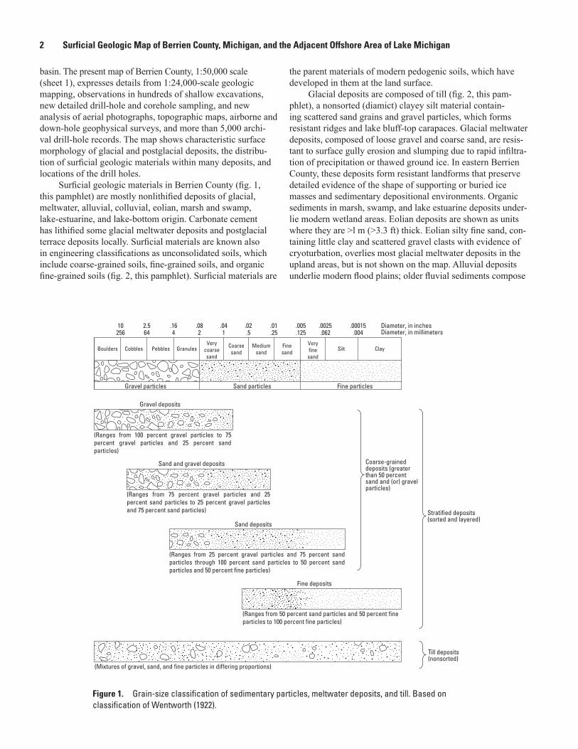
Classifications of surficial deposits of glacial origin commonly are used to subdivide the materials on the basis of grain-size characteristics, origin, sediment composition, and relative age (figs. 1 and 2, this pamphlet) (Willman and Frye, 1970; Lineback and others, 1983; Hansel and Johnson, 1996; Stone and others, 2002). The surficial geologic map (sheet 1) shows the distribution of such lithically defined till, meltwater,
and postglacial deposits beneath Berrien County. It is recog-nized that lithologically distinct, widespread, mappable till units should be designated as formation rank, and that these form the basis of correlation with ice-margin advance and retreat chronology, shown by till moraines and other events (Lineback and others, 1983; Hansel and Johnson, 1996). Tills in Berrien County previously were distinguished as informal units, either as clayey till, loamy till, or sandy loamy till in ground and end moraines (Leverett and Taylor, 1915; Farrand and Bell, 1982; Lineback and others, 1983), similar to tills farther north in Michigan. Monaghan and others (1986) pro-posed three regional till units in southwestern Michigan based on correlation of silty tills exposed at the surface of the Lake Border morainic system in Allegan County with those seen in well logs in the subsurface. They used clay mineralogy to dif-ferentiate the tills, from youngest to oldest, as the Saugatuck till, Ganges till, and Glenn Shores till.
Surface till deposits in Berrien County appear to have similar lithic components across the county, characterized by their calcareous, clayey silt matrix derived from the local gray, green, and black shales, and containing shale, siltstone, sandstone, and distinctive erratic metamorphic and igneous rock clasts (Lineback and others, 1983; Stone, 2001). Surface tills of the Lake Border and Valparaiso morainic systems are correlated tentatively with the Saugatuck till, the Wadsworth Till of Indiana, and the Wadsworth Formation of the Wedron Group of Illinois (Hansel and Johnson, 1996). The occurrence of reddish-brown till in the Valparaiso moraine near Coloma is related to the local source of reddish-brown shale of the underlying Coldwater Shale Red Rock zone. Characteristics of the basal till inferred to underlie the Kalamazoo morainic deposits in eastern Berrien County are not known, but this till may correlate with the Ganges till of Monaghan and others (1986) and possibly with the Haeger Member of the Lemont Formation of Illinois (Hansel and Johnson, 1996). All of these tills associated with the Lake Border, Valparaiso, and Kalama-zoo morainic systems in the southern Lake Michigan basin are correlated with the Michigan Subepisode of the Wisconsin Episode (Karrow and others, 2000), and the previous and present Woodfordian Substage of the Wisconsinan Stage of northern Illinois (Hansel and Johnson, 1996).
Lithostratigraphic frameworks typically divide glacial meltwater deposits into two formation-rank or informal groups: coarse-grained glacial stream and deltaic deposits, and fine-grained glacial-lake deposits (Willman and Frye, 1970; Hansel and Johnson, 1996; Stone and others, 2002). The sur-ficial geologic map (sheet 1) shows the distribution of similar coarse-grained and fine-grained units in Berrien County. The coarse-grained group formerly was recognized as a regional unit having distinct lithic components: rounded, generally nonweathered gravel clasts, composed of metamorphic and igneous erratic rock types, sandstone, conglomerate, carbon-ate, and shale. Sand composition is variable, from lithic coarse sand to sublithic fine sand (Lineback and others, 1983; Stone, 2001). Map units in the coarse-grained group previously were related to their morphologic expression and sediment grain
Glacial Stratigraphy of Berrien County 9
size: ice-contact sand and gravel, outwash sand and gravel, and lake sand and gravel (Farrand and Bell, 1982; Lineback and others, 1983). Exposures reveal a variety of glaciofluvial sedimentary facies in the upper parts of these deposits, from coarse gravel, to sand and gravel, to coarse pebbly sand. Deeper excavations expose glaciodeltaic sand and gravel and sandy foreset facies, and sandy delta bottomset facies. Fine-grained glacial-lake deposits in Berrien County include very fine sand-silt facies, and silt-clay lake-bottom facies.
On the geologic map (sheet 1), coarse-grained meltwater deposits are subdivided into numerous informal units related to their origin in proglacial streams and glacial deltas in lake basins that existed across the county. Fine-grained glacial-lake-bottom deposits also are subdivided into informal units related to the locations of the deep glacial-lake basins in the county. The coarse-grained and fine-grained deposits, respec-tively, are correlated with the Atherton and Martinsville For-mations in Indiana (Wayne, 1963), and the Henry Formation (glaciofluvial) and Equality Formation (glaciolacustrine) of the Mason Group in Illinois (Hansel and Johnson, 1996). All of these meltwater and glacial-lake deposits associated with the Lake Border, Valparaiso, and Kalamazoo morainic systems in the southern Lake Michigan basin are correlated with the Michigan Subepisode of the Wisconsin Episode (Karrow and others, 2000) and the previous and present Woodfordian Substage of the Wisconsinan Stage of northern Illinois (Hansel and Johnson, 1996).
Glacial Stratigraphy of Berrien County
Quaternary Morainic Systems
The three late Wisconsinan recessional moraines of Berrien County consist of thick, laterally continuous bod-ies of glacial and meltwater deposits that descend in steps from the highest and oldest Kalamazoo moraine in the east, to the Valparaiso moraine, and from there to the Lake Border moraine in the west (fig. 1, sheet 2). For the purposes of this report, these moraines are referred to as morainic systems, in order to emphasize the variable morphology and composition of each system within the context of regional correlation of these markers of ice-margin recessional events (Leverett and Taylor, 1915). The till-ridge morainic systems (Lake Border and local Valparaiso morainic systems) consist of multiple, elongate moraine ridges separated by till plains and lake-bottom plains. The till ridges continue in the subsurface as till sheet deposits, interbedded with glacial-lake deposits. In other more proximal areas, ice-marginal deltaic or distal meltwa-ter deltas may be components of till-ridge morainic systems (Blewett, 1991). The stratified morainic systems (Valparaiso and Kalamazoo morainic systems) are composed of multiple ice-marginal glacial deltas and glaciolacustrine fans that form a contiguous array of deposits, welded together at their onlapping contacts, further related by the accordant altitudes
of their delta topset plains. Their bounding ice-contact slopes repeatedly are aligned parallel to the regional trend of the receding ice margin. Some of these slopes are underlain by till deposits related to minor ice-margin readvances at the heads of some deposits. The Correlation of Surface and Subsurface Map Units on sheet 1 shows the relative ages of numerous morainal till and meltwater deposits that accumulated locally in the morainic systems at the glacier margin during retreat of the ice lobe. The numerous map units within each moraine system display morphologic and stratigraphic features that are evidence of depositional processes active during the moraine-building episodes.
The regional lithostratigraphic correlations of glacial deposits place sediments in a broad framework related to dif-fering composition across areas of the Lake Michigan ice lobe (Hansel and Johnson, 1996) and related to the bedrock source of sediments. The morainic systems establish regional cor-relation of ice-margin advance and recessional events within and between areas. In order to investigate and predict the three-dimensional distribution of surficial materials in Berrien County, a system of smaller stratigraphic units and map units is required. These units share similar lithic characteristics but are located at different altitudes and positions in the morainic systems, and in different basins and stratigraphic successions across the county (Stone and others, 2006). The units, differentiated by their position and discontinuous bounding surfaces, are informal allostratigraphic units (North American Commission on Stratigraphic Nomenclature, 1983).
Deposits of Glacial Lakes in Stratified-Drift Moraines in Berrien County
Morphology and Sedimentary Characteristics of Glacial-Lake Deposits
Deposits of glacial lakes consist of all sediment deposited in or graded to temporary proglacial lakes impounded by dams composed of glacial drift to the south, and the retreating edge of the ice sheet to the north. Features graded to the water-plane level of each glacial lake include deltas, wave-eroded scarps, and rare beach deposits. All lake-level deposits in each lake have accordant altitudes, when adjusted for postglacial iso-static deformation, indicating the elevation of the lake-surface water plane.
Glacial-lake deposits consist of sand, sand and gravel, and silty sand in deltaic, glaciolacustrine fan, and ice-channel deposits; and fine sand, silt, and clay in lake-bottom deposits. Each map unit contains one or more allostratigraphic units, typically an ice-marginal or near-ice-marginal meltwater deposit, known as a morphosequence (Koteff and Pessl, 1981; Stone and others, 2004; Stone and others, 2005) and defined below.
10 Surficial Geologic Map of Berrien County, Michigan, and the Adjacent Offshore Area of Lake Michigan
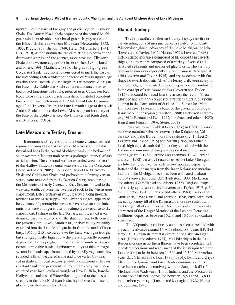
A morphosequence is a body of meltwater deposits composed of a continuum of landforms, grading from ice-contact forms (eskers, kames) to non-ice-contact forms (flat valley terraces, delta plains) that were deposited simultaneously at and beyond the margin of a glacier and graded to a specific base level. In Berrien County, morphosequences mostly are ice-
marginal (ice-contact) deltas (fig. 3, this pamphlet) deposited in glacial lakes that expanded northward as the ice sheet retreated. Each glaciodeltaic deposit consists of sand and gravel fluvial topset beds overlying dipping gravel and sandy delta foreset beds and thick sandy and silty delta bottomset and lake-bottom beds (cross sections A‒A′ and B‒B′, sheet 1). As deltas prograded from the ice margin into the lake basins, the distal lake-bottom deposits were succeeded vertically by deltaic bottomset, foreset, and topset strata. The topset-foreset contact closely approximates the level of the glacial lake, as does the altitude of the distal edge of the fluvial topset plain. Surface altitudes of the delta topset plains in deltas graded to the same lake level are accordant. Each deltaic morphose-quence is an informal unit, differentiated allostratigraphically, and related to others and the glacial-lake basin in a relative chronology. In Berrien County, the Kalamazoo and Valparaiso morainic systems are assemblages of deltaic morphose-quences. Although the most common morphosequences are fluviodeltaic, extending into glacial-lake basins from glacial stagnant-ice margins, there are some ice-contact deposits (such as Qhd) in which the sediment apparently filled large, evolving ice holes, and meltwater flowed over or through a stagnant ice selvage rather than a drift dam of a glacial lake. The resulting deposits are isolated clusters of rounded or flat-topped hills, bounded entirely by ice-contact slopes that are not linked evidently to a distal lake-bottom deposit. Compared to the glaciodeltaic stratigraphic succession (figs. 4‒14, sheet 2; unit Qcr (of the Valparaiso moraine) and unit Qikk (of the Kalama-zoo moraine) in cross section A‒A′), such stagnant ice-hole deposits are extremely variable in their vertical and lateral succession. These ice-hole deposits are another type of mor-phosequence, preserving a unique depositional ice-walled lake environment and correlated to isolated, ice-bounded basins by relatively high altitudes of the different deposits.
The morphosequence concept has been expanded in three-dimensional stratigraphy to include sedimentary facies within glaciofluvial and glaciodeltaic morphosequences (figs. 4‒14, sheet 2) (Stone and others, 2004; Stone and others, 2005; Stone, 2006). Ice-marginal deltaic deposits have sand and gravel glaciofluvial topset beds, which overlie deltaic foreset and bottomset facies. Foreset strata contain sand and gravel and sandy foreset facies; delta sandy bottomsets consists of fine sand, silt, and minor clay, as described in the Description of Surface and Subsurface Map Units. Total thick-ness of deltaic sediments is 6.1 to 45.7 m (20‒150 ft). Some of these deltas are connected to tributary ice-channel ridges, which contain sand, coarse gravel, and exposed boulders. Gla-ciolacustrine fans contain sand and gravel and sandy foreset
and bottomset facies, and minor till, flowtill, and fine-grained lake-bottom sediments. Lake-bottom deposits (dashed-line patterns) contain sandy and silt-clay facies. Total thickness of lake-bottom sediments is 3.0 to 61.0 m (10‒200 ft). The sur-ficial geologic map displays overprint patterns that show the textures of surface sedimentary facies, such as fluvial sand and gravel. Patterns in the cross sections show the structure and grain size of subsurface facies, such as collapsed delta foreset sand and gravel, and delta sandy foreset and bottomset strata (sheet 1). Map information portrays the extent and bounding discontinuities of subsurface facies (figs. 5‒12, sheet 2).
Lakes of the Kalamazoo and Valparaiso Morainic Systems
Deposits of five glacial lakes in the Kalamazoo (Qoko, Qikc, Qikk, and Qikp) and Valparaiso (Qcr) morainic systems are chiefly of deltaic origin, deposited in at least 12 ice-marginal deltas and included as five map units. Surface altitudes of the delta topset glaciofluvial plains are accordant within the hypsometric intervals 229‒285 m (750‒935 ft, unit Qoko), 250‒259 m (820‒850 ft, unit Qikc), 244‒250 m (800‒820 ft, unit Qikk), 244‒253 m (800‒830 ft, unit Qikp), and 223‒235 m (730‒770 ft, unit Qcr). Total thickness of deltaic deposits ranges from 77 m (252 ft) to 135 m (443 ft). In the Kalamazoo morainic system, ice recession of 12 km (7.5 mi) in a north-west direction is reflected by northeast-trending positions of deltas deposited along stagnant ice borders. The distinctly steep northwest-facing ice-contact slopes of deltas in the Kalamazoo moraine, and the small step-wise lowering of delta plains indicate that this assemblage of high glacial-lake deposits was formed in contact with a stagnant ice zone in proximity to a well-defined active ice margin. Spillways for these lakes were either over slightly older deltaic deposits east of Berrien County, or stagnant-ice dams. The highest altitude in Berrien County, 283.8 m (931 ft), is located in meltwater deposits correlated with the high deposits of the Kalamazoo morainic system. The inner Kalamazoo is correlated with the lower meltwater deposits of the Portage Prairie-Bainbridge Center area. Massive deposits of unit Qcr, in the Valparaiso morainic system, were deposited in an ice-marginal lake above the level of glacial Lake Dowagiac, dammed to the southeast by deposits of the Kalamazoo morainic system.
Glacial Lake Madron in the Valparaiso Morainic System
Glacial Lake Madron was the oldest and highest of the proglacial lakes associated with the Valparaiso morainic system. It occupied two narrow basins between the retreatal ice margin positions to the north and its dam to the south. The dam consisted of older deposits of the inner Kalamazoo morainic system on the southeastern side of the basins, includ-ing the massive Portage Prairie deltaic deposit (unit Qikp), and impervious stagnant ice in the present Buchanan-Niles

Glacial Stratigraphy of Berrien County 11
NORTH SOUTH
Sandy lake-bottom plain
Glaciofluvial delta topset plain
Ice-contact head of depositIce-margin line
Glacial ice
Delta foreset slopeKettle
Lake surface
Glaciofluvial coarse gravel facies—in terrace and glaciodeltaic deposits
Glaciofluvial gravel and sand facies—in glaciodeltaic and stream terrace deposits
Glaciofluvial coarse pebbly sand facies—in glaciodeltaic and stream terrace deposits
Glaciodeltaic sand and gravel foreset facies—view parallel to strike of foreset beds
Glaciodeltaic sand and gravel foreset facies—view oblique to strike or up the dip of foreset beds
Glaciodeltaic coarse sandy foreset facies—view parallel to strike of foreset beds
Glaciodeltaic coarse sandy foreset facies—view oblique to strike or up the dip of foreset beds
Glaciodeltaic fine sandy foreset facies—view parallel to strike of foreset beds
Glaciodeltaic fine sandy foreset facies—view oblique to strike or up the dip of foreset beds
Glaciodeltaic fine sandy bottomset facies and glaciolacustrine lake-bottom fine sand facies
Glaciolacustrine lake-bottom silty sand facies
Glaciolacustrine lake-bottom silt-clay facies
Deformed englacial and superposed sediment from ice at bottom of kettle structure
Collapse high-angle reverse and normal faults caused by melting of buried ice
Dominant trend of bedding in glaciofluvial deposits and glaciodeltaic sand and gravel and coarse sandy foreset facies
Dominant trend of bedding in glaciodeltaic fine sandy facies
EXPLANATION
METERS120
0
Figure 3. Generalized cross section showing sedimentary facies and collapse structures in a glaciodeltaic morphosequence. Vertical scale shows typical thickness of these deposits in Berrien County. Sedimentary facies (modified from Stone and others, 2004, 2005) and collapse-deformation symbols (McDonald and Shilts, 1975) are shown schematically. Because boundaries between facies typically are gradational or are inaccurately known, they are not shown by contact symbols.
12 Surficial Geologic Map of Berrien County, Michigan, and the Adjacent Offshore Area of Lake Michigan
area as well as south and west of the McCoy Creek drainage basin in northern Indiana. The lake basins originally drained through a spillway over older deposits in northern Indiana at a level of about 236 to 238 m (774‒781 ft), then through a lower spillway channel cut to 231 m (758 ft) altitude in sandy deposits along the western margin of the Portage Prairie delta (unit Qikp). The open water of the lake extended as a series of linked, local depositional basins through blocks of stagnant ice and successively collapsed deposits to the lake spillways. The level of glacial Lake Madron lowered when ice melted out of the Niles area, allowing drainage to the south along the distal (eastern) edge of the Portage Prairie delta at 231 m (758 ft) altitude. With further melting of extensive stagnant ice south of the McCoy Creek drainage basin in northern Indiana, gla-cial Lake Madron lowered to the initial level of a succeeding lake, glacial Lake Dowagiac.
Deposits of glacial Lake Madron are chiefly deltaic in origin and were deposited in at least nine ice-marginal deltas included in five map units (Qmrb, Qmw, Qmo, Qml, and Qmbe). Surface altitudes of the delta-topset glaciofluvial plains are broadly accordant within the hypsometric interval 229‒244 m (750‒800 ft) in central Buchanan Township. Surface altitudes slope from >253 m (˃830 ft) in some ice-contact outwash heads to 231 m (758 ft), the estimated altitude of the glacial-lake water plane. A delta topset-foreset contact at 231 m (758 ft) is exposed in a large gravel pit on the eastern side of unit Qmrb. The total thickness of deltaic deposits ranges from 55 m (180 ft) to 115 m (377 ft). Extensive lake-bottom deposits (unit Qml), as much as 100 m (328 ft) thick, are present in the subsurface beneath overlying deposits of glacial Lake Dowa-giac (units Qdlm, Qdg). Positions of the stagnant ice borders of selected deltas show the east-west trend of the glacial ice margin during ice recession of 8 km (5 mi) from southeast to northwest.
Glacial Lake Dowagiac in the Valparaiso Morainic System
Glacial Lake Dowagiac was the major ponded water body associated with the Valparaiso morainic system in Ber-rien County (Russell and Leverett, 1908; Leverett and Taylor, 1915; Stone, 2001). The dam for the lake was older deposits of the inner Kalamazoo morainic system on the southeastern side of the lake basin, including Portage Prairie deposits (unit Qikp). The first depositional basin of Lake Dowagiac formed in the area of the McCoy Creek drainage basin as ice melted away from the ice-contact heads of older deltas (units Qikp and Qoko). Lake Dowagiac initially spilled over the regional drainage divide along what is now the Indiana Toll Highway (Interstate Route 80) at an altitude of about 226 m (742 ft). Two large near-ice-marginal deltas prograded into this arm of glacial Lake Dowagiac, fed by distal glacial meltwater and meltwater from stagnant ice remaining in older adjacent deposits of glacial Lake Madron. The lake expanded north-ward as the ice margin retreated. The open water of the lake
extended as a series of linked, local kettle depositional basins through successively collapsed deposits to the second and principal lake spillway, which was a channel cut in sandy deposits (unit Qikp) at about 224 m (735 ft) altitude. Lake Dowagiac lowered suddenly when surface water from the lake carved a discharge channel through kettle basins in the Lemon Creek drainage, lowering the Dowagiac water level to about the initial level of glacial Lake Baroda, less than 219 m (720 ft) altitude. Final retreat of the ice margin from the west-ern limit of the Lake Dowagiac basin north of Berrien Springs allowed the two lakes to coalesce, probably at a subsequent lower level of Lake Baroda.
Deposits of glacial Lake Dowagiac (Russell and Leverett, 1908) are chiefly deltaic in origin and were deposited (1) in at least 21 ice-marginal deltas included in 12 map units (Qdc, Qdbn, Qdbi, Qds, Qdo, Qdb, Qdmt, Qdr, Qdlm, Qdg, Qdf, and Qdm), and (2) in 6 near-ice-marginal deltas included in 2 map units (Qdg and Qdm). Also included are five ice-channel deposits (all within Qdps) that probably were graded to the lake. Surface altitudes of the delta-topset glaciofluvial plains are accordant within the hypsometric interval 223‒238 m (730‒780 ft) in the eastern part of Berrien County from Buchanan to Coloma. Surface altitudes slope from points as high as 247 m (810 ft) in some ice-contact outwash heads to 224 m (735 ft), which is the estimated altitude of the glacial-lake water plane. Lake-bottom deposits are moderately well-sorted fine sand at the surface, and laminated gray very fine sand, silt, and clay in the subsurface. The surface of lake-bottom plains is at 195 m (640 ft) altitude in the southern lake basin (unit Qdlm), and 210 to 219 m (690‒720 ft) in the northern lake basins (unit Qdlu). Probable glaciolacustrine fan deposits and exten-sive lake-bottom deposits in the subsurface are included in one buried ice-marginal unit (Qdbh) in the Buckhorn area along the west-central margin of the lake basin. Positions of the stagnant ice borders of selected deltas show the east-west trend of the glacial ice margin during 25 km (15.5 mi) of ice recession from south to north.
Glacial Lake Baroda in the Lake Border Morainic System
Glacial Lake Baroda extended as a narrow ice-marginal lake in front of the retreating ice lobe to its eastern shore along the collapsed, ice-contact slopes of the Valparaiso morainic system in central Berrien County (Stone, 2001). The lake was dammed to the south by the massive deposits of the Valparaiso morainic system in northern Indiana. It expanded northward and westward as the ice margin retreated. At maximum extent Lake Baroda probably flooded basins to the southwest as far as the col in the drainage divide at Valparaiso, Ind., that is at a present altitude of 212 m (695 ft) (Stone and others, 2003). The lake at this level covered all but the highest pinnacles of Lake Border moraine ridges in Berrien County. Evidence of the northwesternmost margin of Lake Baroda is not preserved in the Lake Michigan basin west of Berrien County. Lake
Glacial Stratigraphy of Berrien County 13
Baroda lowered to the Glenwood I phase of glacial Lake Chicago (at 195 m (640 ft)) following retreat of the ice margin from the Valparaiso-Chesterton area of northern Indiana (Lev-erett and Taylor, 1915).
Deposits of glacial Lake Baroda are chiefly extensive, irregularly distributed lake-bottom deposits in lowland plains throughout the western extent of the county (surface unit Qblu). Lake-bottom plains reach maximum altitudes of 201 to 207 m (660‒680 ft). Deltaic deposits of unit Qbb appear to be proximal glaciofluvial deposits graded to the initial high phase of Lake Baroda. Surface altitudes of this collapsed glaciofluvial plain slope from 223 m to 213 m (730 ft to 700 ft). Littoral deposits of the lake extend along the eastern side of its basin on either side of where the mouths of the Pipestone River, St. Joseph River, and Lemon Creek would have been at altitudes of 201 to 207 m (660‒680 ft) and are seen as sandy deposits that display deltaic morphology. Here also are beach berms 201 to 206 m (660‒676 ft) in altitude, 1 to 6 m (3‒20 ft) thick, and offshore bars indicating shoreline-lake environments. Wave-cut lake-bluff scarps are present at similar altitudes along the ice-contact slopes of deltas of the Valparaiso morainic system on the eastern edge of the Baroda lake basin. Subsurface deposits of glacial Lake Baroda are chiefly lake-bottom sediments (units Qbll, Qblm) consisting of silt, fine sand, some clay, and little medium sand to granular gravel. These deposits fill the Elm Valley in the southern part of the county, where they are known to exceed 37 m (120 ft) in thickness, and where they extend continuously to Shoreham to the northwest and the St. Joseph River to the north and north-east. Lake-bottom sediments (units Qbll, Qblm) exist below till of the Lake Border moraine ridges (Qltl, Qltu) in the southern part of the county where the till-lake sediment sequences form successive wedge-shaped deposits that onlap older deposits and that extend to the floor of the glacial basin (cross sec-tions B‒B′, C‒C′). The onlapping lake-bottom sediments are inferred to consist of fine silty, ripple-laminated sand that rap-idly filled deep trough depressions in the glacial basin in front of the readvancing ice margin in Lake Baroda. At Mizpah Park beneath till of the inner Lake Border ridge (unit Qltu), lake sediments (unit Qblm) contain sand and gravel foreset facies that extend southward to sandy bottomset facies. In this part of the basin, Lake Baroda extended to an active coarse-sediment supply at the fluctuating ice margin. A corehole at Watervliet airport revealed 81 m (265 ft) of very fine lacustrine sand beneath sediment of the Paw Paw River terrace. This sequence probably records lake-bottom sedimentation in both glacial lakes Baroda and Dowagiac. Line symbols on the map trace the maximum extent of till deposits and the related extent of two readvances of the ice margin into the Lake Baroda basin.
Glacial Lake ChicagoLake-bottom deposits tentatively correlated with glacial
Lake Chicago are found in a small lowland lake plain north of New Buffalo in the southwestern part of the county (unit Qcgl). The lake-bottom plain attains a maximum altitude of
194 m (636 ft). The clayey deposits onlap older till deposits on the ice-proximal rampart of the inner Lake Border moraine ridge. Shallow subsurface projection of unit contacts indi-cates that these deposits are <10 m (˂33 ft) thick. Based on their position lakeward of the moraine ridge and their maxi-mum altitude, the deposits are correlated tentatively with the Glenwood I phase of glacial Lake Chicago. Alternatively, the deposits may be a distal part of upper Lake Baroda deposits (unit Qblu). Other deposits tentatively correlated with glacial Lake Chicago (unit Qcg) overlie the upper till deposit of the inner Lake Border moraine (unit Qltu) northwest of Riverside. These sediments are in an upward-fining, progradational sequence of crossbedded sand and pebble gravel, 9 m (30 ft) thick, containing a bed of imbricated cobble gravel at the base. The deposits extend upward to an altitude of 188 m (617 ft). A large conifer twig in the basal sand and gravel bed yielded a radiocarbon (14C) age of 13,470 years B.P., indi-cating that this sequence of strata may be a littoral deposit correlated with transgression of a lower Mackinaw phase lake to the Glenwood II phase of glacial Lake Chicago (Larson and Monaghan, 1988; Monaghan and Hansel, 1990), which attained its stable level of 189 m (620 ft) about 13,000 radio-carbon years ago.
Deposits of the glacial Lake Chicago Calumet phase (unit Qccb) include related beach, eolian dune, foreshore, and back-bay sediments in a lowland cuspate coastal plain south of Shoreham. The beach-berm (backshore) deposits reach maximum altitudes of about 190 m (623 ft). Deposits onlap older till deposits above an erosional inset sedimentary contact extending to the eroded moraine-ridge reentrant to the north. The Calumet phase may have been present at 189 m (620 ft) altitude as a brief, receding level following the Glenwood II phase of Lake Chicago (Hough, 1966, Hansel and Mickelson, 1988). The Calumet phase level also was attained after the advance of the Lake Michigan ice lobe into the upper basin at the end of the Michigan Subepisode after 11,850 radiocarbon years B.P. (table 1) (Colman and others, 1994; Mickelson and others, 1983).
Glacial Lake AlgonquinDeposits of glacial Lake Algonquin are not known in
Berrien County. The level of the lake (184 m (605 ft)) is also the level of the younger Nipissing lake phase. Wave-cut bluffs parallel to the present shoreline of Lake Michigan probably reflect action by both Algonquin and Nipissing lake phases. Areas below an elevation of 184 m exist in the incised valleys of the St. Joseph, Paw Paw, and Galien Rivers. However, these areas did not exist until the erosion of the valleys during the post-Algonquin, Chippewa low-lake phase. Some research has indicated that glacial Lake Algonquin was a low-lake phase in southern Lake Michigan due to the isostatic depression of the northern part of the basin (Larsen, 1987). This would imply that the sediments in the incised valleys could be from the Algonquin lake phase and may be found upon further explora-tion. Research by Capps and others (2007) however, has found
14 Surficial Geologic Map of Berrien County, Michigan, and the Adjacent Offshore Area of Lake Michigan
Algonquin lake-phase sediments along the southern shoreline of Lake Michigan (near the Calumet-phase type area), indicat-ing that it was a high-level lake throughout the lake basin.
Till and Moraine Ridge Deposits in Berrien County
Morphology and Sedimentary Characteristics of Till-Ridge Moraines
Surface till-moraine ridges in the Lake Border and Valparaiso morainic systems provide direct evidence of active ice-margin readvance into the western and central parts of Berrien County during general deglaciation of the region. The moraines consist of a single ridge or series of discontinu-ous, low, curved ridges that stand 6 to 12 m (20‒40 ft) above adjacent flat till plains and lake-bottom plains. Continuous, exposed moraine ridges vary in length from 0.7 to 18 km (0.4‒11.2 mi), and in width from 0.2 km to about 3.5 km (0.1 mi to about 2.2 mi). Ridgecrests, defined locally by only a single 5-m topographic contour, have symmetric cross sections andcurved, locally irregular crest traces. Ridgecrests in series arespaced 0.3 to 2.1 km (0.2‒1.3 mi) apart. Many higher till-moraineridges present a slightly asymmetric profile having the steeperside facing east. The flat till plains, present on either side ofmost till moraine ridges, are wider on the western sides ofmany of the exposed ridges. Combined with the ridgecrests,the overall asymmetric profile is inferred to extend into thesubsurface (cross sections B‒B′, C‒C′). Drill-hole and geo-physical information on the eastern sides of these ridges indi-cate a steep front bordered by onlapping lake sediments.
Each moraine ridge crest probably marks a stabilized ice-margin position behind the line of maximum ice extent. Thin till beds, perhaps debris-flow deposits, and fine, sandy lake-bottom deposits underlie parts of the frontal slopes of the ridges, signifying sedimentation in front of the stabilized ice margin in a glacial lake. Thick sub-till lake-bottom sediments (units Qbll, Qblm) and the capping tills of the southern Lake Border moraine ridges (Qltu, Qltl) form successive wedge-shaped deposits that onlap older deposits. The westward extent of each capping till is projected conservatively to the floor of the glacial basin (cross sections B‒B′, C‒C′), thus minimizing the inferred distances of ice-margin recessions and readvances.
Till in these moraines consists of compact, calcareous silty, and silty to clayey deposits, containing a few pebbles, cobbles, and scattered surface boulders. Deposits generally are nonstratified and homogeneous, and vary in thickness from 5 m to >21 m (16 ft to >68 ft). Gravel composed of local shale bedrock constitutes 50 to 90 percent of pebble clasts. Scattered larger gravel clasts are chiefly erratic igneous and metamorphic rock types. The till deposits are correlated with the Saugatuck till of Monaghan and others (1986). Till units include thin surface colluvium and locally small deposits of stratified fine-grained meltwater sediments. Line symbols on the map trace the maximum surface and subsurface extent of
the till deposits and the related extent of three readvances of the ice margin.
Valparaiso Morainic SystemA series of six low till ridges is present along the line
of the Valparaiso morainic system in the Buckhorn area. The ridges, 198‒207 m (650‒680 ft) in altitude, are slightly convex toward the southeast, parallel to the trend of adjacent Valparaiso moraine ice-margin positions defined by units Qdo and Qdbi. Other surface till deposits are present in simi-lar stratigraphic position along the western margin of the Valparaiso morainic system. Till deposits west and north of Galien onlap older deposits (units Qdg, Qmw) and cover the surface and shallow subsurface of the reentrant in the Valparaiso border at altitudes of <204 to 225 m (<670‒738 ft). Patches of till crop out in hills at altitudes of 195 to 198 m (640‒650 ft) from Fair Plain to Benton Heights. Surface till at altitudes of 195 to 198 m (640‒650 ft) surrounding Paw Paw Lake overlies coarse glacial meltwater deposits, correlated with unit Qhd or eroded deposits of glacial Lake Dowagiac. Because of their common onlapping stratigraphic position and broadly accordant maximum altitudes of 198 to 223 m (650‒730 ft), all of these till deposits are correlated as a single till unit (Qvtu) that is present as an onlapping wedge along the western border of the Valparaiso morainic system (fig. 11, sheet 2). The thickness of this till unit is known to be >5.5 m (˃18 ft) along the onlapping contact, and is inferred to be about 18 m (60 ft) thick in the subsurface. The surface till in ridges south of Arden (unit Qvtm) appears to mimic ice-contact ridges of the underlying stratified deposits (unit Qdo) and thus evidences ice advance but not deposition of a moraine ridge. The surface till south of Dayton (unit Qvtl) forms a till plain of low relief, signifying ice advance onto stratified deposits but not con-struction of a well-defined moraine ridge.
An alternative interpretation of the till surrounding Paw Paw Lake has been considered (D.W. O’Leary and K.A. Kin-care, in Stone and others, 2003). This interpretation proposes that the till is an extensive flowtill deposit, formed by debris flows composed of basal till debris that melted out from englacial and supraglacial positions in the large ice block that occupied the Paw Paw Lake kettle depression. At Watervliet airport, the inferred flowtill is 5.2 m (17 ft ) thick and over-lies 12 m (39 ft) of coarse granular sand and pebble gravel, correlated with the surrounding meltwater terrace deposits (unit Qccp). Other inferred flowtill deposits are known from subsurface information in the ice-contact deposits of some glacial-lake delta deposits. The thickness and extent of such deposits are unknown and the deposits are not mappable, but their inferred extents are less than the wide till plains at Paw Paw Lake. The till deposits at Paw Paw Lake are several meters thick and homogeneous in outcrop, and do not con-tain beds of other sorted materials that may be expected in a series of debris-flow deposits. In this hypothesis, the flowtill overlies a very young meltwater deposit (Qccp). The flowtill hypothesis was conceived prior to completion of mapping
Deposits of Postglacial Lakes and Streams in Berrien County 15
and establishment of the common stratigraphic position and altitudes of till deposits along the ice-contact margin of the Valparaiso morainic system. For these reasons, the till at Paw Paw Lake has been correlated with near-surface tills in nearby wells, and with the deposits of unit Qvtu in the stratigraphic model of Berrien County (figs. 9‒11, sheet 2).
Lake Border Morainic SystemTwo sets of Lake Border moraine ridges extend the
length of western Berrien County (Leverett and Taylor, 1915; Stone, 2001). The sets of moraine ridges are separated by lake-bottom sand deposits at the surface, which can be traced into the shallow subsurface beneath capping till (cross sections B‒B′, C‒C′). The eastern set of ridges in the southern part of the county (the outer Lake Border moraine of Leverett and Taylor, 1915) attains crest altitudes of 204 to 207 m (670‒680 ft), with maximum altitude of >215 m (>705 ft). Continuous ridgecrests are 1.2 to 9.5 km (0.7‒5.9 mi) long. Ridgecrests in series are spaced 0.3 to 2.1 km (0.2‒1.3 mi) apart. Three ridges compose the southernmost series. Two ridges form the north-central series, which appears to be truncated in part by a continuous ridge of the western set of ridges. The outer Lake Border ridges trend north-northeast and are curved in convexi-ties that are broadly parallel to reentrants in the margin of the adjacent Valparaiso moraine. In the Hollywood area, this moraine set displays ridges whose trends are discordant with older till ridges of the Valparaiso morainic system. The surface till of the set of outer Lake Border moraine ridges (unit Qltl) extends asymmetrically into the subsurface as a single, regional wedge-shaped deposit that pinches out on the bottom of the glacial basin (cross sections B‒B′, C‒C′).
The western set of moraine ridges (the inner Lake Border moraine of Leverett and Taylor (1915)) attains crest altitudes of 204 m (670 ft) in the southern part of the county. To the north, ridgecrests are >215 m (>705 ft) altitude at Mizpah Park and in the southern part of Covert Ridge (north of Lake Michigan Beach) that passes northward into Van Buren County. The nearly continuous ridgecrest in the west-central part of Berrien County is 25 km (15.5 mi) long and is locally covered by eolian deposits. Covert Ridge in the north contains two ridges with crests spaced 0.8 km (0.5 mi) apart. In the lake bluffs that cut the northern flank of the moraine at Mizpah Park, 6 m (20 ft) of till rests disconformably on foreset-bedded sand and pebbly sand, and thin-bedded silty lacustrine deposits that reach an altitude of about 207 m (680 ft). The top of the lacustrine section is deformed near the till contact. This stratigraphy and structure indicate that the till was emplaced on a proximal deltaic or lacustrine-fan section that extends southeastward to sandy sediments of glacial Lake Baroda (unit Qblm). The height and position of this part of the inner Lake Border moraine is related to the morphology of the underlying glacial-lake sediments. Farther south, only distal, fine-grained lake sediment was deposited beneath (unit Qblm) and on top of (unit Qblu) the moraine ridge. The west-extending concavities of the inner Lake Border ridge have
been eroded by subsequent coastal erosion at Mizpah Park, Shoreham, and New Buffalo. The surface till of the inner Lake Border moraine ridges (unit Qltu) extends asymmetrically into the subsurface as a single regional wedge-shaped deposit that pinches out on the bottom of the glacial basin (cross sections B‒B′, C‒C′).
An alternative interpretation of till ridges in the Lake Border morainic system was considered (Lundstrom and others, 2001; Lundstrom, in Stone and others, 2003). This interpretation proposes that the ridges formed concurrently with the Valparaiso morainic system. In this hypothesis, ridges mark the position of the fluctuating active ice margin behind the stagnant ice zone during deposition of deltaic sediments in the Valparaiso moraine. The active ice zone may have directed subglacial or englacial meltwater and sediment flow into the adjacent stagnant ice zone, thence to the glacial deltas of the Valparaiso morainic system. Lake sediments buried by surface till in the ridges resulted from local filling of subglacial lake basins beneath active ice, or filling of proglacial lake basins of Lake Dowagiac during ice-margin fluctuations. The surface lake deposits are correlated with glacial Lake Baroda, follow-ing recession of the ice margin into the Lake Michigan basin. Given that the successive ice marginal deltas of glacial Lake Dowagiac define a broadly time-transgressive series of ice-margin retreat positions along the western side of the Valpara-iso moraine, the correlative till-ridge-Valparaiso hypothesis requires repeated reestablishment of the subglacial-proglacial environments from south to north behind succeeding ice-margin positions. The exposed ridge segments do not appear to be thus discontinuous, related to individual ice-margin positions along the Valparaiso border. Further, the till ridges clearly form sets with crosscutting trends from east to west, not parallel within sets or parallel to individual Valparaiso ice-margin positions. The concurrent till-ridge hypothesis may propose a wide zone of ice-margin fluctuations that is not con-sistent with subsurface data or the limited extent of buried lake sediment and till-wedge deposits (cross sections B‒B′, C‒C′). Regionally, multiple till sheets and interbedded lake-sediment sequences produced by ice-margin readvances are supported by subsurface data in similar positions in other Lake Border deposits in coastal Indiana (Brown and Thompson, 2005) and Illinois (Hansel and Johnson, 1996). Until definitive subsur-face investigations are completed, the readvance till-wedge interpretation of the Lake Border moraine ridges is retained in the three-dimensional geologic analysis of Berrien County.
Deposits of Postglacial Lakes and Streams in Berrien County
Chippewa and Nipissing Lake Phases
Deposits graded to the Lake Chippewa low-lake phase in the northern Lake Michigan basin are fluvial and flood-plain sediments in the lower part of modern alluvial deposits
16 Surficial Geologic Map of Berrien County, Michigan, and the Adjacent Offshore Area of Lake Michigan
(unit Qal). These deposits probably extended offshore from the mouths of the St. Joseph and Galien Rivers beneath Lake Michigan in incised valleys cut into till. The fluvial deposits continue upstream in the lower reaches of the river estuaries, where the total thickness of alluvium is >21 m (>70 ft). Lake Chippewa was present at 70 m (230 ft) altitude about 10,300 radiocarbon years ago (Larsen, 1987), in the northern part of the basin where its spillway channel flowed over bedrock in the Straits of Mackinac. As lake level rose (due to isostatic rebound of the outlet) from the lowstand, it transgressed across coastal till deposits and flooded the incised valleys of the St. Joseph, Paw Paw, and Galien Rivers as far inland as local knickpoints north of Berrien Springs, east of Watervliet, and southwest of New Troy, respectively. These early alluvial deposits are correlated with the Hudson Episode (Karrow and others, 2000).
Deposits of the Nipissing lake phase include beach, spit, and foreshore sediments (unit Qnb) in low coastal cuspate plains south of the mouth of the St. Joseph River and south of Shoreham as well as fluvial terraces (Qst) that sit just above the present flood plain of the St. Joseph River and that were graded to the Nipissing lake phase. The beach-berm deposits reach maximum altitudes of about 185 m (607 ft). Deposits onlap older till deposits above an erosional inset sedimentary contact, clearly related to similar shoreline bluffs that trun-cate the moraine ridge to the north. The Nipissing lake phase was present at 184.4 m (605 ft) altitude at 6,000 to 5,000 radiocarbon years B.P. following regional isostatic tilting of the connected Lake Huron basin in the north, which returned lake flow from the Lake Michigan basin through the Chicago spillway channel at altitude 184.4 m (Hough, 1963; Larsen, 1985a,b; Hansel and others, 1985; Kincare and Larson, 2009). These coastal deposits are correlated with the Hudson Episode (Karrow and others, 2000).
Postglacial Stream, Swamp, Eolian, and Colluvium Deposits
Postglacial stream deposits are chiefly alluvium (unit Qal) accumulating in active depositional environments in modern flood plains and deposited on grade with Lake Michigan. Deposits include thick, older flood-plain deposits in subsurface reaches of the lower St. Joseph and Galien Rivers, originally graded to the Lake Chippewa lowstand in the Lake Michigan basin, and low stream-terrace deposits (unit Qst) along the St. Joseph River, graded to the Nipissing lake-phase level. Postglacial alluvial deposits are correlated with the end of the Michigan Subepisode and the Hudson Episode (Karrow and others, 2000).
Swamp and marsh deposits (unit Qsm) in glacial kettle depressions contain fine clastic and organic sediments at the base, dating from late glacial time, succeeded by organic mud, gyttja, fine peat, and woody peat that is accumulating at pres-ent. Swamp and marsh deposits on flood plains and in coastal embayments include organic mud and peat accumulating in
active depositional environments. Postglacial swamp and marsh deposits are correlated with the end of the Michigan Subepisode and the Hudson Episode (Karrow and others, 2000).
Eolian deposits include inland dunes of late glacial age (unit Qsd), sand sheet deposits (Qes), and an unmapped fine sandy silt loess deposit, 1 to 4.6 m (3‒15 ft) thick, that covers the upland surfaces of the Valparaiso and Kalamazoo morainic deposits. Coastal sand dunes (unit Qsd), as thick as 55 m (180 ft), consist of older vegetated and stabilized forms dating from before 1,600 radiocarbon years ago (Lundstrom, in Stone and others, 2003), and recent reactivated sand (unit Qsd) in blow-outs that are younger than 150 years (Arbogast and Loope, 1999). Postglacial eolian deposits are correlated with the end of the Michigan Subepisode and the Hudson Episode (Karrow and others, 2000).
Colluvium deposits (Qc) are mappable along the slope above the fluvial scarp cutting unit Qcr south of Coloma. Other colluvial deposits are present along lake-bluff scarps cut into western border deposits of the Valparaiso morainic system, and along modern lake bluffs. These deposits are thin and discontinuous and are not mappable at the scale of the map. Postglacial colluvium deposits are correlated with the end of the Michigan Subepisode and the Huron Episode (Karrow and others, 2000).
Lake Michigan Deposits
Deposits of Lake Michigan include beach, foreshore, and lake-bottom sediments (units Qmb, Qmn, Qmls, Qmlm) that are accumulating in active depositional environments of the modern lake. Lake bottom sediments are being deposited at depths of >20 m (˃65 ft) lakeward of an extensive lake-bottom till plain carved by recession and transgression of the lake shoreline in the late Hudson Episode. Lake Michigan achieved its present level <3,000 radiocarbon years ago as crustal tilting caused by isostatic rebound was greatly reduced in regions to the north and Lakes Michigan and Huron established a stable flow regime through the spillway channel at the south end of Lake Huron (Hansel and others, 1985). The sandy deposits are correlated with the Dolton facies unit of the Henry Formation of Illinois, and fine-grained deposits are correlated with the Lake Michigan Member of the Equality Formation of Illinois and the recent part of the Hudson Episode (Karrow and others, 2000).
Late Quaternary Geologic History of Berrien County
Multiple Glacial Episodes and Glacial Erosion
The sedimentary record of Quaternary glaciations in Berrien County is known to contain only deposits of the
Late Quaternary Geologic History of Berrien County 17
last glaciation in the Michigan Subepisode of the Wisconsin Episode. Drill holes that penetrated bedrock in the county and deep water-well and test borings that penetrated more than 50 percent of the surficial deposits record thick, continuous sequences of glacial deltaic sediments in the eastern part of the county, and alternating tills and lake-bottom sediments in the western part. Stratigraphic test holes reveal thin, calcare-ous, nonweathered silty-clay basal till deposits at the bottom of the Pleistocene section (fig. 5, sheet 2; units Qllt, Qvlt, Qklt). These till deposits overlie shale or microcrystalline carbonate rock units that do not exhibit weathering profiles or overly-ing colluvial materials. Test drilling and all other subsurface information revealed no buried soils or organic zones, alluvial or eolian deposits, or pre-Michigan Subepisode glacial sedi-ments, which have been found only locally in Michigan (Rieck and Winters, 1976).
Evidence of ancient glacial episodes in Berrien County must be inferred from regional geologic records. Preserved till and outwash deposits in Indiana and Illinois record two or three continental glacial episodes and intervening interglacial episodes of early to middle Quaternary age (Willman and Frye, 1970; Lineback and others, 1983). The distribution of glacial sediments in Kansas and Missouri records additional pre-Illinois Episode continental glaciations (Richmond and Fullerton, 1986; Whitfield and others, 1993; Denne and others, 1993) that probably extended over Berrien County. Illinoian glacial deposits, correlated with the time interval between 180 and 125 ka (kilo-annum [103 years ago]) (Hansel and Johnson, 1996), are extensive in Illinois and Indiana (Glasford Forma-tion and part of the Jessup Formation). These deposits indicate long periods of glacial cover and a probable lengthy period of subglacial erosion of the shale subcrop belt beneath the Lake Michigan region. Buried bedrock-walled valleys in central Indiana, Ohio, and Illinois contain till and meltwater depos-its of early Pleistocene and Illinoian age, so some reaches in these valley systems were cut or deepened by glacial rivers in the early Pleistocene (Melhorn and Kempton, 1991). Conse-quently, it can be inferred that river valleys of the preglacial Great Lakes drainage system, including tributary valleys in Berrien County, were deepened by glacial scour beneath mul-tiple ice sheets and by brief periods of proglacial-stream scour. Subglacial erosion of the bedrock surface in Berrien County during the Illinoian and Wisconsinan Episodes produced (1) overdeepened lowland troughs cut where ice moved out ofthe Lake Michigan basin into older valley reaches, (2) closed-contour lowland basins where the shale was soft or fractured,(3) rounded uplands preserved between glacially scouredholes, and (4) rounded upland knobs composed of hard, ero-sionally resistant carbonate lenses in the shale (fig. 3, sheet 2).
Lake Michigan Ice Lobe Glaciation During the Late Pleistocene Michigan Subepisode
The Lake Michigan ice lobe advanced into the southern Lake Michigan basin 28,000 to 26,000 radiocarbon years ago
during the early Michigan Subepisode (Hansel and Johnson, 1996), at about the same time the Saginaw ice lobe spread across the upland areas to the east. The Lake Michigan lobe advanced into a proglacial lake in the basin at an altitude simi-lar to that of modern Lake Michigan and was dammed to the south by bedrock and Illinoian glacial deposits. Tributary val-leys in southern Berrien County may also have contained pro-glacial lakes dammed by the southwestward advancing ice of the Saginaw lobe. The ice overrode Illinoian till and meltwater deposits that probably rimmed the southern part of the Lake Michigan basin, as well as overlying interglacial sediments of the Sangamon Episode, and scant coeval proglacial lake deposits laid down in front of the advancing ice margin. The Lake Michigan lobe flowed 300 km (186 mi) farther south-southwest to its terminal moraine in south-central Illinois, where it arrived about 20,000 radiocarbon years ago (Hansel and others, 1999). During this glacial advance to the terminal position and early stages of retreat, the base of the ice sheet continued to deepen the Lake Michigan basin bedrock-surface depression below the level of the submerged bedrock sill (presently 107 m (350 ft) altitude) at the Straits of Mackinac. Basal ice and meltwater eroded the surface of shale bedrock in Berrien County, further overdeepening the glacial troughs in the Baroda, Riverside, and New Buffalo areas. Accumulat-ing on the freshly scoured bedrock surface (fig. 5, sheet 2) was thin basal till composed of matrix materials derived from crushing and comminution of local shale and incorporating erratic gravel and sand carried from crystalline-rock terranes north of Michigan or perhaps derived from Illinoian meltwater deposits that remained on the local landscape.
Melting back of the Lake Michigan lobe ice margin to northern Illinois and Indiana occurred from about 19,500 to 17,000 radiocarbon years ago (Schneider and Need, 1985). At the same time, the Saginaw lobe retreated from central Indiana to central southern Michigan, northeast of Berrien County, uncovering upland areas that were then overridden by the east-ern margin of the Lake Michigan lobe. At maximum extent, the eastern side of the Lake Michigan lobe spread approxi-mately 64 km (40 mi) eastward and northward from Berrien County, covering the land surface to the east at altitudes of 244 to 274 m (800‒900 ft) (Lineback and others, 1983; Kehew, 1993; Brown and others, 2006). This expansion of the Lake Michigan lobe probably occurred prior to or about 17,000 to 16,500 radiocarbon years ago.
Recession of the Lake Michigan ice lobe from its eastern terminal position in St. Joseph County, Mich., began about 16,500 radiocarbon years ago (Larson and Kincare, 2009). The retreating edge of the ice lobe stabilized along a linear ice-contact edge of glacial lake deltas that mark the western edge of the outer Kalamazoo morainic system (Leverett and Taylor, 1915; Brown and others, 2006). Behind this major ice-margin retreat position, the ice sheet stagnated and thinned over an area of high bedrock knobs south of Buchanan (fig. 6, sheet 2). The Oak Forest ice-margin deltaic sediments (unit Qoko) accu-mulated there in ice-surface ponds and in ice-walled basins, with the lake levels controlled by channel spillways that
18 Surficial Geologic Map of Berrien County, Michigan, and the Adjacent Offshore Area of Lake Michigan
developed over debris and ice. Continued ice melt created a larger lake basin that filled with the prograding Portage Prairie delta (unit Qikp) at present altitude of 241 m (791 ft). As the ice front continued to melt across the region, it developed a wider stagnant ice zone over emerging bedrock plateaus, and the active ice margin retreated down the regional subglacial slope to the northwest. New depositional basins opened along the stagnant ice margin where Cushing ice-marginal deposits (unit Qikc) quickly filled small ice-bounded lakes at 256 m (840 ft) altitude. The Cushing basin expanded 1 to 5 km (0.6‒3.1 mi) to the northwest and southwest, and a new basin opened. Keeler ice-marginal sediments (unit Qikk) filled in small lakes at 241 m (791 ft) altitude with deltaic deposits, which extended to the bottom of the glacial basin, around and on stagnant ice, and which later formed collapsed ice-contact slopes that mark the extent of these high lakes and the edge of the inner Kalamazoo morainic system.
The process of widening the Portage Prairie lake basin along the Michigan-Indiana border continued as the ice margin melted back, below the Kalamazoo morainic system (fig. 7, sheet 2). The southern basin of glacial Lake Mad-ron developed in northern Indiana at a level of about 236 to 238 m (774‒781 ft), below the lowered level of the Portage Prairie lake. Initial Bertrand ice-marginal deposits (unit Qmbe) accumulated locally, followed by rapid melting of ice over the adjacent deep lowland trough, which filled with lake-bottom sand deposits of glacial Lake Madron (subsurface unit Qml). Surface till deposits (unit Qvtl) on top of this sand indicate that the active ice margin readvanced briefly into Lake Madron. As the ice sheet thinned, stagnated, and melted over high bedrock uplands in Indiana, Olive Branch deltaic deposits (unit Qmo) prograded among buried ice blocks in the ice-bounded lake basin. The sediments accumulated in discontinuous but con-nected ponds, shown by the extent of ice-contact delta plains. To the north, early ice-channel lake basins in the Buchanan area drained through a meltwater channel cut in the Portage Prairie delta surface to an altitude of 239 m (785 ft). The Lake Madron basin enlarged in the Buchanan-Niles area and lake waters escaped through a new spillway channel cut to 231 m (758 ft) altitude in sandy deposits along the front of the Portage Prairie delta (unit Qikp), thus lowering the level of glacial Lake Madron. Along the ice border in Lake Madron, meltwater flow was centered over the buried bedrock-surface trough and built initial Weesaw ice-channel deltas (unit Qmw). This was succeeded by progradation of the two Weesaw deltas (unit Qmw) followed by the large Red Bud delta (unit Qmrb). The two Weesaw deltas are highly collapsed, the result of melting of thick and extensive supporting ice blocks into the deep basin.
Lowering meltwater-stream levels in the Kankakee lowland in northern Indiana led to headward erosion of Olive Branch deposits (unit Qmo), exposing a wide lake spillway across sandy deposits in the low col on the present drainage divide at the head of McCoy Creek drainage at 226 m (742 ft) altitude. The first deltaic and lake-bottom deposits of glacial Lake Dowagiac (units Qdm, Qdlm) quickly filled the small lake
basin (fig. 8, sheet 2). To the east, lake waters deepened the spillway channel along the front of the Portage Prairie deposit (unit Qikp), initially deposited at about the same altitude as the McCoy Creek spillway, but which stabilized at about 224 m (735 ft) altitude. Large Fairland ice-marginal deltas (unit Qdf) prograded into this lower level of glacial Lake Dowagiac, nearly filling the entire basin. Farther west, the ice melted back from older glacial Lake Madron deposits, opening new Lake Dowagiac basins connected to the lower spillway channel. Coarse Galien deltaic sediments (unit Qdg) prograded south-ward from valleys in the older Weesaw deposits (unit Qmw), which apparently were the sources of distal meltwater and meteoric runoff that supplied sediment for these small deltas and lake-bottom deposits. Similar deltas in lower McCoy Creek (unit Qdm) were built from distal drainage through the older deposits. Figure 9 (sheet 2) shows that with continuing ice margin retreat, Range Line deltaic deposits (unit Qdr) pro-graded over collapsed older Fairland sediments (unit Qdf), fill-ing the Lake Dowagiac basin to the south. At about the same time, the first narrow Mount Tabor ice-marginal deltas (unit Qdmt) accumulated in narrow lake basins. Lake Dowagiac spread northward, linked through kettle lake basins along the eastern margin of the Range Line delta (unit Qdr). Two addi-tional Mount Tabor deltas (unit Qdmt) were deposited into the northern arm of the lake, as was the large fan-shaped Berrien delta (unit Qdb), derived from englacial streams that emerged over the buried bedrock lowland trough in the Berrien Springs area. Two Oronoko deltas (unit Qdo) then prograded into Lake Dowagiac, onlapping the abandoned ice-contact slope of the youngest Mount Tabor deposits (unit Qdmt).
The active ice margin readvanced into the deep basin of Lake Dowagiac to the head of the Berrien and Oronoko delta deposits (units Qdb, Qdo), where it deposited compact till on the collapsed deposits of the Oronoko delta. This event apparently filled the narrow arm of the lake basin with thick stagnant ice and supraglacial debris, temporarily damming a new ice-bounded lake basin to the north. Thick Eau Claire deltaic deposits (unit Qec) prograded into the new basin in which the lake level stood several meters above the Lake Dowagiac level to the south (fig. 9, sheet 2). Subsequent ice melting and sapping of the temporary ice dam permitted a new extension of Lake Dowagiac into the ice-channel margin where local coarse Pipestone deposits (unit Qdps) accumulated (fig. 10, sheet 2). Farther north, massive ice and sediments dammed a reentrant in the ice margin where coarse Carmody sediments (unit Qcr) filled the small basin, in which the local lake level stood above the level of glacial Lake Dowagiac. In the widening Lake Dowagiac basin to the south, three succes-sive ice-marginal Shanghai deltas (unit Qds) onlapped older deposits, followed by sedimentation of thick Buckhorn lake-bottom sand deposits (subsurface unit Qdbh), and progradation of the large Biastock delta (unit Qdbi). Lake-bottom sediments (unit Qdlu) accumulated in kettle basins in front of this delta. The Bainbridge ice-marginal delta (unit Qdbn) then prograded southward. Lake-bottom sedimentation over melting ice fol-lowed (unit Qdlu), filling in the local basin to the west. The
Late Quaternary Geologic History of Berrien County 19
last deltas of Lake Dowagiac, the Coloma deltas (unit Qdc), were constructed as the edge of the ice margin withdrew to the Coloma area. In the ice-filled basin east of Coloma, Hennesy deltaic and lacustrine sediments (unit Qhd) filled ice-bounded local basins, which produced these ice-hole deposits bounded entirely by ice-contact slopes. Uppermost lake-bottom sedi-ments of Lake Dowagiac (unit Qdlu) accumulated in open lake basins in front of the deposits in the northern part of the lake (fig. 10, sheet 2).
The distribution of ice-marginal deltas of glacial lakes Madron and Dowagiac in the Valparaiso morainic system in Berrien County, and the history of systematic lowering of lake levels in the Kalamazoo morainic system, describe a continu-ous process of glacial stagnant-ice-zone retreat across the eastern part of the county. These deposits may be correlated in part with the time interval of deposition of the Valparaiso and Tinley moraines in northern Illinois during the early Crown Point Phase of the Michigan Subepisode, 15,500 to 14,500 radiocarbon years ago (Hansel and Johnson, 1996). Subsurface information in Berrien County does not indicate the presence of extensive till deposits that may be correlated with a regional readvance of the ice sheet margin preceding or accompanying meltwater sedimentation in the Valparaiso morainic system (fig. 11, sheet 2). The deposits of glacial lakes Madron and Dowagiac are not genetically related to the thick, till-cored Valparaiso moraine of northern Illinois and northwestern Indi-ana. They are deposits of local glacial lakes, similar in position and perhaps equivalent or younger in age to deposits of glacial Lake Milwaukee, which evidently was limited in extent to the western part of the Lake Michigan basin prior to construction of the Valparaiso moraine.
Throughout the duration of glacial Lake Dowagiac, the massive eastern edge of the Lake Michigan ice lobe remained in contact with the sediments along the western margin of the lake. When this ice margin retreated to the northwest, narrow lake basins and local lake spillway channels emerged south and west of Lake Dowagiac. With continued ice margin reces-sion, these lakes widened and coalesced along different paths of meltwater flow. In Berrien County, early levels of such lakes apparently merged quickly into a single narrow, ice-marginal lake, glacial Lake Baroda, which extended along the easternmost margin of the Elm Valley to Baroda (map, sheet 1). The rapid northern extension of Lake Baroda west of the Lake Dowagiac deltas imposed a lower regional base level for surface-water and groundwater levels in the Lake Dowagiac basin. Perhaps by combined headward stream-valley sapping, collapse failure of kettle floors and walls, and surface-water erosion and flow into kettle basins, the waters of glacial Lake Dowagiac began to incise a channel and drain westward along the course of Lemon Creek (fig. 11, sheet 2). The pathway of drainage was along the ice-marginal contacts at the heads of two Mount Tabor deltas (unit Qdmt), which preserve ice-contact slopes and walls of the breached kettle depressions, and a local drainage divide at 221 m (725 ft) altitude. With continued melting of the ice margin, Lake Dowagiac may have drained suddenly to the level of Lake Baroda, ~215 m
(~705 ft), along the course of the present river north of Berrien Springs. Evidence of thick or voluminous coarse-grained detritus from such an event is not present along the edge of the Baroda basin. As an alternative to catastrophic lowering of the lake, the drainage of Lake Dowagiac may have proceeded as a toppling-domino effect of successive breaching and expansion of kettle basins by lake surface water, accompanied by gradual fall of lake level due to regional groundwater flow from the Lake Dowagiac basin to the Lake Baroda level.
Surface till deposits (unit Qvtu) that overlap ice-contact slopes of Lake Dowagiac deltas along the western margin of the Valparaiso morainic system indicate a regional readvance of the Lake Michigan ice lobe margin over earliest Lake Baroda from northern Indiana to north of Berrien County (fig. 11, sheet 2). The readvance may have derived from regional changes in the Lake Michigan ice lobe due to changing bed configurations, meltwater expulsion, or local renewed nour-ishment of ice. Alternatively, the late Valparaiso readvance in Berrien County and adjacent Indiana (S.W. Brown, Indi-ana Geological Survey, 2005) may be related to the sudden lowering of Lake Dowagiac to lowering levels of Lake Baroda (<215 m [<705 ft]). The rapid lowering of glacial lake level by >9 m (>30 ft) not only induced a lowering of groundwater levels in all Lake Dowagiac deposits, but it also lowered the groundwater level within the ice sheet along >48 km (>30 mi) of its margin. The reduction of buoyancy of the active ice mar-gin over this large area produced instability of the ice-sheet surface profile, leading to increased glacial flow, lowering of the glacial surface slope, and readvancement of the ice margin into Lake Baroda and onto the lower slopes of the Valparaiso sediment pile. The readvance raised the water level temporar-ily in the Lake Dowagiac basin. Meltwater flowed from the ice margin southward among the incised kettle basins of Lake Dowagiac for the last time, constructing a glaciofluvial plain (terrace unit Qsk, 224 m (735 ft) altitude) from central Berrien County through the eroded spillway channel south of Niles, to the exposed drainage divide (218 m) (715 ft) at South Bend, Ind. This meltwater discharge event was the last to contribute glaciofluvial deposits to the prolonged Kankakee River valley depositional event in northern Indiana, known as the “Kanka-kee torrent” (Ekblaw and Athy, 1925; Stone and others, 2008).
Ice stagnation, downwastage, and margin retreat followed the late Valparaiso readvance. In the Galien area, deposition of ice-contact deposits (unit Qbg) on top of the readvance till indicates rapid reestablishment of Lake Baroda from the south. At the northern ice margin of the lake near Coloma (fig. 12, sheet 2), slightly younger glaciodeltaic La Boyer depos-its (unit Qbb) extended southward to altitude 215 m (705 ft), the approximate early level of Lake Baroda. Surface till and spectacular ice-thrust deformation at the head of this deposit indicate that the active ice margin impinged on its ice-contact slope during the early history of Lake Baroda. Further ice-margin recession into the Lake Michigan basin was accom-panied by sedimentation of thick bottomset beds (unit Qbll) in Lake Baroda (fig. 12, sheet 2). Another ice-margin readvance into Lake Baroda (fig. 13, sheet 2) resulted in construction of
20 Surficial Geologic Map of Berrien County, Michigan, and the Adjacent Offshore Area of Lake Michigan
two or three moraine ridges at stillstand lines (unit Qltl) of the Lake Border moraine system. The ice flowed in response to underlying topographic lows in the glacial basin floor and the shapes of ice-contact slopes of submerged meltwater depos-its. New ice-margin recession into the Lake Michigan basin opened a wider integrated basin to glaciolacustrine deposition (unit Qblm) (fig. 13, sheet 2), from distal lake-bottom environ-ments at the south end to the sandy ice-marginal lacustrine fan preserved at Mizpah Park at the north end (map, sheet 1). The final advance of the ice sheet into Berrien County followed as the ice readvanced over Lake Baroda deposits, building a wide moraine (unit Qltu) that onlapped the previous readvance till wedge (Qltl) (fig. 14, sheet 2; cross sections A‒A′, B‒B′, C‒C′). Regionally, this readvance probably constructed the entire inner Lake Border moraine ridge, emplacing Saugatuck till over lacustrine sediments along the coast in Berrien County and perhaps in Allegan County (Cedar Bluff and Glenn Shores) >40 km (>25 mi) to the north. Reentrants in the inner Lake Border moraine existed west of the present shore at Miz-pah Park, Shoreham, and New Buffalo. The uppermost distal lake-bottom sediments of Lake Baroda (Qblu) were deposited in the lake in front of the youngest moraine ridges (fig. 14, sheet 2). Throughout the history of glacial Lake Baroda, shoreline erosional processes produced lake bluffs in the old Valparaiso ice-contact slopes, and littoral deposits (unit Qbbb) accumulated locally.
The final recession of the ice margin from the Lake Border morainic system in the Chesterton area of northern Indiana caused rapid lowering of the Lake Baroda water level to the earliest level of glacial Lake Chicago, the Glenwood I phase at 195 m (640 ft) altitude, about 14,200 radiocarbon years ago. As Lake Baroda lowered, shallow water was pon-ded in low basins in front of the inner Lake Border moraine (unit Qltu) in Elm Valley and the Stevensville-Benton Harbor lowland, slightly above the Glenwood level. Local streams in the lower reaches of the St. Joseph-Paw Paw River lowland rapidly incised into Valparaiso moraine deposits in response to the lowered regional base level. The early St. Joseph River debouched onto the lake-bottom plain in the Benton Harbor area and eroded breaches in the moraine in the present St. Joseph harbor area (fig. 14, sheet 2). The Glenwood-level lake then flooded the local basin at Stevensville-Benton Harbor and the Elm Valley basin. In the St. Joseph River valley the St. Joseph meltwater stream abandoned its Kankakee valley reach at South Bend, and established its entrenched, northward flow path toward Berrien Springs (Stone and others, 2003). The St. Joseph and Paw Paw meltwater streams then built braided val-ley outwash plains (units Qcgj, Qcgp) graded to the level of the Glenwood lake in the Berrien Springs-Benton Harbor basin. Sandy sediments attributed to Lake Baroda (unit Qblu) east of Benton Harbor may include some lacustrine deposits related to the St. Joseph River terrace, but the lack of a large basin-filling deltaic deposit at the Glenwood phase of glacial Lake Chicago indicates that sedimentation of St. Joseph outwash deposits (unit Qcgj) was a short-lived event. Regionally, the Glenwood I phase of Lake Chicago was a short event that was
ended by ice-sheet recession and lowering of lake level in the Lake Michigan basin by >18 m (>59 ft).
Concomitant with ice-sheet readvance of the Port Huron phase about 13,000 radiocarbon years ago, the lake in the Lake Michigan basin rose, transgressing into coastal Berrien County northwest of Riverside, to the Glenwood II phase of glacial Lake Chicago (table 1), at 195 m (640 ft) altitude. Coastal littoral deposits (unit Qcg) accumulated along the erosional shoreline (Monaghan and Hansel, 1990). Rivers carrying meteoric water reoccupied the reflooded St. Joseph and Paw Paw River valleys, contributing relatively small amounts of sediment in fluvial deposits graded to the Glenwood II level. Coastal lake-bluff erosion at the Glenwood level began the process of eroding the irregular reentrants in the inner Lake Border moraine ridges, transporting large volumes of sand southward. Inland, late-glacial winds blew fine sand and silt from active braided plains and old lake-bottom surfaces into loess deposits on moraine uplands. Accompanying develop-ment of the integrated surface drainage, groundwater estab-lished the early regional water table. Calcareous groundwater discharged through fluvial and lake-bottom sediments along the river valleys, locally cementing the coarse sediments. Pond levels in kettle depressions stabilized and organic sediments began to fill the pond basins. Forest vegetation stabilized land slopes; accumulation of organic detritus and bioturbation promoted development of soil horizons. When the lake level in the Lake Michigan basin lowered to 189 m (620 ft), prob-able meteoric drainage in the St. Joseph and Paw Paw Rivers built new sandy plains (units Qccj, Qccp) graded to the level of glacial Lake Chicago, Calumet phase (fig. 14, sheet 2). Local stream terrace deposits (Qst) are likely graded to the Nipissing lake phase. Shoreline processes eroded and built a coastal lake plain composed of littoral sediments (unit Qccb). These were the last glacial lake levels to affect erosion and deposition of fluvial and coastal sediments in Berrien County, perhaps as early as between 13,000 and 12,000 radiocarbon years ago, or after recession of the ice sheet from the northern Lake Michigan basin <11,800 radiocarbon years ago. During these millennia of lake level fluctuations, coastal erosion continued to erode the inner Lake Border moraine deposits.
Postglacial Erosion and Deposition of the Hudson Episode
Following final withdrawal of the Laurentide ice sheet from the northern Lake Michigan basin at the end of the Michigan Subepisode, about 11,800 radiocarbon years ago, the direct effects of lake-level changes due to ice sheet variations lessened in Berrien County. During the early postglacial Hud-son Episode in the Lake Michigan basin (Hansel and Johnson, 1996), westerly winds built inland sand dunes from coastal sand deposits abandoned by lowering lake levels in the lake basin. The lake level in the Lake Michigan basin lowered to the Lake Chippewa level, controlled by the bedrock spillway channel at the Straits of Mackinac. In Berrien County, the
References Cited 21
St. Joseph and Galien Rivers responded by incising channels into wave-eroded till deposits along the eastern side of the lake basin, graded to the Lake Chippewa basin 50 km (31 mi) to the northwest. Incision and abandonment of the upper stream terrace deposits in the St. Joseph River valley probably date from this time of lowering drainage levels. The profile of the lower reach of the St. Joseph River was excavated 27 m (90 ft) below the modern flood-plain level. At the mouth of the present river, inland north of Scottdale, and southwest of Ber-rien Springs, the river cut down into bedrock (fig. 2, sheet 2), establishing local base-level knickpoints in the river profile. In response to changes of the water table, groundwater dissolved passageways through some of the cemented terrace deposits (unit Qst), forming Bear Cave (not shown on sheet 1) north of Buchanan (McKinney and others, 2003). Surface-water ero-sion also may have contributed to formation of the cave.
Continuing crustal rebound in regions to the north raised the lake level above the Chippewa lowstand in a transgres-sion that reached an altitude of 174 m (570 ft) between 5,870 and 5,810 radiocarbon years ago. Rebound returned surface drainage of the Lake Michigan basin to the southern spillway at Chicago about 5,000 radiocarbon years ago, reestablishing an erosional lakeshore level at 183.5 m (602 ft), marked by beach deposits of the Nipissing lake phase (unit Qnb). Lower stream terrace deposits in the major river valleys probably date from this time (map, sheet 1). The Bear Cave site accumu-lated tufa deposits, which encapsulated ancient leaves of alder (Alnus) and branches (McKinney and others, 2003). The cave was flooded, causing it to be filled with with clay deposits that contain freshwater clams and ostracodes (Winkler and Van Besien, 1963). A slow regression from the Nipissing lake-phase level, caused by eroding spillway deposits, was inter-rupted between 3,750 and 3,000 radiocarbon years ago during construction of Lake Algoma beaches at 181.4 m (595 ft) altitude. No deposits or erosional features of the Algoma lake level are known in Berrien County. Lake levels continued a general decline until the present level of 176.8 m (580 ft) was achieved in the joined Lake Michigan-Lake Huron basin.
During the middle and late Holocene, northwesterly winds constructed coastal dunes (unit Qsd), which onlap older Nipissing lake-phase shoreline deposits. Modern beach depos-its (unit Qmb) and alluvial deposits (unit Qal) have accumulated at levels controlled by the stable level of Lake Michigan. Coastal erosional and transport processes are continuing as rising and falling lake levels cyclically vary beach and dune deposition and erosion. Archeological evidence indicates excavations and agricultural practices began in Berrien County more than 3,500 radiocarbon years ago (Garland, 1984; Kincare, 1997). Large-scale alteration of the modern land surface began in the early 20th century with the excavation of surface mines and construction sites, as well as engineering construction within harbors and lake bluffs, building of dams on the St. Joseph River, and excavation and fill in the con-struction of major highways. Navigation structures at Benton Harbor appear to have effected deposition of nearshore sand north of the harbor and depletion of sand to the south (Foster
and others, 1992). Large sanitary landfills utilize fine-grained deposits to limit infiltration and to use as cover materials. Pri-vate, municipal, and township organizations continue to assess surface-water and groundwater sources of potable water.
References Cited
Arbogast, A.F., and Loope, W.L., 1999, Maximum-limiting ages of Lake Michigan coastal dunes; Their correlation with Holocene lake level history: Journal of Great Lakes Research, v. 25, no. 2, p. 372–382.
Baedke, S.J., and Thompson, T.A.. 2000, A 4,700-year record of lake level and isostasy for Lake Michigan: Journal of Great Lakes Research, v. 26, no. 4, p. 416‒426.
Bishop, M.S., 1940, lsopachous studies of Ellsworth to Traverse Limestone section of southwestern Michigan: American Association of Petroleum Geologists Bulletin, v. 24, no. 12, p. 2150–2162.
Blewett, W.L., 1991, Characteristics, correlations, and refine-ments of Leverett and Taylor’s Port Huron moraine in Michigan: East Lakes Geographer, v. 26, p. 52–60.
Bretz, J.H., 1951, The stages of Lake Chicago; Their causes and correlations: American Journal of Science, v. 249, no. 6, p. 401–429.
Brown, S.E., Newell, W.L., Stone, B.D., Kincare, K.A., and O’Leary, D.W., 2006, New regional correlation of glacial events and processes in the interlobate area of south-ern Michigan and northern Indiana after the last glacial maximum (LGM) [abs.]: Geological Society of America Abstracts with Programs, v. 38, no. 4, p. 58.
Brown, S.E., and Thompson, T.A., 2005, Geologic map of glacial and post-glacial deposits, northern Lake County, Indiana: Indiana Geological Survey Miscellaneous Map 71, scale 1:40,000.
Campbell, D.L., 2001, Time-domain electromagnetic sound-ings near Antioch, Illinois, and Berrien Springs, Michi-gan: U.S. Geological Survey Open-File Report 01–0241, 57 p. [Also available at http://pubs.usgs.gov/of/2001/ofr-01-0241/.]
Capps, D.K., Thompson, T.A., and Booth, R.K., 2007, A post-Calumet shoreline along southern Lake Michigan: Journal of Paleolimnology, v. 37, no. 3, p. 395–409.
Catacosinos, P.A., Harrison, W.B., III, Reynolds, R.F., Westjohn, D.B., and Wollensak, M.S., 2001, Stratigraphic lexicon for Michigan: Michigan Geological Survey Division Bulletin 8, 56 p. [Also available at http://www.michigan.gov/documents/deq/GIMDL-BU08_216121_7.pdf.]
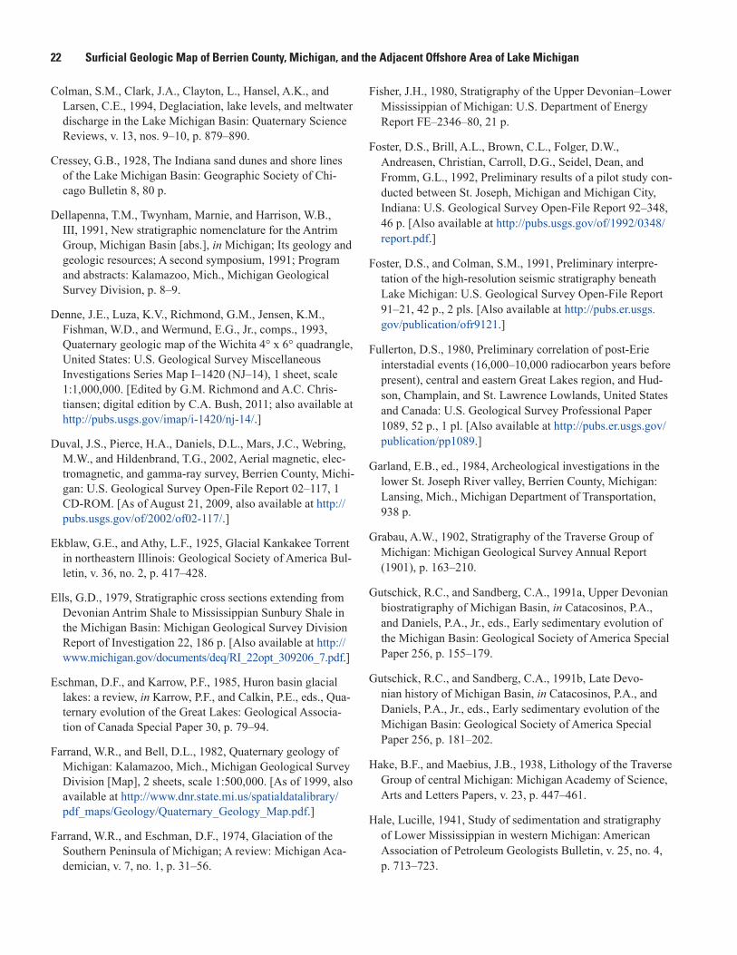
22 Surficial Geologic Map of Berrien County, Michigan, and the Adjacent Offshore Area of Lake Michigan
Colman, S.M., Clark, J.A., Clayton, L., Hansel, A.K., and Larsen, C.E., 1994, Deglaciation, lake levels, and meltwater discharge in the Lake Michigan Basin: Quaternary Science Reviews, v. 13, nos. 9–10, p. 879–890.
Cressey, G.B., 1928, The Indiana sand dunes and shore lines of the Lake Michigan Basin: Geographic Society of Chi-cago Bulletin 8, 80 p.
Dellapenna, T.M., Twynham, Marnie, and Harrison, W.B., III, 1991, New stratigraphic nomenclature for the Antrim Group, Michigan Basin [abs.], in Michigan; Its geology and geologic resources; A second symposium, 1991; Program and abstracts: Kalamazoo, Mich., Michigan Geological Survey Division, p. 8–9.
Denne, J.E., Luza, K.V., Richmond, G.M., Jensen, K.M., Fishman, W.D., and Wermund, E.G., Jr., comps., 1993, Quaternary geologic map of the Wichita 4° x 6° quadrangle, United States: U.S. Geological Survey Miscellaneous Investigations Series Map I–1420 (NJ–14), 1 sheet, scale 1:1,000,000. [Edited by G.M. Richmond and A.C. Chris-tiansen; digital edition by C.A. Bush, 2011; also available at http://pubs.usgs.gov/imap/i-1420/nj-14/.]
Duval, J.S., Pierce, H.A., Daniels, D.L., Mars, J.C., Webring, M.W., and Hildenbrand, T.G., 2002, Aerial magnetic, elec-tromagnetic, and gamma-ray survey, Berrien County, Michi-gan: U.S. Geological Survey Open-File Report 02–117, 1CD-ROM. [As of August 21, 2009, also available at http://pubs.usgs.gov/of/2002/of02-117/.]
Ekblaw, G.E., and Athy, L.F., 1925, Glacial Kankakee Torrent in northeastern Illinois: Geological Society of America Bul-letin, v. 36, no. 2, p. 417–428.
Ells, G.D., 1979, Stratigraphic cross sections extending from Devonian Antrim Shale to Mississippian Sunbury Shale in the Michigan Basin: Michigan Geological Survey Division Report of Investigation 22, 186 p. [Also available at http://www.michigan.gov/documents/deq/RI_22opt_309206_7.pdf.]
Eschman, D.F., and Karrow, P.F., 1985, Huron basin glacial lakes: a review, in Karrow, P.F., and Calkin, P.E., eds., Qua-ternary evolution of the Great Lakes: Geological Associa-tion of Canada Special Paper 30, p. 79‒94.
Farrand, W.R., and Bell, D.L., 1982, Quaternary geology of Michigan: Kalamazoo, Mich., Michigan Geological Survey Division [Map], 2 sheets, scale 1:500,000. [As of 1999, also available at http://www.dnr.state.mi.us/spatialdatalibrary/pdf_maps/Geology/Quaternary_Geology_Map.pdf.]
Farrand, W.R., and Eschman, D.F., 1974, Glaciation of the Southern Peninsula of Michigan; A review: Michigan Aca-demician, v. 7, no. 1, p. 31–56.
Fisher, J.H., 1980, Stratigraphy of the Upper Devonian–Lower Mississippian of Michigan: U.S. Department of Energy Report FE–2346–80, 21 p.
Foster, D.S., Brill, A.L., Brown, C.L., Folger, D.W., Andreasen, Christian, Carroll, D.G., Seidel, Dean, and Fromm, G.L., 1992, Preliminary results of a pilot study con-ducted between St. Joseph, Michigan and Michigan City, Indiana: U.S. Geological Survey Open-File Report 92–348, 46 p. [Also available at http://pubs.usgs.gov/of/1992/0348/report.pdf.]
Foster, D.S., and Colman, S.M., 1991, Preliminary interpre-tation of the high-resolution seismic stratigraphy beneath Lake Michigan: U.S. Geological Survey Open-File Report 91–21, 42 p., 2 pls. [Also available at http://pubs.er.usgs.gov/publication/ofr9121.]
Fullerton, D.S., 1980, Preliminary correlation of post-Erie interstadial events (16,000–10,000 radiocarbon years before present), central and eastern Great Lakes region, and Hud-son, Champlain, and St. Lawrence Lowlands, United States and Canada: U.S. Geological Survey Professional Paper 1089, 52 p., 1 pl. [Also available at http://pubs.er.usgs.gov/publication/pp1089.]
Garland, E.B., ed., 1984, Archeological investigations in the lower St. Joseph River valley, Berrien County, Michigan: Lansing, Mich., Michigan Department of Transportation, 938 p.
Grabau, A.W., 1902, Stratigraphy of the Traverse Group of Michigan: Michigan Geological Survey Annual Report (1901), p. 163–210.
Gutschick, R.C., and Sandberg, C.A., 1991a, Upper Devonian biostratigraphy of Michigan Basin, in Catacosinos, P.A., and Daniels, P.A., Jr., eds., Early sedimentary evolution of the Michigan Basin: Geological Society of America Special Paper 256, p. 155–179.
Gutschick, R.C., and Sandberg, C.A., 1991b, Late Devo-nian history of Michigan Basin, in Catacosinos, P.A., and Daniels, P.A., Jr., eds., Early sedimentary evolution of the Michigan Basin: Geological Society of America Special Paper 256, p. 181–202.
Hake, B.F., and Maebius, J.B., 1938, Lithology of the Traverse Group of central Michigan: Michigan Academy of Science, Arts and Letters Papers, v. 23, p. 447–461.
Hale, Lucille, 1941, Study of sedimentation and stratigraphy of Lower Mississippian in western Michigan: American Association of Petroleum Geologists Bulletin, v. 25, no. 4, p. 713–723.
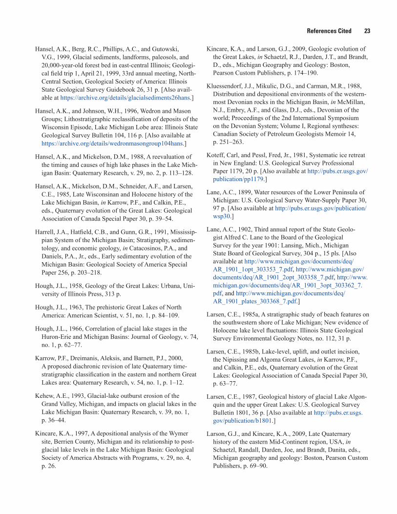
References Cited 23
Hansel, A.K., Berg, R.C., Phillips, A.C., and Gutowski, V.G., 1999, Glacial sediments, landforms, paleosols, and20,000-year-old forest bed in east-central Illinois; Geologi-cal field trip 1, April 21, 1999, 33rd annual meeting, North-Central Section, Geological Society of America: IllinoisState Geological Survey Guidebook 26, 31 p. [Also avail-able at https://archive.org/details/glacialsediments26hans.]
Hansel, A.K., and Johnson, W.H., 1996, Wedron and Mason Groups; Lithostratigraphic reclassification of deposits of the Wisconsin Episode, Lake Michigan Lobe area: Illinois State Geological Survey Bulletin 104, 116 p. [Also available at https://archive.org/details/wedronmasongroup104hans.]
Hansel, A.K., and Mickelson, D.M., 1988, A reevaluation of the timing and causes of high lake phases in the Lake Mich-igan Basin: Quaternary Research, v. 29, no. 2, p. 113–128.
Hansel, A.K., Mickelson, D.M., Schneider, A.F., and Larsen, C.E., 1985, Late Wisconsinan and Holocene history of theLake Michigan Basin, in Karrow, P.F., and Calkin, P.E.,eds., Quaternary evolution of the Great Lakes: GeologicalAssociation of Canada Special Paper 30, p. 39–54.
Harrell, J.A., Hatfield, C.B., and Gunn, G.R., 1991, Mississip-pian System of the Michigan Basin; Stratigraphy, sedimen-tology, and economic geology, in Catacosinos, P.A., and Daniels, P.A., Jr., eds., Early sedimentary evolution of the Michigan Basin: Geological Society of America Special Paper 256, p. 203–218.
Hough, J.L., 1958, Geology of the Great Lakes: Urbana, Uni-versity of Illinois Press, 313 p.
Hough, J.L., 1963, The prehistoric Great Lakes of North America: American Scientist, v. 51, no. 1, p. 84–109.
Hough, J.L., 1966, Correlation of glacial lake stages in the Huron-Erie and Michigan Basins: Journal of Geology, v. 74, no. 1, p. 62–77.
Karrow, P.F., Dreimanis, Aleksis, and Barnett, P.J., 2000, A proposed diachronic revision of late Quaternary time-stratigraphic classification in the eastern and northern Great Lakes area: Quaternary Research, v. 54, no. 1, p. 1–12.
Kehew, A.E., 1993, Glacial-lake outburst erosion of the Grand Valley, Michigan, and impacts on glacial lakes in the Lake Michigan Basin: Quaternary Research, v. 39, no. 1, p. 36–44.
Kincare, K.A., 1997, A depositional analysis of the Wymer site, Berrien County, Michigan and its relationship to post-glacial lake levels in the Lake Michigan Basin: Geological Society of America Abstracts with Programs, v. 29, no. 4, p. 26.
Kincare, K.A., and Larson, G.J., 2009, Geologic evolution of the Great Lakes, in Schaetzl, R.J., Darden, J.T., and Brandt, D., eds., Michigan Geography and Geology: Boston, Pearson Custom Publishers, p. 174‒190.
Kluessendorf, J.J., Mikulic, D.G., and Carman, M.R., 1988, Distribution and depositional environments of the western-most Devonian rocks in the Michigan Basin, in McMillan, N.J., Embry, A.F., and Glass, D.J., eds., Devonian of theworld; Proceedings of the 2nd International Symposiumon the Devonian System; Volume I, Regional syntheses:Canadian Society of Petroleum Geologists Memoir 14,p. 251–263.
Koteff, Carl, and Pessl, Fred, Jr., 1981, Systematic ice retreat in New England: U.S. Geological Survey Professional Paper 1179, 20 p. [Also available at http://pubs.er.usgs.gov/publication/pp1179.]
Lane, A.C., 1899, Water resources of the Lower Peninsula of Michigan: U.S. Geological Survey Water-Supply Paper 30, 97 p. [Also available at http://pubs.er.usgs.gov/publication/wsp30.]
Lane, A.C., 1902, Third annual report of the State Geolo-gist Alfred C. Lane to the Board of the Geological Survey for the year 1901: Lansing, Mich., Michigan State Board of Geological Survey, 304 p., 15 pls. [Also available at http://www.michigan.gov/documents/deq/AR_1901_1opt_303353_7.pdf, http://www.michigan.gov/documents/deq/AR_1901_2opt_303358_7.pdf, http://www.michigan.gov/documents/deq/AR_1901_3opt_303362_7.pdf, and http://www.michigan.gov/documents/deq/AR_1901_plates_303368_7.pdf.]
Larsen, C.E., 1985a, A stratigraphic study of beach features on the southwestern shore of Lake Michigan; New evidence of Holocene lake level fluctuations: Illinois State Geological Survey Environmental Geology Notes, no. 112, 31 p.
Larsen, C.E., 1985b, Lake-level, uplift, and outlet incision, the Nipissing and Algoma Great Lakes, in Karrow, P.F., and Calkin, P.E., eds, Quaternary evolution of the Great Lakes: Geological Association of Canada Special Paper 30, p. 63–77.
Larsen, C.E., 1987, Geological history of glacial Lake Algon-quin and the upper Great Lakes: U.S. Geological Survey Bulletin 1801, 36 p. [Also available at http://pubs.er.usgs.gov/publication/b1801.]
Larson, G.J., and Kincare, K.A., 2009, Late Quaternary history of the eastern Mid-Continent region, USA, in Schaetzl, Randall, Darden, Joe, and Brandt, Danita, eds., Michigan geography and geology: Boston, Pearson Custom Publishers, p. 69–90.
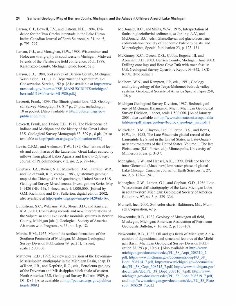
24 Surficial Geologic Map of Berrien County, Michigan, and the Adjacent Offshore Area of Lake Michigan
Larson, G.J., Lowell, T.V., and Ostrom, N.E., 1994, Evi-dence for the Two Creeks interstade in the Lake Huron basin: Canadian Journal of Earth Sciences, v. 31, no. 5, p. 793‒797.
Larson, G.J., and Monaghan, G.W., 1988, Wisconsinan and Holocene stratigraphy in southwestern Michigan: Midwest Friends of the Pleistocene field conference, 35th, 1988, Kalamazoo County, Michigan, guide book, 62 p.
Larson, J.D., 1980, Soil survey of Berrien County, Michigan: Washington, D.C., U.S. Department of Agriculture, Soil Conservation Service, 192 p. [Also available at http://www.nrcs.usda.gov/Internet/FSE_MANUSCRIPTS/michigan/berrienMI1980/berrienMI1980.pdf.]
Leverett, Frank, 1899, The Illinois glacial lobe: U.S. Geologi-cal Survey Monograph 38, 817 p., 24 pls., including pl. 18 in pocket. [Also available at http://pubs.er.usgs.gov/publication/m38.]
Leverett, Frank, and Taylor, F.B., 1915, The Pleistocene of lndiana and Michigan and the history of the Great Lakes: U.S. Geological Survey Monograph 53, 529 p., 8 pls. [Also available at http://pubs.er.usgs.gov/publication/m53.]
Lewis, C.F.M., and Anderson, T.W., 1989, Oscillations of lev-els and cool phases of the Laurentian Great Lakes caused by inflows from glacial Lakes Agassiz and Barlow-Ojibway: Journal of Paleolimnology, v. 2, no. 2, p. 99‒146.
Lineback, J.A., Bleuer, N.K., Mickelson, D.M., Farrand, W.R., and Goldthwait, R.P., comps., 1983, Quaternary geologic map of the Chicago 4° x 6° quadrangle, United States: U.S. Geological Survey Miscellaneous Investigations Series Map I–1420 (NK–16), 1 sheet, scale 1:1,000,000. [Edited by G.M. Richmond and D.S. Fullerton; digital edition 2002;also available at http://pubs.usgs.gov/imap/i-1420/nk-16/.]
Lundstrom, S.C., Williams, V.S., Stone, B.D., and Kincare, K.A., 2001, Contrasting records and new interpretations ofthe Valparaiso and Lake Border morainic systems in BerrienCounty, Michigan [abs.]: Geological Society of AmericaAbstracts with Programs, v. 33, no. 4, p. 18.
Martin, H.M., 1955, Map of the surface formations of the Southern Peninsula of Michigan: Michigan Geological Survey Division Publication 49 [part 1], 1 sheet, scale 1:500,000.
Matthews, R.D., 1993, Review and revision of the Devonian–Mississippian stratigraphy in the Michigan Basin, chap. D of Roen, J.B., and Kepferle, R.C., eds., Petroleum geology of the Devonian and Mississippian black shale of eastern North America: U.S. Geological Survey Bulletin 1909, p. D1–D85. [Also available at http://pubs.er.usgs.gov/publica-tion/b1909.]
McDonald, B.C., and Shilts, W.W., 1975, Interpretation of faults in glaciofluvial sediments, in Jopling, A.V., and McDonald, B.C., eds., Glaciofluvial and glaciolacustrine sedimentation: Society of Economic Paleontologists. and Mineralogists, Special Publication 23, p. 123‒131.
McKinney, K.C., Queen, D.G., Cobbs, Eugene, III, and Abraham, J.D., 2003, Berrien County, Michigan, June 2003; Drilling core logs and Bear Cave Tufa with trace fossils: U.S. Geological Survey Open-File Report 03–342, 1 CD-ROM. [Not online.]
Melhorn, W.N., and Kempton, J.P., eds., 1991, Geology and hydrogeology of the Teays-Mahomet bedrock valley systems: Geological Society of America Special Paper 258, 128 p.
Michigan Geological Survey Division, 1987, Bedrock geol-ogy of Michigan: Kalamazoo, Mich., Michigan Geological Survey Division, 1 sheet, scale 1:500,000. [As of January 2001, also available at http://www.dnr.state.mi.us/spatialda-talibrary/pdf_maps/geology/bedrock_geology_map.pdf.]
Mickelson, D.M., Clayton, Lee, Fullerton, D.S., and Borns, H.W., Jr., 1983, The Late Wisconsin glacial record of theLaurentide Ice Sheet in the United States, in Late-Quater-nary environments of the United States, Volume 1. The latePleistocene (S.C. Porter, ed.): Minneapolis, University ofMinnesota Press, p. 3–37.
Monaghan, G.W., and Hansel, A.K., 1990, Evidence for the intra-Glenwood (Mackinaw) low-water phase of glacial Lake Chicago: Canadian Journal of Earth Sciences, v. 27, no. 9, p. 1236–1241.
Monaghan, G.W., Larson, G.J., and Gephart, G.D., 1986, Late Wisconsinan drift stratigraphy of the Lake Michigan Lobe in southwestern Michigan: Geological Society of America Bulletin, v. 97, no. 3, p. 329–334.
Munsell, Inc., 2000, Soil color charts: Baltimore, Md., Mun-sell Corporation, 42 p.
Newcombe, R.B., 1932, Geology of Muskegon oil field, Muskegon, Michigan: American Association of Petroleum Geologists Bulletin, v. 16, no. 2, p. 153–168.
Newcombe, R.B., 1933, Oil and gas fields of Michigan; A dis-cussion of depositional and structural features of the Michi-gan Basin: Michigan Geological Survey Division Publi-cation 38, 293 p., 10 pls. [Also available at http://www.michigan.gov/documents/deq/PU_38_Aopt_308510_7.pdf, http://www.michigan.gov/documents/deq/PU_38_Bopt_308514_7.pdf, http://www.michigan.gov/documents/deq/PU_38_Copt_308515_7.pdf, http://www.michigan.gov/documents/deq/PU_38_Dopt_308516_7.pdf, http://www.michigan.gov/documents/deq/PU_38_Eopt_308519_7.pdf, and http://www.michigan.gov/documents/deq/PU_38_Plate-sopt_308520_7.pdf.]
References Cited 25
Newell, W.L., and Stone, B.D., 1997, U.S. Geological Survey 1997 surficial geologic mapping school (‘SURFSCHOOL’); Field mapping exercises in Berrien County, Michigan [abs.]: Geological Society of America Abstracts with Programs, v. 29, no. 6, p. A–39.
North American Commission on Stratigraphic Nomencla-ture, 1983, North American stratigraphic code: American Association of Petroleum Geologists Bulletin, v. 67, no. 5, p. 841–875.
Reed, J.C., Jr., Wheeler, J.O., and Tucholke, B.E., 2005, Geo-logic map of North America: Boulder, Colo., Geological Society of America, 3 sheets, scale 1:5,000,000. [Images of the map are also available at http://ngmdb.usgs.gov/gmna/.]
Richmond, G.M., and Fullerton, D.S., 1986, Introduction to Quaternary glaciations in the United States of America, in Sibrava, Vladimir, Bowen, D.Q., and Richmond, G.M., eds., Quaternary glaciations in the Northern Hemisphere: Quater-nary Science Reviews, v. 5, p. 3–10.
Rieck, R.L., and Winters, H.A., 1976, The bedrock surface and its relationship to hydrography and buried organic oxidized deposits: Michigan Academician, v. 9, no. 1, p. 97–108.
Riggs, C.H., 1938, Geology of Allegan County: Michi-gan Geological Survey Progress Report 4, 29 p. [Also available at http://www.michigan.gov/documents/deq/PR04opt_304702_7.pdf and http://www.michigan.gov/documents/deq/GIMDL-PR04b_216196_7.pdf.]
Roen, J.B., and Kepferle, R.C., eds., 1993, Petroleum geology of the Devonian and Mississippian black shale of eastern North America: U.S. Geological Survey Bulletin 1909–A–N, variously paged. [Also available at http://pubs.er.usgs.gov/publication/b1909.]
Russell, I.C., and Leverett, Frank, 1908, Description of the Ann Arbor quadrangle [Michigan]: U.S. Geological Survey Geologic Atlas, Folio 155, 15 p., 3 map sheets, scale 1:125,000. [Also available at http://pubs.er.usgs.gov/publication/gf155.]
Sandberg, C.A., Hasenmueller, N.R., and Rexroad, C.B., 1994, Conodont biochronology, biostratigraphy, and biofacies of Upper Devonian part of New Albany Shale, Indiana: Cou-rier Forschungsinstitut Senckenberg, v. 168, p. 227–253.
Schneider, A.F., 1983, Wisconsinan stratigraphy and glacial sequence in southeastern Wisconsin: Geoscience Wisconsin, v. 7, p. 59–85.
Schneider, A.F., and Hansel, A.K., 1990, Evidence for post-Two Creeks age of the type Calumet shoreline of glacial Lake Chicago, in Schneider, A.F., and Fraser, G.S., eds., Late Quaternary history of the Lake Michigan basin: Geo-logical Society of America Special Paper 251, p. 1‒8.
Schneider, A.F., and Need, E.A., 1985, Lake Milwaukee; An “early” proglacial lake in the Lake Michigan Basin, in Kar-row, P.F., and Calkin, P.E., eds., Quaternary evolution of the Great Lakes: Geological Association of Canada Special Paper 30, p. 55–62.
Sladen, J.A., and Wrigley, W., 1983, Geotechnical proper-ties of lodgement till; A review, in Eyles, N., ed., Glacial geology; An introduction for engineers and earth scientists: Oxford, U.K., Pergamon Press, p. 184–212.
Smith, R. A., 1912, The occurrence of oil and gas in Michi-gan: Michigan Geological and Biological Survey, Publica-tion 14, Geological Series 11, 281 p.
Stone, B.D., ed., 2001, Surficial geologic map of Berrien County, Michigan: U.S. Geological Survey Open-File Report 01–156, 1 sheet, scale 1:100,000. [Also available at http://pubs.usgs.gov/of/2001/ofr-01-0156/.]
Stone, B.D., 2006, 3-D stratigraphic and facies models of the glacial aquifer system of Berrien County, southwestern Michigan [abs.]: Geological Society of America Abstracts with Programs, v. 38, no. 7, p. 108.
Stone, B.D., Kincare, K.A., O’Leary, D.W., Lundstrom, S.C., Taylor, E.M., and Brown, S.E., 2003, Glacial and postgla-cial geology of the Berrien County region of Michigan: Midwest Friends of the Pleistocene Field Conference, 49th, 2003, Benton Harbor, Michigan, guide book, 70 p.
Stone, B.D., Kincare, Kevin, O’Leary, D.W., Newell, W.L, and Abraham, Jared, 2006, 3-D geologic map and digital database of Berrien County, southwestern Michigan [abs.]: Geological Society of America Abstracts with Programs, v. 38, no. 7, p. 164.
Stone, B.D., Stanford, S.D., and Witte, R.W., 2002, Surficial geologic map of northem New Jersey: U.S. Geological Survey Miscellaneous Investigations Series Map I–2540–C, 3 sheets, scale 1:100,000, and 41-p. pamphlet. [Also available at http://pubs.er.usgs.gov/publication/i2540C.]
26 Surficial Geologic Map of Berrien County, Michigan, and the Adjacent Offshore Area of Lake Michigan
Stone, B.D., Stone, J.R., Masterson, J.P., and O’Leary, D.W., 2004, Integrating 3-D facies analysis of glacial aquifer sys-tems with groundwater flow models; Examples from New England and the Great Lakes region, USA, in Berg, R.C., Russell, H.A.J., and Thorleifson, L.H., conveners, Three-dimensional geologic mapping for groundwater applica-tions; Workshop extended abstracts: Illinois State Geological Survey Open-File Series 2004–8, p. 89–95.
Stone, J.R., Schafer, J.P., London, E.H., DiGiacomo-Cohen, M.L., Lewis, R.S., and Thompson, W.B., 2005, Quaternarygeologic map of Connecticut and Long Island Sound Basin,with a section on Sedimentary facies and morphosequencesof glacial meltwater deposits, by B.D. Stone and J.R. Stone:U.S. Geological Survey Scientific Investigations Map 2784,2 sheets, scale 1:125,000, and 72-p. pamphlet. [Also avail-able at http://pubs.usgs.gov/sim/2005/2784/.]
Swezey, C.S., 2008, Regional stratigraphy and petroleum systems of the Michigan basin, North America: U.S. Geo-logical Survey Scientific Investigations Map 2978. [Also available at http://pubs.usgs.gov/sim/2978/.]
Tarbell, Eleanor, 1941, Antrim-Ellsworth-Coldwater Shale formations in Michigan: American Association of Petroleum Geologists Bulletin, v. 25, no. 4, p. 724–733.
Thornbury, W.D., 1965, Regional geomorphology of the United States: New York, John Wiley and Sons, Inc., 609 p.
Warthin, A.S., Jr., and Cooper, G.A., 1935, New formation names in the Michigan Devonian: Washington Academy of Sciences Journal, v. 25, no. 12, p. 524–526.
Warthin, A.S., Jr., and Cooper, G.A., 1943, Traverse rocks of Thunder Bay region, Michigan: American Association of Petroleum Geologists Bulletin, v. 27, no. 5, p. 571–595.
Wayne, W.J., 1963, Pleistocene formations in Indiana: Indiana Geological Survey Bulletin 25, 85 p.
Wentworth, C.K., 1922, A scale of grade and class terms for clastic sediments: Journal of Geology, v. 30, no. 5, p. 377–392.
Whitfield, J.W., Ward, R.A., Denne, J.E., Holbrook, D.F., Bush, W.V., Lineback, J.A., Luza, K.V., Jensen, K.M., and Fishman, W.D., comps., 1993, Quaternary geologic map of the Ozark Plateau 4° x 6° quadrangle, United States: U.S. Geological Survey Miscellaneous Investigations Series Map I–1420 (NJ–15), 1 sheet, scale 1:1,000,000. [Edited by G.M. Richmond and D.L. Weide; digital edition by C.A. Bush, 2012; also available at http://pubs.usgs.gov/imap/i-1420/nj-15/.]
Willman, H.B., and Frye, J.C., 1970, Pleistocene stratigraphy of lllinois: Illinois State Geological Survey Bulletin 94, 204 p.
Winchell, Alexander, 1861, First biennial report of the prog-ress of the geological survey of Michigan, embracing obser-vations on the geology, zoölogy and botany of the Lower Peninsula: Lansing, Mich., Michigan Geological Survey, 339 p. [Also available at http://www.biodiversitylibrary.org/bibliography/54685#/summary.]
Winchell, N.H., 1874, The second annual report, for the year 1873: St. Paul, Minn., Minnesota Geological and Natural History Survey, p. 138–147.
Winkler, E.M., and VanBesien, A.C., 1963, Bear Cave, a tufa cave in glacial drift near Buchanan, Michigan: National Speleological Society Bulletin, v. 25, pt. 2, p. 79–82.
Winters, H.A., and Rieck, R.L., 1982, Drainage reversals and transverse relationships of rivers to moraines in southern Michigan: Physical Geography, v. 3, no. 1, p. 70–82.
Wold, R.J., Paull, R.A., Wolosin, C.A., and Friedel, R.J., 1981, Geology of central Lake Michigan: American Association of Petroleum Geologists Bulletin, v. 65, no. 9, p. 1621–1632.
Description of Surface and Subsurface Map Units 27
Description of Surface and Subsurface Map Units Map units include unconsolidated and locally cemented Quaternary surficial materials >1 m (>3.3 ft) thick, and bedrock
units. Surficial sediment types and gravel-clast rock types are listed in decreasing order of abundance; color designations, in parentheses (Munsell, Inc., 2000), are based on naturally moist samples. A veneer of eolian silt, mixed with small amounts of fine sand, clay, and scattered gravel particles, ranging in thickness from a few centimeters (cm) to 4 m (13.1 ft), covers upland hills and plains; this veneer is not mapped. A discontinuous veneer of eolian fine sand, <1 to 3 m (<3.3‒10 ft) thick is present locally, but is not mapped. Sandy colluvium <1 m (<3.3 ft) thick covers most erosional slopes and is not mapped. Soil descrip-tions are modified from Larson (1980). Subdivision of Quaternary time is based on Richmond and Fullerton (1986).
Quaternary
Holocene
af Artificial fill (late Holocene)—Earth and manmade materials that have been artificially emplaced, including gravel, sand, silt, clay, compacted select earth materials, garbage, trash, and bulky waste; 1.8 to 15 m (6‒50 ft) thick. Fill is not shown where it is <1.8 m (˂6 ft) thick in urban areas, and beneath most highway and railroad beds
Qmb Lake Michigan beach deposits (late Holocene)—Very pale brown (10YR 7‒8/4) to light-gray (10YR 7/2) fine to very coarse sand with minor gravel, moderately sorted; local cobble gravel with fine to coarse sand matrix; deposited on modern beaches; 1 to 3 m (3.3‒10 ft) thick. Deposits are correlated lithostratigraphically with the informal Dolton facies unit (foreshore lacustrine sand and gravel) of the Henry Formation of Illinois (Hansel and Johnson, 1996), revised from Willman and Frye (1970)
Qmn Lake Michigan nearshore deposits (late Holocene)—Very pale brown (10YR 7‒8/4) to light-gray (10YR 7/2) fine to very coarse sand with minor gravel, moderately sorted; local cobble gravel with fine to coarse sand matrix; deposited in submerged beach face, offshore bars, and shallow offshore areas; 1 to 6 m (3.3‒20 ft) thick; deposits are thin and patchy in deeper offshore areas. Deposits are correlated lithostratigraphically with the informal Dolton facies unit (nearshore lacustrine sand and gravel) of the Henry Formation of Illinois (Hansel and Johnson, 1996), revised from Willman and Frye (1970)
Qed Active eolian dune sand (late Holocene)—Very pale brown (10YR 7‒8/4) to light-gray (10YR 7/2) fine to medium sand, massive or in concave or planar crossbeds in planar-tabular sets; in active coastal dunes; 1 to 8 m (3.3‒26.2 ft) thick
Qmls Lake Michigan lake-bottom sand deposits (late Holocene)—Light-gray to gray (10YR 7/2) to gray (10YR 6/1) fine to very fine sand, loose; deposited in shallow offshore areas; thickens to approximately 8 m (26 ft) and becomes finer offshore. Deposits are correlated lithostratigraphically with the informal Dolton facies unit (nearshore lacustrine sand and gravel) of the Henry Formation of Illinois (Hansel and Johnson, 1996), revised from Willman and Frye (1970)
Qmlm Lake Michigan lake-bottom mud deposits (late Holocene)—Light-gray to gray (10YR 7/2) to gray (10YR 6/1) silt and muddy sand, nonplastic or loose, containing variable trace amounts of organic materials; deposited in deep offshore areas; thickens to approximately 10 m (33 ft) and becomes finer offshore. Deposits are correlated lithostratigraphically with the Lake Michigan Member of the Equality Formation of Illinois (Hansel and Johnson, 1996), revised from the upper Lake Michigan Formation of Foster and Colman (1991) and Willman and Frye (1970)
Qal Alluvium (late to early Holocene)—Grayish-brown (10YR 5/2) to pale-brown (10YR 6/3) sand, gravel, silt, minor clay, and some organic material; deposited by modern streams. In flood plains of major rivers, alluvium consists of poorly sorted gravel and sand at the base, overlain by laminated and thinly bedded sand, silt, and clay; thickness 1.8 to 9.1 m (6‒30 ft); in lower St. Joseph River flood plain, unit is >24 m (>80 ft) thick; lower parts of these deposits extend offshore in channels eroded during the Lake Chippewa low-phase
28 Surficial Geologic Map of Berrien County, Michigan, and the Adjacent Offshore Area of Lake Michigan
lake level (70 m (230 ft) altitude; Hough, 1958; Larsen, 1987) in the Lake Michigan basin; upper alluvial deposits in the near-coastal valleys of major streams are graded to the present level of Lake Michigan (176.8 m (580 ft)). Along smaller streams, alluvium is composed of poorly sorted sand and gravel derived from adjacent glacial, meltwater, and colluvial materials; thickness generally <4 m (˂13.1 ft). Deposits are correlated lithostratigraphically with the Cahokia Formation of Illinois (Hansel and Johnson, 1996), revised from Willman and Frye (1970)
Qaf Alluvial fan deposits (middle to early Holocene)—Very pale brown (10YR 7‒8/4) sand, gravel, silt, minor clay, and some organic material deposited at the mouths of modern streams on flood-plain alluvium; thickness generally <3 m (˂10 ft)
Qnb Beach deposits, Nipissing lake phase (middle Holocene)—Brown to very pale brown (10YR 5/3‒7/4) fine to very coarse sand with minor gravel (locally cobble gravel with fine to coarse sand matrix) in beaches, spits, and bars of postglacial Nipissing lake phase in the Lake Michigan basin; highest upper surface of deposits is 185 m (607 ft) altitude; 1 to 3 m (3.3‒10 ft) thick
Holocene and Late WisconsinanQst Stream terrace deposits (middle Holocene to late Wisconsinan)—Very pale brown (10YR 7‒8/4) to
yellow (10 YR 7/6) sand, pebble gravel, and minor silt; deposited by streams having discharge regimes greater than the present streams and graded to fluvial base levels higher than modern levels. Surface altitudes of terrace segments lower downstream from 212 m to 187 m (695‒614 ft). Rivers related to some of these deposits were graded to lowering lake levels in the Lake Michigan basin following the Calumet phase (189 m (620 ft) altitude) of glacial Lake Chicago. Other, younger rivers transported deposits to the Nipissing lake phase (184 m (604 ft)) (Leverett and Taylor, 1915; Hough, 1966; Hansel and Mickelson, 1988), and subsequent falling stream levels transported deposits to the present phase of Lake Michigan. Unit is 1 to 8 m (3.3‒26.2 ft) thick
Qsd Eolian dune sand deposits (middle Holocene to late Wisconsinan)—Very pale brown (10YR 7‒8/4) to yellow (10YR 7/6) fine to medium sand, massive or in planar or concave crossbeds in planar-tabular sets; in inland dunes and in dunes related to glacial and postglacial lake phases in the Lake Michigan basin; unit includes deposits related to the Glenwood, Calumet, and Toleston phases of glacial Lake Chicago, glacial Lake Algonquin, and the Nipissing lake phase; typically 1 to 15 m (3.3‒49.2 ft) thick though may reach thicknesses up to 55 m (180 ft)
Qes Eolian sand sheet deposits (middle Holocene to late Wisconsinan)—Very pale brown (10YR 7‒8/4) to yellow (10YR 7/6) fine to medium sand, massive, commonly 2 to 3 m (6.5‒10 ft) thick. Not mapped where ˂1 m (<3 ft) thick
Qsm Swamp and marsh deposits (late Holocene to late Wisconsinan)—Black to dark-reddish-brown (5YR 2.5/1‒3/3) to gray (10YR 5‒6/1) peat and muck interbedded with and overlying laminated silt, clay, and minor sand and gravel; peat is decomposed, fibrous or granular, woody or herbaceous; muck is organic, clayey or sandy silt; thickness, including basal silt and clay, generally less than 5.5 m (l8 ft)
Qc Colluvium deposits (middle Holocene to late Wisconsinan)—Very pale brown (10YR 7‒8/4) to yellow (10YR 7/6) silty sand or sandy silt deposits, consisting of a poorly sorted matrix of sand and silt containing 5 to 20 percent (by volume) pebbles; commonly massive to indistinctly layered; locally stratified, laterally extensive; 1 to 4 m (3.3‒13.1 ft) thick
Late WisconsinanQccb Beach deposits, glacial Lake Chicago, Calumet phase (late Wisconsinan)—Brown to very pale brown
(10YR5/3‒7/4) fine to very coarse sand with minor gravel (locally cobble gravel with fine to coarse sand matrix) in beaches, spits, and bars; highest surface of deposits is 190 m (623 ft) altitude; 1 to 3 m (3.3‒10 ft) thick
Description of Surface and Subsurface Map Units 29
Late Wisconsinan Glacial Meltwater Deposits
Grayish-brown to brown (10YR 5/2‒5/3) to dark-yellowish-brown (10YR 4/4) sand and gravel, and light-brownish-gray (10YR 6/2) to very pale brown to light-yellowish-brown (10YR 7/4‒6/4) gravelly sand, fine sand, and silty sand (fig. 1, this pam-phlet); stratified, poorly to moderately sorted, and generally calcareous; and light-brownish-gray (10YR 6/2) silt and gray (5Y 5/1) clay, stratified, moderately sorted. Gravel is polymict, composed of granitic gneiss, sandstone, granite, quartzite, conglomer-ate, limestone, dolostone, and shale; gravel clasts are subrounded to well rounded, generally nonweathered; some coarse gravel clasts are striated. Sand composition is highly variable, from lithic coarse sand to sublithic fine sand; grains generally are non-weathered. The glacial meltwater deposits are divided into two groups of map units based on their sedimentary facies: glacial-stream deposits and glacial-lake deposits. Deposits of glacial-stream units contain two sedimentary facies, consisting of sand and gravel, and pebbly sand. Deposits of glacial-lake units contain ice-channel, deltaic, and lake-bottom deposits. Ice-channel deposits contain coarse gravel, commonly with interbedded flowtill deposits, and interbedded sand and gravel in the subsurface. Deltaic deposits consist of sand and gravel facies in delta topset sediments, sand and gravel to fine sand delta foreset facies, and fine sand to silty sand delta bottomset facies in the subsurface. Sand and gravel glaciolacustrine fan facies locally may underlie some deltaic deposits. Fine sand and silt-clay lake-bottom facies underlie distal delta deposits and lake-bottom plains.
Stratified meltwater deposits are subdivided into map units on the basis of the distribution, stratigraphic relationships, and altitudes of sedimentary facies in different depositional basins that were present along the melting margin of the ice sheet. Map units show the extent of sediments in each glacial-stream deposit or sediments deposited in or graded to each glacial lake. Each map unit contains one or more ice-marginal or near-ice-marginal meltwater deposits, known as morphosequences (Koteff and Pessl, 1981). Each morphosequence typically consists of a progression of landforms and sedimentary facies, grading from ice-contact landforms underlain by coarse-grained facies at the head of the deposit to depositional, noncollapsed landforms under-lain by finer grained facies in distal parts of the deposit. The heads of ice-marginal deposits are coarse grained, locally contain-ing boulders and lenses of poorly sorted flowtill sediments, and they characteristically have a zone of collapsed and deformed bedding along ice-contact slopes. Glaciofluvial deposits at the surface of each morphosequence are graded to a specific base level, which was controlled by the altitudes of various glacial lakes that covered parts of Berrien County.
Soils associated with upland glacial meltwater deposits generally are alfisols developed either entirely in overlying eolian sandy silt deposits, or in sandy silt that overlies sand and gravel deposits in the soil C horizon. On slopes and meltwater terrace deposits the alfisols are in sandy silt overlying sand and gravel. The alfisols have well-developed argillic B horizons, 0.6 to ˃1.5 m (25‒˃60 inches [in.]) thick, overlying C horizons in lightly oxidized, calcareous sand and gravel sediments. Soils associated with lake-bottom deposits are mollisols commonly developed in eolian silty sand deposits that overlie fine sand, silt, and clay deposits in the soil C horizon. Mollisols have gleyed argillic B horizons, 0.2 to 0.6 m (10‒26 in.) thick, overlying nonoxidized sand, silt, or clay sediments.
Deposits of Glacial Streams
Interbedded sand and gravel, moderately to poorly sorted, horizontally stratified. Deposits grade downstream from (1) sand and gravel facies to (2) pebbly coarse sand facies in distal parts of some units. The sand and gravel facies is most prevalent; it consists of pebble- and cobble-gravel beds interbedded with beds of medium to coarse sand. Cobble-gravel beds are massive or planar bedded, poorly to moderately sorted, and have local imbrication of clasts; pebble- or cobble-gravel beds also contain planar/tabular and trough crossbeds. Gravel beds are 0.2 to 1.5 m (0.7‒5 ft) thick. Sand beds are chiefly coarse sand with pebbles and granules, poorly sorted, in trough and planar/tabular crossbeds. Medium- and fine-sand ripple cross-laminated beds are minor constituents. The pebbly coarse sand facies consists chiefly of coarse sand with pebbles in trough and planar/tabular cross-beds, and in planar beds. Thin beds of pebble gravel are minor constituents. Map overprint patterns show the distribution of the two facies in the glacial-stream deposits of Berrien County.
Map units in Berrien County containing only glacial-stream deposits originated as valley-train outwash deposits, which are preserved in valleys as eroded terrace deposits that extend to ice-marginal heads of outwash east of the county. The valley-train terrace deposits have smooth downstream surface profiles, and the deposits overlie older glacial-lake deposits (sections A–A′ and B–B′, sheet 1). Deposits are correlated lithostratigraphically with the valley outwash deposits of the Henry Formation of Illinois (Hansel and Johnson, 1996), revised from Willman and Frye (1970).
Qccp Paw Paw fluvial terrace deposits, Calumet phase, glacial Lake Chicago—Grayish-brown to dark-yellowish-brown, very pale brown to light-yellowish-brown pebble gravel and sand grading downstream to coarse sand; surface altitudes of terrace slope from 201 m to 191 m (660‒625 ft); relict braided channels engrave the surface. Unit is 3.7 to 12.2 m (12‒40 ft) thick; graded to the Calumet phase (189 m (620 ft) altitude) of glacial Lake Chicago (Leverett and Taylor, 1915; Hough, 1966; Hansel and Mickelson, 1988)
30 Surficial Geologic Map of Berrien County, Michigan, and the Adjacent Offshore Area of Lake Michigan
Qccj St. Joseph and Galien fluvial terrace deposits, Calumet phase, glacial Lake Chicago—Grayish-brown to dark-yellowish-brown, very pale brown to light-yellowish-brown pebble-cobble gravel, pebble gravel, and sand grading downstream to coarse sand; surface altitudes of terrace slope from 204 m to 191 m (670‒625 ft); relict braided channels locally engrave the surface. Unit is 3.7 to 12.2 m (12‒40 ft) thick; graded to the Calumet phase (189 m (620 ft) altitude) of glacial Lake Chicago (Leverett and Taylor, 1915; Hough, 1966; Hansel and Mickelson, 1988)
Qcgp Paw Paw meltwater terrace deposits, Glenwood phase, glacial Lake Chicago—Grayish-brown to dark-yellowish-brown, very pale brown to light-yellowish-brown pebble gravel and sand; surface altitudes of erosional terrace remnants slope from 201 m to 195 m (660 ft‒640 ft). Unit is 3.7 to 12.2 m (12‒40 ft) thick; graded to the Glenwood phase (195 m (640 ft) altitude) of glacial Lake Chicago (Leverett and Taylor, 1915; Farrand and Eschman, 1974)
Qcgj St. Joseph meltwater terrace deposits, Glenwood phase, glacial Lake Chicago—Grayish-brown to dark-yellowish-brown, very pale brown to light-yellowish-brown pebble-cobble gravel, pebble gravel, and sand grading downstream to coarse sand; surface altitudes of terrace slope from 204 m to 195 m (670‒640 ft); relict braided channels locally engrave the surface. Unit is 3.7 to 12.2 m (12‒40 ft) thick; graded to the Glenwood phase (195 m (640 ft) altitude) of glacial Lake Chicago (Leverett and Taylor, 1915; Farrand and Eschman, 1974)
Qsk St. Joseph-Kankakee meltwater terrace deposits—Grayish-brown to dark-yellowish-brown, very pale brown to light-yellowish-brown pebble-cobble gravel and sand grading downstream to coarse sand; surface altitudes of terrace segments slope from 223 m to 219 m (730‒720 ft); locally collapsed; 3.7 to 9.1 m (12‒30 ft) thick; projected terrace surfaces are graded to outwash terrace surfaces in the Kankakee River valley, Indiana (S.E. Brown, Indiana Geological Survey, oral commun., 2003; Stone and others, 2003)
Deposits of Glacial Lakes
Sand, sand and gravel, and silty sand in deltaic, ice-channel, and glaciolacustrine fan deposits; and fine sand, silt, and clay in lake-bottom deposits (cross sections, sheet 1). Deltaic deposits have glacial-stream topset beds, 0.6 to 18.3 m (2‒60 ft) thick, composed of (1) coarse gravel facies, (2) sand and gravel facies, and (3) pebbly sand facies. The coarse gravel facies consists of massive cobble-gravel beds that have a poorly sorted sand matrix; beds of small boulders are common. Coarse gravel beds generally are less than 1 m (3.3 ft) thick; beds composed of finer grained sediment are rare. Map overprint patterns show the dis-tribution of the three glacial-stream topset facies that overlie deltaic foreset and bottomset facies in each delta deposit. Delta foreset facies include (1) sand and gravel foreset facies, consisting of gravel, pebbly sand, and coarse sand, poorly to moderately sorted, in 2.0- to 10.1-m (6.5‒33-ft)- thick sets of thin foreset beds that dip 25o to 35o; and (2) sandy foreset facies, consisting of fine to medium sand, moderately sorted, in interbedded parallel-laminated and ripple cross-laminated sets of beds that are 2.0 to 5.2 m (6.5–17 ft) thick and that dip less than 25o; draped laminations of silt and clay are common in lower beds. Delta bottomset facies are (1) the sand and gravel bottomset facies, consisting of coarse pebbly sand in planar-tabular crossbeds and parallel-bedded fine sand, silt, and clay, in sets of beds that dip less than 5o; and (2) the sandy bottomset facies, consisting of fine sand, silt, and minor clay, in ripple cross-laminated and parallel-laminated beds that dip less than 5o. The total thickness of deltaic sediments is approximately 6.1 to 45.7 m (20‒150 ft). Ice-marginal deltas in Berrien County contain sand and gravel and sandy foresets, including beds of silty flowtill, and thick sandy bottomset facies. Glaciolacustrine fans contain sand and gravel and sandy fore-set and bottomset facies, and minor till, flowtill, and fine-grained lake-bottom sediments; fans underlie some deltaic deposits. Lake-bottom deposits contain a sandy facies and a silt-clay facies, which are shown by map overprint patterns. The sandy facies consists of fine sand to silt in parallel-laminated and minor ripple cross-laminated sets of beds. The silt-clay facies consists of silt-to-very fine sand, and clay in parallel laminations, microlaminations, and minor ripple cross-laminations; deposits with laminations of variable thickness have clay laminae <2 millimeters (mm) (˂0.08 in.) thick; varve deposits of this facies consist of couplets of microlaminated silt-to-very fine sand, and massive or graded clay; couplets typically are 0.4 to 10 cm (0.2‒4 in.) thick; vertical sequences of varves show little variation in couplet thickness. Deltaic and ice-contact deposits are correlated lithostratigraphically with similar deposits of the Henry Formation of Illinois (Hansel and Johnson, 1996), revised from Willman and Frye (1970). Lake-bottom deposits are correlated lithostratigraphically with the fine-grained glaciolacustrine deposits of the Henry Formation of Illinois (Hansel and Johnson, 1996), revised from Willman and Frye (1970).
Qcg Lake littoral deposits, Glenwood phase, glacial Lake Chicago—Pale-brown fine sand at the surface locally, moderately sorted, crossbedded and laminated; minor coarse pebbly sand; thin cobble gravel at base.
Description of Surface and Subsurface Map Units 31
Highest surface of unit is 188 m (617 ft) altitude. Unit is 1 to 20 m (3‒65 ft) thick and was deposited in shallow-water, nearshore, and beach lake environments
Qcgl Lake-bottom deposits, Glenwood phase, glacial Lake Chicago—Pale-brown fine sand at the surface locally, moderately sorted, laminated; and gray silt and clay, laminated; highest surface of lake-bottom plain is 194 m (636 ft) altitude. Unit is 0.9 to 9.1 m (3‒30 ft) thick and was deposited in shallow-water and nearshore lake environments
Deposits of Glacial Lake Baroda of the Lake Border Morainic SystemLake-bottom deposits consisting of fine sand, silt, and clay (drill holes USGS TO, NB); littoral deposits composed of
pebble gravel and sand; and ice-marginal glaciodeltaic deposits consisting of sand and gravel topset beds overlying gravel and sandy foreset beds; all reportedly totaling as much as 21.3 m (70 ft) thick. The dam for this large ice-marginal lake was older deltaic deposits of glacial Lake Dowagiac and other deposits of the Valparaiso morainic system in northern Indiana. The lake extended northward and westward as the ice margin retreated. Units include deposits related to lowering phases of the lake, which were controlled by lake spillway channels cut in older deposits in Indiana at altitudes descending from about 219 m to 201 m (720‒660 ft). Lake Baroda lowered to the Glenwood phase of glacial Lake Chicago following retreat of the ice margin from northern Indiana. Deposits of glacial Lake Baroda are correlated with the Lake Border morainic system (Leverett, 1899; Leverett and Taylor, 1915; Farrand and Bell, 1982; Lineback and others, 1983; Stone, 2001; Stone and others, 2003).
Qblu Upper lake-bottom deposits, glacial Lake Baroda—Pale-brown fine sand at the surface locally, moderately sorted, laminated; and gray silt and clay, laminated; surface of lake-bottom plains is at 207 to 201 m (680‒660 ft) altitude. Unit is as much as 20 m (65 ft) thick and was deposited in shallow-water and nearshore lake environments
Qbbb Littoral deposits, glacial Lake Baroda—Pale-brown fine to very coarse sand, pebble gravel, and minor silt and clay; coarse-grained deposits are moderately sorted, planar bedded, and crossbedded; fine-grained deposits are laminated; surface of beach berms is 216 to 201 m (710‒660 ft) altitude. Unit is 1 to 6 m (3.3‒20 ft) thick and was deposited in beaches, locally below shoreline cliffs, and in offshore bars and deltas in shoreline lake environments
Qblm Middle lake-bottom and deltaic deposits, glacial Lake Baroda—Pale-brown fine sandy lake-bottom deposits, moderately sorted, ripple cross-laminated and laminated; and gray fine sand, silt, and clay, laminated, in distal deposits. Deltaic foreset deposits exposed in lake bluffs at Mizpah Park consist of pebbly sand and sandy forest facies, >30.5 m (>100 ft) thick (section A–A′, sheet 1); and sandy delta bottomset deposits exposed in lake bluffs at Shoreham consist of fine sand, silt, and minor clay, in ripple cross-laminated and parallel-laminated beds. Local depositional basins extend from 9 km (5.6 mi) offshore from the northwestern corner of the map area to south of Bridgman, and from east of Harbert to south and offshore of Michiana (section B–B′, sheet 1; fig. 13, sheet 2); the surfaces of deposits in the offshore submerged basins are as low as 60 m (196 ft) altitude. Unit is as much as 100 m (328 ft) thick north of Mizpah Park, and 66 m (216 ft) thick in the distal basin beneath New Buffalo
Qbll Lower lake-bottom deposits, glacial Lake Baroda (subsurface unit)—Pale-brown fine sand, moderately sorted, laminated; and gray silt and clay, laminated; local depositional basins extend from northwest of Coloma to south of New Troy, and from northeast of Three Oaks to south of New Buffalo (sections B–B′ and C–C ′, sheet 1; fig. 12, sheet 2); surface of deposit is at 110 to 185 m (360‒607 ft) altitude. Unit is as much as 75 m (246 ft) thick and was deposited in deepwater and distal lake environments
Qbg Galien ice-marginal deltaic deposits, glacial Lake Baroda—Multiple deposits, undifferentiated, but including four collapsed and eroded ice-marginal deltas, and smaller ice-channel ridges and local sand and gravel, and lake-bottom sand deposits. Surface altitudes of glaciofluvial plains range from 215 m to 220 m (705‒722 ft); deltaic deposits contain local thin till and flowtill deposits. Unit is 2 to 25 m (6.5‒82 ft) thick; the local depositional basin extended along the ice margin from Glendora to the area south of Avery
Qbb La Boyer ice-marginal deltaic deposits, glacial Lake Baroda—Sand and gravel grading to pebble gravel and coarse sand, overlying sand, silt, and clay in subsurface; deposits include glaciotectonic thrust faults and recumbent folds in a transverse ridge as high as 232 m (760 ft) at head of the deposit; surface altitudes of the glaciofluvial plain slope from 222.5 m to 213 m (730‒700 ft). Unit is as much as 70 m (230 ft) thick
32 Surficial Geologic Map of Berrien County, Michigan, and the Adjacent Offshore Area of Lake Michigan
Ice-Marginal Deltaic Deposits of the Valparaiso Morainic System
Ice-marginal glaciodeltaic deposits consisting of sand and gravel topset beds overlying dipping gravel and sandy foreset beds and thick sandy and silty bottomset and lake-bottom beds, and ice-channel deposits. These deposits accumulated in local lake basins that contained water at altitudes higher than glacial Lake Dowagiac. The dams for two of these ice-marginal lakes (units Qhd, Qec) were older meltwater deposits and surrounding walls of stagnant glacial ice; the dam for the large undifferenti-ated deposit (unit Qcr) was older deposits of the inner Kalamazoo moraine on the southeastern side of the basin, including Keeler ice-channel and ice-marginal deltaic deposits (unit Qikk). All of these deposits along the eastern side of the glacial Lake Dowa-giac basin are correlated with the Valparaiso morainic system (Leverett, 1899; Leverett and Taylor, 1915; Farrand and Bell, 1982; Lineback and others, 1983; Stone, 2001; Stone and others, 2003).
Qhd Hennesy ice-hole deltaic deposits—One large ice-hole glaciodeltaic deposit; surface altitudes of the glaciofluvial plain range from 238 m to 234.7 m (780‒770 ft); deltaic deposits overlie sand, silt, and clay lake-bottom deposits in the subsurface (drill hole USGS W). Deposits are inferred to extend 5 km (3.1 mi) to the northeast in the subsurface, where they fill a depression on underlying beds and the bedrock surface. Unit is as much as 75 m (246 ft) thick. The local depositional basin extended from south of Watervliet to the northeastern side of Paw Paw Lake. The dam for this ice-marginal lake consisted of surrounding walls of stagnant glacial ice
Qcr Carmody ice-marginal deltaic deposits—Multiple deposits, undifferentiated, but including at least two large ice-marginal deltas and ice-channel deposits; surface altitudes of glaciofluvial plains slope from 247 m to 232 m (810‒760 ft). Deltaic deposits overlie sandy lake-bottom deposits in the subsurface; unit is as much as 135 m (443 ft) thick. The dam for this local ice-marginal lake was older deposits of the inner Kalamazoo moraine on the southeastern side of the lake basin. The local depositional basin developed within a large melted reentrant in the ice margin that extended from 2 km (1.2 mi) south of Coloma to Bainbridge Center and eastward to the lake dam in Cass County. This local lake lowered to the level of glacial Lake Dowagiac following ice margin recession from western Cass County
Qec Eau Claire ice-marginal deltaic deposits—Multiple deposits, undifferentiated, but including at least one large and three small ice-marginal deltas and ice-channel deposits; surface altitudes of glaciofluvial plains slope from 244 m or 238 m to 232 m (800 ft or 780 ft to 760 ft). Deltaic deposits overlie sandy lake-bottom deposits in the subsurface (drill holes USGS D, H); unit is as much as 88 m (289 ft) thick. The dam for this local ice-marginal lake was older deltaic deposits of units Qdb, Qdf, and Qikk on the southeastern side of the lake basin. The local depositional basin developed along the ice margin from Berrien Springs and Eau Claire to 3 km (1.9 mi) east of Naomi. This local lake lowered to the level of glacial Lake Dowagiac following ice margin recession from the ice-contact head of the deposit
Deposits of Glacial Lake Dowagiac of the Valparaiso Morainic System
Ice-marginal and near-ice-marginal glaciodeltaic deposits consisting of sand and gravel topset beds overlying dipping gravel and sandy foreset beds and thick sandy and silty bottomset and lake-bottom beds. The dam for this large ice-marginal lake was older deposits of the inner Kalamazoo moraine on the southeastern side of the lake basin, including Portage Prairie deposits (unit Qikp). The lake expanded northward and westward as the ice margin retreated; the open water of the lake extended through successively collapsed deposits to the lake spillway, which was a channel cut in older deposits (unit Qikp) at about 225.6 m (740 ft) altitude. Glacial Lake Dowagiac lowered to the high level of glacial Lake Baroda following retreat of the ice margin from the western limit of the lake. Units include surface sandy lake-bottom deposits of glacial Lake Dowagiac of Russell and Leverett (1908). Deposits of glacial Lake Dowagiac are correlated with the Valparaiso morainic system (Leverett, 1899; Leverett and Taylor, 1915; Farrand and Bell, 1982; Lineback and others, 1983; Stone, 2001; Stone and others, 2003).
Qdlu Upper lake-bottom deposits, glacial Lake Dowagiac—Pale-brown fine sand at the surface locally, moderately sorted, laminated; and gray silt and clay, laminated; surface of lake-bottom plains is 219 m to 210 m (720‒690 ft) altitude; local subsurface basin extends from Benton Heights-Benton Center to Sodus village, and from Hollywood to south of Three Oaks. Unit is as much as 98 m (321 ft) thick and was deposited in deep to shallow ice-marginal lake environments
Description of Surface and Subsurface Map Units 33
Qdc Coloma ice-marginal deltaic deposits, glacial Lake Dowagiac—Two small, adjacent ice-marginal deltas; surface altitudes of glaciofluvial plains slope from 227 m to 223 m (745‒732 ft); deltaic deposits overlie sandy lake-bottom deposits (unit Qdlu). The local depositional basin extended along the ice margin from southwest of the Coloma area to Benton Heights-Benton Center; unit is as much as 78 m (256 ft) thick
Qdbn Bainbridge ice-marginal deltaic deposits, glacial Lake Dowagiac—Multiple deposits, undifferentiated, but including four small ice-marginal deltas; surface altitudes of glaciofluvial plains slope from 244 m to 224 m (800‒735 ft); deltaic deposits overlie silty lake-bottom deposits (unit Qdlu). The local depositional basin extended along the ice margin from the Pipestone Creek area to 3 km south of Coloma; unit is as much as 123 m (403 ft) thick
Qdbi Biastock ice-marginal deltaic deposits, glacial Lake Dowagiac—Multiple deposits, undifferentiated, but including one large ice-marginal delta and two narrow ice-marginal deltas; surface altitudes of glaciofluvial plains slope from 244 m to 224 m (800‒735 ft); deltaic deposits overlie sandy lake-bottom deposits in the subsurface, and grade down delta frontal slopes to lake-bottom plains (unit Qdlu). The local depositional basin extended along the ice margin from the Pipestone Creek area to Bainbridge Center. Unit is as much as 112 m (367 ft) thick
Qdbh Buckhorn ice-marginal deposits, glacial Lake Dowagiac (subsurface unit)—Ice-marginal lacustrine fan and lake-bottom deposits, in a local depositional basin that extended from Scottdale-Kings Landing to west of Hinchman and beneath the St. Joseph River to the northern edge of Berrien Springs (fig. 10, sheet 2; section B–B′, sheet 1). The buried surface of this deposit ranges in altitude from 100 m (328 ft) in the Hollywood area to >203 m (˃665 ft) northwest of Buckhorn. Unit crops out in the river bluff at Arden; is as much as 100 m (328 ft) thick
Qds Shanghai ice-marginal deltaic deposits, glacial Lake Dowagiac—Multiple deposits, undifferentiated, but including one large and one small ice-marginal delta; surface altitudes of glaciofluvial plains slope from 232 m to 224 m (760‒735 ft); deltaic deposits overlie sandy lake-bottom deposits in the subsurface. The local depositional basin extended along the ice margin from 2 km (1.2 mi) north of Berrien Springs to west of Shanghai Corners; unit is as much as 107 m (351 ft) thick
Qdps Pipestone ice-channel and ice-marginal deltaic deposits, glacial Lake Dowagiac—Multiple deposits, undifferentiated, but including deposits of five ice channels or ice-marginal deltas; surface altitudes of glaciofluvial plains slope from 232 m to 225 m (760‒740 ft). The local basins developed in large holes where ice blocks had melted along the edge of the ice margin in Sodus and Pipestone Townships; collapsed margins of deposits are overlain by more distal deposits of unit Qds. Unit is up to 110 m (361 ft) thick
Qdo Oronoko ice-marginal deltaic deposits, glacial Lake Dowagiac—Multiple deposits, undifferentiated, but including three large ice-marginal deltas; surface altitudes of glaciofluvial plains slope from 238 m or 232 m to 224 m (780 ft or 760 ft to 735 ft); deltaic deposits overlie sandy lake-bottom deposits in the subsurface. The local depositional basin extended along the ice margin from 3 km (1.9 mi) southwest of Berrien Springs to 1 km (0.6 mi) north of Hess Lake. Unit is as much as 80 m (262 ft) thick
Qdb Berrien ice-marginal deltaic deposits, glacial Lake Dowagiac—One large ice-marginal delta; surface altitudes of the glaciofluvial plain slope from 247 m to 234.7 m (810‒770 ft); deltaic deposits overlie sand, silt, and clay lake-bottom deposits in the subsurface. The local depositional basin extended from Little Indian Lake to Berrien Springs. Unit is as much as 74 m (243 ft) thick
Qdmt Mount Tabor ice-marginal deltaic deposits, glacial Lake Dowagiac—Multiple deposits, undifferentiated,
but including five ice-marginal deltas; surface altitudes of glaciofluvial plains slope from 250 m to 229 m (820‒750 ft). Deltaic deposits are highly collapsed, and overlie sandy lake-bottom deposits in the subsurface. The local depositional basin developed along the edge of the ice margin as it melted back from Glendora and the Clarks Lake area to Oronoko Township. Unit is as much as 108 m (354 ft) thick
Qdr Range Line ice-marginal deltaic deposits, glacial Lake Dowagiac—One large ice-marginal delta (section B–B′, sheet 1); surface altitudes of the glaciofluvial plain slope from 242 m or 232 m to 229 m
34 Surficial Geologic Map of Berrien County, Michigan, and the Adjacent Offshore Area of Lake Michigan
(795 ft or 761 ft to 750 ft); flowtill deposits are exposed in northwestern part of ice-contact head; deltaic deposits overlie sand, silt, and clay lake-bottom deposits, and probable collapsed coarse ice-channel deposits in the subsurface. The local depositional basin extended from 3 km (1.9 mi) east of Buchanan to 1 km (0.6 mi) south of Pennellwood. Unit is as much as 70 m (230 ft) thick
Qdlm McCoy Creek lake-bottom deposits, glacial Lake Dowagiac—Pale-brown fine sand at the surface locally, moderately sorted, laminated; and gray silt and clay, laminated; surface altitudes of lake-bottom plains slope from 219 m to 210 m (720‒690 ft). Unit is as much as 25 m (82 ft) thick, and was deposited in deep to shallow ice-marginal lake environments
Qdg Galien ice-marginal deltaic deposits, glacial Lake Dowagiac—Multiple deposits, undifferentiated, but including deposits of at least four small ice-marginal deltas and one large near-ice-marginal delta; surface altitudes of glaciofluvial plains slope from 240 m to 225 m (788‒738 ft). Deltaic deposits are highly collapsed, and overlie sandy lake-bottom deposits in the subsurface. The local depositional basins developed along the edge of the melting ice margin south and southwest of Galien, and in a larger area northeast of Galien where delta surface slopes indicate that sediment source areas were from older Qmw deposits. Unit is as much as 112 m (367 ft) thick
Qdf Fairland ice-marginal deltaic deposits, glacial Lake Dowagiac—Multiple deposits, undifferentiated, but including at least two large ice-marginal deltas; surface altitudes of glaciofluvial plains slope from 244 m to 229 m (800‒750 ft); deltaic deposits overlie sand, silt, and clay lake-bottom deposits in the subsurface. The local depositional basin extended northward from Niles to the ice margin between Little Indian Lake and 1 km (0.6 mi) north of Brush Lake. Unit is as much as 100 m (328 ft) thick
Qdm McCoy Creek ice-marginal deltaic deposits, glacial Lake Dowagiac—Multiple deposits, undifferentiated,
but including deposits of at least four small ice-marginal and near-ice-marginal deltas; surface altitudes of the glaciofluvial plain south of Dayton slope from 228 m to 226 m (748‒742 ft). The local depositional basin in this area formed as ice melted away from the ice-contact heads of units Qmbe and Qoko; the large near-ice-marginal delta prograded eastward into this arm of glacial Lake Dowagiac, which spilled over the regional drainage divide along the route of the Indiana Toll Road (Interstate Routes 80 and 90) at 226 m (742 ft) altitude. The basin enlarged north of Bakertown, where surface altitudes of delta plains slope from 235 m to 224 m (771‒735 ft). Unit is as much as 45 m (148 ft) thick
Deposits of Glacial Lake Madron of the Valparaiso Morainic System
Ice-marginal glaciodeltaic deposits consisting of sand and gravel topset beds overlying dipping gravel and sandy foreset beds and thick sandy and silty bottomset and lake-bottom beds. The dam for this ice-marginal lake was older deltaic deposits of units Qikp and other deposits in northern Indiana and in Cass County, Mich. The spillways for this lake were a channel cut in Qikp deposits 2.5 km (1.6 mi) southeast of Buchanan, and channels cut in older deposits in northern Indiana. The lake expanded northward and westward as the ice margin retreated; the open water of the lake extended through successively collapsed deposits to the lake spillways. Lake Madron lowered to the level of glacial Lake Dowagiac following retreat of the ice margin from the western limit of the lake. Deposits of glacial Lake Madron are correlated with the Valparaiso morainic system (Leverett, 1899; Leverett and Taylor, 1915; Farrand and Bell, 1982; Lineback and others, 1983; Stone, 2001; Stone and others, 2003).
Qmrb Red Bud ice-marginal deltaic deposits, glacial Lake Madron—One large ice-marginal delta; surface altitudes of the glaciofluvial plain slope from 250 m to 233 m (820‒765 ft); deltaic deposits overlie sand, silt, and clay lake-bottom deposits in the subsurface. The local depositional basin extended along the ice margin from Clear Lakes to Clarks Lake. Unit is as much as 82 m (269 ft) thick
Qmw Weesaw ice-marginal deltaic deposits, glacial Lake Madron—Multiple deposits, undifferentiated, but including at least four small ice-marginal deltas; surface altitudes of glaciofluvial plains slope from 240 m to 231 m (787‒758 ft). The local depositional basin developed in a series of ice channels that widened from Dayton Lake to north of Wagner Lake. Unit is as much as 115 m (377 ft) thick
Qmo Olive Branch ice-marginal deltaic deposits, glacial Lake Madron—Multiple deposits, undifferentiated, but including at least four small ice-marginal deltas; surface altitudes of the largest glaciofluvial plains slope
Description of Surface and Subsurface Map Units 35
from 245 m to 236 m (804‒774 ft). The local depositional basin extended along the ice margin from the Spring Creek valley to Dayton Lake, and south into Indiana. Unit is as much as 55 m (180 ft) thick
Qml Lake-bottom deposits, glacial Lake Madron (subsurface unit)—Pale-brown fine sand, moderately sorted and laminated, and gray silt and clay; surface of deposit is 120 to 210 m (393‒689 ft) altitude. The local depositional basin extended along the ice margin from southwest of Dayton Lake to north of Buchanan. Unit was deposited in deep to shallow ice-marginal lake environments and is as much as 100 m (328 ft) thick
Qmbe Bertrand ice-marginal deltaic deposits, glacial Lake Madron—One small ice-marginal delta and lake-bottom sand deposits; surface altitudes of the collapsed glaciofluvial plain range from 245 m to 236 m (804‒774 ft). The local depositional basin extended along the ice margin next to the ice-contact slopes of units Qoko and Qikp. Unit is as much as 65 m (213 ft) thick
Ice-Marginal Deltaic Deposits of the Kalamazoo Morainic System
Ice-marginal glaciodeltaic deposits consisting of sand and gravel topset beds overlying dipping gravel and sandy foreset beds and thick sandy and silty bottomset and lake-bottom beds, and ice-channel deposits. These deposits accumulated in local lake basins that contained water at altitudes higher than glacial Lakes Madron and Dowagiac in the Valparaiso morainic system. The dams for these ice-marginal lakes were older meltwater deposits of the Kalamazoo morainic system to the east and south and surrounding walls of stagnant glacial ice. All of these deposits south and east of the Valparaiso morainic system are cor-related with the Kalamazoo morainic system (Leverett and Taylor, 1915; Martin, 1955; Farrand and Bell, 1982; Lineback and others, 1983; Stone, 2001; Stone and others, 2003).
Qikk Keeler ice-channel and ice-marginal deltaic deposits—Multiple deposits, undifferentiated, but including three small ice-marginal deltas and ice-channel deposits; surface altitudes of glaciofluvial plains slope from 271 m to 256 m (890‒840 ft); unit includes ice-channel deposits as high as 259 m to 256 m (850‒840 ft) altitude, inferred to be on grade to delta glaciofluvial plains that slope to 241 m (790 ft) altitude in Keeler Township in Cass County; deltaic deposits overlie sandy lake-bottom deposits in the subsurface. The dam for this local ice-marginal lake was older deltaic deposits of the inner Kalamazoo morainic system in Cass County. The local depositional basin extended from 2 km (1.2 mi) northwest of Brush Lake to melt channels in the ice margin north and northwest of Pipestone Lake. Unit is as much as 120 m (394 ft) thick
Qikc Cushing ice-marginal deltaic deposits—Two small ice-marginal deltas; surface altitudes of glaciofluvial plains slope from 271 m to 256 m (890‒840 ft). The dam for this local ice-marginal lake probably was stagnant glacial ice; the local depositional basin probably was a small melt hole near the edge of the ice margin. Unit is as much as 115 m (377 ft) thick
Qikp Portage Prairie ice-marginal deltaic deposits—One large and two small ice-marginal deltas; surface altitudes of glaciofluvial plains slope from 262 m to 241 m (860‒790 ft); deltaic deposits overlie sand, silt, and clay lake-bottom deposits in the subsurface. The dam for this local ice-marginal lake was older deltaic deposits of the inner Kalamazoo morainic system in northern Indiana (Stone and others, 2003). The local depositional basin extended from Cass County, Mich., and northern St. Joseph County, Ind., to Buchanan, Mich. This local lake drained following ice-margin recession from the Kalamazoo morainic system and headward erosion of meltwater streams in the Kankakee River valley in northern Indiana. Unit is as much as 77 m (252 ft) thick
Qoko Oak Forest ice-marginal deltaic deposits—Multiple deposits, undifferentiated, but including small ice-marginal deltas; maximum surface altitude of glaciofluvial deposits 285.6 m (937 ft); highly collapsed. The dam for this local ice-marginal lake probably was stagnant glacial ice; the local depositional basin probably was a large melt hole near the edge of the ice margin. Unit is as much as 103 m (338 ft) thick
Late Wisconsinan Till and Moraine Ridge DepositsGray clayey-silt diamict sediment, consisting of a very poorly sorted matrix of silt, clay, and sand (fig. 1, this pamphlet)
containing 1 to 10 percent (by volume) pebbles and few small cobbles, and very few scattered boulders; generally nonstratified,
36 Surficial Geologic Map of Berrien County, Michigan, and the Adjacent Offshore Area of Lake Michigan
homogeneous, and compact. Gravel clasts are subangular to subrounded; some preserve glacial facets and striations; most gravel clasts and sand grains are unweathered; many gravel clasts have thin silt caps that adhere to their upper surfaces. Gravel com-posed of local shale bedrock constitutes 40 to 60 percent of clasts. Fine to coarse sand fraction contains conspicuous black, platy shale fragments. Till forms a compact, nonlayered sediment having subhorizontal fissility and subvertical joints, few thin lenses of sorted silt and fine sand, and gravel clasts with long-axis fabrics generally oriented in the direction of glacier flow. This till facies is subglacial till of lodgement or meltout origin.
The compact till is present in smooth till-sheet deposits in wide lowland areas and in moraine ridges in the western part of Berrien County; thickness is approximately 2 to 24 m (6‒80 ft). The maximum extents of the glacial advances recorded by moraine ridges coincides with the eastward edge of till sheets in some outcrop areas; in other areas, the maximum extent of till deposits and their related glacial advances are inferred in the shallow subsurface. Basal till deposits (units Qllt, Qvlt, Qklt) overlie bedrock, known from offshore subcrops on the bottom of Lake Michigan and subsurface data (fig. 3, sheet 2), and are inferred to underlie most of the stratified meltwater deposits in the eastern part of the county. Locally the gray silty till overlies or is interbedded with stratified sediments at the ice-contact heads of some meltwater deposits. Soils associated with till deposits generally are alfisols developed in silty sand that overlies compact till deposits in the soil C horizon, or in the compact till. The alfisols have well developed argillic B horizons 0.2 to 0.6 m (9‒27 in.) thick overlying C horizons in lightly oxidized, calcareous till deposits.
Clayey-Silt Till Deposits of the Lake Border Morainic SystemGray (5YR 5/1) to grayish-brown (10YR 5/2) compact clayey-silt till at the surface and containing interbedded stratified
sand and silt, and minor gravel and clay. Till consists of clayey-silt matrix with little sand, containing 5 to 10 percent pebbles and few small cobbles. Gravel clasts include shale, sandstone, limestone, dolostone, granite, gneiss, quartzite, and tillite. Gray till, 6 m (20 ft) thick, overlies glaciolacustrine fan deposits exposed in lake bluffs north of Benton Harbor. Gray till, >26 m (˃85 ft) thick, underlies moraine ridges in the southwestern part of the county. Moraine ridges are 6 to 12.2 m (20‒40 ft) high, with symmetric cross sections and curved but locally irregular crest traces; ridgecrests commonly attain 207 m (680 ft) altitude, rising to 213 m (700 ft) in the northern part of the county; moraine ridges include the Covert Ridge of the Lake Border moraine of Leverett (1899). Offshore, the till is overlain by a gray medium to coarse sand and gravel, which is interpreted to be a surficial lag deposit derived from eroded till; the till is also overlain by thin, patchy, very fine to fine sand lake-bottom deposits and nearshore sand deposits. Till was deposited subglacially, generally subaqueously in glacial Lake Baroda. Deposits are correlated lithostratigraphically with the proposed Saugatuck till of Monaghan and others (1986). Till deposits are correlated with the Lake Border morainic system (Leverett and Taylor, 1915; Farrand and Bell, 1982; Lineback and others, 1983; Stone, 2001; Stone and others, 2003).
Qltu Upper clayey-silt till deposits of the Lake Border morainic system (stipple pattern where submerged) —Gray (5YR 5/1) to grayish-brown (10YR 5/2) compact clayey-silt till, and interbedded silt, clay, and fine sand, underlying two moraine ridges in Covert Ridge north of Benton Harbor and a single moraine ridge that extends parallel to the Lake Michigan coast to the southwest, where it locally underlies eolian sand deposits (Qes); unit is inferred to continue to the west offshore, where it is above basal till of the Lake Border morainic system (sections B–B′, C–C ′, sheet 1). Unit is up to 40 m (131 ft) thick
Qltl Lower clayey-silt till deposits of the Lake Border morainic system—Gray (5YR 5/1) to grayish-brown (10YR 5/2) compact clayey-silt till, and interbedded silt, clay, and fine sand, underlying three moraine ridges in the southern part of the county and correlated with hummocky surface till north of Paw Paw Lake in the northern part of the county; inferred to continue west in the subsurface where it is above tills of the Valparaiso and Lake Border morainic systems (cross sections, sheet 1). Unit is up to 20 m (65 ft) thick
Qllt Basal clayey-silt till deposits of the lower Lake Border morainic system (subsurface unit)—Gray (5YR 5/1) to grayish-brown (10YR 5/2) compact clayey-silt till inferred from subsurface data to lie on top of bedrock in the area of the Lake Border morainic system; thickness ranges from <1 m to 12 m (<3.3 ft to 39.4 ft)
Clayey-Silt Till Deposits of the Valparaiso Morainic System Gray (5YR 5/1) to grayish-brown (10YR 5/2) compact clayey-silt till, consisting of clayey-silt matrix with little sand, con-
taining 5 to 15 percent pebbles and small cobbles. Gravel clasts include shale, sandstone, limestone, dolostone, granite, gneiss, quartzite, and tillite. Gray till, >14 m (˃45 ft) thick, is interbedded within stratified sediments of unit Qdo. Gray till, >2 m (˃6 ft) thick, underlies sandy sediments of unit Qdr. Till was deposited subglacially, generally subaqueously in glacial Lake Dowagiac.
Description of Bedrock Map Units 37
Deposits are correlated lithostratigraphically with the proposed Saugatuck till of Monaghan and others (1986). Till deposits are correlated with the Valparaiso morainic system (Leverett and Taylor, 1915; Farrand and Bell, 1982; Lineback and others, 1983; Stone, 2001; Stone and others, 2003).
Qvtu Upper clayey-silt till deposits of the Valparaiso morainic system—Gray (5YR 5/1) to grayish-brown (10YR 5/2) compact clayey-silt till, discontinuously exposed in the southern part of the county, and forming four moraine ridges in the central part of the county. To the north, unit is traced by subsurface data and is exposed in the vicinity of Paw Paw Lake. Deposit is inferred to continue west in the subsurface, where it is above basal till of the Valparaiso and Lake Border morainic systems (cross sections, sheet 1). Unit is as much as 18.3 m (60 ft) thick
Qvtm Middle clayey-silt till deposits of the Valparaiso morainic system—Gray (5YR 5/1) to grayish-brown (10YR 5/2) compact clayey-silt till overlying meltwater deposits of units Qdo and Qec. Deposit is exposed northwest of Berrien Springs and is known from drill holes USGS DR and H to be mappable locally in the subsurface (fig. 9, sheet 2). Unit is as much as 20 m (65 ft) thick
Qvtl Lower clayey-silt till deposits of the Valparaiso morainic system—Gray (5YR 5/1) to grayish-brown (10YR 5/2) compact clayey-silt till underlying the surface south of Dayton Lake; inferred to continue west in the subsurface, where it would overlie basal till of the Valparaiso morainic system (section C–C ′, sheet 1). Unit is as much as 25 m (82 ft) thick
Qvlt Basal clayey-silt till deposits of the lower Valparaiso morainic system (subsurface unit)—Gray (5YR 5/1) to grayish-brown (10YR 5/2) compact clayey-silt till inferred from subsurface data to lie on top of bedrock in the area of the Valparaiso morainic system; thickness ranges from <1 m to 12 m (<3.3‒39.4 ft)
Clayey-Silt Till Deposits of the Lower Kalamazoo Morainic System
Qklt Basal clayey-silt till deposits of the lower Kalamazoo morainic system (subsurface unit)—Gray (5YR 5/1) to grayish-brown (10YR 5/2) compact clayey-silt till inferred from subsurface data to lie on top of bedrock in the area of the Kalamazoo morainic system; thickness ranges from <1 m to 12 m (<3.3‒39.4 ft). Deposits are correlated lithostratigraphically with the proposed Ganges till of Monaghan and others (1986). Till deposits are correlated with the Kalamazoo morainic system (Leverett and Taylor, 1915; Farrand and Bell, 1982; Lineback and others, 1983)
Description of Bedrock Map UnitsThe bedrock geologic map (fig. 3, sheet 2) shows the subsurface distribution of Devonian and Mississippian lithostrati-
graphic rock units that underlie the buried bedrock surface beneath Berrien County. The map is based on the revised bedrock-surface topographic map and drillers’ descriptions of fresh shale and carbonate rock samples from oil and gas, USGS strati-graphic, water, and environmental drill holes. The bedrock geologic map revises previous regional maps (Michigan Geological Survey Division, 1987; Gutschick and Sandberg, 1991a; Reed and others, 2005) by use of additional data that define the buried topography of the bedrock surface, and by use of recently revised regional correlations of the stratigraphic units and their bio-stratigraphic correlations, based on the global conodont biostratigraphic zonations of the Devonian and Mississippian Periods (Gutschick and Sandberg, 1991a,b; Sandberg and others, 1994).
Bedrock lithostratigraphic units include formal stratigraphic units and informal units that are correlated with subsurface nomenclature (fig. 3, sheet 2) defined in the stratigraphic summary of the Michigan basin (Catacosinos and others, 2001). This summary includes recent revisions of the lithostratigraphy of western Michigan and the central Michigan basin (Ells, 1979; Gutschick and Sandberg, 1991b; Matthews, 1993; Swezey, 2008) and revised ages of the carbonate and shale units. The distribu-tion and subcrop patterns of bedrock units are related to the thickness and shallow north-northeasterly dips of the units, and their intersection with the buried bedrock surface. Drill-hole stratigraphic picks control the altitudes of unit contacts across the map.
Mississippian
Mc Coldwater Shale (Lower Mississippian)—Gray to light-green shale and siltstone, containing local microcrystalline limestone and dolostone, and chert; in northern Berrien County the Coldwater reported in drill logs is 3 to 10 m (10‒33 ft) thick; (Lane, 1899; Smith, 1912; Newcombe, 1932; Matthews, 1993; Catacosinos and others, 2001)
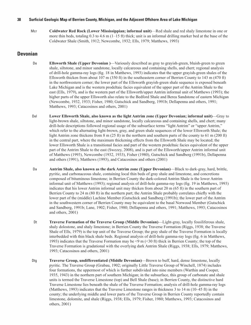
38 Surficial Geologic Map of Berrien County, Michigan, and the Adjacent Offshore Area of Lake Michigan
Mcr Coldwater Red Rock (Lower Mississippian; informal unit)—Red shale and red shaly limestone in one or more thin beds, totaling 0.3 to 4.6 m (1‒15 ft) thick; unit is an informal drilling marker bed at the base of the Coldwater Shale (Smith, 1912; Newcombe, 1932; Ells, 1979; Matthews, 1993)
Devonian
De Ellsworth Shale (Upper Devonian )—Variously described as gray to grayish-green, bluish-green to green shale, siltstone, and minor sandstone, locally calcareous and containing shells, and chert; regional analysis of drill-hole gamma-ray logs (fig. 18 in Matthews, 1993) indicates that the upper grayish-green shales of the Ellsworth thicken from about 107 m (350 ft) in the southeastern corner of Berrien County to 143 m (470 ft) in the northwestern corner; the lower part of the Ellsworth grayish-green shale sequence is exposed beneath Lake Michigan and is the western prodeltaic facies equivalent of the upper part of the Antrim Shale to the east (Ells, 1979), and is the western part of the Ellsworth/upper Antrim informal unit of Matthews (1993); the higher parts of the upper Ellsworth also relate to the Bedford Shale and Berea Sandstone of eastern Michigan (Newcombe, 1932, 1933; Fisher, 1980; Gutschick and Sandberg, 1991b; Dellapenna and others, 1991; Matthews, 1993; Catacosinos and others, 2001)
Del Lower Ellsworth Shale, also known as the light Antrim zone (Upper Devonian; informal unit)—Gray to light-brown shale, siltstone, and minor sandstone, locally calcareous and containing shells, and chert; many drill-hole descriptions followed regional usage of the subsurface terms “light Antrim” or “upper Antrim,” which refer to the alternating light-brown, gray, and green shale sequences of the lower Ellsworth Shale; the light Antrim zone thickens from 8 m (25 ft) in the northern and southern parts of the county to 61 m (200 ft) in the central part, where the maximum thickening effects from the Ellsworth Shale may be located; the lower Ellsworth Shale is a transitional facies and part of the western prodeltaic facies equivalent of the upper part of the Antrim Shale to the east (Swezey, 2008), and is part of the Ellsworth/upper Antrim informal unit of Matthews (1993), Newcombe (1932, 1933), Fisher (1980), Gutschick and Sandberg (1991b), Dellapenna and others (1991), Matthews (1993), and Catacosinos and others (2001)
Da Antrim Shale, also known as the dark Antrim zone (Upper Devonian)—Black to dark-gray, hard, brittle, pyritic, and carbonaceous shale, containing local thin beds of gray shale and limestone, and concretions composed of bituminous limestone; in Berrien County the dark-colored Antrim Shale is the lower Antrim informal unit of Matthews (1993); regional analysis of drill-hole gamma-ray logs (fig. 19 in Matthews, 1993) indicates that his lower Antrim informal unit may thicken from about 20 m (65 ft) in the southern part of Berrien County to 24 m (80 ft) in the northern part; the Antrim Shale probably correlates chiefly with the lower part of the (middle) Lachine Member (Gutschick and Sandberg (1991b); the lower part of the Antrim in the southwestern corner of Berrien County may be equivalent to the basal Norwood Member (Gutschick and Sandberg, 1991b; Lane, 1902; Fisher, 1980; Dellapenna and others, 1991; Matthews, 1993; Catacosinos and others, 2001)
Dt Traverse Formation of the Traverse Group (Middle Devonian)—Light-gray, locally fossiliferous shale, shaly dolostone, and shaly limestone; in Berrien County the Traverse Formation (Riggs, 1938; the Traverse Shale of Ells, 1979) is the top unit of the Traverse Group; the gray shale of the Traverse Formation is locally interbedded with thin black shale beds. Regional analysis of drill-hole gamma-ray logs (fig. 6 in Matthews, 1993) indicates that the Traverse Formation may be <9 m (˂30 ft) thick in Berrien County; the top of the Traverse Formation is gradational with the overlying dark Antrim Shale (Riggs, 1938; Ells, 1979; Matthews, 1993; Catacosinos and others, 2001)
Dtg Traverse Group, undifferentiated (Middle Devonian)—Brown to buff, hard, dense limestone, locally pyritic. The Traverse Group (Grabau, 1902; originally Little Traverse Group of Winchell, 1874) includes four formations, the uppermost of which is further subdivided into nine members (Warthin and Cooper, 1935, 1943) in the northern part of southern Michigan; in the subsurface, this group of carbonate and shale units is termed the Traverse Limestone (top) and Bell Shale (base); in Berrien County, the distinctive hard Traverse Limestone lies beneath the shale of the Traverse Formation; analysis of drill-hole gamma-ray logs (Matthews, 1993) indicates that the Traverse Limestone ranges in thickness 3 to 14 m (10‒45 ft) in the county; the underlying middle and lower parts of the Traverse Group in Berrien County reportedly contain limestone, dolomite, and shale (Riggs, 1938; Ells, 1979; Fisher, 1980; Matthews, 1993; Catacosinos and others, 2001)
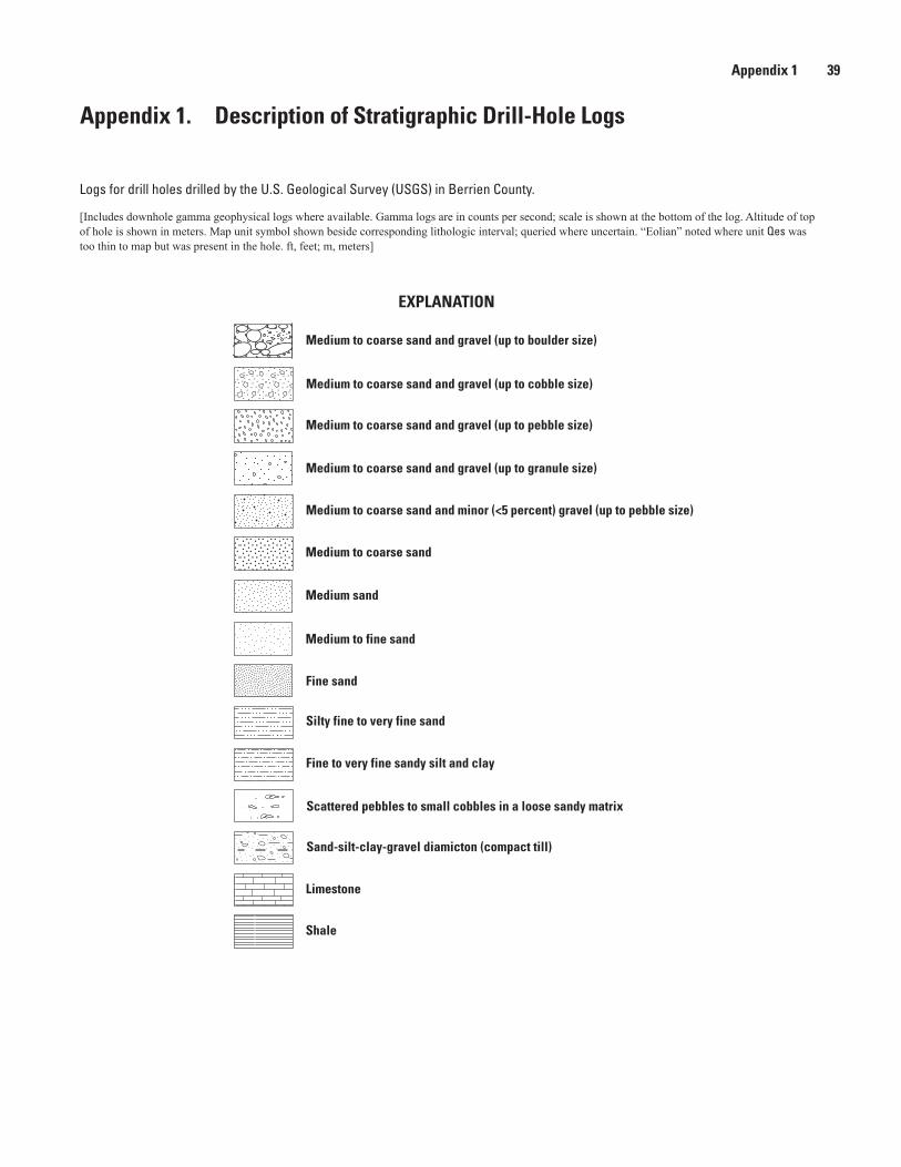
Appendix 1 39
Appendix 1. Description of Stratigraphic Drill-Hole Logs
Logs for drill holes drilled by the U.S. Geological Survey (USGS) in Berrien County.
[Includes downhole gamma geophysical logs where available. Gamma logs are in counts per second; scale is shown at the bottom of the log. Altitude of top of hole is shown in meters. Map unit symbol shown beside corresponding lithologic interval; queried where uncertain. “Eolian” noted where unit Qes was too thin to map but was present in the hole. ft, feet; m, meters]
Medium to coarse sand and gravel (up to boulder size)
EXPLANATION
Medium to coarse sand and gravel (up to cobble size)
Medium to coarse sand and gravel (up to pebble size)
Medium to coarse sand and gravel (up to granule size)
Medium to coarse sand
Medium to coarse sand and minor (<5 percent) gravel (up to pebble size)
Medium sand
Medium to fine sand
Silty fine to very fine sand
Fine to very fine sandy silt and clay
Scattered pebbles to small cobbles in a loose sandy matrix
Sand-silt-clay-gravel diamicton (compact till)
Limestone
Shale
Fine sand
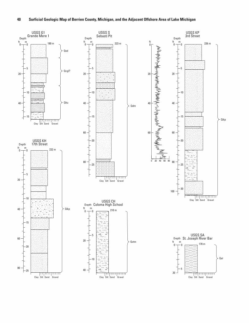
40 Surficial Geologic Map of Berrien County, Michigan, and the Adjacent Offshore Area of Lake Michigan
180 m
232 m
178 m
210 m
Qsd
Qcgl?
Qltu
223 m 226 m
Qdm
Qvtm
Qikp
Qal
Qikp
USGS SSebasti Pit
5
10
15
20
25
0
20
40
60
80
Depthft m
5
0
10
15
0 0 0
20
40
Depthft m
Clay Silt Sand Gravel
Clay Silt Sand GravelClay Silt Sand GravelClay Silt Sand Gravel
Clay Silt Sand Gravel
Clay Silt Sand Gravel
USGS G1Grande Mere 1
USGS CHColoma High School
USGS SASt. Joseph River Bar
5
10
15
20
25
30
0
20
40
60
80
100
Depthft m
0 20 40 60 80
USGS KP3rd Street
USGS KH17th Street
60
40
20
0
5
10
0 0
20
40
Depthft m
0 0
20
Depthft m
5
5
10
15
20
25
0 0
20
40
60
80
Depthft m
ft
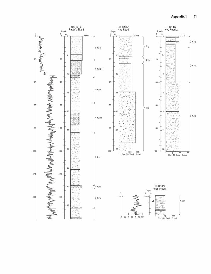
Appendix 1 41
183 m 210 m 213 m
Qllt
Qvtu
Qbll
Qvtu
Qltl
Qdg
Qbg
Qvtu
Qdg
Qbg
Qblm
Qltu
Qcgl?
Qsd
Qllt
Clay Silt Sand GravelClay Silt Sand Gravel
Clay Silt Sand Gravel
Clay Silt Sand Gravel
USGS N1Nye Road 1
USGS N2Nye Road 2
5
10
15
20
25
30
35
40
45
50
0
20
40
60
80
100
120
140
160
USGS P2Peter’s Site 2
160
140
120
100
80
60
40
20
0
0 20 40 60 80 100
5
10
15
20
25
30
20
40
60
80
100
Depthft m
10
15
20
25
30
0
20
40
60
80
100
Depthft m
5
00 0 0
50
160160
0 20 40 60 80 100 120
Depthft m
Depthft m
USGS P2(continued)
ft
ft
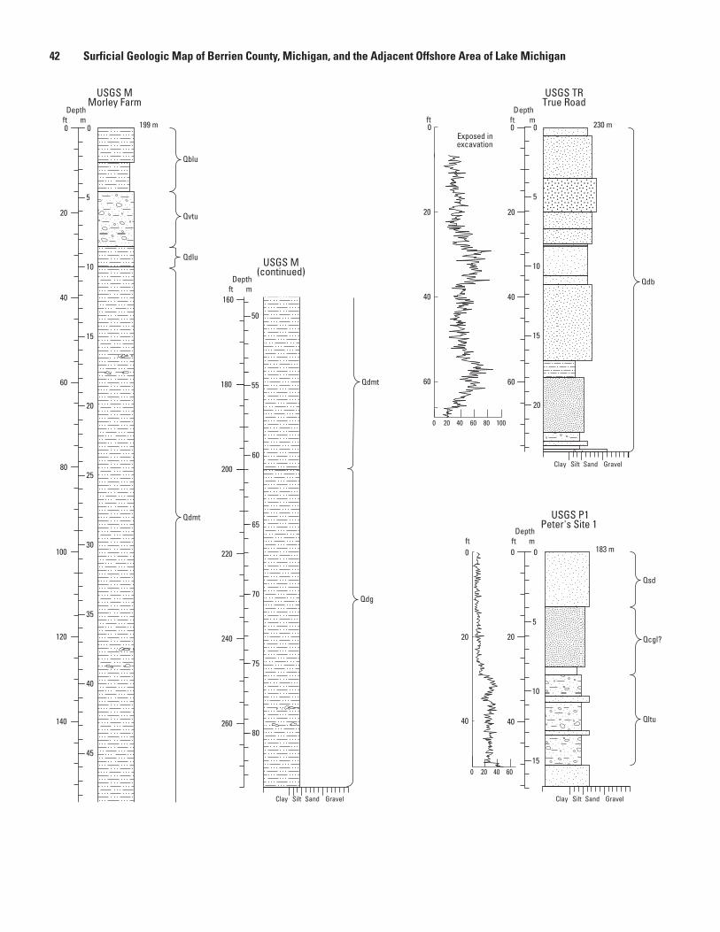
42 Surficial Geologic Map of Berrien County, Michigan, and the Adjacent Offshore Area of Lake Michigan
199 m
183 m
230 m
Qvtu
Qdg
Qdlu
Qdmt
Qdmt
Qblu
Qdb
Exposed inexcavation
Qcgl?
Qsd
Qltu
Clay Silt Sand Gravel Clay Silt Sand Gravel
Clay Silt Sand Gravel
USGS TRTrue Road
USGS M(continued)
USGS MMorley Farm
0
20
40
5
10
15
0
20
40
USGS P1Peter's Site 1
0 20 40 60
0 20 40 60 80 100
0
Depthft m
5
10
15
20
0
0
00
20
40
60
80
100
120
140
160
180
5
10
15
20
25
30
35
40
45
50
55
200
60
65
70
75
80
220
240
260
0
20
40
60
20
40
60
160
180
50
55
Depthft m
Depthft m
Depthft m ft
ft
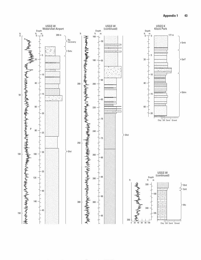
Appendix 1 43
200 m 177 m
Qblm
Qal?
Qmb
Qhd
Qvtu
Norecovery
Mc
Qvlt
Qhd
Qhd
Mc
Qvlt
Clay Silt Sand Gravel
Clay Silt Sand Gravel
USGS W(continued)
USGS WWatervliet Airport
USGS KKlock Park
P
150
100
50
0
250
200
300
5
10
15
20
0
20
40
60
Depthft m
USGS W(continued)
Depthft m
35
40
45
50
55
120
140
160
180
5
10
15
20
25
30
0 00
20
40
60
80
100
Depthft m
240
260
280
300
320
340
180
200
55
60
70
75
80
85
90
95
100
105
65
220
50
160
0 20 40 60 80 100350
320
340
100
105
ft Depthft m
ft
ft
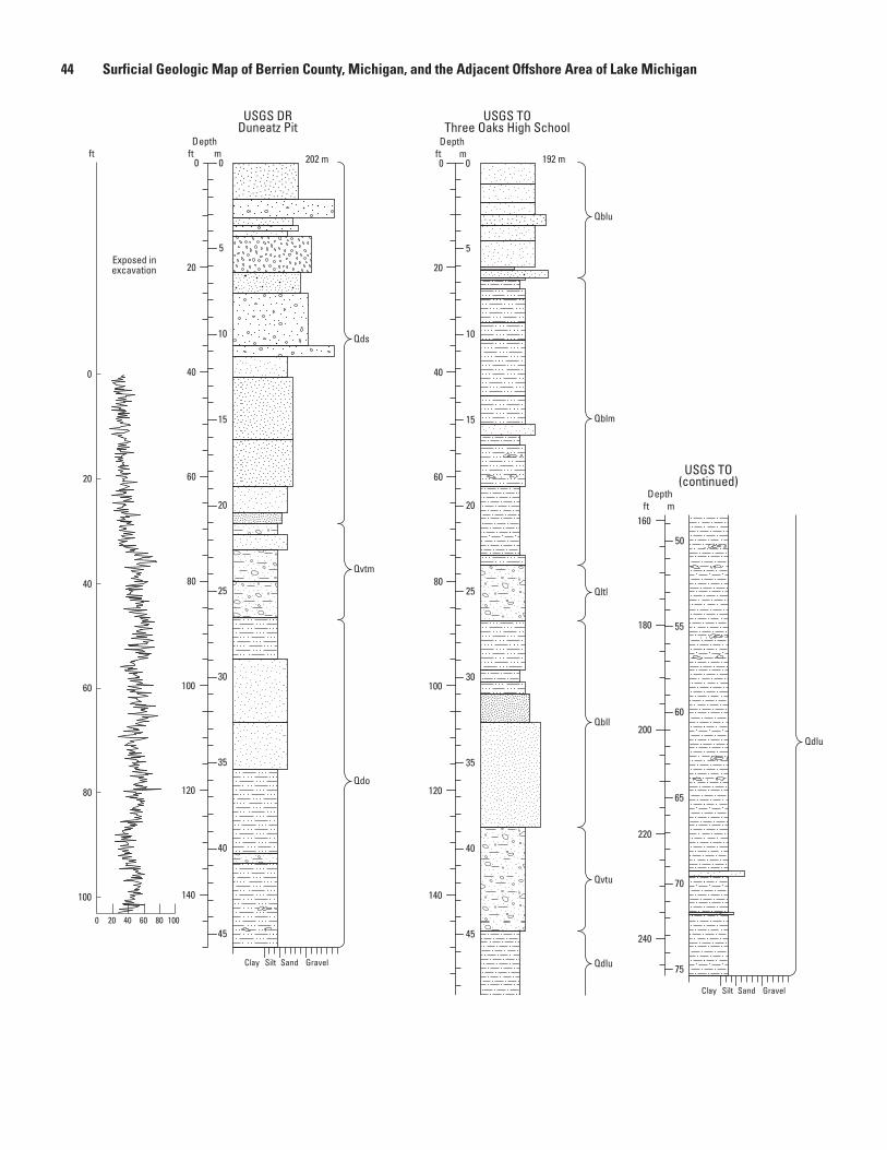
44 Surficial Geologic Map of Berrien County, Michigan, and the Adjacent Offshore Area of Lake Michigan
202 m 192 m
Qltl
Qdo
Qds
Qblm
Qbll
Qdlu
Qvtu
Qblu
Qdlu
Exposed inexcavation
Qvtm
Clay Silt Sand Gravel
Clay Silt Sand Gravel
USGS TO(continued)
USGS TOThree Oaks High School
USGS DRDuneatz Pit
1000 20 40 60 80
40
60
80
0
20
100
5
10
15
20
25
30
35
40
0
20
40
60
80
100
120
Depthft m
Depthft m
140
45
50
55
160
180
200
55
60
65
70
75
220
240
0 00
Depthfft t m
5
10
15
20
25
30
35
40
45
20
40
60
80
100
120
140
50
160
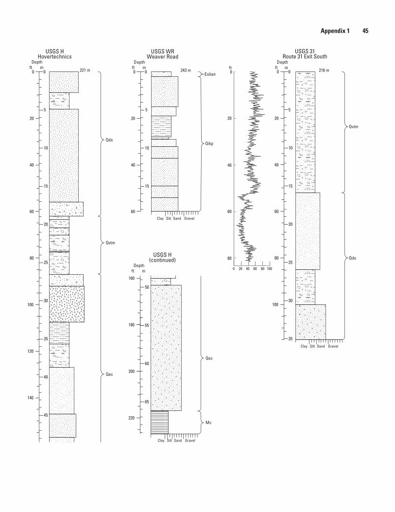
Appendix 1 45
243 m 216 m221 m
Qdo
Qvtm
Qikp
Mc
Qec
Qec
Qvtm
Qds
Eolian
Clay Silt Sand Gravel
Clay Silt Sand Gravel
Clay Silt Sand Gravel
USGS H(continued)
USGS HHovertechnics
USGS 31Route 31 Exit South
USGS WRWeaver Road
0 20 40 60 80 100
20
40
60
80
0
35
5
10
15
20
25
30
0
20
40
60
80
100
Depthft m
5
10
15
0
20
40
60
Depthft m
120
140
160
180
35
40
45
50
55
5
10
15
20
25
30
0 000
20
40
60
80
100
200
220
60
65
55180
ft
160
50
Depthft m
Depthft m
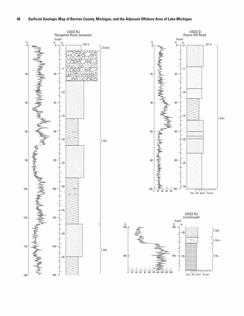
46 Surficial Geologic Map of Berrien County, Michigan, and the Adjacent Offshore Area of Lake Michigan
232 m 221 m
Qdf
Qdr
Qec
Qvlt
Qdf
De
Eolian
Clay Silt Sand Gravel
Clay Silt Sand Gravel
USGS RJRangeline Road Jesswein
140
120
100
80
60
40
20
0
180
USGS DDeans Hill Road
100
80
60
40
20
0
0 20 40 60 80
0 20 40 60 80 100
5
0
20
40
60
80
100
120
140
Depthft m
10
15
20
25
30
35
40
45
50
55180
45
50
55180
5
10
15
20
25
30
00 0
20
40
60
80
100
Depthft m
0 20 40 60 80 100 120 140 160 180 200
USGS RJ(continued)
160
160160
ft
ft
ft
160
Depthft m
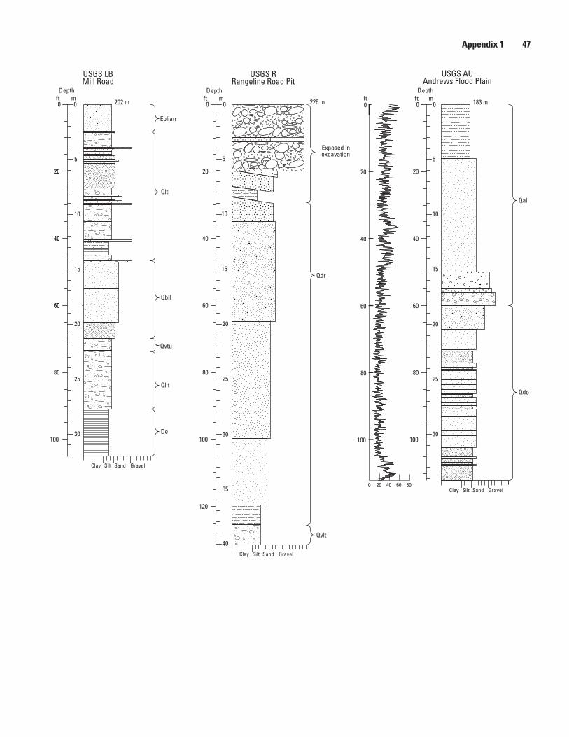
Appendix 1 47
202 m 226 m 183 m
Qbll
Qllt
De
Exposed inexcavation
Qltl
Eolian
Qal
Qdo
Qdr
Qvlt
Qvtu
Clay Silt Sand Gravel
Clay Silt Sand Gravel
Clay Silt Sand Gravel
USGS AUAndrews Flood Plain
0 20 40 60 80
100
80
60
40
20
0
USGS RRangeline Road Pit
5
10
15
20
25
30
0
20
40
60
80
100
Depthft m
Depthft m
5
10
15
20
25
30
35
40
0
20
40
60
80
100
120
20
40
60
USGS LBMill Road
5
10
15
20
25
30
0 000
20
40
60
80
100
Depthft m ft
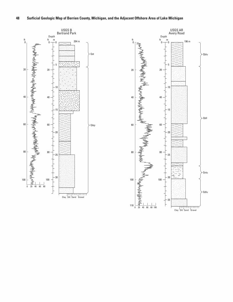
48 Surficial Geologic Map of Berrien County, Michigan, and the Adjacent Offshore Area of Lake Michigan
196 m204 m
Qikp
Qst
Qbll
Qblu
Qvtu
Qdlu
Clay Silt Sand Gravel
Clay Silt Sand Gravel
USGS ARAvery Road
USGS BBertrand Park
1000 20 40 60 80
40
20
0
60
80
100
118
0 20 40 60 80
5
10
15
20
25
30
0
20
40
60
80
100
Depthft m
00 0
Depthft m
5
10
15
20
25
30
35
20
40
60
80
100
20
0
40
60
80
100
ftft
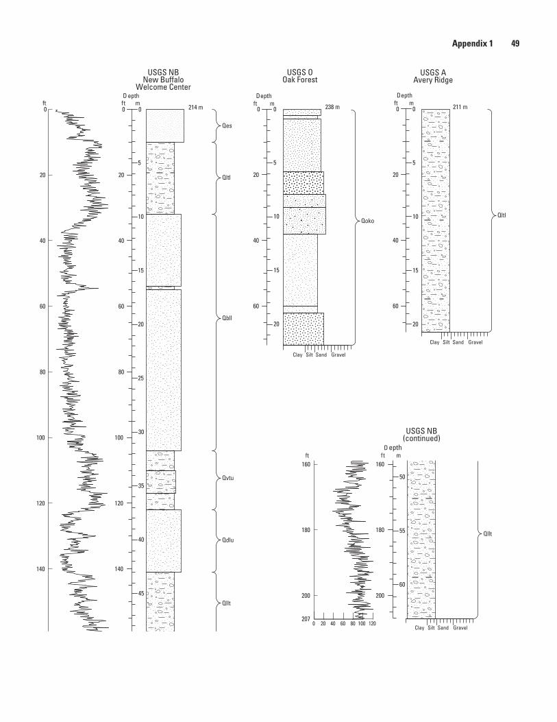
Appendix 1 49
238 m214 m 211 m
QltlQoko
Qbll
Qltl
Qes
Qvtu
Qdlu
Qllt
Qllt
Clay Silt Sand Gravel
Clay Silt Sand Gravel
Clay Silt Sand Gravel
USGS AAvery Ridge
5
0
20
40
60
Depthft m
10
15
20
USGS OOak Forest
5
10
15
25
0
20
40
60
80
D epthft m
D epthft m
20
30
35
40
45
50
100
120
140
160
55
60
180
200
160
140
120
100
80
60
40
20
0
USGS NBNew Buffalo
Welcome Center
USGS NB(continued)
200
180
2070 20 40 60 80 100 120
5
10
15
20
000 0
20
40
60
Depthft m
50
160160
ft
ft

Manuscript approved on June 19, 2017Prepared by the USGS Science Publishing Network Publishing Service Centers Edited by James R. Estabrook, Reston Cartography and graphics by Linda M. Masonic, Reston Layout by James E. Banton, Lafayette Web support by Angela E. Hall, Reston
For more information, contact:Eastern Geology and Paleoclimate Science CenterU.S. Geological Survey926A National Center12201 Sunrise Valley DriveReston, VA 20192http://geology.er.usgs.gov/egpsc/
Stone and others—Surficial G
eologic Map of B
errien County, Michigan, and the A
djacent Offshore A
rea of Lake Michigan—
Scientific Investigations Map 3383
Printed on recycled paper
ISSN 2329-1311 (print)ISSN 2329-132X (online)https://doi.org/10.3133/sim3383