Embed Size (px)
Citation preview
CGS SPECIAL REPORT 217 (REVISED)
Geologic Compilation of Quaternary Surficial Deposits in Southern California
Compiled by Trinda L. Bedrossian, Peter D. Roffers, Cheryl A. Hayhurst,
Jeremy T. Lancaster, and William R. Short*
Digital Preparation by
Solomon McCrea, Barbara Wanish, Jim Thompson, Anita Carney, Michelle A. Myers, and Shannon Utley
December 2012
A Project for the Department of Water Resources by the California Geological Survey
*Professional Licenses and Certifications
Trinda L. Bedrossian, PG 3363, CEG 1064 Cheryl A. Hayhurst, PG 8556
Jeremy T. Lancaster, PG 7692, CEG 2379 William R. Short, PG 4576, CEG 1429, CHG 61
Copyright 2012 by the California Department of Conservation California Geological Survey. All rights reserved. No part of this publication may be reproduced without written consent of the California Geological Survey. The Department of Conservation makes no warranties as to the suitability of this product for any given purpose.
EDMUND G. BROWN, Governor JOHN LAIRD, Secretary MARK NECHODOM, Director JOHN G. PARRISH, Ph.D., State Geologist STATE OF CALIFORNIA THE RESOURCES AGENCY DEPARTMENT OF CONSERVATION CALIFORNIA GEOLOGICAL SURVEY
CALIFORNIA GEOLOGICAL SURVEY JOHN G. PARRISH, Ph.D.
STATE GEOLOGIST
Copyright © 2012 by the California Department of Conservation. All rights reserved. No part of this publication may be reproduced without written consent of the California Geological Survey. The Department of Conservation makes no warranties as to the suitability of this product for any particular purpose.
iii
CALFIORNIA GEOLOGICAL SURVEY SPECIAL REPORT 217 (REVISED)
Geologic Compilation of Quaternary Surficial Deposits in Southern California
CONTENTS
Introduction .................................................................................................................................................. 1
Background ................................................................................................................................................... 1
Scope of Work ............................................................................................................................................... 2
Area Mapped ............................................................................................................................................ 2
Tasks .......................................................................................................................................................... 2
Compilation of the Source GIS Database ...................................................................................................... 4
Compilation of the Derivative GIS Database................................................................................................. 4
PDF Version of the Derivative Maps ............................................................................................................. 8
Simplified Map of Areas that may Include Alluvial Fans ............................................................................... 9
Use of Maps .................................................................................................................................................. 9
Acknowledgments ......................................................................................................................................... 9
References Cited ......................................................................................................................................... 10
Appendix A: Digital Geologic Source Data Files Used in CGS Compilation ................................................. 11
Appendix B: SCAMP Classification of Quaternary Deposits (2000) ............................................................ 14
Appendix C: Description of Derivative Geologic Map Units ....................................................................... 15
Appendix D: Correlation of Derivative Geologic Map Units ....................................................................... 18
Appendices E and F: Simplified Map of Areas that may Include Alluvial Fans ........................................... 19
LIST OF FIGURES
Figure 1: Simplified Index Map of Quadrangles Included in the Revised CGS Compilation ........................ 2
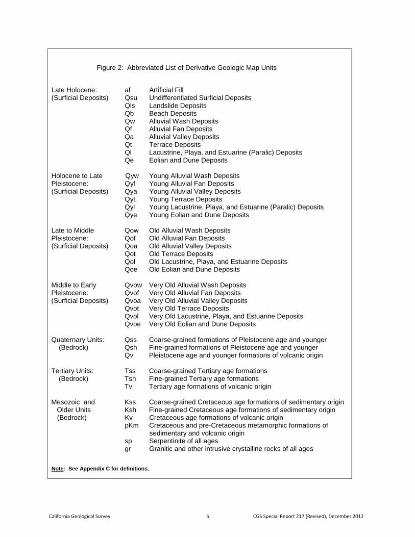
Figure 2: Abbreviated List of Derivative Geologic Map Units ....................................................................... 6
LIST OF PLATES Plate 1: Project Index Map
Plate 2: Legend and Correlation of Derivative Geologic Map Units
Plate 3: Amboy 30’ x 60’ Quadrangle (Revised)
Plate 4: West Half of Blythe 30’ x 60’ Quadrangle
Plate 5: Cuddeback Lake 30’ x 60’ Quadrangle (Revised)
California Geological Survey iv CGS Special Report 217 (Revised), December 2012
Plate 6: Eastern Three-Quarters of the Cuyama 30’ x 60’ Quadrangle (Revised)
Plate 7: El Cajon 30’ x 60’ Quadrangle
Plate 8: Onshore Portion of the Long Beach 30’ x 60’ Quadrangle
Plate 9: Los Angeles 30’ x 60’ Quadrangle (Revised)
Plate 10: California Portion of the Mesquite Lake 30’ x 60’ Quadrangle
Plate 11: Onshore Portion of the Oceanside 30’ x 60’ Quadrangle
Plate 12: Orange County
Plate 13: San Bernardino 30’ x 60’ Quadrangle
Plate 14: Onshore Portion of the San Diego 30’ x 60’ Quadrangle
Plate 15: San Gabriel River Hydrologic Unit
Plate 16: Santa Ana 30’ x 60’ Quadrangle (Revised)
Plate 17: Onshore Portion of the Santa Barbara 30’ x 60’ Quadrangle
Plate 18: Sheep Hole Mountains 30’ x 60’ Quadrangle
Plate 19: East Half of the Taft 30’ x 60’ Quadrangle
Plate 20: Tehachapi 30’ x 60’ Quadrangle
Plate 21: Ivanpah 30’ x 60’ Quadrangle
Plate 22: Lancaster 30’ x 60’ Quadrangle
Plate 23: Newberry Springs 30’ x 60’ Quadrangle
Plate 24: Palm Springs 30’ x 60’ Quadrangle
Plate 25: Soda Mountains 30’ x 60’ Quadrangle
GEOLOGIC COMPILATION OF QUATERNARY SURFICIAL DEPOSITS IN SOUTHERN CALIFORNIA A Project for the Department of Water Resources By the California Geological Survey By
Trinda L. Bedrossian, CEG, Peter Roffers, Cheryl A. Hayhurst, PG, Jeremy T. Lancaster, CEG, and William R. Short, CEG
Digital Preparations by Solomon McCrea, Barbara Wanish, Jim Thompson, Anita Carney, Michelle A. Myers, and Shannon Utley
December 2012 INTRODUCTION This revision to the Department of Conservation’s California Geological Survey (CGS) Special Report 217 includes the addition of geologic mapping of surficial deposits for seven new 30’ x 60’ (1: 100,000 scale) quadrangles in southern California and the revision of five quadrangles previously mapped under the 2010 edition of the report (Figure 1 and Appendix A). This version of CGS Special Report 217 also includes a Simplified Map of Areas that May Include Alluvial Fans, mapped at the 1:500,000 scale (Appendix E) and depicted at the 1:250,000 scale in 11” x 17” format for each of the 30’ x 60’ quadrangles shown on the Index Map (Figure 1 and Appendix F). CGS will continue to update the seamless geologic mapping dataset in the 10 southern California counties as new source data and funding become available. BACKGROUND Since November 2007, CGS has been a technical consultant to the Department of Water Resources (DWR) and its Alluvial Fan Task Force (AFTF) for a 10-county southern California area including San Bernardino, Riverside, Los Angeles, Ventura, Santa Barbara, San Luis Obispo, Kern, Orange, Imperial, and San Diego. In this capacity, CGS has assisted in identifying geologic hazards and natural resources that could affect or be affected by development on alluvial fans, and in preparing guidance for alluvial fan floodplain management. CGS has also conducted original research on how geologic maps may be used to help identify where flooding and other hazards may occur on alluvial fans in southern California. Older geologic maps of California typically lump recent alluvial deposits into a single unit identified as Qal, Quaternary age alluvium (less than about 1.8 million years). Many modern geologic maps, including those that focus on urbanizing areas within southern California, show additional details of Quaternary age deposits on alluvial fans and floodplains such as depositional environment, relative age, and grain size. These deposits can be related to a number of geologic hazards including amplification of seismic shaking, liquefaction, and collapsible soils. They can also be used to show where sediment has been deposited on alluvial fans in the geologically recent past. Because areas of most recent deposition during Late Holocene time (within the last 500 years) are the most likely to be areas of flooding and deposition in the future, they are a high priority for evaluating the potential for alluvial fan flooding. Conversely, areas underlain by older alluvial fan deposits are less likely to be prone to alluvial fan flooding.
California Geological Survey 2 CGS Special Report 217 (Revised), December 2012
The CGS Geologic Compilation of Quaternary Surficial Deposits in Southern California (CGS Compilation) was designed as a regional-scale planning tool to assist DWR, the AFTF, and local communities in evaluating future development on alluvial fans. A detailed Geographic Information System (GIS)-based data set (Source GIS Database) presents a compilation of recent high-resolution geologic maps of Quaternary age and older deposits that cover portions of southern California from Santa Barbara to San Diego. A second data set (Derivative GIS Database) merges geologic mapping from various authors, and at different scales, into a common seamless format that normalizes and differentiates the various alluvial fan and related Quaternary deposits into four main age categories (Late Holocene=most recent, Holocene to Late Pleistocene=young, Late to Middle Pleistocene=old, and Middle to Early Pleistocene=very old) for the entire area at a scale of 1:100,000. The primary delivery format of the data is intended to be both a GIS-based data set and an interactive online web map viewer. A Portable Document File (PDF) version of the 1:100,000 scale derivative maps is also provided to assist elected officials, local floodplain managers, developers, environmental groups, representatives from various governmental agencies, and the public in the rapid identification of areas subject to previous and potential future flooding and other geologic hazards on alluvial fans and floodplains. SCOPE OF WORK
Area Mapped
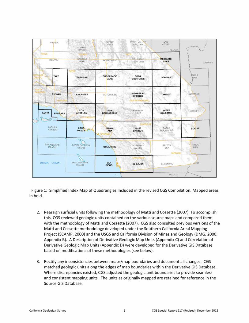
The CGS Compilation covers approximately 35,000 square miles between Santa Barbara and San Diego, including portions of the following counties in southern California: Imperial, Inyo, Kern, Los Angeles, Orange, Riverside, San Bernardino, San Diego, San Luis Obispo, Santa Barbara, and Ventura. Geologic maps were compiled from areas within the following 30’x 60’ quadrangles (1:100,000 scale): Amboy, Blythe, Cuddeback Lake, Cuyama, El Cajon, Ivanpah, Lancaster, Long Beach, Los Angeles, Mesquite Lake, Newberry Springs, Oceanside, Palm Springs, Santa Barbara, San Bernardino, San Diego, Santa Ana, Sheep Hole Mountains, Soda Mountains, Taft, and Tehachapi (Figure 1). In addition, CGS compiled 1:100,000 scale derivative data for Orange County and the San Gabriel River Hydrologic Unit to illustrate how the database can be used to depict information on a jurisdictional or watershed basis. Tasks
The focus of the CGS Compilation was to collect available geologic mapping of alluvial deposits within the southern California region and compile them into a more generalized, seamless GIS database. To complete the project, CGS was asked by DWR to:
1. Collect digital files and hard copies of geologic maps. For this task, CGS compiled available published and unpublished geological maps, primarily from the U.S. Geological Survey (USGS) and CGS. The digital source maps used by CGS in the Source GIS Database are listed in Appendix A. In quadrangles where published 100,000 scale digital source data was not available, CGS used the derivative map units as a basis for new Quaternary mapping (Appendix A). The Source and Derivative GIS Database layers contain attribute hyperlinks to additional references used by CGS to verify geologic information within each quadrangle.
California Geological Survey 3 CGS Special Report 217 (Revised), December 2012
Figure 1: Simplified Index Map of Quadrangles Included in the revised CGS Compilation. Mapped areas in bold.
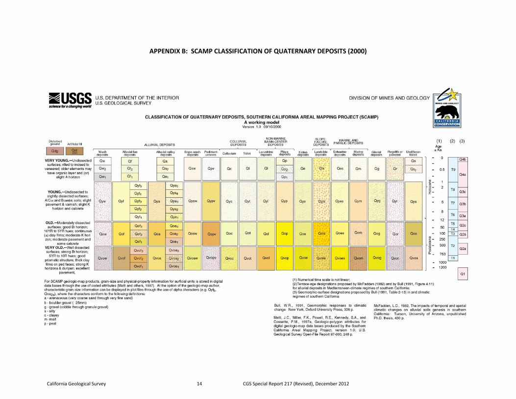
2. Reassign surficial units following the methodology of Matti and Cossette (2007). To accomplish this, CGS reviewed geologic units contained on the various source maps and compared them with the methodology of Matti and Cossette (2007). CGS also consulted previous versions of the Matti and Cossette methodology developed under the Southern California Areal Mapping Project (SCAMP, 2000) and the USGS and California Division of Mines and Geology (DMG, 2000, Appendix B). A Description of Derivative Geologic Map Units (Appendix C) and Correlation of Derivative Geologic Map Units (Appendix D) were developed for the Derivative GIS Database based on modifications of these methodologies (see below).
3. Rectify any inconsistencies between maps/map boundaries and document all changes. CGS matched geologic units along the edges of map boundaries within the Derivative GIS Database. Where discrepancies existed, CGS adjusted the geologic unit boundaries to provide seamless and consistent mapping units. The units as originally mapped are retained for reference in the Source GIS Database.
California Geological Survey 4 CGS Special Report 217 (Revised), December 2012
4. Create a seamless ArcGIS database of the geologic map with the associated metadata, Project Index Map with references, a stratigraphic Correlation of Derivative Geologic Map Units, and a brief geologic report that describes the geologic units. In addition, CGS prepared a Geologic Labels spreadsheet for each quadrangle showing how geologic units in the Source GIS Database are correlated with categories used in the Derivative GIS Database. A correlation of equivalent deposits across the whole southern California CGS Compilation area is presented in the GIS-based table entitled Correlation of Derivative and Source Geologic Map Units.
5. Prepare a PDF version of the geologic map that may be accessed by the public in a user-friendly format. The CGS Compilation is to be published as an official CGS publication, with CGS and DWR logos, and be available on the CGS and DWR websites, and as a DVD from CGS. It will also be distributed to libraries and referenced to the geologic community. All available data will be provided in a format that can be placed on AFTF-related servers.
COMPILATION OF THE SOURCE GIS DATABASE In preparing the Source GIS Database, CGS used basic geologic data, including geology polygons, faults and other line work, compiled in digital format at a scale of 1:100,000 for each 30’x 60’ quadrangle mapped by the USGS and CGS (Appendix A). To maintain integrity of the GIS data in both the Source GIS Database and the Derivative GIS Database, CGS performed topology reconciliation to prevent gaps and overlaps in the geologic polygons. In addition, CGS used the following base layers across the entire mapped area:
• Springs and Wet Areas - GNIS layer of geographic names from the USGS • Streams and Lakes - “NHD_HighRes” and “compiled_lakes2” from the National
Hydrography Dataset Plus (NHDPlus) and the California Department of Fish and Game • Counties – “cnty24k09_1” from CAL FIRE • Hydrologic Units – “CalWater, Version 2.2.1” from the California Interagency Watershed
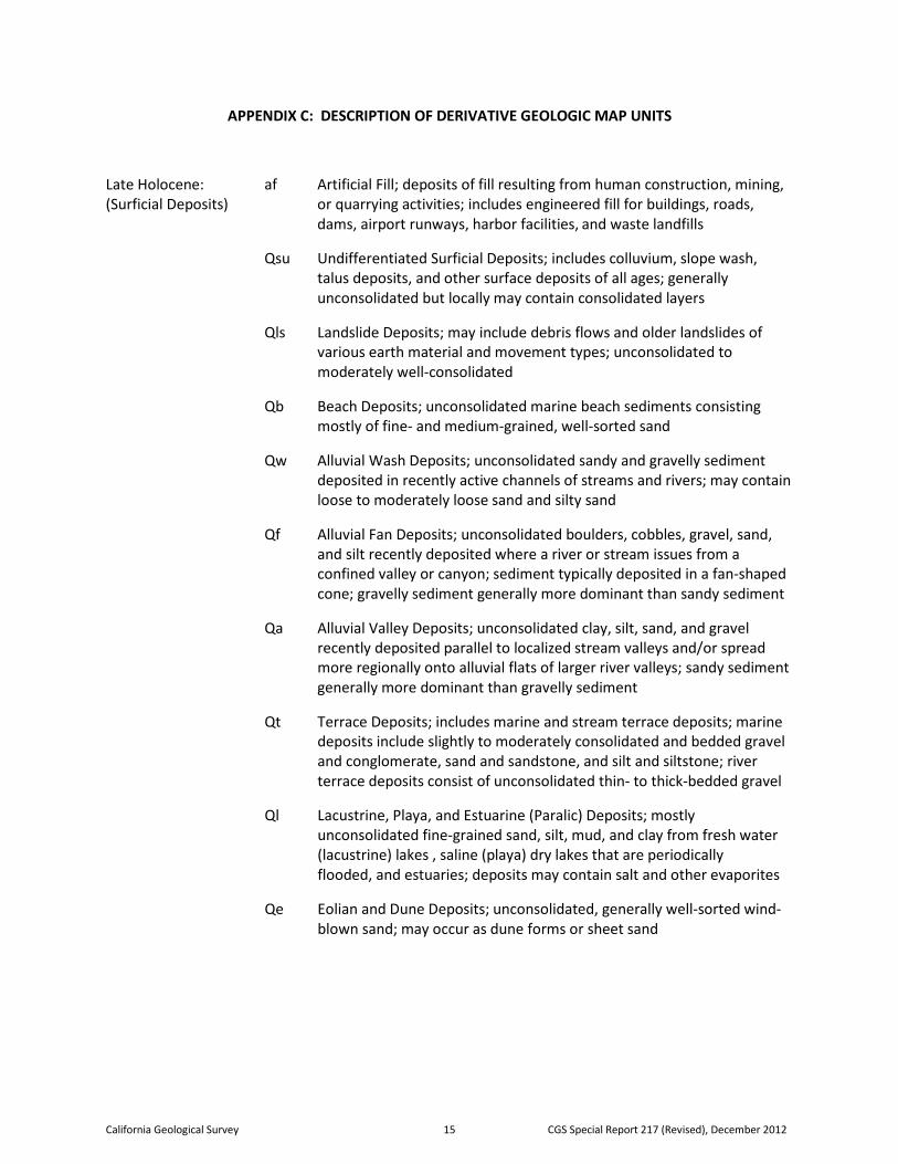
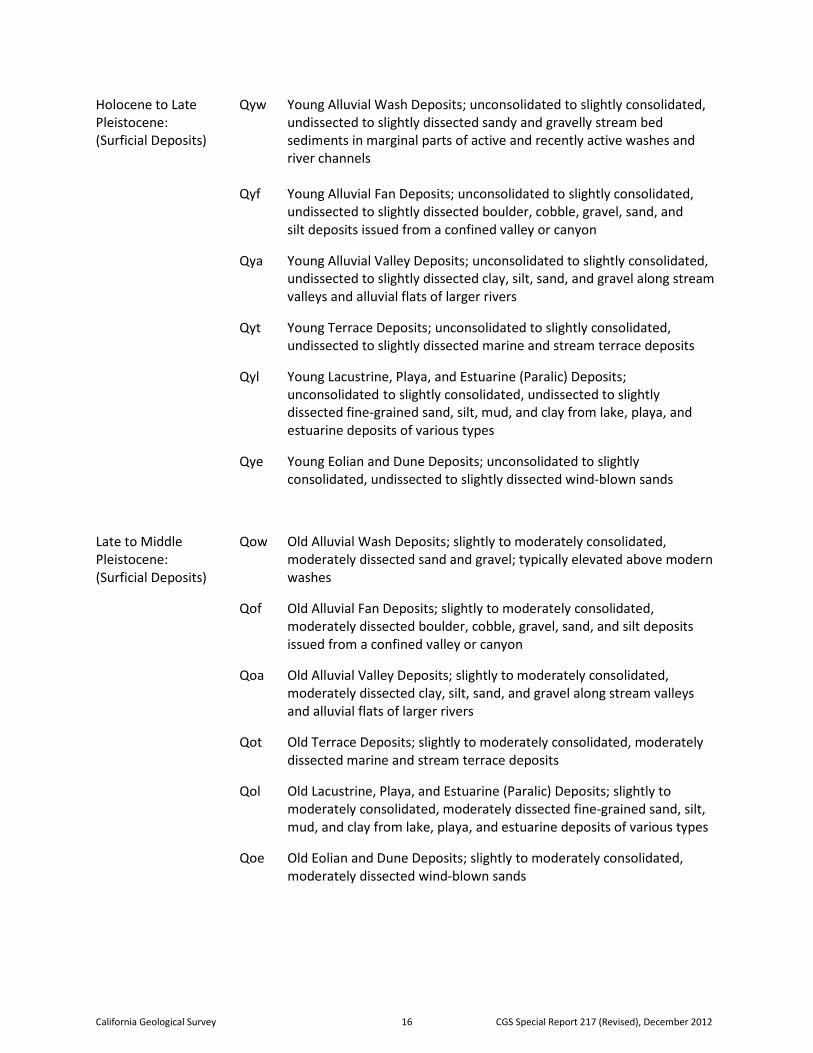
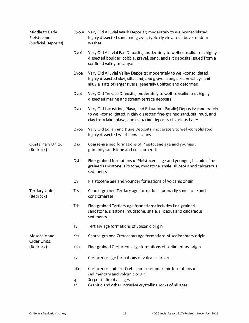
Mapping Committee (IWMC) To provide additional consistency, CGS also derived contour base maps throughout the entire mapped area at a 50-meter interval from the USGS National Elevation Dataset (NED) and performed base layer annotations to accentuate the clarity of mapped Quaternary surficial deposits. Data files used in the Source GIS Database are listed in the project metadata and ReadMe files. COMPILATION OF THE DERIVATIVE GIS DATABASE The goal of the CGS Compilation was to represent southern California’s complex geology in a user-friendly format that depicts alluvial deposits and bedrock in several generalized categories. More than 2100 geologic units, found on the digital maps published primarily by the USGS and CGS, are retained in the Source GIS Database. To assist in identifying areas where flooding and sediment deposition occurred in the geologically recent past, CGS reassigned these geologic units into a Derivative GIS Database consisting of 40 categories based on age, rock type, and nature of deposits (Figure 2, Appendices C and D). Quaternary surficial deposits in the Description of Derivative Geologic Map Units (Appendix C) are divided into 28 categories modified from the methodology of Matti and Cossette (2007), SCAMP (2000),
California Geological Survey 5 CGS Special Report 217 (Revised), December 2012
and the USGS and DMG (2000, Appendix B). The CGS Correlation of Derivative Geologic Map Units chart (Appendix D) represents a hybrid of the Matti and Cossette (2007), SCAMP (2000), and USGS and DMG (2000) nomenclature to account for variations in rock types and age ranges used in prior geologic mapping between the coastal and inland areas of southern California. The various types of surficial deposits in the CGS Compilation include: artificial fill; undifferentiated surficial deposits; landslide deposits; beach deposits; alluvial wash deposits; alluvial fan deposits; alluvial valley deposits; terrace deposits; lacustrine, playa, and estuarine deposits; and eolian and dune deposits. While specific variations in age and physical properties exist within units on each source map, CGS retained the basic premise of Matti and Cossette (2007) that surficial deposits within each of the Quaternary derivative map units formed during a particular range of geologic time, have a similar depositional origin, and have generally similar physical properties. Within the 28 derivative units, progressively older surficial deposits are typically better consolidated and more highly dissected by erosion, have more developed and/or eroded soil profiles with stronger degrees of weathering and surface armoring, and occupy a higher topographic position within alluvial fan and floodplain terrains. Geologic bedrock formations from the source geologic maps are divided into 12 categories on the CGS derivative maps, based on age and rock type. Bedrock units in the derivative version of the maps were combined to include: coarse-grained sedimentary bedrock; fine-grained sedimentary bedrock; bedrock of volcanic origin; metamorphic formations of sedimentary and volcanic origin; serpentinite; and granitic and other intrusive crystalline rocks. The bedrock categories can be used to provide a general understanding of the relative erodibility of the upland materials and the general character of the derived sediments. Colors selected for the various surficial deposits and bedrock units shown on the maps and in the Correlation of Derivative Geologic Map Units (Appendix D) are based on a combination of colors and Patterns used by Matti and Cossette (2007) and current USGS geologic mapping standards (Federal Geographic Data Committee, 2006; USGS, 2007). Artificial fill and other deposits generated by human activities are designated with a darker gray tone. Quaternary surficial deposits are depicted in a range of lighter gray, yellow, and tan hues that generally intensify with age. Quaternary (Qss, Qsh, Qv), Tertiary (Tss, Tsh, Qv) and Mesozoic and older bedrock units (Kss, Ksh, Kv) of sedimentary and volcanic origin are represented by various shades of orange, brown, and green respectively. Cretaceous and pre-Cretaceous age metamorphic rocks (pKm) are blue; serpentinite of all ages (sp) is purple; and granitic and other intrusive crystalline rocks of all ages (gr) are pink. Quaternary surficial units and geologic formational names compiled in the original geologic source data are correlated with derivative categories used by CGS in the Geologic Labels spreadsheet for each quadrangle. In general, CGS retained the original geologic source data name, description, and age of surficial deposits and geologic formations listed in the Geologic Labels spreadsheets. However, CGS changed age categories, designated as “upper” and “lower” in the source data, to “late” and “early” on the derivative data for purposes of correlating the age of geologic units across the derivative compilation. In addition, original descriptions in the source data explanations were abbreviated in some cases to indicate the basis on which the derivative correlations were made. Because there is a lack of consistency in terminology, map units, and age designations among the source data quadrangles used for the CGS Compilation, inconsistencies in formational names, ages, and capitalization exist throughout the individual Geologic Labels spreadsheets prepared by CGS. The same inconsistencies are retained within the correlation of equivalent deposits across the whole southern California project as presented in the GIS-based table entitled Correlation of Derivative and Source Geologic Map Units.
California Geological Survey 6 CGS Special Report 217 (Revised), December 2012
Figure 2: Abbreviated List of Derivative Geologic Map Units
Late Holocene: af Artificial Fill (Surficial Deposits) Qsu Undifferentiated Surficial Deposits Qls Landslide Deposits Qb Beach Deposits Qw Alluvial Wash Deposits Qf Alluvial Fan Deposits Qa Alluvial Valley Deposits Qt Terrace Deposits Ql Lacustrine, Playa, and Estuarine (Paralic) Deposits Qe Eolian and Dune Deposits Holocene to Late Qyw Young Alluvial Wash Deposits Pleistocene: Qyf Young Alluvial Fan Deposits (Surficial Deposits) Qya Young Alluvial Valley Deposits Qyt Young Terrace Deposits Qyl Young Lacustrine, Playa, and Estuarine (Paralic) Deposits Qye Young Eolian and Dune Deposits Late to Middle Qow Old Alluvial Wash Deposits Pleistocene: Qof Old Alluvial Fan Deposits (Surficial Deposits) Qoa Old Alluvial Valley Deposits Qot Old Terrace Deposits Qol Old Lacustrine, Playa, and Estuarine Deposits Qoe Old Eolian and Dune Deposits Middle to Early Qvow Very Old Alluvial Wash Deposits Pleistocene: Qvof Very Old Alluvial Fan Deposits (Surficial Deposits) Qvoa Very Old Alluvial Valley Deposits Qvot Very Old Terrace Deposits Qvol Very Old Lacustrine, Playa, and Estuarine Deposits Qvoe Very Old Eolian and Dune Deposits Quaternary Units: Qss Coarse-grained formations of Pleistocene age and younger (Bedrock) Qsh Fine-grained formations of Pleistocene age and younger Qv Pleistocene age and younger formations of volcanic origin Tertiary Units: Tss Coarse-grained Tertiary age formations (Bedrock) Tsh Fine-grained Tertiary age formations Tv Tertiary age formations of volcanic origin Mesozoic and Kss Coarse-grained Cretaceous age formations of sedimentary origin Older Units Ksh Fine-grained Cretaceous age formations of sedimentary origin (Bedrock) Kv Cretaceous age formations of volcanic origin pKm Cretaceous and pre-Cretaceous metamorphic formations of sedimentary and volcanic origin sp Serpentinite of all ages gr Granitic and other intrusive crystalline rocks of all ages
Note: See Appendix C for definitions.
California Geological Survey 7 CGS Special Report 217 (Revised), December 2012
In preparing the derivative geologic maps, CGS retained the boundaries of the Quaternary age surficial deposits shown on the source maps with very few revisions. Boundaries of more detailed Quaternary age source map unit subdivisions are shown without label within the generalized derivative map unit. This indicates more detailed geologic information is available in the Source GIS Database. For example, an area designated Qyf (young alluvial fan deposits) on the derivative geologic map may have been subdivided on the source geologic map into several units (Qyf1, Qyf2, Qyf3, etc.) to distinguish different depositional surfaces and compositions. If local jurisdictions require more detailed mapping in these areas, the original source data can be retrieved and further evaluated by qualified professionals. In quadrangles where published digital geologic source data was not available at the 100,000 scale, CGS compiled maps of Quaternary surficial deposits from existing references at various scales using the 40 project derivative units as a basis. CGS augmented its mapping with the interpretation of surficial units from topography, aerial photography, and other digital imagery and the assessment of soil physiography, geomorphology, surface dissection, texture, slope, relief, parent materials, and profile development. Most locations of Quaternary and bedrock faults compiled from existing sources were not verified. In some places, CGS retained contacts previously mapped by others; in other places CGS remapped contacts between bedrock and Quaternary surficial deposits, faults, and other geologic features using the 40 project derivative units. No digital source data is provided in the Source GIS Database for these quadrangles: East ½ Taft, Tehachapi, Lancaster, Palm Springs, and Soda Mountains (Appendix A). However, references used in the original compilations are cited. CGS rectified inconsistencies along the boundaries of the various mapped areas to create a seamless Derivative GIS Database, but retained links to the original mapping in the Source GIS Database so that the more detailed geologic information can be retrieved. Where differences in the mapping of geologic units along quadrangle boundaries were severe, CGS consulted other geologic references listed in the reference documents and various types of aerial photography to resolve rock type, location, and age discrepancies. Because field review was limited, CGS made some edge match judgments solely on the basis of age and/or areal extent of the mapped units along the borders of each quadrangle. For example, if geologic rock type boundaries matched on adjacent quadrangles, but there was a discrepancy in the age (e.g., Qoa vs Qvoa), CGS considered the stratigraphic position of the unit in relationship to other geologic units mapped in the overall area, as well as the extent of the mapped units on both quadrangles. In most cases, CGS designated the younger age (i.e., Qoa) along the mapped boundaries. However, if selection of the Qoa designation would result in more extensive areal changes on one derivative map than the other, then the Qvoa designation was selected for purposes of the edge match only. CGS also developed the Project Index Map to depict areas contained in the CGS Compilation. The Source and Derivative GIS Database layers contain attributes that enable feature-based hyperlinks to reference documents that list the digital geologic source maps used in the compilation and other geologic references pertinent to each 100,000 scale quadrangle mapped. To assist local planning agencies and other interested parties in accessing information within a given area, CGS added a county overlay from CAL FIRE and hydrologic unit overlay from CalWater. These can be used to excerpt geologic information on a jurisdictional basis, similar to the Orange County and San Gabriel Hydrologic Unit demonstration maps in the PDF version of the derivative maps (see below). Data files used in the Derivative GIS Database are listed in the project metadata and ReadMe files.
California Geological Survey 8 CGS Special Report 217 (Revised), December 2012
PDF VERSION OF THE DERIVATIVE MAPS As requested by DWR, CGS prepared a PDF version of the derivative geologic maps in the CGS Compilation for those who do not have GIS capabilities. The following 100,000 scale 30’ x 60’ quadrangles are included in the PDF files: Amboy (Plate 3, revised), Blythe (Plate 4), Cuddeback Lake (Plate 5, revised), Cuyama (Plate 6, revised), El Cajon (Plate 7), Long Beach (Plate 8), Los Angeles (Plate 9, revised), Mesquite Lake (Plate 10), Oceanside (Plate 11), San Bernardino (Plate 13), San Diego (Plate 14), Santa Ana (Plate 16, revised), Santa Barbara (Plate 17), Sheep Hole Mountains (Plate 18), East ½ Taft (Plate 19), Tehachapi (Plate 20), Ivanpah (Plate 21), Lancaster (Plate 22), Newberry Springs (Plate 23), Palm Springs (Plate 24), and Soda Mountains (Plate 25). In addition, CGS included PDF versions of the derivative maps for Orange County (Plate 12) and the San Gabriel Hydrologic Unit (Plate 15) to demonstrate how the seamless derivative map can be used to excerpt specific areas. The PDF versions of the maps, viewable in Adobe Reader, are available on the CGS website (www.conservation.ca.gov/cgs); as links through the DWR (www.water.ca.gov) and AFTF (http://aftf.csusb.edu/) websites; and as CGS Special Report 217, Geologic Compilation of Quaternary Surficial Deposits in Southern California. Information on the PDF maps includes:
• The mapped derivative geologic units imposed on a shaded relief base with 50-meter contours. • An Index to USGS 7.5’ Quadrangles (1:24,000) covered within each map. • An abbreviated Map Explanation that focuses on the general type and location of Quaternary
and other units found in each quadrangle. • References that refer to the digital geologic source used in compilation of the derivative
geologic map, references used in developing the map units, and other references used specifically in developing the Map Explanation for each quadrangle.
• Map Units and the Correlation of Map Units specific to each map. Other information contained in the PDF files includes:
• The Project Index Map (Plate 1). This map is linked to accompanying reference documents. • Legend and Correlation of Derivative Geologic Map Units (Plate 2). These define the 40
derivative geologic units developed for the entire project. • A Geologic Labels spreadsheet for each quadrangle. Each spreadsheet shows how the geologic
units in the source data were correlated to the derivative map units and presents an abbreviated description of each geologic unit. Original source data maps and pamphlets must be consulted for more detailed descriptions of the source geologic units within each quadrangle.
• References. These documents reflect additional references consulted in verifying the derivative geologic data on each of the 100,000 scale maps.
• Correlation of Derivative and Source Geologic Map Units. This table correlates the original source geologic data from each quadrangle mapped to the 40 derivative map units across the entire project area. More than 2100 original geologic map units are represented.
The ReadMe file provided in the digital version and on the DVD includes information on the structure of the folders, listing of the GIS files used in preparation of the maps, and a discussion of printing issues that may be encountered.
California Geological Survey 9 CGS Special Report 217 (Revised), December 2012
SIMPLIFIED MAP OF AREAS THAT MAY INCLUDE ALLUVIAL FANS In addition to compiling the 100,000 scale maps of surficial deposits, CGS developed a GIS relational database for DWR and the AFTF depicting the general distribution of areas underlain by Quaternary-age sediment less than 2 million years old (Qs) and those considered to be Upland areas (U) consisting of bedrock or exhibiting topographic relief such as hills and mountains for the entire 10-county area (Appendix E). The Quaternary-age sediments are subdivided in areas that may contain alluvial fans (Qs1), and topographically low areas including playa lakes and coastal lowlands (Qs2). The database is part of the AFTF Integrated Approach that may be used by landowners, developers, planners, regulators, and the public to assist in screening sites that may be located on alluvial fans. If a site falls within an area that may contain alluvial fans, more specific information or detailed studies may be required. The GIS data are included in the digital version and the DVD or this publication. For convenience, the 1:500,000 scale data is also provided in PDF format both on an aerial base (Plate E-1) and on an Digital Elevation Model (DEM) hillshade base (Plate E-2), and as a series of regional advisory maps at a scale of 1:250,000 Appendix F, Plates F-1 through F-42) for each 30’ x 60’ quadrangles in the 10- county area of southern California. USE OF MAPS Southern California includes some of the most complex and varied geology in the western United States. Topographic relief ranges from sub-sea level to rugged mountains. Large areas of low relief along coastal and desert regions are densely populated and/or rapidly urbanizing. Low-lying drainage basins, adjacent to steep fault-bounded and landslide-prone mountain ranges, are subject to periodic debris laden floods and debris flows. In some areas, both the magnitude and areal extent of devastating landslides, flooding, and debris flows increase when seasonal wildfires are followed by heavy rainfall. For this reason, information contained in the CGS Compilation should not be used as a substitute for detailed geologic studies in any specific area. The database is intended only for rapid regional identification of areas subject to previous and potential future flooding and other geologic hazards on alluvial fans and floodplains. Local jurisdictions may require a more detailed analysis by professionals where such areas are identified. ACKNOWLEDGEMENTS The GIS Compilation was funded by DWR under Interagency Agreement DWR 4600008323/DOC1008-016R. Although the original agreement was to include only those areas where digital mapping already exists, it is the intent of both CGS and DWR to include additional areas within southern California as 100,000 scale maps and funding become available. The development of 100,000 scale databases for the CGS Compilation was truly a cooperative, and interactive, effort on behalf of CGS geologists and GIS staff. The original concept for the project was proposed to DWR by CGS Alluvial Fan Task Force members Bill Short, Jeremy Lancaster, and Tom Spittler. Work for the project was done primarily within the Forest and Watershed Geology (FWG) Program under Supervising Engineering Geologist Bill Short. However, FWG geologists consulted early in the process with Supervising Engineering Geologist Chris Wills and staff in the Regional Geologic Hazards Mapping (RGHM) Program to ensure consistency in format and terminology with other Quaternary and Alluvial Fan Task Force-related mapping projects being conducted by CGS. These included the compilation of the 1:500,000 scale Simplified Map of Areas That May Include Alluvial Fans (Appendices E and F) and more detailed mapping of the Quaternary age alluvial deposits in the Lancaster, Palm
California Geological Survey 10 CGS Special Report 217 (Revised), December 2012
Springs, East 1/2 of Taft, and Tehachapi 30’ x 60’ quadrangles by Clif Davenport, Tim Dawson, Wayne Haydon, Cheryl Hayhurst, Janice Hernandez, and Jeremy Lancaster (Interagency Agreement DWR460008540/DOC1008-022R). Senior Engineering Geologist Trinda Bedrossian coordinated the CGS Compilation and developed the 40 derivative geologic map units used in the compilation, as modified from the work of Matti and Cossette (2007), SCAMP (2000), and the USGS and DMG (2000). Peter Roffers and Solomon McCrea created the Project Index Map and directed the compilation of source maps within the Source GIS Database, as well as the development of the derivative map colors and the Geologic Labels spreadsheets for each quadrangle. Solomon McCrea developed the GIS table entitled Correlation of Derivative and Source Geologic Map Units. Barbara Wanish, Jim Thompson, Anita Carney, John Carotta, Michelle Myers, Shannon Utley, and Milind Patel provided assistance with annotations and other layers within the Source GIS Database. CGS geologists Trinda Bedrossian, Cheryl Hayhurst, Peter Roffers, and Michelle Myers compiled the Derivative GIS Database maps, including geologic unit conversions on the Geologic Labels spreadsheets, references, edge-matching of quadrangle boundaries, and the PDF map explanations for each quadrangle. At various stages throughout the project, CGS geologists Bill Bryant, Clif Davenport, Tim Dawson, Carlos Gutierrez, Will Harris, Wayne Haydon, Pam Irvine, Jeremy Lancaster, Michelle Myers, Brian Olson, George Saucedo, John Schlosser, Bill Short, Tom Spittler, Shannon Utley, Dave Wagner, and Chris Wills provided input on geologic details. CGS geologists Pam Irvine, Jeremy Lancaster, and Brian Olson also provided review of the first 16 PDF map explanations and the Santa Ana, Orange County, and San Gabriel River Hydrologic Unit demonstration maps. Anita Carney and Lee Wallinder also assisted with DVD production. Thanks are also extended to USGS geologists and GIS staff Dave Miller, Jonathan Matti, Geoff Phelps, Bob Powell, and Doug Hirschberg for providing in progress map databases and/or technical comments on the Ivanpah, Newberry Springs, Palm Springs, and Soda Mountains quadrangles. Last but not least, the project would not have been feasible without funding from DWR and the availability of 100,000 scale digital files of quadrangles mapped by both the USGS and CGS (Appendix A). REFERENCES CITED Federal Geographic Data Committee, 2006, FGDC digital cartographic standard for geologic map symbolization: Prepared for the Federal Geographic Data Committee by the U.S. Geological Survey, Reston, VA, Federal Geographic Data Committee Document Number FGDC-STD-013-2006, 290 p., 2 plates. Matti, J.C., and Cossette, P.M., 2007, Classification of surficial materials, Inland Empire Region, southern California: conceptual and operational framework: U.S. Geological Survey, Open-File Report. Southern California Areal Mapping Project, 2000, A proposed classification for surficial geologic materials in southern California, version 1.0.: U.S. Geological Survey, Open-File Report. U.S. Geological Survey, 2007, Divisions of geologic time – major chronostratigraphic and geochronologic units: USGS Fact Sheet 2007-3015, 2 p. U.S. Geological Survey and California Division of Mines and Geology, 2000, Classification of Quaternary deposits, Southern California Areal Mapping Project (SCAMP), a working model, version 1.0: (09/10/2000).
California Geological Survey 11 CGS Special Report 217 (Revised), December 2012
APPENDIX A: DIGITAL GEOLOGIC SOURCE DATA FILES USED IN CGS COMPILATION
Bedford, D.R., Miller, D.M., and Phelps, G.A., 2010, Surficial geologic map of the Amboy 30x60 minute quadrangle, California,
Amboy (Revised)
http://pubs.usgs.gov/sim/3109/index/html: U.S. Geological Survey, Scientific Investigations Map 3109, 26, p., scale 1:100,000.
Stone, P., 2006, Geologic map of the west half of the Blythe 30’ by 60’ quadrangle, Riverside County, California and La Paz County, Arizona,
Blythe
http://ngmdb.usgs.gov/Prodesc/proddesc_76909.htm: U.S. Geological Survey, Scientific Investigations Map 2922, scale 1:100,000.
Amoroso, L., and Miller, D.M., 2006, Surficial geologic map and geodatabase of the Cuddeback Lake 30’x 60’ quadrangle, San Bernardino and Kern counties, California,
Cuddeback Lake (Revised, edges only)
http://pubs.usgs.gov/of/2006/1276: U.S. Geological Survey, Open-File Report 2006-1276, scale 1:100,000.
Kellogg, K.S., Minor, S.A., and Cossette, P.M., 2008, Geologic map of the eastern three-quarters of the Cuyama 30’ by 60’ quadrangle, California,
Cuyama (Revised, edges only)
http://pubs.usgs.gov/sim/3002/: U.S. Geological Survey, Scientific Investigations Map 3002, scale 1:100,000.
Todd, V.R., 2004, Preliminary geologic map of the El Cajon 30’ x 60’ quadrangle, southern California,
El Cajon
http://pubs.usgs.gov/of/2004/1361: U.S. Geological Survey, Open-File Report 2004-1361, scale 1:100,000.
Miller, D.M., 2012, Surficial geologic map of the Ivanpah 30’ x 60’ quadrangle, San Bernardino County, California, and Clark County, Nevada ,
Ivanpah
http://pubs.usgs.gov/sim/3206/index.html: U.S. Geological Survey, Scientific Investigations Map 3206, 31 p., scale 1:100,000.
Lancaster (New compilation, no digital source data)
Saucedo, G.J., Greene, H.G., Kennedy, M.P., and Bezore, S.P., 2009 (in progress), Geologic map of the Long Beach 30’ by 60’ quadrangle, California: A digital database,
Long Beach
http://conservation.ca.gov/cgs/rghm/rgm/Pages/preliminary_geologic_maps.aspx: California Geological Survey, Preliminary Geologic Map, scale 1:100,000.
California Geological Survey 12 CGS Special Report 217 (Revised), December 2012
California Geological Survey, 2009 (in Progress), Preliminary geologic map of the Los Angeles 30’ by 60’ quadrangle, California: A digital database: California Geological Survey, Preliminary Geologic Map, version 12/22/09, scale 1:100,000.
Los Angeles (Revised, edges only)
Schmidt, K.M., and McMackin, M., 2006, Preliminary surficial geologic map database of the Mesquite Lake 30’ x 60’ quadrangle, California and Nevada,
Mesquite Lake
http://pubs.er.usgs.gov/usgspubs/ofr/ofr20061035: U.S. Geological Survey, Open-File Report 2006-1035, scale 1:100,000.
Phelps, G.A., Bedford, D.R., Lidke, D.J., Miller, D.M., and Schmidt, K.S., 2011, Preliminary Quaternary geologic map and database of the Newberry Springs 30’ x 60’ quadrangle, California: U.S. Geological Survey, Open-File Report 2011-1044, 103 p., scale 100,000.
Newberry Springs
Kennedy, M.P., and Tan, S.S., 2007, Geologic map of the Oceanside 30’ by 60’ quadrangle, California: A digital database,
Oceanside
http://conservation.ca.gov/cgs/rghm/rgm/Pages/preliminary_geologic_maps.aspx: California Geological Survey, Regional Geologic Map No. 2, scale 1:100,000.
Kennedy, M.P., and Tan, S.S., 2007, Geologic map of the Oceanside 30’ by 60’ quadrangle, California: A digital database,
Orange County
http://conservation.ca.gov/cgs/rghm/rgm/Pages/preliminary_geologic_maps.aspx: California Geological Survey, Regional Geologic Map No. 2, scale 1:100,000.
Morton D.M., and Miller, F.K., 2006, Geologic map of the San Bernardino and Santa Ana 30’ x 60’ quadrangles, California, http://ngmdb.usgs.gov/Prodesc/proddesc_78686.htm: U.S. Geological Survey, Open-File Report 2006-1217, scale 1:100,000.
Saucedo, G.J., Greene, H.G., Kennedy, M.P., and Bezore, S.P., 2009 (in progress), Geologic map of the Long Beach 30’ by 60’ quadrangle, California: A digital database, http://conservation.ca.gov/cgs/rghm/rgm/Pages/preliminary_geologic_maps.aspx: California Geological Survey, Preliminary Geologic Map, scale 1:100,000.
Palm Springs (New compilation, no digital source data)
Morton D.M., and Miller, F.K., 2006, Geologic map of the San Bernardino and Santa Ana 30’ x 60’ quadrangles, California,
San Bernardino
http://ngmdb.usgs.gov/Prodesc/proddesc_78686.htm: U.S. Geological Survey, Open-File Report 2006-1217, scale 1:100,000.
Kennedy, M.P., and Tan, S.S., 2008, Geologic map of the San Diego 30’ by 60’ quadrangle, California,
San Diego
http://conservation.ca.gov/cgs/rghm/rgm/Pages/preliminary_geologic_maps.aspx: California Geological Survey, Regional Geologic Map No. 3, scale 1:100,000.
California Geological Survey 13 CGS Special Report 217 (Revised), December 2012
California Geological Survey, 2009 (in progress), Preliminary geologic map of the Los Angeles 30’ by 60’ quadrangle, California: A digital database,
San Gabriel River Hydrologic Unit
http://conservation.ca.gov/cgs/rghm/rgm/Pages/preliminary_geologic_maps.aspx: California Geological Survey, Preliminary Geologic Map, version 12/22/09, scale 1:100,000.
Morton D.M., and Miller, F.K., 2006, Geologic map of the San Bernardino and Santa Ana 30’ x 60’ quadrangles, California, http://ngmdb.usgs.gov/Prodesc/proddesc_78686.htm: U.S. Geological Survey, Open-File Report 2006-1217, scale 1:100,000.
Saucedo, G.J., Greene, H.G., Kennedy, M.P., and Bezore, S.P., 2009 (in progress), Geologic map of the Long Beach 30’ by 60’ quadrangle, California: A digital database, http://conservation.ca.gov/cgs/rghm/rgm/Pages/preliminary_geologic_maps.aspx: California Geological Survey, Preliminary Geologic Map, scale 1:100,000.
Morton D.M., and Miller, F.K., 2006, Geologic map of the San Bernardino and Santa Ana 30’ x 60’ quadrangles, California,
Santa Ana (Revised, edges only)
http://ngmdb.usgs.gov/Prodesc/proddesc_78686.htm: U.S. Geological Survey, Open-File Report 2006-1217, scale 1:100,000.
Gutierrez, C.I., Tan, S.S., and Clahan, K.B., 2008 (in progress), Geologic map of the east half Santa Barbara 30’ x 60’ quadrangle, California,
Santa Barbara
http://conservation.ca.gov/cgs/rghm/rgm/Pages/preliminary_geologic_maps.aspx: California Geological Survey, Preliminary Geologic Map, scale 1:100,000.
Minor, S.A., Kellogg, K.S., Stanley, R.G., Gurrola, L.D., Keller, E.A., and Brandt, T.R., 2009, Geologic map of the Santa Barbara coastal plain area, Santa Barbara county, California, http://pubs.usgs.gov/sim/3001: U.S. Geological Survey, Scientific Investigations Map 3001, scale 1:100,000.
Howard, K.A., 2002, Geologic map of the Sheep Hole Mountains 30’ x 60’ quadrangle, San Bernardino and Riverside counties, California,
Sheep Hole Mountains
http://ngmdb.usgs.gov/Prodesc/proddesc_51545.htm: U.S. Geological Survey, Miscellaneous Field Studies, Map MF-2344, scale 1:100,000.
Soda Mountains (New compilation, no digital source data)
Taft (New compilation, no digital source data)
Tehachapi
(New compilation, no digital source data)
California Geological Survey 14 CGS Special Report 217 (Revised), December 2012
APPENDIX B: SCAMP CLASSIFICATION OF QUATERNARY DEPOSITS (2000)
California Geological Survey 15 CGS Special Report 217 (Revised), December 2012
APPENDIX C: DESCRIPTION OF DERIVATIVE GEOLOGIC MAP UNITS
Late Holocene: af Artificial Fill; deposits of fill resulting from human construction, mining, (Surficial Deposits) or quarrying activities; includes engineered fill for buildings, roads, dams, airport runways, harbor facilities, and waste landfills
Qsu Undifferentiated Surficial Deposits; includes colluvium, slope wash, talus deposits, and other surface deposits of all ages; generally unconsolidated but locally may contain consolidated layers
Qls Landslide Deposits; may include debris flows and older landslides of various earth material and movement types; unconsolidated to moderately well-consolidated
Qb Beach Deposits; unconsolidated marine beach sediments consisting mostly of fine- and medium-grained, well-sorted sand
Qw Alluvial Wash Deposits; unconsolidated sandy and gravelly sediment deposited in recently active channels of streams and rivers; may contain loose to moderately loose sand and silty sand
Qf Alluvial Fan Deposits; unconsolidated boulders, cobbles, gravel, sand, and silt recently deposited where a river or stream issues from a confined valley or canyon; sediment typically deposited in a fan-shaped cone; gravelly sediment generally more dominant than sandy sediment
Qa Alluvial Valley Deposits; unconsolidated clay, silt, sand, and gravel recently deposited parallel to localized stream valleys and/or spread more regionally onto alluvial flats of larger river valleys; sandy sediment generally more dominant than gravelly sediment
Qt Terrace Deposits; includes marine and stream terrace deposits; marine deposits include slightly to moderately consolidated and bedded gravel and conglomerate, sand and sandstone, and silt and siltstone; river terrace deposits consist of unconsolidated thin- to thick-bedded gravel
Ql Lacustrine, Playa, and Estuarine (Paralic) Deposits; mostly unconsolidated fine-grained sand, silt, mud, and clay from fresh water (lacustrine) lakes , saline (playa) dry lakes that are periodically flooded, and estuaries; deposits may contain salt and other evaporites
Qe Eolian and Dune Deposits; unconsolidated, generally well-sorted wind- blown sand; may occur as dune forms or sheet sand
California Geological Survey 16 CGS Special Report 217 (Revised), December 2012
Holocene to Late Qyw Young Alluvial Wash Deposits; unconsolidated to slightly consolidated, Pleistocene: undissected to slightly dissected sandy and gravelly stream bed (Surficial Deposits) sediments in marginal parts of active and recently active washes and river channels Qyf Young Alluvial Fan Deposits; unconsolidated to slightly consolidated, undissected to slightly dissected boulder, cobble, gravel, sand, and silt deposits issued from a confined valley or canyon
Qya Young Alluvial Valley Deposits; unconsolidated to slightly consolidated, undissected to slightly dissected clay, silt, sand, and gravel along stream valleys and alluvial flats of larger rivers
Qyt Young Terrace Deposits; unconsolidated to slightly consolidated, undissected to slightly dissected marine and stream terrace deposits
Qyl Young Lacustrine, Playa, and Estuarine (Paralic) Deposits; unconsolidated to slightly consolidated, undissected to slightly dissected fine-grained sand, silt, mud, and clay from lake, playa, and estuarine deposits of various types
Qye Young Eolian and Dune Deposits; unconsolidated to slightly consolidated, undissected to slightly dissected wind-blown sands
Late to Middle Qow Old Alluvial Wash Deposits; slightly to moderately consolidated, Pleistocene: moderately dissected sand and gravel; typically elevated above modern (Surficial Deposits) washes
Qof Old Alluvial Fan Deposits; slightly to moderately consolidated, moderately dissected boulder, cobble, gravel, sand, and silt deposits issued from a confined valley or canyon
Qoa Old Alluvial Valley Deposits; slightly to moderately consolidated, moderately dissected clay, silt, sand, and gravel along stream valleys and alluvial flats of larger rivers
Qot Old Terrace Deposits; slightly to moderately consolidated, moderately dissected marine and stream terrace deposits
Qol Old Lacustrine, Playa, and Estuarine (Paralic) Deposits; slightly to moderately consolidated, moderately dissected fine-grained sand, silt, mud, and clay from lake, playa, and estuarine deposits of various types
Qoe Old Eolian and Dune Deposits; slightly to moderately consolidated, moderately dissected wind-blown sands
California Geological Survey 17 CGS Special Report 217 (Revised), December 2012
Middle to Early Qvow Very Old Alluvial Wash Deposits; moderately to well-consolidated, Pleistocene: highly dissected sand and gravel; typically elevated above modern (Surficial Deposits) washes
Qvof Very Old Alluvial Fan Deposits; moderately to well-consolidated, highly dissected boulder, cobble, gravel, sand, and silt deposits issued from a confined valley or canyon
Qvoa Very Old Alluvial Valley Deposits; moderately to well-consolidated, highly dissected clay, silt, sand, and gravel along stream valleys and alluvial flats of larger rivers; generally uplifted and deformed
Qvot Very Old Terrace Deposits; moderately to well-consolidated, highly dissected marine and stream terrace deposits
Qvol Very Old Lacustrine, Playa, and Estuarine (Paralic) Deposits; moderately to well-consolidated, highly dissected fine-grained sand, silt, mud, and clay from lake, playa, and estuarine deposits of various types
Qvoe Very Old Eolian and Dune Deposits; moderately to well-consolidated, highly dissected wind-blown sands
Quaternary Units: Qss Coarse-grained formations of Pleistocene age and younger; (Bedrock) primarily sandstone and conglomerate Qsh Fine-grained formations of Pleistocene age and younger; includes fine- grained sandstone, siltstone, mudstone, shale, siliceous and calcareous sediments
Qv Pleistocene age and younger formations of volcanic origin
Tertiary Units: Tss Coarse-grained Tertiary age formations; primarily sandstone and (Bedrock) conglomerate
Tsh Fine-grained Tertiary age formations; includes fine-grained sandstone, siltstone, mudstone, shale, siliceous and calcareous sediments
Tv Tertiary age formations of volcanic origin
Mesozoic and Kss Coarse-grained Cretaceous age formations of sedimentary origin Older Units: (Bedrock) Ksh Fine-grained Cretaceous age formations of sedimentary origin Kv Cretaceous age formations of volcanic origin pKm Cretaceous and pre-Cretaceous metamorphic formations of sedimentary and volcanic origin sp Serpentinite of all ages gr Granitic and other intrusive crystalline rocks of all ages

California Geological Survey 18 CGS Special Report 217 (Revised), December 2012
APPENDIX D: CORRELATION OF DERIVATIVE GEOLOGIC MAP UNITS*
California Geological Survey 19 CGS Special Report 217(Revised), December 2012
APPENDICES E AND F: SIMPLIFIED MAP OF AREAS THAT MAY INCLUDE ALLUVIAL FANS
The Department of Conservation's California Geological Survey (CGS) has provided the Department of Water Resources (DWR) and its Alluvial Fan Task Force (AFTF) with technical assistance on identifying geologic hazards and natural resources that could affect or be affected by development on alluvial fans for the 10 southern California counties of Imperial, Kern, Los Angeles, Orange, Riverside, San Bernardino, San Diego, San Luis Obispo, Santa Barbara, and Ventura. The primary AFTF work product entitled, The Integrated Approach for Sustainable Development on Alluvial Fans (Integrated Approach), was completed in July 2010. The Integrated Approach provides a suite of screening tools to assist stakeholders in identifying potential hazards and benefits associated with individual alluvial fan sites prior to project design. These tools include information on how to identify the general distribution of alluvial fans and assess their relative hazard to alluvial fan flooding for areas where existing information is unavailable. These are known as the Alluvial Fan (AF) planning tools.
Background
This GIS relational database, entitled Simplified Map of Areas That May Include Alluvial Fans, was developed by CGS and is designated for use as AF1. The database provides the general distribution of areas underlain by Quaternary-age (less than two million years old) sediments (Qs) and those areas considered to be Upland (areas consisting of bedrock or exhibiting topographic relief such as hills and mountains). The Quaternary-age sediments are subdivided into: (Qs1) areas that may contain alluvial fans, and (Qs2) topographically low areas including playa lakes and coastal lowlands. Given the gradational nature of the transition between the distal portion of an alluvial fan and an alluvial plain or playa lake, areas within the Qs2 category may include the distal portion of alluvial fans. In addition to the GIS database, the AF1 data is provided for convenience in Portable Document Format (PDF) as a 1:500,000 scale map (Appendix E), both on an aerial (Plate E-1) and a Digital Elevation Model (DEM) hillshade base (Plate E-2), and as a series of regional advisory maps at a scale of 1:250,000 (Appendix F, Plates F-1 through F-42) for each individual 30’ x 60’ quadrangle in the 10 county area of southern California.
The AF1 GIS database and maps are part of the AFTF Integrated Approach that may be used by land owners, developers, planners, regulators, and the public to assist in screening sites to identify if they may be located on an alluvial fan. If a site falls within an area that may contain alluvial fans, more specific information or detailed studies may be required to determine the potential for a proposed development to be affected by alluvial fan flooding.
Purpose
Existing published surficial geologic map data from the CGS and the U.S. Geological Survey (USGS) were used where available in digital form, and where the level of detail was adequate to assemble this database. The method used for this compilation is described in CGS Special Report 217, Geologic Compilation of Quaternary Surficial Deposits in Southern California (Bedrossian, Roffers, and Hayhurst, 2010, updated 2012). For areas where there are no published maps showing adequate definition of Quaternary age units, engineering geologists from CGS interpreted the boundaries of Quaternary sedimentary deposits using digital raster data, and manually digitized these boundaries at a screen scale of approximately 1:50,000. Digital raster data used for interpretation and digitizing included 7.5-minute USGS topographic maps, 2005 and 2009 1-meter resolution National Agriculture Imagery Program (NAIP) imagery, ESRI ArcGIS World Imagery Service, and USGS 10-meter DEM (National Elevation Dataset). Variations to these data include slope and hillshade maps derived from DEM, and color
Methods
California Geological Survey 20 CGS Special Report 217(Revised), December 2012
infrared NAIP. The polygons representing Quaternary sediments were then integrated with the published information using ArcGIS to provide a seamless database for the entire AFTF study area. Due to the scale of the GIS database and associated maps, Qs and Upland polygons less than 40 acres in area are not represented.
The Simplified Map of Areas That May Include Alluvial Fans is intended to provide information on the general distribution of alluvial fan deposits specifically for the AFTF Integrated Approach process (AF1), and is not intended for unrelated uses. Representation of this data set, either digital, or on paper, should not exceed, or show finer detail than, a scale of 1:100,000 (1-inch equals about 1½ miles).
Limitations
The database and associated maps do not replace Federal Emergency Management Agency (FEMA) maps or guidelines for determining if a site is located on an alluvial fan, and do not differentiate “active” from “inactive” alluvial fan surfaces per FEMA Guidelines and Specifications for Mapping Partners - Appendix G (FEMA, 2003).
Additionally, the database and maps are compiled from many data sources. In the processes of compiling published geologic data mapped under different surficial geologic nomenclatures it was found that while one group of mappers differentiated fan deposits from valley alluvium, others did not. Because of this, it was necessary to combine valley alluvium with fan deposits, resulting in the incorporation of alluvium that is either isolated, or within canyons far beyond areas commonly considered as the topographic apex of a fan. The advantage of incorporating these alluvial units is that smaller “side canyon” type alluvial fans are included in the data. Therefore, depending on the location and data source, the data may show the Qs1 polygon cut off at the mountain front, as is consistent with the manual digitizing of some of the maps, or the Qs1 polygon extending deep into the mountain range, as is consistent with polygon areas resulting from CGS compilation mapping.
Lastly, because of the vast differences in nomenclature in the source data, and the compounding effect of using both a digital compilation, and manual digitizing, the final product is not a geologic map, and does not conform to any specific geologic mapping nomenclature, or the North American Stratigraphic Code.
References
Alluvial Fan Task Force, 2010, The Integrated Approach for Sustainable Development on Alluvial Fans: Water Resources Institute, California State University, San Bernardino, for the California Department of Water Resources, 183 p.
Bedrossian, T.L., Roffers, P., and Hayhurst, C.A., 2010, Geologic Compilation of Quaternary Surficial Deposits in Southern California: California Geological Survey, Special Report 217, map scale 1:100,000.
California Division of Mines and Geology and California Geological Survey, 1:250,000 scale Geologic Maps (where available).
ESRI, ArcGIS World Imagery Service: various scales and years, last accessed May 11, 2012, http://services.arcgisonline.com/arcgis/services
Federal Emergency Management Agency, 2003, Guidelines and Specifications for Flood Hazard Mapping Partners; Appendix G: Guidance for Alluvial Fan Flooding Analyses and Mapping: 33p.
California Geological Survey 21 CGS Special Report 217(Revised), December 2012
Gesch, D.B., 2007, The National Elevation Dataset: in Maune, D. (editor), Digital Elevation Model Technologies and Applications: The DEM Users Manual, 2nd Edition: Bethesda, Maryland, American Society for Photogrammetry and Remote Sensing, p. 99-118.
Gesch, D., Oimoen, M., Greenlee, S., Nelson, C., Steuck, M., and Tyler, D., 2002, The National Elevation Dataset: Photogrammetric Engineering and Remote Sensing, v. 68, no. 1, p. 5-11.
U.S. Department of Agriculture, Farm Service Agency-Aerial Photography Field Office, National Agriculture Imagery Program (NAIP), 2005a, 1-meter resolution.
U.S. Department of Agriculture, Farm Service Agency-Aerial Photography Field Office, National Agriculture Imagery Program (NAIP), 2005b, color infrared, 1-meter resolution.
U.S. Department of Agriculture, Farm Service Agency-Aerial Photography Field Office, National Agriculture Imagery Program (NAIP), 2009a, 1-meter resolution.
U.S. Department of Agriculture, Farm Service Agency-Aerial Photography Field Office, National Agriculture Imagery Program (NAIP), 2009b, color infrared, 1-meter resolution.
U. S. Geological Survey, 7.5’ Topographic Quadrangle Maps (where available)