Embed Size (px)
Citation preview
Khumbu new routes 2015 (MEF ref: 16-02)
Climbers: Jon Gupta & Will HarrisDates: 16 October- 20 November, 2015
Overview
After acclimatising on Lobuche East we attempted Kangshung (6061m) but were thwarted by unseasonable new, unstable snow. We then attempted the unclimbed North-East face and North ridge of Kyajo Ri (6186), climbing approximately 700m of new ground and reaching 5900m before a dropped rucksack forced retreat. We rounded off the trip with three days of icefall climbing in the Machermo Khola, finding good steep ice and the potential for longer Scottish style gully lines.
In our grant application we had stated that we hoped to attempt the (as far as we are aware) unclimbed peak of Chhuphu in the Thame valley, but when we arrived in Kathmandu the permit situation was complicated by the fact that the Ministry of Tourism had just taken over permits from the NMA, and there was apparently chaos at the offices followed by a public holiday. As such, we instead chose what we believed to be unclimbed lines on peaks for which it was easier to get permits. We had hoped to attempt a route on the north face of Pharilapcha, but sadly a lack of snow and ice on the mountain forced us to look elsewhere for objectives.
Itinerary
16/10- Arrived in KTM17/10- Shopping and packing18/10- Flew to Lukla, walked to Namche Bazaar (3400m)19/10- to Kyangjuma (3600m), via Everest hotel (3900m)20/10- to Pangboche (4000m)21/10- to Dingboche (4400m), acclimatisation walk to 5100m on hill west of town22/10- 2nd night in Dingboche, acclimatisation walk to Chukung Ri, 5550m23/10- to Lobuche (4800m)24/10- rest dayin Lobuche/ reccied route to Lobuche high camp25/10- to Lobuche East high camp (5400m)26/10- Climbed Lobuche (6100m) to false summit and back to Lobuche village27/10- to Zongla (4800m)28/10- over Cho La pass (5300m) and to Kangchung BC (5250m). Reccied Kangchung East Ridge and stashed gear at 5500m.29/10- Heavy snow, retreated down to Dragnang (4700m)30/10- Snowing- stayed at Dragnang31/10- Weather clearing, walked to Gokyo for lunch (4800m) and returned to Dragnang.01/11- Rest day at Dragnang waiting for snow to settle02/11- Walked up to Kangchung BC, retrieved gear from east ridge stsh and moved to below west ridge.03/11- Attempted Kangchung. Turned back at 5750m due to poor snow conditions and illness in team. Returned to Dragnag04/11- Walked to Gokyo (4800m)05/11- Rest day in Gokyo06/11- Walked to Machermo (4400m)

07/11- Reccied North Ridge of Kyajo Ri08/11- Rest day09/11- Packed and prepared for attempt10/11- Walk to basecamp at base of Kyajo Ri11/11- Climb to camp 1 at 5800m on north face. 12/11- Continue climbing the face to the ridge 5900m. Descend back to Machermo 13/11- Rest day 14/11- Rest day15/11- Ice climbing (Looked at gully)16/11- Ice climbing17/11- Ice climbing 18/11- Machermo to Namche19/11- Namche to Lukla20/11- Lukla to Kathmandu
Lobuche East
We used Lobuche East to acclimatise for our more technical objectives. It was perfect for this, and was an enjoyable moderate snow climb in its own right. Teams acclimatising for higher objectives often camp on a flat spot at approximately 6000m on the summit ridge.
From Lobuche village (4800m) to high camp (5200m) we took 1.5 hours on a good trail. At high camp there was space for about 8 tents and a few small pools of clean water. Just below high camp is a small lake and another high camp used if ascending from Zongla direction.
We left high camp at 03:00am and passed rock bands and rock slabs to reach crampon point at 04:00am. Here we changed into big boots, crampons, harnesses and roped up before heading on to the glacier. The conditions were good, and we made quick progress to the summit ridge, arriving at sunrise. Terrain was Scottish Grade I/II and we moved together all the way following in the footsteps of previous summiteers (the trail was good). On the route there were some snow stakes in-situ on the steeper sections but no fixed lines. From here a thin ridge leads to the false summit where most people, us included, turned around. The true summit was short ridge traverse away, guarded by unstable-looking cornices.
Photo: On the summit ridge of Lobuche East.

The descent was straightforward and we took the same route down. We were back at highcamp around 08:30 before packing up and heading back to Lobuche Village for 10:00.
Kangshung, 6068m
We had hoped to attempt Chhuphu, an as far as we are aware unclimbed peak in the Thame valley. With issues in Kathmandu it became apparent that it would not be easy for us to gain a permit for this, so we sought an alternative objective. Richard at the Himalayan Database tipped us off about an 'unclimbed' peak, Kangchung, located to the north-west of the Cho La Pass. The peak was opened for climbing by the Nepali Government in 2014, as part of the 104 new peaks released, see website:
Richard let us know that two permits had been issued for the peak in the previous year, and through Iswari we contacted the agents who arranged the permits and discovered that neither team had been successful. After searching the Himalayan Index and the internet, and finding no records of attempts, we decided to attempt to make an ascent.
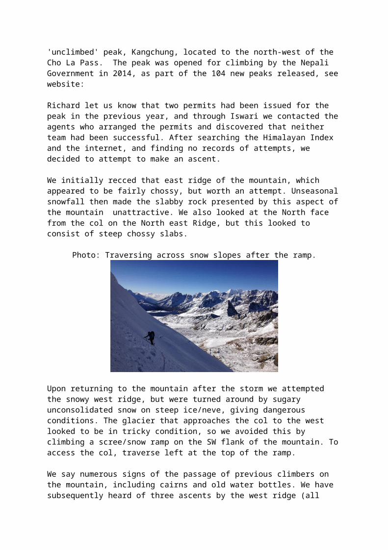
We initially recced that east ridge of the mountain, which appeared to be fairly chossy, but worth an attempt. Unseasonal snowfall then made the slabby rock presented by this aspect of the mountain unattractive. We also looked at the North face from the col on the North east Ridge, but this looked to consist of steep chossy slabs.
Photo: Traversing across snow slopes after the ramp.
Upon returning to the mountain after the storm we attempted the snowy west ridge, but were turned around by sugary unconsolidated snow on steep ice/neve, giving dangerous conditions. The glacier that approaches the col to the west looked to be in tricky condition, so we avoided this by climbing a scree/snow ramp on the SW flank of the mountain. To access the col, traverse left at the top of the ramp.
We say numerous signs of the passage of previous climbers on the mountain, including cairns and old water bottles. We have subsequently heard of three ascents by the west ridge (all without permits), and one attempt on a route from the glacier to the north.
Late 80's- 'Phil' soloed the West Ridge, finding easy snow slopes2006- Local guide and Lodge owner from Dragnag climbed the west ridge, apparent finding it very straightforward2013- An acquaintance of Jon's summited from the west.
2014- A Czech team were rescued by helicopter whilst attempting to climb from the north side of the mountain.
A note to future potential ascentionists- the rock on this peak appears to be of poor quality.
Photo: Kanshung (Right) from the south.

Photo: the glacier to the West of Kangshung.Kyajo Ri 6186m
The North ridge looked like a really good unclimbed objective, so we set our sights on the 900m face and sketched a line to the top. A recce a few days earlier found a technical ramp slanting up to the base of the hanging glacier.
Photo: Kyajo Ri from Machermo. The right hand skyline is the unclimbed north ridge.

We set off from Machermo (4400m) after an early lunch to camp at the base of the route (5250m), with the walk taking 3 hours. There is a small frozen lake with water running out through a stream, where we chose to camp. We employed two porters to carry our climbing equipment to this basecamp.
We used the same start that a Kiwi team took in 2011 on their attempt to climb the North East face, ascending steep ice to the foot of the hanging glacier. This involved two pitches of ice and mixed at around Scottish IV. This appears to be protected from serac fall by a steep rock buttress. From here we traversed left under the glacier, making use of overhanging rock walls to provide protection from ice fall. We justified this route choice as the overhanging rock offered some protection and we were only under the hanging glacier for a few minutes.
From here we ascended steep snow slopes to where it was possible to access the hanging glacier. This proved to be hard work, with deep, unconsolidated snow slowing progress. From the hanging glacier we climbed up a snow couloir to a rock band, which was climbed at VS. From here another pitch of steep snow led to where we chopped a ledge big enough for
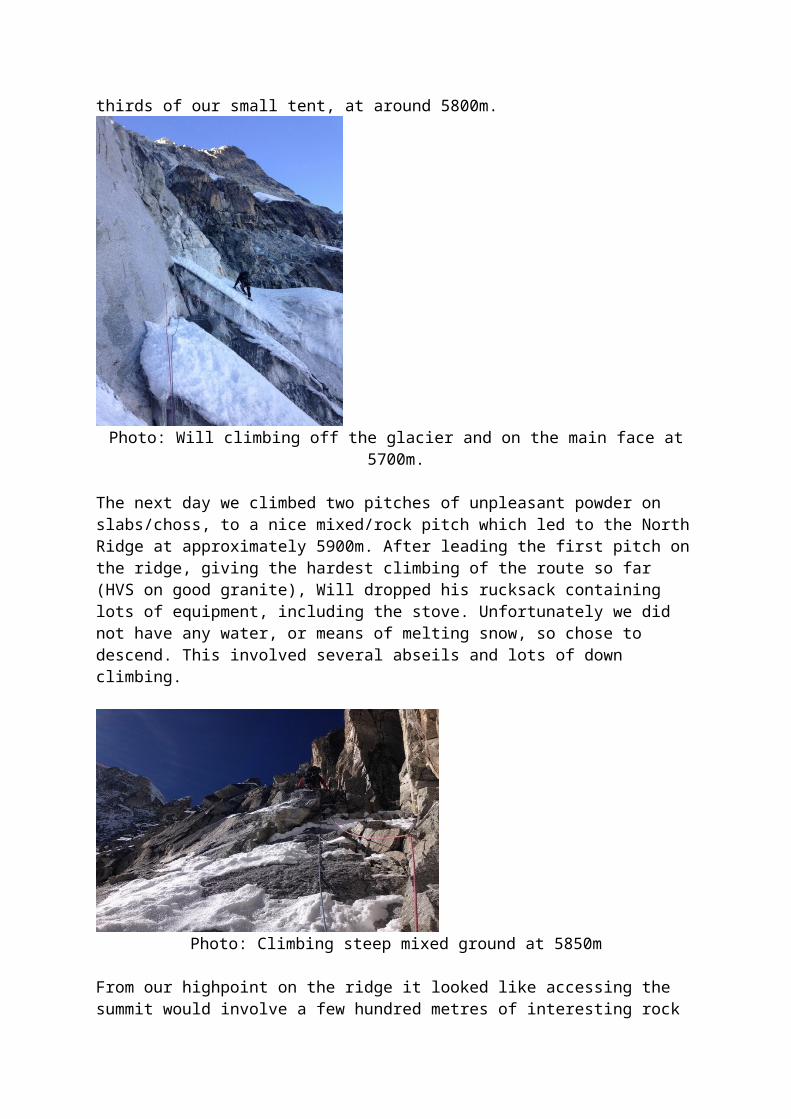
two-thirds of our small tent, at around 5800m.Photo: Will climbing off the glacier and on the main face at 5700m.
The next day we climbed two pitches of unpleasant powder on slabs/choss, to a nice mixed/rock pitch which led to the North Ridge at approximately 5900m. After leading the first pitch on the ridge, giving the hardest climbing of the route so far (HVS on good granite), Will dropped his rucksack containing lots of equipment, including the stove. Unfortunately we did not have any water, or means of melting snow, so chose to descend. This involved several abseils and lots of down climbing.

Photo: Climbing steep mixed ground at 5850m
From our highpoint on the ridge it looked like accessing the summit would involve a few hundred metres of interesting rock ridge, possibly using ledge systems on the NE face to skirt gendarmes. From approximately 6050m it would be possible to move around onto steep snow slopes on the west face which should lead to the summit with greater ease. This should be possible, and would probably give an overall alpine grade of TD/ED, and would be a worthwhile objective for a future expedition.
Lobsang, the lodge owner who we stayed with in Machermo, told us that in the pre-monsoon season the North-East face is often much drier. The rock on the route that we tried was generally pretty good, but elsewhere on the mountain it looked much chossier.
It is worth noting that on Google earth it looks like a ramp system below the sub-peak to the north of Kyajo Ri would give access to the North Ridge. In person this ramp looks to hit steep walls before reaching the Col, so would not provide easy access to the ridge.
Photo: Will climbing the first HVS/ A1 pitch at 5900m.
Machermo Ice climbs
We climbed four icefalls on the shady North-West aspect on the Machermo valley, up to 70m in length and at WI3 to WI4, located at approximately 4750m. We also attempted a gully
starting at 5000m on the same aspect, which looked to give good Scottish style climbing. After 30m of climbing on this line we retreated in the face of scarily heavy spindrift. Lobsang Sherpa, from 'Lodge in Machermo' showed us pictures of other longer, steeper ice lines which form in the valley during winter, which look excellent and are unclimbed, as far as we are aware.
Photo: The main cliff band with many ice falls. North East facing.
Photo: The south-west facing cliff band with water marks of the icefalls. 150M+.

Photo: Jon leading one of the waterfalls at WI3+
Mountain Observations
PharilapchaWe had hoped to attempt a route on Pharilapcha, but unfortunately this mountain appeared to be much drier than in Photo's we had seen from previous years. The North Face was covered with powder when we arrived in Gokyo, but this soon sloughed off to reveal blank looking rocky sections on the unclimbed central line that we had hoped to attempt. Our experiences on the nearby Kyajo Ri make me think that the line would probably be more powder on steep rock than ice climbing- future parties considering an attempt on this unclimbed route should perhaps bear this in mind. The south face was particularly dry, and looked extremely chossy, with what appeared to be scree where previous ascentionists have found snow and ice.
Photo: Pharilapcha South Face
Notes
AgentWe used Himalayan Guides. Iswari Paudel who runs the company was very helpful. They collected us from the airport, arranged flights to Lukla, sorted out permits etc. Using an agent is relatively inexpensive and massively reduces faff.

PermitsWhen we arrived in Kathmandu the government had that day removed the authority to issue permits from the Nepali Mountaineering Association. This had caused a little chaos, and no permits were being issued. This was easily resolved by Iswari arranging permits fr us once we had left for the Khumbu, and emailed them through to us. This was very convenient, as it allowed us to gain permits for peaks once we had assessed conditions in person. Permits for peaks below 6500m are $125 per person in the post monsoon season.
On returning to Kathmandu Jon attended a debrief session at the ministry of tourism, involving answering a few questions about our climbs and signing numerous pieces of paper.
PortersPorters were organised as we went.
We sent our bags straight from Lukla to Lobuche. This was organised through Paradise Lodge in Lukla, 6 days at 1400 Rs a day.
We sent one bag from Lobuche to Gokyo, one to Kangchung BC- 5000Rs per porter. This was pre-organised by Kame Nuru Sherpa in Pangboche
From Gokyo to Machermo with one porter (heavy bag) was 2000Rs One bag was transported from Dragnang to Machermo by Yak, free of change by
Tashi the owner at Mountain Paradise Lodge. All bags were portered from Machermo to Lukla at 1400rs per day.
WeatherWith the exception of the three day snow storm we unluckily had during the middle of our trip the weather was generally very stable. Typically we had clear, crisp mornings followed by cloudy afternoons. It got noticably colder towards the end of our trip.
GasWe purchased gas canisers (750 Rs each) from Kame Nuru Sherpa, a logistics organiser in Digboche. Canisters can also be purchased in Lukla or Namche.
Internet and TelephoneInternet is widely available in Teahouses, for between 500-1000Rs a day. We purchased a Nepali Sim card and found sporadic service in the Khumbu Valley. A five minute call to a french mobile phone cost 25Rs!
Exchange rateIn Kathmandu the exchange rate was £1: 157 Rupees/ $1: 100 Rs
Tea HousesWe stayed in tea houses throughout our trip. These were cheap, averaging around $20 pp. Including all food. This gives a very luxurious experience compared to expeditions based in tents, but removes the attraction of enjoying a wilderness experience.
Tea Houses used:NamcheKyangjuma- Ama Dablam View Lodge- Good foodPangboche- Sonam Lodge- excellent Chicken ChiliDingboche- Green Inn/ Moma's Bakery- Very friendyLobuche- Peak 15- Very helpful and friendly

Zongla- Dragnang- Mountain Paradise- Warm, Modern placeGokyo- Fitz Roy Inn- Lovely place, highly recommended. Warm rooms, good food, hot showers etc.Machermo- The Lodge at Machermo- Nice place. The owner, Lobsang Sherpa, is knowledgable about local climbing and was very helpful. The Dal Baht with meat was the best in the Khumbu.Lukla- Paradise Lode. Really nice and linked with Iswari of Himalayan Guides. Helped sort out Lukla flights and airport faff.
Equipment
Tent: We carried a single skin tent to use whilst climbing. We borrowed a Rab Latok 3, which was perfect for this.
Stove: We used a Jetboil. Gas canisters are easily available. A home-made copper heat transferrer was used in cold weather.
Clothing: For peaks up to 6000m same as in the Alps in spring, with an extra warm layer. Jon’s clothing was supplied by Montane, Will used a mixture of brands.
Waste disposalWe ensured that all rubbish generated on climbs was carried back to be disposed of with other waste generated at teahouses.
Illness/ InjuriesNeither of us sustained any injuries, but we both came down with a cold & cough which forced us to take several rest days between attempting Kangshung and Kyajo Ri.
Expedition expenditure:
9. BudgetExpedition Costs £ Expedition Income £Travel to and from country 1200 Number of members:
21200
Travel within country: 575 Grants:BMC- 650MEF- 750Alpine Club- 350
1750Peak fees and Liaison Officer expenses if appropriate:
500
Porters: 220Food and accommodation in country: 1200Insurance costs: 200Miscellaneous (details and costs):Visas- 135Agent fee- 135
270 Other sources:
TOTAL: 4145 TOTAL: 4145