Embed Size (px)
Citation preview

1 Application Description

SUMMARY OF CHANGES
CategorySection
(Current Submission)Page #
(Dec 2015 Submission)Description of Change
Vision“Section 1.3 Vision: Healthy Community” on Page 16 n/a Vision statement inserted, including: Memory; Social Support & Engagement; Connectivity & Accessibility;
and Food Systems
Tree free root growth / Stormwater
“Section 1.6 Parking & Loading” on Page 24“Section 3.2.1 Urban Forestry Management Strategy (continued)” on Page 111“Section 3.4.5 Gateway Plaza” on Page 136
2095-99
n/a
Decreased area of underground parking footprints, especially below the High Street Commons and within Parcel H, to increase the amount of tree free growth and stormwater management area.
Precincts / Neighbourhoods
“Section 1.7 Design Rationale” on Page 28“Section 3.3.1 Neighbourhoods” on Page 115
25n/a
Defined two distinct precincts (neighbourhoods) within the plan, based on landscape treatment and building height / scale.
East-West Connection
“Section 2.4 Parcel C – Phase 1” on Page 62“Section 2.9 Parcel H – Phase 5” on Page 94
5683
Adjusted parcel boundaries of YMCA / CHC building to better align the east-west connector across the site. Redesign of Parcel H: created a gateway plaza at southeast corner of the parcel, tying to the central open space and providing opportunities for tree growth and stormwater management; and aligned sidewalk to east-west connection pathway for better visual and physical porosity.
Site Drama / Diversity “Section 2.8 Parcel G – Phase 4” on Page 86 76 Complete redesign of parcel, to create a diversity of open space sizes and uses.
Vision “Section 3.1 Open Spaces and Public Places” on Page 104 92 Project vision (see top row) elaborate as a key aspect of the open space concept.
Public Art “Section 3.1.1 Memory” on Page 105 n/a Defined possible locations for public art.
Site Drama“Section 3.3.2 Site Drama” on Page 116 n/a Included a section on the opportunities for drama across the site, as it relates to both the scale of open
space, building height, and open space design / opportunities.
Pearson Plaza / Community Heart
“Section 3.4.2 Pearson Plaza” on Page 121 102 Redesign of Pearson Plaza to include bosque of trees, kids play, and articulate how the space can accommodate different uses, including a farmer’s market.
High Street Commons
“Section 3.4.3 High Street Commons” on Page 125 101 Redesign of High Street Commons to create large planting area on the east side, capitalizing on the free root growth zone and providing a screen to the YMCA edge. Included small kids play area at south.
Urban Farm“Section 3.4.4 Urban Farm” on Page 128“Section Appendix C – Urban Farm Location Analysis” on Page 236
104Elaborated on the vision for the farm, and the 3 components: production, awareness & education.
Bicycle Network “Section 3.5.2 Bicycle Network” on Page 155 108 Included note regarding bike dismount, encouraged through signage and bike racks at key locations.
Cambie Street setback
“Section 3.6.4 Cambie Street” on Page 161 114 Incorporated two cross sections, to show both the north and south block condition for Cambie, incorporating the blue-green design principles of the Cambie Corridor Plan.
Building Heights“Section 5.2 Building Heights” on Page 174 134 Changed building heights, most notably: Parcel G tower G1 reduced to 16 stories to minimize farm
shadowing. The following buildings were increased in height: F2 from 23 to 24 stories; G7 from 11 to 12 stories; and H1 from 18 to 20 stories.
Stormwater Management
“Section 6.5.3 Stormwater Management Strategies” on Page 214 168Included locations for various storm water management strategies throughout the site.
YMCA / CHC Location “Section Appendix D – YMCA/CHC Location Analysis” on Page 240 n/a Included as reference.

Application Description
10 PEARSON DOGWOOD REZONING
1.1 Application Intent & Overview
1.1.1 IntroductionThe Onni Group, in partnership with Vancouver Coastal
Health, is pleased to submit to the City of Vancouver
the rezoning application for the 10.3 hectare (25.4 acre)
Pearson Dogwood site, located between Cambie and
Heather Streets, and 57th and 59th Avenues. The intent of
the application is to rezone the property from its current
RT-2 Zone to a CD-1 Zone to allow for the development
of a complete community with a full range of uses,
interconnected open space network, and robust mobility
network.
The proposed site master plan, developed by Lead
Consultant IBI Group and a team of local Consultants, was
based on the objectives and guiding principles as outlined
in the Pearson Dogwood Policy Statement, approved by
City Council in February of 2014. The proposed project
is also aligned to City of Vancouver public policies such
as the City’s Regional Context Statement of the Offi cial
Development Plan, the City’s Greenest Action Plan, and the
Rezoning Policy for Sustainable Large Site Developments.
1.1.2 Document OverviewThis document constitutes the rezoning application for the
Pearson Dogwood site, including all pertinent material for
the City of Vancouver to make an informed assessment of
the site master plan proposal and of its key components.
The rezoning application is supplemented with the Design
Guidelines, a more specifi c document for the individual
design of all future elements of the plan. The document is
organized in six sections:
1. Application Description – The fi rst section describes
the past context and proposed development for the
site, providing a narrative from the history of Pearson
Dogwood to the vision, design rationale and overview of
the proposed plan.
2. Development Phasing & Block Studies – This section
provides a description of the development phasing,
and details of the various development parcels by way
of typical plans, cross sections and 3D visualization, in
order to identify the specifi c layouts of each of the areas
of the plan.
3. Parks, Open Space and the Public Realm – The third
section focuses on the overall concept for the public
open space system. It includes the landscape plan, and
a description of the particular public open spaces and
mobility networks.
4. Private Open Spaces – This section focuses on the
transitional open spaces between the public and private
realms, including at-grade patios, arrival courts, and
interior courtyards. In addition, it describes fully private
common open spaces.
5. Built Form – This section describes the different
aspects of the proposed built environment, including
building uses and heights, coverage, setbacks,
massing, site-wide cross sections, shadow studies,
and view studies.
6. Sustainability Measures – This section describes the
specifi c targets and actions (physical components and
operational measures) that are proposed to align the
development with the Greenest City 2020 objectives.
Central
Northwest

Application Description
PEARSON DOGWOOD REZONING 11
1.1.3 Proposed Density & UsesThis requested new zoning consists of a gross fl oor space
ratio (FSR) of 2.8, including:
• Market Housing – multiple 3- to 28-storey residential
buildings that contain units of various sizes and
typologies for market housing;
• Pearson Housing Units with Supports – 114
replacement residential units for existing Pearson
residents, which will be dispersed throughout the site as
either independent or clustered units, offering various
levels of support depending on client needs;
• Affordable Residential – target of 20% of all residential
units will be below market dispersed throughout the
site, roughly half of which will be at BC Housing Income
Limits (HILs) rent levels, with the remainder as market
rental and the possibility for affordable ownership;
• Complex Residential Care – a new leading practice
residential care in a new purpose-built facility that
will provide 24-hour professional nursing care and
supervision in a protective, supportive environment for
clients with signifi cant health issues;
• Community Health Centre – a new Integrated
Community Health Centre for Community Health Area
6, which will offer client care that is coordinated and
personalized, where the intensity of service is dynamic
and aligns with client and family needs; and
• Retail – up to 13,935 square metres (150,000 sq.ft) of
local-serving retail uses, including a full size grocery
store.
In addition, the plan includes the following uses, which are
excluded from the overall gross fl oor area:
• YMCA – A new expanded YMCA facility that replaces
the Langara YMCA located at 49th Ave. and Alberta St.
• Therapeutic Pool – A replacement to the Stan Stronge
Pool, which will be co-located with the YMCA pools;
• 69 Space Child Daycare – A new infant to preschool
aged daycare, located atop the YMCA facility;
• Adult Daycare – A new adult daycare located on the
ground fl oor of a Complex Residential Care facility.
• Urban Farm Infrastructure – Sheds and enclosed farm
related buildings.
Defi nitions to be added to the CD-1 Zoning Bylaw
Adult Daycare (ADC) Facility – means the use of premises
to provide essential social supports and preventative health
services to at-risk adults living in their own homes. The term
Adult Daycare is synonymous with ‘Adult Daycare’ and ‘Adult
Day Centre’.
Discovery Centre – means a temporary, purpose built
building to provide information to surrounding residents
regarding the development, and to market and sell
residential units. The Discovery Centre will be constructed
in Phase 1 of the overall development and maintained
throughout the development of the overall site, with
demolition to allow for the construction of the last buildings
on-site.
1.1 Application Intent & Overview cont’d
1.1.4 Rezoning RationaleThe zoning regulations proposed to be included in the CD-1
Bylaw and justifi cation are included in Section Table 1-1
through Table 2-2. Proposed parking and loading regulations
are indicated in Section 1.6.
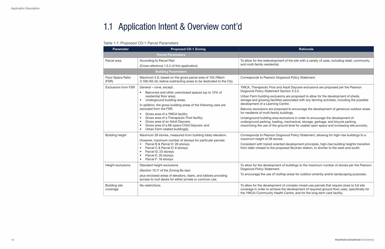
Application Description
12 PEARSON DOGWOOD REZONING
Parameter Proposed CD-1 Zoning Rationale
Parcel Parameters
Parcel area According to Parcel Plan
(Cross reference 1.5.2 of this application)
To allow for the redevelopment of the site with a variety of uses, including retail, community,
and multi-family residential.
Building Parameters
Floor Space Ratio
(FSR)
Maximum 2.8, based on the gross parcel area of 102,766sm
(1,106,165 sf), before subtracting areas to be dedicated to the City.
Corresponds to Pearson Dogwood Policy Statement.
Exclusions from FSR General – none, except:
• Balconies and other unenclosed spaces (up to 12% of
residential fl oor area).
• Underground building areas.
In addition, the gross building areas of the following uses are
excluded from the FSR:
• Gross area of a YMCA facility;
• Gross area of a Therapeutic Pool facility;
• Gross area of an Adult Daycare;
• Gross area of a 69-space Child Daycare; and
• Urban Farm related building(s).
YMCA, Therapeutic Pool and Adult Daycare exclusions are proposed per the Pearson
Dogwood Policy Statement Section 3.2.5.
Urban Farm building exclusions are proposed to allow for the development of sheds,
storage and growing facilities associated with any farming activities, including the possible
development of a Learning Centre.
Balcony exclusions are proposed to encourage the development of generous outdoor areas
for residents of multi-family buildings.
Underground building area exclusions in order to encourage the development of
underground parking, loading, mechanical, storage, garbage, and bicycle parking,
maximizing the use of the ground level for usable open space and increasing site porosity.
Building height Maximum 28 stories, measured from building lobby elevation.
However, maximum number of storeys for particular parcels:
• Parcel B & Parcel H: 26 storeys
• Parcel C & Parcel D: 6 storeys
• Parcel G: 23 storeys
• Parcel E: 20 storeys
• Parcel F: 18 storeys
Corresponds to Pearson Dogwood Policy Statement, allowing for high-rise buildings to a
maximum height of 28 stories.
Consistent with transit oriented development principles, high-rise building heights transition
from taller closest to the proposed Skytrain station, to shorter to the west and south.
Height exclusions Standard height exclusions
(Section 10.11 of the Zoning By-law)
plus enclosed areas of elevators, stairs, and lobbies providing
access to roof decks for either private or common use.
To allow for the development of buildings to the maximum number of stories per the Pearson
Dogwood Policy Statement.
To encourage the use of rooftop areas for outdoor amenity and/or landscaping purposes.
Building site
coverage
No restrictions To allow for the development of complex mixed-use parcels that require close to full site
coverage in order to achieve the development of required ground fl oor uses, specifi cally for
the YMCA / Community Health Centre, and for the long-term care facility.
Table 1-1: Proposed CD-1 Parcel Parameters
1.1 Application Intent & Overview cont’d

Application Description
PEARSON DOGWOOD REZONING 13
Outright Uses
Proposed CD-1 Zoning Rationale
Accessory Uses Agriculture Uses• Nursery, Field Crop or Fruit Farm
• Community Garden
Cultural and Recreational Uses• Fitness Centre
• Park or Playground
• Swimming Pool
Dwelling Uses• Multiple Dwelling
• Senior Supportive or Assisted Housing
Institutional Uses• Adult Daycare Facility
• Ambulance Station
• Child Daycare Facility
• Community Care Facility
• Group Residence
• School - Elementary or Secondary
• School - University or College
• Social Service Centre
Offi ce Uses• Financial Institution
• General Offi ce
• Health Care Offi ce
• Health Enhancement Centre
Retail Uses• Grocery of Drug Store
• Liquor Store
• Neighbourhood Grocery Store
• Retail Store
• Small-scale Pharmacy
Service Uses• Barber Shop or Beauty Salon
• Beauty and Wellness Centre
• Laboratory
• Laundromat or Dry Cleaning Establishment
• Neighbourhood Public House
• Restaurant
• School - Arts or Self-Improvement
• School - Business
Proposed outright uses will allow for the development of
a comprehensive, mixed use development as envisioned
through the development of the Pearson Dogwood Policy
Statement.
Selected Specifi c Use Rationale:
• Nursery, Field Crop or Fruit Farm – to allow for the
development of a large ~1 acre farm central to the site
that may include crop production.
• Group Residence – to allow for the development of
the Pearson Unit as the Green House model or Group
Home model.
• Laboratory – to allow for the possible development of
supporting laboratory services on-site, in conjunction
with the Community Health Centre
• School (Institutional and Service Uses) – to allow for
education, employment, immigrant training programs,
and social service programs associated with the YMCA.
In addition, to allow for the development of a farm-
related education centre.
• Retail & Service Uses – to allow for the development
of a comprehensive mix of retail and service uses that
will meet current and future needs of residents over
time.
Table 1-2: Proposed CD-1 Permitted Uses (Outright & Conditional)
Conditional Uses
Proposed CD-1 Zoning Rationale
Agriculture Uses• Greenhouse
Cultural and Recreational Uses• Artist Studio
Dwelling Uses• Micro Dwelling
Manufacturing Uses• Bakery Products Manufacturing
• Clothing Manufacturing
• Wood Products Manufacturing
Offi ce Uses• Discovery Centre
Retail Uses• Farmers’ Market
• Medical Marijuana-related Use
• Public Bike Share
Service Uses• Hotel
• Photofi nishing or Photography Laboratory
• Print Shop
Utility and Communication Uses• Public Utility
Proposed conditional uses will allow for the development
to respond to market changes, while still maintaining the
integrity of the plan as a Health, retail and housing oriented
development.
Selected Specifi c Use Rationale:
• Greenhouse – to allow for the development of
greenhouse building(s) as a component to the urban
farm, either as providing space for starting seeds or the
production of crops.
• Clothing Manufacturing – to allow for the possible
development of small-scale clothing manufacturing
facilities in conjunction with retail uses. The
manufacturing component would be secondary to retail
uses.
• Wood Products Manufacturing – to allow for the
possible milling of existing trees on-site, which may
be used as elements within the public realm or for the
construction of buildings on-site.
• Discovery Centre – to allow for the long-term
education and marketing of the development for
existing and surrounding residents, and prospective
home owners.
• Hotel – to allow for the possible development of a hotel,
given the strategic location of the site on the Canada
Line.
• Photofi nishing or Photography Laboratory – to allow
for the development of a photofi nishing laboratory as a
component of a pharmacy or grocery store.
• Public Utility – to allow for the development of a district
energy facility, or similar utility that meets the energy,
recycling, composting or other utility needs of uses on
the Pearson Dogwood site.
1.1 Application Intent & Overview cont’d

Application Description
14 PEARSON DOGWOOD REZONING
Pearson Dogwood site is on Musqueam Nation traditional lands
Pearson Dogwood, © http://www.pearsonresidents.org/ Sir Winston Churchill Secondary School Langara Golf Course
1.2 Site ContextThe Pearson Dogwood site is located on the northern
edge of the Marpole Neighbourhood, approximately 7 km
from downtown Vancouver and 5 km from the Vancouver
International Airport (YVR).
Historical ContextThe Pearson Dogwood site is part of the traditional lands
of the Musqueam First Nation. The property was fi rst
developed for institutional health care uses in the 1950s,
serving clients with physical disabilities and seniors needing
long-term residential care. There are currently two main
facilities on the site: the George Pearson Centre and the
Dogwood Lodge.
George Pearson Centre was constructed in 1952 as a
tuberculosis sanatorium and was subsequently used during
the polio epidemic in the 1950’s. The centre is now home
to 114 adult residents who live with a range of physical
conditions such as multiple sclerosis, spinal cord injuries,
traumatic brain injuries, and cerebral palsy. Dogwood Lodge
was constructed in 1974 as an intermediate care facility. The
lodge is home to 113 seniors, many of whom are living with
Alzheimer’s disease. Residential care is provided to people
who have complex care needs, can no longer remain safely
in their homes, and require 24-hour on-site nursing care.
Existing ContextThe site is strategically located within the City of Vancouver.
It is bounded by Cambie Street to the east, Heather Street
to the west, 57th Avenue to the north and 59th Avenue to the
south. The facilities and uses in immediate proximity to the
site are shown in Figure 1-1.
Mobility & Access
The site has excellent access by way of bike routes (Heather
Street and the 59th Avenue), transit (bus route 15 and N15,
which provides service north/south along Cambie), and
vehicular access on all sides. The site is located roughly
800 metres from two Canada Line stations: 49th Avenue –
Langara Station to the north, and Marine Drive Station to the
south.
Recreation and Commercial Amenities
There are numerous community amenities and facilities
within immediate proximity to the site. Sir Winston Churchill
Elementary and Secondary Schools, and the Ideal Mini
School are located to the west and northwest, and include
fi elds, running track, playgrounds and other outdoor
facilities.
The Langara Golf Course, a City of Vancouver owned
and operated facility, is located across Cambie Street,
and includes a 2.7 km perimeter walking trail. In addition,
Oak Park (~250 m southwest) and Winona Park (~150 m
southeast) are within a fi ve minute walk of the site, and
include additional fi elds, playgrounds, an outdoor hockey
rink, sports courts and the Marpole Oakridge Community
Centre.
The YMCA is located nearby on W 49th and Alberta Street,
and offers recreational services, attracting people from the
local neighbourhood and beyond.
Additionally, there are numerous commercial and institutional
uses that complement the wealth of recreational facilities
located nearby the site. Langara Gardens, which lies
directly to the north, contains retail stores offering health
and fi nancial services. Additional retail and offi ce uses are
located at Oakridge Centre, located on Cambie Street and
W 41st Avenue, approximately 1.5km to the north, and many
large-format retailers along Marine Drive to the south. Lastly,
Langara College is located along 49th Avenue, roughly 1km
to the northeast.
Additional Surrounding Land Uses
The remaining lands surrounding the site are residential.
The lands to the south, east and west are comprised of
established single family residential, while a large multi-
family residential development (Langara Gardens) is located
to the north, which includes a mixture of rental townhomes
and highrise apartments.
Existing Policy & Future Land Uses
The site falls along the Cambie Corridor, which has
undergone extensive policy analysis and review, as outlined
in the 2011 Cambie Corridor Plan. The Plan allows the the
buildings along the corridor south of the development to
be up to 6 stories tall, with a mixture of residential and
commercial uses, depending on location.
In addition, the Langara Gardens are currently being
reviewed with the intent to create a Policy Statement that
will guide future development of that site, which is intended,
in conjunction with the Pearson Dogwood site, to form the
second part of a community centre, focused around the
proposed transit station at 57th Avenue and Cambie Street.

Application Description
PEARSON DOGWOOD REZONING 15
Pearson Dogwood site
Canada Line
Proposed Station at W 57th Ave & Cambie St.
Bike Routes – Protected/Painted Bikeway
Bike Routes – Local Street Bikeway
North Arm Trail Greenway
Langara Gardens
Parcels affected by the Cambie Corridor Plan
Parks
Open Spaces
Community Gardens
Urban Farm
Schools
Libraries
Hospitals
Community Centres
Recreational Programs
Cultural Spaces
Places of Worship
W. 49th Ave.
W. 50th Ave.
W. 51th Ave.
W. 52th Ave.
W. 53th Ave.
W. 54th Ave.
W. 48th Ave.
W. 47th Ave.
W. 46th Ave.
W. 55th Ave.
W. 56th Ave.
W. 57th Ave.
W. 58th Ave.
W. 59th Ave.
W. 62nd Ave.
W. 64th Ave.
Park Dr.
Cart
ier
St.
Bir
ch S
t.
Mo
ntc
alm
St.
Hu
dso
n S
t.
Selk
irk S
t.
Osle
r S
t.
Oak S
t.
Sh
au
gh
ne
ssy S
t.
Fre
mlin
St.
Lau
rel S
t.
Heath
er
St.
Ash S
t.
Cam
bie
St.
Figure 1-1: Site Context Map

Application Description
16 PEARSON DOGWOOD REZONING
Pearson Dogwood Policy Statement Vision
With a history of long-term health care on the property, the
planning process has strived to envision a new community
through a lens of “whole health”. Whole Health is defi ned as
“whole people, whole communities and whole ecologies”. The
Pearson Dogwood site will become a complete community
which meets the City of Vancouver’s objectives around
environmental, economic and social sustainability.
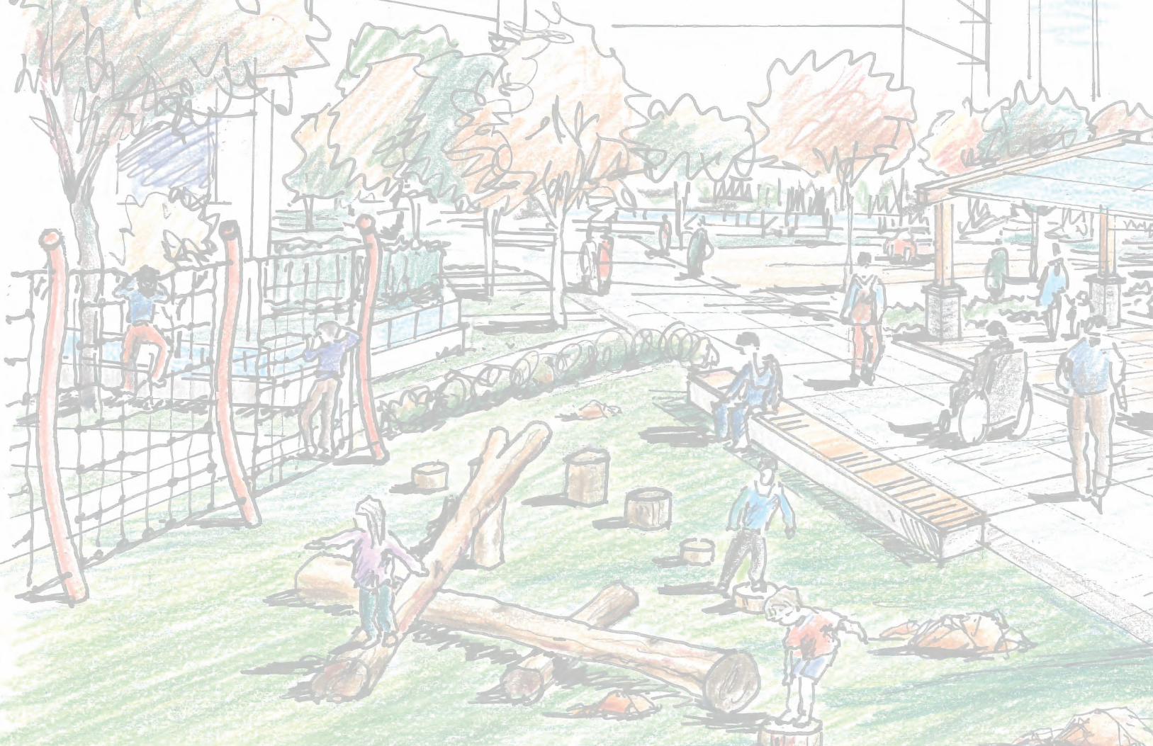
1.3 Vision: Healthy Community
Figure 1-2: Central Open Space & Urban Farm
The vision for Pearson Dogwood is for a model Healthy
Community, which will be manifested in four key strategies:
1. Memory – A Healthy Community starts with
understanding the existing site context and condition, as
well as the needs of existing (and future) residents. The
development will preserve the legacy of the site through
designing buildings, facilities and open spaces that
refl ect and build upon the history of the site, including
the needs of Pearson and Dogwood residents and care
workers, as well as relocating the existing urban farm,
designing the open spaces to respond to and emphasize
existing grades, and incorporating existing materials into
site design. Open spaces will refl ect Musqueam heritage
through public art, native plant species and other
landscape elements.
2. Social Support and Engagement – A Healthy
Community strengthens and supports social capacity
and neighbourliness through providing a variety of open
spaces, land uses and housing types where residents
of all ages, backgrounds and abilities will be able to
come together, meet one another, and build long-lasting
support networks and friendships.
3. Connectivity & Accessibility – A Healthy Community
prioritizes non-motorized accessibility and safety by
minimizing vehicular traffi c through the site and providing
multiple pathways for pedestrian and wheelchair use.
Connecting the site to the broader community will
ensure residents and visitors of all ages and abilities feel
welcome to explore and enjoy the new neighbourhood.
4. Food Systems – A Healthy Community is one in
which growing, preparing and eating food together
will build community resilience through promoting
food security, healthy ecosystems and nutrition, and
bringing neighbours together. This will be accomplished
through developing the full spectrum of food-related
facilities, including a new production-based urban farm
and education centre, community gardening plots,
therapeutic gardening, edible landscaping and spaces
for neighbours to prepare and eat food together.
Application Description
PEARSON DOGWOOD REZONING 17
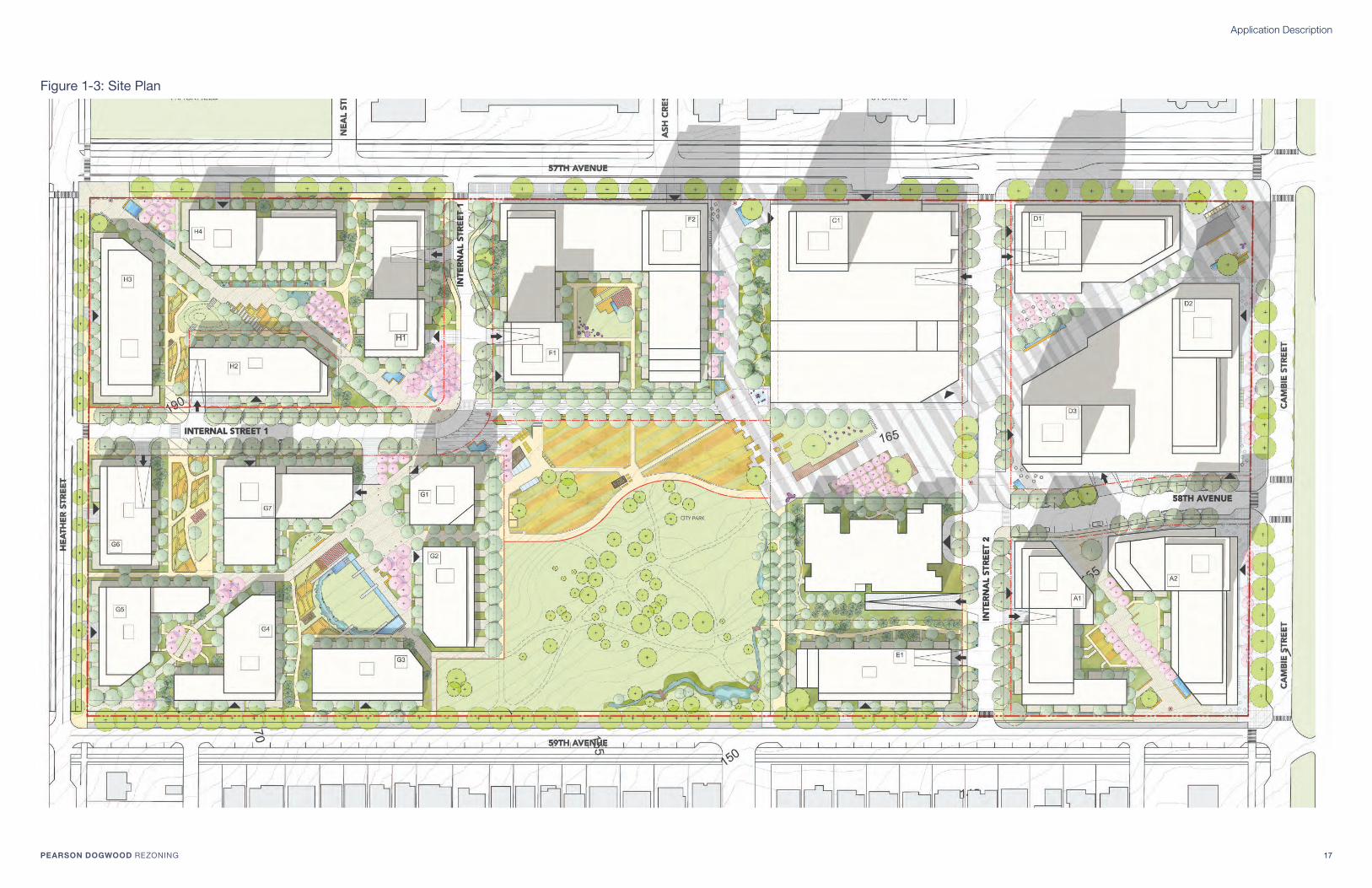
Figure 1-3: Site Plan

Application Description
18 PEARSON DOGWOOD REZONING
Dogwood Lodge Pearson Residents & Pool
Throughout the public realm, areas that facilitate social
interaction and allow for residents and visitors to gather and
meet will be provided with the intent of promoting social
interactions and strengthening social cohesion and support,
especially for vulnerable populations, but also including new
immigrants and others:
Primary areas:
- Major open spaces & activity nodes
- Central open space gateways
- Large, parcel-level gathering spaces
Secondary areas:
- Gateway Plazas
- Gardening plots
- Smaller, more intimate parcel-level gathering spaces
- Wellness Paths
Urban Farm Existing Trees
1.3.1 Vision: Memory
1
3
2 2
2
2
2
55
5
55
5
5
4
5
5
Refl ecting on the memory of the site includes understanding
the existing residents’ and health care workers’ needs and
emphasizing the existing natural and programmatic features
currently on-site.
The memory of the site is refl ected in fi ve strategies:
1. Dogwood Lodge Replacement
2. Pearson Residents Replacement
3. Stan Stronge Pool Replacement
4. Urban Farm Replacement
5. Existing Trees Retention & Relocation
The redevelopment will deliver a new model of health and
wellness that includes replacement facilities (Pearson Units,
Dogwood replacement, Stan Stronge Therapy Pool), but also
extends beyond the delivery of care to include healthy and
rejuvenating spaces throughout, and features that promote
the health and well-being for all, including disabled and
aging populations.
Natural and programmatic elements that are preserved and/
or relocated include the existing urban farm and trees. In
addition, the plan includes pathways, benches and other
open space elements that emphasize and reinforce the
existing gently sloping grades, while providing several key
accessible, virtually fl at pathways that take advantage of the
grades to cross the entire site.
Native and new plantings will encourage a vibrant ecosystem
that provides habitat for birds, pollinators and other animals.
Musqueam heritage will be incorporated as the designs of
the open spaces progress.
1.3.2 Vision: Social Support and Engagement
Figure 1-4: Memory Elements Throughout Figure 1-5: Areas for Social Support and Engagement

Application Description
PEARSON DOGWOOD REZONING 19
Pedestrian and Wheelchair Priority is achieved through:
Wellness Zone: Creating a large, contiguous car-free
zone in the middle of the site with a diversity
Car-fee courtyards
Connectivity is achieved through Pedestrian &
Wheelchair Accessible Pathways
1.3.3 Vision: Connectivity & Accessibility 1.3.4 Vision: Food Systems
The relocation of the Urban Farm to a central location
creates a hub for food production, education and capacity
building. Food will be further reinforced with community
garden plots, edible landscaping and interactive / learning
elements.
Active Food Production Zones:
- Urban Farm
- Community Gardens
Passive Food Production / Awareness Zones:
- Edible landscaping
- Orchards
- Art and/or other awareness elements
Figure 1-6: Major Connections and Accessible Open Spaces Figure 1-7: Food Production Throughout

Application Description
20 PEARSON DOGWOOD REZONING
Pearson Dogwood Policy Statement Complete Community
Pearson Dogwood will be home to people of different
incomes, ages and abilities; have good access to transit, jobs
and services; and be well served by community amenities
and health facilities such as a Community Health Centre, a
therapeutic pool, childcare and recreational facilities. These
amenities will help create a social heart for the site and provide
for existing and future needs. The community will be highly
accessible and provide a spectrum of housing options with
a target of achieving 20% of all units as affordable housing.
All affordable housing units will be rental, comprised of family
and non-family units and secured with a Housing Agreement.
Health-related housing for persons with disabilities and frail
seniors will be based on best-practice worldwide and designed
in consultation with the respective communities
1.4 Plan Description & Goals
Plan Description
The proposed site master plan embodies the principles
of Complete Community planning, intertwining health,
recreation, retail, and employment uses with housing
diversity and affordability.
At the heart of the development is an extensive park and
open space system, which includes: a new 2.5 acre City
Park (to be designed later through a City-led process); a 1
acre urban farm; the large Pearson Plaza; the High Street
Commons, a north-south open space that ties the Pearson
Dogwood site to Langara Gardens to the north; and the
Cambie Walk retail plaza, which extends from the central
open space area to the proposed transit station at 57th
Avenue and Cambie Street.
In addition, the open space network is complemented by
diagonal pathways through the development blocks in all
four corners of the site, providing excellent porosity and
movement to and from the proposed transit station to the
northeast, the Cambie Corridor, and schools and recreation
facilities to the west.
Housing affordability and diversity will be a hallmark of
the Pearson project, integrating a variety of people with
differing incomes and abilities throughout the site. Affordable
and accessible housing units will be included in multiple
buildings across the site, with almost half of the replacement
units for Pearson residents included in phase 1. In addition,
a new 144- bed Complex Residential Care facility will be
developed for residents with signifi cant health care needs.
In addition to affordable housing, market housing will include
a signifi cant number of larger units (2 and 3 bedrooms),
appropriate for families with children. Opportunities for
improving affordability of market units will be explored,
which may include providing units with modest fi nishes.
Amenities for new residents and the surrounding community
will be plentiful, creating a community and social hub that
will extend well beyond the project boundary. A primary
component of the amenities includes new health facilities:
a Community Health Centre, serving the health needs
of all residents in south Vancouver; an Adult Daycare,
which will provide a range of health, social stimulation and
therapeutic recreational programs; and a new Therapeutic
Pool, replacing the existing Stan Stronge Pool. In addition,
the ‘health’ aspect of the plan is interwoven throughout the
various programmatic elements, including:
• Possible areas of solitude and contemplation in the new
City Park;
• A large car-free wellness zone and additional walkways
throughout the site, ensuring all residents, despite
mobility challenges or preferences, can experience the
outdoors in a safe, accessible and secure environment;
• A new YMCA facility, which will provide options for
health and fi tness for residents in the greater community;
• Gardening in community garden plots on development
parcels, as well as therapeutic gardening for residents
with disabilities as part of the new urban farm;
• Healthy food options could be a component of the new
urban farm production, supplying Vancouver Coastal
Health, the YMCA or other facilities;
• Edible landscaping, which will provide food options
for residents while increasing awareness about what
types of food are available during the growing season in
Vancouver’s coastal climate;
• A Community Kitchen, which will allow residents and
neighbours the ability to come together to create and share
healthy meals, provide food for those who are less fortunate,
while also learning about healthy food options; and
• Possible opportunities for farming mentorship / education
as a component of the urban farm, which could extend
to nearby schools, specifi c user groups and/or the
general public to increase food security and awareness
throughout the neighbourhood and beyond.
Furthermore, social health and well-being will be increased
through the programming of the various open spaces,
providing a variety of options for residents to meet one
another, and come together to socialize and learn about
each other’s cultures, with the intent of decreasing social
exclusion and enhancing social support networks.
A 69-space Child Daycare will be included atop the new
YMCA facility, providing a local option for families to ensure
their young children are well cared for in close proximity to
their homes. The child daycare will have immediate access
to rooftop outdoor play areas, as well as the ability to access
the adjacent open spaces in a safe, car-free environment.
Lastly, the plan includes a signifi cant amount of local-serving
retail, including a proposed grocery store, which will provide
shopping and service amenities for new residents and those
surrounding the site.
Taken together, the plan represents a complete and healthy
community, with opportunities for residents to work, shop
and play right outside their front door, in a safe, pedestrian-
oriented environment.
Goals
In order to achieve the redevelopment vision, 6 goals were
developed that guided the development and refi nement of
the plan, as indicated below:
Parks & Open SpacesProvide an expansive and interconnected network of
open spaces, with a variety of sizes, functions and
programs that will encourage social interaction, and
allow all to access nature and lead healthy, and socially
rich lifestyles.
Health Services & Community Amenities Provide world-class health facilities and services,
and appropriate community amenities, which when
combined with the open space network, will ensure
Pearson Dogwood is a destination for health and
wellness.
Housing DiversityEnsure the project provides housing options for all
incomes and abilities in a variety of forms and tenures,
creating an inclusive community where neighbours can
get to know and support one another.
Food Production & Edible LandscapingIncorporate food production and edible landscaping
throughout the development, promoting food security
and allowing for space where people of all ages and
abilities can grow, prepare and/or eat food together.
Mobility & AccessibilityPrioritize safe pedestrian and wheelchair mobility
internal to the site; connect with the surrounding
neighbourhood; ensure bike facilities are available for
all ages and abilities surrounding the site; and provide
space for a future transit station and bus route.
SustainabilityCreate a complete community that is socially,
economically and environmentally sustainable.

Application Description
PEARSON DOGWOOD REZONING 21
Food ProductionOpportunities for Community Gardens
MobilitySeparated,
protected bike
facilities
MobilitySeparated, protected
bike facilities
Park & Open Spaces2.5 acre City Park
Park & Open SpacesPearson Plaza
SustainabilityRetained Existing
Trees
SustainabilityLegacy Trees
SustainabilityRetained Existing
Trees
SustainabilityRetained Existing Trees
HousingPearson & Affordable Housing in Phase 1
HousingPearson & Affordable Housing in Phase 2
Food ProductionOpportunities for
Community Gardens
Housing & HealthComplex Residential
Care Facility
Park & Open Spaces; Food Production
Urban Farm & East-
West Connecting Spine
Food ProductionOpportunities for Edible
Landscaping
Health & HousingCommunity Health
Centre, YMCA &
Pearson Units
HousingAffordable housing
MobilityProposed Transit Station & Bike Share
MobilityPedestrian & Wheelchair Accessible Path
MobilityPedestrian & Wheelchair Accessible Path
MobilityPedestrian linkages
through development
parcels

Application Description
22 PEARSON DOGWOOD REZONING
H
G
F C
B
E
D
A
Market Housing
Affordable Housing
Retail
69-space Child Daycare
Community Health Centre
YMCA
Residential Complex Care & Adult Daycare
Property Line
Parcel Boundary
1.5 Land Use Plan & Overall Development StatisticsPearson Dogwood Policy Statement
Relevant Policies3.2.1 Housing
• Integrate affordable housing and supportive housing units
throughout the site.
3.2.2 Retail and Commercial Uses
• Retail should be local-serving in character. Commercial
offi ce spaces would enhance and complement the retail.
3.2.3 Parks and Open Space (incl. Policy 5.2.1)
• A 1.01 hectare (2.5 acre) City park will be built around existing
mature trees and other landscape features.
• A public plaza should be provided in the vicinity of local-
serving health-care, recreational and retail/commercial uses.
3.2.5 Health Care: Housing & Services
• Community Health Centre (CHC) in close proximity to
transit and open spaces
• Adult Daycare in close proximity to the CHC
4.2.1 Health & Wellness
• Principles of universal design applied in the design of all
buildings, residential units, and public areas.
4.2.4 Transit Orientation
• Focus a higher level of activity, energy and height along W. 57th
Avenue towards Cambie and the new Canada Line Station.
4.2.5 W. 57th Avenue: Great Street
• Build on W. 57th Avenue as a great street, knitting Pearson
Dogwood and Langara Gardens.
• Reinforce existing neighbourhood shopping located at
Langara Gardens.
Figure 1-8: Land Use Plan
Urban Farm
2.5 Acre City Park
Pearson Plaza
High
Street
Commons
57th Avenue
59th Avenue
Inte
rnal S
treet
2
Cam
bie
Str
eet
Heath
er
Str
eet
Future
Transit
Station
Site
The plan includes a variety of land uses, located around
a large (2.5 acre) City Park and community plazas / open
spaces, including: neighbourhood serving retail, which
includes a grocery store; a new Community Health Centre
(CHC); a YMCA and co-located therapeutic pool; a 69-space
Child Daycare; a Complex Residential Care, including an
Adult Daycare; and a mixture of replacement Pearson units,
market and affordable housing units dispersed across the
site.
The retail, commercial and institutional uses, as well as the
tallest residential buildings, are all located in close proximity
to the proposed transit station in the eastern portion of the
site and along 57th Avenue, creating a hub of activity, and
bolstering the pre-existing retail at Langara Gardens.
The YMCA, therapeutic pool and CHC have excellent
visibility and connectivity to transit along 57th Avenue (CHC)
and along the diagonal view axes from Cambie (YMCA).
The Child Daycare is located atop the YMCA facility, which
in combination with a proposed family centre and space for
community events, makes the development parcel a social
hub for health and leisure.
The Complex Residential Care facility and Adult Daycare
are located immediately to the south of the YMCA across
the Pearson Plaza, providing excellent visual and proximal
connectivity between the various health uses.
At the ground level, residential buildings will animate the
public realm with units facing streets/paths, including entry
doors and patios, some of which will be at the same level
of adjacent sidewalks and paths to ensure accessibility.
In those areas with ground fl oor retail, a regular rhythm of
retail units will be created, with wide, accessible sidewalks.
Paths and streets throughout the site are designed to be
accessible, with grades not to exceed 5% slope.
Internal Street 1

Application Description
PEARSON DOGWOOD REZONING 23
1.5 Land Use Plan & Overall Development Statistics cont’dTable 1-3: Total Site Area & FRS Table 1-4: Building Area by Parcel
Table 1-5: Estimated Unit Count by Parcel
NON-EXCLUDED EXCLUDED SUB-TOTALTOTAL
OVERALL (sf)Parcel
Market Housing (sf)
Affordable Housing (sf)
Supportive Housing*
(sf)Retail (sf) Health (sf)
Amenity (sf)**
Daycare (sf)***
Affordable Housing (sf)
Non-Excluded (sf)
Excluded (sf)
PARCEL A 308,569 109,523 36,616 23,557 7,678 478,265 7,678 485,943
PARCEL B 110,998 4,719 110,998 4,719 115,717
PARCEL C 177,975 3,184 9,740 66,516 86,254 9,298 257,415 95,552 352,967
PARCEL D 427,703 176,444 31,840 80,545 12,367 716,532 12,367 728,899
PARCEL E 76,279 76,279 76,279
PARCEL F 365,741 58,425 11,144 17,439 4,095 452,749 4,095 456,844
PARCEL G 504,932 3,980 508,912 508,912
PARCEL H 408,524 83,608 3,980 5,860 496,112 5,860 501,972
TOTAL AREA 2,269,723 428,000 90,744 131,281 177,514 86,254 14,017 30,000 3,097,262 130,271 3,227,533
MARKET HOUSING ESTIMATED UNIT COUNTTOTAL
AFFORDABLE HOUSING ESTIMATED UNIT COUNTTOTAL
SUPPORTIVE
Parcel 1-Bedroom 2-Bedroom 3-Bedroom Studio Units 1-Bedroom 2-Bedroom 3-Bedroom Pearson Units
PARCEL A 159 196 355 35 35 41 27 138 46
PARCEL B
PARCEL C 92 112 204 4
PARCEL D 220 271 491 56 56 67 44 223 40
PARCEL E 40 48 88
PARCEL F 189 229 418 19 19 22 14 74 14
PARCEL G 167 167 334 5
PARCEL H 135 135 270 26 26 32 21 105 5
TOTAL UNITS 700 1,158 302 2,160 136 136 162 106 540 114
FSR
SITE AREAALLOWABLE
FSR
TOTAL BUILDING
AREA*
102,765 m2
2.80287,745 m2
1,106,165 ft2 3,097,262 ft2
*Total Area does not include YMCA, Therapy Pool, Adult
Daycare and Child Daycare

Application Description
24 PEARSON DOGWOOD REZONING
Parkade pulled back to accommodate
stormwater and allow for the planting of
trees in native soil and legacy trees
Parkade pulled back to protect existing trees
Parkade held back to allow for proposed
transit station and to protect existing trees
Underground parking structure
Parking entrance (vehicular)
Parking and loading entrance
At-grade Handy Dart Drop-off
Loading at-grade
Property Line
Parcel Boundary
Figure 1-9: Parking Plan
Parking Description
Parking to accommodate the full requirements of the
residential, commercial and institutional uses is contained
in underground structures that are located within private
parcels. The structures are typically two to three levels.
Where there is a blend of uses, the commercial spaces are
typically located on the uppermost level for convenience,
while the residential spaces are located below.
While some parking lots extend to the edges of the parcels,
many others are held back from the edge of the parcel
boundary in order to preserve existing trees and provide
space for legacy tree growth and/or to accommodate
stormwater features. In some instances parking lots extend
under publicly accessible private open space that is part of
a private parcel. No underground parking is located within
publicly dedicated rights-of-way.
Access to parking structures is via ramps from either
new City streets or private drives. The ramps are located
strategically to minimize confl icts with pedestrian routes.
Where ramps and sidewalks cross, care has been taken to
ensure there are good sightlines between the two.
Temporary street parking spaces are provided on the
proposed new City streets; however, this is not counted
in meeting the requirements. This parking is for the
convenience of Park users and users of the various shops,
services and other amenities for short-term purposes.
Loading Description
Loading for all uses is located within private parcels, with
the exception of two Handy Dart drop-off spots for the CHC:
one on 57th Ave and another on the new street to the east.
In most cases, loading this is within underground structures,
while surface loading is provided on private driveways in the
western residential parcels. Commercial and institutional
loading is provided in underground structures in the quantity
and dimensions required by City bylaws. Buildings with less
than 100 units are not planned to have off-street loading
facilities, consistent with City policy. The location of loading
ramps has been carefully considered to minimize their visual
impact on the public realm and locate them near arterial or
collector streets to minimize truck travel on local streets.
1.6 Parking & Loading
59th Avenue
Internal Street 1
Inte
rnal S
treet
2
Cam
bie
Str
eet
Heath
er
Str
eet

Application Description
PEARSON DOGWOOD REZONING 25
1.6 Parking & Loading cont’d
Table 1-6: Proposed Parking Rates
Parking Parameters
Parameter Proposed CD-1 Zoning Rationale for Change
Market housing (multifamily)
parking
Minimum 1 space per one-bedroom unit
Minimum 2 space per two-bedroom unit
Market housing (multifamily)
visitor parkingAccording to Parking By-law n/a
Affordable residential parkingMinimum 0.5 spaces per unit
Maximum 1 space per unit
Minimum reduced based on future transit station, to encourage the use of alternative
modes of transportation.
Affordable residential visitor
parkingAccording to Parking By-law n/a
Complex Residential Care Minimum 80 spaces Reduced based on new, compact form and proximity to transit.
Community Health Centre Minimum 80 spaces, and a maximum of 120 spaces. Allows for the development of a complex, mixed-use facility.
A variance is required, as YMCA parking demand is not directly related to fl oor area, per
the bylaw. It is infl uenced by a multitude of factors: membership numbers, specifi c class
times, range of facilities available, synergies with the new density, access to transit, etc.
Opportunities to share parking with the Community Health Centre stalls during evenings
and weekends to be explored during detailed design.
YMCA Minimum of 80 spaces, and a maximum 125 spaces
69-space Child Daycare11 spaces, to be provided underground in close proximity to
elevator core access to Daycare.n/a
All other uses According to Parking By-law n/a
Loading Parameters
Parameter Proposed CD-1 Zoning Rationale for Change
Residential & Commercial usesOpportunities to share loading between uses and/or buildings
to be explored at detailed design.
Due to scale of development, mixing of uses and potential loading demands at different
times, opportunities to share loading are encouraged
YMCA, Community Health Care
Facility & Daycare2 Class B spaces; 1 Class A spaces
Loading spaces to be shared between the YMCA, Community Health Centre and
Daycare.
Handy Dart spaces provided on-street along 57th Avenue and the New City Street to
the east of the CHC. An additional Handy Dart drop-off is contemplated underground to
provide direct access to the Therapy Pool (See Appendix B).
Complex Residential Care 4 Class B spacesDesire to keep Class C vehicles off of local roads results in increased number of Class B
loading spaces to accommodate greater number of smaller trucks for deliveries.
All other uses According to Parking By-lawOpportunities to share loading between uses and/or buildings to be explored at detailed
design.
Bicycle Parking Parameters (Class A)
Parameter Proposed CD-1 Zoning Rationale for Change
All uses According to Parking By-law n/a

Application Description
26 PEARSON DOGWOOD REZONING
1.6 Parking & Loading cont’d
Table 1-7: Estimated Vehicular Parking by Use Table 1-8: Estimated Loading by Use
Table 1-9: Estimated Bicycle Parking
PARKINGTOTAL OVERALL
Parcel Residential* Retail Health Offi ce Daycare Amenity
PARCEL A 670 43 713
PARCEL B 38 63 10 111
PARCEL C 337 100 11 100 548
PARCEL D 942 276 1,218
PARCEL E 145 145
PARCEL F 736 32 768
PARCEL G 699 699
PARCEL H 630 630
TOTAL 4,159 351 138 63 21 100 4,832
* Total includes affordable housing and visitor stalls
LOADINGTOTAL OVERALL
Parcel Class A Class B Class C
PARCEL A 1 2 3
PARCEL B 3 3 6
PARCEL C 4 4
PARCEL D 5 2 7
PARCEL E
PARCEL F 2 2
PARCEL G
PARCEL H
TOTAL 4 16 2 22
BIKE PARKING – RESIDENTIAL BIKE PARKING – OTHER
Parcel Class A Class B Class A Class B
PARCEL A 616 6 4 6
PARCEL B 6 1
PARCEL C 255 6 44 22
PARCEL D 893 6 15 6
PARCEL E 110 6
PARCEL F 615 6 3
PARCEL G 418 6
PARCEL H 469 6

Application Description
PEARSON DOGWOOD REZONING 27

Application Description
28 PEARSON DOGWOOD REZONING
1.7 Design Rationale The proposed plan has been developed in order to adhere to
the development pattern and land use program envisioned
during the development of the Pearson Dogwood Policy
Statement, which was prepared with extensive staff and
public input, and was ultimately endorsed by Council.
The Policy Statement includes a Vision and Objectives for
the site, supplemented by a range of Policies covering the
following topics:
• Complete Community
• Open Spaces and Public Places
• Site Planning and Building Form
• Transportation and Circulation
• Sustainability and Green Infrastructure
Since the development of the Policy Statement, the
proponent team has met with City staff in numerous
workshops and meetings in order to develop the proposed
plan and ensure consistency with the policies. Table 1-10
includes a summary of the various Guiding Principles
outlined in the Policy Statement and the proposed
responses. In addition, the policies and objectives as
outlined in the Policy Statement are identifi ed in Table 1-11,
and a reference to the corresponding section within this
application that describes how the current plan meets policy.
In addition to adhering to the policies outlined in the Policy
Statement, the current plan has been developed to meet the
following design objectives:
1. Pedestrian Priority – The design concept emphasizes
the safety and comfort of the pedestrian realm and
experience, especially within the central park and
open spaces. The new City Park and Urban Farm is a
contiguous, seamless open space, framed exclusively by
pedestrian-only paths. This pedestrian network extends
to the north along the High Street Commons, east along
the Pearson Plaza and west along a car-free pedestrian
linkage through the southwestern development parcel.
2. Visual Porosity – The design emphasizes visual
porosity from the edges of the site into the central parks
and open spaces network. This has been accomplished
through the sculpting of buildings in the northwest and
southeast, ensuring visual access from along the new
58th Avenue access and the western access road from
57th Avenue, and by creating a strong linear connection
into the site from the proposed transit station.
Figure 1-10: Pedestrian Priority Figure 1-11: Visual Porosity

Application Description
PEARSON DOGWOOD REZONING 29
Figure 1-12: City Park Accessibility
4. Plan Legibility & Wayfi nding – The proposed concept
incorporates chamfered buildings, as well as a diversity
in ground plane treatments within private development
blocks in order to reinforce the diagonal connections
through the site, create distinct precincts, and promote
wayfi nding along those areas intended for public access
(statutory right of ways). In the western portion of the
site, the buildings are a more fi ne-grained and shorter
scale and the ground plane treatment is more organic,
in line with the surrounding uses, while in the eastern
development blocks the buildings are more robust
and are taller, and the ground plane is more urban
in character consistent with the denser nature of the
Cambie Corridor. Taken together, the plan elements
create two identifi able precincts, with the central open
spaces facilitating the transition.
5. Proposed Transit Station Design – While the
proponent cannot infl uence the fi nal design of the
proposed transit station, the plan suggests an
orientation and layout for the station that meets two key
criteria:
- Firstly, a signifi cant Plane tree located just on the
Pearson Dogwood site is intended to be retained
(see Section 3.2).
- Secondly, the alignment of the station is on the same
axis as the buildings within the northeast block, in
order to ensure visual porosity into the site from
along Cambie Street.
The development of the Pearson Dogwood site will allow for
the creation of a comprehensive, mixed-use development
that includes a wide range of health services and community
amenities, parks and open spaces, and housing options,
including market and affordable housing, complex residential
care units and replacement housing for Pearson residents.
The plan allows the City of Vancouver to accommodate
anticipated regional growth in a compact, sustainable
fashion, through the creation of a vibrant, liveable
neighbourhood that will meet the social and recreational
needs of future and surrounding residents.
Finally, the plan clusters new development in proximity to
Cambie Street, near existing transit and a proposed transit
station, and is surrounded by existing and future bicycle
facilities. Taken together, the transportation options for the
Pearson Dogwood site make it an excellent location for
increased densifi cation, while allowing the City of Vancouver
and Metro region to meet sustainability targets related to
transportation demand and the reduction of green house
gas emissions through offering the full spectrum of mobility
options.
Figure 1-13: Plan Legibility & Wayfi nding Figure 1-14: Proposed Transit Station Design
3. City Park Accessibility – The new city park has been
located with its primary frontage along 59th Avenue.
In so doing, the park will have a highly public address,
facilitating access and ensuring a strong sense of
ownership by the broader community.

Application Description
30 PEARSON DOGWOOD REZONING
Complete Community
Policy Statement Guiding Principles
Response
Health Care Services + Housing for People with Disabilities
• New Community Health Centre
• Pearson Housing Units with Supports
• Complex Residential Care
Housing Mix • Affordable housing interspersed throughout
development
• Pearson Housing Units dispersed throughout
development
Accessible Design • All primary Pathways are accessible
• At-grade Patios for wheelchair access
• Pedestrian & Wheelchair Priority over other modes
Community Amenities • YMCA
• Adult Daycare
• 69-space Child Daycare
Therapeutic Pool • Co-located with YMCA pool
Local Shops + Services Up to 150,000 sq.ft, including:
• Grocery Store
• Local-serving retail and services
Site Planning + Building Design
Policy Statement Guiding Principles
Response
Topography + Views • North-south open spaces and streets provide views
to south
• Buildings step with topography, creating views for
uphill units
Intensify Activity at the Future Canada Line Station
• Community Amenities & Health Services near transit
• Shops & Services near transit
• Tallest buildings and greatest residential density
near transit
Transitions • Building heights transition to adjacent
neighbourhoods, particularly in south and west
Integration with the Surroundings • Primary pathways from the proposed transit station
and across the site to the south west respond to
existing grades
• Diagonal pathways commemorate historic building
alignment and existing contours
Sun Access Solar access prioritized:
• Parks & Open Spaces
• Retail Streets
• Interior Courtyards
• 69-space Child Daycare
Variation in Architecture • Buildings and landscape in east are more urban in
character
• Character in west is more organic, with shorter
buildings and greater emphasis on softscaped
courtyards
Table 1-10: Policy Statement Guiding Principles & Plan Response
1.7 Design Rationale cont’d

Application Description
PEARSON DOGWOOD REZONING 31
Open Spaces + Public Places
Policy Statement Guiding Principles
Response
Park Land • New 2.5 acre City Park
• Pearson Plaza
• Urban Farm
• High Street Commons
Topography • Buildings step with topography
• Views to Baker from within City Park and to the
south from numerous locations
Design of Public Spaces • Diversity of public spaces, including fl exible design
to accommodate a range of users and uses
• Places to sit provided along streets and within the
open space network
• Multi-use spaces provided
Natural Features • Existing trees preserved where possible
• Several high value trees transplanted
Water • Limited use of water to respond to potential drought
conditions
• Water features at key locations
• Bioswales on several parcels
History • Replacement of Dogwood Lodge, Pearson facilities
and existing urban farm
• Preservation of high value existing trees within site
• Opportunities for public art and landscape elements
to commemorate site history
Mobility, Accessibility + Connections
Policy Statement Guiding Principles
Response
Rapid Transit • Space reserved for a proposed transit station at
Cambie and 57th Avenue
Prioritize Non-Automotive Transportation
• Large, car-free wellness zone in the centre of the site
• Multiple pedestrian and wheelchair prioritized
pathways throughout site
• New bike facilities on surrounding streets
• Proposed bike share and possible bike stop
Pathway + Diagonal Connections • Diagonal pathways provided
• Increase porosity through site and to surrounding
uses
Protect Local Bikeways • Local bikeways on Heather and 59th protected, with
new separated facilities, designed to all ages and
abilities (AAA) level
• New AAA facilities on 57th Ave.
Vehicle Access • Primary vehicular access into the site from 57th
Avenue and Cambie
Integration • Diagonal pathways and new streets enhance
connections to surrounding schools, Langara
Gardens, Cambie Street and neighbours to the
south
Table 1-10: Policy Statement Guiding Principles & Plan Response cont’d
1.7 Design Rationale cont’d

Application Description
32 PEARSON DOGWOOD REZONING
Policy Topic Policies Response
Housing
20% affordable housing, 50% of units subsidized from the shelter welfare rate up, 50% at affordable market rate See Section 1.10
Minimum of 25% market family oriented units See Section 1.10
Integrate affordable housing units on site See Section 1.10
Deliver as many independent supportive housing units dedicated to persons with a disability as possible, in the fi rst phases
of developmentSee Section 1.4.5
Adaptable, universal design, and range of housing to allow residents to age in place See Section 1.10
Housing for the Musqueam First Nation, counting towards the 20% affordable housing target See Section 1.10
Retail and Commercial Use 80,000 sq ft. of retail and commercial uses See Section 1.5
Community Amenities Community amenities such as: new YMCA, offi ces for non-profi t services, 69 space daycare See Section 1.10
Health Care: Housing &
ServicesHealth care housing and services, such as: a new Community Health Centre, a new therapeutic pool, a new adult Daycare See Section 1.10
Density Maximum site density of 2.8 FSR See Section 5.1
Variety of Heights and Build-
ing Types
Incorporate a range of building types, forms, and heights See Section 5.2
Include a balance of low, mid, and high rise buildings See Section 5.2
Maximum tower heights of 28 storeys See Section 5.2
Towers above 12 storeys should have fl oor plates not exceeding 6,500 sq ft. See Section 5.2
Transit Orientation Taller buildings focused around transit station, lower building forms to the south and west See Section 5.2
W 57th Avenue: Great StreetReinforce existing neighbourhood shopping located at Langara Gardens with shops and services along the southern edge of
W 57thSee Section 5.2
W 59th Avenue Transitional
Edge
Limit building heights to 6 storeys, stepping down to 3 or 4 storeys approaching W 59th Avenue and interface with
single family homesSee Section 5.2
Explore opportunities for 3 or 4 storey townhomes and stacked townhomes along W 59th Avenue edge See Section 5.2
Design buildings with individual entries facing the street See Section 5.2
Southwest QuadrantLocated low rise and mid rise buildings from 3 to 12 storeys in the southwest quadrant of the site to transition in scale to the surround-
ing Marpole NeighbourhoodSee Section 5.2
Cambie Frontage
Design a public frontage that enhances the future station and reinforce the Green/Blue Corridor concept of the Cambie
Corridor Public realm directionsSee Section 5.4
Ensure views into the site’s parks and open spaces See Section 5.3
Parks and Open Space
FrontageDefi ne and shape park and open space frontages with strong street-wall buildings and building footprints See Section 5.4
Public Buildings Create the potential of public buildings to animate public open spaces See Section 5.1
Diagonal Desire Lines Shape and express diagonal desire lines See Section 5.3
Synergies with Langara
Gardens SiteConsider the potential future of the Langara Garden’s site in the site design See Section 5.3
Views
Maintain views (where ever possible) to Mount Baker, Richmond, and southern Georgia Straight See Section 5.2
Create visual and physical connection to Langara Golf Course and Langara Gardens See Section 5.2
Setting back tower forms to protect southern views down Cambie St. See Section 5.4
Topography Organize buildings and open spaces to work with the site topography See Section 5.2
Solar Access Solar access of parks and open spaces should guide the height, form, and placement of buildings See Section 5.8
Table 1-11: Design Response to Policy StatementFigure 1-15: Plans and Ideas developed during the
creation of the Policy Statement
1.7 Design Rationale cont’d

Application Description
PEARSON DOGWOOD REZONING 33
Policy Topic Policies Response
Variation
Blocks are to be composed of distinctive buildings, varied in scale, and limited in length See Section 5.2
Upper levels of taller street wall buildings should be terraced to create interest, improve access to light, and views, and reduced bulk See Section 5.2
Long frontage should generally be avoided or expressed as a series of distinct adjacent buildings or building forms See Section 5.2
Permeability and Livability Establish effi cient building “footprint” while ensuring livability and site permeability See Section 5.3
Utilities and Site Servicing Ensure existing utilities are updated as needed to accommodate development across the siteTo be completed at
detailed design
City Park Dedication Provide a single park parcel dedicated to the City with an area of at least 2.5 acres See Section 3.4.6
Parks and Open Space Create a highly-public open space system that forms the key organizing element and focus of the site See Section 3.3
Legibility and Animation of
Public Spaces
Public open spaces should be located away from noise and traffi c with good solar access See Section 3.3
Include a variety of gathering areas and play opportunities See Section 3.3
Sustainable Public Spaces
Create public spaces that meets the needs of a wide range of ages and abilities See Section 3.3
Community based food production should be integrated into the entire development, including roof tops and podiums See Section 6.3.2
Water should be incorporated into the design to celebrate the natural slop of the site See Section 6.5.2
MemoryOpportunities for public realm elements to celebrate the triangularity of the site See Section 3.3
A public art and public realm plan be developed at the time of rezoning See Section 3.1
TreesRetain signifi cant trees where possible See Section 3.2
Arborist report to confi rm tree retention See Section 3.2
Travel to the site
Provide for a future W 57th Avenue Canada Line Station, with a direct link for all ages and abilities to Heather Street Bikeway and
North Arm Trail GreenwaySee Section
Provide cyclist and end of trip facilities See Section 3.5.2
Locate primary motor vehicle access from W 57th and Cambie and W 58th See Section 2.5.4
Travel within the Site
Create a fi ne grained network of walking and cycling routes through the site See Section 3.5.1
Integrate all ages and abilities in street design See Section 3.5.1
Separate spaces for walking, cycling, and motor vehicle travel See Section 3.5.1
Design new streets for low motor vehicle speeds See Section
Design sidewalks as Wellness Walkways See Section 3.5.1
Provide on street parking, where appropriate See Section 2.5.4
Minimize impacts on neigh-
bourhood streets
Upgrade adjacent and impacted cycling facilities to an all ages and abilities standard See Section 3.5.2
Design roads and connectors to prevent short-cutting through the site See Section
Pedestrian and Cyclist Sup-
portive Building Design
Design buildings to accommodate and encourage bicycle use See Section 5.1
Provide clear linkages from buildings to adjacent greenways See Section 5.1
Provide off-street space for loading/unloading people with mobility aids See Section 1.6
Access to underground parking should be limited to internal lanes and streets See Section
Services shall be contained on-site and not impact or rely on use of City streets for either servicing or maneuvering See Section 1.6
Parking Strategy
Consider district approach to parking See Section 1.6
Parking areas should be appropriately scaled to the needs of the development See Section 1.6
Loading to be provided on site to mitigate impacts on walking and cycling routes See Section 1.6
Figure 1-16: Plans and Ideas developed during the
creation of the Policy Statement
Table 1-11: Design Response to Policy Statement cont’d
1.7 Design Rationale cont’d

Application Description
34 PEARSON DOGWOOD REZONING
1.7 Design Rationale cont’dVANCOUVER’S HEALTHY CITY STRATEGY
2014-2025 | PHASE 1
A HEALTHY
CITY FOR ALL
A HEALTHY CITY FOR ALLGoal Ways in Which Application is Meeting Goals
A Good Start
Vancouver’s children have the best
chance of enjoying a health childhood.
• Providing 69-space Child Daycare
• YMCA child programming
• Outdoor Spaces provide access to
seniors
• Pool and recreation facilities
• Urban farm may include children’s
programming / education
• Outdoor play areas on private
parcels and in City Park
• AAA bike facilities allow children
to move safely throughout the
development and to school
A Home for Everyone
A range of affordable housing choices
is available for all Vancouverites.
• 20% affordable housing provided
• Family housing options (larger units)
• Pearson replacement housing units
with supports dispersed throughout
the development
• New Complex Residential Care
facility
Feeding Ourselves Well
Vancouver has a healthy, just, and
sustainable food system.
• Urban farm provided
• Community kitchen provided
• Opportunities for edible landscaping
on private parcels, plazas and
statutory rights of way
• Pearson Plaza provides space for
possible farmers market, food cart
festival
• Proposed grocery store
Healthy Human Services
Vancouverites have equitable access
to high-quality social, community, and
health services.
• New Community Health Centre
• Adult Daycare
• YMCA facilities and programs
Making Ends Meet and Working Well
Our residents have adequate income
to cover the costs of basic necessities,
and have access to a broad range of
healthy employment opportunities
• YMCA immigrant and job training
programs
• Possible education programs
associated with urban farm
• Inclusion of offi ce space available for
use by not-for-profi t organization(s)
• New retail and service areas
provided
Being and Feeling Safe and Included
Vancouver is a safe city in which
residents feel secure.
• YMCA programs for youth and
newcomers
• Affordable housing units for
Musqueam Nation members
• Safe and accessible public realm
design
Table 1-12: How the Development realizes the City of Vancouver Health City Strategy Goals

Application Description
PEARSON DOGWOOD REZONING 35
1.7 Design Rationale cont’dTable 1-12: How the Development realizes the City of Vancouver Health City Strategy Goals cont’d
Goal Ways in Which Application is Meeting Goals
Cultivating Connections
Vancouverites are connected and
engaged in the places and spaces
that matter to us.
• Open spaces that foster connections
and sense of belonging
• YMCA programs • Volunteer opportunities with the
urban farm
Active Living and Getting Outside
Vancouverites are engaged in active
living and have incomparable access
to nature.
• New City Park
• Over 2.5 acres of new open spaces
(exclusive of City Park)
• Safe and secure pedestrian,
wheelchair and bicycle mobility
options
• New YMCA facility, including therapy
pool
Lifelong Learning
Vancouverites have equitable access
to lifelong learning and development
opportunities.
• YMCA programs • Agriculture education opportunities
through the urban farm
Expressing Ourselves
Vancouver has a diverse and thriving
cultural ecology that enriches the lives
of all residents and visitors.
• A variety of open spaces that can
hold events and festivals
• Possibility to hold events in YMCA
spaces
• Public art opportunities
• Possible reuse of removed trees into
furniture / art
Getting Around
Vancouverites enjoy safe, active, and
accessible ways of getting around the
city.
• Pedestrian and wheelchair priority
• Proposed Skytrain Transit Station
• Proposed new bus route along 57th
Avenue, including bus stops and
lay-by
• New AAA bike facilities on 57th
Avenue, Heather Street and 59th
Avenue
Environments to Thrive In
Vancouverites have the right to a
healthy environment and equitable
access to livable environments in
which they can thrive.
• Transit oriented development with
new shops and services located
adjacent to proposed transit station,
walking distance from housing
• New parks and open spaces
• New recreation and health facilities
• New safe mobility options
• New affordable housing

Application Description
36 PEARSON DOGWOOD REZONING
are the High Street Commons, Pearson Plaza, the Cambie
Walk Retail Plaza and the perimeter of the Urban Farm.
Taken together, these additional open spaces constitute
approximately 3.4 acres, and create a truly diverse and
complete open space network, which enhance the overall
character and dynamism of the plan.
Less signifi cant in scale, but equally important in function,
the plan also includes diagonal desire lines as 3m statutory
right-of-ways (sROW) across the parcels in the northwest,
southwest and southeast, providing views into the site
Pearson Dogwood Policy StatementRelevant Policies
3.2.3 Parks and Open Space (incl. Policy 5.2.1)
• A 1.01 hectare (2.5 acre) City park will be built around
existing mature trees and other landscape features.
• A public plaza should be provided in the vicinity of local-
serving health-care, recreational and retail/commercial
uses.
4.2.11 Diagonal Desire Lines
• Shape and express diagonal desire lines through the site.
Figure 1-17: Public and Private Property Plan
The Plan includes a variety of public and private property.
Dedicated lands include a new 2.5 acre City Park located
centrally to the site with primary frontage along 59th Avenue.
Additionally, there are four new streets that will be developed
as part of the project, providing non-motorized and vehicular
access to all development blocks.
Augmenting these spaces to achieve a site-wide
interconnected open space and mobility network, the plan
contains several privately owned but publicly accessible
open spaces that are of signifi cant scale. Most prominent
from surrounding streets, as well as improved pedestrian
connectivity from within the project to the neighbourhood
beyond. A smaller sROW is provided on the west side of the
Park and along 59th Avenue for sidewalk access.
The various publicly accessible open spaces will be owned
and maintained by the associated parcel-specifi c strata.
Pearson Plaza will be maintained by VCH and/or the YMCA.
The Dogwood Urban Farm will be owned by Onni, and
maintained by the fi nal farm operator.
High Street Commons
Pearson Plaza
Cambie Walk Retail Plaza
Dogwood Urban Farm
Statutory Right of Way
Private
Public
Property Line
Parcel Boundary
Easements
21
43
2
1
4
3
Table 1-13: Public and Private Property Areas
TypeArea
m2 ft2
Public Roads 11,253 121,131
Public City Park 10,112 108,848
Private with Public Access 10,628 114,404
Private Development Parcels* 70,772 761,782
TOTAL 102,765 1,106,165
1.8 Public and Private Property
All areas are approximate; to be fi nalized through subdivision
* Area includes 3m or less Statutory Rights of Ways & Urban Farm

Application Description
PEARSON DOGWOOD REZONING 37
Figure 1-18: Parcel Plan
The site master plan includes 9 parcels, of which 7 are
development parcels, one is a City Park, and one will be
developed as the Dogwood Farm. The private parcels range
in size from 2,900 m2 – 19,205 m2 (~31,200 – 206,600 ft2).
For those parcels that have any given dimensions greater
than 80 m (~262 ft), the building massing and scale are
broken down with physical building breaks in order to ensure
physical and visual porosity through the development.
Several parcels include large statutory rights of way in
order to accommodate the main east-west and north-
south linkages through the middle of the site, as well as the
High Street Commons and Pearson Plaza areas. Upkeep
and maintenance for these areas will be the ongoing
responsibility of the strata corporations, and Vancouver
Coastal Health and/or the YMCA respectively.
In the northeast corner of the site, though not identifi ed
as a specifi c parcel, an area that is adequate in size to
accommodate the proposed transit stop has been reserved,
which measures 27 m square (~90 ft). The area allotted to the
proposed transit station is suffi cient to accommodate a 20-
23 m (~65-75 ft) long structure that will house escalators and
elevators to below (consistent with the TransLink buildings
at Oakridge and 49th Avenue stations), and to provide
suffi cient circulation space a proposed bike share facility for
pedestrian movements. The detailed design of the station
will be fi nalized at a future date.
Figure 1-19: Oakridge Skytrain Station
~20 m(65’)
~8 m(26’)
Table 1-14: Approximate Parcel Areas*
* VCH retained lands
1.9 Parcel Plan
ParcelNet Development
Area (sf)Gross Area (sf)
Including SROWs
A 81,391 81,391
B ** 39,508148,568
C ** 71,613
D 116,778 124,678
E 30,963 33,861
F 80,556 113,258
G 191,141 192,905
H 136,150 136,150
City Park 108,911 108,913
Urban Farm 45,245 45,245
TOTAL AREA 902,256 984,969
Parcel
Parcel Boundary
Right of Way
Proposed Parcelization for
Affordable Housing dirt site
X

Application Description
38 PEARSON DOGWOOD REZONING
Typical Integrated Housing – Single Unit Layout
Figure 1-20: Pearson Housing Unit – Prototypical Layout Options
Pearson Dogwood Policy Statement Relevant Policies
3.2.1 Housing
• Target 20% of all units as affordable rental for low- and
moderate-income households, of which 50% should be
designed for families with children.
• Miminum 50% of affordable units at BC Housing Income
Limits (HILs), with the remaining at affordable market rates.
• Deliver housing dedicated for the use by the Musqueam
First Nation.
3.2.4 Community Amenities
• Expanded YMCA
• Explore the need for Not for Profi t Space
• Provide a fully-fi nished and equipped 69-Space Child
Daycare
3.2.5 Health Care: Housing & Services
• Community Health Centre (CHC)
• Housing with Supports
• Complex Residential Care
• Therapeutic Pool
• Adult Daycare
Bedrooms Unit Size (sq.ft) Percentage of MixStudio 320 25%
1-bedroom 500 25%
2-bedroom 700 30%
3-bedroom 900 20%
Table 1-15: Proposed Affordable Housing Unit Mix
1.10 Community Amenities & Health Care Housing and ServicesThe plan includes a range of community amenities and
health care related services, which were identifi ed at the
Policy Statement phase, and are included as component
pieces of the overall site master plan as described below.
Housing
Firstly, the long-term success of the project in being a
diverse and inclusive community will rely on the development
of 114 Pearson Housing Units with Supports, and a target of
20% of the remaining units developed as affordable housing,
both of which will be interspersed throughout the site.
• Affordable Housing – The affordable housing units will
include 12 units dedicated for use by the Musqueam
Nation, per the MOU between VCH and the Nation dated
November 2013. Of the remainder of the affordable
housing, roughly 50 % will be designed for families
with children (see Table 1-15 for proposed unit sizes).
Affordable housing will be provided as 50% at rental
rates that meet BC Housing Income Limits (HILs), with
the remainder at affordable market rates. Ownership and
operation of the affordable units will be determined as
the units are developed.
• Pearson Housing Units with Supports – VCH is “using
the ‘Proposal for Housing and Support for Pearson
Redevelopment’ (dated December 9, 2013) as the basis
for implementing housing and supports for the Pearson
redevelopment with the condition that overall costs are
no higher than the current operational costs at Pearson,
including administrative costs and adjusted for infl ation”.
In total, 114 Pearson Housing Units will be constructed,
with the following amounts per phase:
- Phase 1: 50 units (Confi rmed)
- Future Phases:
- Phase 2: ~40 units
- Phase 3: ~14 units
- Phase 4: ~5 units
- Phase 5: ~5 Units
The number of units in future phases will be confi rmed
as part of future city processes. These numbers will be
further refi ned through consultation with the appropriate
stakeholder groups. The total number of units is fi xed.
Pearson residents will be relocated throughout the
overall development in 4 different housing models.
Prototypical fl oor plans of the various unit confi gurations
and types are shown in Figure 1-20. Each person must
have a choice of four housing and support options, all
with viable levels of support. For all options, individual
support plans will be developed by the individual
with the assistance of CARMA or other independent
advocates.
1. Independent fully accessible apartments located in any market or affordable building – The amount
of support must be based on the person’s individual
support plan.
2. Independent fully accessible apartments clustered in any market or affordable building with shared overnight support – Assistance during
the day can be shared or individual, based on the
person’s preferences. The amount of support must
be based on the person’s individual support plan.
3. Shared Homes – 1 - 4 people with disabilities
living in fully accessible apartments or houses
(Shared Homes). The total amount of support is
the combined amount of authorized support for all
persons living in the house or apartment, based on
each person’s individualized support plan.
4. Congregate Living model – enables small group
living with personal choice/control:
- Each home has 6 people, each with their own
bedroom & bathroom.
- The bedrooms surround a large common living
room with hearth & fi replace.
- The large kitchen is open and accessible for use
by residents.
- The kitchen table(s) are used by residents,
family, friends and staff.
- Meaningful relationships with staff and residents
are encouraged.
- Support teams will likely include total care
workers, also known as Shabazz, with additional
support from other health professionals from all
disciplines.
- There is no schedule set by the support team;
activities and timing of support depend on
residents’ wishes.
The total amount of support is the combined
amount of authorized support for all persons living
in the house or apartment, based on each person’s
individualized support plan.
Typical 4 Unit Layout – Independent Clustered or Shared Home Typical 6 Unit Layout – Congregate Living Model

Application Description
PEARSON DOGWOOD REZONING 39
ATRIUM
COVERED OUTDOOR AREA
TEMPERED GLASS FENCE 8’ +/-
COVERED OUTDOOR AREA
RECEPTION
CHC STAFF OFFICES
126 SQ. FT.CUBBYINFANT
74 SQ. FT.STORAGE
145 SQ. FT.NAP ROOM 1
141 SQ. FT.NAP ROOM 2
140 SQ. FT.KITCHEN
44 SQ. FT.LAUNDRY596 SQ. FT.
ACTIVITY AREAINFANT
103 SQ. FT.QUIET ROOM
298 SQ. FT.NAP ROOM
86 SQ. FT.W/C
TODDLER
521 SQ. FT.ACTIVITY AREA
TODDLER
65 SQ. FT.RM
PARENTS
130 SQ. FT.CUBBIESTODDLER
369 SQ. FT.GROSS MOTER
NAP ROOM
86 SQ. FT.W/C
INFANT
57 SQ. FT.STORAGEOUTDOOR
44 SQ. FT.JANITORIAL
48 SQ. FT.W/C
STAFF
50 SQ. FT.STORAGEOUTDOOR
50 SQ. FT.STORAGE
NAP 97 SQ. FT.WASHROOMCHILDRENS
151 SQ. FT.CUBBIES
3-5
66 SQ. FT.RM
PARENTS
48 SQ. FT.STORAGE
NAP
48 SQ. FT.STORAGEOUTDOOR
99 SQ. FT.QUIET ROOM
130 SQ. FT.KITCHEN
50 SQ. FT.LAUNDRY
50 SQ. FT.JANITORIAL
55 SQ. FT.W/C
STAFF954 SQ. FT.ACTIVITY AREA
3-5
98 SQ. FT.QUIET ROOM
91 SQ. FT.WASHROOMCHILDRENS
48 SQ. FT.STORAGEOUTDOOR
802 SQ. FT.ACTIVITY AREAPRE SCHOOLER
75 SQ. FT.HALLWAY
103 SQ. FT.HALLWAY
144 SQ. FT.CUBBIES
3-5
203 SQ. FT.STORAGE
1615 SQ. FT.CIRCULATION
976 SQ. FT.OUTDOOR AREA
INFANT
68 SQ. FT.RM
PARENTS
173 SQ. FT.OFFICES
STAFF
75 SQ. FT.STORAGE
78 SQ. FT.OFFICES
STAFF
109 SQ. FT.STORAGE
1833 SQ. FT.OUTDOOR AREA
TODDLER
3254 SQ. FT.OUTDOOR AREA
AGE 3-5
1452 SQ. FT.OUTDOOR AREAPRESCHOOLER
75 SQ. FT.OFFICES
STAFF
153 SQ. FT.STORAGESTROLLER
Figure 1-21: Draft Plans of the YMCA
Ground Floor
Second Floor
Third Floor
Figure 1-22: Proposed 69-space Child Daycare Layout
In addition to the housing, the plan includes several other
amenities and health related facilities, including:
Expanded YMCA Facility and Therapeutic Pool
The new YMCA will be a family-oriented facility that provides
a wide range of health, fi tness and recreational programs
and services to a diverse client / user base. Like other
contemporary YMCA’s, the design of the facility will prioritize
the achievement of high levels of accessibility, visibility,
activity and amenity for the surrounding community.
A new therapeutic pool will be co-located with the
Community Health Centre and the YMCA facilities, as a
replacement for the Stan Stronge Therapeutic Pool.
Consistent with the existing Stan Stronge Pool, the new
therapeutic pool will be a warm water and shallow pool,
providing a supported and inclusive aquatic environment
to meet the needs of individuals who have diffi culty with
mobility, and face barriers accessing aquatic-based
rehabilitation, recreation, leisure, and healthy living. It will
offer a wide range of services, including a number of aquatic
based interventions.
The new pool will be unique in the lower mainland as a
therapeutic pool that has the capacity to serve individuals
with physical, cognitive and developmental challenges.
Key attributes of current Stan Stronge Pool and proposed
replacement therapeutic pool include:
• Warm Water – 33 ºC or higher, important for people
whose disabilities affect body temperature regulation.
• Shallow Depth – ranging from 1.0 m to a maximum of
1.5 m, allowing the use of chairs and stretchers in the pool.
• Entry Ramp – entry with a gradual slope allowing easy
access into the pool for chairs and stretchers.
• Hot Tub – incorporated within, and directly accessible
from the pool, so less mobility is necessary for transition
between pools.
• Support – Multiple supports and access devices such
as: ceiling lifts in change rooms, pool wheelchairs,
multiple types of fl otation equipment, and hand rails.
69-Space Child Daycare
Atop the YMCA facility, a new 69-space Child Daycare
will be built, including space for infant to preschool aged
children. The facility will be operated by the YMCA or
another certifi ed daycare operator. The facility will be fully
fi nished and ready for operation.
The Child Daycare includes outdoor areas that overlook
the surrounding open spaces, with excellent sun exposure
throughout the year.
1.10 Community Amenities & Health Care Housing and Services cont’dCommunity Health Centre (CHC)
VCH’s Integrated Community Health Centre (CHC) will offer
client care that is coordinated and personalized, where the
intensity of service is dynamic and aligns with client and
family needs.
Care will be offered by interdisciplinary teams. The
foundation of care is built on a relationship with a single
consistent team that supports each client to navigate
successfully through the health system and, where
appropriate, integrate care plans with partners such as
housing and non-profi t care providers. The care is trauma
informed, culturally competent, recovery oriented, and builds
on the strengths and assets of the client and family. Access
is simplifi ed with every door as “the right door” to support
the client to navigate and gain access to the majority of the
resources they regularly and frequently need. Hours will be
expanded to meet capacity needs and the non-traditional
schedule of many community members.
The CHC will be designed to be accessible by all ages
and abilities and will feature an open, safe, and inviting
atmosphere. The CHC will meet the highest standards of
environmental and energy sustainability.
Not-for-Profi t Offi ce Space & Community Kitchen
The master plan does not specifi cally identify space for not-
for-profi t enterprises; however, there are two meeting spaces
planned within the CHC that may be made accessible for
evening use by not-for-profi t organizations. In addition,
an Adult Daycare (see below), located within the Complex
Residential Care facility, is likely to be operated by a not-for-
profi t enterprise.
Lastly, the plan includes a new community kitchen, which
will be located within the CHC. It may prove advantageous
to locate the community kitchen in an area of the CHC that
could be directly accessed from the YMCA facility, enabling
evening and weekend use.
The full scope and design of offi ce spaces and the
community kitchen will be refi ned through design
development of the CHC.

Application Description
40 PEARSON DOGWOOD REZONING
1.10 Community Amenities & Health Care Housing and Services cont’dComplex Residential Care (CRC)
The Pearson Dogwood Redevelopment includes a Complex
Residential Care (CRC) component that will provide leading
practice residential care in a new purpose-built facility. It will
replace some existing services provided on-site and address
other VCH residential care needs.
As defi ned in the VCH Complex Residential Care
Developments Design Guidelines:
“Complex Residential Care facilities provide 24-hour
professional nursing care and supervision in a protective,
supportive environment for clients with signifi cant health
issues who have complex care needs and require a
secure housing/care environment to live safely and with
dignity.”
The following planning assumptions apply to the Complex
Residential Care component:
• The Facility will accommodate approximately 150
residents in a ‘Neighbourhood’ concept with smaller
numbers of residents in each house and pairs of houses
forming a number of neighbourhoods. It provides a
homelike environment with the effi ciency of co-location
for shared care and professional supports.
• The overall intent of the ‘Neighbourhood’ model is to
minimize the institutional feel and appearance of the
facility and replicate the atmosphere of a large family
house scaled to enable the participation of residents
in their activities of daily living. Positive outcomes of
the ‘Neighbourhood’ concept are reported to include,
for example, improved continuity of care, improved
relationships between residents and care givers,
improved social life and companionship, and from a
facility perspective, a more effective use of space.
• Each resident’s ‘home’ contains a number of private
resident rooms with en suite bathrooms including
shower, together with shared daily living, dining and
support facilities. The house is sized to reduce resident
confusion and anxiety associated with dementia, and is
self-contained in terms of meeting all day-to-day living
needs. Each house has its own ‘front door’ entry and
direct access to outdoor patio/terrace space, whether
located at ground level or above ground level.
• Houses are paired and connected together to share staff
and certain support facilities such as bathing tubs, care
team/family meeting room, soiled utility and equipment
storage. Also, it is proposed to share spaces such as the
medication room and resident care coordinator offi ce
between a number of houses.
• All houses are grouped together in a ‘building/residential
complex’ to share some common amenities such as
a large group social/activity spaces, food production,
administrative/staff support, etc. Some food production
occurs on the neighbourhood.
• The Facility Design will be guided by the VCH Complex
Residential Care Developments Design Guidelines
(June 2007), which are intended as a minimum building
requirement for new projects.
• A core programming concept is to plan a majority of the
houses for fl exibility so that the physical environment
can support any one of a number of care focuses in
a unit. Specialized focuses, such as Special Care/
Dementia Care, high medical support, etc. may change
over time as population needs change.
Figure 1-23: CRC “Neighbourhood” Concept Adult Daycare
An Adult Daycare is proposed to be located on the ground
fl oor of the Complex Residential Care facility. The Adult
Daycare program is one of a number of VCH programs that
strive to prevent admissions to residential care, enabling
individuals to live in their homes though providing a range
of health, social stimulation and therapeutic recreational
programs in supportive, culturally respectful group settings.
Most individuals who will attend the Adult Daycare benefi t
from some group interaction, and have health needs related
to dementia care, acquired brain injury or strokes.
VCH contracts with community organizations, in most
cases non-profi t groups, for the operation of Adult Daycare
services.
BC Ambulance Station
The current BC Ambulance Station located on site will be
relocated to an off-site location.
Health Care Housing & Health Care Services Consultation
Vancouver Coastal Health (VCH) met regularly with
stakeholders via meetings and workshops during the
development of this application in order to ensure the health
care housing and services plans respond to stakeholder
needs and requirements. A full summary of the consultation
efforts can be seen in Appendix A – VCH Facilities &
Conceptual Plans.
Figure 1-24: Complex Residential Care Outdoor Space

Application Description
PEARSON DOGWOOD REZONING 41
Figure 1-25: Complex Residential Care Outdoor Space