Embed Size (px)
Citation preview

1
Lake-Effect Snow (LES)

2
Overview of the Lake-Effect Process
Occurs to the lee of the Great Lakes during the cool season
Polar/arctic air travels across a lake, picks up heat and moisture, and is destabilized
Cloud formation is enhanced by thermal and frictional convergence and upslope along lee shore

3
Lake-Effect Snow Storms
Intense, highly localized snow storms that form near major bodies of water
Usually take the shape of narrow bands downwind of the shore
Can produce tens of inches of snow in a single day
Require a specific set of conditions involving the atmosphere and land & water surface

4
Lake Effect Snow from space

5Lake Effect Snow from space.
SeaWifs
Nov 30, 2004

6
A Lake-Effect Snow Storm on Radar

7
A Lake-Effect Snow Storm on Radar

8
Geographic Preferences

9
Geographic Preferences

10
Geographic Preferences
11
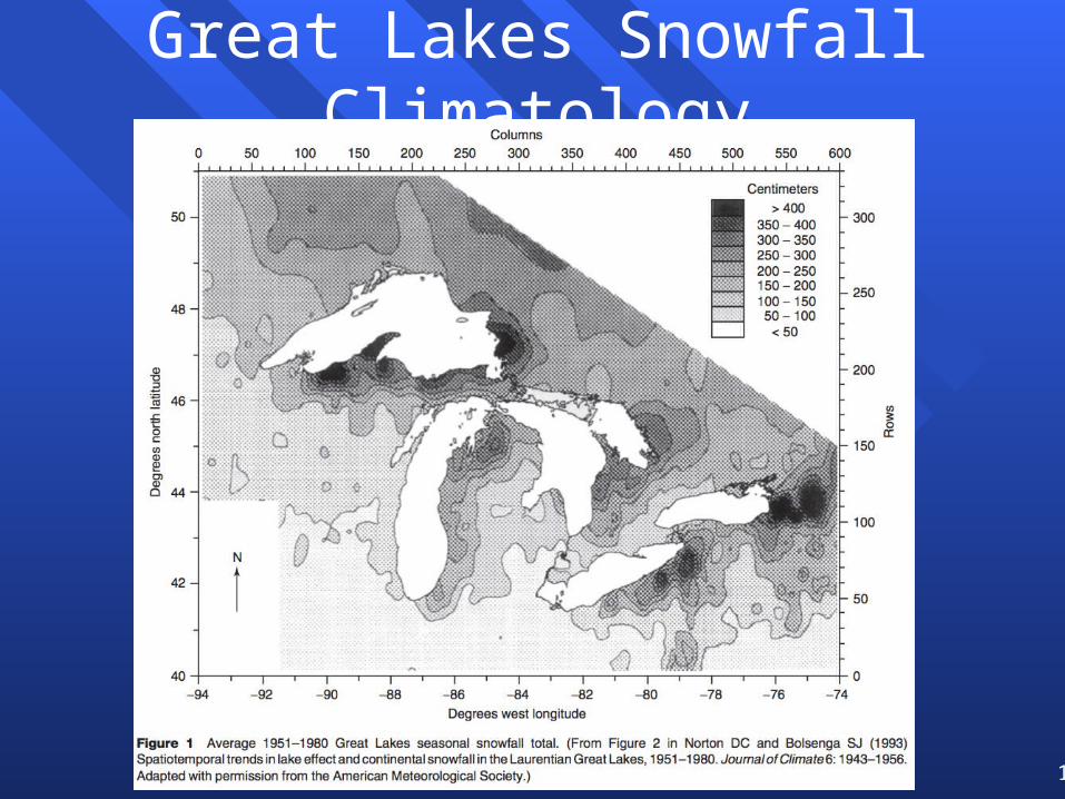
Great Lakes Snowfall Climatology

12
Zooming In – The Average Annual Snowfall (inches) Over the Eastern
Great Lakes

13
Record Event
37.9 inches at the Buffalo Airport in 24 h
15
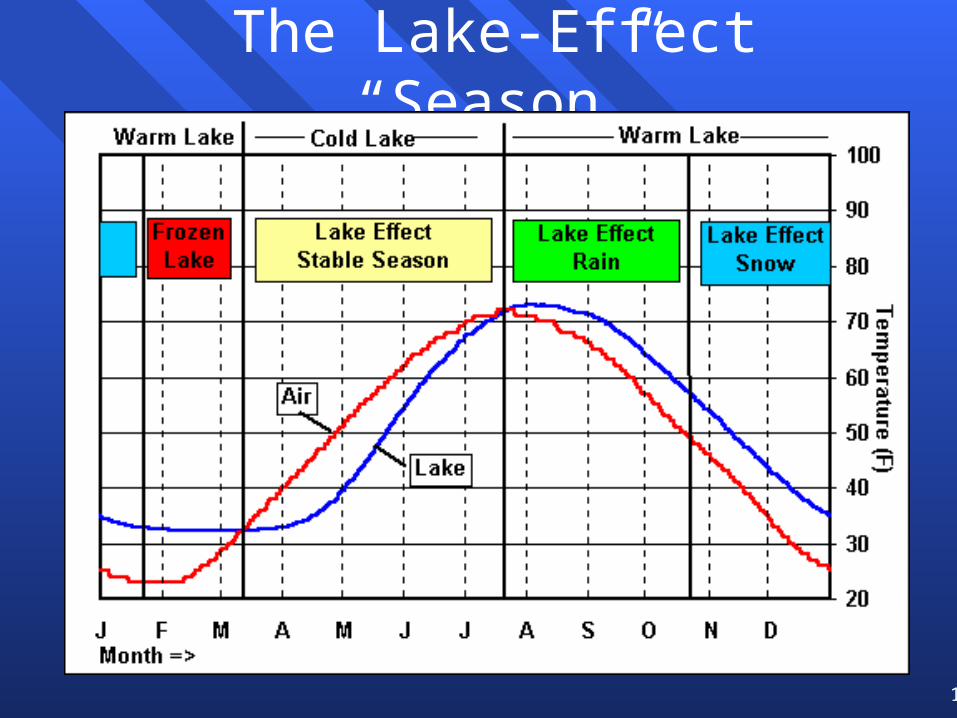
The Lake-Effect “Season”

16
Basic Concepts of Formation

17
Basic Concepts of Formation
The atmosphere upwind of thelake is characterized by a verystrong temperature inversion, witharctic air near the ground. Air isblowing from the land toward thewater.

19
Basic Concepts of Formation

20
Basic Concepts of FormationThe warm water provides thermalenergy and moisture to theoverlying cold air – rememberthat thermal energy transportis from warm to cold. The warmair rises to form clouds. Note thatit also raises the height of thecapping inversion.

22
Basic Concepts of Formation
Note how the inversion has risen in altitude and thelower-levels of the atmosphere have moistened.

24
Basic Concepts of Formation
The rising air condenses to formprecipitation, and snow fallsdownwind of the shore line. Thegreater the air-water temperaturecontrast, the heavier the snowfall
25
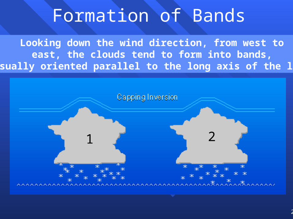
Formation of BandsLooking down the wind direction, from west to
east, the clouds tend to form into bands,usually oriented parallel to the long axis of the lake
1 2

27
Formation of Bands
Note the rising and sinking motion

28
Formation of Bands
Clouds are suppressed in between bands
Note the rising and sinking motion

29
Formation of Bands

30
Ingredient #1 for Formation
Sufficient temperature difference between the lake surface and overlying air– Represents a measure of instability, similar to
the lifted index in the context of thunderstorms– At least 13ºC difference between water and
850 mb surface– This is approximately the dry adiabatic lapse
rate between 1000 mb (surface) and 850 mb

31
The Temperature Difference on a Thermodynamic Diagram

32
Water Temperatures are Available
http://coastwatch.glerl.noaa.gov/cwdata/lct/glsea.png

33
The State of the Water and Land is Critical

34
Ingredient #2 for Formation
Sufficiently deep cold air mass at the surface–One of the most important aspects
when considering intensity– Inversion heights < 3000 ft preclude
heavy lake-effect snows– Inversion heights > 7500 ft strongly
support heavy lake-effect snows– In some cases, an inversion may not
be present or obvious

36
Basic Concepts of Formation

37
Ingredient #3 for Formation
Directional wind shear–Small amount of directional wind
change with height (< 30 degrees) below the inversion favors horizontal roll convection
–Highly sheared environments (> 60 degrees) disrupt and diminish the efficiency of rolls, leading only to flurries

38
Ingredient #4 for Formation
Adequate Fetch–Fetch is the distance traveled by air
over water–Long fetch promotes more heating of
the air and a higher inversion–A minimum fetch of 100 miles is
needed for significant lake-effect snow
–Flow over multiple lakes can help
39
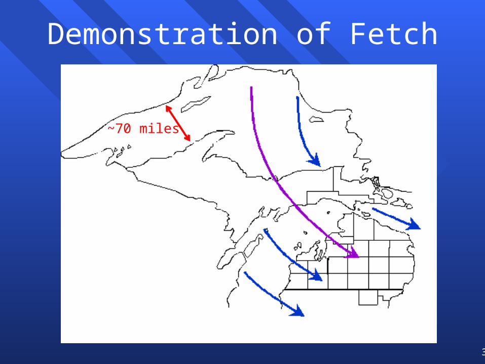
Demonstration of Fetch
~70 miles

40
Favorable Fetches for LE Snow

41
‘Preconditioning’ by upwind lakes
SeaWiFS: Dec 5, 2000
Lake Nipigon

42
‘Preconditioning’ by upwind lakes
MODIS: Dec 16, 2009
Lake Nipigon

43
Ingredient #5 for Formation
Sufficiently moist upstream air–RH > 70% below the inversion favors
heavy lake-effect snow–RH < 50% usually means little snow–Often upstream RH is the factor that
kills potentially heavy lake-effect events

44
Orographic Lift Can Make a HUGE Difference!
Lake Superior surface: 600 feetBrockway Mountain: 1330 feet

45
Effect of Orography

46
Shoreline Orientation Can Make a HUGE Difference!

47
Shoreline Orientation Can Make a HUGE Difference!
Change in surfacefriction as air passes from land to water causesconvergence in theregion shown by a “+”

48
Shoreline Orientation Can Make a HUGE Difference!
First bandforms in theconvergenceregion. Notedivergence“-” nearby

49
Shoreline Orientation Can Make a HUGE Difference!

50
This Theory in Action

51
This Theory in Action

52
Optimal snow growth T/RH
http://www.its.caltech.edu/~atomic/snowcrystals/primer/primer.htm
• Dendrites are the largest (lowest density) crystals and grow quickly• 850 mb temperatures of -10ºC or lower needed for heavy lake-effect snow

53
Cyclonic circulation
Cyclonic flow at ‘subgeostrophic’ wind speeds (e.g., through a low pressure trough) increases convergence and leads to heavier snowfall – check upper air charts (e.g., 850 mb)
Cyclonic curvature (height contours curve to left downstream)

54
If Atmosphere is SufficientlyUnstable, Thundersnowstorms
Can Form
55
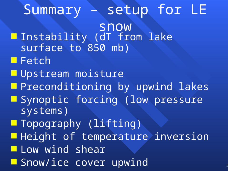
Summary – setup for LE snow Instability (dT from lake surface to 850 mb) Fetch Upstream moisture Preconditioning by upwind lakes Synoptic forcing (low pressure systems) Topography (lifting) Height of temperature inversion Low wind shear Snow/ice cover upwind Geometry of upwind lake shore