Embed Size (px)
Citation preview


1/23/18
1/30/18-1/30/19 1/30/18
Sean Wulfekuhle


FIRM REGISTRATION NO.:11047
EXPIRES: 11/30/2018
STATE OF ARIZONABOARD OF TECHNICAL
REGISTRATION
■ FIRM REGISTRATION ■
FIRM NAMEJ2 Engineering & Environmental Design
FIRM ADDRESS4649 E Cotton Gin Loop Suite B2Phoenix, AZ 85040
____________________________________
MELISSA CORNELIUS EXECUTIVE DIRECTOR FOR THE BOARD
SERVICES OFFEREDLandscape ArchitectEngineer Disciplines
Civil
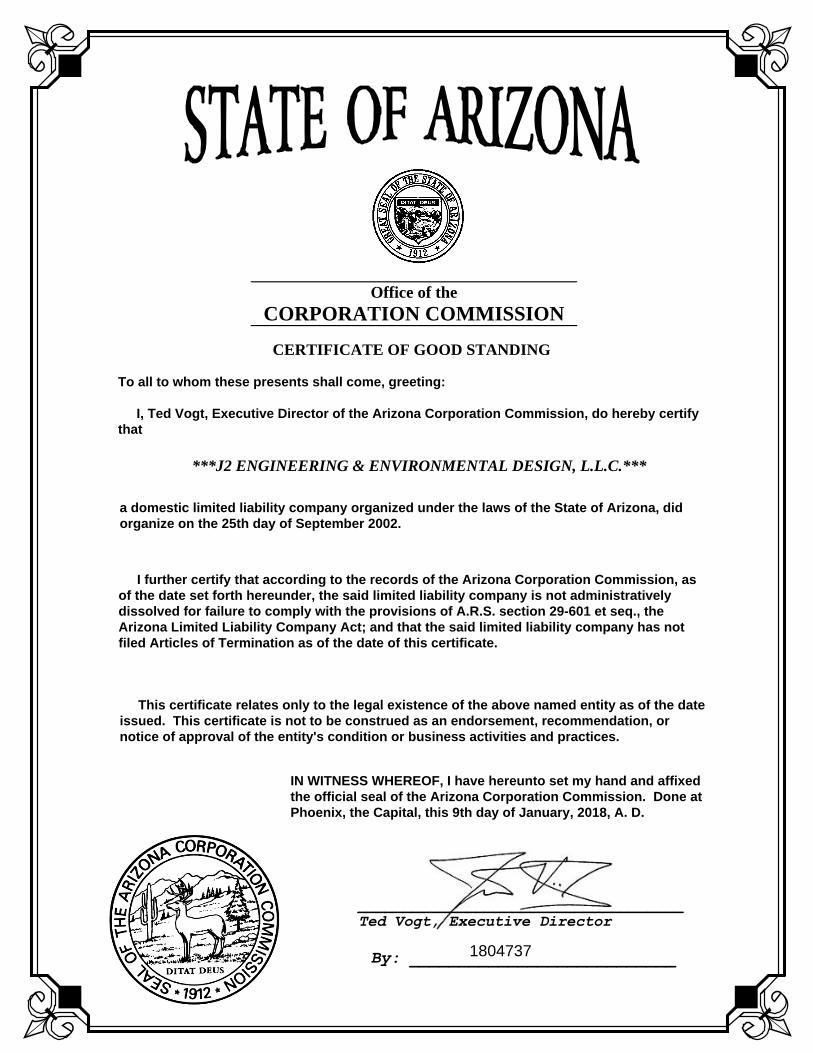
Office of theCORPORATION COMMISSION
____________________________________ Ted Vogt, Executive Director
By: ___________________________
CERTIFICATE OF GOOD STANDING
To all to whom these presents shall come, greeting:
I, Ted Vogt, Executive Director of the Arizona Corporation Commission, do hereby certifythat
***J2 ENGINEERING & ENVIRONMENTAL DESIGN, L.L.C.***
1804737
a domestic limited liability company organized under the laws of the State of Arizona, didorganize on the 25th day of September 2002.
I further certify that according to the records of the Arizona Corporation Commission, asof the date set forth hereunder, the said limited liability company is not administrativelydissolved for failure to comply with the provisions of A.R.S. section 29-601 et seq., theArizona Limited Liability Company Act; and that the said limited liability company has notfiled Articles of Termination as of the date of this certificate.
This certificate relates only to the legal existence of the above named entity as of the dateissued. This certificate is not to be construed as an endorsement, recommendation, ornotice of approval of the entity's condition or business activities and practices.
IN WITNESS WHEREOF, I have hereunto set my hand and affixedthe official seal of the Arizona Corporation Commission. Done atPhoenix, the Capital, this 9th day of January, 2018, A. D.


EXPERIENCE
AaronAllan, RLA, ASLA, CLARBSenior Landscape Architect
Aaron has 15 years of landscape architecture experience and has completed a wide variety of public works projects throughout Arizona. Aaron has outstanding experience leading mul disciplinary design teams on successful award-winning projects including design of public pedestrian spaces, environmental restora ons, and trails. Aaron has been involved in more than a dozen trails projects cons tu ng over 20 miles of pathways. Many of the projects involved mul ple stakeholder involvement. Aaron gives the J2 staff mul -faceted talent, due to his diverse exper se in parks and open-space master planning, hardscape and irriga on design, public presenta on, hor culture, and plan ng design.
Years Experience15 Years with J20 Years with other Firms15 Total Years of Experience
EducationB.S., Landscape Architecture, Arizona State University, 2003
Affi liationsAmerican Society of Landscape Architects
Council of Landscape Architectural Registra on Boards (CLARB) Cer fi ed
RegistrationLandscape Architect
Arizona #45439, 2006
Kansas #LA761, 2009
Nevada #852, 2011
New Mexico #527, 2014
Utah #7289718-5301, 2009
Certifi cationsCouncil of Landscape Architectural Registra on Boards (CLARB) Cer fi ed
Carefree Highway Trailhead (City of Phoenix) - Project ManagerAmeni es at this new 14.5 acre trailhead include a parking lot, restroom building, ramada, gates, paths, electrical, landscape salvage/installa on, irriga on and right-of-way. The master plan process provided several alterna ve layouts with preferred alterna ve as the basis of the Construc on Documents.
El Rio Watercourse Master Plan (City of Avondale) - Landscape Architect Provided complete watercourse master planning services. This project is a mul -community collabora on between the Flood Control District of Maricopa County, Maricopa County Parks and Recrea on, Maricopa County Planning and Development and the Ci es of Avondale, Buckeye and Goodyear. The Master Plan outlines a conceptual fl ood mi ga on strategy to protect future and exis ng development, provides recrea onal and economic development opportuni es and preserves and restores the river’s natural func on. The Master Plan covers an 18-mile reach of the Gila River from the confl uence with the Agua Fria River west to the SR-85 Bridge and includes areas within Avondale, Buckeye and Goodyear, as well as unincorporated Maricopa County.
N100/N12 Feasibility Study & Design (BIA) - Landscape ArchitectPhase I of this two phase project for the Bureau of Indian Aff airs (BIA) consists of a feasibility study providing an evalua on based on engineering analysis of an alterna ve
secondary access into the tribal government complex. Phase II consists of the design and construc on por on of the project based on the approved recommenda ons from the feasibility study. The design por on, at a minimum, will include the complete plans, specifi ca ons, and engineers es mate (PS&E) to re-construct exis ng Navajo Region Division of Transporta on (NRDOT) route N100 to an all weather paved route, including necessary approach roadways, round-a-bout, landscaping, and street ligh ng.
I-10 Sound Wall Aesthe cs (City of Avondale) - Project Manager The aesthe cs adorn bridge piers, abutment walls, slope pavement, and sound walls associated with the planned improvements for Interstate 10. Each of these themes was represented through the unique designs created by J2, enhancing all elements associated with each of the bridge renova ons. J2 developed conceptual designs, for each of the three bridges and presented them to the City’s Art Commission and the Avondale City Council.
Western Power Line Trail (Town of Gilbert) - Landscape Architect Created the landscape master plan and fi nal construc on documents for this two-mile, mul -use trail that extends from Cooper Road to Lindsay Road along the Western Canal. This project traverses through downtown Gilbert where the design of the trail turns into a linear park, crea ng a public gathering area punctuated by water features, hardscape plazas, and grassy open space.

Aaron Allan, RLA, ASLA
Tres Rios Recrea on Master Plan Project (City of Phoenix) - Landscape ArchitectThis restora on project was jointly funded by the USACE and the SROG. Designed and wrote the Master Plan report that provided the roadmap for the future development of the recrea onal components that will be integral to the success of the Tres Rios recrea on eff orts. The programmed improvements including trails, trailheads, and an environmental educa on center are all a part of the Tres Rios Environmental Restora on Project Phase II (project) at the Salt and Gila Rivers west of Phoenix.
SR202L (Santan) Mul -Use Trail (Town of Gilbert) - Landscape ArchitectThese concrete trail system segments are supplemented by private development trails that connect the breaks in con nuity. Eventually the trail system will run from Gilbert to Power. Aaron was part of the design team and development of concepts for u lizing several of the planned drainage basins as parks and open space, designing them to have extensive trails and trail head func on.
Water Tower Plaza (Town of Gilbert) - Project Manager This ¾ acre park site, in the heart of the Heritage District, sits under a 120 foot tall historic water tower. Provided public involvement, master planning landscape architecture, irriga on, and civil engineering design services for the park. Partnering with Arizona State Decision Theater, J2 created 3D models that allowed the public to do a virtual walk through of the plaza.
Veteran’s Park (City of Tolleson) - Landscape ArchitectProject consisted of master planning of 10-acre park. Park includes lighted fi elds, picnic areas, restroom building and a covered stage with turf amphitheater. Design u lized green building and sustainable design concepts as much as possible in order to achieve LEED Cer fi ca on for the park site.
Dobson Road Complete Streets Project: US60 to Broadway Road (City of Mesa) - Landscape ArchitectThe City of Mesa Dobson Road Complete Streets Project: US60 to Broadway Road study area consists of approximately 1.6 miles of Dobson Road from the US60 to approximately 500 feet north of Broadway Road. The intent of the study is to determine the feasibility and the degree of implementa on, retrofi ng, and construc on improvements to Dobson Road
u lizing complete street design features that will provide a safer and friendlier transporta on corridor for all users inclusive of vehicles, transit, bicyclists, and pedestrian users of all abili es and from children to the elderly. The project will implement and construct wider sidewalks, separated bike lanes with enhanced striping, landscaped bio-swales, raised center medians with landscape, signing and striping modifi ca ons to Dobson Road for lane narrowing, and traffi c signal and ligh ng modifi ca ons.
Dust Devil Park (City of Phoenix) - Project ManagerProvided on and off -site improvements for this award-winning 14 acre neighborhood park. Project scope included half street improvemets, grading, storm drain design, sewer design, parking, ligh ng, turf play areas, landscaping, restrooms, splash pad, playground, basketball courts, skate plaza, ramadas, and pathways. J2 provided all civil engineering, drainage design, hardscape, landscape, roadway improvements, ligh ng, u li es, off -site drainage analysis, and irriga on design.
Rio Salado Pathway Segment 4 (City of Mesa) - Project ManagerRio Salado Pathway Segment 4 is a shared-use pathway that parallels the Salt River in Mesa. Segment 4 is runs between the access tunnel connec on to River View Park under the SR202L Red Mountain Freeway and proceeds easterly to the SR202L/Dobson Road traffi c interchange. Improvements consist of an asphalt shared-use path, safety railing, pathway ligh ng, rest nodes, site furnishings, and landscaping and irriga on improvements. This project u lized federal funding so the project was developed to meet federal standards and guidelines.
Heritage Pathway (Town of Gilbert) - Project ManagerThis shared-use pathway follows along the eastern bank of SRP’s Consolidated Canal from Warner Road to Lindsay Road (just south of Guadalupe). Aaron was part of the team providing overall project management, civil engineering, drainage engineering, landscape architecture, irriga on design, and public involvement. Major entry points to the pathway were enhanced with landscaping, a semi-custom ramada, and decora ve pavement in the shape of leaves and tree rings. At 95% construc on documents, the project was placed on hold due to the construc on of a SRP well.
CONTACT
J2 Engineering and Environmental Design, LLC
4649 E. Co on Gin Loop, Suite B2 Phoenix, Arizona 85040
T 602.438.2221 ext 114
F 602.438.2225
h p://www.j2design.us

EXPERIENCE
Jamie Blakeman, PE, PTOETraffic Engineer
Jamie has 20 years of transporta on experience with par cular emphases in traffi c studies and design, transporta on planning, and ligh ng study and design. Her experience in the area of traffi c studies and analyses include safety studies, traffi c impact studies, parking studies, crash analysis, traffi c calming studies, mul -modal transporta on studies, speed studies, ligh ng studies and safe route to school studies. She has led a variety of design projects including urban and rural highways, arterial roadways, low volume roads, traffi c interchange (TI) and intersec on designs of ligh ng, traffi c signals, signing and pavement marking and maintenance of traffi c control. Jamie has also prepared transporta on planning studies including transporta on master plans, design concept reports (DCR), project assessments, and corridor feasibility studies.
Years Experience3 Years with J217 Years with other Firms20 Total Years of Experience
EducationB.S., Civil Engineering, University of Hawaii, 1996
Affi liationsAmerican Society of Civil Engineers
Arizona Council of Engineering Companies
Ins tute of Transporta on Engineers
Intelligent Transporta on Society, Past President
Illumina ng Engineering Society
RegistrationProfessional Civil EngineerArizona #40961, 2004
Certifi cationsProfessional Traffi c Opera ons Engineer #3151
West Mesa Connector Shared Use Pathway (City of Mesa) - Traffic EngineerCompleting a linkage from the City of Mesa’s existing trail system to the City’s of Tempe and Scottsdale with a non-motorized multi-modal trail system is one of the major goals of this project. Currently the City of Tempe trail system ends at Tempe Town Lake. The extension of that trail system east under SR101L and SR202L freeway system is fast approaching construction. The linkage to this multi-modal trail to trails further east and west is part of the goal of this West Mesa Connector route. The proposed alignment will follow, wherever practical and acceptable to the City, SRP, MAG and the public the existing SRP canal system in this area. The proposed route for this project extends and connects into the existing multi-modal pathway at North Center Street and extends this pathway west to Dobson Road.
Fairway Drive Traffi c Study (City of Avondale) - Project ManagerThe Fairway Drive Traffi c Study analyzed the traffi c impacts along the proposed Fairway Drive alignment, which begins just north of Garfi eld Street to Van Buren Street. Traffi c opera ons and safety was evaluated for the corridor and intersec ons for the near-term (2025) and long-term (2035). This project included data collec on of exis ng condi ons and traffi c volumes, crash analysis, projec ng traffi c volumes for the near and long-term, capacity analysis of the roadway segments and intersec ons, and
recommenda ons for lane confi gura on, traffi c control and roadway geometrics.
Western Avenue Pedestrian Improvements (City of Avondale) - Traffi c EngineerProvided conceptual and fi nal design services for three pocket parks in the Historic Old Town District along Avondale’s Western Avenue. The intent of the project was to enhance the streetscape between 4th Street and Dysart Road with an urban pocket park system that would add to the District’s sense of place and encourage more pedestrian and economic ac vity along Western Avenue. Scope included concept renderings, stakeholder outreach mee ngs, construc on document plans and specifi ca ons, and cost es mates. The project included 3D photo simula on renderings, pedestrian circula on improvements, hardscape and landscape enhancements, seatwalls, and public gathering space.
N100/N12 Feasibility Study and Design (BIA) - Traffi c Engineer Phase I of this two phase project for the Bureau of Indian Aff airs (BIA) consists of a feasibility study providing an evalua on based on engineering analysis of an alterna ve secondary access into the tribal government complex. Phase II consists of the design and construc on por on of the project based on the approved recommenda ons from the feasibility study. The design por on, at a minimum, will include the complete plans, specifi ca ons, and engineers es mate (PS&E) to re-construct exis ng Navajo Region Division
Jamie Blakeman, PE, PTOE
of Transporta on (NRDOT) route N100 to an all weather paved route, including necessary approach roadways, round-a-bout, landscaping, and street ligh ng.
Fiesta District Improvements (City of Mesa) - Traffic EngineerThis streetscape revitalization, place marking, and urban design project is the first step in developing the District into a mixed-use pedestrian friendly destination environment. The overall project spans 1.8 miles from the Tempe Canal east to Extension Road.lanes and bus bays in each direc on; a bus rapid transit lane on Chandler Boulevard; u lity reloca ons; new traffi c signals; and the addi on of two thru lanes, median modifi ca ons and street light improvements, and a mil and overlay on Dobson Road from Chandler Boulevard to Frye Road.
Pavement Management (City of Avondale) - Project ManagerProvided pavement marking and signing plans incorpora ng bike lanes and buff ers when possible on eight roadway segments as part of the Spring 2015 Pavement Management project. This included collec ng exis ng roadway width, signing and match point striping dimensions to match into at each end of the project. Along with the necessary modifi ca ons to the pavement marking and signing, the plans included all recommenda ons for other signing improvements to meet current standards.
On-Call Tasks (City of Avondale) - Project ManagerServed as the Project Manager for the FY 2012/2013, FY 2013/2014, FY 2014/2015, and FY 2015/2016 City of Avondale On-Call. A wide range of tasks were completed with this contract including signal designs, signing and pavement marking plans, neighborhood traffi c studies, school related traffi c studies, traffi c studies, fi eld reviews, and plan reviews. • Rancho Santa Fe Blvd, Dysart to McDowell• City Center, Phase III• McDowell Road and Friendship Park• Thomas Road and 111th Avenue• McDowell Road – Agua Fria River to
Avondale Boulevard• Quen n Elementary School• Indian School Rd, Dysart Rd to El Mirage Rd• Fairway Drive Traffi c Study• Pavement Management
Fry Boulevard, West End Corridor Study (City of Sierra Vista) - Traffi c EngineerAs part of the Fry Boulevard, West End Corridor Study, Jamie completed a mul -modal traffi c study from Buff alo Soldier Trail to 7th Street. This project includes iden fying mul -modal transporta on and streetscape design op ons, green infrastructure improvements, and programma c strategies to improve the corridor with a par cular focus on how transporta on and streetscape strategies impact place-making and economic development. The J2 team will provide conceptual design services (Landscape Architecture, Urban Design Analysis, Engineering, Traffi c Engineering, Signage / Wayfi nding / Monumenta on, Cost Es ma ng and Public/Stakeholder Outreach) to prepare a Concept Design Plan Report which will summarize the Conceptual Design eff ort.
Safe Routes to School (Ci es of Avondale and Goodyear) - Traffi c EngineerJamie and her team were responsible for providing engineering services to help improve traffi c safety, reduce confl icts, and increase effi ciency at surrounding eight elementary schools. Conducted on-site and off -site data collec on, observa ons and analysis; coordinated mee ngs with school staff , school district and City offi cials to discuss project scope, ingress and egress procedures and concerns, observa on details, and recommended improvements. Compiled a comprehensive report documen ng background informa on, observa ons, analysis, fi gures, recommenda ons for improvements, as well as a Safe Routes to School Map for all homes within the walking boundaries were submi ed to the school, school district and City offi cials.
Ellsworth Road (City of Mesa) - Traffi c EngineerImprovement of a two lane rural roadway to a fi ve lane urban arterial roadway with catch basins and a 60” storm drain main. J2’s responsibili es included project management, roadway design and coordina on with the City of Mesa, MCDOT, ADOT and U lity companies.
CONTACT
J2 Engineering and Environmental Design, LLC
4649 E. Co on Gin Loop, Suite B2 Phoenix, Arizona 85040
T 602.438.2221 ext. 121
F 602.438.2225
h p://www.j2design.us

EXPERIENCE
Jeffrey Engelmann, RLA, ASLAPrincipal Landscape Architect & Urban Designer
Jeff has more than 34 years of experience and has been involved in a wide variety of landscape architecture projects throughout Arizona, Nevada and the Midwest. The numerous public park projects he has been involved with encompass a wide variety of experiences ranging from pocket parks of less than ½ acre to large regional sports complexes that cover mul ple acres and the design of numerous trail systems (equestrian and pedestrian) that traverse en re river corridors and municipal boundaries. Jeff ’s depth and breadth of experience includes parks and open space planning and design, athle c facili es, city parks (community and neighborhood) and recrea on master plans, streetscapes, roadside buff ering concepts, pedestrian/bicycle/equestrian trail design, revegeta on, public presenta ons and ci zen work group sessions. In addi on, he has done downtown revitaliza on projects and urban designs where extensive hardscape and urban plazas have been created.
Years Experience15 Years with J219 Years with other Firms34 Total Years of Experience
EducationB.L.A, Landscape Architecture, Iowa State University, 1983
AutoCAD Management & AutoCAD Professional, Tempe CADD Ins tute, 1988
Affi liationsAmerican Society of Landscape Architects
RegistrationLandscape Architect
Arizona #23430, 1989
Kansas # 581, 1995
Missouri #000166, 1994
Fiesta Sports Park (City of Mesa) - Project Manager / Project PrincipalThis park design and master plan beau fully accommodates a lighted championship baseball diamond complex and parking and will also include a restroom/concessions building and a shaded play areas. The park wraps around the ac ve Mesa Public School facili es which required close coordina on for safety and security issues.
Copper Sky Park (City of Maricopa) - Project ManagerThe D-B team was selected to master plan, design, and construct this 110-acre complex which includes four lighted mul -use fi elds, four unlighted mul -use fi elds, a lighted four-plex so ball/li le league baseball diamond complex, basketball courts, sand volleyball courts, tennis courts, two restroom concession buildings, maintenance/storage facili es, u lity design and coordina on, roads, and parking lots.
Dust Devil Park (City of Phoenix) - Project PrincipalThis 14 acre neighborhood park project’s off -site improvements included roadways, signing and striping, street ligh ng, water and sewer line extension to the site, power delivery to the site, off -site drainage analysis, and u lity coordina on. On-site improvements includes two parking lots, site ligh ng, open turf play areas, landscaping, restroom building, splash pad, playground with shade structure, basketball courts, LED ligh ng, skate plaza, ramadas, a
picnic plaza, and pathways. The site ligh ng is energy effi cient LED ligh ng.
Desert Breeze Park Improvements (City of Chandler) - Project ManagerJ2 provided professional design services which included a master plan, fi nal construc on documenta on, specifi ca ons and cost es mates for this four-acre phase of the park’s development. The park design was focused on providing mul -use sports fi elds and a new path system for a connec on to the exi ng park.
Desert Mountain Park (Town of Queen Creek) - Project ManagerAc ve sports complex improvements included three lighted soccer/football fi elds, a championship four-plex so ball diamond complex, restroom concession buildings, parking, mul -use trails, basketball courts, ramadas, play areas, small amphitheater, and desert botanical garden area. Scope included water and sewer line extensions/ e-ins, paving, storm water reten on/basins, grading and drainage, and striping and signage plans. J2 provided ½ street improvement plans for Oco llo and Hawes Roads.
Discovery and Cosmo Basin Parks (Town of Gilbert) - Project ManagerThe 65-acre Discovery Park included the design of two water features, numerous picnic ramadas, lighted concrete trails, lighted soccer fi elds, play area, basketball courts, restroom/concession buildings, parking, general civil, and areas designed for large gatherings. The sixteen acre Cosmo Park design included

Jeffrey Engelmann, RLA, ASLA
a central entry, water feature, dog park, restroom building, parking lot, electrical design, grading, drainage, and water and sewer extensions.
Veteran’s Park (City of Tolleson) - Project PrincipalProject consisted of master planning of 10-acre park. Park includes lighted fi elds, picnic areas, restroom building and a covered stage with turf amphitheater. Design u lized green building and sustainable design concepts as much as possible in order to achieve LEED Cer fi ca on for the park site.
Fiesta District Improvements (City of Mesa) - Project PrincipalThis streetscape revitaliza on, place making, and urban design project is the fi rst step in developing the District into a mixed-use pedestrian friendly des na on environment. J2 is part of a mul -disciplinary team providing design for the open space, streetscape, and urban design elements along Southern Avenue in Mesa’s Fiesta District. The overall project area spans 1.8 miles from the Tempe Canal east to Extension Road.
Tumbleweed Park Phase 5 and Playtopia (City of Chandler) - Project ManagerJ2 was the prime consultant responsible for the civil, drainage, and landscape architecture design. Jeff served as the Project Principal. Phase 5 of the park included mul -use sports fi elds, ramadas, and the popular three-acre des na on playground known as ‘Playtopia’. The civil design por on of the project included earthwork analyses to balance the site, grading and drainage plans, water and sewer plans, parking lot design, etc. Phase V of the park was designed to blend into the exis ng park improvements. The project required prepara on of plans, quan ty and cost es mates, and specifi ca ons.
Fiesta Paseos (City of Mesa) - Project PrincipalThe Paseo Improvements is a fi ve-room open space “node” project along Southern Avenue between Dobson and Alma School Road. The improvements will consist of hardscape, landscape and open space improvements, bicycle and pedestrian ameni es, custom ligh ng systems, a water feature, and custom shade structure elements.
Downtown Mesa Medians Streetscape (City of Mesa) - Project Manager J2 was responsible for developing the median landscape and pavement design that was to be an integral part of the downtown’s revitaliza on program. The project included the design of decora ve pa erns for concrete pavers for crosswalks and in the medians, along with new ligh ng and landscape plans and new irriga on system.
Dobson Road Pedestrian & Bicycle Improvements (City of Mesa) - Project PrincipalThe Dobson Road Pedestrian & Bicycle improvement project provides connec on for both pedestrian and bicycle users along Dobson Road to the light rail facility at Main and Sycamore, commercial developments along Main, Broadway and Dobson Roads and the residen al neighborhoods to the south of Broadway and north of Main. In addi on to these linkages the pathway provides a connec on between the City of Mesa Fiesta and West Main Districts.
Gilbert Road and University Drive Intersec on (City of Mesa) - Landscape Architect The City of Mesa developed Gilbert Road and University Drive to a seven lane roadway with a raised median in Gilbert Road. J2 provided both landscaping and irriga on design services for the raised medians in Gilbert Road and landscape and irriga on behind the sidewalk along both project limits where space permi ed landscape and irriga on to be installed and improved.
Light Rail Extension (City of Mesa) - Landscape Architect J2 is a sub-consultant to Jacobs for all landscape architecture and irriga on design for this extension of light rail into downtown Mesa.
West Chandler Park Master Plan and Design (City of Chandler) - Project Manager40-acre community park includes so ball and baseball complexes, restroom/concessions building, maintenance building and storage area, and soccer/football fi eld.
Horseshoe Park and Equestrian Center (Town of Queen Creek) - Project Manager / PrincipalMaster plan, civil engineering, drainage/irriga on design, and construc on documents for this 40 acre, $15 M equestrian event center and community arena.
CONTACT
J2 Engineering and Environmental Design, LLC
4649 E. Co on Gin Loop, Suite B2 Phoenix, Arizona 85040
T 602.438.2221 ext. 103
F 602.438.2225
h p://www.j2design.us

EXPERIENCE
Jeff Holzmeister, PEPrincipal, Civil & Water Resource Engineer
Jeff has 34 years of water resources and general civil engineering experience. He has been involved in a wide range of water resource and general civil engineering projects throughout Arizona. Inves ga on of these projects has required analyses of surface water hydrology, water distribu on systems, open channel hydraulics, and sediment transport analyses. In addi on to technical engineering analyses, the majority of these projects have also required the development of construc on cost es mates, opera on and maintenance plans, and benefi t/cost analyses to determine the economic feasibility of a specifi c fl ood control or drainage plan. Jeff is experienced in the applica on of the HEC-1, HEC-2/HEC-RAS, HEC-6, StormCadd, and FLO-2D computer programs.
Years Experience15 Years with J219 Years with other Firms34 Total Years of Experience
EducationM.S., Water Resources Engineering, University of Kansas, Lawrence, Kansas, 1988
B.S., Civil Engineering, University of Kansas, Lawrence, Kansas, 1983
Affi liationsAmerican Society of Civil Engineers
Arizona Council of Engineering Companies
Arizona Floodplain Managers Associa on
RegistrationProfessional Civil Engineer
Arizona #23170, 1989
Kansas #PE21547, 2011
Missouri #2011007345
Nevada #11572, 1995
New Mexico #20445
Utah #8906556-2202, 2014
Tempe Area Drainage Master Study / Plan (FCDMC) - Project ManagerThis project was to evaluate Tempe’s overall drainage system (total 47 mile²) using 2-dimensional modeling so ware of FLO-2D. This ADMS is intended to iden fy drainage and fl ooding problems in Tempe and to develop alterna ve measures to mi gate iden fi ed concerns. Within the last fi ve years, there have been mul ple storm events causing street drainage problems and fl ooding. Tempe is expec ng major redevelopment of por ons of the City and as a response to this projected growth the City is considering implementa on of various green infrastructure and low impact design techniques as part of the General Plan. Three dependent FLO-2D models were developed with more than one million grids for each of the three models to cover the en re project area (47 mile²). Complex storm drain systems with 147 of miles pipes, 2,767 inlets, 110 ou alls, and 6 pumps were modeled with the integra on of FLO-2D and EPA SWMM models.
West Mesa Connector Shared Use Pathway (City of Mesa) - Project PrincipalCompleting a linkage from the City of Mesa’s existing trail system to the City’s of Tempe and Scottsdale with a non-motorized multi-modal trail system is one of the major goals of this project. Currently the City of Tempe trail system ends at Tempe Town Lake. The extension of that trail system east under SR101L and SR202L freeway system is fast approaching construction. The linkage to this multi-modal trail to trails further east and
west is part of the goal of this West Mesa Connector route. The proposed alignment will follow, wherever practical and acceptable to the City, SRP, MAG and the public the existing SRP canal system in this area. The proposed route for this project extends and connects into the existing multi-modal pathway at North Center Street and extends this pathway west to Dobson Road.
Carefree Highway Trailhead (City of Phoenix) - QAQCAmeni es at this new 14.5 acre trailhead include a parking lot, restroom building, ramada, gates, paths, electrical, landscape salvage/installa on, irriga on and right-of-way. The master plan process provided several alterna ve layouts with preferred alterna ve as the basis of the Construc on Documents.
52nd Street and Turquoise Avenue Drainage Study City of Phoenix) - Project ManagerJeff performed engineering analyses required to develop mi ga on measures for storm water fl ooding in the vicinity of 52nd Street and Turquoise Avenue. FLO-2D hydrologic modeling was performed for the 2-, 10-, and 100-year storm events. The contribu ng watershed area is approximately four square miles. The grid systems (12’x12’ cells with total 803,229 grids) for models were developed. Data collec on was conducted. Major fl ooding issues were iden fi ed and three fl ood mi ga on alterna ves for the three design storms were modeled and evaluated. Preliminary drainage plans were

Jeff Holzmeister, PE
developed with associated quan ty and probable cost es mates.
N100/N12 Feasibility Study & Design (BIA) - QA/QC Phase I of this two phase project for the Bureau of Indian Aff airs (BIA) consists of a feasibility study providing an evalua on based on engineering analysis of an alterna ve secondary access into the tribal government complex. Phase II consists of the design and construc on por on of the project based on the approved recommenda ons from the feasibility study. The design por on, at a minimum, will include the complete plans, specifi ca ons, and engineers es mate (PS&E) to re-construct exis ng Navajo Region Division of Transporta on (NRDOT) route N100 to an all weather paved route, including necessary approach roadways, round-a-bout, landscaping, and street ligh ng.
Fiesta Sports Park (City of Mesa) - Project PrincipalThis project included the master planning phase and development of sealed construc on documents with extensive public involvement and outreach, coordina on with the City of Mesa commi ees, as well as presenta on and approval of the master plan and the design and layout of park improvements by City and local stakeholders. The design beau fully accommodates a lighted championship baseball diamond complex and parking and will also include a restroom/concessions building and a shaded play area. The park wraps around the ac ve Mesa Public School facili es which required close coordina on for safety and security issues.
Granite Creek Floodplain Delinea on Study (FCDMC) - Project ManagerJeff was responsible for the FDS and submi al of a LOMR request to FEMA for eight tributaries of Granite Creek totaling 25.8 miles within the Presco city limits and adjacent unincorporated areas of Yavapai County. New topographic mapping and hydrology were developed for this project. FEMA has completed and approved this study and is now processing it as a physical map revision (PMR).
City of Mesa Fiesta District ImprovementsProject Engineer This street scape revitaliza on, place making, and urban design project is the fi rst step in developing the District into a mixed-use pedestrian friendly des na on
environment. J2 is part of a mul -disciplinary team providing design for the open space, streetscape, and urban design elements along Southern Avenue in Mesa’s Fiesta District. The overall project area spans 1.8 miles from the Tempe Canal east to Extension Road.
12th Street Roadway and Storm Drain Improvements (City of Phoenix) - Project ManagerProject responsibili es consisted of design of Storm Drain main along with catch basins, project quan es and cost es mate, and assisted in the roadway design of 12th Street between Broadway Road to Elwood Street.
107th Avenue DCR (City of Phoenix) - Project PrincipalThe project entailed presen ng three diff erent alterna ves for half street roadway widening improvements between Indian School Road and Camelback Road. These op ons looked at half street widening which included meandering sidewalk, landscaping, ling the Roosevelt Irriga on Canal, and ling the Salt River Project Canal. The scope of the project included public involvement and presenta ons, u lity research and coordina on, and storm drain preliminary design.
Downtown Redevelopment (City of Tolleson) - Project EngineerThe Downtown Tolleson Redevelopment project design balances vehicular, pedestrian, bicycle, and mass transit traffi c in order to develop a veritable mul -modal environment that will promote private investment in the Downtown area. The overall goal was to create a “live, work, shop, and play” environment that becomes a sustainable economic engine for the City of Tolleson and its residents.
Dobson Road Pedestrian & Bicycle Improvements (City of Mesa) - QA/QC The Dobson Road Pedestrian & Bicycle improvement project provides connec on for both pedestrian and bicycle users along Dobson Road to the light rail facility at Main and Sycamore, commercial developments along Main, Broadway and Dobson Roads and the residen al neighborhoods to the south of Broadway and north of Main. In addi on to these linkages the pathway provides a connec on between the City of Mesa Fiesta and West Main Districts.
CONTACT
J2 Engineering and Environmental Design, LLC
4649 E. Co on Gin Loop, Suite B2 Phoenix, Arizona 85040
T 602.438.2221 ext. 105
F 602.438.2225
h p://www.j2design.us

EXPERIENCE
Daniel Selk, PE, CFMH&H Engineer / GIS Specialist
Daniel has six years of engineering experience, mainly comprised of drainage design and hydrologic and hydraulic studies. Daniel’s experience includes modeling and quality control of riverine hydrology and hydraulics using 1 and two dimensional computa onal so ware, as well as early experience in land surveying and dra ing. Projects range from approximate, limited-detailed, and detailed fl ood insurance studies to seismic dam upgrade studies. More recently, projects worked on include two dimensional hydrologic and hydraulic model studies u lizing storm drain networks. Clients include Maricopa County Flood Control District, California Division of Water Resources, New Jersey Department of Environmental Protec on, and FEMA regions I, IV, VIII, IX.
Years Experience4 Years with J22 Years with other Firms6 Total Years of Experience
EducationB.S., Civil Engineering, University of Kansas, 2011
Affi liationsAmerican Society of Civil Engineers
Associa on of State Floodplain Managers, Cer fi ed Floodplain Manager
RegistrationProfessional EngineerArizona #61514, 2016
Certifi cationsCer fi ed Floodplain Manager, CFM No. US-12-06405
Fiesta Sports Park (City of Mesa)Civil / Drainage EngineerThis park design and master plan beau fully accommodates a lighted championship baseball diamond complex and parking and will also include a restroom/concessions building and a shaded play areas. The park wraps around the ac ve Mesa Public School facili es which required close coordina on for safety and security issues.
Copper Sky Park (City of Maricopa)Civil / Drainage EngineerThe D-B team was selected to master plan, design, and construct this 110-acre complex which includes four lighted mul -use fi elds, four unlighted mul -use fi elds, a lighted four-plex so ball/li le league baseball diamond complex, basketball courts, sand volleyball courts, tennis courts, two restroom concession buildings, maintenance/storage facili es, u lity design and coordina on, roads, and parking lots.
Tempe Area Drainage Master Study / Plan (FCDMC)Drainage DesignerJ2 was hired to evaluate Tempe’s overall drainage system. The Tempe ADMS is intended to iden fy drainage and fl ooding problems in Tempe and to develop alterna ve measures to mi gate iden fi ed concerns. Within the last fi ve years, there have been mul ple storm events causing street drainage problems and fl ooding. Tempe is expec ng major redevelopment of por ons of the City and as a response
to this projected growth the City is considering implementa on of various green infrastructure and low impact design techniques as part of the General Plan.
US60 Off Site Drainage System Analysis (ADOT)Drainage DesignerJ2 provided data collec on, rainfall analysis, refi nement of exis ng hydrologic models, and developed new hydrologic models of the exis ng US60 drainage systems to quan fy the September 8, 2014 storm event in Mesa, Arizona. Using this informa on , the project team is analyzing changes to op mize the system.
Region IX FY10 RiskMAP (FEMA)Drainage DesignerThis project consisted of rainfall-runoff analysis using HEC-HMS for 10%, 4%, 2%, 1%, and 0.2% annual chance rainfalls developed with SCS 24-hour type 1 rainfall distribu ons for basins within the county. 1D/2D modeling of the county was performed using XPSWMM 2D so ware. The project area was split into 4 separate models and included cascading ou lows from upstream models to downstream model infl ows. The 1D/2D models include dispersed hydrology in addi on to HEC-HMS generated infl ows.

Daniel Selk, PE, CFM
Region IX FY09 RiskMAP (FEMA)Drainage DesignerDeveloped 1D/2D hydraulic models for 232 square miles of detailed study streams in Kings County. Models developed using XPSWMM 2D so ware and include numerous structures, weirs, and 1D hydraulic components. 2D modeling area was split into 3 modeling areas and included cascading. The model developed in this study is to extend into future studies of neighboring Fresno county.
Region I FY11 RiskMAP (FEMA)Drainage DesignerPerformed quality control/quality assurance for hydrologic and hydraulic models for streams in Piscataqua. Project included updates of hydrologic and hydraulic models for studies using AECOM in-house so ware WISE Swi MAP program.
Region IX FY10 RiskMAP (FEMA)H&H EngineerPerformed quality control/quality assurance subject to FEMA Guides and Specifi ca ons Appendix C. This por on of study consisted of approximately 10 miles of detailed study streams in Ventura County including the Santa Clara River and tributaries.
Region IV Updated Flood Hazard Data and Mapping for FY10 Map Maintenance Coun es (FEMA)H&H EngineerCompleted 1D hydraulic modeling in HEC-RAS for a detailed study of eight miles of stream in Guilford County. Also performed quality control/quality assurance review of 2D hydraulic models made in XPSWMM so ware for Pender County.
Region VIII FY10 RiskMAP (FEMA)H&H EngineerPerformed quality assurance and quality control for hydrologic studies. Methods used include rainfall-runoff analysis, gage analysis including gaged transfer analysis, and regression analysis. Studies included Whitefi sh River and West Spring Creek in Flathead County as well as Flint Creek and Lower Willow Creek in Granite County.
Flood Insurance Rate Map Database (Iowa Department of Natural Resources)H&H EngineerProject included development of hydrologic data in accordance with Iowa Flood Center methodology, developed base-level hydraulic data, performed fl oodplain mapping with delinea on of 1% and 0.2% annual chance events.
Region VIII FY10 RiskMAP (FEMA)H&H EngineerPerformed quality control/quality assurance subject to FEMA Guides and Specifi ca ons Appendix C. This por on of study consisted of approximately 15 miles of detailed study streams within the Roaring Fork Watershed in Pitkin County.
Region IV Digital Flood Insurance Rate Map (FEMA)H&H EngineerPerformed the determina on of base fl ood eleva ons using zonal sta s cs in ArcGIS derived from MIKE11 2D modeling so ware.
Central Valley Flood Evalua on and Delinea on Program (California Division of Water Resources)H&H EngineerProject consisted of the hydraulic analyses of the Upper Sacramento River Basin with the applica on and integra on of unsteady fl ow HEC-RAS models into FLO-2D.
Lake Chabot Dam Seismic Upgrade (East Bay Municipal U lity District)H&H EngineerThis project refi ned a HEC-RAS steady state model under an accelerated schedule to include surveyed structures. Ineff ec ve fl ow areas, Manning’s n values, and cross sec on placements were modifi ed.
CONTACT
J2 Engineering and Environmental Design, LLC
4649 E. Co on Gin Loop, Suite B2 Phoenix, Arizona 85040
T 602.438.2221 ext 109
F 602.438.2225
h p://www.j2design.us

EXPERIENCE
JasonTouchin, PESenior Civil Engineer
Jason has over 23 years of experience, having been with J2 since 2004. During this period his role has evolved from project engineer to department head. Jason has been responsible for roadway design, the coordina on of personnel and assembly of plans, specifi ca ons and cost es mates on numerous projects ranging from rural pavement preserva on jobs, to urban arterial roadway design, to the $66 million light rail transit project in Phoenix. Jason draws upon his experience coupled with his construc on management background to provide innova ve solu ons that meet client needs. His client experience includes Arizona Department of Transporta on, Maricopa County Department of Transporta on, City of Phoenix, Town of Gilbert, City of Chandler and various other coun es and municipali es. Jason’s computer profi ciency includes Microsta on and Inroads.
Years Experience13 Years with J210 Years with other Firms23 Total Years of Experience
EducationB.S., Construc on Management, Arizona State University, 1994
Affi liationsAmerican Society of Civil Engineers
Arizona Council of Engineering Companies
RegistrationProfessional Engineer
Arizona #38806, 2003
52nd Street and Turquoise Avenue Drainage Study (City of Phoenix) - Project Civil EngineerPerformed engineering analyses required to develop mi ga on measures for storm water fl ooding in the vicinity of 52nd Street and Turquoise Avenue. FLO-2D hydrologic modeling was performed for the 2-, 10-, and 100-year storm events. The contribu ng watershed area is approximately four (4) square miles. The grid systems (12’x12’ cells with total 803,229 grids) for models were developed. Data collec on was conducted. Major fl ooding issues were iden fi ed and three (3) fl ood mi ga on alterna ves for the three (3) design storms were modeled and evaluated. Preliminary drainage plans were developed with associated quan ty and probable cost es mates.
Western Avenue Pedestrian Improvements (City of Avondale) - Project Civil EngineerProvided conceptual and fi nal design services for three pocket parks in the Historic Old Town District along Avondale’s Western Avenue. The intent of the project was to enhance the streetscape between 4th Street and Dysart Road with an urban pocket park system that would add to the District’s sense of place and encourage more pedestrian and economic ac vity along Western Avenue. The J2 scope included concept renderings, stakeholder outreach mee ngs, construc on document plans and specifi ca ons, and cost es mates. The project included 3D photo simula on
renderings, pedestrian circula on improvements, hardscape and landscape enhancements, seatwalls, and public gathering space.
N100/N12 Feasibility Study and Design (BIA) - Project ManagerPhase I of this two phase project for the Bureau of Indian Aff airs (BIA) consists of a feasibility study providing an evalua on based on engineering analysis of an alterna ve secondary access into the tribal government complex. Phase II consists of the design and construc on por on of the project based on the approved recommenda ons from the feasibility study. The design por on, at a minimum, will include the complete plans, specifi ca ons, and engineers es mate (PS&E) to re-construct exis ng Navajo Region Division of Transporta on (NRDOT) route N100 to an all weather paved route, including necessary approach roadways, round-a-bout, landscaping, and street ligh ng.
Fiesta Sports Park (City of Mesa) - Project Civil EngineerThis project included the master planning phase and development of sealed construc on documents with extensive public involvement and outreach, coordina on with the City of Mesa commi ees, as well as presenta on and approval of the master plan and the design and layout of park improvements by City and local stakeholders. The design beau fully accommodates a lighted championship

Jason Touchin, PE
baseball diamond complex and parking and will also include a restroom/concessions building and a shaded play area. The park wraps around the ac ve Mesa Public School facili es which required close coordina on for safety and security issues.
Trail Heads Master Plan (City of Phoenix) - Project Civil EngineerMaster planned three separate trail head sites within the mountain preserves of South Mountain and the Sonoran Preserve. Each trail head design went through a series of site analysis to determine its most suitable loca on. J2 also provided mul ple alterna ve conceptual designs with opinions of probable construc on costs. These separate concepts were eventually transformed into a preferred alternate concept. From these master plan documents the City was able to priori ze which trailhead to proceed with construc on documenta on fi rst.
Western Power Line Trail (Town of Gilbert) - Project EngineerCreated the landscape master plan and fi nal construc on documents for this two-mile, mul -use trail that extends from Cooper Road to Lindsay Road along the Western Canal. This project traverses through downtown Gilbert where the design of the trail turns into a linear park, crea ng a public gathering area punctuated by water features, hardscape plazas, and grassy open space.
Downtown Redevelopment (City of Tolleson) - Civil Design LeadThe Downtown Tolleson Redevelopment project design balances vehicular, pedestrian, bicycle, and mass transit traffi c in order to develop a veritable mul -modal environment that will promote private investment in the Downtown area. The overall goal was to create a “live, work, shop, and play” environment that becomes a sustainable economic engine for the City of Tolleson and its residents.
Durango Regional Conveyance Channel (FCDMC) - Project Civil EngineerJ2 was retained by the Flood Control District of Maricopa County for the Durango Regional Conveyance Channel Project. Jason’s team provided hydrologic analysis, hydraulic analysis, bank protec on design, and culvert design of the DRCC as well as prepara on of plans, es mates, and specifi ca ons for the project.
SSR202L (Santan) Mul -Use Trail (Town of Gilbert) - Project Civil EngineerThese concrete trail system segments are, or will be supplemented by private development trails that connect the breaks in con nuity. Eventually the trail system will run from Gilbert to Power. Jason’s design team developed concepts for u lizing several of the planned drainage basins as parks and open space, designing them to have extensive trails and trail head func on.
Gateway Shared Use Trail (City of Mesa) - Project Civil EngineerThe Mesa Gateway shared use Pathway Project creates a new six mile, ten-foot wide shared use pathway. The majority of this project corridor will run parallel to the exis ng SR202L freeway between Baseline Road to the north and Power Road to the south and will be located completely within the exis ng ADOT right-of-way. One segment will branch off of SR202L and follow SR24 Williams Gateway Freeway alignment connec ng this to Ray Road and the Eastmark Development.
Granite Creek Floodplain Delinea on Study (FCDMC) - Project Civil EngineerJ2 was responsible for the FDS and submi al of a LOMR request to FEMA for eight tributaries of Granite Creek totaling 25.8 miles within the Presco city limits and adjacent unincorporated areas of Yavapai County. New topographic mapping and hydrology were developed for this project. FEMA has completed and approved this study and is now processing it as a physical map revision (PMR).
Copper Sky Park (City of Maricopa) - Project Civil EngineerThe D-B team was selected to master plan, design, and construct this 110-acre complex which includes four lighted mul -use fi elds, four unlighted mul -use fi elds, a lighted four-plex so ball/li le league baseball diamond complex, basketball courts, sand volleyball courts, tennis courts, two restroom concession buildings, maintenance/storage facili es, u lity design and coordina on, roads, and parking lots.
CONTACT
J2 Engineering and Environmental Design, LLC
4649 E. Co on Gin Loop, Suite B2 Phoenix, Arizona 85040
T 602.438.2221 ext. 128
F 602.438.2225
h p://www.j2design.us

EXPERIENCE
JeffVelasquez, RLASenior Project Manager
Jeff has 22 years of private prac ce experience in the fi eld of landscape architecture. His wide variety of project experience has included planning, design, and construc on of award-winning large-scale environmental restora on and na ve revegeta on projects, mul -use trail systems, regional, community and neighborhood park design, construc on administra on, transporta on projects, and sports complexes, mul -unit housing developments, major planned community developments, and model home complexes. Jeff gives the J2 staff mul -faceted exper se in environmental restora on, park and open space master planning, trail system design, hardscape and irriga on design, public presenta on, and plan ng design. Jeff has worked on design projects in Las Vegas/Henderson, Nevada; Flagstaff , Tucson and the Phoenix Metro Areas; and in both northern and southern California.
Years Experience10 Years with J212 Years with other Firms22 Total Years of Experience
EducationB.S., Landscape Architecture, California State Polytechnic University 1995
RegistrationLandscape Architect
Arizona #35538, 2000
New Mexico #489, 2011
Downtown Redevelopment (City of Somerton) - Landscape ArchitectThe improvements in this 1/8-mile redevelopment of the Main Street corridor in downtown Somerton include: ‘Complete Streets’ implementa on, improved sidewalk/shared-use path zone, entry monument and wayfi nding elements, vending kiosks, integra on of historical elements, roadway and pedestrian LED ligh ng & banners, clock tower, and pedestrian site furnishings. The DCR phase has been completed and fi nal design will begin in September, 2016.
Fry Boulevard West End Corridor Study (City of Sierra Vista) - Landscape ArchitectThis project a included mul -modal transporta on study along Fry Boulevard from Buff alo Soldier Trail to 7th Street, to increase the corridor walk-ability and bike-ability with a par cular focus on safety. Our team provided detailed mul -modal transporta on recommenda ons based upon stakeholder and public input and an understanding of community values, history, and future development scenarios. The study developed several alterna ves based on exis ng and future traffi c analysis as well as safety of this corridor. It included detailed transporta on scenario models and analysis of the poten al impacts to community character and economic development poten al, as well as recommenda ons, cost es mates, and strategies for project implementa on.
Downtown Redevelopment (City of Tolleson) - Landscape ArchitectThis project develops master planning, conceptual design, and construc on documents for improvements in the downtown area that will help to create a sense of place and help to revitalize the downtown core. The overall goal was to create a “live, work, shop, and play” environment that becomes an economic engine for the City and its residents. This exci ng one-mile revitaliza on and “road diet” design balances vehicular, pedestrian, bicycle, and mass transit traffi c in order to develop a safer downtown that is conducive to a true mul -modal environment.
Western Avenue Pedestrian Improvements (City of Avondale) - Project ManagerProvided conceptual and fi nal design services for three pocket parks in the Historic Old Town District along Avondale’s Western Avenue. The intent of the project was to enhance the streetscape between 4th Street and Dysart Road with an urban pocket park system that would add to the District’s sense of place and encourage more pedestrian and economic ac vity along Western Avenue. The J2 scope included concept renderings, stakeholder outreach mee ngs, construc on document plans and specifi ca ons, and cost es mates. The project included 3D photo simula on renderings, pedestrian circula on improvements, hardscape and landscape enhancements, seatwalls, and public gathering space.

Jeff Velasquez, RLA
Fiesta District Improvements (City of Mesa) - Landscape ArchitectThis streetscape revitaliza on, place making, and urban design project is the fi rst step in developing the District into a mixed-use pedestrian friendly des na on environment. The overall project area spans 1.8 miles from the Tempe Canal east to Extension Road.
Veterans Park (City of Tolleson) - Landscape Architect The design focus of the new, premier 10-acre community park, was on accommoda ng the annual “Whoopee Days Fes val” and other major seasonal events in Tolleson. One of the main goals of the City and project team was to design the park u lizing environmentally-sustainable concepts. The project also included SRP undergrounding of overhead power and the ling of an open SRP canal, as well as landscaping on three adjacent streets.
Tumbleweed Park Phase 5 (City of Chandler) - Landscape Architect For this 26-acre phase of the park’s development, Jeff provided professional design services for this outstanding park improvement, which is intended to be the City of Chandler’s “central crown jewel” of city parks. The project tasks included revising the master plan and developing the fi nal construc on documents for this phase within the 200-acre regional park.
Victory Acres Park (City of Tempe) - Landscape Architect Jeff collaborated with the City of Tempe to turn a dilapidated three-acre parcel of land into a picturesque and invi ng park. In this small space the designers were able to include a splash pad, tot-lot, skate park, basketball court, group ramadas, and jogging trails.
Desert Breeze Park Improvements (City of Chandler) - Landscape DesignerProvided professional design services which included a master plan, fi nal construc on documenta on, specifi ca ons and cost es mates for this four-acre phase of the park’s development. The park design was focused on providing mul -use sports fi elds and a new path system for a connec on to the exi ng park.
South Arizona Avenue Entry Corridor Improvements (City of Chandler) - Landscape Architect Development of two-miles of streetscape and urban design improvements through downtown Chandler’s Arizona Avenue Corridor. The project includes development of design guidelines and conceptual design, coordina on with exis ng and proposed projects, and development of construc on documents, specifi ca ons, and es mates for the project. Specifi c project improvements will include landscape and irriga on design, median design with up-ligh ng, urban site furnishings, hardscape/pavement design, pedestrian bulb-outs and traffi c calming, and coordina on of on-street parking.
Tres Rios Phase 3 Environmental Restora on Project (City of Phoenix / USACE) - Landscape Architect This restora on project was a partnership between USACE and the City of Phoenix. The project encompasses over 5 miles of river restora on in west Phoenix and into Avondale. The project goal was to remove invasive species, mi gate local fl ooding, and reintroduce open water marsh, co onwood/willow and mesquite bosque habitat.
Rio Salado Environmental Restora on Project (USACE) - Landscape ArchitectDesign and development of the master plan and construc on documents for over fi ve miles of river restora on in downtown Phoenix’s Salt River. Tasks included habitat restora on and revegeta on plans, wetland pond design, mul -use recrea onal trail system, crea ve reuse of river ruins and public staging areas and overlooks.
Tres Rios Recrea on Master Plan Project (City of Phoenix ) - Landscape ArchitectDesigned and wrote the master plan report that provides the roadmap for the future development of the recrea onal components that will be integral to the success of the Tres Rios recrea on eff orts. The Tres Rios project was a feasibility study of an environmental restora on on the Salt, Gila, and Agua Fria Rivers for a future mul -use pathway.
CONTACT
J2 Engineering and Environmental Design, LLC
4649 E. Co on Gin Loop, Suite B2 Phoenix, Arizona 85040
T 602.438.2221 ext 102
F 602.438.2225
h p://www.j2design.us

EXPERIENCE
Shimin Zou, PhD, PE, CFMSenior Water Resource Engineer
Shimin has 34 years of working experience in both research and prac cal projects, focused on water resources. His professional exper se is in the areas of water resources system analysis using mul -objec ve decision-making theories and op miza on methods, value engineering, stochas c modeling, hydrologic and hydraulic modeling and design, sediment transport and scour analysis, as well as PC programming. Shimin has more than 30 peer-reviewed publica ons in both na onal and interna onal technical journals and has working experience of projects from various public agencies and many private clients.
Years Experience4 Years with J231 Years with other Firms35 Total Years of Experience
EducationPh.D., Civil Engineering, University of Kansas, 1992
M.S., Civil Engineering, Wuhan University, Wuhan, P.R., China, 1984
B.S., Civil Engineering, Wuhan University, Wuhan, P.R., China, 1982
Affi liationsAssocia on of State Floodplain Managers
Arizona Floodplain Management Associa on
RegistrationProfessional Engineer
Arizona #32854, 1998
Certifi cationsCer fi ed Floodplain Manager, CFM No. US-10-05106
Tempe Area Drainage Master Study / Plan (FCDMC) - H&H LeaderJ2 was hired to evaluate Tempe’s overall drainage system. The Tempe ADMS is intended to iden fy drainage and fl ooding problems in Tempe and to develop alterna ve measures to mi gate iden fi ed concerns. Within the last fi ve years, there have been mul ple storm events causing street drainage problems and fl ooding. Tempe is expec ng major redevelopment of por ons of the City and as a response to this projected growth the City is considering implementa on of various green infrastructure and low impact design techniques as part of the General Plan.
Sca er Wash Floodplain Delinea on Study (FCDMC) - H&H LeadThe project involved a complete and independent restudy of 3.7 miles of Sca er Wash and tributaries within the Phoenix city limits using new topographic mapping and updated hydrology. GeoRAS was u lized for the hydraulic modeling and preliminary fl oodplain delinea ons.
Granite Creek Floodplain Delinea on Study (FCDMC) - H&H LeadJ2 was responsible for the FDS and submi al of a LOMR request to FEMA for eight tributaries of Granite Creek totaling 25.8 miles within the Presco city limits and adjacent unincorporated areas of Yavapai County. New topographic mapping and hydrology were developed for this project. FEMA has completed and approved this
study and is now processing it as a physical map revision (PMR).
Copper Sky Park (City of Maricopa) - H&H LeadThe D-B team was selected to master plan, design, and construct this 110-acre complex which includes four lighted mul -use fi elds, four unlighted mul -use fi elds, a lighted four-plex so ball/li le league baseball diamond complex, basketball courts, sand volleyball courts, tennis courts, two restroom concession buildings, maintenance/storage facili es, u lity design and coordina on, roads, and parking lots.
Fiesta District Improvements (City of Mesa) - H&H LeadThis streetscape revitaliza on, place making, and urban design project is the fi rst step in developing the District into a mixed-use pedestrian friendly des na on environment. J2 is part of a mul -disciplinary team providing design for the open space, streetscape, and urban design elements along Southern Avenue in Mesa’s Fiesta District. The overall project area spans 1.8 miles from the Tempe Canal east to Extension Road.
Indian Bend Wash Master Plan (City of Sco sdale) - H&H LeadPrepared the master plan for this 90-acre park along the Indian Bend Wash. Extensive public par cipa on in the planning process involved ci zens’ advisory commi ee and special interest groups, with public

Shimin Zou, Ph.D., PE, CFM
workshops prior to developing alterna ve plans for the wash. Issues of access and privacy to adjacent residen al areas were addressed in developing park design alterna ves.
67th Avenue Traffi c Study (City of Phoenix) - Drainage Engineer J2 was retained by the City of Phoenix to develop a traffi c study to quan fy the impact of commercial development on 67th Avenue and to develop mi ga on measures for 67th Avenue. The study is quan fying impacts associated with the exis ng land uses and will look to balance traffi c opera ons and safety within the study area with par cular focus on all motor vehicles, including large trucks, along with neighborhood, and nearby school needs.
Pinnacle Peak Road Basin and Channel (FCDMC/City of Peoria) - H&H EngineerThe project included a pre-design study, fi nal design, landscaping, irriga on, roadway improvement, and post-design services. J2 provided hydrologic modeling and concept refi nement, hydraulic modeling, erosion protec on design, and construc on documents of the project. J2 successfully employed the op miza on model for this project and iden fi ed the most eff ec ve drainage system for a complex channel with mul ple basins. The total cost saving was over $1 million.
Rose Garden Lane Drainage System Design (City of Peoria) - H&H EngineerShimin performed hydraulic modeling and design of the open channel/culvert/storm drain system, erosion and scour analysis. A deten on basin was designed and constructed within the Agua Fria River fl oodplain to reduce the impact of the concentrated fl ows on the downstream gravel mining opera ons. Sediment transport, scour poten al, and sand/gravel mining headcut/tailcut profi le calcula ons were conducted using HEC-6T, DDMSW, and Pit Scour.
Glendale/Peoria ADMPU NWRU (City of Glendale/City of Peoria) - Senior Hydrologist Shimin developed the Glendale/Peoria ADMPU Northwest Region consis ng of about 30 square miles. This study updates the hydrologic modeling to address the impact of recent developments as well as future developments and capital improvement projects (CIP) on the
watershed hydrology within the study limits.
Metro Phoenix Area Drainage Master Study/Plan (City of Phoenix) - Senior Hydrologist This project consisted of providing hydrologic computer models for approximately 90-square miles encompassing downtown Phoenix, Arizona as part of the Area Drainage Master Study/Plan (ADMS/P) for the Flood Control District of Maricopa County. The hydrologic modeling approach was unique in that it implemented a fi nite element approach using the U.S. Army Corps of Engineers HEC-1 Flood Hydrograph Package. The hydrologic models developed for the study quan fy mul ple frequency events, including the 100-year, 50-year, 25-year, 10-year, and 2-year storms. The 100-year model was also evaluated for 6-hour and 24-hour dura on storms.
Loop 303 Ou all Drainage System (ADOT) - H&H Engineer Hydraulic modeling and design, sediment transport, scour es ma on, and erosion protec on design for the Loop 303 Ou all Drainage System. The project includes: open channels, box culverts, storm drains, landscaping and aesthe c treatments. During the Pre-Design Study process, fi ve op ons were evaluated prior to defi ning the system for design. The complexity of the design addresses crossings of the UPRR, Kinder Morgan petroleum line, the PVNGS cooling waterline, fi ber op c lines, MC 85, BWCDD canal, and RID irriga on facili es.
Upper Daggs Zone AE FDS (FCDMC) - H&H LeadThe J2 Team successfully developed detailed fl oodplain/fl oodway delinea ons for 70 miles of Upper Daggs and Star Wash tributaries for the FCDMC. The 100-year peak discharges vary from 500 to 5,000 cfs. A TDN package was submi ed to FEMA and approved on schedule. The HIS/GIS submi al was prepared for the FCDMC according to the FCDMC HIS/CAD submi al guidelines.
CONTACT
J2 Engineering and Environmental Design, LLC
4649 E. Co on Gin Loop, Suite B2 Phoenix, Arizona 85040
T 602.438.2221 ext 110
F 602.438.2225
h p://www.j2design.us

TYPE OF PROJECT TOTAL NUMBER OF FIRM PROJECTS (ALL FIRM LOCATIONS) COMPLETED IN LAST THREE YEARS
Using the Revenue Index (Enter 1‐10) indicate the approximate revenue the firm has earned over the last three years from ARIZONA ONLY state, municipal, federal etc. government projects only
Using the Revenue Index (Enter 1‐10) indicate the approximate revenue the firm has earned over the last three years from ARIZONA ONLY non‐ government projects only
Acoustics, Noise Abatement Land SurveyingActivity Centers 1 1 0 Landscape Architecture 36 5 0Aerial Photography; Airborne Data and Imagery Collection and Analysis LEED Accredited A/E 5 2 0Agricultural Development; Grain Storage; Farm Mechanization
LEED Independent 3rd Party Building Commissioning
Air Pollution Control Libraries; Museums; Galleries
Airports; Navaids; Airport Lighting; Aircraft Fueling Lighting (Exteriors; Streets; Memorials; Athletic Fields, Etc.)
Airports; Terminals and Hangars; Freight Handling Lighting (Interior; Display; Theater, Etc.) 3 2 0Animal Facilities Lighting (Cave; Cavern)Anti-Terrorism/Force Protection Mapping Location/Addressing Systems
Area Master Planning 3 2 0Materials Handling Systems; Conveyors; Sorters
Auditoriums and Theaters Materials Testing
Automation; Controls; Instrumentation Measurement / Verification / Conservation Water Consumption 5 3 0
Barracks; Dormitories Medical RelatedBridge Design: Bridges MetallurgyCartography Mining and Mineralogy
Cemeteries (Planning and Relocation) 1 1 0Modular Systems Design; Pre-Fabricated Structures or Components
Chemical Processing and Storage Mold InvestigationChild Care/Development Facilities MuseumsCodes; Standards; Ordinances Nuclear Facilities; Nuclear Shielding Cold Storage; Refrigeration and Fast Freeze Office Buildings; Industrial Parks 3 2 0Commercial Building (Low Rise) ; Shopping Centers Outdoor Recreation 35 4 0Communications Systems; TV; Microwave Petroleum and Fuel (Storage and Distribution)Community Facilities Phase I EnvironmentalComputer Facilities PhotogrammetryConservation and Resource Management 5 3 0 Pipelines (Cross-Country - Liquid and Gas)Construction Management 10 3 0 Plumbing and Piping Design
ADSPO18-00007887 2018 Professional Services Qualifications List (save document as a .pdf and submit as an attachment with offer submission).FIRMS NAME (INSERT NAME): J2 Engineering & Environmental Design, LLC
ADSPO18-00007887 Project Experience Number of Projects and Revenue

Construction Materials Testing Pneumatic Structures, Air-Support Buildings Construction Surveying Power Generation, Transmission, DistributionControls and Electronics Engineer Prisons and Correctional FacilitiesCorrosion Control; Cathodic Protection Electrolysis Product, Machine Equipment Design Cost Estimating; Cost Engineering and Analysis; Parametric Costing; Forecasting Public Safety Facilities 3 2 0Cryogenic Facilities Radar; Sonar; Radio and Radar TelescopesDams (Concrete; Arch) Radio Frequency Systems and Shieldings
Dams (Earth; Rock) ; Dikes; Levees2 2 0
Railroad; Rapid Transit2 3 0
Desalinization (Process and Facilities) Recreation Facilities (Parks, Marinas, Etc.) 40 4 0Design & Planning Structured Parking Facilities Refrigeration Plants/Systems
Design-Build - Preparation of Requests for Proposals Rehabilitation (Buildings; Structures; Facilities)
Detention Security Systems Research FacilitiesDigital Elevation and Terrain Model Development 10 2 0 Resources Recovery; RecyclingDigital Orthophotography Rivers; Canals; Waterways; Flood Control 16 3 0Dining Halls; Clubs; Restaurants Roof Infrared Imaging to Identify Water LeaksDisability / Special Needs 5 3 0 Roofing
Dredging Studies and DesignSafety Engineering; Accident Studies; OSHA Studies
Ecological and Archeological InvestigationsSecurity Systems; Intruder and Smoke Detection
Educational Facilities; Classrooms Seismic Designs and StudiesElectrical Studies and Design Sewage Collection, Treatment and Disposal Electronics Soils and Geologic Studies; Foundations Elevators; Escalators; People-Movers Solar Energy UtilizationEnergy / Water Auditing Savings Solid Wastes; Incineration; LandfillEnergy Conservation; New Energy Sources Special Environments; Clean Rooms, Etc. Environmental Impact Studies, Assessments or Statements Specifications WritingFallout Shelters; Blast-Resistant Design Storm Water Handling and Facilities 5 2 0Fire Protection Structural Design; Special Structures
Fisheries; Fish LaddersSurveying; Platting; Mapping; Flood Plain Studies
Forensic Engineering Sustainable DesignGarages; Vehicles Maintenance Facilities; Parking Swimming PoolsGas Systems (Propane; Natural, Etc.) Testing and Inspection ServicesGeodetic Surveying: Ground and Airborne Topographic Surveying and Mapping
Heating; Ventilating; Air ConditioningTowers (Self‐Supporting and Guyed Systems)
Highways; Streets; Airfield Paving; Parking Lots 12 3 0 ToxicologyHistorical Preservation Traffic and Transportation Engineering 15 3 0Hospital and Medical Facilities Traffic Studies 30 4 0Hotels; Motels Transportation 12 2 0Housing (Residential, Multi-Family; Apartments; Condominiums) Tunnels and SubwaysHydraulics and Pneumatics Urban Renewals; Community Development 10 4 0Hydrographic Surveying Utilities (Gas and Steam)Industrial Buildings; Manufacturing Plants Value Analysis; Life‐Cycle CostingIndustrial Processes; Quality Control Warehouse and Depots

Industrial Waste Treatment Waste Water Treatment Facility
Intelligent Transportation Systems2 1 0 Water Resources; Hydrology; Ground Water 45 4 0
Infrastructure 15 3 0 Water Supply; Treatment and Distribution
Irrigation; Drainage45 4 0 Water Well Rehabilitation; Water Well Work
Judicial and Courtroom FacilitiesWind Tunnels; Research/Testing Facilities Design
Laboratories; Medical Research Facilities Zoning; Land Use StudiesLabs - GeneralLabs – Research – DryLabs – Research – Wet

Professional Services Revenue Index Number 1. Less than $100,000 2. $100,000 to less than $250,000 3. $250,000 to less than $500,00 4. $500,000 to less than $1 Million 5. $1 Million to less than $2 Million 6. $2 Million to less than $5 Million 7. $5 Million to less than $10 Million 8. $10 Million to less than $25 Million 9. $25 Million to less than $50 Million 10. $50 Million or greater

SAM Search ResultsList of records matching your search for :
Search Term : "j 2 engineering & environmental design llc*Record Status: Active, Inactive
No Search Results
February 15, 2018 3:44 PM https://www.sam.gov/ Page 1 of 1