Embed Size (px)
Citation preview
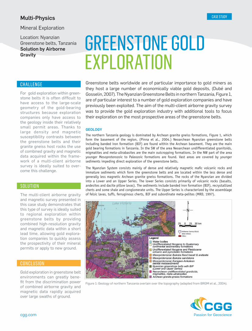
GEOLOGY The northern Tanzania geology is dominated by Archean granite gneiss formations, Figure 1, which form the basement of the region, (Pinna et al., 2004.) Neoarchean Nyanzian greenstone belts including banded iron formation (BIF) are found within the Archean basement. They are the main gold bearing formations in Tanzania. In the SW of the area Neoarchean undifferentiated granitoids, migmatites and meta-ultrabasites are the main outcropping formations. In the NW part of the area younger Mesoproterozoic to Paleozoic formations are found. Vast areas are covered by younger sediments impeding direct exploration of the greenstone belts.
The Nyanzian System consists mainly of dense and relatively magnetic mafic volcanic rocks and immature sediments which form the greenstone belts and are located within the less dense and generally less magnetic Archean granite gneiss formations. The rocks of the Nyanzian are divided into a Lower and an Upper Series. The lower Series consists primarily of volcanic rocks (basalts, andesites and dacite pillow lavas). The sediments include banded iron formation (BIF), recrystallized cherts and some shale and conglomerate units. The Upper Series is characterized by the assemblage of felsic lavas, tuffs, ferruginous cherts, BIF and subordinate meta-pelites (MRD, 1997).
CHALLENGEFor gold exploration within green-stone belts it is often difficult to have access to the large-scale geometry of the gold-bearing structures because exploration companies only have access to the geology inside their relatively small permit areas. Thanks to large density and magnetic susceptibility contrasts between the greenstone belts and their granite gneiss host rocks the use of combined gravity and magnetic data acquired within the frame-work of a multi-client airborne survey is ideally suited to over-come this challenge.
SOLUTIONThe multi-client airborne gravity and magnetic survey presented in this case study demonstrates that this type of survey is ideally suited to regional exploration within greenstone belts by providing combined high-resolution gravity and magnetic data within a short lead time, allowing gold explora-tion companies to quickly assess the prospectivity of their mineral permits or apply to new ground.
CONCLUSIONGold exploration in greenstone belt environments can greatly bene-fit from the discrimination power of combined airborne gravity and magnetic data rapidly acquired over large swaths of ground.
GREENSTONE GOLDEXPLORATIONGreenstone belts worldwide are of particular importance to gold miners as they host a large number of economically viable gold deposits, (Dubé and Gosselin, 2007). The Nyanzian Greenstone Belts in northern Tanzania, Figure 1, are of particular interest to a number of gold exploration companies and have previously been exploited. The aim of the multi-client airborne gravity survey was to provide the gold exploration industry with additional tools to focus their exploration on the most prospective areas of the greenstone belts.
Location: Nyanzian Greenstone belts, Tanzania Solution by Airborne Gravity
Multi-PhysicsMineral Exploration
cgg.com
Figure 1: Geology of northern Tanzania overlain over the topography (adapted from BRGM et al., 2004).
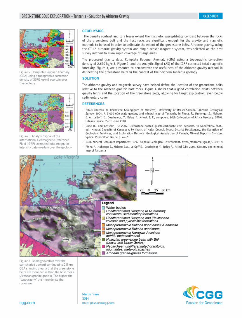
Figure 4. Geology overlain over the sun-shaded upward continued to 2,5 km CBA showing clearly that the greenstone belts are more dense than the host rocks (Archean granite gneiss). The higher the “topography” the more dense the rocks are.
Figure 2. Complete Bouguer Anomaly (CBA) using a topographic correction density of 2670 kg/m3 overlain over the geology.
Figure 3. Analytic Signal of the International Geomagnetic Reference Field (IGRF) corrected total magnetic intensity data overlain over the geology.
cgg.com
GEOPHYSICSTThe density contrast and to a lesser extent the magnetic susceptibility contrast between the rocks of the greenstone belt and the host rocks are significant enough for the gravity and magnetic methods to be used in order to delineate the extent of the greenstone belts. Airborne gravity, using the GT-1A airborne gravity system and single sensor magnetic system, was selected as the best survey method to allow rapid coverage of large areas.
The processed gravity data, Complete Bouguer Anomaly (CBA) using a topographic correction density of 2,670 kg/m3, Figure 2, and the Analytic Signal (AS) of the IGRF-corrected total magnetic intensity, Figure 3, are presented to demonstrate the usefulness of the airborne gravity method in delineating the greenstone belts in the context of the northern Tanzania geology.
SOLUTION
The airborne gravity and magnetic survey have helped define the location of the greenstone belts relative to the Archean granitic host rocks. Figure 4 shows that a good correlation exists between gravity highs and the location of the greenstone belts, allowing for target exploration, even below sedimentary cover.
REFERENCES - BRGM (Bureau de Recherche Géologiques et Minières), University of Dar-es-Salaam, Tanzania Geological
Survey, 2004, A 2 000 000 scale geology and mineral map of Tanzania, in Pinna, P., Muhongo, S., Mcharo, B. A., LeGoff, E., Deschamps, Y., Ralay, F., Milesi, J. P., compliers, 20th Colloquium of Africa Geology, BRGM, Orleans France, 2-7th June 2004
- Dubé B., and Gosselin, P.; 2007. Greenstone-hosted quartz-carbonate vein deposits, in Goodfellow, W.D., ed., Mineral Deposits of Canada: A Synthesis of Major Deposit-Types, District Metallogeny, the Evolution of Geological Provinces, and Exploration Methods: Geological Association of Canada, Mineral Deposits Division, Special Publication No. 5, p. 49-73
- MRD, Mineral Resources Department; 1997. General Geological Environment. http://tanzania.sgu.se/GEO.HTM
- Pinna P., Muhongo S., Mcharo B.A., Le Goff E., Deschamps Y., Ralay F., Milesi J.P.; 2004. Geology and mineral map of Tanzania
Martin [email protected]
GREENSTONE GOLD EXPLORATION – Tanzania – Solution by Airborne Gravity