Embed Size (px)
Citation preview
0361-0128/01/3428/643-29 $6.00 643
The Late Cretaceous Donlin Creek Gold Deposit, Southwestern Alaska: Controls on Epizonal Ore Formation
RICHARD J. GOLDFARB,†
U.S. Geological Survey, Box 25046, Denver Federal Center, Denver, Colorado 80225
ROBERT AYUSO, U.S. Geological Survey, 12201 Sunrise Valley Drive, Mail Stop 954, Reston, Virginia 20192
MARTI L. MILLER, U.S. Geological Survey, 4200 University Drive, Anchorage, Alaska 99508-4667
SHANE W. EBERT, Mineral Deposit Research Unit, Department of Earth and Ocean Sciences, University of British Columbia, 6339 Stores Road, Vancouver,
British Columbia V6T 1Z4
ERIN E. MARSH, U.S. Geological Survey, Box 25046, Denver Federal Center, Denver, Colorado 80225
SCOTT A. PETSEL, NovaGold Resources Inc., 4420 Taku Blvd., Juneau, Alaska 99801
LANCE D. MILLER,Juneau Economic Development Council, 612 W. Willoughby, Juneau, Alaska 99801
DWIGHT BRADLEY, U.S. Geological Survey, 4200 University Drive, Anchorage, Alaska 99508-4667
CRAIG JOHNSON,U.S. Geological Survey, Box 25046, Denver Federal Center, Denver, Colorado 80225
AND WILLIAM MCCLELLAND
Department of Geological Sciences, University of Idaho, Moscow, Idaho 83844
AbstractThe Donlin Creek gold deposit, southwestern Alaska, has an indicated and inferred resource of approxi-
mately 25 million ounces (Moz) Au at a cutoff grade of 1.5 g/t. The ca. 70 Ma deposit is hosted in the Late Cre-taceous Kuskokwim flysch basin, which developed in the back part of the arc region of an active continentalmargin, on previously accreted oceanic terranes and continental fragments. A hypabyssal, mainly rhyolitic to
† Corresponding author: email, [email protected]
©2004 by Economic Geology, Vol. 99, pp. 643–671
Economic GeologyBULLETIN OF THE SOCIETY OF ECONOMIC GEOLOGISTS
VOL. 99 June–July 2004 NO. 4
©2004 by Economic GeologyVol. 99, pp. 0000–0000
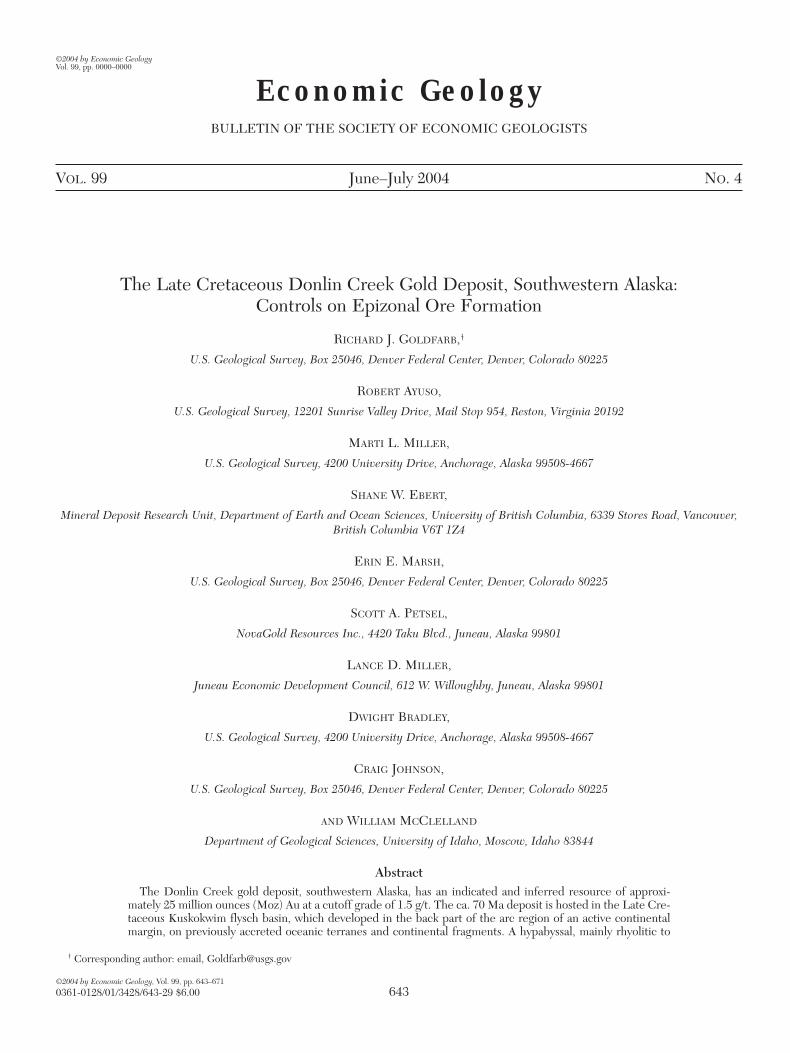
IntroductionTHE DONLIN CREEK gold deposit is a recently defined low-grade, large-tonnage resource in the Kuskokwim Mountainsof southwestern Alaska (Fig. 1). The deposit is located about450 km west-northwest of Anchorage and 20 km from theKuskokwim River. The indicated and inferred resource hasbeen recently increased to 25.4 Moz Au at a 1.5 g/t Au cutoffgrade (Placer Dome press release, 4/9/03). The resource isopen at depth and along strike. Low gold prices, the refrac-tory nature of the potential ore, and the relatively remotelocation have collectively hindered development of the prop-erty to date. Nevertheless, the property represents a world-class gold resource of great interest and the largest lode golddeposit in the northern Cordillera of western North America.
The Kuskokwim Mountains region (Figs. 1–2A) is charac-terized by rolling hills that reach maximum elevations of1,000 m. The dominant bedrock is very weakly metamor-phosed Upper Cretaceous basin fill, which is widely intrudedby Late Cretaceous to earliest Tertiary igneous rocks (Figs. 1,3). Mineral production in this region has historically beenfrom scattered placer gold accumulations that have yieldedalmost 3.5 Moz Au (Bundtzen and Miller, 1997; Swainbank etal., 2001). Almost one-half of this placer production has comefrom the Iditarod district, where the auriferous quartz veinsof the Golden Horn deposit, hosted by the Black Creek stock,provided a significant lode source (Bull, 1988).
Three general groups of metallic ore deposits are recog-nized in this region (Fig.1): (1) small, epithermal mercury-antimony deposits (e.g., Red Devil) that cut Cretaceous clas-tic rocks and mafic dikes (Sainsbury and MacKevett, 1965;
644 GOLDFARB ET AL.
0361-0128/98/000/000-00 $6.00 644
rhyodacitic, and commonly porphyritic, 8- × 3-km dike complex, part of a regional ca. 77 to 58 Ma magmaticarc, formed a structurally competent host for the mineralization. This deposit is subdivided into about onedozen distinct prospects, most of which consist of dense quartz ± carbonate veinlet networks that fill north-northeast–striking extensional fractures in the northeast-trending igneous rocks. The sulfide mineral assem-blage is dominated by arsenopyrite, pyrite, and, typically younger, stibnite; gold is refractory within the ar-senopyrite. Sericitization, carbonatization, and sulfidation were the main alteration processes.
Fluid inclusion studies of the quartz that hosts the resource indicate dominantly aqueous ore fluids with alsoabout 3 to 7 mol percent CO2 ± CH4 and a few tenths to a few mole percent NaCl + KCl. The gold-bearingfluids were mainly homogeneously trapped at approximately 275° to 300°C and at depths of 1 to 2 km. Someof the younger stibnite may have been deposited by late-stage aqueous fluids at lower temperature. Measuredδ18O values for the gold-bearing quartz range between 11 and 25 per mil; the estimated δ18O fluid values rangefrom 7 to12 per mil, suggesting a mainly crustally derived fluid. A broad range of measured δD values for hy-drothermal micas, between –150 and –80 per mil, is suggestive of a contribution from devolatilization of or-ganic matter and/or minor amounts of mixing with meteoric fluids. Gold-associated hydrothermal sulfide min-erals are characterized by δ34S values mainly between –16 and –10 per mil, with the sulfur derived fromdiagenetic pyrite and organic matter within the flysch basin. A smaller group of δ34S measurements, whichshows values as depleted as –27 per mil, suggests a different local sulfur reservoir in the basin for the later hy-drothermal episode dominated by stibnite. Initial εNd of –8.7 to –3.1 and 87Sr/86Sr measurements of 0.706 to0.709 for the ore-hosting dikes also indicate a crustal reservoir for some of the Late Cretaceous magmatism.Overlapping lead isotope data for these intrusive rocks and for sulfide minerals suggest a crustal contributionfor the lead in both.
Copper- and gold-bearing stockwork veinlets in hornfels occur at Dome, a prospect located at the north-ern end of the Donlin Creek deposit. These stockworks are cut by the younger auriferous gold veins that de-fine the main Donlin Creek gold mineralization. Highly saline, gas-rich, heterogeneously trapped fluids de-posited the stockworks at temperatures approximately 100°C hotter than those of the main gold-formingevent at Donlin Creek. The genetic relationship of the Dome prospect to the main Donlin Creek gold re-source is equivocal.
The epizonal Donlin Creek deposit shows affinities to the gold systems interpreted by various workers asorogenic or intrusion related; it shows important differences from typical epithermal and Carlin-like deposits.The ore-forming fluids were derived by either broad-scale metamorphic devolatilization above rising mantlemelts or exsolution from a magma that was dominated by a significant flysch melt component.
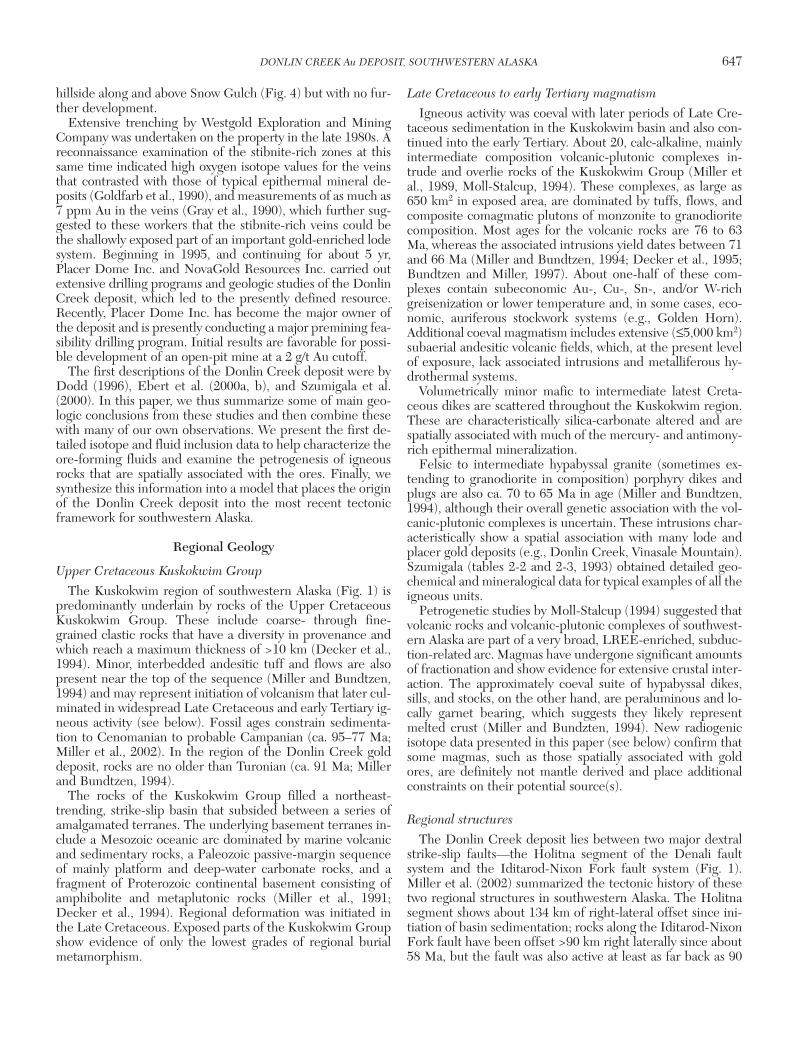
159°156° 153°64°
63°
62°
61°
JCDonlin
GHCM
RDBM
GR
Kusko
kwim
MedfraOphir
Iditarod
Sleetmute
Area offigure 3
Igneous rocks(Cretaceous toTertiary)
Quaternarysediments
Kuskokwim Gr.(Cretaceous)
Lower Paleozoicbasement rocks
Denalifault
Iditarod-Nixon Forkfau
lt
Holitna segment
GCAlaska Range
DRF
YGNF
Mtns
.
25 km
KuskokwimR.
McGrath
Alaska
Areaof map
V
FIG. 1. Location of the Donlin Creek gold deposit, Kuskokwim region,southwestern Alaska. Other metallic mineral deposits in the region include(1) epithermal mercury-antimony deposits at Red Devil (RD) and Barome-ter Mountain (BM); (2) other gold-rich stockworks and veins at Golden Horn(GH), Chicken Mountain (CM), Ganes-Yankee Creek (YG), Julian Creek(JC), Granite Creek (GC), Vinasale (V), Stuyahok (not shown; 200 km SW ofDonlin Creek), and Gold Run (GR); and (3) calcic, gold-rich copper skarnsat Nixon Fork (NF). After Miller et al. (2002).
DONLIN CREEK Au DEPOSIT, SOUTHWESTERN ALASKA 645
0361-0128/98/000/000-00 $6.00 645
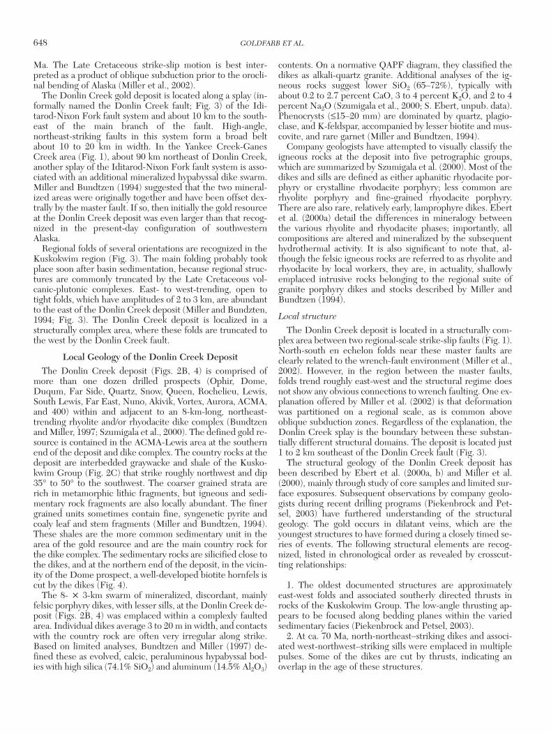
AB
C
F
G H
E
D
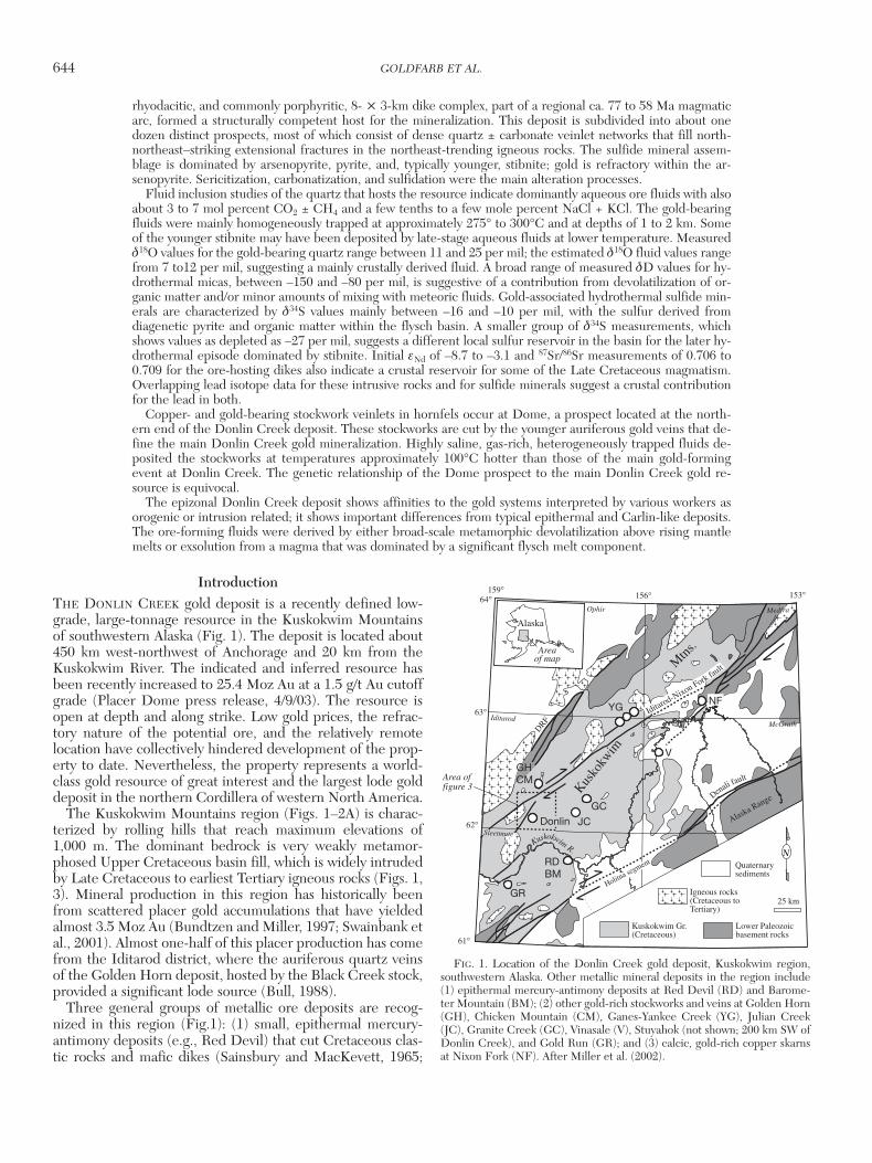
FIG. 2. A. Overview photo of the Donlin Creek deposit area that is centered on a series of topographic domes in the rollinghills that define the Kuskokwim Mountains of southwestern Alaska. B. Most of the mineralization at the Donlin Creek golddeposit occurs in a series of drilled prospects within an 8-km-long, NNE-trending igneous dike complex. The gold resourceis located in the more southerly prospects. C. Typical rhythmically banded siltstone and graywacke of the Kuskokwim Group,which is the country rock to the dike complex. D. Early, thin pyrite veinlet cutting rhyodacite porphyry. E. Quartz vein withgold-bearing arsenopyrite selvage cutting earlier pyrite vein. F. Late vein with realgar, native arsenic, and stibnite that over-prints earlier auriferous arsenopyrite event. G. Graphite clots in coarse-grained rhyodacite host that often give a bluish tingeto the intrusive rocks. H. Typical rhyodacite host rock with strong ankerite (top) and kaolinite (bottom) alteration. Some ofthe photos reproduced from unpublished report of Piekenbrock and Petsel (2003).
Gray et al., 1997); (2) gold-rich stockworks and veins that arehosted by multiphase volcanic-plutonic complexes (e.g.,Golden Horn) or are spatially associated with granite por-phyry dikes (e.g., Donlin Creek) or stocks (e.g., VinasaleMountain, Shotgun), which intrude the clastic sequence(Bundtzen and Miller, 1997); and (3) calcic, gold-rich copperskarns (e.g., Nixon Fork) where plutons intrude adjacent car-bonate platform rocks in allochthonous terrane blocks (New-berry et al., 1997). The specific genetic associations betweenall three groups of deposits, as well as the igneous rocks, re-main enigmatic, although all ore systems and much of themagmatism reflect an important broad thermal event insouthwestern Alaska at ca. 70 Ma (Bundtzen and Miller, 1997;Goldfarb, 1997; Miller et al., 2002). An obvious possibility isthat the epithermal mercury-antimony deposits of theKuskokwim Mountains may be distal parts of zoned, gold-richhydrothermal systems.
Small-scale placer mining along Crooked Creek (Fig. 4),downstream from the newly defined Donlin Creek lode re-source, has taken place intermittently for almost 100 yr (e.g.,Cady et al., 1955) but with total production of <50,000 oz Au(Ebert et al., 2000b). The gold from these placers has thehighest average fineness among any of the placers in this partof southwestern Alaska (approx 940; Bundtzen et al., 1985).Discontinuous, thin quartz-calcite veins, some associatedwith massive stibnite, were historically prospected on the
646 GOLDFARB ET AL.
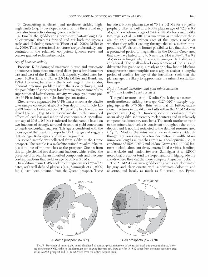
0361-0128/98/000/000-00 $6.00 646
Kuskokwim Group
Iditarod Volcanics
Felsic intrusive rocks
62° 15’
Iditarod-N
ixon ForkFault
Donlin
Cr. Fault
Area offigure 4
65
3533
2768
35
35
60
7850
38
484545
3545
40
45
5445
45
10 km
62° 00’158° 20’ 158° 00’
25
62
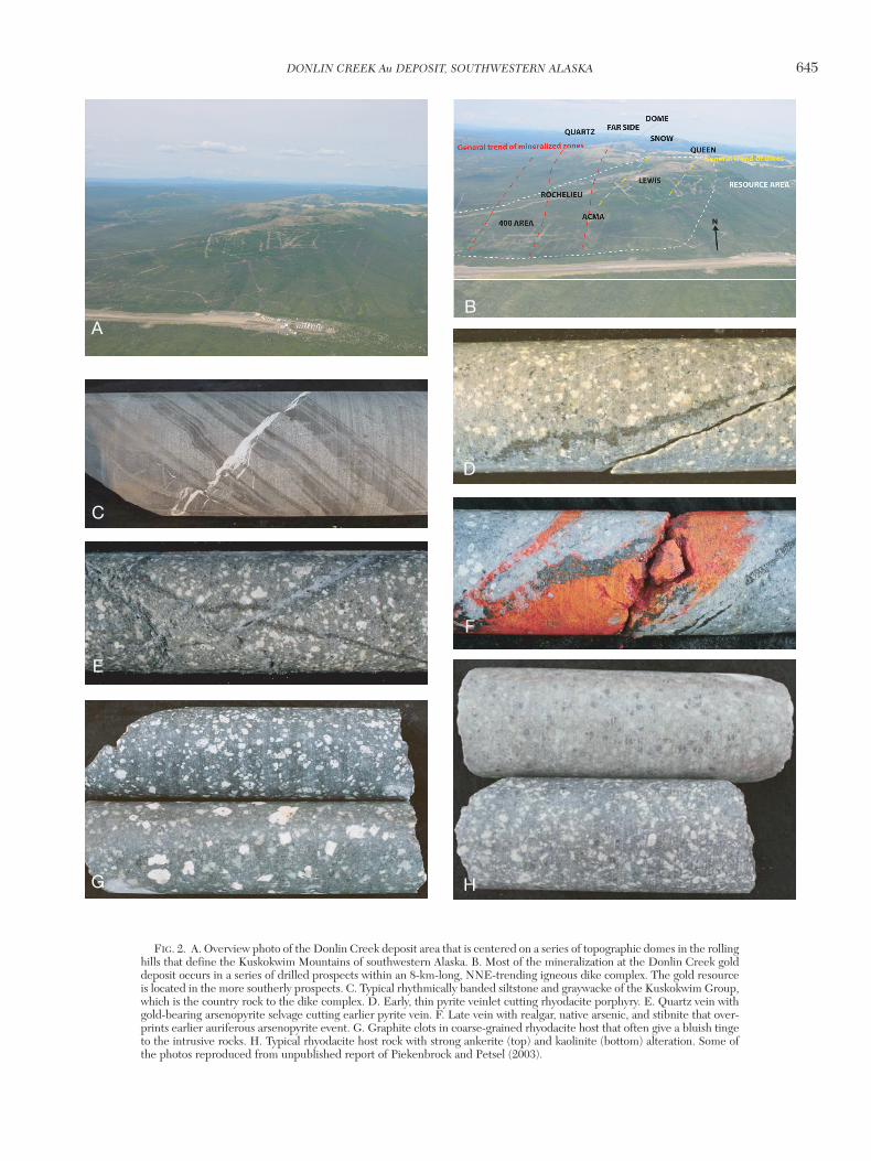
FIG. 3. Local geology of the area surrounding the Donlin Creek deposit,southwestern Alaska, after mapping of Miller and Bundtzen (1994). The de-posit occurs in a structurally complex region of the Kuskokwim basin, whereit is hosted by a granite dike complex located a few kilometers to the east ofthe Donlin Creek fault and on the western edge of a series of regional folds.
150
400
400
250
Fault
Thrust fault
Inferred fault
Prominent lineament
Undifferentiated felsicintrusive rocks
Placer mining area
Cretaceous KuskokwimGroup and Quaternarysurficial deposits,undifferentiated
Surface projection ofareas > 1 ppm Au
Cross section, Figure 5
1 km
Contour interval25 meters
Legend
Main DonlinCreek Camp
DonlinCree
k
Cre
ek
Cro
oked
070 Fault
Snow Gulch
Fault
Creek
American
N
Far SideDome
Duqum
Quartz
Snow
Ophir
Queen
Lewis
Far EastS.Lewis
Nuno
Aurora
Akivik
Rochelieu
Vortex
Airstrip
400
Biotitehornfels
Acm
a fault
Vortex
fault
ACMA
A
A'
AA'
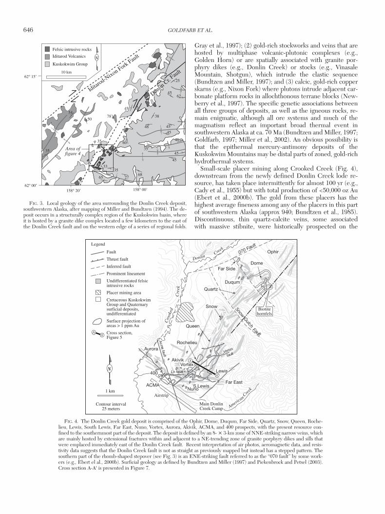
FIG. 4. The Donlin Creek gold deposit is comprised of the Ophir, Dome, Duqum, Far Side, Quartz, Snow, Queen, Roche-lieu, Lewis, South Lewis, Far East, Nuno, Vortex, Aurora, Akivik, ACMA, and 400 prospects, with the present resource con-fined to the southernmost part of the deposit. The deposit is defined by an 8- × 3-km zone of NNE-striking narrow veins, whichare mainly hosted by extensional fractures within and adjacent to a NE-trending zone of granite porphyry dikes and sills thatwere emplaced immediately east of the Donlin Creek fault. Recent interpretation of air photos, aeromagnetic data, and resis-tivity data suggests that the Donlin Creek fault is not as straight as previously mapped but instead has a stepped pattern. Thesouthern part of the rhomb-shaped stepover (see Fig. 3) is an ENE-striking fault referred to as the “070 fault” by some work-ers (e.g., Ebert el al., 2000b). Surficial geology as defined by Bundtzen and Miller (1997) and Piekenbrock and Petsel (2003).Cross section A-A' is presented in Figure 7.
hillside along and above Snow Gulch (Fig. 4) but with no fur-ther development.
Extensive trenching by Westgold Exploration and MiningCompany was undertaken on the property in the late 1980s. Areconnaissance examination of the stibnite-rich zones at thissame time indicated high oxygen isotope values for the veinsthat contrasted with those of typical epithermal mineral de-posits (Goldfarb et al., 1990), and measurements of as much as7 ppm Au in the veins (Gray et al., 1990), which further sug-gested to these workers that the stibnite-rich veins could bethe shallowly exposed part of an important gold-enriched lodesystem. Beginning in 1995, and continuing for about 5 yr,Placer Dome Inc. and NovaGold Resources Inc. carried outextensive drilling programs and geologic studies of the DonlinCreek deposit, which led to the presently defined resource.Recently, Placer Dome Inc. has become the major owner ofthe deposit and is presently conducting a major premining fea-sibility drilling program. Initial results are favorable for possi-ble development of an open-pit mine at a 2 g/t Au cutoff.
The first descriptions of the Donlin Creek deposit were byDodd (1996), Ebert et al. (2000a, b), and Szumigala et al.(2000). In this paper, we thus summarize some of main geo-logic conclusions from these studies and then combine thesewith many of our own observations. We present the first de-tailed isotope and fluid inclusion data to help characterize theore-forming fluids and examine the petrogenesis of igneousrocks that are spatially associated with the ores. Finally, wesynthesize this information into a model that places the originof the Donlin Creek deposit into the most recent tectonicframework for southwestern Alaska.
Regional Geology
Upper Cretaceous Kuskokwim Group
The Kuskokwim region of southwestern Alaska (Fig. 1) ispredominantly underlain by rocks of the Upper CretaceousKuskokwim Group. These include coarse- through fine-grained clastic rocks that have a diversity in provenance andwhich reach a maximum thickness of >10 km (Decker et al.,1994). Minor, interbedded andesitic tuff and flows are alsopresent near the top of the sequence (Miller and Bundtzen,1994) and may represent initiation of volcanism that later cul-minated in widespread Late Cretaceous and early Tertiary ig-neous activity (see below). Fossil ages constrain sedimenta-tion to Cenomanian to probable Campanian (ca. 95–77 Ma;Miller et al., 2002). In the region of the Donlin Creek golddeposit, rocks are no older than Turonian (ca. 91 Ma; Millerand Bundtzen, 1994).
The rocks of the Kuskokwim Group filled a northeast-trending, strike-slip basin that subsided between a series ofamalgamated terranes. The underlying basement terranes in-clude a Mesozoic oceanic arc dominated by marine volcanicand sedimentary rocks, a Paleozoic passive-margin sequenceof mainly platform and deep-water carbonate rocks, and afragment of Proterozoic continental basement consisting ofamphibolite and metaplutonic rocks (Miller et al., 1991;Decker et al., 1994). Regional deformation was initiated inthe Late Cretaceous. Exposed parts of the Kuskokwim Groupshow evidence of only the lowest grades of regional burialmetamorphism.
Late Cretaceous to early Tertiary magmatism
Igneous activity was coeval with later periods of Late Cre-taceous sedimentation in the Kuskokwim basin and also con-tinued into the early Tertiary. About 20, calc-alkaline, mainlyintermediate composition volcanic-plutonic complexes in-trude and overlie rocks of the Kuskokwim Group (Miller etal., 1989, Moll-Stalcup, 1994). These complexes, as large as650 km2 in exposed area, are dominated by tuffs, flows, andcomposite comagmatic plutons of monzonite to granodioritecomposition. Most ages for the volcanic rocks are 76 to 63Ma, whereas the associated intrusions yield dates between 71and 66 Ma (Miller and Bundtzen, 1994; Decker et al., 1995;Bundtzen and Miller, 1997). About one-half of these com-plexes contain subeconomic Au-, Cu-, Sn-, and/or W-richgreisenization or lower temperature and, in some cases, eco-nomic, auriferous stockwork systems (e.g., Golden Horn).Additional coeval magmatism includes extensive (≤5,000 km2)subaerial andesitic volcanic fields, which, at the present levelof exposure, lack associated intrusions and metalliferous hy-drothermal systems.
Volumetrically minor mafic to intermediate latest Creta-ceous dikes are scattered throughout the Kuskokwim region.These are characteristically silica-carbonate altered and arespatially associated with much of the mercury- and antimony-rich epithermal mineralization.
Felsic to intermediate hypabyssal granite (sometimes ex-tending to granodiorite in composition) porphyry dikes andplugs are also ca. 70 to 65 Ma in age (Miller and Bundtzen,1994), although their overall genetic association with the vol-canic-plutonic complexes is uncertain. These intrusions char-acteristically show a spatial association with many lode andplacer gold deposits (e.g., Donlin Creek, Vinasale Mountain).Szumigala (tables 2-2 and 2-3, 1993) obtained detailed geo-chemical and mineralogical data for typical examples of all theigneous units.
Petrogenetic studies by Moll-Stalcup (1994) suggested thatvolcanic rocks and volcanic-plutonic complexes of southwest-ern Alaska are part of a very broad, LREE-enriched, subduc-tion-related arc. Magmas have undergone significant amountsof fractionation and show evidence for extensive crustal inter-action. The approximately coeval suite of hypabyssal dikes,sills, and stocks, on the other hand, are peraluminous and lo-cally garnet bearing, which suggests they likely representmelted crust (Miller and Bundzten, 1994). New radiogenicisotope data presented in this paper (see below) confirm thatsome magmas, such as those spatially associated with goldores, are definitely not mantle derived and place additionalconstraints on their potential source(s).
Regional structures
The Donlin Creek deposit lies between two major dextralstrike-slip faults—the Holitna segment of the Denali faultsystem and the Iditarod-Nixon Fork fault system (Fig. 1).Miller et al. (2002) summarized the tectonic history of thesetwo regional structures in southwestern Alaska. The Holitnasegment shows about 134 km of right-lateral offset since ini-tiation of basin sedimentation; rocks along the Iditarod-NixonFork fault have been offset >90 km right laterally since about58 Ma, but the fault was also active at least as far back as 90
DONLIN CREEK Au DEPOSIT, SOUTHWESTERN ALASKA 647
0361-0128/98/000/000-00 $6.00 647
Ma. The Late Cretaceous strike-slip motion is best inter-preted as a product of oblique subduction prior to the orocli-nal bending of Alaska (Miller et al., 2002).
The Donlin Creek gold deposit is located along a splay (in-formally named the Donlin Creek fault; Fig. 3) of the Idi-tarod-Nixon Fork fault system and about 10 km to the south-east of the main branch of the fault. High-angle,northeast-striking faults in this system form a broad beltabout 10 to 20 km in width. In the Yankee Creek-GanesCreek area (Fig. 1), about 90 km northeast of Donlin Creek,another splay of the Iditarod-Nixon Fork fault system is asso-ciated with an additional mineralized hypabyssal dike swarm.Miller and Bundtzen (1994) suggested that the two mineral-ized areas were originally together and have been offset dex-trally by the master fault. If so, then initially the gold resourceat the Donlin Creek deposit was even larger than that recog-nized in the present-day configuration of southwesternAlaska.
Regional folds of several orientations are recognized in theKuskokwim region (Fig. 3). The main folding probably tookplace soon after basin sedimentation, because regional struc-tures are commonly truncated by the Late Cretaceous vol-canic-plutonic complexes. East- to west-trending, open totight folds, which have amplitudes of 2 to 3 km, are abundantto the east of the Donlin Creek deposit (Miller and Bundzten,1994; Fig. 3). The Donlin Creek deposit is localized in astructurally complex area, where these folds are truncated tothe west by the Donlin Creek fault.
Local Geology of the Donlin Creek DepositThe Donlin Creek deposit (Figs. 2B, 4) is comprised of
more than one dozen drilled prospects (Ophir, Dome,Duqum, Far Side, Quartz, Snow, Queen, Rochelieu, Lewis,South Lewis, Far East, Nuno, Akivik, Vortex, Aurora, ACMA,and 400) within and adjacent to an 8-km-long, northeast-trending rhyolite and/or rhyodacite dike complex (Bundtzenand Miller, 1997; Szumigala et al., 2000). The defined gold re-source is contained in the ACMA-Lewis area at the southernend of the deposit and dike complex. The country rocks at thedeposit are interbedded graywacke and shale of the Kusko-kwim Group (Fig. 2C) that strike roughly northwest and dip35° to 50° to the southwest. The coarser grained strata arerich in metamorphic lithic fragments, but igneous and sedi-mentary rock fragments are also locally abundant. The finergrained units sometimes contain fine, syngenetic pyrite andcoaly leaf and stem fragments (Miller and Bundtzen, 1994).These shales are the more common sedimentary unit in thearea of the gold resource and are the main country rock forthe dike complex. The sedimentary rocks are silicified close tothe dikes, and at the northern end of the deposit, in the vicin-ity of the Dome prospect, a well-developed biotite hornfels iscut by the dikes (Fig. 4).
The 8- × 3-km swarm of mineralized, discordant, mainlyfelsic porphyry dikes, with lesser sills, at the Donlin Creek de-posit (Figs. 2B, 4) was emplaced within a complexly faultedarea. Individual dikes average 3 to 20 m in width, and contactswith the country rock are often very irregular along strike.Based on limited analyses, Bundtzen and Miller (1997) de-fined these as evolved, calcic, peraluminous hypabyssal bod-ies with high silica (74.1% SiO2) and aluminum (14.5% Al2O3)
contents. On a normative QAPF diagram, they classified thedikes as alkali-quartz granite. Additional analyses of the ig-neous rocks suggest lower SiO2 (65–72%), typically withabout 0.2 to 2.7 percent CaO, 3 to 4 percent K2O, and 2 to 4percent Na2O (Szumigala et al., 2000; S. Ebert, unpub. data).Phenocrysts (≤15–20 mm) are dominated by quartz, plagio-clase, and K-feldspar, accompanied by lesser biotite and mus-covite, and rare garnet (Miller and Bundtzen, 1994).
Company geologists have attempted to visually classify theigneous rocks at the deposit into five petrographic groups,which are summarized by Szumigala et al. (2000). Most of thedikes and sills are defined as either aphanitic rhyodacite por-phyry or crystalline rhyodacite porphyry; less common arerhyolite porphyry and fine-grained rhyodacite porphyry.There are also rare, relatively early, lamprophyre dikes. Ebertet al. (2000a) detail the differences in mineralogy betweenthe various rhyolite and rhyodacite phases; importantly, allcompositions are altered and mineralized by the subsequenthydrothermal activity. It is also significant to note that, al-though the felsic igneous rocks are referred to as rhyolite andrhyodacite by local workers, they are, in actuality, shallowlyemplaced intrusive rocks belonging to the regional suite ofgranite porphyry dikes and stocks described by Miller andBundtzen (1994).
Local structure
The Donlin Creek deposit is located in a structurally com-plex area between two regional-scale strike-slip faults (Fig. 1).North-south en echelon folds near these master faults areclearly related to the wrench-fault environment (Miller et al.,2002). However, in the region between the master faults,folds trend roughly east-west and the structural regime doesnot show any obvious connections to wrench faulting. One ex-planation offered by Miller et al. (2002) is that deformationwas partitioned on a regional scale, as is common aboveoblique subduction zones. Regardless of the explanation, theDonlin Creek splay is the boundary between these substan-tially different structural domains. The deposit is located just1 to 2 km southeast of the Donlin Creek fault (Fig. 3).
The structural geology of the Donlin Creek deposit hasbeen described by Ebert et al. (2000a, b) and Miller et al.(2000), mainly through study of core samples and limited sur-face exposures. Subsequent observations by company geolo-gists during recent drilling programs (Piekenbrock and Pet-sel, 2003) have furthered understanding of the structuralgeology. The gold occurs in dilatant veins, which are theyoungest structures to have formed during a closely timed se-ries of events. The following structural elements are recog-nized, listed in chronological order as revealed by crosscut-ting relationships:
1. The oldest documented structures are approximatelyeast-west folds and associated southerly directed thrusts inrocks of the Kuskokwim Group. The low-angle thrusting ap-pears to be focused along bedding planes within the variedsedimentary facies (Piekenbrock and Petsel, 2003).
2. At ca. 70 Ma, north-northeast–striking dikes and associ-ated west-northwest–striking sills were emplaced in multiplepulses. Some of the dikes are cut by thrusts, indicating anoverlap in the age of these structures.
648 GOLDFARB ET AL.
0361-0128/98/000/000-00 $6.00 648
3. Crosscutting northeast- and northwest-striking high-angle faults (Fig. 4) developed soon after the thrusts and mayhave also been active during igneous activity.
4. Finally, the gold-bearing north-northeast–striking (Fig.5) extensional fractures formed and cut both the igneousrocks and all fault generations (Ebert et al., 2000a; Miller etal., 2000). These extensional structures are preferentially con-centrated in the relatively competent igneous rocks andcoarser grained sedimentary rocks.
Age of igneous activity
Previous K-Ar dating of magmatic biotite and muscovitephenocrysts from three unaltered dikes, just a few kilometerseast and west of the Donlin Creek deposit, yielded dates be-tween 70.9 ± 2.1 and 65.1 ± 2.0 Ma (Miller and Bundzten,1994). However, because of the broad range in these dates,inherent precision problems with the K-Ar technique, andthe possibility of some argon loss from magmatic minerals bysuperimposed hydrothermal activity, we employed more pre-cise U-Pb techniques for absolute age constraints.
Zircons were separated for U-Pb analysis from a rhyodacitedike sample collected at about a 5-m depth in drill hole LT-96-33 from the Lewis prospect. Three of the five fractions an-alyzed (Table 1, Fig. 6) are discordant due to the combinedeffects of lead loss and inherited components. A crystalliza-tion age of 69.2 ± 0.5 Ma is inferred for this sample based ontwo fractions of strongly abraded zircon that yield concordantto nearly concordant analyses. This age is consistent with theolder age of the previously reported K-Ar range and suggeststhat younger K-Ar ages could reflect argon loss.
A second sample was collected from a dike at the Domeprospect. The sample is a malachite-stained rhyolite dike ex-posed in one of the trenches at the prospect. Zircons fromthis sample yielded two discordant fractions, which reflect thepresence of Precambrian inherited components and two con-cordant fractions that yield an age of 66.5 ± 0.5 Ma.
In addition to our U-Pb work, recent igneous rock 40Ar/39Ardates, with well-defined plateaus (e.g., Szumigala et al., 2000,fig. 4) have been obtained from the Queen prospect. These
include a biotite plateau age of 70.3 ± 0.2 Ma for a rhyoliteporphyry dike, as well as a biotite plateau age of 72.6 ± 0.9Ma, and a whole-rock age of 74.4 ± 0.8 Ma for a mafic dike(Szumigala et al., 2000). It is uncertain as to whether theseare the true crystallization ages of the igneous rocks orwhether they reflect cooling through the mica closure tem-peratures. We favor the former possibility; i.e., that there wasa protracted period of magmatism in the Donlin Creek areathat may have lasted for 3 to 5 m.y. (ca. 74.4 ± 0.8–70.3 ± 0.2Ma) or even longer when the above younger U-Pb dates areconsidered. The shallow-level emplacement of the sills anddikes into low-grade (e.g., already at or below biotite blockingtemperatures) metamorphic rocks argues against a lengthyperiod of cooling for any of the intrusions, such that theplateau ages are likely to approximate the mineral crystalliza-tion ages.
Hydrothermal alteration and gold mineralization within the Donlin Creek resource
The gold resource at the Donlin Creek deposit occurs innorth-northeast–striking (average 012°–020°), steeply dip-ping (generally >70°SE), thin veins that fill brittle, exten-sional fractures in the dikes and sills within the ACMA-Lewisprospect area (Fig. 7). However, some mineralization doesoccur along dike-sedimentary rock contacts and in relativelycompetent sedimentary rock beds. The north-northeast trendto the mineralized veins is consistent throughout the entiredeposit and is not just restricted to the defined resource area(Fig. 5). Most of the veins are a few centimeters wide, al-though rare veins may be a few decimeters in width. Maxi-mum vein lengths in trenches are 7 m. Local epizonal (i.e., atconditions of 150°–300°C and <6 km; Groves et al., 1998) fea-tures include abundant drusy quartz-lined cavities, banding,and cockade and bladed textures. Szumigala et al. (2000)noted that ore zones tend to steepen and form high-grade oreshoots where they cut the more competent igneous rocks.
The ACMA-Lewis area gold-bearing veins are dominatedby gray and clear quartz, with subordinate dolomite andankerite, and locally as much as 5 percent illite. Pyrite,
DONLIN CREEK Au DEPOSIT, SOUTHWESTERN ALASKA 649
0361-0128/98/000/000-00 $6.00 649
65 4 3 2
1
1
1
11
1
13
2
020°, 87° SEN N 012°, 87° SE
11
23
45
2
A. Acma prospect (n= 832) B. All prospects (n = 2478)
5
FIG. 5. Stereonet of mineralized veins, displayed as contour plots in percent of points per each one percent of area, show-ing the strong NNE strike to the dominant ore-bearing fracture set. Data are for (A) 832 veins from the main resource areaat the ACMA prospect and (B) 2,478 veins over the entire deposit area.
650 GOLDFARB ET AL.
0361-0128/98/000/000-00 $6.00 650
TABLE 1. U-Pb Isotope Zircon Data and Apparent Ages
Fraction size1 Wt Concentration(µm) (mg) (ppm) Isotopic composition3 Apparent ages4 (Ma) Th-corrected ages5 (Ma)
206Pb 206Pb 206Pb 206Pb* 207Pb* 207Pb* 206Pb* 207Pb*U Pb*2 204Pb 207Pb 208Pb 238U 235U 206Pb* 238U 206Pb*
Sample 96AM105 Lewis prospect, rhyodacite dikea 45-63 0.1 944 10.7 8,080 ± 19 17.171 17.208 76.0 89.6 ± 0.2 470 76.0 ± 0.2 467 ± 2b 63-80A 0.2 1,076 10.6 10,445 ± 20 19.835 18.592 66.7 68.9 ± 0.1 148 66.8 ± 0.1 146 ± 2c 80-100A 0.2 966 9.5 9,808 ± 21 20.024 19.713 66.8 68.3 ± 0.1 121 66.9 ± 0.1 118 ± 2d 100-350A 0.2 906 9.2 9,638 ± 17 20.383 18.309 69.0 69.2 ± 0.1 76 69.0 ± 0.1 73 ± 2e 100-350A 0.2 873 8.9 9,929 ± 18 20.429 18.704 69.1 69.2 ± 0.1 73 69.2 ± 0.1 70 ± 2
Sample 96AM106 Dome prospect, rhyolite dikea 45-63 0.1 835 8.4 6,868 ± 17 19.596 18.263 68.4 70.5 ± 0.2 143 68.5 ± 0.1 140 ± 3b 63-80A 0.2 86 9.9 3,875 ± 6 11.135 8.852 690.1 864.5 ± 1.8 1,343 690.2 ± 1.3 1,342 ± 1c 80-100A 0.2 646 6.2 5,481 ± 7 19.958 20.842 66.2 66.4 ± 0.1 71 66.3 ± 0.1 68 ± 2d 100-350A 0.2 723 7.0 11,425 ± 48 20.527 25.370 66.4 66.5 ± 0.2 71 66.5 ± 0.1 68 ± 3
1 a, b, etc. designate conventional multigrain fractions; A designates fractions abraded to 30 to 60% of original mass; zircon fractions are nonmagnetic onFrantz magnetic separator at 1.8 amps, 15° forward slope, and side slope of 1°
2 Pb* is radiogenic Pb3 Reported ratios corrected for fractionation (0.125 ± 0.038%/amu) and spike Pb; ratios used in age calculation were adjusted for 2 pg of blank Pb with
isotopic composition of 206Pb/204Pb = 18.6, 207Pb/204Pb = 15.5, and 208Pb/204Pb = 38.4, 2 pg of blank U, 0.25 ± 0.049%/amu fractionation for UO2, and initialcommon Pb with isotopic composition approximated from Stacey and Kramers (1975) with an assigned uncertainty of 0.1 to initial 207Pb/204Pb ratio
4 Uncertainties reported as 2σ; error assignment for individual analyses follows Mattinson (1987) and is consistent with Ludwig (1991); an uncertainty of0.2% is assigned to the 206Pb/238U ratio based on our estimated reproducibility unless this value is exceeded by analytical uncertainties; calculated uncer-tainty in the 207Pb/206Pb ratio incorporates uncertainty due to measured 204Pb/206Pb and 207Pb/206Pb ratios, initial 207Pb/204Pb ratio, and composition andamount of blank; linear regression of discordant data utilized Ludwig (1992); decay constants used: 238U = 1.5513 E-10, 235U = 9.8485 E-10, 238U/235U =137.88
5 A 75 ± 25% efficiency in 230Th exclusion during zircon crystallization is assumed and 207Pb/206Pb and 206Pb/238U ratios have been adjusted accordingly;age assignments presented are derived from the Th-corrected ratios
69.2 ± 0.5 Ma68
72
76
84
80
88
70
69
a
cd
d
e
e
Lewis Dike
A. 96AM105
0.074
0.01
10.
014
0.090
b
U23
820
6 Pb
/
235U207Pb /
0.01
030.
0110
U23
820
6 Pb
/
66.5 ± 0.5 Ma66
68
70
d
a
c
Dome Dike
B. 96AM106
FIG. 6. U-Pb concordia diagram for zircons from least altered rhyodaciteand rhyolite dike samples from the Lewis and Dome prospects at the DonlinCreek gold deposit. A thorium-corrected age of 69.2 ± 0.5 Ma is interpretedas representative of time of preore dike emplacement at Lewis, whereas theage for the Dome dike is 66.5 ± 0.5 Ma. Letters a, b, c, d, and e refer to dif-ferent zircon fractions. Data for fraction b, sample 96AM106, have not beenincluded.
0.01
030.
0110
U23
820
6 Pb
/
66.5 ± 0.5 Ma66
68
70
d
a
c
Dome Dike
B. 96AM106
0.068 0.072235U207Pb /
200
100
300
Ele
vatio
n, m
UTM 541550E
UTM541850E
100 mDonlin Creek
Lewis Section 5100NE
WNW ESE
A A'
400DC98-5
33
DC96-1
95
DR96-3
24
DC98-4
76
DC96-2
30
DC96-1
94
Undifferentiated aphanitic andcrystalline porphyritic rhyodacite
Fine-grained porphyritic rhyodacite
Mafic dike
Undifferentiated greywacke, siltstone,and shale of the Kuskowim Group
Simplified outline of zones with> 2 ppm Au
DrillholeDC98-533
DC
95-178
FIG. 7. A cross section at 5100NE through the Lewis prospect, showingthe slight discordance between ore zones (>2 ppm Au) and the dike/sill com-plex. Figure generalized from Ebert et al. (2000a-b). Location of sectionshown in Figure 4.
arsenopyrite, and stibnite are the dominant sulfide mineralsand may comprise as much as 3 to 5 percent of the gold-richzones. Some pyrite occurs as relatively early, low-grade, thinveinlets (Fig. 2D), with only minor quartz and ankerite, whichare then cut by the auriferous and arsenopyrite-bearingquartz veins (Fig. 2E). The sulfide minerals are relatively finegrained, generally <50 µm in diameter, and gold-bearing ar-senopyrite typically occurs as needles. Stibnite is locally pre-sent as coarse laths that exceed 1 cm in length (particularly inthe area between Snow and ACMA-Lewis), but it more typi-cally appears as late open-space fillings and fracture coatings.Some of these late fractures also contain crystalline realgar,orpiment, and rare native arsenic (Fig. 2F). Minor cinnabarand fine-grained graphite are present, most commonly ob-served locally in paragenetically late thin veins or in alteredrhyodacite and/or rhyolite porphyries. In places, largegraphite clots give a bluish color to the porphyries (Fig. 2G).
The gold in the main Donlin Creek resource occurs almostexclusively as a refractory phase within arsenopyrite. Fine-grained arsenopyrite (<20 µm) averages 40 ppm Au, whereascoarser grained arsenopyrite (>50 µm) has a mean value of 15ppm Au; pyrite grains typically contain 0.1 to 1.0 ppm Au andare not an important component of the overall gold resourceat Donlin Creek (Placer Dome Inc., unpub. company report).Very rare visible gold has been noted in core samples fromthe Far Side prospect (Stan Dodd, oral commun., 1997). Theveins defining the gold resource have a very consistent Ag-As-Au-Hg-Sb geochemical signature. Bundtzen and Miller (1997)note that 24 mineralized samples from the deposit averaged3.2 ppm Au, 2.7 ppm Ag, 2.38 ppm Hg, 664 ppm As, and3,500 ppm Sb. More than 2,800 samples containing >2 ppmAu were described as averaging 5.67 ppm Au, 1.89 ppm Ag,4,369 ppm As, 140 ppm Sb, and 3.76 ppm Hg (Ebert et al.,2000a). Copper and lead concentrations are in the tens ofparts per million, and zinc ranges between 100 and 200 ppmfor samples from most prospects. Data from the above stud-ies, as well as unpublished company data, indicate that, incontrast to many intrusion-related gold deposits (e.g.,Thompson et al., 1999; Lang and Baker, 2001), the DonlinCreek ores are not anomalous in Bi, Te, or W.
Hydrothermal alteration is well developed where the orezones are hosted in igneous rocks. Sericitization (fine-grainedmuscovite + illite) of porphyries is the most obvious alterationfeature, although where the rare mafic dikes are mineralizedfuchsite becomes the dominant mica, and hydrothermal bi-otite is present in altered porphyries at the Dome prospect.Carbonatization (Fig. 2H) and sulfidation of host rocks aretypical, and where this includes disseminated arsenopyrite,the altered rock adjacent to the gold-bearing veins is also au-riferous. Locally, hydrothermal kaolinite (Fig. 2H) and chlo-rite and/or smectite may be abundant within the sericiticallyand clay-altered wall rock. In contrast to the igneous rocks,there is little visible alteration of the mineralized sedimentaryrocks.
Timing of mineralization has been broadly constrained by40Ar/39Ar dating of the hydrothermal sericite. Gray et al.(1997) reported an age of 69.5 ± 1.1 Ma for the gold-formingevent at the Snow prospect. Szumigala et al. (2000) indicatednumerous dates on sericite of between 73.6 ± 0.6 and 67.8 ±0.3 Ma at the Queen and Lewis prospects. These ages suggest
the gold deposition occurred within a few million years of em-placement of the ca. 75 to 69 Ma dikes and sills at DonlinCreek. Present data do not allow us to discriminate whethermagmatism and gold-depositing hydrothermal activity wereessentially coeval (e.g., within a few hundred thousand yearsof each other) or temporally distinct (e.g., separated by about2–3 m.y.).
Mineralization at the Dome prospect
Base metal sulfide minerals are uncommon within theDonlin Creek deposit, except in the vicinity of the Domeprospect where disseminated chalcopyrite and stockworks ofchalcopyrite-bearing quartz veinlets are recognized in boththe porphyries and hornfels. Although not a contributor tothe present Donlin Creek deposit resource, the Domeprospect commonly contains disseminated arsenopyrite andassociated anomalous gold, at least some of which representsoverprinting of the copper-depositing hydrothermal event bythe younger Donlin Creek main-stage mineralization. How-ever, scanning electron microscopy reveals that some of thegold at Dome occurs as grains of electrum, 5 to 40 µm in size,and is closely associated with native bismuth and bismuth-bearing tellurides and selenides.
The geochronologic data contradict the field observations atDome. Whereas the crosscutting relationships indicate Domemineralization predates deposition of the main Donlin Creekgold resource, previous absolute dating does not confirm thisobservation. Determined 40Ar/39Ar dates of Szumigala et al.(2000) for sericite from the Dome veins are 68.0 ± 1.0 and65.1 ± 0.9 Ma, which are younger than their argon dates onthe sericite from the main gold resource. These dates are,however, in general agreement with our 66.5 Ma U-Pb datefor the exposed dike from the Dome trench. We interpretthese data to suggest that some granite porphyry magmatismcontinued until at least 66.5 Ma on the northern boundary ofthe Donlin Creek deposit and that this youngest magmatismmay have led to argon loss and a resetting of the parageneti-cally earliest (i.e., ca. ≥74–68 Ma) hydrothermal micas atDome. The hornfels event at Dome must, therefore, be atleast as old as this ≥74 to 68 Ma initial hydrothermal activity.
Fluid Inclusion Investigations
Previous studies
A reconnaissance fluid inclusion investigation was con-ducted on the Donlin Creek veins during initial explorationactivities (Dunne, 1993). Four samples were examined fromthe Lewis and Far Side prospects. Dunne (1993, p. 2) notedthat the fluid inclusions were “generally <2 to 3 microns whichmake them unsuitable for microthermometric work.” The fewtwo-phase inclusions that she was able to measure were char-acterized by homogenization temperatures of 150° to 220°C.Crushing studies of the veins did indicate the presence of CO2in excess of 0.1 mol percent. In addition to these inclusionsthat seemed to be most characteristic of the gold- and sulfidemineral-bearing quartz, examination of earlier plumose-tex-tured quartz caught up in the veins, and believed by Dunne(1993) to be recrystallized, was also carried out. Fluid inclu-sions in this quartz had homogenization temperatures of 210°to 260°C and contained multiple solid daughter phases.
DONLIN CREEK Au DEPOSIT, SOUTHWESTERN ALASKA 651
0361-0128/98/000/000-00 $6.00 651
A second internal company reconnaissance study is de-scribed by Szumigala et al. (2000). Secondary fluid inclusionswere examined from igneous quartz phenocrysts in altered in-trusive rocks at the Rochelieu, Queen, South Lewis, Lewis, andDome prospects. Microscopic examination of the inclusionsfrom the first four of these prospects, interpreted to be gold re-lated, led to the conclusion that they were trapped at about275° to 300°C and were dilute. In contrast, inclusions fromDome were estimated to have been trapped at temperatures inexcess of 400° to 450°C, were hypersaline, and were inter-preted to have been trapped close to their magmatic source.
Present study
We selected 20 quartz vein samples from drill cores for thefluid inclusion measurements. Sample selection was biased toquartz containing an abundance of ore-related sulfide miner-als and/or high gold grades. These samples represent theQueen, Lewis, South Lewis, Far Side, and Dome prospects.The thin veins, which cut and often brecciate host rhyodacitedikes, appear to represent a series of tensional open-spacefillings, with stibnite-realgar-orpiment assemblages occurringalong the latest fractures. As was also noted by Dunne (1993),many inclusions in all sampled veins were no larger than 2 to3 µm in maximum dimension and thus microthermometricmeasurements were not possible in many of the examinedsections. However, we were able to obtain data from abouthalf of these collected samples where slightly larger inclusions(typically 3–5, but sometimes as large 10 µm) were observed.
A Linkam heating and cooling stage was used for the mi-crothermometric measurements of the fluid incluions. In ad-dition, laser Raman spectroscopy was performed on vaporphases in select inclusions in the petroleum geochemistry lab-oratory, U.S. Geological Survey, Reston, Virgina, using aJobin-Yvon Labram HR Raman microprobe. The incidentlaser wavelength was 532 nm, and minimum detection limitswere 0.01 mol percent for N2 and CO2, and 0.03 mol percentfor CH4 and H2S. A few yellowish inclusions were also ana-lyzed with a Dilor SuperLABRAM Raman microprobe at thelaboratory of Geoscience Australia in Canberra at a wave-length of 514.5 nm. Reconnaissance gas-liquid chromatogra-phy at the U.S. Geological Survey in Denver was performedon samples from the Lewis and Dome prospects.
Inclusions have been generally classified on the basis ofphases present at room temperature and phase changes dur-ing heating and cooling. The determination of inclusion para-genesis was regimented by the classification of primary, pseu-dosecondary, and secondary as outlined by Roedder (1984).No inclusion could be absolutely classified as primary. Inclu-sions interpreted as psuedosecondary were observed in trailswithin individual quartz grains or as independent solitary in-clusions or clusters within the quartz grains. Irregular andnecked inclusions were avoided. Where a cluster of inclusionsall had approximately the same microthermometric measure-ments, we recorded only one value for each studied parame-ter; in other words, recorded measurements are for fluid in-clusion assemblages, a group of spatially related inclusionswith identical liquid/vapor ratios and temperatures of phasechanges (e.g., Goldstein and Reynolds, 1994). Trails of sec-ondary inclusions clearly cut quartz grain boundaries in somestudied sections.
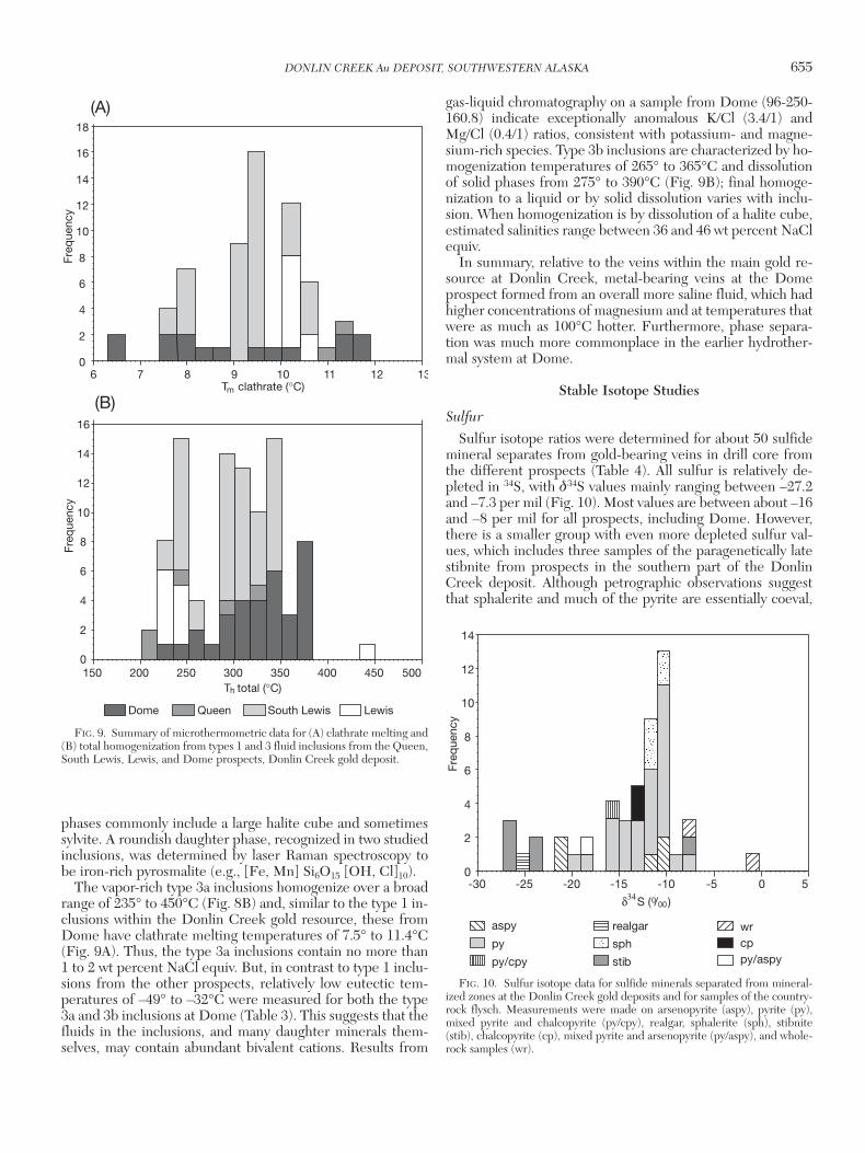
Microthermometric and Raman results
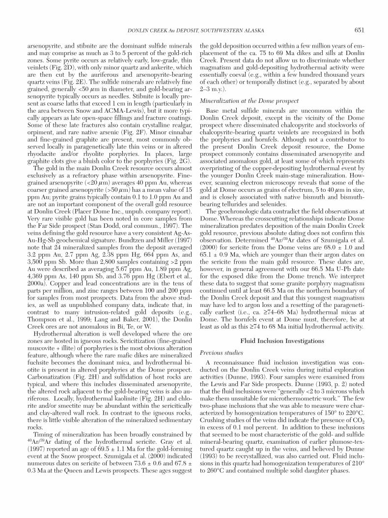
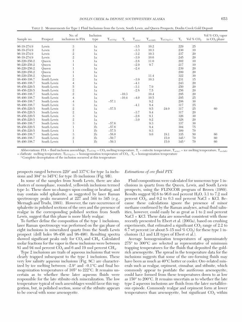
Relatively consistent fluid inclusion measurements charac-terized ore-bearing veins from the Lewis, South Lewis, andQueen prospects (Table 2). The use of a 100× lens allowedclear identification of a carbonic fluid phase in many inclu-sions from all veins. Measured inclusions were typically about3 to 5 µm in diameter. They are best classified as vapor poor(type 1a) and vapor rich (type 1b in South Lewis only)aqueous-carbonic inclusions, and two-phase aqueous (type2) inclusions; the type 1 inclusions were typically present asisolated pseudosecondary inclusions or clusters of inclusions,whereas the type 2 inclusions were commonly in secondarytrails. The type 1 inclusions from South Lewis samples maybe part of a continuum of homogeneously trapped fluids thathave a volume percent vapor of approximately 10 to 30 per-cent in type1a inclusions and 50 to 75 percent in type1b in-clusions (Fig. 8A-B). Despite the broad range in vapor/liquidratio in some vein samples, definitive evidence for fluid im-miscibility is not readily observed. However, the presence ofbladed carbonate in some veins, and observations on addi-tional fluid inclusion sections by one of us (S.E.), suggeststhat heterogeneous trapping may have occurred at sometime.
In two sections from the South Lewis prospect, some type 1fluid inclusions were large enough (e.g., 5 µm) to allow us toclearly observe the freezing of CO2 and subsequent meltingbetween –59.7° and –57.1°C (Table 2). Temperatures of firstmelt in the type 1 inclusions were difficult to measure, but intwo experiments the eutectic temperatures were unequivo-cally observed near –10°C, suggesting a dominance of KClover NaCl. This potassium-rich nature to the fluids is, to alarge degree, compatible with a reconnaissance bulk extrac-tion of fluid inclusions from one gold-bearing quartz samplethat was analyzed by gas-liquid chromatography. AlthoughNa/Cl ratios are 7.4/1 for this analyzed sample from Lewis (96-199-29), a K/Cl ratio of 2.5/1 is also quite significant. It is, forexample, one to two orders of magnitude greater than K/Cl ra-tios for intrusion-related gold deposits from eastern Alaskaand Yukon (e.g., Dublin Gulch, Clear Creek, Fort Knox,Scheelite dome; all <<1.0; P. Emsbo, U.S. Geological Survey,unpub. data) and thus indicates the presence of relativelyanomalous contents of potassium in the Donlin Creek fluids .If Na > K in the late aqueous type 2 inclusions (see below) isresponsible for much of the sodium in the bulk analysis, thenNa/Cl for type 1 inclusions will be lower than the determinedbulk ratio of 7.4/1 and the anomalous potassium could even bethe dominant cation in the type 1 inclusions.
Clathrate melting was determined in type 1 inclusions fromall three prospects and temperatures ranged between 7.5°and 11.0°C (Fig. 9A). The clathrate and CO2 melting data areconsistent with contamination of the CO2-rich vapor withmethane. Although the methane prevents precise calculationof fluid salinity, the minor depression of the CO2-clathratemelting temperature indicates that salinities are low, perhapsno more than 3 or 4 wt percent NaCl equiv. Three-phase type1 inclusions (e.g., water, liquid CO2, and vapor CO2) wererarely seen in the South Lewis samples, but when observed,the CO2 phases homogenized to a liquid between 15° and24°C. Final homogenization temperatures from all the
652 GOLDFARB ET AL.
0361-0128/98/000/000-00 $6.00 652
prospects ranged between 229° and 337°C for type 1a inclu-sions and 304° to 345°C for type 1b inclusions (Fig. 9B).
In some of the samples from South Lewis, there are alsoclusters of monophase, rounded, yellowish inclusions termedtype 1c. These show no changes upon cooling or heating, andmay contain solid sphalerite, as suggested by laser Ramanspectroscopy peaks measured at 227 and 344 to 345 (e.g.,Mernagh and Trudu, 1993). However, the rare occurrence ofsphalerite in polished sections of the ores and the presence ofrealgar in the corresponding polished section from SouthLewis, suggest that this phase is more likely realgar.
To further define the composition of the type 1 inclusions,laser Raman spectroscopy was performed on the gas phase ofeight inclusions in mineralized quartz from the South Lewisprospect (drill holes 98-456 and 98-490). Resulting spectrashowed significant peaks only for CO2 and CH4. Calculatedmolar fractions for the vapor in these inclusions were between81 and 94 mol percent CO2 and 6 and 19 mol percent CH4.
Type 2 inclusions are trails of aqueous inclusions that wereclearly trapped subsequent to the type 1 inclusions. Thesevery low salinity aqueous inclusions (Fig. 8C) are character-ized by ice melting between –2.9° and –0.1°C and final ho-mogenization temperatures of 105° to 222°C. It remains un-certain as to whether these later aqueous fluids wereresponsible for the late stibnite-rich mineralization. The lowtemperature typical of such assemblages would favor this sug-gestion, but, in polished section, some of the stibnite appearsto be coeval with some arsenopyrite.
Estimations of ore fluid PTX
Fluid compositions were calculated for numerous type 1 in-clusions in quartz from the Queen, Lewis, and South Lewisprospects, using the FLINCOR program of Brown (1989).Results suggest 92.6 to 96.6 mol percent H2O, 3.1 to 7.2 molpercent CO2, and 0.2 to 0.3 mol percent NaCl + KCl. Be-cause these calculations ignore the presence of minormethane confirmed by the Raman analyses, actual fluid salin-ities, however, could easily be as great as 1 to 2 mol percentNaCl + KCl. These data are somewhat consistent with thoserecently presented by Ebert et al. (2003a), based on crushingexperiments, that estimated a significant CO2 range of 2.2 to6.7 wt percent (or about 5–15 mol % CO2) for these type 1 in-clusions (L1 and LII types of Ebert et al.).
Average homogenization temperatures of approximately275° to 300°C are selected as representative of minimumtrapping temperatures for the fluids that deposited the gold-rich arsenopyrite. The spread in the temperature data for theinclusions suggests that some of the ore-forming fluids mayhave been as much as 40°C hotter or cooler. Ore-related min-erals such as realgar, orpiment, cinnabar, and stibnite, whichcommonly appear to postdate the auriferous arsenopyrite,could have formed from these temperatures down to as lowas 150° to 200°C. It remains uncertain as to whether the latetype 2 aqueous inclusions are fluids from the later metallifer-ous episode. Commonly realgar and orpiment form at lowertemperatures than arsenopyrite, but significant CO2 within
DONLIN CREEK Au DEPOSIT, SOUTHWESTERN ALASKA 653
0361-0128/98/000/000-00 $6.00 653
TABLE 2. Measurements for Type 1 Fluid Inclusions from the Lewis, South Lewis, and Queen Prospects, Donlin Creek Gold Deposit
No. of Inclusion Vol % CO2 vapor Sample no. Prospect inclusions in FIA type Tm(CO2) Te Tm(ice) Tm(clath) Th(CO2)(l-v) Th Vol % CO2 in CO2 phase
96-19-274.9 Lewis 3 1a –3.5 10.2 229 2596-19-274.9 Lewis 2 1a –3.3 10.3 230 1096-19-274.9 Lewis 2 1a –3.2 10.3 237 2096-19-274.9 Lewis 2 1a –3.9 10.6 245 2096-220-256.2 Queen 1 1a –2.6 11.0 202 1096-220-256.2 Queen 1 1a –2.9 9.7 217 1096-220-256.2 Queen 1 1a –2.4 239 2096-220-256.2 Queen 1 1a 299 2096-220-256.2 Queen 1 1a 11.4 322 3098-490-198.7 South Lewis 2 1a –3.9 10.3 231 1598-490-198.7 South Lewis 4 1a –4.1 243 2098-456-220.5 South Lewis 5 1a –3.1 7.9 250 2098-456-220.5 South Lewis 2 1a –2.8 7.5 256 2098-490-198.7 South Lewis 2 1a –10.3 10.4 295 2098-490-198.7 South Lewis 4 1a –10.4 –4.0 10.5 295 2598-490-198.7 South Lewis 4 1a –57.1 9.2 298 3098-490-198.7 South Lewis 3 1a –4.1 9.4 317 2598-456-220.5 South Lewis 2 1a –57.5 9.5 24.0 317 25 6098-456-220.5 South Lewis 2 1a –3.7 9.4 317 2098-456-220.5 South Lewis 3 1a –2.6 9.1 326 3098-456-220.5 South Lewis 2 1a –3.0 9.2 328 2098-490-198.7 South Lewis 3 1a –57.6 9.3 337 3098-456-220.5 South Lewis 1 1b –57.6 9.4 304 7598-456-220.5 South Lewis 1 1b –57.5 9.3 309 7098-490-198.7 South Lewis 3 1b –58.0 9.6 19.1 335 50 6098-490-198.7 South Lewis 2 1b –59.7 15.0 345 1 70 6098-490-198.7 South Lewis 1 1b –59.3 15.0 345 1 70 60
Abbreviations: FIA = fluid inclusion assemblage, Tm(CO2) = CO2 melting temperature, Te = eutectic temperature, Tm(ice) = ice melting temperature, Tm(clath)= clathrate melting temperature, Th(CO2)(l-v) = homogenization temperature of CO2 , Th = homogenization temperature
1 Complete decrepitation of the inclusion occurred at this temperature
the hydrothermal fluids, such as at the Donlin Creek deposit,can lower arsenic solubility and lead to higher temperaturedeposition of all arsenic sulfide phases (e.g., Pokrovski et al.,1996, 2002).
Trapping pressures for the ore-forming fluids within thetype 1 inclusions can be estimated from published phaseequilibria. The solvi from Gehrig et al. (1980) for 4.0 and 6.7mol percent CO2 within the H2O-CO2-NaCl system are ap-propriate. If we assume the presence of minor, but some (e.g.,<2 mol % NaCl + KCl) salt, and that fluid entrapment was ina mainly homogeneous field, then trapping conditions mustbe above the two appropriate solvi and would give minimumpressures of about 300 and 600 bars at 275° to 300°C. If trap-ping temperatures were greater than these homogenizationtemperatures, then pressures would lie at greater values alongthe appropriate isochores; however, trapping on the solvus isreasonable given the above mentioned presence of bladedcarbonate and occasional H2O-CO2 unmixing. Assuming
lithostatic conditions, the Donlin Creek deposit formed at pa-leodepths of approximately 1 to 2 km.
Fluid inclusions from the Dome prospect
The metalliferous veinlets at the Dome prospect are char-acterized by a different assemblage of fluid inclusions. In ad-dition to late, low-temperature type 2 aqueous inclusions,paragenetically earlier type 3a vapor-rich and type 3b hyper-saline, liquid-rich aqueous-carbonic inclusions are both abun-dant (Fig. 8D). The laser Raman spectroscopy analysis of onevapor bubble in a type 3b inclusion indicated equal amountsof CO2 and CH4. Many areas of coexisting type 3a and 3b in-clusions suggest at least episodic immiscibility. At least 50percent of the inclusions in a number of sections are daugh-ter phase-bearing type 3b inclusions, which may contain oneor two opaque phases and/or one to three other daughterminerals. Some of the small opaque daughters are presum-ably sulfide minerals (chalcopyrite?), whereas the larger
654 GOLDFARB ET AL.
0361-0128/98/000/000-00 $6.00 654
10 um10 um
10 um10 um
type 1b
type 1a
type 1b
type 2
type 1a
type 3b
(A) (B)
(D)(C)
FIG. 8. Photomicrographs of fluid inclusions in quartz from the Donlin Creek gold deposit. A. Type 1a (vapor-poor) andtype 1b (vapor-rich) carbonic-aqueous inclusions from the SE Lewis prospect. B. Type 1a vapor-poor carbonic-aqueous in-clusions from the Queen prospect. C. Low-temperature aqueous type 1c inclusion from the SE Lewis prospect. D. Salinecarbonic-aqueous inclusion, type 3b, from the Dome prospect.
phases commonly include a large halite cube and sometimessylvite. A roundish daughter phase, recognized in two studiedinclusions, was determined by laser Raman spectroscopy tobe iron-rich pyrosmalite (e.g., [Fe, Mn] Si6O15 [OH, Cl]10).
The vapor-rich type 3a inclusions homogenize over a broadrange of 235° to 450°C (Fig. 8B) and, similar to the type 1 in-clusions within the Donlin Creek gold resource, these fromDome have clathrate melting temperatures of 7.5° to 11.4°C(Fig. 9A). Thus, the type 3a inclusions contain no more than1 to 2 wt percent NaCl equiv. But, in contrast to type 1 inclu-sions from the other prospects, relatively low eutectic tem-peratures of –49° to –32°C were measured for both the type3a and 3b inclusions at Dome (Table 3). This suggests that thefluids in the inclusions, and many daughter minerals them-selves, may contain abundant bivalent cations. Results from
gas-liquid chromatography on a sample from Dome (96-250-160.8) indicate exceptionally anomalous K/Cl (3.4/1) andMg/Cl (0.4/1) ratios, consistent with potassium- and magne-sium-rich species. Type 3b inclusions are characterized by ho-mogenization temperatures of 265° to 365°C and dissolutionof solid phases from 275° to 390°C (Fig. 9B); final homoge-nization to a liquid or by solid dissolution varies with inclu-sion. When homogenization is by dissolution of a halite cube,estimated salinities range between 36 and 46 wt percent NaClequiv.
In summary, relative to the veins within the main gold re-source at Donlin Creek, metal-bearing veins at the Domeprospect formed from an overall more saline fluid, which hadhigher concentrations of magnesium and at temperatures thatwere as much as 100°C hotter. Furthermore, phase separa-tion was much more commonplace in the earlier hydrother-mal system at Dome.
Stable Isotope Studies
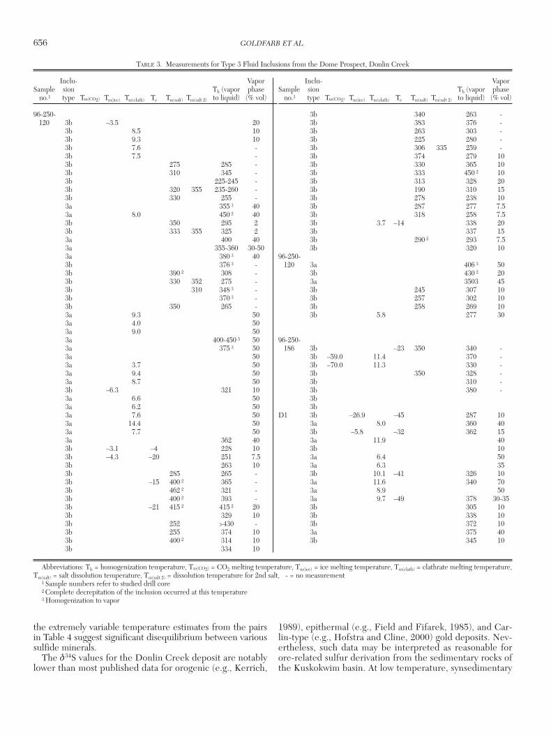
Sulfur
Sulfur isotope ratios were determined for about 50 sulfidemineral separates from gold-bearing veins in drill core fromthe different prospects (Table 4). All sulfur is relatively de-pleted in 34S, with δ34S values mainly ranging between –27.2and –7.3 per mil (Fig. 10). Most values are between about –16and –8 per mil for all prospects, including Dome. However,there is a smaller group with even more depleted sulfur val-ues, which includes three samples of the paragenetically latestibnite from prospects in the southern part of the DonlinCreek deposit. Although petrographic observations suggestthat sphalerite and much of the pyrite are essentially coeval,
DONLIN CREEK Au DEPOSIT, SOUTHWESTERN ALASKA 655
0361-0128/98/000/000-00 $6.00 655
T total (°C)h
6 7 8 9 10 11 12 130
2
4
6
Freq
uenc
y
8
10
12
14
16
18
LewisDome Queen South Lewis
0
2
4
6
8
10
12
14
16
150 200 250 300 350 400 450 500
Freq
uenc
y
(A)
(B)T clathrate (°C)m
FIG. 9. Summary of microthermometric data for (A) clathrate melting and(B) total homogenization from types 1 and 3 fluid inclusions from the Queen,South Lewis, Lewis, and Dome prospects, Donlin Creek gold deposit.
δ S ( / )34 0 00
0
2
4
6
8
10
12
14
Freq
uenc
y
-30 -25 -20 -15 -10 -5 0 5
aspy
py/aspycpwr
stib
sph
realgar
py/cpy
py
FIG. 10. Sulfur isotope data for sulfide minerals separated from mineral-ized zones at the Donlin Creek gold deposits and for samples of the country-rock flysch. Measurements were made on arsenopyrite (aspy), pyrite (py),mixed pyrite and chalcopyrite (py/cpy), realgar, sphalerite (sph), stibnite(stib), chalcopyrite (cp), mixed pyrite and arsenopyrite (py/aspy), and whole-rock samples (wr).
the extremely variable temperature estimates from the pairsin Table 4 suggest significant disequilibrium between varioussulfide minerals.
The δ34S values for the Donlin Creek deposit are notablylower than most published data for orogenic (e.g., Kerrich,
1989), epithermal (e.g., Field and Fifarek, 1985), and Car-lin-type (e.g., Hofstra and Cline, 2000) gold deposits. Nev-ertheless, such data may be interpreted as reasonable forore-related sulfur derivation from the sedimentary rocks ofthe Kuskokwim basin. At low temperature, synsedimentary
656 GOLDFARB ET AL.
0361-0128/98/000/000-00 $6.00 656
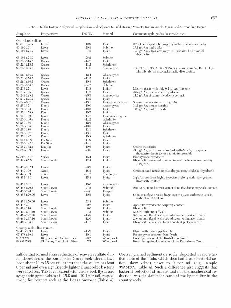
TABLE 3. Measurements for Type 3 Fluid Inclusions from the Dome Prospect, Donlin Creek
Inclu- Vapor Sample sion Th (vapor phase
no.1 type Tm(CO2) Tm(ice) Tm(clath) Te Tm(salt) Tm(salt 2) to liquid) (% vol)
96-250-120 3b –3.5 20
3b 8.5 103b 9.3 103b 7.6 -3b 7.5 -3b 275 285 -3b 310 345 -3b 225-245 -3b 320 355 235-260 -3b 330 255 -3a 355 3 403a 8.0 450 2 403b 350 295 23b 333 355 325 23a 400 403a 355-360 30-503a 380 3 403b 376 3 -3b 390 2 308 -3b 330 352 275 -3b 310 348 3 -3b 370 3 -3b 350 265 -3a 9.3 503a 4.0 503a 9.0 503a 400-450 3 503a 375 3 503a 503a 3.7 503a 9.4 503a 8.7 503b –6.3 321 103a 6.6 503a 6.2 503a 7.6 503a 14.4 503a 7.7 503a 362 403b –3.1 –4 228 103b –4.3 –20 251 7.53b 263 103b 285 265 -3b –15 400 2 365 -3b 462 2 321 -3b 400 2 393 -3b –21 415 2 415 2 203b 329 103b 252 >430 -3b 255 374 103b 400 2 314 103b 334 10
3b 340 263 -3b 383 376 -3b 263 303 -3b 225 280 -3b 306 335 259 -3b 374 279 103b 330 365 103b 333 450 2 103b 313 328 203b 190 310 153b 278 238 103b 287 277 7.53b 318 258 7.53b 3.7 –14 338 203b 337 153b 290 2 293 7.53b 320 10
96-250-120 3a 406 3 50
3b 430 2 203a 3503 453b 245 307 103b 257 302 103b 258 269 103b 5.8 277 30
96-250-186 3b –23 350 340 -
3b –59.0 11.4 370 -3b –70.0 11.3 330 -3b 350 328 -3b 310 -3b 380 -3b3b
D1 3b –26.9 –45 287 103a 8.0 360 403b –5.8 –32 362 153a 11.9 403b 103a 6.4 503a 6.3 353b 10.1 –41 326 103a 11.6 340 703a 8.9 503a 9.7 –49 378 30-353b 305 103b 338 103b 372 103a 375 403b 345 10
Inclu- Vapor Sample sion Th (vapor phase
no.1 type Tm(CO2) Tm(ice) Tm(clath) Te Tm(salt) Tm(salt 2) to liquid) (% vol)
Abbreviations: Th = homogenization temperature, Tm(CO2) = CO2 melting temperature, Tm(ice) = ice melting temperature, Tm(clath) = clathrate melting temperature,Tm(salt) = salt dissolution temperature, Tm(salt 2) = dissolution temperature for 2nd salt, - = no measurement
1 Sample numbers refer to studied drill core2 Complete decrepitation of the inclusion occurred at this temperature3 Homogenization to vapor
sulfide that formed from reduction of seawater sulfate dur-ing deposition of the Kuskokwim Group rocks should havebeen about 20 to 25 per mil lighter than the sulfate or about0 per mil and even significantly lighter if anaerobic bacteriawere involved. This is consistent with whole-rock flysch andsyngenetic pyrite values of –15.9 and –10.1 per mil, respec-tively, for country rock at the Lewis prospect (Table 4).
Coarser grained sedimentary rocks, deposited in more ac-tive parts of the basin, which thus had lesser bacterial ac-tion, show values closer to 0 per mil (e.g., sample98AM269, Table 4). Such a difference also suggests thatbacterial reduction of sulfate, and not thermochemical re-duction, was the dominant cause of the light sulfur in thecountry rocks.
DONLIN CREEK Au DEPOSIT, SOUTHWESTERN ALASKA 657
0361-0128/98/000/000-00 $6.00 657
TABLE 4. Sulfur Isotope Analyses of Samples from and Adjacent to Gold-Bearing Veinlets, Donlin Creek Deposit and Surrounding Region
Sample no. Prospect/area δ34S (‰) Mineral Comments (gold grades, host rocks, etc.)
Ore-related sulfides96-37-trench Lewis –10.9 Pyrite 0.2 g/t Au; rhyodacite porphyry with carbonaceous blebs 96-195-251 Lewis –26.9 Stibnite 17.1 g/t Au; mafic dike96-195-274.9 Lewis –7.8 Pyrite 10.3 g/t Au; >15% arsenopyrite + stibnite; fine-grained
rhyodacite96-195-274.9 Lewis –26.2 Stibnite96-220-215.5 Queen –14.7 Pyrite96-220-215.5 Queen –11.2 Sphalerite96-220-256.2 Queen –11.6 Arsenopyrite 135 g/t Au, 4.9% As, 3.6 % Zn; also anomalous Ag, Bi, Cu, Hg,
Mn, Pb, Sb, W; rhyodacite-mafic dike contact96-220-256.2 Queen –12.4 Chalcopyrite96-220-256.2 Queen –11.3 Pyrite96-220-256.2 Queen –10.8 Sphalerite96-220-256.2 Queen –24.2 Stibnite96-233-271 Lewis –11.8 Pyrite Massive pyrite with only 0.2 g/t Au; siltstone96-247-186.8 Queen –14.2 Pyrite 2.37 g/t Au; fine-grained rhyodacite96-247-225.2 Queen –20.5 Arsenopyrite 14.5 g/t Au; siltstone-rhyodacite contact96-247-225.2 Queen –13.5 Pyrite96-247-307.5 Queen –18.1 Pyrite/arsenopyrite Sheared mafic dike with 10 g/t Au96-250-82 Dome –10.0 Arsenopyrite 1.15 g/t Au; biotite hornfels96-250-120 Dome –10.0 Pyrite 1.36 g/t Au; biotite hornfels96-250-159.8 Dome –10.7 Pyrite96-250-160.8 Dome –15.7 Pyrite/chalcopyrite96-250-160.8 Dome –11.2 Sphalerite96-250-186 Dome –12.6 Chalcopyrite96-250-186 Dome –10.5 Pyrite96-250-186 Dome –11.1 Sphalerite96-250-187 Dome –13.1 Pyrite96-250-187 Dome –10.8 Sphalerite96-254-35.8 Far Side –11.9 Pyrite96-255-122.5 Far Side –14.1 Pyrite97-387-382.5 Duqum –10.6 Pyrite Quartz monzonite97-392-189.3 Dome –9.8 Pyrite 24.5 g/t Au, with anomalous As-Cu-Bi-Mo-W; fine-grained
rhyodacite that is altered to biotite hornfels97-398-157.3 Vortex –16.4 Pyrite Fine-grained rhyodacite97-448-65.5 South Lewis –12.4 Pyrite Rhyodacite; chalopyrite, covellite, and chalcocite are present;
1.48 g/t Au97-478-262.4 Lewis –9.9 Pyrite98-449-199 Acma –18.8 Pyrite Orpiment and native arsenic also present; veinlet in rhyodacite98-449-199 Acma –21.2 Arsenopyrite98-453-36.1 Lewis –15.8 Pyrite 1 g/t Au; veinlet is highly brecciated; along shale–fine-grained
rhyodacite contact98-453-36.1 Lewis –10.0 Arsenopyrite98-455-220.5 South Lewis –27.2 Stibnite 9.57 g/t Au in realgar-rich veinlet along rhyodacite-graywacke contact98-455-220.5 South Lewis –24.6 Realgar98-456-270.06 Lewis –10.5 Pyrite Stibnite-realgar breccia fragments in quartz-carbonate vein in
mafic dike; 2.3 g/t Au98-456-270.06 Lewis –23.8 Stibnite98-478-32 Lewis –20.2 Pyrite Aphanitic-rhyodactite porphyry contact98-489-210 South Lewis –9.0 Pyrite Rhyodacite98-489-297.26 South Lewis –7.3 Stibnite Massive stibnite in flysch98-489-297.26 South Lewis –15.8 Pyrite 0–2 cm into flysch wall rock adjacent to massive stibnite98-489-297.26 South Lewis –12.0 Pyrite 2–6 cm into flysch wall rock adjacent to massive stibnite98-490-198.7 South Lewis –11.7 Pyrite Rhyodacite; veinlet contains abundant pink carbonate
Country-rock sulfur sources97-478-259.1 Lewis –15.9 Pyrite Flysch with preore pyrite clots97-478-259.1 Lewis –10.1 Pyrite Preore pyrite separate from flysch98AM269 Ridge east of Donlin Creek –0.2 Whole rock Fresh graywacke of the Kuskokwim Group98AM278B Cliff along Kuskokwim River –7.5 Whole rock Fresh fine-grained sandstone of the Kuskokwim Group
The H2S produced by decomposition of synsedimentarypyrite will essentially have the same δ34S composition as theoriginal pyrite (e.g., Ohmoto and Rye, 1979). Therefore, sul-fur in syngenetic pyrite and, to a lesser degree, in organicmatter within the fine-grained material of the Kuskokwimbasin is the most likely source for the sulfur in the DonlinCreek deposit. It remains uncertain how that sulfur becamepart of the hydrothermal system, but obvious scenarios mostlikely relate to a metamorphic and crustal melting episode trig-gered by rising mantle melts into the base of the basin (seebelow discussion on radiogenic isotope data). One possibility isthat the sulfur was released directly into the fluid via de-volatilization during metamorphism of rocks that are still atdepth in the basin. Alternatively, during melting of flysch alsodeeper within the basin, sulfur may have entered the ca. 70 Mamelts and then was exsolved later in the magmatic history.Magmatic sulfur has traditionally been accepted to be 0 ± 5 permil (e.g., Ohmoto and Rye, 1979); however, it is now recog-nized that when a magma contains a significant crustal meltcomponent, magmatic δ34S values can approximate those of themelted crust (e.g., as low as –20‰ in Ohmoto and Goldhaber,1997). In summary, either metamorphic or magmatic processesare both compatible with the depleted sulfur isotopes.
The reason for the group of very depleted sulfur measure-ments (i.e., –18 to –27‰) is also unclear. Our preferred expla-nation is that the sulfur data reflect two distinct hydrothermalepisodes. The earlier episode, which included deposition ofmost of the auriferous arsenopyrite and the pyrite, was char-acterized by sulfur contribution from a relatively less de-pleted sedimentary rock source. The more negative δ34Svalues characterize a later episode of sulfide deposition, in-cluding formation of realgar, orpiment, and most of the stib-nite, with the associated fluid containing sulfur that was orig-inally sourced in a distinctively more 34S depleted part of thebasin. The samples defining the more depleted populationwere all collected from the Queen prospect and areas to thesouth. This could reflect the fact that the later hydrothermalfluid flow event was more focused into this part of the Don-lin Creek deposit. However, minor stibnite reported fromdrill cores at the Dome and Quartz prospects to the north wasnot sampled for the sulfur study, and it is thus not clear as towhether the second event was at least locally present in thenorthern part of the deposit.
Alternative explanations for the broad range in δ34S values,such as variations in temperature, redox, or fluid immiscibil-ity, are less likely. As indicated by the relationships in Ohmotoand Goldhaber (1997), a minor temperature and/or redoxchange within the reduced hydrothermal system at DonlinCreek, or H2O-CO2 immiscibility for a reduced hydrothermalsystem, would not have had a major effect on the sulfur iso-tope ratios.
Oxygen and hydrogen
The δ18O data for gold- and sulfide mineral-bearing quartzare also spread over a relatively broad range between about11 and 25 per mil (Table 5). No systematic relationships areevident between gold grade or sulfide mineralogy and δ18O.However, the quartz vein samples from the Dome prospectare, as a whole, 18O depleted when compared to the prospectsfarther south at the Donlin Creek deposit. Measured δ18O
values for Dome samples never exceed 17.4 per mil, whereasmore than half the samples from Queen and Lewis have val-ues between 20 and 25 per mil.
The broad range of δ18O values at Donlin Creek is iden-tical to that characterizing epizonal mercury-antimony min-eralization throughout the Kuskokwim basin (e.g., Goldfarbet al., 1990). These δ18O values are generally higher thanthose measured for quartz from most volcanic rock-hosted
658 GOLDFARB ET AL.
0361-0128/98/000/000-00 $6.00 658
TABLE 5. Oxygen and Hydrogen Isotope Analyses of Hydrothermal Minerals from and Country Rocks to
Gold-Bearing Veinlets, Donlin Creek Deposit
Sample no. Prospect δ180 δD Comments
Gold-bearing veinlets (δ18Oqtz, δDfuchsite)96-37-trench Lewis 14.696-195-251 Lewis 24.796-195-274.9 Lewis 24.696-220-215.5 Queen 20.596-220-256.2 Queen 22.396-247-186.8 Queen 16.896-247-225.2 Queen 14.896-247-307.5 Queen 23.396-250-120 Dome 16.296-250-159.8 Dome 14.896-250-160.8 Dome 11.296-250-186 Dome 17.496-250-187 Dome 16.996-250-188 Dome 15.996-254-35.8 Far Side 14.396-255-122.5 Far Side 14.896-255-124.1 Far Side 19.298-456-270.06 Lewis –123 Fuchsite in quartz in mafic
dike
Whole-rock samples95-175-129.8 Vortex 15.3 Rhyodacite96-250-129 Dome 14.2 Weakly altered quartz-feldspar
porphyry96-250-131 Dome 14.5 Altered quartz-feldspar
porphyry96-254-33.5 Dome 15.1 Unaltered rhyodacite96-255-114 Dome 11.1 Rhyodacite97-363-64 Dome 14.0 Rhyolite97-385-239 Quartz 11.8 Moderately altered97-388-221.8 Duqum 11.1 Porphyry97-398-157.3 ACMA 16.8 Porphyritic rhyodacite97-437-266 Nuno 13.7 Rhyodacite98-387-382.5 Duqum 11.9 Quartz monzonite98-478-32 Lewis 18.7 Fine-grained rhyodacite
porphyry98-478-90 Lewis 15.4 Porphyritic rhyodacite98-489-210 South Lewis 15.0 Altered rhyodacite99AM503 Southwest 17.4 Barren porphyry 13 km
of Lewis southwest of LewisDT-99-265 Dome 15.0 Porphyry from trench
Mineral serparates from igneous country rock95-175-129.8 Vortex 14.3 Quartz from rhyodacite95-175-129.8 Vortex 2.9 Potasium feldspar from
rhyodacite97-387-382.5 Duqum 14.6 –117 Quartz and biotite from
quartz monzonite97-417-133 Rochelieu –92 Fuchsite from altered mafic
dike98-478-90 Lewis –81 Chlorite from rhyodacite98-490-198.7 South Lewis 14.2 Quartz from rhyodacite

epithermal gold deposits (e.g., Field and Fifarek, 1985). Incontrast, the range in δ18O for quartz in Carlin-type depositsis between about 0 and 25 per mil, which does overlap theDonlin Creek range, but also extends to much lower values.The data for Carlin ores are interpreted to be products of themixing between meteoric water and fluids from isotopicallyheavier sources (e.g., magmatic or metamorphic and ex-changed meteoric; Hofstra and Cline, 2000).
The fluid inclusion data indicate a wide variation in de-positional temperatures over the life of the Donlin Creekore system. A spread of 8 per mil in the measured δ18O datawould be consistent with quartz precipitation from a singleoxygen reservoir over a temperature range of 200° to400°C. In addition, fluid interaction with rocks of theKuskokwim Group, which has average δ18O values of 18 to20 per mil (Gray et al., 1997), might also explain some ofthe higher values. We suggest that the δ18O data from Don-lin Creek are best explained by a combination of both vari-ations in temperature and variable water-rock interaction.A major influx of an unexchanged, isotopically light mete-oric water into the ore-forming system is unlikely because,unlike Carlin-type systems, no calculated δ18O fluid valuesfor vein quartz from any of the Donlin Creek prospects ap-proach the meteoric water line (Fig. 11). However, oxygendata for the vein quartz do not preclude the contribution offluids of magmatic, metamorphic, or highly exchanged me-teoric origin.
A group of relatively fresh granitoid samples was collectedfrom drill cores to determine δ18O for the least altered intrusions
(Table 5). Although some of these samples may have beenslightly altered, the whole-rock data cluster with δ18O valuesbetween about 11 and 15 per mil. Such data are consistentwith a predominant flyschoid source for the granitic rocksand the range is typical of, to even slightly heavier than,most reported S-type melts (e.g., O’Neil et al., 1977; Taylorand Sheppard, 1986). Quartz separates from some of thesesamples also fall within the same S-type intrusion range.However, a single K-feldspar separate from these granitoidshas a δ18O value of 2.9 per mil and provides compelling evi-dence that, at some time, unexchanged meteoric fluids werepresent within the Donlin Creek ore zones. The fact that suchlow values are not observed for any of the quartz veins, norfor the above whole-rock samples, suggests that this was aminor and/or low-temperature event during which exchangeonly took place with the feldspars.
Calculation of precise δ18O fluid values (Fig. 11) is difficult,in large part due to the wide variation in temperatures ob-tained from the fluid inclusion studies. Using the quartz-water fractionation curve of Matsuhisa et al. (1979), ore fluidswould be 4 per mil lower than measured quartz values at400°C and 12 per mil lower at 200°C. Considering that thehigher temperature fluid inclusion homogenization measure-ments were associated with the Dome prospect, we estimatethat most fluid δ18O values were consistently between 7 and12 per mil over the entire deposit (assuming 400°C at theDome prospect and 300°C for veins elsewhere at the deposit).
The δ18O values measured by Szumigala et al. (2000) onnine sericite separates from the various prospects at the
DONLIN CREEK Au DEPOSIT, SOUTHWESTERN ALASKA 659
0361-0128/98/000/000-00 $6.00 659
Primary magmatic H O2
Calculated Donlin Creekhydrothermal fluids
Most orogenicgold deposits
0.01
Nevadasediment-hosted
gold depositsMete
oric w
ater li
ne
Meteoric watercomposition forsouthwestern Alaska
Water:rock ratios
Explanation
0.1
0.01
Nevadaepithermal deposits
0
-50
-100
-150 110
1
Devolatilization oforganic matter in sediments
-200-20
Southwestern AlaskaHg-Sb deposits
0 -5-10 -15 15105 20
0.1
X
1
MetamorphicO2H
D (p
er m
il)
O (per mil)18
X
FIG. 11. Plot of δD vs. δ18O for ore fluids from the Donlin Creek gold deposit, SW Alaska. Calculated fluid evolutionpaths at 200°C (black circles) and 300°C (open circles), which are the estimated temperatures for formation of the stibnite-and arsenopyrite-bearing veins in the gold resource area, show that extremely low water to rock ratios would be required ifmeteoric water was a major component in the ore fluids. (Calculations assume an initial δ18O rock value of 16‰ and δD rockvalue of –60‰.) A crustal source is thus required for the bulk of the ore fluid, and magmatic, metamorphic and/or organicreservoirs are all permissive (see text for details). Magmatic, metamorphic, and organic (e.g., devolatilization of organic mat-ter in sediments) water fields after Sheppard (1986); fields for Nevada epithermal and Carlin deposits after Field and Fifarek(1985); and field for SW Alaska deposits after Gray et al. (1997).
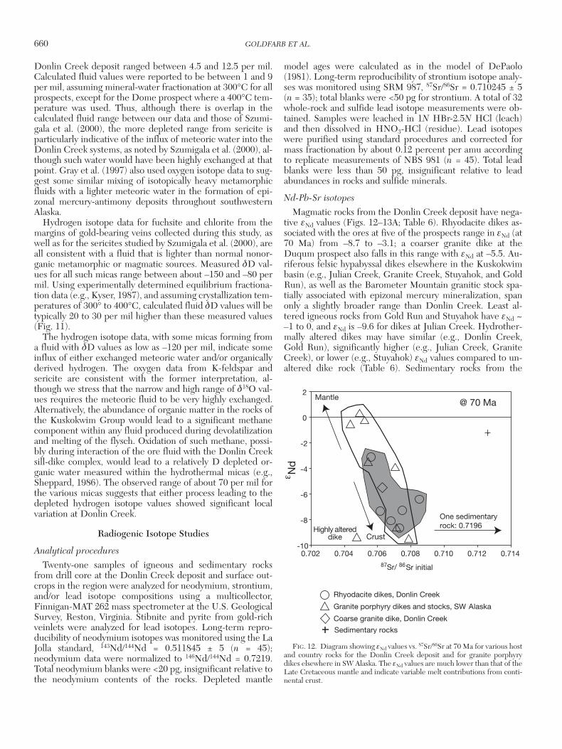
Donlin Creek deposit ranged between 4.5 and 12.5 per mil.Calculated fluid values were reported to be between 1 and 9per mil, assuming mineral-water fractionation at 300°C for allprospects, except for the Dome prospect where a 400°C tem-perature was used. Thus, although there is overlap in thecalculated fluid range between our data and those of Szumi-gala et al. (2000), the more depleted range from sericite isparticularly indicative of the influx of meteoric water into theDonlin Creek systems, as noted by Szumigala et al. (2000), al-though such water would have been highly exchanged at thatpoint. Gray et al. (1997) also used oxygen isotope data to sug-gest some similar mixing of isotopically heavy metamorphicfluids with a lighter meteoric water in the formation of epi-zonal mercury-antimony deposits throughout southwesternAlaska.
Hydrogen isotope data for fuchsite and chlorite from themargins of gold-bearing veins collected during this study, aswell as for the sericites studied by Szumigala et al. (2000), areall consistent with a fluid that is lighter than normal nonor-ganic metamorphic or magmatic sources. Measured δD val-ues for all such micas range between about –150 and –80 permil. Using experimentally determined equilibrium fractiona-tion data (e.g., Kyser, 1987), and assuming crystallization tem-peratures of 300° to 400°C, calculated fluid δD values will betypically 20 to 30 per mil higher than these measured values(Fig. 11).
The hydrogen isotope data, with some micas forming froma fluid with δD values as low as –120 per mil, indicate someinflux of either exchanged meteoric water and/or organicallyderived hydrogen. The oxygen data from K-feldspar andsericite are consistent with the former interpretation, al-though we stress that the narrow and high range of δ18O val-ues requires the meteoric fluid to be very highly exchanged.Alternatively, the abundance of organic matter in the rocks ofthe Kuskokwim Group would lead to a significant methanecomponent within any fluid produced during devolatilizationand melting of the flysch. Oxidation of such methane, possi-bly during interaction of the ore fluid with the Donlin Creeksill-dike complex, would lead to a relatively D depleted or-ganic water measured within the hydrothermal micas (e.g.,Sheppard, 1986). The observed range of about 70 per mil forthe various micas suggests that either process leading to thedepleted hydrogen isotope values showed significant localvariation at Donlin Creek.
Radiogenic Isotope Studies
Analytical procedures
Twenty-one samples of igneous and sedimentary rocksfrom drill core at the Donlin Creek deposit and surface out-crops in the region were analyzed for neodymium, strontium,and/or lead isotope compositions using a multicollector,Finnigan-MAT 262 mass spectrometer at the U.S. GeologicalSurvey, Reston, Virginia. Stibnite and pyrite from gold-richveinlets were analyzed for lead isotopes. Long-term repro-ducibility of neodymium isotopes was monitored using the LaJolla standard, 143Nd/144Nd = 0.511845 ± 5 (n = 45);neodymium data were normalized to 146Nd/144Nd = 0.7219.Total neodymium blanks were <20 pg, insignificant relative tothe neodymium contents of the rocks. Depleted mantle
model ages were calculated as in the model of DePaolo(1981). Long-term reproducibility of strontium isotope analy-ses was monitored using SRM 987, 87Sr/86Sr = 0.710245 ± 5(n = 35); total blanks were <50 pg for strontium. A total of 32whole-rock and sulfide lead isotope measurements were ob-tained. Samples were leached in 1N HBr-2.5N HCl (leach)and then dissolved in HNO3-HCl (residue). Lead isotopeswere purified using standard procedures and corrected formass fractionation by about 0.12 percent per amu accordingto replicate measurements of NBS 981 (n = 45). Total leadblanks were less than 50 pg, insignificant relative to leadabundances in rocks and sulfide minerals.
Nd-Pb-Sr isotopes
Magmatic rocks from the Donlin Creek deposit have nega-tive εNd values (Figs. 12–13A; Table 6). Rhyodacite dikes as-sociated with the ores at five of the prospects range in εNd (at70 Ma) from –8.7 to –3.1; a coarser granite dike at theDuqum prospect also falls in this range with εNd at –5.5. Au-riferous felsic hypabyssal dikes elsewhere in the Kuskokwimbasin (e.g., Julian Creek, Granite Creek, Stuyahok, and GoldRun), as well as the Barometer Mountain granitic stock spa-tially associated with epizonal mercury mineralization, spanonly a slightly broader range than Donlin Creek. Least al-tered igneous rocks from Gold Run and Stuyahok have εNd ~–1 to 0, and εNd is –9.6 for dikes at Julian Creek. Hydrother-mally altered dikes may have similar (e.g., Donlin Creek,Gold Run), significantly higher (e.g., Julian Creek, GraniteCreek), or lower (e.g., Stuyahok) εNd values compared to un-altered dike rock (Table 6). Sedimentary rocks from the
660 GOLDFARB ET AL.
0361-0128/98/000/000-00 $6.00 660
0.708 0.710 0.712 0.714-10
Rhyodacite dikes, Donlin Creek
Granite porphyry dikes and stocks, SW Alaska
Coarse granite dike, Donlin Creek
CrustHighly altered
dike
-6
-2
0
2Mantle
@ 70 Ma
Nd
0.702 0.704 0.706
-8
-4
Sedimentary rocks
One sedimentaryrock: 0.7196
Sr initial87 Sr/ 86
FIG. 12. Diagram showing εNd values vs. 87Sr/86Sr at 70 Ma for various hostand country rocks for the Donlin Creek deposit and for granite porphyrydikes elsewhere in SW Alaska. The εNd values are much lower than that of theLate Cretaceous mantle and indicate variable melt contributions from conti-nental crust.
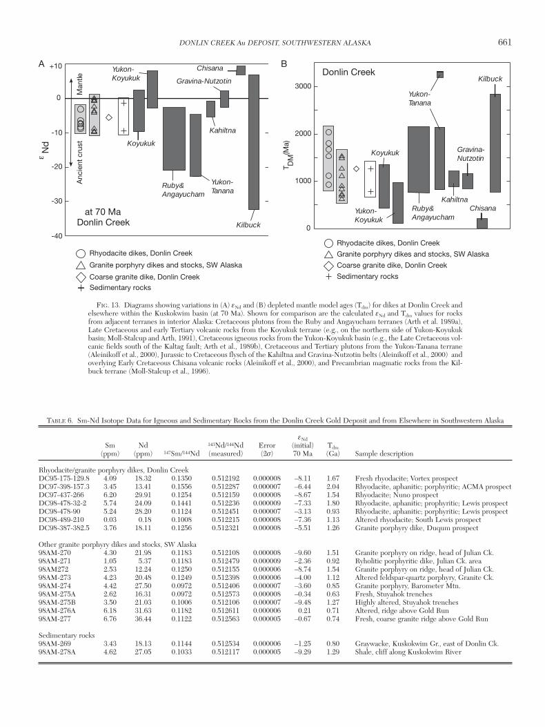
DONLIN CREEK Au DEPOSIT, SOUTHWESTERN ALASKA 661
0361-0128/98/000/000-00 $6.00 661
Koyukuk
Ruby &Angayucham
Yukon-Koyukuk
Yukon-Tanana
Kahiltna
Gravina-Nutzotin
Chisana
KilbuckDonlin Creekat 70 Ma
Man
tleA
ncie
nt c
rust
Nd
-40
-30
-20
-10
0
+10
Rhyodacite dikes, Donlin Creek
Granite porphyry dikes and stocks, SW Alaska
Coarse granite dike, Donlin CreekSedimentary rocks
Rhyodacite dikes, Donlin Creek
Granite porphyry dikes and stocks, SW Alaska
Coarse granite dike, Donlin Creek
Sedimentary rocks
Donlin Creek
0
1000
2000
3000
T DM
(Ma)
Koyukuk
Ruby &Angayucham
Yukon-Koyukuk
Yukon-Tanana
Kahiltna
Gravina-Nutzotin
Chisana
Kilbuck
FIG. 13. Diagrams showing variations in (A) εNd and (B) depleted mantle model ages (Tdm) for dikes at Donlin Creek andelsewhere within the Kuskokwim basin (at 70 Ma). Shown for comparison are the calculated εNd and Tdm values for rocksfrom adjacent terranes in interior Alaska: Cretaceous plutons from the Ruby and Angayucham terranes (Arth et al. 1989a),Late Cretaceous and early Tertiary volcanic rocks from the Koyukuk terrane (e.g., on the northern side of Yukon-Koyukukbasin; Moll-Stalcup and Arth, 1991), Cretaceous igneous rocks from the Yukon-Koyukuk basin (e.g., the Late Cretaceous vol-canic fields south of the Kaltag fault; Arth et al., 1989b), Cretaceous and Tertiary plutons from the Yukon-Tanana terrane(Aleinikoff et al., 2000), Jurassic to Cretaceous flysch of the Kahiltna and Gravina-Nutzotin belts (Aleinikoff et al., 2000) andoverlying Early Cretaceous Chisana volcanic rocks (Aleinikoff et al., 2000), and Precambrian magmatic rocks from the Kil-buck terrane (Moll-Stalcup et al., 1996).
A B
TABLE 6. Sm-Nd Isotope Data for Igneous and Sedimentary Rocks from the Donlin Creek Gold Deposit and from Elsewhere in Southwestern Alaska
εNdSm Nd 143Nd/144Nd Error (initial) Tdm
(ppm) (ppm) 147Sm/144Nd (measured) (2σ) 70 Ma (Ga) Sample description
Rhyodacite/granite porphyry dikes, Donlin CreekDC95-175-129.8 4.09 18.32 0.1350 0.512192 0.000008 –8.11 1.67 Fresh rhyodacite; Vortex prospectDC97-398-157.3 3.45 13.41 0.1556 0.512287 0.000007 –6.44 2.04 Rhyodacite, aphanitic; porphyritic; ACMA prospectDC97-437-266 6.20 29.91 0.1254 0.512159 0.000008 –8.67 1.54 Rhyodacite; Nuno prospectDC98-478-32-2 5.74 24.09 0.1441 0.512236 0.000009 –7.33 1.80 Rhyodacite, aphanitic; prophyritic; Lewis prospectDC98-478-90 5.24 28.20 0.1124 0.512451 0.000007 –3.13 0.93 Rhyodacite, aphanitic; porphyritic; Lewis prospectDC98-489-210 0.03 0.18 0.1008 0.512215 0.000008 –7.36 1.13 Altered rhyodacite; South Lewis prospectDC98-387-382.5 3.76 18.11 0.1256 0.512321 0.000008 –5.51 1.26 Granite porphyry dike, Duqum prospect
Other granite porphyry dikes and stocks, SW Alaska98AM-270 4.30 21.98 0.1183 0.512108 0.000008 –9.60 1.51 Granite porphyry on ridge, head of Julian Ck.98AM-271 1.05 5.37 0.1183 0.512479 0.000009 –2.36 0.92 Ryholitic porphyritic dike, Julian Ck. area98AM272 2.53 12.24 0.1250 0.512155 0.000006 –8.74 1.54 Granite porphyry on ridge, head of Julian Ck.98AM-273 4.23 20.48 0.1249 0.512398 0.000006 –4.00 1.12 Altered feldspar-quartz porphyry, Granite Ck.98AM-274 4.42 27.50 0.0972 0.512406 0.000007 –3.60 0.85 Granite porphyry, Barometer Mtn.98AM-275A 2.62 16.31 0.0972 0.512573 0.000008 –0.34 0.63 Fresh, Stuyahok trenches98AM-275B 3.50 21.03 0.1006 0.512106 0.000007 –9.48 1.27 Highly altered, Stuyahok trenches98AM-276A 6.18 31.63 0.1182 0.512611 0.000006 0.21 0.71 Altered, ridge above Gold Run98AM-277 6.76 36.44 0.1122 0.512563 0.000005 –0.67 0.74 Fresh, coarse granite ridge above Gold Run
Sedimentary rocks98AM-269 3.43 18.13 0.1144 0.512534 0.000006 –1.25 0.80 Graywacke, Kuskokwim Gr., east of Donlin Ck.98AM-278A 4.62 27.05 0.1033 0.512117 0.000005 –9.29 1.29 Shale, cliff along Kuskokwim River
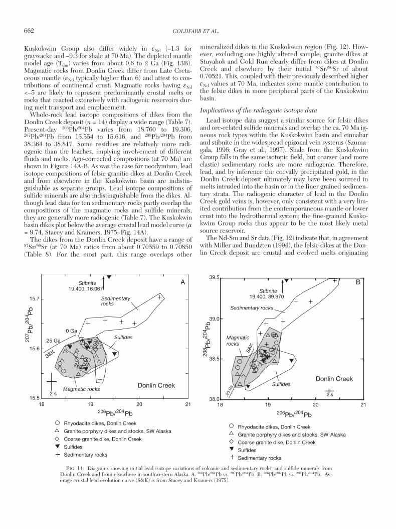
Kuskokwim Group also differ widely in εNd (–1.3 forgraywacke and –9.3 for shale at 70 Ma). The depleted mantlemodel age (Tdm) varies from about 0.6 to 2 Ga (Fig. 13B).Magmatic rocks from Donlin Creek differ from Late Creta-ceous mantle (εNd typically higher than 6) and attest to con-tributions of continental crust. Magmatic rocks having εNd<–5 are likely to represent predominantly crustal melts orrocks that reacted extensively with radiogenic reservoirs dur-ing melt transport and emplacement.
Whole-rock lead isotope compositions of dikes from theDonlin Creek deposit (n = 14) display a wide range (Table 7).Present-day 206Pb/204Pb varies from 18.760 to 19.306,207Pb/204Pb from 15.554 to 15.616, and 208Pb/204Pb from38.364 to 38.817. Some residues are relatively more radi-ogenic than the leaches, implying involvement of differentfluids and melts. Age-corrected compositions (at 70 Ma) areshown in Figure 14A-B. As was the case for neodymium, leadisotope compositions of felsic granitic dikes at Donlin Creekand from elsewhere in the Kuskokwim basin are indistin-guishable as separate groups. Lead isotope compositions ofsulfide minerals are also indistinguishable from the dikes. Al-though lead data for ten sedimentary rocks partly overlap thecompositions of the magmatic rocks and sulfide minerals,they are generally more radiogenic (Table 7). The Kuskokwinbasin dikes plot below the average crustal lead model curve (µ= 9.74, Stacey and Kramers, 1975; Fig. 14A).
The dikes from the Donlin Creek deposit have a range of87Sr/86Sr (at 70 Ma) ratios from about 0.70559 to 0.70850(Table 8). For the most part, this range overlaps other
mineralized dikes in the Kuskokwim region (Fig. 12). How-ever, excluding one highly altered sample, granite dikes atStuyahok and Gold Run clearly differ from dikes at DonlinCreek and elsewhere by their initial 87Sr/86Sr of about0.70521. This, coupled with their previously described higherεNd values at 70 Ma, indicates some mantle contribution tothe felsic dikes in more peripheral parts of the Kuskokwimbasin.
Implications of the radiogenic isotope data
Lead isotope data suggest a similar source for felsic dikesand ore-related sulfide minerals and overlap the ca. 70 Ma ig-neous rock types within the Kuskokwim basin and cinnabarand stibnite in the widespread epizonal vein systems (Szuma-gala, 1996; Gray et al., 1997). Shale from the KuskokwimGroup falls in the same isotopic field, but coarser (and moreclastic) sedimentary rocks are more radiogenic. Therefore,lead, and by inference the coevally precipitated gold, in theDonlin Creek deposit ultimately may have been sourced inmelts intruded into the basin or in the finer grained sedimen-tary strata. The radiogenic character of lead in the DonlinCreek gold veins is, however, only consistent with a very lim-ited contribution from the contemporaneous mantle or lowercrust into the hydrothermal system; the fine-grained Kusko-kwim Group rocks thus appear to be the most likely metalsource reservoir.
The Nd-Sm and Sr data (Fig. 12) indicate that, in agreementwith Miller and Bundzten (1994), the felsic dikes at the Don-lin Creek deposit are crustal and evolved melts originating
662 GOLDFARB ET AL.
0361-0128/98/000/000-00 $6.00 662
Rhyodacite dikes, Donlin Creek
Granite porphyry dikes and stocks, SW Alaska
Coarse granite dike, Donlin Creek
Sulfides
Sedimentary rocks
15.5
15.6
15.7
18
S&K
Donlin Creek
0 Ga
.25 Ga
2 s
Sedimentaryrocks
Magmatic rocks
Stibnite19.400, 16.067
Sulfides
19 20 21
Pb/ Pb204206
Pb
/P
b20
420
7
Rhyodacite dikes, Donlin Creek
Granite porphyry dikes and stocks, SW Alaska
Coarse granite dike, Donlin Creek
Sulfides
Sedimentary rocks
19 20
Pb/ Pb204206
38.0
38.5
39.0
39.5
18 21
SulfidesDonlin Creek
.25
Ga
Sedimentary rocks
Magmaticrocks
Stibnite19.400, 39.970
2 s
S&
KPb
/P
b20
420
8
FIG. 14. Diagrams showing initial lead isotope variations of volcanic and sedimentary rocks, and sulfide minerals fromDonlin Creek and from elsewhere in southwestern Alaska. A. 206Pb/204Pb vs. 207Pb/204Pb. B. 206Pb/204Pb vs. 208Pb/204Pb. Av-erage crustal lead evolution curve (S&K) is from Stacey and Kramers (1975).
A B
DONLIN CREEK Au DEPOSIT, SOUTHWESTERN ALASKA 663
0361-0128/98/000/000-00 $6.00 663
TABLE 7. Th-U-Pb Isotope Data for Rocks and Sulfides from the Donlin Creek Gold Deposit and from Elsewhere in Southwestern Alaska
Th U PbSample no. (ppm) (ppm) (ppm) 206Pb/204Pb 207Pb/204Pb 208Pb/204Pb Sample descriptions
Rhyodacite/granite porphyry dike, Donlin CreekDC95-175-129.8 5.78 3.64 36.00 na na na Fresh rhyodacite; Vortex prospectDC97-398-157.3 4.89 4.95 49.91 na na na Rhyodacite, aphanitic; porphyritic; ACMA prospectDC97-437-266 9.78 10.74 12.19 na na na Rhyodacite; Nuno prospectDC98-478-32-2 7.85 4.42 10.51 na na na Rhyodacite, aphanitic; prophyritic; Lewis prospectDC98-478-90 9.17 3.68 20.94 na na na Rhyodacite, aphanitic; prophyritic; Lewis prospectDC98-489-210 na na na na na na Altered rhyodacite; South Lewis prospectDC98-489-210, r na na na 19.166 15.604 38.705 Altered rhyodacite; South Lewis prospectDC98-489-210, l na na na 18.907 15.580 38.486 Altered rhyodacite; South Lewis prospectDC98-387-382.5 7.47 3.11 20.02 na na na Granite porphyry dike, Duqum prospectDC98-387-382.5, r na na na 19.006 15.584 38.544 Granite porphyry dike, Duqum prospectDC98-387-382.5, l na na na 19.222 15.603 38.798 Granite porphyry dike, Duqum prospect
Other granite porphyry dikes and stocks, SW Alaska98AM-270 8.05 5.65 14.18 na na na Granite porphyry on ridge, head of Julian Ck.98AM-271 6.29 3.59 23.06 na na na Ryholitic porphyritic dike, Julian Ck. area98AM-271 r na na na 19.059 15.576 38.537 Ryholitic porphyritic dike, Julian Ck. area98AM-271 l na na na 18.821 15.574 38.411 Ryholitic porphyritic dike, Julian Ck. area98AM272 4.96 3.35 23.73 na na na Granite porphyry on ridge, head of Julian Ck.98AM-273 6.03 3.04 54.61 na na na Altered feldspar-quartz porphyry, Granite Ck.98AM-273, r na na na 19.165 15.587 38.667 Altered feldspar-quartz porphyry, Granite Ck.98AM-273, l na na na 18.760 15.569 38.364 Altered feldspar-quartz porphyry, Granite Ck.98AM-274 8.40 1.99 24.98 na na na Granite porphyry, Barometer Mtn.98AM-274 r na na na 18.881 15.567 38.445 Granite porphyry, Barometer Mtn.98AM-274 l na na na 19.188 15.616 38.488 Granite porphyry, Barometer Mtn.98AM-275A 9.58 3.81 18.72 na na na Fresh, Stuyahok trenches98AM-275A, r na na na 18.874 15.605 38.606 Fresh, Stuyahok trenches98AM-275B 9.88 3.03 202.52 na na na Highly altered, Stuyahok trenches98AM-275B, r na na na 18.876 15.570 38.560 Highly altered, Stuyahok trenches98AM-275B, l na na na 18.850 15.585 38.581 Highly altered, Stuyahok trenches98AM-276A 12.91 5.13 28.74 na na na Altered, ridge above Gold Run98AM-276A, r na na na 19.306 15.581 38.817 Altered, ridge above Gold Run98AM-277 12.17 4.53 38.68 na na na Fresh, coarse granite ridge above Gold Run98AM-277, r na na na 19.046 15.571 38.582 Fresh, coarse granite ridge above Gold Run98AM-277, l na na na 18.848 15.554 38.400 Fresh, coarse granite ridge above Gold Run
Sedimentary rocks98AM-269 4.70 1.92 na na na na Graywacke, Kuskokwim Gr., east of Donlin Ck.98AM-269, r na na na 19.582 15.637 38.966 Graywacke, Kuskokwim Gr., east of Donlin Ck.98AM-269, l na na na 18.966 15.586 38.530 Graywacke, Kuskokwim Gr., east of Donlin Ck.98AM-269, r na na na 20.434 15.694 39.447 Graywacke, Kuskokwim Gr., east of Donlin Ck.98AM-269, l na na na 19.012 15.636 38.694 Graywacke, Kuskokwim Gr., east of Donlin Ck.98AM270B, r na na na 19.352 15.657 38.972 Silty shale, southeast of Julian Ck.98AM270B, l na na na 18.926 15.623 38.595 Silty shale, southeast of Julian Ck.98AM-278A 8.11 3.80 22.32 na na na Shale, cliff along Kuskokwim River98AM278A , r na na na 19.314 15.539 38.794 Shale, cliff along Kuskokwim River98AM278A, l na na na 18.997 15.611 38.565 Shale, cliff along Kuskokwim River98AM278B, r na na na 20.023 15.653 39.263 Sandstone, cliff along Kuskokwim River98AM278B, l na na na 19.161 15.612 38.614 Sandstone, cliff along Kuskokwim River
Sulfide minerals, Donlin Creek deposit97-448-65.5, pyrite, l na na na 19.495 15.589 38.480 Pyrite, (in rhyodacite)97-448-65.5, pyrite, r na na na 18.913 15.559 38.476 Pyrite, (in rhyodacite)98-456-270, stibnite, l na na na 18.934 15.602 38.595 Stibnite, (in mafic dike)98-456-270, stibnite, r na na na 19.400 16.067 39.970 Stibnite, (in mafic dike)DC98489-297.26,
stibnite, l na na na 18.582 15.603 38.164 Stibnite, (in mafic dike)DC98489-297.26,
stibnite, r na na na 18.980 15.612 38.524 Stibnite, (in mafic dike)
Abbreviations: l = leach, na = not analyzed, r = residue
from mature, thickened crust. This may not be the case re-gionally, however, for the entire group of gold-mineralized,felsic porphyry dikes. As noted above, gold-enriched felsicdikes at occurrences such as Stuyahok (this study) andVinasale (Szumigala, 1993) have εNd of ~0 and 87Sr/86Sr of~0.704 to 0.705, consistent with an immature arc sourcecharacterized by a higher proportion of rocks geneticallylinked to the mantle. This notion is further supported by εNddata for felsic dikes and rocks of the volcanic-plutonic com-plexes from the entire Kuskokwim region (Szumigala, 1993),with εNd from –4 and +1. A large mantle contribution into agiven melt does not correlate with gold volume in an igneousrock body; rather, structural traps for postcrystallization min-eralizing fluids may have been the most important featurethat localized the gold mineralization within any specific dikecomplex in the Kuskokwim basin.
The Nd-Pb isotope values of igneous rocks at DonlinCreek, and for roughly age-equivalent Late Cretaceous ig-neous rocks from terranes flanking the Kuskokwim basin,suggest fundamental differences in the deep crust of interiorAlaska. The εNd values range from about 0 to –10 at DonlinCreek and elsewhere in the Kuskokwim basin, higher than forgranitic plutons from the Ruby and Angayucham terranes(Fig. 13A), which are immediately to the north and have εNdmostly lower than –10 (Arth et al., 1989a). Values for Creta-ceous and Tertiary granitic plutons to the northeast in thegold-rich (e.g., Fairbanks district) Yukon-Tanana terrane (alsowith εNd lower than –10), as well as tonalitic and graniticgneisses and amphibolites from the Precambrian Kilbuckterrane to the south (Moll-Stalcup, 1994), can be attributed toancient crustal reservoirs. We thus can eliminate this type ofancient and fractionated crustal reservoir as the source ofthe melts at Donlin Creek. In addition, lead isotope crustal
reservoirs associated with granites in the Ruby, Angayucham,and Yukon-Tanana terranes and farther northwest on theSeward Peninsula are too radiogenic and therefore also in-compatible with igneous rocks at Donlin Creek (Fig. 15). Vol-canic rocks from the Yukon-Koyukuk basin (including theChisana volcanic rocks), also north of the Kuskokwim basin,are linked to the mantle by virtue of their positive εNd values(Moll-Stalcup and Arth, 1991; Aleinikoff et al., 2000). Theirmuch higher εNd, when compared to the Donlin Creek dikes,define what should be the mantlelike signature for Creta-ceous-Tertiary melts in interior Alaska.
Negative εNd values for the Donlin Creek dikes eliminate adirect association with juvenile, mantle-derived rocks andhelps to characterize the type of crustal contribution to mag-matism that was coeval with the gold-forming event. The Tdmvalues at Donlin Creek are substantially older than Creta-ceous (i.e., >500 Ma) and allow for contributions of crust asold as 2 Ga (Fig. 13B), but one that was less fractionated forSm/Nd than the Ruby, Angayuchum, and Yukon-Tananaterranes (Fig. 13A). Lead data also eliminate a major contri-bution from ancient, granulite-type lower crust (no enrich-ment of 208Pb/204Pb relative to 206Pb/204Pb), but the 207Pb/204Pb results allow a minor contribution from the mantle (asunderplated mafic rocks at the base of the crust) in theDonlin Creek area (Fig. 15). Jurassic to Cretaceous Kahiltnaterrane flysch and Gravina-Nutzotin belt flysch (Aleinikoff etal., 2000) overlap the neodymium and lead isotope composi-tions of the Donlin Creek dikes but are significantly morehomogeneous for neodymium. The deep crust in the Donlin
664 GOLDFARB ET AL.
0361-0128/98/000/000-00 $6.00 664
TABLE 8. Rb-Sr Isotope Data for Igneous and Sedimentary Rocks from the Donlin Creek Gold Deposit and from Elsewhere in
Southwestern Alaska (for sample descriptions see Table 6)
Rb Sr 87Sr/86Sr Error Sample no. (ppm) (ppm) Rb/Sr (measured) (2σ)
Rhyodacite/granite porphyry dike, Donlin CreekDC95-175-129.8 127.8 144.3 0.89 0.709275 0.000010DC97-398-157.3 108.0 40.2 2.69 0.716045 0.000012DC97-437-266 129.5 102.0 1.27 0.710893 0.000009DC98-478-32-2 150.2 50.4 2.98 0.715861 0.000010DC98-478-90 116.5 213.4 0.55 0.707125 0.000007DC98-489-210 116.0 214.0 0.54 0.707689 0.000009DC98-387-382.5 84.0 460.1 0.18 0.706784 0.000009
Other granite porphyry dikes and stocks, SW Alaska98AM-270 123.5 96.7 1.28 0.711465 0.00000698AM272 120.9 245.4 0.49 0.708528 0.00000798AM-273 84.8 204.6 0.41 0.708220 0.00000898AM-274 84.9 255.3 0.33 0.706361 0.00000898AM-275A 4.4 70.4 0.06 0.705381 0.00000898AM-275B 82.0 15.3 5.36 0.719791 0.00000998AM-276A 120.6 78.9 1.53 0.709208 0.00000798AM-277 105.9 198.5 0.53 0.705851 0.000006
Sedimentary rocks98AM-269 47.6 94.2 0.51 0.714034 0.00000998AM-278A 109.6 48.8 2.25 0.725903 0.000006
Pb/ Pb204206
Pb
/P
b20
420
7
S&K.25 Ga
Yukon-Tanana
Chisana
Yukon-Koyukuk
Kahiltna-Gravina flysch
Ruby &Angayucham
Seward
Igneous rocks,Donlin Creek
Donlin Creeksedimentary rocks
Man
tleC
rust
15.5
15.6
15.7
15.8
15.9
18 19 20 21
FIG. 15. Plot of initial lead isotope variations of volcanic and plutonicrocks from the Donlin Creek and other felsic dikes in the Kuskokwim basin,using 206Pb/204Pb vs. 207Pb/204Pb. Isotopic fields for igneous and metamorphicrocks from adjacent terranes are shown for comparison: Cretaceous graniticplutons from the Ruby, Angayucham, and Yukon-Koyukuk terranes (Arth etal., 1989a-b), Cretaceous granitic rocks from the Seward terrane (R. Ayuso,unpub. data), Cretaceous and Tertiary granitic plutons from the Yukon-Tanana terrane (Aleinikoff et al., 2000), Jurassic to Cretaceous flysch fromthe Kahiltna and Gravina-Nutzotin belts (Aleinikoff et al., 2000), and Creta-ceous Chisana volcanic rocks (Aleinikoff et al., 2000). Average crustal leadevolution curve (S&K) is from Stacey and Kramers (1975).
Creek area, therefore, more closely resembles the crustunder the Koyukuk terrane, as characterized by neodymiumand lead isotope compositions of Cretaceous plutons (Arth etal., 1989b). Both areas exhibit nearly identical ranges of εNdand greatly overlap in their lead isotope values (especially in207Pb/204Pb), although the Tdm values for Donlin Creek pointto additional contributions from older rocks than in theKoyukuk terrane (<1.5 Ga).
In summary, radiogenic isotope data indicate that (1) leadin the Donlin Creek gold ores, in regional epizonal mercurylodes, and in granitoids throughout the Kuskokwim basin hasa similar source; (2) the felsic dikes at Donlin Creek predom-inantly represent melted, fine-grained sedimentary rocks ofthe Kuskokwim basin; and (3) in contrast to Donlin Creek,many of the other granite porphyry dikes and stocks in thebasin have a significant mantle component. This is consistentwith the model of Bundtzen and Miller (1997) that invokesintrusion of mantle melts to form the volcanic-plutonic com-plexes and to melt lower parts of the Kuskokwim basin. Manyfelsic dikes, including those at Donlin Creek, were at leastpartial products of this crustal melting.
Discussion
Previous classifications of the Donlin Creek gold deposit
Detailed genetic models or a specific classification of theDonlin Creek gold deposit remain problematic. Goldfarb etal. (1990), using data collected from samples of the exposedhistoric Snow Gulch prospect at Donlin Creek and many ofthe regional Hg-Sb deposits, suggested that sulfur and orefluids were derived from sedimentary rocks within the deeperparts of the >10-km-thick Kuskokwim basin. They indicatedthat δ18O values for meteoric water at ca. 70 Ma would beabout –20 per mil and thus water/rock ratios of 0.01 or lesswould be required to obtain estimated fluid δ18O values thatwere some 25 to 30 per mil higher. It is unlikely, however, thatsuch a rock-dominated flow system could have transportedthe many millions of ounces of gold into the Donlin Creek de-posit without much of the immense fluid volume being in-volved in hydration reactions along the required diffuse flowpathway (e.g., Yardley, 1997). Rather, the concentration of>20 Moz Au within the competent dike rocks at the southernpart of the Donlin Creek deposit suggests a high water/rockregime, such that flow was highly focused. It is possible thatthe same poorly understood pathway for the crustal melts atthe deposit also served as the fluid conduit.
Because of the consistently high δ18O values for all theKuskokwim region lode deposits, Goldfarb et al. (1990) inter-preted the low δD from the Red Devil mercury deposit as aproduct of devolatilization, particularly of organic matter andfine-grained sedimentary rocks, driven by a metamorphic ormagmatic heat source (e.g., organic water of Sheppard, 1986).Low-salinity fluid inclusions were quoted as evidence againstthe involvement of basinal connate waters for metal deposi-tion in the studied epithermal Hg-Sb lode systems.
Bundtzen and Miller (1997) suggested that Donlin Creekand other Hg-, Sb-, and Au-bearing lodes of southwesternAlaska were genetically related to the Late Cretaceous-earlyTertiary magmatism. They argued that these lodes possessedfeatures similar to those of the alkalic-rock–related gold
deposits of the Rocky Mountain region (e.g., Kelley and Lud-ington, 2002). Gray et al. (1997), in an additional regionalstudy, considered ore-forming fluids for the Donlin Creekand other deposits to have been derived from a complex mix-ing of metamorphic, connate, evolved meteoric water, andmagmatic sources. They presented oxygen isotope data thatleft little doubt of the involvement of meteoric water at boththe Red Top epithermal mercury deposit (300 km south ofDonlin Creek) and at the nearby Granite Creek gold prospect(Fig. 1), which is geologically similar to the Donlin Creek de-posit. Ebert et al. (2000a) noted that much of the DonlinCreek deposit resembled a low-sulfidation epithermal sys-tem, although the Dome prospect showed features morecharacteristic of an intrusion-related gold deposit (e.g., Langand Baker, 2001). Together, these observations have beenused to further suggest the possibility that boiling of deeperfluids, now preserved in fluid inclusions at the Domeprospect, led to escape of a low-density vapor phase thattransported the bulk of the gold now in the southern part ofthe Donlin Creek deposit (Ebert et al., 2003b). Hart et al(2002) termed Donlin Creek a high-level, epizonal gold de-posit with an uncertain genetic link to magmatism.
Comparison of the Donlin Creek deposit to existing gold deposit models
Significant differences exist between the Donlin Creek de-posit and typical epithermal gold deposits (e.g., Cooke andSimmons, 2000; Hedenquist et al., 2000). Gold-depositingfluids are consistently CO2 poor in epithermal systems, al-though it has been long recognized that below epithermal orezones, CO2 can be present in significant amounts that arethen lost by boiling (Henley, 1985). Nevertheless, microther-mometric observations of gas hydrate and solid CO2 crystal-lization during freezing experiments, indicative of perhaps 3to 7 mol percent gas in the Donlin Creek ore fluids, are rarelyreported in the literature on epithermal deposits. Althoughthere are exceptions, in the deeper parts of many low-sulfida-tion epithermal systems, commonly at maximum depths of300 to 800 m, base metal sulfide minerals are typical andAg/Au exceeds 1.0. At the Donlin Creek deposit, which is es-timated to have formed at 1 to 2 km, Au/Ag ≥1 and there is alack of base metal enrichment, although copper-rich stock-works at the Dome prospect may or may not be related to thegold ores (see below). The Donlin Creek ore fluids are alsodistinctly enriched in 18O compared to epithermal gold de-posits (Fig. 11), although it might be argued that becauseDonlin Creek formed at slightly deeper levels than most ep-ithermal deposits, it was less likely to have undergone signifi-cant mixing with isotopically light meteoric water.
There are also clear differences between the Donlin Creekdeposit and Carlin-type gold deposits as defined by Hofstraand Cline (2000). The latter typically formed at lower tem-peratures (120°–180°C) and from fluids of lower gas content(1–4 mol % CO2). The common late, low-temperature opa-line silica and chalcedony in Carlin deposits are not commonat Donlin Creek. The depths of ore formation are similar,widespread kaolinite is present in both systems, and shallowvein textures appear locally at Donlin Creek, but the broaderrange in δ18O for the Carlin-like ores (Fig. 11) suggests agreater involvement of meteoric water. Gold/silver ratios
DONLIN CREEK Au DEPOSIT, SOUTHWESTERN ALASKA 665
0361-0128/98/000/000-00 $6.00 665
between 3 to 20, anomalous Ba, Te, and W in some ore zones,and gold-bearing pyrite that characterizes the Carlin depositsall are distinct from features observed in the Donlin Creekgold ores. Although sulfidation and silicification are recog-nized in both systems, argillic alteration of silicates is re-stricted to the Carlin deposits.
Geological and geochemical characteristics of the DonlinCreek deposit most closely resemble those associated withboth orogenic and intrusion-related gold deposit types. Fea-tures consistent with the orogenic gold deposit model ofGroves et al. (1998) include an association with placer accu-mulations, an Ag-As-Au-Hg-Sb geochemical signature thatreflects sulfide complexing of metals, low base metal contentof the gold resource, significant CO2 within the ore-formingfluid, Au/Ag of unity or slightly higher, isotopically heavy oxy-gen in the ore fluids, a sericite-carbonate-pyrite alteration as-semblage, and localization of ores in a zone of high structuralcompetency contrast. As with most Phanerozoic orogenicgold deposits (e.g., Goldfarb et al., 2001), the Donlin Creekdeposit formed in sedimentary rocks within an active colli-sional margin late during a period of regional strike-slip tec-tonism. The association of organic material with orogenicgold deposits is also common where ore fluids may be pro-duced by metamorphic devolatilization of sedimentary rocks(e.g., Bierlein and Crowe, 2000). The broad range in esti-mated fluid δD at Donlin Creek (–120 to –50 per mil) is prob-lematic. It could represent variable contributions from mete-oric water, but the lack of notably low δ18Oquartz suggests thatmuch of the variation could record variable fluid input to thehydrothermal system from devolatilization of organic matter(cf. Sheppard, 1986). The low trapping pressures and brittlenature of the ore zones indicate that, if Donlin Creek is clas-sified as an orogenic gold deposit, it would be of the epizonalsubtype (e.g., Gebre-Mariam et al., 1995; Groves et al., 1998;Hart et al., 2002).
Alternatively, ore deposition at temperatures of 275° to300°C and depths of 1 to 2 km supports extremely high geo-thermal gradients in this part of the Kuskokwim basin. Thismight warrant the classification of the Donlin Creek depositas an intrusion-related gold deposit (e.g., Thompson et al.,1999; Lang and Baker 2001), a deposit type whose featuresare difficult to distinguish from those of more widely recog-nized orogenic gold deposits (Sillitoe and Thompson, 1998).If Donlin Creek is indeed an intrusion-related gold deposit,then the causative intrusion remains to be recognized. Onepossibility is that the intrusion is buried beneath the hornfelsKuskokwim Group rocks at the Dome prospect. However,given the anatectic nature of many of the granitoids in south-western Alaska, it might be impossible to tell whether the orefluids evolved during prograde metamorphism of the flysch inthe deforming basin (possibly caused by rising mantle magma)or if they were exsolved from a magma that formed from themelting of the flysch. In such circumstances, where high tem-peratures produce both devolatilization and then melting of asequence of sedimentary rocks, a distinction between intru-sion-related and orogenic gold deposit types is difficult.
Preferred genetic model
The Kuskokwim flysch basin that hosts the Donlin Creekdeposit formed during a ca. 20-m.y.-long interval in the Late
Cretaceous. The continental crust that formed the basementof the basin had only recently been assembled from conti-nental fragments (Farewell and Kilbuck terranes), an islandarc (Togiak terrane), and obducted ocean floor (Innoko ter-rane). The basin formed in the continental back-arc above aroughly north- or northwest-dipping subduction zone alongAlaska’s Pacific margin. Donlin Creek was probably locatedabout 500 km landward of the paleotrench.
The 70 Ma age of the Donlin Creek deposit is noteworthyfor several reasons. First, an exceptionally wide and vigorousarc evolved at this time (Alaska Range and KuskokwimMountains belts of Wallace and Engebretson, 1984). Second,gold and mercury mineralization developed across a widezone in southwestern Alaska (Bundtzen and Miller, 1997).Third, both the Iditarod and Denali fault systems appear tohave undergone dextral displacement at ca. 70 Ma (Miller etal., 2002). Finally, at Donlin Creek and other locations be-tween the regional strike-slip faults, lower order structuresrecord roughly north-south compression at ca. 70 Ma, whichwould seem to be more compatible with sinistral strike-slipon the two master faults (Ebert et al., 2000a). If such a pulseof sinistral motion did take place on the Iditarod fault (as fa-vored by Ebert et al., 2002a), it would have been no morethan a momentary reversal of motion on a long-lived dextralsystem. Alternatively, the complex system of structures atDonlin Creek may reflect the interplay between northwardcoast-parallel terrane transport along the Canadian margin tothe southeast (itself the product of dextral-oblique conver-gence) and roughly orthogonal subduction beneath south-western Alaska (Miller et al., 2002). The possibility exists thatby 70 Ma, southwestern Alaska was being affected by the ap-proach of the Kula-Resurrection (or Kula-Farallon) spreadingridge and its attendant slab window (Bradley et al., 2003).More likely, however, this did not happen until ca. 63 Ma.
Mantle melts formed throughout the Maastrichtian in thewedge above the subducting slab (e.g., Moll-Stalcup, 1994)and below the 30- to 35-km-thick crust (Barnes, 1977). Theupper part of this crust, defined by the Kuskokwim flysch,may have exceeded 10 km in thickness by the end of basinsedimentation at ca. 70 Ma. The mantle melts, which weresignificantly contaminated by the overlying crustal rocksthrough which they passed (Moll-Stalcup, 1994), reached thesurface and near-surface in many parts of the Kuskokwimbasin and also are spatially associated with hornfels in theflysch. More local flysch melts are evidenced by some dikeswarms, such as the ca. 70 Ma swarm that hosts the ore atDonlin Creek.
Isotope and fluid inclusion data are consistent with a num-ber of feasible ca. 70 Ma ore fluid sources within the Kuskok-wim basin (Fig. 16). The relatively competent rocks of thecrustally derived felsic dike swarm provided a favorable struc-tural host for the gold ores, and fluid exsolution from deeperparts of the same crustal melt reservoir is one possible mech-anism for ore formation. An alternative scenario is that thefluids were released from broad-scale devolatilization reac-tions triggered by the rising geotherms above the mantlemelts; these mantle magmas would thus have been responsi-ble for both flysch melts and fluid generation in the deeperparts to the Kuskokwim basin. The extremely depleted δ34Svalues of the ore-related sulfide minerals, however, are
666 GOLDFARB ET AL.
0361-0128/98/000/000-00 $6.00 666
incompatible with magmatic fluids that are derived frommelts with a strong mantle component, which are commonelsewhere throughout the Kuskokwim basin. If the ore fluidswere from a magmatic fluid source, then such a source meltmust have been mainly anatectic in nature. Hydrogen andoxygen isotope data indicate that some meteoric water com-ponent may have mixed with the deeper crustal hydrothermalsystem, but it was of minor significance.
The circulating hydrothermal fluids were focused intobrittle fractures, which were localized in low-order dila-tional zones adjacent to local strike-slip faults (i.e., DonlinCreek fault) in the Kuskokwim basin. The relatively compe-tent, coeval to slightly older (by no more than a few millionyears) felsic dikes at Donlin Creek were the site of the asso-ciated north-south–directed compression during the ongo-ing far-field dextral strike-slip on the more regional faults.
DONLIN CREEK Au DEPOSIT, SOUTHWESTERN ALASKA 667
0361-0128/98/000/000-00 $6.00 667
Contaminated mantle melt
Kuskokwim flysch melt
Kuskokwim Group: Shales and greywackes
Donlin Creek deposit
Hornfels
Prospects
Donlin CreekDeposit Heated
meteoricwater
B
A
Farewell/Yukon -Tanana terranes
Togiakterrane
Kuskokwimbasin
0
35
70
Dep
th, k
m
QtzSL QnR S D
Lithosphericmantle
Asthenosphericmantle
LatestCretaceous to early Tertiary
Kula Plate
Accretedarcs
Earlymagmatic
fluidMagmaticfluid
Metamorphicdevolatilization
Metamorphicdevolatilization
R D
FIG. 16. Genetic model for evolution of the Donlin Creek gold deposit with crustal structure generalized after Moll-Stal-cup and Arth (1989) and Gray et al. (1997). A. Partial mantle melting above the subducting Kula plate led to the emplace-ment of crustally contaminated intrusions and volcanic-plutonic complexes throughout the Kuskokwim basin. In a few loca-tions, and including at the site of the Donlin Creek deposit, small, almost pure flysch melts evolved. B. Gold-transportinghydrothermal fluids were released during devolatilization of flysch deep in the Kuskokwim basin and/or from the flysch meltsthemselves. It is uncertain as to whether minor amounts of surface waters also entered the hydrothermal system. The fluidslocalized the gold-bearing veins in the already crystallized and structurally competent, flysch-melt dike-sill complex at Don-lin Creek (e.g., forming prospects that include South Lewis (SL), Rochilieu (R), Queen (Qn), Snow (S), Quartz (Qtz), Dome(D)). A high-temperature, early magmatic copper-gold vein set at the Dome prospect, which was subsequently overprintedby the main-stage Donlin Creek gold event, is spatially associated with a hornfels zone perhaps indicative of a relatively ex-tensive buried plutonic body.
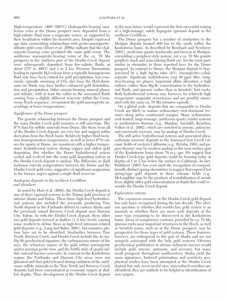
High-temperature (400°–550°C) chalcopyrite-bearing auri-ferous veins at the Dome prospect were deposited from ahigh-salinity fluid near a magmatic source, as supported bytheir localization within the hornfels area. Despite equivocalage data, crosscutting relationships with pyrite-arsenopyrite-stibnite-gold veins (Ebert et al., 2000a) indicate that the chal-copyrite-bearing veins predated the main gold event. Theauriferous arsenopyrite-bearing veins at the ca. 70 Maprospects in the southern part of the Donlin Creek depositwere subsequently deposited from low-salinity fluids, atabout 275° to 300°C and 1 to 2 km. Pressure fluctuationsleading to episodic H2S release from a typically homogeneousfluid may have been critical for gold precipitation; less com-monly, episodic unmixing of CO2 also from the H2O-domi-nant ore fluids may have further enhanced gold destabiliza-tion and precipitation. Other arsenic-bearing mineral phasesand stibnite, with at least the sulfur in the associated fluidscoming from a slightly different reservoir within the Creta-ceous flysch sequence, overprinted the gold-arsenopyrite as-semblage at lower temperatures.
Significance of the Dome prospect
The genetic relationship between the Dome prospect andthe main Donlin Creek gold resource is still uncertain. Theδ34S data for sulfide minerals from Dome, like those from allof the Donlin Creek deposit, are very low and suggest sulfurderivation from the flysch basin. Relatively higher fluid inclu-sion homogenization temperatures, as well as lower δ18O val-ues for quartz at Dome, are consistent with a higher temper-ature hydrothermal system during copper and oldest golddeposition. But whether the Dome hydrothermal systemcooled and evolved into the main gold depositing system atthe Donlin Creek deposit is unclear. The difference in fluidinclusion eutectic temperatures between the Dome and theDonlin Creek gold veins, suggestive of significant magnesiumin the former, argues against a single fluid reservoir.
Analogous deposits in the northern Cordillera and elsewhere
As noted by Hart et al. (2002), the Donlin Creek deposit isone of three epizonal systems in the Tintina gold province ofinterior Alaska and Yukon. These three high-level hydrother-mal systems also included the presently producing TrueNorth deposit in the Fairbanks district in eastern Alaska andthe previously mined Brewery Creek deposit near DawsonCity, Yukon. As with the Donlin Creek deposit, these othertwo gold deposits formed at shallow (1–2 km) levels, causingsome workers to define them as high-level intrusion-relatedgold deposits (e.g., Lang and Baker, 2001), but causative plu-tons have yet to be identified. Similarities between TrueNorth, Brewery Creek, and Donlin Creek include the As-Au-Hg-Sb geochemical signature, the carbonaceous nature of theores, the refractory nature of the gold within arsenopyriteand/or arsenian pyrite rims, and the brittle style of quartz sul-fide mineral fracture networks. In contrast to the Kuskokwimregion, the Fairbanks and Dawson City areas were notglaciated and thus gold released during oxidation of the aurif-erous sulfide minerals in the True North and Brewery Creekdeposits had been concentrated as economic targets at shal-low depths. Thus, development of the Donlin Creek deposit
in the near future would represent the first successful miningof a high-tonnage, solely hypogene epizonal deposit in thenorthern Cordillera.
The Dome prospect has a number of similarities to theShotgun deposit located 400 km to the south within theKuskokwim basin. As described by Rombach and Newberry(2001), auriferous quartz stockworks and breccia at Shotgun,resembling a porphyry-style system, cut a ca. 70 Ma graniteporphyry stock and mineralizing fluids are, for the most part,similar in chemistry to those reported here for the Domeprospect. In contrast to Dome, the Shotgun deposit is char-acterized by a high Ag/Au ratio (4/1), arsenopyrite>>chal-copyrite, significant molybdenum (avg 40 ppm Mo), tung-sten-bearing ore phases, important albite alteration, a highsodium (rather than Mg-K) concentration in the hydrother-mal fluids, and igneous (rather than in hornfels) host rocks.Both hydrothermal systems may, however, be relatively hightemperature magmatic occurrences and are possibly associ-ated with the same ca. 70 Ma intrusive episode.
On a global scale, deposits that are comparable to DonlinCreek are likely in marine sedimentary rock-dominant ter-ranes along active continental margins. Many sedimentaryrock-hosted, large-tonnage, auriferous quartz veinlet systemsin northeastern Russian (e.g., Maiskoe, Sarylakh, Kyuchus;Volkov et al., 2002), which are enriched in arsenic, antimony,and commonly mercury, may be analogs of Donlin Creek.
The still active hydrothermal systems and associated silica-carbonate mercury deposits in the Sonoma-Clear Creek vol-canic fields of western California (e.g., Rytuba, 1993, and pa-pers therein) may be modern analogs to the near-surface partof the Kuskokwim basin about 70 m.y. ago. We suggest thatDonlin Creek-type gold deposits could be forming today atdepths of 1 to 2 km below the surface in California. In fact,Pickthorn (1993) has even used the recognition of composi-tionally distinct spring chemistries to suggest that exposed hotspring-type gold deposits in these volcanic fields (e.g.,McLaughlin) may be the products of remobilization of metalsfrom slightly older gold concentrations at depth that could re-semble the Donlin Creek deposit.
Exploration criteria
The enormous resource at the Donlin Creek gold deposithas only been recognized during the last decade. The obvi-ous question is whether this world-class gold system is ananomaly or whether there are more such deposits of thesame type remaining to be discovered in the Kuskokwimbasin. Areas of competency contrast, provided by ca. 70 Maigneous rocks near important structures in the flysch, as wellas hornfels zones, such as at the Dome prospect, may beprospective for these types of gold systems. These features,however, are widespread in this part of Alaska and are notuniquely associated with the lode gold systems. Obviousgeochemical pathfinders in stream sediment surveys wouldinclude gold, arsenic, antimony, and mercury, but manysmall prospects throughout southwestern Alaska yield thesame signatures. Induced polarization and resistivity geo-physical studies have been attempted at the Donlin Creekdeposit but only seem useful once mineralized corridors areidentified; they are unlikely to be helpful in identification ofnew targets.
668 GOLDFARB ET AL.
0361-0128/98/000/000-00 $6.00 668
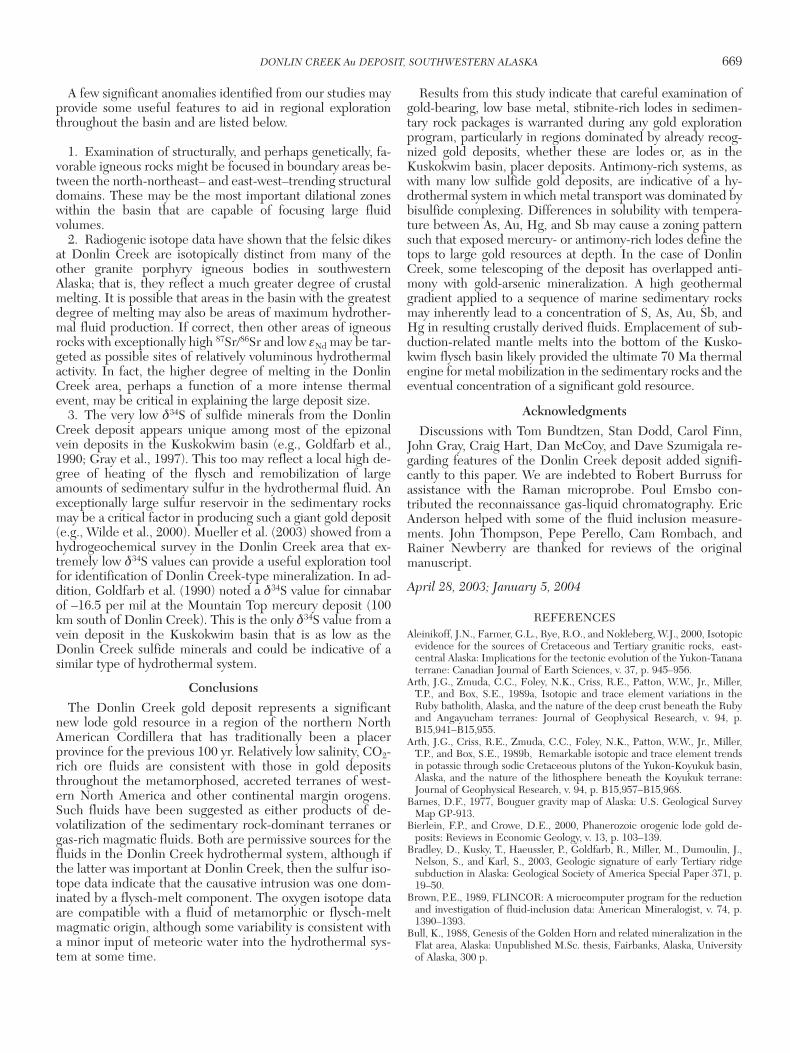
A few significant anomalies identified from our studies mayprovide some useful features to aid in regional explorationthroughout the basin and are listed below.
1. Examination of structurally, and perhaps genetically, fa-vorable igneous rocks might be focused in boundary areas be-tween the north-northeast– and east-west–trending structuraldomains. These may be the most important dilational zoneswithin the basin that are capable of focusing large fluidvolumes.
2. Radiogenic isotope data have shown that the felsic dikesat Donlin Creek are isotopically distinct from many of theother granite porphyry igneous bodies in southwesternAlaska; that is, they reflect a much greater degree of crustalmelting. It is possible that areas in the basin with the greatestdegree of melting may also be areas of maximum hydrother-mal fluid production. If correct, then other areas of igneousrocks with exceptionally high 87Sr/86Sr and low εNd may be tar-geted as possible sites of relatively voluminous hydrothermalactivity. In fact, the higher degree of melting in the DonlinCreek area, perhaps a function of a more intense thermalevent, may be critical in explaining the large deposit size.
3. The very low δ34S of sulfide minerals from the DonlinCreek deposit appears unique among most of the epizonalvein deposits in the Kuskokwim basin (e.g., Goldfarb et al.,1990; Gray et al., 1997). This too may reflect a local high de-gree of heating of the flysch and remobilization of largeamounts of sedimentary sulfur in the hydrothermal fluid. Anexceptionally large sulfur reservoir in the sedimentary rocksmay be a critical factor in producing such a giant gold deposit(e.g., Wilde et al., 2000). Mueller et al. (2003) showed from ahydrogeochemical survey in the Donlin Creek area that ex-tremely low δ34S values can provide a useful exploration toolfor identification of Donlin Creek-type mineralization. In ad-dition, Goldfarb et al. (1990) noted a δ34S value for cinnabarof –16.5 per mil at the Mountain Top mercury deposit (100km south of Donlin Creek). This is the only δ34S value from avein deposit in the Kuskokwim basin that is as low as theDonlin Creek sulfide minerals and could be indicative of asimilar type of hydrothermal system.
ConclusionsThe Donlin Creek gold deposit represents a significant
new lode gold resource in a region of the northern NorthAmerican Cordillera that has traditionally been a placerprovince for the previous 100 yr. Relatively low salinity, CO2-rich ore fluids are consistent with those in gold depositsthroughout the metamorphosed, accreted terranes of west-ern North America and other continental margin orogens.Such fluids have been suggested as either products of de-volatilization of the sedimentary rock-dominant terranes orgas-rich magmatic fluids. Both are permissive sources for thefluids in the Donlin Creek hydrothermal system, although ifthe latter was important at Donlin Creek, then the sulfur iso-tope data indicate that the causative intrusion was one dom-inated by a flysch-melt component. The oxygen isotope dataare compatible with a fluid of metamorphic or flysch-meltmagmatic origin, although some variability is consistent witha minor input of meteoric water into the hydrothermal sys-tem at some time.
Results from this study indicate that careful examination ofgold-bearing, low base metal, stibnite-rich lodes in sedimen-tary rock packages is warranted during any gold explorationprogram, particularly in regions dominated by already recog-nized gold deposits, whether these are lodes or, as in theKuskokwim basin, placer deposits. Antimony-rich systems, aswith many low sulfide gold deposits, are indicative of a hy-drothermal system in which metal transport was dominated bybisulfide complexing. Differences in solubility with tempera-ture between As, Au, Hg, and Sb may cause a zoning patternsuch that exposed mercury- or antimony-rich lodes define thetops to large gold resources at depth. In the case of DonlinCreek, some telescoping of the deposit has overlapped anti-mony with gold-arsenic mineralization. A high geothermalgradient applied to a sequence of marine sedimentary rocksmay inherently lead to a concentration of S, As, Au, Sb, andHg in resulting crustally derived fluids. Emplacement of sub-duction-related mantle melts into the bottom of the Kusko-kwim flysch basin likely provided the ultimate 70 Ma thermalengine for metal mobilization in the sedimentary rocks and theeventual concentration of a significant gold resource.
AcknowledgmentsDiscussions with Tom Bundtzen, Stan Dodd, Carol Finn,
John Gray, Craig Hart, Dan McCoy, and Dave Szumigala re-garding features of the Donlin Creek deposit added signifi-cantly to this paper. We are indebted to Robert Burruss forassistance with the Raman microprobe. Poul Emsbo con-tributed the reconnaissance gas-liquid chromatography. EricAnderson helped with some of the fluid inclusion measure-ments. John Thompson, Pepe Perello, Cam Rombach, andRainer Newberry are thanked for reviews of the originalmanuscript.
April 28, 2003; January 5, 2004
REFERENCESAleinikoff, J.N., Farmer, G.L., Rye, R.O., and Nokleberg, W.J., 2000, Isotopic
evidence for the sources of Cretaceous and Tertiary granitic rocks, east-central Alaska: Implications for the tectonic evolution of the Yukon-Tananaterrane: Canadian Journal of Earth Sciences, v. 37, p. 945–956.
Arth, J.G., Zmuda, C.C., Foley, N.K., Criss, R.E., Patton, W.W., Jr., Miller,T.P., and Box, S.E., 1989a, Isotopic and trace element variations in theRuby batholith, Alaska, and the nature of the deep crust beneath the Rubyand Angayucham terranes: Journal of Geophysical Research, v. 94, p.B15,941–B15,955.
Arth, J.G., Criss, R.E., Zmuda, C.C., Foley, N.K., Patton, W.W., Jr., Miller,T.P., and Box, S.E., 1989b, Remarkable isotopic and trace element trendsin potassic through sodic Cretaceous plutons of the Yukon-Koyukuk basin,Alaska, and the nature of the lithosphere beneath the Koyukuk terrane:Journal of Geophysical Research, v. 94, p. B15,957–B15,968.
Barnes, D.F., 1977, Bouguer gravity map of Alaska: U.S. Geological SurveyMap GP-913.
Bierlein, F.P., and Crowe, D.E., 2000, Phanerozoic orogenic lode gold de-posits: Reviews in Economic Geology, v. 13, p. 103–139.
Bradley, D., Kusky, T., Haeussler, P., Goldfarb, R., Miller, M., Dumoulin, J.,Nelson, S., and Karl, S., 2003, Geologic signature of early Tertiary ridgesubduction in Alaska: Geological Society of America Special Paper 371, p.19–50.
Brown, P.E., 1989, FLINCOR: A microcomputer program for the reductionand investigation of fluid-inclusion data: American Mineralogist, v. 74, p.1390–1393.
Bull, K., 1988, Genesis of the Golden Horn and related mineralization in theFlat area, Alaska: Unpublished M.Sc. thesis, Fairbanks, Alaska, Universityof Alaska, 300 p.
DONLIN CREEK Au DEPOSIT, SOUTHWESTERN ALASKA 669
0361-0128/98/000/000-00 $6.00 669
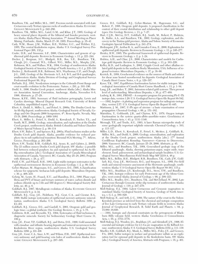
Bundtzen, T.K., and Miller, M.L., 1997, Precious metals associated with LateCretaceous-early Tertiary igneous rocks of southwestern Alaska: ECONOMICGEOLOGY MONOGRAPH 9, p. 242–286.
Bundtzen, T.K., Miller, M.L., Laird, G.M., and Kline, J.T., 1985, Geology ofheavy mineral placer deposits of the Iditarod and Innoko precincts, west-ern Alaska: Alaska Placer Mining Association, 7th Annual Meeting on PlacerMining, Fairbanks, Alaska, March 27–30, 1985, Proceedings, p. 35–41
Cady, W.M., Hoare, J.M., Wallace, R.E., Webber, G.C., and Webber, E.J.,1955, The central Kuskokwim region, Alaska: U.S. Geological Survey Pro-fessional Paper 268, 132 p.
Cooke, D.R., and Simmons, S.F., 2000, Characteristics and genesis of ep-ithermal gold deposits: Reviews in Economic Geology, v. 13, p. 221–244.
Decker, J., Bergman, S.C., Blodgett, R.B., Box, S.E., Bundtzen, T.K.,Clough, J.G., Coonrad, W.L., Gilbert, W.G., Miller, M.L., Murphy, J.M.,Robinson, M.S., and Wallace, W.K., 1994, Geology of southwestern Alaska:Geological Society of America, Geology of North America, v. G-1, p. 235–310
Decker, J., Reifenstuhl, R.R., Robinson, M.S., Waythomas, C.F., and Clough,J.G., 1995, Geology of the Sleetmute A-5, A-6, B-5, and B-6 quadrangles,southwestern Alaska: Alaska Division of Geology and Geophysical SurveysProfessional Report 99, 16 p.
DePaolo, D.J., 1981, Neodymium isotopes in the Colorado Front Range andcrust-mantle evolution in the Proterozoic: Nature, v. 291, p. 193–196.
Dodd, S., 1996, Donlin Creek project, southwest Alaska [abs.]: Alaska Min-ers Association Annual Convention, Anchorage, Alaska, November 6–8,1996, Abstracts, p. 27–28.
Dunne, K.P.E., 1993, Summary of fluid inclusion petrography, Lewis andCarolyn showings: Mineral Deposit Research Unit, University of BritishColumbia, unpublished report, 10 p.
Ebert, S., Dodd, S., Miller, L., and Petsel, S., 2000a, The Donlin Creek Au-As-Sb-Hg deposit, southwestern Alaska: Geological Society of Nevada, Ge-ology and Ore Deposits 2000 Symposium, 4th, Reno-Sparks, Nevada, May15-18, 2000, Proceedings, p. 1069–1081
Ebert, S., Miller, L., Petsel, S., Dodd, S., Kowalczyk, P., Tucker, T.L., andSmith, M.T., 2000b, Geology, mineralization, and exploration at the DonlinCreek project, southwestern Alaska: British Columbia and Yukon Chamberof Mines Special Volume 2, p. 99–114
Ebert, S.W., Baker, T., and Spencer, R.J., 2003a, Fluid inclusion studies at theDonlin Creek gold deposit, Alaska, possible evidence for reduced por-phyry-Au to sub-epithermal transition: Biennial SGA Meeting, 7th, Athens,Greece, Proceedings, p. 263–266.
Ebert, S.W., Tosdal, R.M., Goldfarb, R.J., Ayuso, R., and Gabites, J., 2003b,The 23 million ounces Donlin Creek gold deposit, SW Alaska—a possiblelink between reduced porphyry Au and epizonal to epithermal Au-As-Sb-Hg mineralization [abs.]: Geological Association of Canada-MineralogicalAssociation of Canada, Vancouver, BC, Canada, May 25–28, 2003, Programwith Abstracts, v. 28, p. 477.
Field, C.W., and Fifarek, R.H., 1985, Light stable-isotopes systematics in theepithermal environment: Reviews in Economic Geology, v. 2, p. 99–128.
Gebre-Mariam, M., Hagemann, S.G., and Groves, D.I., 1995, A classificationscheme for epigenetic Archaean lode-gold deposits: Mineralium Deposita,v. 30, p. 408–410.
Gehrig, M., Lentz, H., Franck, E.U., and Hamilton, D.L., 1980, Phase equi-libria and PVT of binary and ternary mixtures of water, carbon dioxide andsodium chloride up to 3 kb and 550 degrees C: Mineralogical Society Bul-letin, no. 49, p. 6.
Goldfarb, R.J., 1997, Metallogenic evolution of Alaska: ECONOMIC GEOLOGYMONOGRAPH 9, p. 4–34.
Goldfarb, R.J., Gray, J.E., Pickthorn, W.J., Gent, C.A., and Cieutat, B.A.,1990, Stable isotope systematics of epithermal mercury-antimony mineral-ization, southwestern Alaska: U.S. Geological Survey Bulletin 1950, p.E1–E9.
Goldfarb, R.J., Groves, D.I., and Gardoll, S., 2001, Orogenic gold and geo-logic time—a global synthesis: Ore Geology Reviews, v. 18, p. 1–75.
Goldstein, R.H., and Reynolds, T.J., 1994, Systematics of fluid inclusions indiagenetic minerals: Society for Sedimentary Geology Short Course 31,199 p.
Gray, J.E., Frost, T.P., Goldfarb, R.J., and Detra, D.E., 1990, Gold associatedwith cinnabar- and stibnite-bearing deposits and mineral occurrences in theKuskokwim River region, southwestern Alaska: U.S. Geological SurveyBulletin 1950, p. D1–D6
Gray, J.E., Gent, C.A., Snee, L.W., and Wilson, F.H., 1997, Epithermal mer-cury-antimony and gold-bearing vein lodes of southwestern Alaska: ECO-NOMIC GEOLOGY MONOGRAPH 9, p. 287–305.
Groves, D.I., Goldfarb, R.J., Gebre-Mariam, M., Hagemann, S.G., andRobert, F., 1998, Orogenic gold deposits: A proposed classification in thecontext of their crustal distribution and relationship to other gold deposittypes: Ore Geology Reviews, v. 13, p. 7–27.
Hart, C.J.R., McCoy, D.T., Goldfarb, R.J., Smith, M., Robert, P., Hulstein,R., Bakke, A.A., and Bundtzen, T.K., 2002, Geology, exploration, and dis-covery in the Tintina gold province, Alaska and Yukon: Society of EconomicGeologists Special Publication 9, p. 241–274.
Hedenquist, J.W., Arribas R, A., and Gonzalez-Urien, E., 2000, Exploration forepithermal gold deposits: Reviews in Economic Geology, v. 13, p. 245–277.
Henley, R.W., 1985, The geothermal framework of epithermal deposits: Re-views in Economic Geology, v. 2, p. 1–24.
Hofstra, A.H., and Cline, J.S., 2000, Characteristics and models for Carlin-type gold deposits: Reviews in Economic Geology, v. 13, p. 163–220.
Kelley, K.D., and Ludington, S., 2002, Cripple Creek and other alkaline-re-lated gold deposits in the southern Rocky Mountains, USA: Influence of re-gional tectonics: Mineralium Deposita, v. 37, p. 38–60.
Kerrich, R., 1989, Geochemical evidence on the sources of fluids and solutesfor shear zone hosted mesothermal Au deposits: Geological Association ofCanada Short Course Notes, v. 6, p. 129–197.
Kyser, T.K., 1987, Equilibrium fractionation factors for stable isotopes: Min-eralogical Association of Canada Short Course Handbook, v. 13, p. 1–84.
Lang, J.R., and Baker, T., 2001, Intrusion-related gold systems: Then presentlevel of understanding: Mineralium Deposita, v. 36, p. 477–489.
Ludwig, K. R., 1991, PBDAT—A computer program for processing Pb-U-Thisotope data, version 1.20: U.S. Geological Survey Open-file Report 88-542.
——1992, Isoplot—A plotting and regression program for radiogenic-isotopedata, version 2.57: U.S. Geological Survey Open-file Report 91-445.
Mattinson, J. M., 1987, U-Pb ages of zircons—a basic examination of errorpropagation: Chemical Geology, v. 66, p. 151–162.
Matsuhisa, Y., Goldsmith, J.R., and Clayton, R.N., 1979, Oxygen isotopicfractionation in the system quartz-albite-anorthite-water: Geochimica etCosmochimica Acta, v. 43, p. 1131–1140.
Mernagh, T.P., and Trudu, A.G., 1993, A laser Raman microprobe study ofsome geologically important sulphide minerals: Chemical Geology, v. 103,p. 113–127.
Miller, L.D., Ebert, S., Kowalczyk, P., Petsel, S., McAtee, J., Goldfarb, R.,Miller, M.L., and Dodd, S., 2000, Geology, mineralization, and explorationat the Donlin Creek project, southwestern Alaska [abs.]: 17th AnnualCordilleran Exploration Roundup, Vancouver—Gateway to Discoveries,2000, Vancouver, BC, Canada, January 25–28, 2000, Abstracts, p. 45.
Miller, M.L., and Bundtzen, T.K., 1994, Generalized geologic map of theIditarod quadrangle, Alaska, showing potassium-argon, major oxide, traceelement, fossil, paleocurrent, and archaeological sample localities: U.S. Ge-ological Survey Miscellaneous Field Study Map MF-2219-A, 48 p.
Miller, M.L., Belkin, H.E., Blodgett, R.B., Bundtzen, T.K., Cady, J.W., Gold-farb, R.J., Gray, J.E., McGimsey, R.G., and Simpson, S.L., 1989, Pre-fieldstudy and mineral resource assessment of the Sleetmute quadrangle, south-western Alaska: U.S Geological Survey Open-file Report 89-363, 115 p.
Miller, M.L., Bradshaw, J.Y., Kimbrough, D.L., Stern, T.W., and Bundtzen,T.K., 1991, Isotopic evidence for early Proterozoic age of the Idono Com-plex, west-central Alaska: Journal of Geology, v. 99, p. 209–223.
Miller, M.L., Bradley, D.C., Bundtzen, T.K., and McClelland, W., 2002, LateCretaceous through Cenozoic strike-slip tectonics of southwestern Alaska:Journal of Geology, v. 110, p. 247–270.
Moll-Stalcup, E.J., 1994, Latest Cretaceous and Cenozoic magmatism inmainland Alaska: Geological Society of America, Geology of North Amer-ica, v. G-1, p. 589–620.
Moll-Stalcup, E., and Arth, J. G., 1989, The nature of the crust in the Yukon-Koyukuk province as inferred from the chemical and isotopic compositionof five Late Cretaceous to early Tertiary volcanic fields in western Alaska:Journal of Geophysical Research, B, Solid Earth and Planets, v. 94, p.15,989–16,020.
——1991, Isotopic and chemical constraints on the petrogenesis of Black-burn Hills volcanic field, western Alaska: Geochimica et CosmochimicaActa, v. 55, p. 3753–3776.
Moll-Stalcup, E.J., Wooden, J.L., Bradshaw, J.Y., and Aleinikoff, J.N., 1996, El-emental and isotopic evidence for 2.1-Ga arc magmatism in the Kilbuck ter-rane, southwestern Alaska: U.S. Geological Survey Bulletin 2152, p. 111–130.
Mueller, S.H., Goldfarb, R.J., Munk, L., Miller, M.L., Foley, J.Y., and Gemery,P.A., 2003, Sulfur isotopes in surface and groundwater sulfate as an explo-ration tool for epizonal gold deposits in the Kuskokwim basin, SW Alaska[abs.]: Geological Society of America, Abstracts with Programs, v. 35, p. 401.
670 GOLDFARB ET AL.
0361-0128/98/000/000-00 $6.00 670
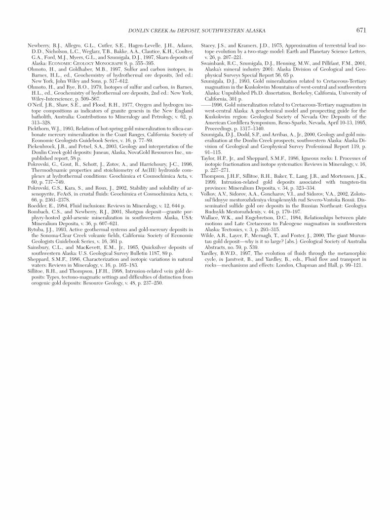
Newberry, R.J., Allegro, G.L., Cutler, S.E., Hagen-Levelle, J.H., Adams,D.D., Nicholson, L.C., Weglarz, T.B., Bakke, A.A., Clautice, K.H., Coulter,G.A., Ford, M.J., Myers, G.L., and Szumigala, D.J., 1997, Skarn deposits ofAlaska: ECONOMIC GEOLOGY MONOGRAPH 9, p. 355–395.
Ohmoto, H., and Goldhaber, M.B., 1997, Sulfur and carbon isotopes, inBarnes, H.L., ed., Geochemistry of hydrothermal ore deposits, 3rd ed.:New York, John Wiley and Sons, p. 517–612.
Ohmoto, H., and Rye, R.O., 1979, Isotopes of sulfur and carbon, in Barnes,H.L., ed., Geochemistry of hydrothermal ore deposits, 2nd ed.: New York,Wiley-Interscience, p. 509–567.
O’Neil, J.R., Shaw, S.E., and Flood, R.H., 1977, Oxygen and hydrogen iso-tope compositions as indicators of granite genesis in the New Englandbatholith, Australia: Contributions to Mineralogy and Petrology, v. 62, p.313–328.
Pickthorn, W.J., 1993, Relation of hot-spring gold mineralization to silica-car-bonate mercury mineralization in the Coast Ranges, California: Society ofEconomic Geologists Guidebook Series, v. 16, p. 77–89.
Piekenbrock, J.R., and Petsel, S.A., 2003, Geology and interpretation of theDonlin Creek gold deposits: Juneau, Alaska, NovaGold Resources Inc., un-published report, 58 p.
Pokrovski, G., Gout, R., Schott, J., Zotov, A., and Harrichoury, J-C., 1996,Thermodynamic properties and stoichiometry of As(III) hydroxide com-plexes at hydrothermal conditions: Geochimica et Cosmochimica Acta, v.60, p. 737–749.
Pokrovski, G.S., Kara, S., and Roux, J., 2002, Stability and solubility of ar-senopyrite, FeAsS, in crustal fluids: Geochimica et Cosmochimica Acta, v.66, p. 2361–2378.
Roedder, E., 1984, Fluid inclusions: Reviews in Mineralogy, v. 12, 644 p.Rombach, C.S., and Newberry, R.J., 2001, Shotgun deposit—granite por-
phyry-hosted gold-arsenic mineralization in southwestern Alaska, USA:Mineralium Deposita, v. 36, p. 607–621.
Rytuba, J.J., 1993, Active geothermal systems and gold-mercury deposits inthe Sonoma-Clear Creek volcanic fields, California: Society of EconomicGeologists Guidebook Series, v. 16, 361 p.
Sainsbury, C.L., and MacKevett, E.M., Jr., 1965, Quicksilver deposits ofsouthwestern Alaska: U.S. Geological Survey Bulletin 1187, 89 p.
Sheppard, S.M.F., 1986, Characterization and isotopic variations in naturalwaters: Reviews in Mineralogy, v. 16, p. 165–183.
Sillitoe, R.H., and Thompson, J.F.H., 1998, Intrusion-related vein gold de-posits: Types, tectono-magmatic settings and difficulties of distinction fromorogenic gold deposits: Resource Geology, v. 48, p. 237–250.
Stacey, J.S., and Kramers, J.D., 1975, Approximation of terrestrial lead iso-tope evolution by a two-stage model: Earth and Planetary Science Letters,v. 26, p. 207–221.
Swainbank, R.C., Szumigala, D.J., Henning, M.W., and Pillifant, F.M., 2001,Alaska’s mineral industry 2001: Alaska Division of Geological and Geo-physical Surveys Special Report 56, 65 p.
Szumigala, D.J., 1993, Gold mineralization related to Cretaceous-Tertiarymagmatism in the Kuskokwim Mountains of west-central and southwesternAlaska: Unpublished Ph.D. dissertation, Berkeley, California, University ofCalifornia, 301 p.
——1996, Gold mineralization related to Cretaceous-Tertiary magmatism inwest-central Alaska: A geochemical model and prospecting guide for theKuskokwim region: Geological Society of Nevada Ore Deposits of theAmerican Cordillera Symposium, Reno-Sparks, Nevada, April 10-13, 1995,Proceedings, p. 1317–1340.
Szumigala, D.J., Dodd, S.P., and Arribas, A., Jr., 2000, Geology and gold min-eralization at the Donlin Creek prospects, southwestern Alaska: Alaska Di-vision of Geological and Geophysical Survey Professional Report 119, p.91–115.
Taylor, H.P., Jr., and Sheppard, S.M.F., 1986, Igneous rocks: I. Processes ofisotopic fractionation and isotope systematics: Reviews in Mineralogy, v. 16,p. 227–271.
Thompson, J.H.F., Sillitoe, R.H., Baker, T., Lang, J.R., and Mortensen, J.K.,1999, Intrusion-related gold deposits associated with tungsten-tinprovinces: Mineralium Deposita, v. 34, p. 323–334.
Volkov, A.V., Sidorov, A.A., Goncharov, V.I., and Sidorov, V.A., 2002, Zoloto-sul’fidnyye mestorozhdeniya vkraplennykh rud Severo-Vostoka Rossii. Dis-seminated sulfide gold ore deposits in the Russian Northeast: GeologiyaRudnykh Mestorozhdeniy, v. 44, p. 179–197.
Wallace, W.K., and Engebretson, D.C., 1984, Relationships between platemotions and Late Cretaceous to Paleogene magmatism in southwesternAlaska: Tectonics, v. 3, p. 293–315.
Wilde, A.R., Layer, P., Mernagh, T., and Foster, J., 2000, The giant Murun-tau gold deposit—why is it so large? [abs.]: Geological Society of AustraliaAbstracts, no. 59, p. 539.
Yardley, B.W.D., 1997, The evolution of fluids through the metamorphiccycle, in Jamtveit, B., and Yardley, B., eds., Fluid flow and transport inrocks—mechanisms and effects: London, Chapman and Hall, p. 99–121.
DONLIN CREEK Au DEPOSIT, SOUTHWESTERN ALASKA 671
0361-0128/98/000/000-00 $6.00 671

0361-0128/98/000/000-00 $6.00 672


![8 Economic geology ppt [وضع التوافق]](https://img.pdfslide.net/doc/110x75/623f8d05ca7ebd60a42af959/8-economic-geology-ppt-.jpg)


![Important] FR 2 Economic Geology](https://img.pdfslide.net/doc/110x75/54e880a04a7959d76d8b4f9e/important-fr-2-economic-geology.jpg)


![3 Economic geology ppt [وضع التوافق]](https://img.pdfslide.net/doc/110x75/623f90cff5e5167dfb23ad98/3-economic-geology-ppt-.jpg)