Embed Size (px)
Citation preview

Molalla-Pudding-French Prairie-NorthSantiam Subbasins
Agricultural Water QualityManagement Area Plan
Developed byThe Molalla-Pudding-French Prairie-North Santiam
Subbasins Local Advisory Committee
with assistance from
The Oregon Department of Agricultureand
The Marion Soil and Water Conservation District
March 2004
Local Advisory Committee Members
Judy McClaughry, ChairMyron Harper, Vice-ChairJohn BirnieRicardo DaileyBob DettwylerKent Doerfler
Daniel GoffinAlan KraemerBarbara LucasJim MyronRay StaffordMatt Thorburn

Local Advisory Committee MembersName Area /
WatershedCommodity Affiliations
JudyMcClaughry,Chair
Brooks/Pudding Onions, grains Oregon Women for Agriculture,American Ag Women, MarionSWCD
MyronHarper, ViceChair
Brooks/Pudding Filberts Marion SWCD, Agri-Pac, 4-HLeaders, Livestock Assoc, OACD
John Birnie Salem Agric.consultant
RicardoDailey
Molalla Timber Columbia County SWCD
BobDettwyler
Silverton/Pudding
Grass seed,wheat, bushbeans, beef
Farm Bureau, Wilco Farmers,Oregon Wheat League, Agri-Pac
Kent Doerfler Sublimity/MillCreek
Grass seed Oregon Bentgrass Commission
Daniel Goffin Aumsville/MillCreek
Farmer,livestock
Marion SWCD, Farm Bureau,Pudding River Watershed Council
Fred Kaser Molalla/Molalla
Grass seed,hazelnuts, vegseed
Fine Fescue Commission,Irrigation Dist., OR Seed League,Wilco Farmers
Alan Kraemer Mt. Angel/Pudding
Ornamentalnursery stock
OR Association of Nurseryman,Farm Bureau, Wilco Farmers
Barbara Lucas Woodburn/Pudding
Writer City of Woodburn BudgetCommittee
Jim Myron Canby/ Molalla Environmental InterestsRay Stafford Christmas
TreesMattThorburn
CountyGovernment
Marion County Public Works

Table Of ContentsAcronyms ............................................................................................................................................................4Foreword.............................................................................................................................................................6Mission ................................................................................................................................................................6Message to Landowners and Operators from the Local Advisory Committee .........................................7Introduction........................................................................................................................................................8
Strategy for Public Participation............................................................................................................9Background ......................................................................................................................................................10
History ..................................................................................................................................................10Geographical and Physical Setting................................................................................................................21Water Resources ..............................................................................................................................................26
Water Quantity .....................................................................................................................................26Present Water Use ................................................................................................................................29Water Quality .......................................................................................................................................32Biological Resources............................................................................................................................36
Mission, Goals, and Objectives ......................................................................................................................39Mission .................................................................................................................................................39Goals and Objectives ...........................................................................................................................39
Plan Implementation .......................................................................................................................................42Education..............................................................................................................................................42
Voluntary Water Quality Farms Plans and Conservation Planning ........................................................44Funding.................................................................................................................................................45Monitoring and Evaluation ..................................................................................................................46
Rule Compliance..............................................................................................................................................47Prevention and Control Measures........................................................................................................47
Definitions..........................................................................................................................................................48Chemigated Irrigation Water.............................................................................................................................51Surface Drainage and Irrigation Ditches...........................................................................................................52Erosion Prevention and Sediment Control........................................................................................................53Irrigation.............................................................................................................................................................54Waste: Livestock and Other .............................................................................................................................55Nutrients.............................................................................................................................................................56Pesticides............................................................................................................................................................57Riparian Management Area (RMA)..................................................................................................................58Road and Staging Areas ....................................................................................................................................59Approval of a Voluntary Water Quality Farm Plan...................................................................................60
Enforcement Actions and Resolutions of Complaints ........................................................................60Acknowledgements & Bibliography..............................................................................................................64Bibliography .....................................................................................................................................................65References .........................................................................................................................................................66Appendices........................................................................................................................................................68
Appendix A: Educational and Technical Services for Natural resource and Farm Management....70Appendix B: The Conservation Reserve Enhancement Program......................................................72Appendix C: The Conservation Planning Process .............................................................................77Appendix D: Instructions and Guidelines for a Voluntary Plan........................................................78Appendix E: Description of Healthy Riparian Management.............................................................80Appendix F: Erosion Visual Indicators and Measurement................................................................82Appendix G: ORS 468B.025 and 468B.050 – Oregon Water Pollution Control Law.....................84Appendix H: Willamette River Basin Water Quality Study..............................................................85

Blank

Molalla-Pudding-French Prairie-North Santiam Subbasins Area Plan March 2004 Page 4
ACRONYMS
AgWQM Agricultural Water Quality ManagementArea Rule Agricultural Water Quality Management Area RuleArea Plan Agricultural Water Quality Management Area PlanCREP Conservation Reserve Enhancement ProgramCRP Conservation Reserve ProgramDEQ Department of Environmental QualityLAC Local Advisory CommitteeLMA Local Management AgencyNO3 NitrateNPS Nonpoint SourceNRCS Natural Resources Conservation ServiceOAR Oregon Administrative RuleODA Oregon Department of AgricultureORS Oregon Revised StatuteOSU Oregon State UniversityPCM Prevention and Control MeasureRMA Riparian Management AreaSB Senate BillSWCD Soil and Water Conservation DistrictTMDL Total Maximum Daily LoadTP Total PhosphorousUSDA United States Department of AgricultureVoluntary Plans Voluntary Water Quality Farm Plans

Molalla-Pudding-French Prairie-North Santiam Subbasins Area Plan March 2004 Page 5
Blank

Molalla-Pudding-French Prairie-North Santiam Subbasins Area Plan March 2004 Page 6
FOREWORDThis Molalla-Pudding-French Prairie-North Santiam Agricultural Water Quality ManagementArea Plan (Area Plan) provides guidance for addressing agricultural water quality issues in theMolalla-Pudding-French Prairie-North Santiam Agricultural Water Quality Management Area(Management Area). The purpose of this Area Plan is to identify strategies to reduce waterpollution from agricultural lands through a combination of educational programs, suggested landtreatments, management activities, and monitoring.
The provisions of this Area Plan do not establish legal requirements or prohibitions.
The Oregon Department of Agriculture (ODA) will exercise its enforcement authority for theprevention and control of water pollution from agricultural activities under OregonAdministrative Rules (OAR) for the Molalla-Pudding-French Prairie-North SantiamManagement Area (OAR 603-095-1900 through 603-095-1980) and Oregon AdministrativeRules 603-090-0000 through 603-090-0120.
The administrative rules for the Molalla-Pudding-French Prairie-North Santiam ManagementArea set forth the requirements and/or prohibitions that will be used by ODA in exercising itsenforcement authority for the prevention and control of water pollution from agriculturalactivities. In addition, Oregon Administrative Rules 603-090-0060 through 603-090-0120describe the enforcement actions that may be triggered upon the finding of a violation by theODA.
MISSIONThe mission of the plan is to promote agricultural management practices that protect andimprove water quality in the Molalla River, Pudding River, North Santiam River, Santiam River,Mill Creek and French Prairie Area subbasins while maintaining agricultural viability.

Molalla-Pudding-French Prairie-North Santiam Subbasins Area Plan March 2004 Page 7
MESSAGE TO LANDOWNERS AND OPERATORSFROM THE LOCAL ADVISORY COMMITTEEThe Area Plan and the administrative rules for this Management Area convey agriculture's role inthe statewide Oregon effort for achieving water quality standards and the protection of beneficialuses. It is intended that, combined with other efforts throughout the planning area with otherland uses -- urban, rural residential, forestry, industrial -- implementation of this plan will aid inachievement of water quality standards. It is important that landowners are aware that "waters ofthe state" (described on page 38) are public waters, and landowners have a responsibility toassure that they are not causing pollution.
The focus of this Area Plan is on education and incentives to promote voluntary actions toprotect and improve water quality. This means that each landowner/operator will have todo their part. Each landowner/operator must make a commitment to include water qualityconsiderations as part of their land management decisions. It will take a high degree oflandowner/operator responsibility to make this Area Plan work for everyone inagriculture.
This Area Plan and the administrative rules will be reviewed and adapted every two years andwill become part of the Management Area strategy to address the Total Maximum Daily Loads(TMDLs). TMDLs are established through a public process by the Oregon Department ofEnvironmental Quality for waterbodies that violate state water quality standards. Eventually, theplan and rules will be combined with the management plans for the other land uses that addressthe TMDLs into one document. This document will represent the State's plan to meet theTMDLs and improve water quality, and will be forwarded for approval to the U.S.Environmental Protection Agency (EPA). If TMDLs for a waterbody are approved, the OregonDepartment of Environmental Quality may remove it from the federal Clean Water Act section303(d) list of impaired waterways.
The State and Federal governments have joined to offer landowners/operators a voluntaryprogram of financial and material incentives to improve streamside areas. This voluntaryprogram is called the Conservation Reserve Enhancement Program (CREP). CREP can serve tohelp a landowner/operator to keep streams cool, improve streambank stability (and protectproperty and property values), and filter out sediment and attached farm chemicals and bacteria.Additional information about CREP is provided in Appendix B. Appendix A provides localcontacts for landowners/operators interested in the program.

Molalla-Pudding-French Prairie-North Santiam Subbasins Area Plan March 2004 Page 8
INTRODUCTIONThis document is the Molalla-Pudding-French Prairie-North Santiam Agricultural Water QualityManagement Area Plan for the enhancement of water quality from agricultural activities in thisManagement Area. It provides guidance for agriculture to meet or exceed water qualitystandards set by the Oregon Environmental Quality Commission, as required by the federalClean Water Act, while maintaining agricultural viability. This Area Plan applies to all thewatersheds in Marion County, that portion of the Pudding River in Clackamas County, thatportion of the North Santiam and Santiam Rivers in Linn County and that portion of the MolallaRiver in Clackamas County.
This Area Plan was created pursuant to Senate Bill (SB) 1010, passed by the 1993 OregonLegislature. This Area Plan was developed through a cooperative effort of the Local AdvisoryCommittee (LAC), Oregon Department of Agriculture, and the Marion Soil and WaterConservation District, with assistance from the Clackamas Soil and Water Conservation Districtand Linn Soil and Water Conservation District. The LAC consists of affectedlandowners/operators, a city representative, a county representative and an environmentalrepresentative. The committee is comprised of 15 members and three alternates. Themembership is predominantly affected agricultural producers in the Management Arearepresenting the diversity of the 200 plus agricultural commodities grown.
This Area Plan applies to all lands, regardless of size, within the described watersheds currentlyin agricultural use. For example, the Area Plan applies equally to large commercial productionlands and to small rural lands grazing a few animals. It also applies to all agricultural lands,which are lying idle, or on which management has been deferred. While the Area Plan willapply to grazing in forest areas, timber harvesting activities subject to the Forest Practices Actare not subject to this plan.
The Oregon Legislature, in passing Senate Bill 1010, authorized the Oregon Department ofAgriculture to develop and carry out a water quality management plan for any agricultural orrural land area where a water quality management plan is required by state or federal law. In1995 with SB 502, the Oregon Legislature designated the Oregon Department of Agriculture tobe the lead state agency working with agriculture to address agricultural water pollution, andgave ODA the sole authority to regulate agricultural activities pertaining to water quality.
A commitment for healthy streams and improved habitat for threatened and endangered aquaticspecies was developed by the State of Oregon in 1997, known as the Oregon Plan for Salmonand Watersheds. Senate Bill 1010 has been incorporated into the Oregon Plan for Salmon andWatersheds to be agriculture's response to water quality issues associated with the salmondecline. The ODA is committed to develop and implement Area Plans for every subbasin in theState of Oregon over a four-year period ending in July of 2002. This Area Plan is part of thatcommitment.
The ODA is the “Designated Management Agency” for agricultural pollution control activitieson agricultural and rural lands. In turn, through a Memorandum of Agreement, the Departmentof Agriculture expects to designate the Marion, Clackamas, and Linn Soil and Water

Molalla-Pudding-French Prairie-North Santiam Subbasins Area Plan March 2004 Page 9
Conservation Districts as its agricultural Local Management Agencies for implementation of theagricultural and rural water quality program and projects in the Molalla River, Pudding River,Santiam River, North Santiam River, Mill Creek and French Prairie Area Subbasins, accordingto each district's jurisdiction.
Meeting water quality standards will be accomplished by controlling pollution as close to thesource as possible. Creating a high level of awareness and understanding of water quality issuesamong the agribusiness community and the rural public through education and technicalassistance activities and promoting improved agricultural management will be the main ways toachieve pollution control closer to the source. A vital component for success will be adequatefunding secured for administration and implementation of the plan program. Monitoring andevaluation will be necessary to determine the effectiveness of this Area Plan over time.
Soil and Water Conservation Districts have a long standing record of effectively identifyingconservation concerns, developing action plans to address problems, and facilitating assistance toagriculture operators who voluntarily participate in conservation programs. Soil and WaterConservation District directors are elected from the local area and provide an avenue for citizensto participate in conservation efforts. Soil and Water Conservation Districts work cooperativelywith the United States Department of Agriculture (USDA) Natural Resources ConservationService (formerly Soil Conservation Service), USDA Farm Service Agency, Oregon StateUniversity (OSU), and other state and federal agencies. These agencies provide technical,financial, and educational assistance to individual agricultural landowners/operators for theinstallation of conservation practices, including pollution control practices. Soil and WaterConservation Districts are the catalyst for development of partnerships between local agencies,volunteer organizations, and private land owners/operators to address natural resource andconservation issues.
STRATEGY FOR PUBLIC PARTICIPATION
The draft Area Plan and Rules resulting from the efforts of the Molalla-Pudding-French Prairie-North Santiam Local Advisory Committee and the Oregon Department of Agriculture will bepresented to the State Board of Agriculture for their review and consultation.
After the State Board of Agriculture review, the draft plan and the associated rules will bepresented to the public through informational meetings and public hearings within theagricultural and rural portions of the Molalla-Pudding-French Prairie-North Santiam Subbasins.Testimony presented at public hearings and during the public comment period will be reviewedby the Local Advisory Committee and the Oregon Department of Agriculture. Recommendedmodifications will be presented to the Board of Agriculture and the director of the ODA for theirreview. The final rules resulting from this review will be adopted through the AdministrativeRules process by the director of the ODA.

Molalla-Pudding-French Prairie-North Santiam Subbasins Area Plan March 2004 Page 10
BACKGROUNDHISTORY
FARMING IN MARION COUNTY: A GLIMPSE AT NOW AND THEN1
Introduction
In this section the LAC describes the rich history of agriculture in this area, and how agricultureis an important endeavor, providing a vital economic stimulus to the area (Table 1). However, itis a difficult and chancy enterprise, with an increasingly older farm population taking greatfinancial risks for ever decreasing returns (Table 2). Yet this area's farmers continue topersevere, following tradition while experimenting with new farming methods in the hope thatthings will get better. Within this context farmers are facing new water quality demands.
1this subsection written by Barbara Lucas, Local Advisory Committee member. Please seeAcknowledgements and Bibliography section for information sources

Molalla-Pudding-French Prairie-North Santiam Subbasins Area Plan March 2004 Page 11
Table 1: Agricultural Commodity Sales ($) Marion County, 1998
Commodity Sales
Nursery 91 millionGrass seed 71 millionVegetables 51 millionDairy 45 millionBerries 35 millionGreenhouses 31 millionXmas trees 30 millionHorticulture 25 millionEggs 20 millionHops 16 millionSpec Field crops 8 millionTree fruits 7 millionCattle 6 millionStraw 6 millionHazelnuts 5 millionPoultry 5 millionMink 4 millionLivestock 3 millionHay/forage 3 millionCereal 1 million
TOTAL $463 millionOSU Extension Service, Economic Information Office 4/18/00
Table 2: Bits and Pieces
275,250 Population of Marion Co. 2,546 Number of farms in Marion Co. 6,136 Farm population (2.41 per household) 1,210 Operators receiving principal income from farming 1,336 Operators receiving principal income from other306,083 Acres being farmed 70,000 Acres irrigated regularly 15,000 Acres irrigated occasionally 200 Potential crops 87 Crops raised 54 Average age of farmer 2.83% Annual return on investment $ 8.08 Per hour wage rate
USDA '97 Census, Oregon Department of Agriculture,OSU Marion County Extension Service,Mid-Willamette Valley Council of Governments.

Molalla-Pudding-French Prairie-North Santiam Subbasins Area Plan March 2004 Page 12
The Land
The destination of early settlers in the Oregon Country was the land east of the Willamette Riverand south to present-day Salem in Marion County. This prairie land was fringed with forests, butthe prairies themselves had few trees and little brush. Dr. John McLoughlin and one of hisHudson Bay Company employees pronounced this prairie land the Northwest's most desirableregion for settlement. According to an early day traveler, Rev. Samuel Parker, the soil wasalluvial river bottom; rich, easy to cultivate, sufficiently dry for cultivation, yet well watered bysmall streams and springs. French Prairie is the largest of these prairies.
At the south end of French Prairie, north of Salem and east of Keizer, is Lake Labishbottomlands, a one-time swamp left over from an old bed of the Willamette River. A publicationcalled "Black Gold" reports that Lake Labish was discovered in 1848 by a French Prairie settler.It is about 10 miles long and one-half mile at its widest, 1270 acres of peat created by decayedvegetation. The peat is four feet to eight feet deep. Surrounding the swamp were woodlands offir, pine and oak, but the swamp itself contained willow, ash, vine maple, cattails, skunkcabbage, cottonwoods, and many beaver dams. Because of its swampiness, no one filed adonation land claim, and the State later sold the property for $1 an acre.
Anecdotes. Early stagecoaches avoided the swamp, bypassing the lake about a half milenorthwest of the Chemawa Indian School.... A Marion County engineer reportedly shoved a 2" x6" sixteen feet into the peat with his bare hands and never touched bottom.... according to oneresident Lake Labish soil is even more fertile than French Prairie.
The highlands southwest of Silver Creek Falls Park is a stretch of land described by historianMark Schmid as a fairyland of majestic timber, white water and wild flowers, a primeval forestwith Indian trails and mountain streams abounding in fish. These highlands and the lowlandsaround neighboring Mill Creek provide the setting for farms and the small towns of Turner,Aumsville, Sublimity and Stayton. Besides providing many of the Christmas trees sold here andabroad, this area is the home of the famed Kentucky Wonder Santiam Green Bean, and the homeof the world's largest grass seed farm. A particularly productive tract, north of the NorthSantiam River, is a 13-mile flatland between Parrish Gap and Stayton.
Other land is farmed along the Willamette, the Pudding, and the lower North Santiam - veryfertile land, which in winter and spring is under water. Come back in the summer and you willsee crops growing and cattle grazing. The situation is different up the North Santiam. As youclimb higher and the gorge narrows, the main agricultural activity along the river is pastureland.
The People
The Calapooya Indians were the earliest known inhabitants of the prairies. They fished atWillamette Falls, hunted game, picked berries in the mountains. Each fall they burned the tallprairie grass to renew their pony pastures and to round up game. There was an old Indian trailfrom the Molalla area to Silverton, Sublimity, across the Santiam River, and on to Klamath, withanother Indian trail through the North Santiam gorge across the Cascades into the Deschutesvalley.
Molalla-Pudding-French Prairie-North Santiam Subbasins Area Plan March 2004 Page 13
The first recorded foreign visitors to French Prairie were trappers from the Pacific Fur Companyin 1812. Then, in 1829, a retired Hudson Bay Company French-Canadian trapper settled onFrench Prairie near what is now St. Paul. Eventually about 75 former trappers, with theCompany's financial assistance, located in the area. Many of the French Canadians settled hereto start new lives with their Indian families. They were followed by Methodist missionarieslooking for converts. Later came the Eden-seekers who arrived in Oregon by wagon train, or byship from across the Isthmus of Panama, or around the tip of South America. Among theseimmigrants were families not only from the states but also from Ireland, Germany, Switzerland,and Austria. Many of their descendants are still farming here.
Anecdotes. In 1879 a missionary from Minnesota came to Sublimity, and convinced his previousflock to follow him.... One immigrant, armed with California gold, came to French Prairie,amassed 10,000 acres, divided it among his 11 children, and returned to the East.... An entirefamily, including aunts and uncles, arrived in Oregon in two rail cars, one car with family andfurniture, and another car with cattle and equipment.... A now-retired farm wife came west withher family before World War II, 14 people in two model Ts, "just like the Grapes of Wrath" shesays.
Crops
The first settlers were subsistence farmers, raising what was needed to support a family:gardens, fruit trees, cows, pigs, and chickens. "Old white winter wheat" was the mainstay cashcrop and was the medium of exchange until the 1850s: $1 = 1 bushel of wheat. The yield wasfifteen to twenty bushels an acre. Besides wheat, early Hudson Bay records show trading itemsof beaver skins, buckskins, salt salmon, shingles, and saw logs. By 1843 trade included cattle,horses, sheep, swine, oats, potatoes, bacon, and sides of beef. At that time the market was theSandwich Islands, China, and the Russian settlements in Alaska. As improved transportationbrought markets closer to Willamette Valley farmers, the list of crops expanded to include beefcattle, hops, berries, chickens, and turkeys and by the end of the century, many farmers weregrowing apples, prunes, cherries, peaches, and nuts as well.
The California Gold Rush had a great effect on the Willamette Valley. Two thirds of the menleft for California, together with some women. Farms and mills were run by old men, boys, andwomen. Some gold seekers never returned to Oregon, some returned with nothing. Othersbrought back gold, which they invested in more land or became storeowners. There was a greatdemand for flour and lumber in the gold fields, not only in California, but also in Jacksonville,eastern Oregon, and Idaho. Prices soared. To take advantage of the heightened demand, to getmore land into production, forested land was cleared, using Chinese labor and horses. Horseswere used not only to pull stumps, but also to propel threshing machines, plow, take logs tomills, and crops to market.

Molalla-Pudding-French Prairie-North Santiam Subbasins Area Plan March 2004 Page 14
Moving Crops to Market
Wagons in the early days were either up to their hubs in mud or dust. The settlers' connectionwith the civilized world was the Willamette River, which they used for transportation ofpassengers and crops. They tried to locate within a day's round trip of the river.
The River. The first settlers located along the Willamette from Oregon City south to Salem.There were about 100 landings on the river. Farmers brought their grain to these river landings,stacked it under trees to protect it from weather and theft, then waited for canoes, flatboats, orkeel boats to take their grain down to Oregon City.
Regular steamboat service began in 1851, calling landings at Butteville, Champoeg, Fairfield,Wheatland, and Lincoln. Warehouses were built where grain and other perishables could bestored. Cattle and swine were kept in pens near the river. The two-month period followingharvest was the busy time at the landings, teams and wagons waiting their turns to unload.Steamboats moved wheat downriver during the high water season, and by spring mostwarehouses had been emptied.
The river was a mixed blessing. Many times floods carried away livestock, landings, docks,warehouses, shops, hotels, and stores. The 1861 flood, the biggest in memory, is just one of themany which afflicted Willamette Valley residents. Repeated floods in 1843, 1849, 1853, 1860,1861, 1888, 1890, and 1894 convinced early day settlers that it was wise to build and farm at asafe distance from the river. That is the reason there are no permanent cities or towns on theWillamette between Oregon City and Salem, and none at all on the Pudding River.
Rails. The railroad, supplanting the steamboat, changed the future for many communities alongthe river. No longer was it necessary for a farmer to live within a day's round trip to the river.No longer was it necessary to wait for high water so boats could navigate. The landings alongthe river disappeared. The railroad became the artery of trade. In 1869 a north-south railroadfrom Portland via Aurora-Woodburn to Waconda was established. An east-west railroad fromRay's Landing (across the Willamette from Dayton), through St. Paul and Woodburn, toSilverton never materialized. With the advent of the railroad, wheat production and cattlegrazing moved across the mountains to central Oregon but the railroad brought markets andprocessors closer to Willamette Valley farmers.
Roads. The paved road finally got the farmer out of the mud. In 1919, acting as agent for theState of Oregon, Marion County paved the first 7.39 miles of road. This active partnership lasteduntil the Depression, and by 1932 there were 94 market roads in Marion County, 187 milespaved and 264 miles graded. Today, Marion County has 990 miles of rural county roads, 780miles of which are paved, and 210 miles graveled. But water still causes road problems inbottomlands. A Marion County report lists four pages of roads where water accumulates duringheavy rains.
Anecdote. One old-timer claims that the early market road was paved on the side where theheavily laden wagon went to market, but graveled on the side where the wagon returned homeempty.

Molalla-Pudding-French Prairie-North Santiam Subbasins Area Plan March 2004 Page 15
The number of warehouses on farms is increasing. These warehouses provide a place whereproduce can either be stored or containerized for eventual transfer by truck to a rail yard or port.A question, which needs to be addressed, is the adequacy of local roads being used by trucks.The County reports that 71% of its roads don't meet pavement width standards, and 81% don'tmeet shoulder width standards.
Unfortunately, Marion County does not have funds to correct all the deficiencies in its rural roadsystem. Its 1998 study lists major repairs and replacements needed for seven bridges andpossible weight limitations if these improvements cannot be made. The study also cites thegrowth in Marion, Polk, and Yamhill counties as a reason for looking at the need for anotherbridge across the Willamette, perhaps linked with a study for a second interchange at Woodburn.
Back to the River. Marion County still operates two ferries across the Willamette, serving ruralareas. The Wheatland Ferry, at the end of Matheny Road about five miles north of Keizer,operates daily (except Christmas and Thanksgiving). Annual ridership is 125,000 vehicles. TheBuena Vista Ferry, operating between a place south of Independence to Buena Vista Road on theother side of the river, carries only 6,000 vehicles a year. Operation of both ferries depends onweather conditions, river levels, and maintenance requirements. The shutdown of the WheatlandFerry is an inconvenience for many because the ferry is the only way to cross the Willamettebetween Newberg and Salem.
Increasing Production. Because of the Willamette Valley's long growing season, local farmerscan pick and choose among 200 potential crops. Whereas wheat, oats, barley, flax, and grass cansurvive without irrigation, other crops need well-drained soil and water during the summermonths.
Drainage. While benefiting from the long growing season, Marion County farmers are plaguedwith wet springs. Drainage is a means to provide a 4' depth for optimal plant root development.It also allows the farmer to get out to his fields earlier in the spring and to raise a greater varietyof crops.
According to local memory, drainage in the Willamette Valley began about 1892. In those days,clay was fired into foot-long red drainage tiles; the tiles were laid in trenches, butted up againsteach other, and pointed to some low spot. The problem with these tiles was soil that entered thecracks blocking the flow of water. A new kind of drainage is now being used: high-densitypolyethylene flexible tubing, which can be attached to additional tubing with plastic couplets.Cost is about $1000 to $1500 an acre to install the tubing.
Flood Control. Drainage is not enough to protect against floods. Some 20th century floodsalong the Willamette occurred in 1923, 1927, 1945, 1955, in 1964, and 1996. These last twofloods were 100-year events, caused by heavy rainfall that saturated the ground, by lowtemperatures that froze the ground, by heavy wet snowfall and by sudden melt of the snow pack.These floods brought logs, brush, trees and structures down the rivers. Topsoil was eroded,livestock drowned, riverbanks destroyed, orchards and specialty crop fields were washed out orsilted under. The damage caused by these last two floods was great, but it was reduced by the

Molalla-Pudding-French Prairie-North Santiam Subbasins Area Plan March 2004 Page 16
flood control projects built by the U. S. Army Corps of Engineers since 1940 on the Willamette,the McKenzie, the Long Tom, and the Santiam rivers. Detroit Dam and its regulating dam BigCliff are the projects that provide flood control downstream along the North Santiam River.
Anecdotes. My neighbor lost 700 acres to the '64 flood. Corrective measures since then havecost me 120 acres.... These heavy rains the last three or four years remind me of what we had 25years ago. My stream was always over its banks then, and we even ice skated down there in thewinter....
Irrigation. Although the Willamette Valley receives 40" to 60" of rain a year, most of it falls atthe wrong time for crops. To get the maximum return for his efforts and investment, the farmerneeds to raise diverse crops, and to do that he needs 6" to 10" of water during the three summermonths when almost no rain falls. Irrigation became commonplace after World War II. MarionCounty farmers use several irrigation methods: lines which must be moved by hand, lines whichare moved on wheels, big guns which spray water and fertilizer, and the micro, or drip, system.Cost for the drip system is $800 to $1000 an acre. About 70,000 acres in Marion County areirrigated, with an additional 15,000 acres irrigated sometimes.
Irrigators in the French Prairie and Lake Labish areas use water from wells or the rivers.Farmers in the North Santiam area can contract for irrigation water from Detroit reservoir. Threeirrigation districts have been organized to take advantage of this stored water: Sidney, Kingston,and the Santiam Water Control districts. The most extensive irrigation project serves the 13-mileflatland west of Stayton where 17,000 acres are irrigated from March to October.
Irrigation water in Detroit reservoir is available through the Bureau of Reclamation. There are281,630 acre-feet of water that can be used for conservation storage, including irrigation, duringthe period from March to October. However the Bureau has not entered into any permanentcontracts since March of 1999, waiting for a Biological Opinion.
Fertility. Chemicals have wrought the biggest change in agriculture. In the old days, beforeWorld War II, farmers maintained soil fertility by rotating crops. A four-year rotation wasclover or alfalfa and manure the first two years, wheat the third year, with corn or a row crop thefourth year. This rotation guaranteed a certain level of fertility and weed control and, with acover crop, controlled soil erosion. Since the advent of chemicals, crop rotation has given wayto chemical fertilizers, herbicides, and pesticides. New hybrids and chemical fertilizers havevastly increased production. Chemical herbicides have eliminated the need for hand weeding.
Correcting Mistakes. Trying to increase production has brought problems. Riverbanks havebeen eroded by cultivation and cattle grazing. Soil erodes during winter storms for lack of covercrops. Draining hastens storm runoff creating bigger floods downstream. Irrigation competeswith other uses for water. The run-off of nitrogen-rich fertilizers creates oxygen-robbingconditions in streams. Herbicides and pesticides do not always kill only their targets.
Marion County farmers are changing their practices to correct these problems and together withfederal, state and county governments are drawing up management plans to reduce erosion andpollution in creeks and rivers.

Molalla-Pudding-French Prairie-North Santiam Subbasins Area Plan March 2004 Page 17
Harvest Headache. Labor has always been a problem for the farmer. When wheat was themajor crop, the harvest had to be completed within 20 days. Family and neighbors, andsometimes local Indians, and even Chinese, supplied the manpower. Before long the horseprovided help and later on came mechanization, but there has always been the need for willinghands.
Local farmers who remember the last fifty and sixty years recall how neighbors would help eachother with the harvests. Then, as farms grew bigger and families grew smaller, the number ofneighbors diminished, and farmers began to recruit platoons of mothers and children from thecities. These volunteers would be picked up by a bus in the morning, and delivered back in theevening. When this source of labor dried up, farmers recruited winos either from Salem orPortland, bused them back and forth, provided lunch and even liquid refreshment. A short-livedsource of farm labor was Russian and Vietnamese immigrants.
There was another labor source - migrant families who returned year after year to the samefarms, bringing relatives and even friends. Some migrants followed a crop, moving fromCalifornia, to Oregon, to Washington, and Montana before returning home to Oklahoma, Texas,and Arkansas. Others came to the Valley for the May to October harvest season, and then theyreturned home.
An increasingly important source of labor is contractors. Working with several farmers whoseharvest times differ, the contractor can arrange that laborers from Mexico and Central Americaare available when they are needed and where they are needed. Some farmers have full-time,Spanish-speaking employees who can recruit laborers among their relatives and friends in theirhometowns.

Molalla-Pudding-French Prairie-North Santiam Subbasins Area Plan March 2004 Page 18
Encroachment Pressures.
Urban encroachment on farmland is a worry for Marion County farmers as people flee fromPortland and Salem to find a better life and cheaper housing in small towns. Two townsadvertise that there are several new subdivisions in the rolling hills and farmland of theircharming communities. Before long these subdivision dwellers will complain about the dust,noise, and odors emanating from the farm next door, and the farmer will notice the faster runofffrom the new subdivision.
Another urban encroachment is the commercial development at interchanges along the I-5corridor, at Wilsonville, Donald, Brooks, and especially at Woodburn where land which wasfarmed just ten years ago is now covered with gas stations, fast food outlets, motels, cardealerships, two regional distribution centers, and a huge factory outlet shopping mall.
The encroachment on farmland from urbanization can be tracked in population increases over thepast 40 years as shown in Table 3.
Encroachment by a Big Neighbor. The City of Keizer, non-existent until 1982, is involved in adispute with neighboring Lake Labish farmers over 1996 flood damages to several Keizer homesbuilt on low-lying ground. The City says the problem is the Parkersville Dike. The farmersclaim they are operating legally to protect their peat bogs. The matter is in the courts.
This case brings back memories of dynamiting and armed opposition in 1905 when Lake Labishproperty owners wanted to farm their swampland and property owners in the Parkersville areawanted to protect their mill. The matter went to court. Eventually the mill owners were boughtout but it was not until 1914 that the lake bottom was under cultivation.
Table 3: Population Mid Willamette Valley Communities
1998 1960Stayton 6655 2108Sublimity 2400 490Aumsville 2875 300Turner 1330 770Salem 126635 49142Keizer 29235 0Silverton 6740 3081Mt Angel 3015 1428Gervais 1370 438Woodburn 16585 3120Hubbard 2210 526Donald 700 201Aurora 695 274Oregon Blue Book, 1999-2000

Molalla-Pudding-French Prairie-North Santiam Subbasins Area Plan March 2004 Page 19
Big City Water Needs. The City of Salem, with a water right dating back to 1856, gets itsmunicipal water supply from the North Santiam River. The intake for Salem’s water supply islocated at Geren Island near Stayton. Muddy water in the North Santiam, especially followingthe heavy rains of 1996 and 1997, has forced Salem to improve its filtration system. Salemneeds clean water for its 126,000 residents and its food processors and opposes activities in theNorth Santiam canyon which might adversely affects its drinking water source. Upriver towns inthe canyon want jobs to replace those lost when timber harvest was reduced. OccasionallySalem’s interests run counter to those of canyon residents and property owners.
In the future, farmers above Stayton may find their activities further regulated by the Three BasinRule, Safe Drinking Water Act, and other water quality laws that prohibit direct discharges ofwastewater and potential runoff of specific pesticides and fertilizers into the North Santiamabove major drinking water intakes. This would also be true of agriculture activities above themunicipal water intakes of the cities of Canby and Molalla on the Molalla River. The MolallaRiver is not covered by the Three Basin Rule.
Small Town Water Needs. Several cities have wells in Marion County exclusive farm useareas: Monmouth, Independence, Mt. Angel, and Jefferson. Newberg has 5 or 6 wells. After itsapplication for another well permit was turned down several years ago by Marion County,Newberg together with the league of Oregon Cities convinced the Oregon Legislature to easerules for siting utilities in exclusive farm use zones. Marion County is presently consideringNewberg’s new application.
Another concern for farmers: if cities continue to drill wells for drinking water in countyexclusive farm use zones, the County or state Health Department may be forced to establish rulesor enforce existing rules for well head protection which may limit the use of some pesticides orfertilizers within the wellhead protection zone.
Conversion of Farm Land to Other Uses. Farmers are concerned about the conversion offarmland for residential, commercial and industrial use, for roads and for cell phone towers.Increasingly they're troubled about the use of farmland for the disposal of treated wastewater bycities. For example, in Marion County, Woodburn is using poplars on farmland to clean up itswastewater; Silverton is using the Oregon Gardens, formerly a farm, as a wastewater disposalsite; and Salem has embarked on a wastewater study, which might eventually result in creating awetland on farmland. Four state agencies are discussing rules to define farm use and possiblyrestrict utilities to less valuable farmland.
Present Day Economics and a New Generation.
Marion County's 1998 commodity sales, representing 87 different crops, were the biggest inhistory, but the makeup of sales is changing. Bad weather has taken its toll on fruit crops.Growers are taking out peach and cherry orchards. Walnut orchards are dying out and hazelnutsare suffering from blight. Berry fields are disappearing because labor costs are so high. Thereare no vines in some hop fields. The reorganization of processing firms has dried up the marketfor bush beans and sweet corn, for broccoli and cauliflower, for berries. Dairy herds are half ofwhat they were 25 years ago and there is little demand for mint.

Molalla-Pudding-French Prairie-North Santiam Subbasins Area Plan March 2004 Page 20
Anecdote. That place up the road had the biggest dairy around here, 500 acres. Now it's allgrass. A ninety-year old lady still lives up there, in a house hidden by all the shrubbery that'sgrown up, but the barns are all tumbling down.
Farmers complain that they have lost parity; the prices of things they must buy have risen whilethe prices they receive for their crops have actually decreased. Wheat costs $4.00 a bushel toraise, but sells for less than $3.00. It costs more to pick a crop than it can be sold for. Farmers in1998 earned only 2.83% on their investment in land and equipment. They can earn more thanthat in a bank or on the stock market without the worry of weather and the hassle of governmentreports. Farmers want a playing field level with that enjoyed by foreign competitors who haveplentiful cheap labor and little, if any, environmental regulation.
But there are winners in Marion County agriculture nowadays: ornamental nursery andgreenhouse crops and grass seed. Together with Christmas trees, these are the moneymakers.The market for grass seed is created by the need to seed and reseed golf courses and home lawns.The market for ornamentals is created by the need to landscape the explosive growth inresidential, commercial and industrial developments. A contributing factor is the continued badweather in other parts of the country.
Today's average farmer is 54. At that age he isn't planning to expand, or buy more land or newequipment - he is making plans for retirement. If he has children he will leave his land to them.If there are no children, he will sell. But who will buy? The original settlers in French Prairiegot 640 acres for nothing. In 1878 land near Woodburn sold for $25-$50 an acre. Today landwith a water source and drainage can sell for $7500 an acre. The likely prospects to buy thisland are not young people but large corporations or land developers.
With the high cost of land and equipment, people can't get into farming now without help fromtheir families, and even then they may have to work at jobs off the farm until their farms produceenough to pay principal, interest and expenses. The most vexing problem is finding money forthe bank every year. A farmer must choose very carefully which crop he is going to raise.There's no room for error anymore. The margin is too slim. A farmer may be able to surviveone bad year, but there have been seven bad years in a row. Times now are as bad as the early1980s when many farmers, burdened with debt and high interest rates, went bankrupt and losttheir land. Some say times are worse.
In spite of bad weather, diminished financial returns, labor problems, and governmentalregulations, young people in Marion County are still choosing to follow in their parents' andgrandparents' and even great-grandparents' footsteps and be farmers. They gamble every springthat they will choose the right crop. Some are opting to specialize, to find a niche forthemselves, perhaps raising specialty items for foreign markets, or raising food and even flowersstrictly for a direct-to-customer market. Whatever the adversity, they enjoy having their lives intune with the seasons, experimenting with crops, and gambling that this year will be better thanlast.

Molalla-Pudding-French Prairie-North Santiam Subbasins Area Plan March 2004 Page 21
Anecdote. This house was built 100 years ago. We added on. This is a family farm. My sonsand daughter live here. So do my daughter-in-law and my grandchildren. I'm 56 years old. Myboy is 30. He's taking over. We're acting like we have 20 years more....
GEOGRAPHICAL AND PHYSICAL SETTINGThe Molalla River, Pudding River, Santiam River, North Santiam River, Mill Creek, and FrenchPrairie Area Subbasins are in the Northwest corner of the State of Oregon, 70 miles west of thePacific Ocean (Figure 1). All of these watersheds are tributaries of the Willamette River. TheWillamette River runs from south to north between the Coast Range and the Cascade Range ofOregon. All of the Watersheds drain from the Cascade Range West to the Willamette River.The watersheds have developed geographically and geologically from tectonic plate movement.Figure 1: Map of the Molalla-Pudding-French Prairie-North Santiam Agricultural Water Quality Management Area

Molalla-Pudding-French Prairie-North Santiam Subbasins Area Plan March 2004 Page 22

Molalla-Pudding-French Prairie-North Santiam Subbasins Area Plan March 2004 Page 23
Oregon sits in an area known informally as the Pacific Rim of Fire, which is the name given tothe region of volcanic activity around the Pacific Ocean. In the case of Western Oregon, theJuan De Fuca Plate is moving under (subducting) the North American Plate. Among manythings, this process has scraped off the sea floor to produce foothills. Fossils from sea creaturesare found in the basin above Scotts Mills at 300-foot elevation. The process of subductionproduced the volcanic activity that created the Western Cascade Range and High Cascades. Thevolcanic activity of the Western Cascade Range has produced the headwaters of the Molalla atapproximately 5,000 feet and the headwaters of tributary streams of the Pudding River at 4,000feet, flowing to an elevation of 60 feet. The High Cascades are east of the Western CascadeRange and younger in geologic time. The High Cascades are the headwaters of the NorthSantiam River with Mt. Jefferson being the highest point in the watershed at 10,495 feet.
The crops grown from the land are varied but consistent throughout the planning area. The soiltypes vary throughout the area as the geology changes. The region has unique characteristicsthat over time shaped the geography and meteorology. These characteristics are the reason whythe watersheds of these streams encompass one of the highest producing agricultural areas in theUnited States of America.
Much of the agricultural area in the Molalla River, Pudding River, and French Prairie AreaSubbasins is a fault-block basin that filled with sand and gravel washed in several thousand yearsago. The subbasins were covered to an elevation of about 400 feet by water-laden sedimentduring the last Ice Age from the Missoula Flood. The sediment created the present soils oftoday. Granitic rocks, known as glacial erratic rocks, are found through out the valley that werebrought in with chunks of ice during the Missoula Flood. During the construction of a pond nearMount Angel an erratic rock was found in the glacial-lacustrine sediment seven feet below theground surface.
The North Santiam River, Santiam River, and Mill Creek subbasins have unique geologiccharacteristics that relate to agriculture production and water quality. As previously mentioned,the Missoula Floods that occurred over the thousands of years as each Ice Age warmed providesthe Northern Willamette Valley with many of the soils farmed today. During this same timeAlpine Glaciers occurred in the Cascade Mountains. A 1939 report by Department of Geologyand Mineral Industries identifies three glaciers: Mill City, Detroit, and Tunnel Creek. All threeglaciers were in relatively the same areas over different periods of time. The significance is thegravelly soils that make up most of the farming area from Stayton to Jefferson. The gravel andalluvium reflect the glacier erosion and outwash deposition. Farmers say that corn will ripen twoweeks earlier on gravel soils due to the heat that is built up during the day and released at night,providing for warmer night time temperatures. Many of these soils are well drained with lowwater holding capacity. This requires more frequent irrigation and longer irrigation. These maingeologic features have provided agriculture with soil to produce crops. In addition, ground wateris supplied from wells in the sand and gravel sediment or fractured volcanic rock createdmillions of years ago, and from mountains that collect snow and rain in the winter, providingsummer runoff for irrigation and groundwater recharge of the aquifers.

Molalla-Pudding-French Prairie-North Santiam Subbasins Area Plan March 2004 Page 24
The mountains of Molalla and Pudding subbasins are considered part of the Cascade Range.This area ridge is 25 miles west of the Cascade Range crest. The watersheds are bordered on thenorth and east by the Clackamas River subbasin and on the south by the North Santiam Riversubbasin. These watersheds are bordered on the east by the Cascade Range crest. During theyear the mountains of the Molalla and Pudding subbasins historically go through periods of snowaccumulation followed by warm rain and rapid snow melt. The runoff causes flooding overagricultural lands, causing erosion of croplands, pastures, and streambanks. In February of 1996the runoff caused flooding that affected homes, roads and power lines.
The meteorology of the region is unique to only a few areas of the world, with a Mediterranean,modified marine climate. The area has wet winters and dry summers. This is the reasonagriculture areas here can receive up to 80 inches of rainfall but still require irrigation to sustainsome crops in the summer. The heavy winter rains saturate soils, causing erosion thatcontributes to water quality problems. The lack of precipitation in the summer, along with nohigh elevation mountains for snow accumulation, creates extremely low stream flows this time ofyear. This makes the area vulnerable to water quality problems in late summer, such as lowdissolved oxygen.
The Molalla, Pudding, and French Prairie area make up subbasins of the Willamette Basin,which is a basin within the Columbia River Region. The Molalla, Pudding, and French Prairiearea subbasins drain approximately 900 square miles. The Pudding River is 62 miles long andoriginates in the low elevation Waldo Hills located east of Salem. The Molalla River is 49 mileslong and originates on the west slope of the Cascade Range. The Pudding River flows in to theMolalla River 0.75 miles upstream from the point the Molalla River Flows into the WillametteRiver.
LAND USE
The Molalla-Pudding-French Prairie-North Santiam Agricultural Water Quality ManagementArea is the eastern half of the North Willamette River Valley. Settlers came to this area for therich farmland and mild climate. Today the major land use is still agriculture. However, manyfarms of yesterday have given away to land division and homes in the country.
The land has been divided into farm parcels of 1 to 200 acres. In Marion County there are25,425 parcels in the exclusive farm use zone. There are 3,518 parcels in special agriculturezone, and 8,429 parcels in acreage residential zone. Over 30% of the parcels outside of the citiesare not exclusive farm use, although many of these parcels do produce farm products. TheUSDA Natural Resource Conservation Service has estimated the average acreage field size to be17 acres.
Land use changes in the Management Area are based on elevation and the characteristics forvegetation growth. Milk Creek, tributary to the Molalla River, is in the north end of the planarea. The stream begins at 1700 feet elevation, flowing to 500 feet of elevation by the time itreaches the City of Colton. This watershed is mostly forest and pastures, Christmas tree parcels,and timber parcels managed by commercial timber companies. With many farmed parcels
Molalla-Pudding-French Prairie-North Santiam Subbasins Area Plan March 2004 Page 25
ranging from 2 to 100 acres, there are few full time farmers here, many of whom work as faraway as Portland.
Most of this area's agriculture is contained along the narrow Molalla subbasin. This area has afull range of agriculture use. The parcels are mixed with clusters of 1 to 5 acres and large tracksof over 100 acres. The area does have full time farmers. At 500 feet in elevation near DikeyPrairie, agriculture gives way to forestlands and timber operations.
The largest subbasin in this plan area is the Pudding River. The broad plain of the Pudding Riversubbasin is high production agriculture, with a mix of full time and hobby farmers. Smalllandowners and hobby farmers commute to various cities for work including Salem and Portland.The area extends from Donald and Aurora on the northwest to Macleay on the south and SilverFalls State Park on the east.
The Silverton Hills area of the Pudding River subbasin has extensive Christmas tree and grassseed farms. They include both full time and part time farmers. Mixed in are row crops, nurseryproduction, and occasional vineyards and pastures. Many of the canyons in the area are too steepto farm and used for livestock production and timber.
The valley floor of the Pudding River subbasin produces over 200 different agricultural cropsthat utilize small and large parcels. They constitute scattered areas of 1 to 10 acre tracts wherelandowners have landscaping but not agriculture production. Whether or not a farmer can makea living on a small land holding depends on their crop - some nurseries and livestock operationsoperate on less than 10 acres.
The North Santiam River, Santiam River, and Mill Creek are similar to the Pudding Riversubbasin. The upper watershed still below the timber production area is mainly grass seed andChristmas trees. The lower watershed consists of row crops and a variety of other agriculturalproduction. Thousands of acres are irrigated from the North Santiam River by diversion ditchesof the Santiam Water Control District. Downstream, the Sidney Irrigation Cooperative diversionditch provides irrigation water from the North Santiam near the village of Marion to theWillamette River.
Of all the streams in this Management Area only Mill Creek, which flows through Salem, andSilver Creek, which flows through Silverton, flow through any city. The Willamette River alsoflows through Salem, but this plan focuses on the tributaries to the Willamette River, not theWillamette itself.
The French Prairie area consists of predominately full time farming operations. Named for theFrench settlers, this was the first area within the Management Area to be put into agriculturalproduction. The area is prime agricultural soil, producing a variety of agriculture products. Thearea extends from Donald on the east to the Willamette River on the west, the Willamette Riveron the north and Salem on the south. The area includes the Claggett Creek watershed. Thenumber and expanse of the large agricultural tracts dominate the area. The number of smallparcels do not exceed the large parcels except in an area North of Keizer.

Molalla-Pudding-French Prairie-North Santiam Subbasins Area Plan March 2004 Page 26
DEMOGRAPHICS
The total population of Marion County, which is the only county fully encompassed by this AreaPlan, was 265,123 as of 1997. This is a 23 percent increase from a 1980 total population of204,692. The 1992 population per square mile within the planning area was 202 persons. TheHispanic community plays a very important role in area agriculture, in part by satisfying thelarge demand for farm labor. People of Hispanic origin live throughout the county but haveconcentrated in towns like Woodburn and Gervais that have high agricultural employmentopportunities.
The farm population accounts for approximately three percent of the total population within thecounty. Included within the bounds of the Management Area in 1997 were approximately 8Native American farmers, 9 Asian or Pacific Islander farmers, and 43 Hispanic farmers.
Table 5 provides the cities and towns of the Management Area along with their populationhistory. Salem, the largest city in the area, is also the state capital. The population of all thesetowns has increased significantly in the past 40 years, illustrating the general trend ofurbanization taking place across the entire Management Area.
These towns contribute greatly to agriculture in the Management Area. They serve as collectionpoints for crops and distribution centers for fertilizers, chemicals, and other agriculture supplies.There are a number of small, unincorporated communities within the Management Area. Manyof these communities are strongly dependent upon local agriculture. Pratum, for example, ishome to a farmers' cooperative that serves an area east of Salem. A small sawmill operates in thecommunity of Yoder and serves local customers.
The town of Woodburn, and the area surrounding it, contains a significant population ofOrthodox Russians. A large percentage of these people are farmers, raising many differentcrops, particularly berries.
WATER RESOURCESWATER QUANTITY
Marion County covers an area approximately 1,194 square miles and is bordered on the south bythe North Santiam and Santiam Rivers, on the west and north by the Willamette River and muchof the east by the Pudding River and Butte Creek. Detroit and Big Cliff Reservoirs, located onthe North Santiam River, about 55 miles east of Salem, are part of the US Army Corps ofEngineers Willamette Basin Project, and are operated for flood control, irrigation, navigation,and hydropower production purposes. A portion of the Little North Santiam River is includedwithin the State Scenic Waterway System.
The county has been divided into four drainage areas. In all drainage areas, unregulated streamflows are inadequate to meet the total current needs during the low-flow season. In some cases
Molalla-Pudding-French Prairie-North Santiam Subbasins Area Plan March 2004 Page 27
unregulated stream flows are not adequate to meet requirements of existing consumptive waterrights. In all cases, unregulated stream flows are inadequate to meet instream requirements.
There are three Groundwater Limited Areas established by the Oregon Water ResourcesDepartment in Marion County that extend over 158 square miles: Mt. Angel, Stayton-Sublimity,and South Salem Hills. Also within in the Management Area there is the GladtidingsGroundwater Limited Area in Clackamas County, along with the Kingston Ground WaterLimited Area in Linn County (Figure 2). These areas are identified in Oregon AdministrativeRules, Department of Water Resources, Chapter 690, Division 502, Willamette Basin Program.The designation includes limitation of future groundwater use in these areas to uses related tomeeting individual family needs.
Clackamas County has two major watersheds within this Management Area, Rock Creek and theMolalla River. Rock Creek is a tributary of the Pudding River. Rock Creek has limited flow tono flow depending on stream reach during summer months. The headwaters are in the foothillssouth of Molalla. The watershed is entirely agricultural and rural residences. The headwaters ofMolalla River are located 5,000 feet in the National Forest. The largest part of this watershedconsists of public and private forest. There are no major reservoirs in Molalla River watershed.The low flows in the summer have reached as little as 20 cubic feet per second at the Canby gageand the August flows are normally below 100 cubic feet per second. These low flows contributeto the water quality limited factors.

Molalla-Pudding-French Prairie-North Santiam Subbasins Area Plan March 2004 Page 28
Table 5: Communities Population Changes for Marion and Clackamas Counties, 1960-1999.
City 1999 Pop. 1960 Pop. % ChangeSalem 128,595 49,142 161Keizer 30,260 0 N/A
Woodburn 16,850 3,120 440Canby 12,595 2,168 481
Silverton 6,745 3,081 119Stayton 6,710 2,108 218Molalla 5,670 1,501 278
Mt. Angel 3,010 1,428 111Aumsville 2,965 3,000 -1Sublimity 2,490 490 408Jefferson 2,380 716 232Mill City 1,650 1,289 28Gervais 1,535 438 250Turner 1,345 770 75Lyons 1,125 463 143Donald 720 201 258Aurora 695 274 154Gates 540 189 186
Detroit 375 206 82Idanha 370 295 25St. Paul 350 254 38
Scotts Mills 315 155 103Oregon Blue Book 1999-2000: City Populationshttp://www.sos.state.or.us/BlueBook/1999_2000/local/populations

Molalla-Pudding-French Prairie-North Santiam Subbasins Area Plan March 2004 Page 29
PRESENT WATER USE
Supplies to urban areas from surface water, while supplying over half the present population ofMarion County but only three municipalities, generally are secure because of the seniority ofrights that most cities hold. For example, Salem diverts from the North Santiam under prioritiesdating from 1856, 1866, and 1923. The City of Silverton has one of the most senior rights ofAbiqua Creek and a reservoir on Silver Creek. Eleven cities in Marion County rely ongroundwater for their supplies. Mt. Angel and Sublimity, both located within GroundwaterLimited Areas, have reached the production capability of their wells. Most industrial use that isnot supplied from municipal systems acquire their water supplies from groundwater. Nearly allthe rural residential population in the county, amounting to nearly 73,000 persons, and all therural schools rely on groundwater to meet their needs.
Over 49,500 acres are irrigated from surface water sources in Marion County. Lands in theSantiam Water Control District and the Sidney Irrigation Cooperative both have reliable suppliesfrom the North Santiam River, as the rights they operate under have priorities that predateestablishment of minimum flows for fish and other aquatic life, and in some cases predate the1909 water code. The combined acreage of these two districts totals about 23,500 acres, nearlyone half the county total. Water is diverted from the Willamette River for irrigation of about6,900 acres. About half of these lands have water rights that predate the instream rights andminimum flows. Nearly 15,000 acres have irrigation rights from streams in the PuddingDrainage Area. Many rights predate instream water rights set for aquatic life, however streamflow amounts during the irrigation season are such that less than 20% of these lands have full-season supplies and significant acreage obtain supplemental supplies from groundwater. About78,250 acres rely on groundwater sources for full-season irrigation supplies in Marion County.Along the North Santiam, Santiam, and Willamette Rivers, a relatively small acreage relies onwater purchased from US Army Corps of Engineers storage, although Sidney IrrigationCooperative is adding about 2,500 acres to its service area supplied by water purchased fromDetroit Reservoir.
Average recreation use at Detroit Reservoir is the largest over the entire Willamette BasinProject, and amounts to about 734,700 visitor-days annually. Other than the Detroit Reservoirwith a full-pool surface of 3,500 acres, and Silverton Reservoir with a surface area at full pool of65 acres, there are no slack-water recreation sites in Marion County. Kayaking, canoeing, anddrift boating are popular seasonal recreation uses of the North Santiam, Little North Santiam,Santiam, and Willamette Rivers.
Instream rights for aquatic life exist for many streams in Marion County. In the North Santiam,Santiam, and Willamette, minimum flows are established for a portion of “natural flows” and aportion of reservoir releases. The level of releases present in these streams tends to “mask”shortages occurring from the lack of “natural flows.” Flow amounts present in the Willamette atSalem meet “target” amounts during all but the driest years. Tributaries of the Pudding Riverand the Pudding itself have inadequate flows to satisfy instream rights for much of the latesummer and early fall every year.

Molalla-Pudding-French Prairie-North Santiam Subbasins Area Plan March 2004 Page 30
The Molalla River provides water for the City of Molalla and the City of Canby. Water is alsoused for irrigation of agricultural lands adjacent to the River. In the past, industrial use wasrelated to timber and lumber manufacturing. Today, a major use of the Molalla River isrecreation. This includes bank and drift boat fishing, canoeing, kayaking, rafting, andswimming. There are three public parks on the River and during warm summer days residentsgo to the parks to swim. There are many private swimming and recreation areas including a golfcourse and religious retreat.

Molalla-Pudding-French Prairie-North Santiam Subbasins Area Plan March 2004 Page 31
Figure 2: Oregon Water Resources Department Map of Groundwater LimitedAreas in Molalla-Pudding/ French Prairie/North Santiam AgWQM Area

Molalla-Pudding-French Prairie-North Santiam Subbasins Area Plan March 2004 Page 32
WATER QUALITY
The Willamette, North Santiam, and Pudding Rivers have been classified as “water qualitylimited” by the Oregon Department of Environmental Quality (DEQ). Unacceptable levels ofdioxin and fecal coliform have been detected in the Willamette. Low dissolved oxygensaturation is prevalent in the lower reaches of the North Santiam and Santiam Rivers, and hightemperatures, low dissolved oxygen saturation and high fecal coliform bacteria counts existseasonally in the Pudding River. Nearly all streams where water quality is tested exhibitunacceptable high water temperatures during summer and early fall. A Groundwater QualityLimited Area has been established by the DEQ in the Mission Bottom area. Elsewhere and overmost of the county, excessive hardness and iron levels are the most common groundwater qualityproblems.
Water Quality Issues of Concern
The U.S. Geological Survey and DEQ measured Pudding River water quality during 1994 and1995. These studies highlighted some important concerns about water quality within thewatershed. Nitrate content in the stream greatly increased after the first storm event of the year.Levels of potassium and organic nitrogen peaked after the first storm as well. The PuddingRiver is a naturally turbid stream due to its flat gradient and to the soil types found in the area.The level of total phosphorous (TP) closely corresponded to the amount of total suspendedsolids. Suspended solids are generally low throughout the summer months while levels of TPvary. Water quality criteria values for the Willamette River Basin, set by DEQ in 1994, such asTP (0.19 mg/L), and fecal coliforms (max#/100ml=400), were routinely violated during stormevents in the Pudding River and its tributaries.
Zollner Creek, which is a tributary to the Pudding River, is a high-intensity agriculturalwatershed. The monitoring done by U.S. Geological Survey showed water quality in ZollnerCreek to be very poor. Erosion is high, nutrient transport is increased, fecal contamination iselevated, and ion chemistry is altered.
In the Molalla River watershed, studies show that high temperatures and event related turbidityare problems. Road densities and the potential for erosion and increased runoff are at fairly highlevels throughout the watershed.
Pollution Sources
The sources of water pollution can be divided into two general categories: point sources andnon-point sources. Point sources of pollution within this Management Area consist mainly ofmunicipal wastewater discharge. Also of significance is a food processing plant. These pointsources are required to obtain a permits from DEQ in order to discharge waste.
Point source water pollution can be easy to identify, and is often associated with a factorydischarge or local sewage treatment overflow pipe. Non-point source pollution can be difficultto pinpoint to a single source. Non-point pollution can consist of the many vehicles on ourroadways that leak oil and gas, whereas the surface drainpipe that drains this oil and gas into the

Molalla-Pudding-French Prairie-North Santiam Subbasins Area Plan March 2004 Page 33
local waterway may be considered a point source of water pollution. Lack of shade alongagricultural, rural, and urban streams may contribute to non-point pollution. However, a single500-acre cultivated field leaching excess nitrogen could be considered a point source of waterpollution. Non-point source pollution is normally considered the result of various activitiesthroughout a watershed. Non-point sources of pollution can include:
• Eroding agricultural and forestlands;• Eroding stream banks and roadsides;• Erosion from developing urban areas;• Contaminated runoff from livestock and other agricultural operations;• Contaminated runoff from established urban areas; and• Septic systems
The pollutants from these sources are carried to the surface water or groundwater through theaction of rainfall, irrigation runoff, and seepage. While there may not be severe impacts onwater quality from a single non-point source or activity, the combined effects from all sourcescontribute, along with impacts from other land uses and activities, to the impairment of thebeneficial uses of the water in the area.
Most of the Management Area is considered moderate to high intensity agriculture land.Agricultural factors that affect water quality include:
• Crop type;• Fertilization practices;• Hydrologic modifications; and• Riparian alteration
Hydrologic modifications include farm ponds, ditches, and drain tile. Ponds can have a positiveeffect on water quality by collecting and retaining sediment and phosphorous and providingconditions favoring increased uptake of nitrogen and denitrification under anaerobic conditions.
Higher in the Management Area there is a greater percentage of forested streams and decreasingagricultural and urban use. The water entering the watershed at these upper levels is therefore ofbetter quality and contributes very little to the degradation of downstream reaches.
Beneficial Uses Adversely Affected
Water quality refers to the general health of the water in a particular stream and to its ability tosustain the beneficial uses of that stream. The beneficial uses of streams include water supply,aquatic life, recreation, and aesthetics, among others. These uses have varying levels ofsensitivity and are affected by different factors. Aquatic life is the most vulnerable use that islisted, therefore it is the most heavily monitored and most improvements and recovery efforts arefocused around this use.
Clean Water Act (federal) Section 303(d) List
The Molalla-Pudding-French Prairie-North Santiam Management Area contains a number ofstreams and stream segments that have been listed by DEQ as “water quality limited” and placed

Molalla-Pudding-French Prairie-North Santiam Subbasins Area Plan March 2004 Page 34
on the 303(d) list (Table 6). This list is named after Section 303(d) of the federal Clean WaterAct, which requires water quality monitoring and program development to make improvementswhen water quality standards are not met. Of the 21 stream segments within the ManagementArea that are on the 303(d) list, 17 are listed for temperature, eight for bacteria, three for toxins,one for flow modification, and two for dissolved oxygen

Molalla-Pudding-French Prairie-North Santiam Subbasins Area Plan March 2004 Page 35
Table 6: The 2002 "303(d) List" of violated Water Quality Parameters in theMolalla-Pudding-French Prairie-North Santiam AgWQM Area.
From Oregon's 2002 Section 303(d) List of Water Quality Limited Waterbodies, 2003. Oregon Department ofEnvironmental Quality
Stream Reach Segment Parameter CommentsBashawCreek
Mouth to Headwaters Bacteria
BlowoutCreek
Mouth to Headwaters Temperature Added since 1996
BoulderCreek
Mouth to unnamedtributary
Temperature
Clark Creek Mouth to RM 1.9 E. coli Not new, just previouslyoverlooked in Ag. Plan
ElkhornCreek
Mouth to Headwaters Temperature Added since 1996
Marion Creek Mouth to RM 6.2 Temperature Added in 2002
Mill Creek Mouth to Headwaters BacteriaMolallaRiver, SouthFork
Table Rock Fork toHeadwaters
Temperature Added since 1996
PattersonCreek
Mouth to RM 7.2 Temperature Added in 2002
Pine Creek Mouth to Headwaters TemperatureAdded since 1996
PringleCreek
Mouth to Headwaters BacteriaTemperature
Dieldrin, Copper, Lead,Zinc
Added since 1996Added since 1996
PuddingRiver
Mouth to Little PuddingRiver
Bacteria, Temperature DDT
Little NorthSantiamRiver
Mouth to Headwaters Temperature Added since 1996
SantiamRiver
Mouth to North/SouthForks
TemperatureDissolved Oxygen
DO Added in 2002
SantiamRiver, North
Mouth to Little NorthSantiam
Temperature
Stout Creek Mouth to RM 8.9 Temperature Added in 2002
Silver Creek Mouth to AboveSilverton
Bacteria, Temperature
Table RockFork MolallaRiver
Mouth to Headwaters Temperature Added since 1996
ZollnerCreek
Mouth to Headwaters Temperature, Bacteria,Arsenic, Iron, Nitrate,Chlordane, Dieldrin
A TMDL for DO in Zollner Cr.was developed in 1993, but DOwas inadvertently left on the list.DO has been removed from the
303(d) list. Additional parametersadded in 2002.

Molalla-Pudding-French Prairie-North Santiam Subbasins Area Plan March 2004 Page 36
BIOLOGICAL RESOURCES
The streams, wetlands, and riparian zones within the area encompassed by the Molalla-PuddingFrench Prairie-North Santiam Agricultural Water Quality Management Plan contain a widerange of biological values. The riparian zones within the Management Area vary significantly.Streams range from very slow moving to very fast moving. Riparian zones extend from a fewyards to thousands of feet wide. Most riparian areas and wetlands have been manipulated tosome extent. The area includes a broad spectrum of species and for that reason it is difficult todevelop an all-encompassing description of the area. There is a core group of species that arefound with equal abundance throughout the area, complemented by those species whosepresence is variable depending upon the specific location within the plan area.
Riparian zones within the Management Area contain a variety of plant species. Numerousrushes, pondweeds, and sedges inhabit the waterways and marshy areas. Ferns such as northernmaidenhair, sword fern, and bracken fern are common in shaded areas. Horsetails are abundantalong stream banks in the area. Timothy grass, meadow foxtail, spike bentgrass, and tuftedhairgrass are just a few species of grass found in the riparian zone. Reed canary grass is a non-native, invasive species that is found throughout, especially in wet lower elevations. Providing aspectrum of color in the spring is a number of native wildflowers, which include iris, camas,asters, buttercups, and larkspur. Rare species include Golden Indian paintbrush, which isfederally listed as threatened. Some trees and shrubs of the riparian zones include red alder,several species of willow, and Oregon ash. Found in higher altitude locations is the Pacificrhododendron. Other shrubs that are commonly found are salal, oceanspray creambush, Indianplum, and Oregon grape. Introduced species that have thrived in the area are Scotch broom andthe Himalayan blackberry.
Tree species include Douglas fir, grand fir, Western red cedar, Ponderosa pine, and Westernhemlock, which are encountered throughout the area, especially in the upper reaches of theMolalla and North Santiam Rivers and their tributaries. Pacific yew is also found in parts of thewatershed area. Deciduous species include big-leaf maple, vine maple, black hawthorne, blackcottonwood, and dogwood. Throughout the planning area is Oregon white oak, which is foundmostly in groves of varying sizes. These groves contain a unique grouping of species thatdepend upon the oaks for survival. A common shrub associated with the drier oak zones in thearea is Pacific poison oak. California hazel can be found on moist Oregon white oak sites.Contained in the riparian zones of this area are numerous species of amphibians and reptiles.Pacific treefrogs, rough-skinned newts, and introduced bullfrogs are common amphibians of thearea. Some reptiles found in the area include the common garter snake, the western fence lizard,and the painted turtle. The Oregon spotted frog is a species found in the area, and is currently acandidate on the federal endangered species list. Species whose existence in the area is ofconcern are the tailed frog, western pond turtle, the red-legged frog, the yellow-legged frog, andthe Cascades frog.
A broad range of bird species inhabit the Management Area. Those species encountered in andaround water include increasing numbers of Canadian geese, of which the Aleutian subspecies isfederally listed as endangered. A variety of ducks are also found, such as the common mallard,wood duck, pintail, and the green-winged teal. Blue herons are a common site in the watershed

Molalla-Pudding-French Prairie-North Santiam Subbasins Area Plan March 2004 Page 37
and the smaller green-backed heron is also present. Upland gamebirds that are found in theplanning area include the ring-necked pheasant and California quail. Turkey vultures, Americankestrels, and barn owls are a few of the birds of prey commonly found in the area. Red-tailedhawks can be seen perched on telephone poles or soaring above open fields. The bald eagle hasbeen sighted in areas contained within the plan. The northern spotted owl is a species ofoccurrence that is listed as threatened by the federal government. A colorful mix of other birdscan also be found throughout the watershed. Lewis’ woodpecker and the pileated woodpeckercan be found in wooded areas particularly among the Oregon white oak groves of the area.Sparrows are common, particularly the English sparrow and the white-crowned sparrow.Starlings, originally from Europe, are found in abundance and considered a nuisance by manyfruit growers and livestock owners. Redwing blackbirds frequent the area as well. Violet-greenswallows are seasonal visitors arriving in the early spring and staying through the summer.Other species of interest are the Rufous hummingbird, the western bluebird, the Pacificnighthawk, and the western belted kingfisher. Species of songbird that are of concern are theolive-sided flycatcher and the little willow flycatcher.
The species and number of fish found in the streams and rivers of the Management Area dependgreatly on the characteristics of the stream in question. Those species found in the slow-movingLittle Pudding River will differ from those found in the faster, colder Abiqua Creek and, of thosespecies found in both types of streams, the abundance or availability will differ greatly. TheOregon chub is a fish species that at one time was common to waters of the area but is now listedas endangered on the federal list. Several populations of steelhead (Oncorhynchus mykiss) andChinook salmon (Oncorhynchus tshawytscha) inhabit rivers within the area and are listed asthreatened. The populations include upper Willamette steelhead, lower Columbia steelhead,lower Columbia Chinook salmon, and upper Willamette Chinook salmon. Two species, coastalcutthroat trout (Oncorhyncus clarki) and lower Columbia Coho salmon (Oncorhynchus kisutch),are candidates for the endangered species list. A species of concern found in the area is thePacific lamprey. In faster, colder waters the rainbow trout is found. Other common natives arespeckled dace, redside shiner, and assorted sculpins. Non-native residents include largemouthbass, carp, bullhead catfish, bluegill, and crappie. Bull trout historically inhabited the NorthSantiam River but are now possibly extinct in that particular river (ODF, 2000).
A large assortment of mammals is present in the Management Area. The smaller mammalsconsist of a number of bats, which include the big brown bat, and the silver-haired bat. Severalspecies of squirrel are found, such as the California ground squirrel and the western gray squirrelas well as chipmunks. Various voles, shrews, and mice inhabit the area. These include, amongothers, the deer mouse, the bushy-tailed woodrat, and the Pacific shrew. Burrowing in the soil ofthe area are gophers and moles, which include the common mole and the western pocket gopher.Other native small mammals closely connected to the riparian zone include the mountain beaver,beaver, river otters, raccoon, striped skunks, mink, and muskrats. Additional mammals ofinterest are red fox, gray fox, coyote, porcupine, and bobcat. Small mammals present in the areaand listed as species of concern are the Pacific big-eared bat, the California wolverine, thePacific fisher, the long-eared myotis (bat), the fringed myotis, the long-legged myotis, and theYuma myotis. Several large mammals occur within the bounds of the area. The black bear isfound in the forested, less-populated parts of the area. Encountering humans with increasing

Molalla-Pudding-French Prairie-North Santiam Subbasins Area Plan March 2004 Page 38
frequency is the cougar. Blacktail deer are very common throughout the area and Roosevelt elkare found in selective areas at higher elevations.

Molalla-Pudding-French Prairie-North Santiam Subbasins Area Plan March 2004 Page 39
MISSION, GOALS, AND OBJECTIVESMISSION
The mission of the plan is to promote agricultural management practices that protect andimprove water quality in the Molalla River, Pudding River, North Santiam River, Santiam River,Mill Creek, and French Prairie Area Subbasins while maintaining agricultural viability.
The primary strategies to reduce water pollution from agricultural and rural lands lie in thereduction of pollutants in runoff, and the reduction of erosion through educational programs,land treatment, implementation of agricultural management practices, and installation ofstructural or nonstructural (agronomic) measures. These strategies will be carried out at the locallevel by the Marion Soil and Water Conservation District in cooperation with landowners,operators, other agencies, volunteer organizations, and others.
GOALS AND OBJECTIVES
I. Reduce, minimize, and control water pollution from agricultural activities and soil erosion toachieve applicable water quality standards.
A. Control pollution as close to its source as possible.B. Minimize erosion and sediment delivery from agricultural and rural lands.C. Reduce pesticide and nutrient discharge from agricultural and rural lands.D. Control irrigation and run-off and tail water discharges to waters of the state.E. Eliminate direct livestock waste discharges to waters of the state, and ensure proper
animal waste storage, utilization, or disposal.F. Limit livestock access to streams, wetlands, and riparian areas.G. Promote the restoration, enhancement, and protection of wetland, riparian, and wildlife
habitat.
II. Create a high level of awareness and understanding of conservation issues among theagricultural community and rural residents through education and technical assistance.
A. Conduct education programs to promote public awareness of water quality issues andtheir solutions.
1. Develop and promote demonstration projects that showcase successfulconservation practices and systems.
2. Produce and distribute Local Management Agency newsletter that includes waterquality issues and educational material, workshops, tours, and demonstrations.
3. Provide educational materials and presentations to schools and youth orientedgroups.
4. Create and maintain a list of experienced agricultural operators willing to sharetheir agricultural management practices with other interested people by speaking,leading tours, and providing tour sites.
B. Develop an ongoing media program to inform agricultural operators and the public ofconservation issues and events.

Molalla-Pudding-French Prairie-North Santiam Subbasins Area Plan March 2004 Page 40
1. Submit news articles and public service announcements to area newspapers, radiostations, and newsletters.
2. Invite media to conservation tours and workshops.3. Build partnerships with agribusiness to promote conservation.4. Share education materials with agribusiness field representatives.
C. Identify, develop, and distribute agricultural management practices that will protect andimprove water quality.
1. Promote the development of Voluntary Water Quality Farm Plans (VoluntaryPlans) and Voluntary Plan amendments.
2. Assist any person conducting agricultural management or land disturbingactivities to develop and implement a Voluntary Plan.
3. Obtain practical information from agricultural producers.
III. Monitor and evaluate the plan to assist in periodic review of effectiveness.A. Work with all relevant agencies to measure plan effectiveness in meeting goals and
report results.1. Inventory and assess watershed conditions and sources of pollution in this plan
area.2. Establish a plan of monitoring streams and surface water areas for current water
quality conditions and determine needs.3. Use present water quality condition of the plan area as a baseline.4. Partner or participate with local schools, watershed councils, and other agencies
to develop a monitoring program.B. Include documentation data in the annual and long-range work plans of the Local
Management Agency.1. Document the number of Voluntary Plans written, producers implementing
agricultural management practices, and total acres planted which protect waterquality.
2. Document the number of attendees of conservation workshops and tours.3. Document the number of agribusiness partnerships produced and the successes of
this partnership.4. Identify the occurrence of prohibited conditions of the plan area by type and
geographic area.5. Document the number of complaints referred to Local Management Agency.6. Review the plan every two years.
IV. Secure adequate funding for administration and implementation of the plan.A. Obtain funding for implementation of agricultural management practices, conservation
planning assistance, conservation education, and water quality monitoring.1. Promote the USDA incentive-based cost share programs to assist producers with
conservation implementation, for example:- Conservation Reserve Enhancement Program- Conservation Reserve Program- Environmental Quality Incentive Program- Wetland Reserve Program- Wildlife Habitat Incentives Program

Molalla-Pudding-French Prairie-North Santiam Subbasins Area Plan March 2004 Page 41
- Farmland Protection Program- Conservation Farm Program- Forestry Incentives Program- Stewardship Incentive Program
2. Pursue the feasibility of Pollution Tax Abatement Program relative to waterquality.
B. Work with the Oregon Association of Conservation Districts and others to establishstable funding from the Oregon Legislature to fully implement this plan.
C. Submit grant proposals to the US Department of Agriculture, US EnvironmentalProtection Agency, Oregon Department of Environmental Quality, Oregon Departmentof Agriculture, and other funding sources.
D. Form partnerships with the agribusiness sector for additional funding.

Molalla-Pudding-French Prairie-North Santiam Subbasins Area Plan March 2004 Page 42
PLAN IMPLEMENTATIONThe Marion Soil and Water Conservation District (SWCD), as the primary Local ManagementAgency (LMA) designated by the Oregon Department of Agriculture for this plan area, willoversee administration and implementation of this plan. The day-to-day implementation of thisplan will be accomplished through a Memoranda of Agreement between the Marion Soil andWater Conservation District and the Oregon Department of Agriculture. Implementationpriorities will be included in the annual work plans developed by the Marion, Linn, andClackamas Soil and Water Conservation Districts with input from the Oregon Department ofAgriculture (Figure 3).
The primary strategies to reduce amounts of pollution from agricultural and rural lands lies in thereduction of pollutants in runoff, and the reduction of erosion, through educational programs,land treatment, implementation of agricultural management practices, and installation ofstructural or nonstructural (agronomic) measures. These strategies will be carried out at the locallevel by the Marion, Linn, and Clackamas Soil and Water Conservation Districts in cooperationwith landowners/operators, other agencies, volunteer organizations, and others.
The Soil and Water Conservation District will work to achieve the plan’s water quality goals andobjectives through the volunteer efforts of landowners/operators. If voluntary compliance cannotbe achieved, the Oregon Department of Agriculture will use appropriate enforcement actions.
The implementation strategy of the plan for controlling water pollution on agricultural and rurallands relies on existing and expanded efforts. For the purposes of this Area Plan, these effortswill include education, voluntary water quality farm plans/conservation planning, funding, andArea Plan evaluation and modification.
EDUCATION
The Local Management Agency (LMA) will coordinate the plan education efforts. To do this,the LMA will form partnerships with state and local governments and organizations such aswatershed councils, Oregon State University, Natural Resources Conservation Service (NRCS),Oregon Farm Bureau Federation, and others. The focus of the education effort will be onmeeting water quality standards utilizing Voluntary Water Quality Farm Plans or ConservationPlanning, that include the following:
• Conservation Planning on rural lands;• Conservation Plan implementation;• Water Quality Monitoring to determine conditions and improvement requirements;• Wetlands and upland habitat restoration and enhancement for wildlife;• Small acreage management;• Grants and/or cost-share to help implement new agricultural practices; and• Riparian area maintenance and reestablishment
The LMA will create a high level of awareness and understanding of water quality issues amongthe agricultural communities and rural residents through education and technical assistance.

Molalla-Pudding-French Prairie-North Santiam Subbasins Area Plan March 2004 Page 43
Figure 3: Soil and Water Conservation District Coverage in the Plan Area

Molalla-Pudding-French Prairie-North Santiam Subbasins Area Plan March 2004 Page 44
The Education Program will work through all means of information dissemination tocommunicate with the wide diversity of people in the plan area. The target audience will be therural landowners and operators. Residents within the urban growth boundary will be part of thetarget audience to show rural efforts toward improved water quality and efforts to meet waterquality standards. The program will provide information to create a high level of awareness ofwater quality issues.
The LMA will have demonstration projects to promote a high level of awareness with the publicon water quality issues and solutions. These projects will need to address a wide area ofagriculture enterprises. Individual solutions that address common problems on agricultureenterprises will be the focus. The LMA will provide workshops, tours, and other presentationsthroughout the year to communicate to the rural residents on water quality issues. This willinclude educational materials and presentations to schools and youth oriented groups. The LMAwill work with all parties to assist in this education effort. A survey of rural residents may bedone each year to determine the education needs to be addressed in the annual work plan. TheLMA will identify those operators willing to share their knowledge in water quality issues,practices and other experiences. These individuals can be used as speakers at tours,presentations and workshops and can provide tour sites for demonstrations.
The LMA may distribute a newsletter to interested residents of the plan area that providesinformation on water quality issues. The newsletter would describe activities in the plan area toprovide information on water quality issues. The newsletter would include a calendar of eventsthat are taking place relating to water quality issues, watershed council activities, WillametteRiver restoration and any other area related to water quality issues and environmental impacts.
The LMA will use all media sources available to educate basin residents on water quality issues.The media shall be informed of all events such as tours, presentations or demonstrations takingplace.
VOLUNTARY WATER QUALITY FARMS PLANS ANDCONSERVATION PLANNINGOne of the ways to achieve our area water quality management mission is through thedevelopment of Voluntary Water Quality Farm Plans (Voluntary Plans) or Conservation Plansfor individual farms. A Voluntary Plan or Conservation Plan contains natural resourceinformation and a record of decisions made by the landowner/operator. It contains a schedule ofoperations and activities that are needed to solve identified natural resource issues on the land.In particular, the Voluntary Plan should describe specific measures needed to address the waterquality issues outlined in this area water quality management plan. Voluntary Plan designs havethe flexibility for use by large agricultural operations as well as small acreage operations and socalled "hobby farms" where a family may be raising a single horse or other livestock animal.Large and small operations can benefit from the educational opportunities that are part of puttinga Voluntary Plan together. Voluntary Plans can often help the landowner/operator identifyactivities and cost share opportunities.

Molalla-Pudding-French Prairie-North Santiam Subbasins Area Plan March 2004 Page 45
A Voluntary or Conservation Plan is exactly that, voluntary. A landowner is NOT required tohave a Voluntary Water Quality Farm Plan or Conservation Plan. The landowner/operator maychoose which management approaches and practices the individual prefers to use. VoluntaryPlans may be drawn up not only by the landowner/operator, but also by consultants or bytechnicians available through the local soil and water conservation district or the USDA NaturalResources Conservation Service. A landowner who develops a Voluntary Plan may choose toget it approved by the department through the LMA (see appendix D). If the plan is approved bythe LMA and is being followed according to its schedule, the ODA will not begin immediateenforcement action should a prevention and control measure be violated on their land. In thiscase the department will notify the landowner of the violation, acknowledge the existence of theVoluntary Plan, and direct the landowner to seek technical assistance to adjust the plan andcorrect the problem to eliminate the violation.
One method of developing a Voluntary Plan or Conservation Plan is the nine-step planningprocess developed by the USDA Natural Resources Conservation Service. It is flexible enoughto meet landowner and natural resources needs, and may address federal, state and localrequirements. Landowners/operators working with the local soil and water conservation districtand/or USDA Natural Resources Conservation Service can implement a Voluntary Plan thatwould improve operations, and protect water quality. The Voluntary Plan should describe themanagement system schedule of conservation practices, and operation and maintenanceprocedures, that the landowner/operator will use to conserve soil, water, air, plants, and animalresources on all or part of the farm unit, and the effect on economic and social conditions. TheVoluntary Plan should include all contiguous and noncontiguous land that is part of thelandowner’s enterprise, including owned and rented land. (See Appendix C: The ConservationPlanning Process).
FUNDING
The designated Local Management Agency (LMA) will seek funding to implement thisAgricultural Water Quality Management Area Plan. Funding is necessary in four main areas:
• Education – to fund education programs such as workshops, tours, outreach at stores anddevelopment of published materials. Goal II of the Plan.• Inventory, monitoring, and assessment of the watersheds in the Plan Area. Developbaseline water quality in the Plan Area and monitor trends. Goal III of the Plan.• Technical Assistance – to hire staff to work with landowners/operators in conservationplanning process and conservation plans. Also, to review conservation plans submitted to theLMA approval. Goal IV of the Plan.• Cost share assistance for landowners/operators to implement agriculture managementpractices.
For this Area Plan, stable funding is required to provide staff for the items listed above. Stablefunding will provide the matching dollars needed to obtain needed grant money to implementthis Area Plan. The Marion SWCD, expected to serve as a primary LMA for this ManagementArea, now has stable funding, to begin in November 2001, with a tax base approved inNovember 2000.

Molalla-Pudding-French Prairie-North Santiam Subbasins Area Plan March 2004 Page 46
The 1993 Agricultural Water Quality Management Act (SB 1010) allows the ODA, inconsultation with the State Board of Agriculture, to collect a fee for state area planimplementation. Currently, the ODA has no plans to collect this fee.
Funding will also be sought from Oregon Department of Agriculture, US Department ofAgriculture, US Environmental Protection Agency, Oregon Department of EnvironmentalQuality, the Oregon Watershed Enhancement Board, and other agencies and organizations.
MONITORING AND EVALUATION
The LMA will coordinate the monitoring and evaluation efforts of the Area Plan, working withany interested party. The focus will be on surface water quality trends and LMA documentationof implementation efforts.
The LMA will work with other organizations to inventory and assess present point and non-pointsource pollution in the watershed. The inventory and assessment will be a high priority.
The LMA and ODA will coordinate with partners such as the US Environmental ProtectionAgency, Oregon Department of Environmental Quality, Oregon State University, and the OregonWatershed Enhancement Board to prioritize watersheds and streams for monitoring. This will becrucial for development of a plan for monitoring streams for current water quality conditions andto determine trends of water quality conditions in main and tributary streams of this agriculturalwater quality plan area. The existing conditions monitored will become the baseline fordetermining trends.
To perform the tasks of inventory, assessment and monitoring the LMA shall partner with asmany groups or agencies as possible. This will include schools, watershed councils, cities,Oregon Department Agriculture, Department of Environmental Quality, USDA NaturalResources Conservation Service, and other agencies.
The LMA and ODA will document plan implementation, which will include this work in theannual and long-range work plan. The LMA will report the results in the Annual Report, at theAnnual Meeting and to the Oregon Department of Agriculture per existing Memorandum ofAgreement(s).
The following items and areas will be tracked and documentation compiled:• voluntary plans written;• producers implementing agriculture management practices;• total acres planned;• number of workshops and tours;• number of attendees at workshops and tours;• number of agribusiness partners;• number of prohibited conditions in this Management area by type and geographic area;
and• number of complaints

Molalla-Pudding-French Prairie-North Santiam Subbasins Area Plan March 2004 Page 47
This Area Plan will be reviewed every two years by the ODA and a Local Advisory Committee,with help from the LMA. The review will cover all aspects, which include water quality trendsand implementation tracking.
The progress and success of implementation efforts will be assessed through determination ofnecessary changes in land management systems, measurement of water quality improvementover time, and evaluation of educational techniques and technical and financial tools.
By the end of 2001 and approximately every two years following, the ODA, with the cooperationand assistance of the LMA and the Local Advisory Committee, and in consultation with DEQ,will assess the progress of plan implementation toward achievement of plan goals and objectives.These assessments will include:
1. An accounting of the numbers and acreage of operations with approved voluntaryconservation plans which address the prevention and control measures;
2. Documentation of violations of the prevention and control measures and subsequentcorrections;
3. An evaluation of available current water quality monitoring data and sources of pollutionin the Molalla-Pudding-French Prairie-North Santiam Subbasins Management Area;
4. A review of projects, demonstrations, and tours used to showcase successful managementpractices and systems;
5. An evaluation of outreach and education programs designed to provide public awarenessand understanding of water quality issues; and
6. An evaluation of the effectiveness of technical and financial sources available to theagricultural community
Based on these assessments, the ODA, the LMA, the Local Advisory Committee, and the StateBoard of Agriculture will consider making appropriate modifications to the Molalla-Pudding-French Prairie-North Santiam Subbasins Area Plan and/or the associated Area Rules.
RULE COMPLIANCE
PREVENTION AND CONTROL MEASURES
The emphasis of this Area Plan is on voluntary action by landowners and operators to control thefactors affecting water quality in the Molalla River, Pudding River, North Santiam River, MillCreek, and French Prairie Subbasins. Prevention and control measures provide guidance to helplandowners and operators reduce water pollution from all agricultural and rural lands. Theseform the basis for the Oregon Administrative Rules developed for this management area.Landowners or operators who fail to address the applicable OARs either with or without anindividual voluntary conservation plan may be subject to enforcement procedures based upon theadministrative rules. Enforcement procedures are outlined in the Enforcement Actions andResolution of Complaints subsection of this Area Plan.

Molalla-Pudding-French Prairie-North Santiam Subbasins Area Plan March 2004 Page 48
Definitions
Active Channel Erosion - Gullies or channels which at the largest dimension have a crosssectional area of at least one square foot and which occur at the same location for two or moreconsecutive years. (OAR 603-095-0010(1)).
Chemigation – The method of applying nutrients, pesticides, or both in irrigation water (NaturalAssociation of Wheat Growers Foundation, 1994).
Drainage or Irrigation Ditch – As defined in ORS 196.600 to 196.900 and its associatedadministrative rules.
Erosion rate, sheet and rill – The annualized amount of soil material lost from a field or parcel ofland due to sheet and rill erosion, expressed in tons of soil eroded per acre per year, andcalculated according to the Universal Soil Loss Equation or the Revised Universal Soil LossEquation. (OAR 603-095-0010(13)).
Erosion, rill – An erosion process in which numerous small channels only several inches deepare formed and which occurs mainly on recently disturbed soils. The small channels formed byrill erosion would be obliterated by normal smoothing or tillage operations. OAR 603-095-0010(14).
Erosion, sheet – The removal of a fairly uniform layer of soil from the land surface by runoffwater. (OAR 603-095-0010(15)).
Farmstead – The farmstead is the cluster of buildings associated with operation of the farm. Thismay include homes. It does include barns, shops, machinery storage, and other outbuildings. Inthe case of a dairy it includes all barns, hay and feed storage, livestock housing, and milk parlor.In relation to this Area Plan and water quality the farmstead includes livestock manure handlingfacilities in pesticide storage and handling areas, well head protection and well location areas,farm vehicle wash down and cleaning areas, and from staging areas used for equipment orcommodity handling and loading for shipment.
Fertilizer – Any substance, or any combination or mixture of substances, designed for useprincipally as a source of plant food, in inducing increased crop yields or plant growth, orproducing any physical or chemical change in the soil and shall contain five percent or more ofavailable nitrogen, phosphorus pentoxide (phosphoric acid) or potassium oxide (potash), singly,collectively or in combination, except hays, straws, peat and leaf mold, and unfortified animalmanure. (ORS 633.310(5)).
Filter strip – A strip or area of vegetation for removing sediment, organic matter, and otherpollutants from runoff and wastewater (USDA – Natural Resources Conservation Service, 1997).
Gullies. See Active Channel Erosion.

Molalla-Pudding-French Prairie-North Santiam Subbasins Area Plan March 2004 Page 49
Hydrology - the science concerned with understanding, describing, and predicting the movementof water on and under the earth's land surface, and the physical, chemical, and biologicalinteractions of water with the earth's terrestrial environment. (Dingman, S. Lawrence. (1984).Fluvial Hydrology. W.H. Freeman and Company)
Intermittent Stream - Means any stream which flows during a portion of every year and whichprovides spawning, rearing or food-producing areas for food and game fish. (OAR 141-085-0010(20)).
Livestock - the animals described or listed in ORS 596.010 and 596.020 and includes, but is notlimited to, horses, mules, jennies, jack-asses, cattle, bison, sheep, dogs, cats, hogs, goats, poultry,domesticated fur-bearing animals, and any other vertebrate in captivity, except fish.
Maintenance - The repair, rehabilitation or reconstruction of a structure pursuant to theprovisions of ORS 196.905. (OAR 141-085-0010(22)).
Natural Waterways - As used in ORS 196.800(14), means waterways created naturally bygeological and hydrological processes, waterways that would be natural but for human-causeddisturbances (e.g. channelized or culverted streams, impounded waters, partially drainedwetlands or ponds created in wetlands) and that otherwise meet the definition of waters of thestate, and certain artificially created waterways included under the definition of “Other Bodiesof Water.” (OAR 141-085-0010(27)).
Oregon Forest Practices Act - Provides for economically efficient forest practices that assure thecontinuous growing and harvesting of forest tree species and the maintenance of forestland forsuch purposes as the leading use on privately owned land, consistent with sound management ofsoil, air water, fish and wildlife, as well as scenic resources within visually sensitive corridors,that assures the continuous benefits of those resources for future generations of Oregonians. TheOregon Department of Forestry implements and enforces the Oregon Forest Practices Act. (ORS527.610 – 527.992).
Perennial stream - A natural channel in which water flows continuously and which is shown on aUnited States Geological Survey quadrangle map. (OAR 603-095-0010(32)).
Pesticide - Any substance or mixture of substances intended to be used for defoliating plants orfor preventing, destroying, repelling or mitigating all insects, plant fungi, weeds, rodents,predatory animals or any other form of plant or animal life which is, or which the Oregon StateDepartment of Agriculture may declare, to be a pest, which may infest or be detrimental tovegetation, humans, or be present in any environment thereof. (ORS 634.006(8)(h)).
Pollution - Means such alteration of the physical, chemical or biological properties of any watersof the state, including change in temperature, taste, color, turbidity, silt or odor of the waters, orsuch discharge of any liquid, gaseous, solid, radioactive, or other substance into any waters ofthe state, which will or tends to render such waters harmful, detrimental, or injurious to publichealth, safety or welfare, or to domestic, commercial, industrial, agricultural, recreational, or

Molalla-Pudding-French Prairie-North Santiam Subbasins Area Plan March 2004 Page 50
other legitimate beneficial uses or to livestock, wildlife, fish, or other aquatic life or the habitatthereof. (ORS 468B.005(3))
Riparian Area - At its simplest, it is a zone adjacent to water where the soil is wet aroundsprings, ponds, and streams. The term includes three components:
• Aquatic area, which includes the stream, side channels, and depressions in the flood plainaway from the stream
• Wet terrestrial zone, the area near the stream where vegetation is strongly influenced bywater, and either has wet soils or often is flooded
• Zone of influence, includes the plants that hang over the stream as well as trees growingfarther away that might shade or fall into the stream.- (Oregon State University Extension Service, 2000. Watershed Stewardship: A
Learning Guide. p. II-5.2.)
Riparian Vegetation - Plant communities consisting of plants dependent upon or tolerant of thepresence of water near the ground surface for at least part of the year. (OAR 603-095-0010(36)).
Site capability - The ability of a site to provide for the development of potential structural andfunctional properties. Structural properties include, among other things, vegetation and soilcharacteristics. Functional properties include processes such as energy and nutrient flow.Capabilities to produce and sustain these properties are not the same for all sites, but are sitespecific.
Wastes - Sewage, industrial wastes, and all other liquid, gaseous, solid, radioactive or othersubstances which will or may cause pollution or tend to cause pollution of any waters of thestate. (ORS 468B.005(7)).
Water or the waters of the State - Include lakes, bays, ponds, impounding reservoirs, springs,wells, rivers, streams, creeks, estuaries, marshes, inlets, canals, the Pacific Ocean within theterritorial limits of the State of Oregon and all other bodies of surface or underground waters,natural or artificial, inland or coastal, fresh or salt, public or private (except those private waters,which do not combine or effect a junction with natural surface or underground waters), which arewholly or partially within or bordering the state or within its jurisdiction. (ORS 468B.005(8)).
Wetlands - Those areas that are inundated or saturated by surface or ground water at a frequencyand duration sufficient to support, and that under normal circumstances do support, a prevalenceof vegetation typically adapted for life in saturated soil conditions. (OAR 141-085-0010(40)).

Molalla-Pudding-French Prairie-North Santiam Subbasins Area Plan March 2004 Page 51
Chemigated Irrigation Water
The goal of this measure is to encourage the application of crop nutrient applications throughirrigation systems at a time and in a manner that does not adversely impact the waters of thestate. Fertilizers should be applied in accordance with nutrient budgets developed for each crop,incorporating current yield estimates, water analysis, soil tests, tissue tests, and/or otherappropriate tests and information. All pesticides should be used in accordance with the label.
Examples of Management Practices
Waste storage structure, pond, pond sealing or lining, irrigation water management, nutrientmanagement, pest management, filter strips, and riparian buffers.
For most commercial crops, information is available at OSU Extension Service, NRCS FieldOffice, and/or the local Soil and Water Conservation District.
The Oregon Administrative Rule
OAR 603-095-1940(2) Chemigated Irrigation Water. Effective upon rule adoption.(a) Landowners or operators shall use the application of chemicals in combination with
irrigation water in a manner that does not adversely impact waters of the state.

Molalla-Pudding-French Prairie-North Santiam Subbasins Area Plan March 2004 Page 52
Surface Drainage and Irrigation Ditches
Ditches provide important drainage and irrigation functions for agricultural lands. It is the goalof this measure to minimize impacts on fish and water quality from agricultural ditches whilepreserving landowner/operator ability to effectively construct, maintain, and use their ditches.The environmental benefits of proper drainage and irrigation ditch operation include a reductionin pollutants conveyed to the waters of the state.
For ditches to function over time, maintenance will be required. Excavation may be required toreturn a ditch to its original design function. Ditch bank vegetation may be damaged duringmaintenance. Care should be taken to minimize this damage and provide for revegetation. Ditchvegetation should be maintained in a manner that does not restrict water flow or prohibit ditchmaintenance. Special Districts for drainage, irrigation and/or water control may requirespecifically designed vegetation to meet the maintenance needs.
Landowners/operators are encouraged to refer to Oregon Department of Fish and Wildlife fishscreening laws to determine requirements and cost share availability.
When required, either a joint permit from the U.S. Army Corps of Engineers and the Division ofState Lands, or a General Authorization permit from Division of State Lands, must be obtainedto clean or dig new ditches.
Examples of Management Practices
Streambank stabilization, critical area planting, filter strips, riparian buffers, grassed waterwayand lined waterway or outlet.
Information about surface drainage and irrigation ditches is available at the NRCS local fieldoffice, Local Soil and Water Conservation District, and/or OSU Extension Service.
The Oregon Administrative Rule
OAR 603-095-1940(3) Surface Drainage and Irrigation Ditches. Effective upon rule adoption.(a) Construction, maintenance, and use of surface drainage field ditches or surface irrigation
field ditches shall cause no pollutant delivery to waters of the state from soil erosion induced byexcessive channel slope, unstable channel cross section, or placement of disposed spoils.

Molalla-Pudding-French Prairie-North Santiam Subbasins Area Plan March 2004 Page 53
Erosion Prevention and Sediment Control
The goal of this Prevention and Control Measure (PCM) is to control soil erosion and minimizeeroded soil access to waterways. Erosion occurs when soil particles detach and move due to theimpacts of wind and water on soil without vegetative cover. Eroded soil particles can carrycontaminants along with them. These particles, either with or without attached contaminants,can move to waterways and create water quality problems. Soil erosion reduces the long-termproductivity of farmland.
Example of Management Practices
Annual and permanent cover crops, crop residue management, subsurface drainage,sedimentation basins, filter strips, cross slope farming, and riparian buffers.
Visual on-site indicators for erosion to surface water include sheet and rill erosion that combinesto a concentrated flow that runs into a waterway or road ditch, or any waters of the state. Othervisual indicators include sediment deposition from overland flow in channels that are carrying orconnected to waters of the state. Field measurements may include depth of sheet and rill erosionon the field and by inspection of exposed roots from soil erosion. See Appendix "F" for on-sitevisual indicators of erosion.
Landowners/operators may get additional information about erosion and soil management fromthe NRCS local field office, local Soil and Water Conservation District, and/or the OSUExtension Service.
The Oregon Administrative Rule
OAR 603-095-1940(4) Erosion Prevention and Sediment Control. Effective upon rule adoption.(a) Soil erosion rate shall not exceed five tons per acre per year between October 1 and
September 30 if the resulting sediment has access to and enters the waters of the state. Theerosion rate will be determined using standard scientific methods.
Molalla-Pudding-French Prairie-North Santiam Subbasins Area Plan March 2004 Page 54
Irrigation
Appropriate irrigation and water use benefits the environment by reducing irrigation water run-off and leaching, and total pollutant discharge from an irrigation system. Landowners/operatorsbenefit from appropriate irrigation and water use by maximizing water use efficiency andminimizing waste.
The efficacy of irrigation water application is generally enhanced by assuring the quantity andtiming of application is based on the needs of the crop, as determined by soil moisture levels,crop water use budgets, or other monitoring tools.
Every farm or ranch has its own characteristics, its own soil conditions, climate, topography, andcrops to consider when designing an irrigation system.
Examples of Management Practices
Irrigation water management, nutrient management, pest management, filter strips, riparianbuffers, and equipment calibration and timely maintenance.
Landowners/operators can get information about crop needs, soil moisture levels, crop water usebudgets, irrigation, and monitoring tools from consultants, local irrigation sales, NRCS localfield office, local Soil and Water Conservation District, and/or the OSU Extension Service.
The Oregon Administrative Rule
OAR 603-095-1940(5) Irrigation. Effective upon rule adoption.(a) Irrigation systems shall be designed and operated to minimize runoff of potential
pollutants. Irrigation scheduling shall be appropriate to each site and consideration shall begiven to water use efficiency, off-target minimization, soil conditions, crop, climate, andtopography.

Molalla-Pudding-French Prairie-North Santiam Subbasins Area Plan March 2004 Page 55
Waste: Livestock and Other
The goal of this measure is to ensure that potentially concentrated nutrients and pathogensassociated with higher livestock density areas are not readily transported to waters of the state. Itis encouraged that livestock waste and/or storage feeds be collected, safely spread on land,treated, or stored until it can be safely disposed of. Runoff and leaching of pollutants into thewaters of the state from livestock lots, pasture areas, corrals, paddocks, barnyards, arenas, andother livestock areas should be minimized so that water quality standards are not violated.
Producers should be aware that in addition to this Prevention and Control Measure, other lawsregulate the management of animal waste. Many livestock operations are required to have aConfined Animal Feeding Operation permit. Also, ORS 468B.025 prohibits activity that causespollution of any waters of the state, or places or causes to be placed any wastes in a locationwhere such wastes are likely to escape or be carried into waters of the state by any means.
Examples of Management Practices
Waste storage structure, waste utilization, nutrient management, irrigation management, waterdiversion, underground outlets, roof gutters, prescribed grazing, filter strips, riparian buffers,fencing, off stream watering, and stream crossing.
Landowners/operators can get information on livestock resource management from consultants,agriculture engineers, NRCS local field office, local Soil and Water Conservation District, OSUExtension Service, and/or the Natural Resources Division of the Oregon Department ofAgriculture.
The Oregon Administrative Rule
OAR 603-095-1940(6) Waste: Livestock and Other. Effective upon rule adoption.(a) No person subject to these rules shall violate any provision of ORS 468B.025 or ORS
468B.050.(b) Landowners and operators shall prevent the runoff or leaching of contaminated water
from feed and manure storage piles into waters of the state, including but not limited togroundwater.

Molalla-Pudding-French Prairie-North Santiam Subbasins Area Plan March 2004 Page 56
Nutrients
Nutrients are important for crop and pasture production. It is a goal of this measure to minimizedischarge of agricultural nutrients into waters of the state. Appropriate timing and rates ofnutrient application use can save operators money through efficient utilization of nutrients,minimizing leaching from the plant root zone and losses from surface runoff and tile drainage.Reducing leaching and surface runoff will also reduce ground water and surface water pollutionfrom agricultural activities.
Examples of Management Practices
Nutrient management, waste utilization to agronomic levels, and nutrient/manure applicationequipment calibration and maintenance.
Landowners/operators can get information about nutrient management and crop nutrient needsfrom consultants, NRCS local field office, local Soil and Water Conservation District, and/or theOSU Extension Service.
The Oregon Administrative Rule
OAR 603-095-1940(7) Nutrients. Effective upon rule adoption.(a) Landowners or operators shall use and apply crop nutrients in a manner that prevents
transport into the waters of the state.

Molalla-Pudding-French Prairie-North Santiam Subbasins Area Plan March 2004 Page 57
Pesticides
The goal of this measure is to encourage the appropriate management of pesticides, whilemaintaining their availability for beneficial uses while reducing the risk of surface orgroundwater contamination.
Pesticide handling and application practices should be adopted that prevent off-target applicationand that limit off-site transport.
Current state law requires that landowners/operators follow labeling instructions for transport,storage, mixing, and application of pesticides.
Examples of Management Practices• Use of integrated pest management strategies• Equipment calibration and maintenance• Use of anti-backflow devices
Landowners/operators are encouraged to store, mix, and handle pesticides correctly. One way toaccomplish this is by providing secure containment facilities including a leakproof pad withcurbing for mixing and loading. An alternative is to load and mix pesticides at the applicationsite carefully, avoiding spillage.
Several routines for disposal of empty containers are suggested:(1) triple rinsing of liquid pesticide containers, then puncturing the containers and disposing in
an approved manner;(2) emptying dry chemical bags, then bundling and storing them until they can be disposed of in
an approved manner.
Landowners/operators can get information about pesticide use from consultants, the NRCS localfield office, the local Soil and Water Conservation District, the OSU Extension Service, and theOregon Department of Agriculture - Pesticides Division.
Landowners/operators shall use pesticides in accordance with the label as required under OregonRevised Statutes Chapter 634, as administered and enforced by the ODA Pesticides Division.

Molalla-Pudding-French Prairie-North Santiam Subbasins Area Plan March 2004 Page 58
Riparian Management Area (RMA)
The goal of this measure is to encourage landowners/operators to manage their riparian areas toestablish and maintain riparian vegetation such as grasses, sedges, shrubs, and trees appropriateto the site. In the normal course of time, this vegetation is expected to provide shade and protectstreamside stability during high stream flows at or below those that occur during or following a25-year, 24-hour storm event (i.e., a 4% chance of occurrence).
A functional RMA also provides adequate vegetation to trap sediment, prevent flood debris fromdepositing on fields, and protect pasture and cropland from bank erosion. Protecting vegetationalong smaller streams helps reduce solar radiation reaching the water and provides wildlifehabitat.
In general, a functional RMA provides:• Shade to reduce solar radiation with the objective of minimizing heating of the water.• Filtering of sediment, organic material, nutrients, and pesticides in surface runoff.• Streambank stability.• Large wood and other naturally occurring vegetative contributions to the stream.
In areas where riparian vegetation has been degraded, landowners and operators are encouragedto use either passive or active management to restore vegetation and to thereby restore riparianfunction. Passive management could include adjustments in grazing systems, altering croppingregimes, or other adjustments to management. Active management includes planting siteappropriate plant species or other restoration techniques.
When considering active management, it is recommended that native plant species be used toprovide a variety of riparian functions. Non-native species in the riparian management area,however, may also provide important functions including shade, streambank stabilization, andwildlife cover.
Regardless of the approach taken, management and water quality goals should be clearlyoutlined. For further information about riparian areas, please refer to Appendix E.
Examples of Management Practices
Forest buffer, stream crossing, filter strip, riparian buffer, and exclusion zone or limited use area.
Landowners/operators may use the Conservation Reserve Enhancement Program (CREP) torestore riparian areas. CREP provides materials and labor cost-share as well as rental paymentsin exchange for a commitment to protect the riparian area. See Appendix B for moreinformation.
Landowners/operators can get information about riparian areas from consultants, NRCS localfield office, local Soil and Water Conservation District, the OSU Extension Service, and/or theOregon Department of Agriculture - Natural Resources Division.

Molalla-Pudding-French Prairie-North Santiam Subbasins Area Plan March 2004 Page 59
The Oregon Administrative Rule
OAR 603-095-1940(8) Riparian Management Area. Effective upon rule adoption.(a) A Riparian Management Area (RMA) that allows for the natural or managed
development of riparian vegetation and riparian function over time shall be provided along allstreams. This shall include the natural or managed establishment and maintenance of riparianvegetation, such as grasses, sedges, shrubs, and trees, appropriate to site capability, and that inthe normal course of time will provide shade and protect streambank stability from flows at orbelow those expected to occur during or following a 25-year, 24 hour storm event.
(b) Sufficient RMA width will be site specific, and may vary by, for example, soil type, sizeof stream, and agricultural use.
Road and Staging Areas
The goal of this measure is to minimize water pollution from agriculture activities from the useand maintenance of farmstead, farm roads and related areas. Farm roads, staging areas, barn lots,stream crossings, bridge abutments, and right of ways should be managed to reduce the impact ofrunoff from agriculture activities into waterways. This includes activities, similar to agriculturalactivities, including: nutrient management, pest management, well head protection, erosioncontrol, grass seeding of rights of way, rock placement in ditches, stream crossings, bridges,sediment basins, proper culvert placement, sizing, and management, and weed control.Similarly, agricultural lands shall be managed to reduce the impacts of runoff onto public rightsof way.
Examples of Management Practices
Critical area vegetation, heavy use protection, water bars on dirt or gravel roads, appropriateculvert placement-construction-design, appropriate road construction grade-crown, bio-swalesfor runoff, all measures that apply to crops apply to roads, staging areas, and farmsteads.
Landowners/operators can get information about farm roads and associated areas fromconsultants, NRCS local field office, local Soil and Water Conservation District, and/or the OSUExtension Service.
The Oregon Administrative Rule
OAR 603-095-1940(9) Roads and Staging Areas. Effective upon rule adoption.(a) Roadways, staging areas, and heavy use areas shall be constructed and maintained to
prevent sediment or runoff contaminants from adversely affecting waters of the state.(A) Exemptions: Public roads and roads subject to the Oregon Forest Practices Act.

Molalla-Pudding-French Prairie-North Santiam Subbasins Area Plan March 2004 Page 60
APPROVAL OF A VOLUNTARY WATER QUALITYFARM PLANLandowners or operators are encouraged to develop a voluntary conservation plan under theprocess and guidelines provided in Appendix D. Some landowners may choose to have theirvoluntary conservation plan approved by the department. The Local Management Agency(LMA), through agreement with the department, may be authorized to approve Voluntary WaterQuality Farm Plans. In this Area Plan the LMA is anticipated to be the Marion, Clackamas, orLinn Soil and Water Conservation District, depending on jurisdiction. The process of having aVoluntary Plan approved begins with the landowner or operator bringing the plan to the LMAfor review. The LMA will decide, at one of their scheduled meetings, whether to approve theplan. If the LMA decides the plan addresses Oregon Administrative Rules (OAR) 603-095-1940through 603-095-1960 (which are based on the prevention and control measures outlined in thisplan), it will approve the Voluntary Plan. If the LMA decides the Voluntary Plan does notadequately address OAR 603-095-1940 through OAR 603-095-1960, it will not approve it andwill provide a written explanation to the landowner or operator who submitted the plan, listingthe deficiencies to be corrected. The LMA's decision will be recorded in the meeting minutes.
A landowner or operator may request that the LMA reconsider a decision to disapprove aVoluntary Plan by submitting a request for a hearing before the LMA. At its next scheduledmeeting, the LMA will reconsider its decision and either affirm, modify, or reverse it. If theLMA affirms its original decision, the landowner or operator may appeal within thirty days byfiling a hearing request with the ODA. The ODA will schedule a hearing between the landowneror operator, a representative of the LMA, and a representative of the ODA. If the representativesof the LMA and the ODA can reach a joint decision, they will forward their recommendation tothe LMA for approval. If they cannot agree on a joint recommendation, the ODA will make adecision to approve or disapprove the plan, and forward a copy of its decision to the LMA.
ENFORCEMENT ACTIONS AND RESOLUTIONS OF COMPLAINTS
The ODA will use enforcement mechanisms where appropriate and necessary to gain compliancewith the OARs for the Molalla-Pudding-French Prairie-North Santiam Subbasins (OAR 603-095-1900 through 603-095-1980). The ODA may take enforcement actions when reasonableattempts at initiating voluntary landowner involvement have failed pursuant to OAR 603-090-0060 through 603-090-120 (Figure 5).
The ODA may investigate complaints against operators or landowners who are alleged to be outof compliance with OARs for the Molalla-Pudding-French Prairie-North Santiam Subbasins.The complaint must relate to a specific site and contain a thorough description of the problem.Public complaints must be filed with the ODA in writing and be signed by the complainant.
The ODA will determine if a violation of a rule in OAR 603-095-1900 through 603-095-1980exists using professional judgment, best available science, and the applicable OAR. Based onthis determination, appropriate action will be taken by the ODA to ensure the condition isremedied.

Molalla-Pudding-French Prairie-North Santiam Subbasins Area Plan March 2004 Page 61
The ODA recognizes that every farm and situation is different and will take into account eachindividual situation when enforcing the OARs. A land operator shall be responsible for onlythose conditions caused by activities conducted on land managed by the landowner or operator.Criteria do not apply to conditions resulting from exceptional circumstances that could not havebeen reasonably anticipated, such as fire, natural disaster, or weather conditions such as extremeflooding.

Molalla-Pudding-French Prairie-North Santiam Subbasins Area Plan March 2004 Page 62
Figure 4: Flow Chart for Development and Approval of a Voluntary Water Quality FarmPlan or Conservation Plan
Obtain Voluntary Planrequirements for Approved plansfrom the LMA (expected to be thelocal SWCD)
Contact local SWCD, NRCS, orprivate planner for voluntary plandevelopment
Review farm or ranch withplanner for potential water qualityimpacts
Submit Voluntary Plan to LMA forapproval
Implement Approved VoluntaryPlan according to included schedule
Work with public & private sectorpartners to obtain availablecost-share funding forimprovements if necessary
LMA reviews Voluntary Plan
Develop Voluntary Plan withplanner

Molalla-Pudding-French Prairie-North Santiam Subbasins Area Plan March 2004 Page 63
Figure 5: Flow Chart for Resolution of Complaints

Molalla-Pudding-French Prairie-North Santiam Subbasins Area Plan March 2004 Page 64
ACKNOWLEDGEMENTS & BIBLIOGRAPHYFor Farming in Marion County: A Glimpse at Then and Now
The author of this section, Barbara Lucas, wishes to thank the pioneers' descendants and otherfarming devotees who helped her catch a glimpse of farming in Marion County: Dave Adams,Barbara Bauman, Bob Dettwyler, Lois Egan, Myron and Jane Harper, Fred Kaser, AlanKraemer, Edgar Lucht, Judy McClaughry, Mark McKay, Rob Miller, Harold Morgan, DonNusom, Jr., Don Nuson, Sr., Swede Pavlicek, Ken Perkey, Hazel Smith, Betty Stuchlik, RonVandecouvring, and Butch Van Veldhuizen. Her thanks also go to:
Paul Eckley, City of SalemGail Gingrich, Marion County Extension ServiceJim Johnson, Oregon Department of AgricultureDan Keeley, Marion County Public Works
Rob Kissler, City of KeizerEd Magner, Portland District, U. S. Army Corps of EngineersLarry Parsons, Bureau of ReclamationBruce Pokarney, Oregon Department of AgricultureRichard Schmid, Mid-Willamette Valley Council of GovernmentsTina Schweikert, City of SalemLarry Trosi, Santiam Water Control DistrictSterling Anderson, Marion County Planning Department
Molalla-Pudding-French Prairie-North Santiam Subbasins Area Plan March 2004 Page 65
BIBLIOGRAPHYClark, Malcolm Jr., Eden Seekers: The Settlement of Oregon 1818-1862; published byHoughton Mifflin Company, Boston 1981
Corning, Howard McKinley, Willamette Landings: Ghost Towns of the River, published by theOregon Historical Society, 1973
Ecosystem Research Consortium, Willamette Basin Planning Atlas, published by University ofOregon, 1999
MacColl, E. Kimbark, Merchants, Money and Power: The Portland Establishment, 1843-1913,published by The Georgian Press 1988
McKay, Harvey J., St. Paul, Oregon 1830-1890, published by Binford & Mort, 1980
O'Donnell, Terence, Oregon History, published in Oregon Blue Book 1995-96
Richmond, Henry III, The History of the Portland District Corps of Engineers, 1871-1969,published by U. S. Army Engineers District, Portland 1970
Schmid, Mark, Sublimity; the Story of an Oregon Countryside, 1850-1950, the LibraryBookstore, St. Benedict, OR, 1951
Snyder, Eugene E., 1851 Early Portland: Stump Town Triumphant, published by Binford andMort, Portland, 1970
Strozut, Jr., George, Black Gold: The Story of Lake Labish, the Marion County HistoricalSociety, Salem, Oregon 1959
A Century of Memories: City of Stayton, Oregon 1891-1991; published by the Stayton Mail,August 28, 1991
Marion County Rural Transportation System Plan, prepared by Marion County Public Works,December 1998
Oregon Blue Book, 1999-2000 published by Office of the Secretary of State, Salem OR
Stayton and Sublimity: Community Guide and Business Directory, l999-2000, published by theStayton/Sublimity Chamber of Commerce.
Watershed Work Plan: Little Pudding River Watershed, Marion County, Oregon, prepared bythe Soil Conservation Districts of Mt. Angel, Silver Creek, and Santiam, plus the Lake LabishWater Control District, December 1957.
Willamette River Basin Reservoir System Operation, published by US Army Corps ofEngineers, Portland District, May 1989

Molalla-Pudding-French Prairie-North Santiam Subbasins Area Plan March 2004 Page 66
REFERENCESAlt, David D. (1978). Roadside Geology of Oregon. Mountain Press Publishing Co., Missoula,MT
Bailey, V. (1936). The Mammals and Life Zones of Oregon. In “North American Fauna”55:1-416
Baldwin, Ewart M. (1964). Geology of Oregon. Kendall/Hunt Publishing Co.
Behler, John L. and King, F. Wayne. (1998). National Audubon Society Field Guide to NorthAmerican Reptiles and Amphibians. Alfred A. Knopf Inc.
Brown, Herbert A., et al. (1993). Amphibians of Washington and Oregon. Seattle AudubonSociety.
Evanich Jr., Joseph E. (1990). The Birder’s Guide to Oregon. Portland Audubon Society.
Friedman, Ralph. (1983). This Side of Oregon. The Caxton Printers, Ltd. Caldwell, ID
Gabrielson, Ira N. and Jewett, Stanley G. (1970). Birds of the Pacific Northwest. DoverPublications Inc., New York
Ingles, Loyd G. (1965). Mammals of the Pacific States. Stanford University Press. Stanford,CA.
Marshall, David B. (1992). Sensitive Vertebrates of Oregon. Oregon Department of Fish andWildlife. 1st Edition.
Marshall, David B. and Puchy, Claire A. (1993). Oregon Wildlife Diversity Plan. OregonDepartment of Fish and Wildlife. 2nd Edition.
National Geographic. (1999). Field Guide to the Birds of North America. Washington D.C. 3rd
Edition.
Natural Resources Conservation Service (1986). Field Office Technical Guide, Section 1.NRCS Field Office, Salem, Oregon.
Oregon Department of Forestry. (2000). ODF - Bull Trout Distribution Map.http://www.odf.state.or.us/atlas/maps/bul.
Oregon Secretary of State. (2000). 1999-2000 Oregon Blue Book City Populations.http://bluebook.state.or.us/
Sullivan, Walter. (1974). Continents in Motion. McGraw-Hill Book Company
Molalla-Pudding-French Prairie-North Santiam Subbasins Area Plan March 2004 Page 67
Whitaker Jr., John O. (1996). National Audubon Society Field Guide to North AmericanMammals. Chanticleer Press Inc., New York.
Williams, James D., et al. (1983). The Audubon Society Field Guide to North American Fishes,Whales, and Dolphins. Alfred A. Knopf Inc.
Thayer, Thomas P. (1939). Geology of the Salem Hills and the North Santiam River Basin,Oregon. Oregon Department of Geology and Mineral Industries. Bulletin No. 15.
Tuscon Myers & Associates. (1994). Marion County Water Management Plan. Marion CountyPlanning Department.
USDA National Agricultural Statistics Service. (1999). Census of Agriculture, 1997. Portland,Oregon.

Molalla-Pudding-French Prairie-North Santiam Subbasins Area Plan March 2004 Page 68
APPENDICES

Molalla-Pudding-French Prairie-North Santiam Subbasins Area Plan March 2004 Page 69
Blank

Molalla-Pudding-French Prairie-North Santiam Subbasins Area Plan March 2004 Page 70
APPENDIX A: EDUCATIONAL AND TECHNICAL SERVICES FORNATURAL RESOURCE AND FARM MANAGEMENT
Soil and Water Conservation Districts (SWCDs)Prepares management plans and helps implement them by coordinating with other technicalexperts in natural resources.Clackamas County: 503-656-3499Marion County: 503-399-5741
USDA – Natural Resources Conservation Service (NRCS)Provides information on soil types, soils mapping, and interpretation. Administers and providesassistance in developing plans for Conservation Reserve Program (CRP), Environmental QualityIncentive Plan (EQIP), Wetland Reserve Program (WRP), and other cost share programs. Makestechnical determinations on wetlands and highly erodible land.Clackamas County: 503-656-3499Marion County: 503-391-9927
Oregon State University Extension ServiceOffers educational programs, seminars, classes, tours, and publications to guide landowners inmanaging their resources.Clackamas County: 503-655-8631Marion County: 503-588-5301
Oregon Department of Agriculture (ODA)Oversees the Senate Bill 1010 program, issues permits and helps producers comply withconfined animal feeding water management programs, provides support to Soil and WaterConservation Districts.Natural Resources Division (Salem): 503-986-4700
Department of Environmental Quality (DEQ)Responsible for protecting and enhancing Oregon's water and air quality, cleaning up spills andreleases of hazardous materials, and managing the proper disposal of solid and hazardous wastes.Maintains a list of water quality limited streams, sets total maximum daily load (TMDL)allocations.Portland: 800-452-4011
USDA – Farm Service Agency (FSA)Maintains agricultural program records and administers various cost share programs. Theiroffices also provide up-to-date aerial photography of farm and forestland.Clackamas County: 503-655-3144Marion County: 503-399-5741
Department of State Lands (DSL)Administers state removal/fill law and provides technical assistance.Salem: 503-378-3805

Molalla-Pudding-French Prairie-North Santiam Subbasins Area Plan March 2004 Page 71
Oregon Water Resources Department (WRD)Provides technical and educational assistance and water rights permits and information.Salem: 503-378-8455
Molalla-Pudding-French Prairie-North Santiam Subbasins Senate Bill 1010 LocalAdvisory Committee (LAC)Voluntary committee composed of twelve agricultural producers in the plan area. Charged withdeveloping the Agricultural Water Quality Management Area Plan in accordance with SenateBill 1010.Marion SWCD District Manager: 503-399-5741 x 118ODA Natural Resources Division 503-986-4700
Oregon Department of Fish and Wildlife (ODFW)Works with landowners to balance protection of fish and wildlife with economic, social, andrecreational needs. Advises on habitat protection. Offers technical and educational assistancefor habitat and restoration projects. Provides plan review for special property tax assessment forwildlife habitat projects.North Willamette Watershed District: 503-657-2000
Oregon Department of Forestry (ODF)Technical assistance with State and Federal cost sharing, Oregon property tax programs, ForestResource Trust, forestry practices, and forest management plans.Salem: 503-945-7200

Molalla-Pudding-French Prairie-North Santiam Subbasins Area Plan March 2004 Page 72
APPENDIX B: THE CONSERVATION RESERVE ENHANCEMENTPROGRAM2
What is the Conservation Reserve Enhancement Program?The Oregon Conservation Reserve Enhancement Program (CREP) was created in 1998through a unique partnership between the U.S. Department of Agriculture (USDA) and theState of Oregon. Its purpose is to establish riparian vegetation on agricultural land alongstreams, protecting water quality and restoring fish and wildlife habitat.
Agricultural landowners can enroll eligible riparian lands into a 10 to 15 year CREP contractand receive an annual conservation payment for the 10 to 15 year contract period,reimbursement for 75% of the costs of riparian restoration practices, and other financialincentives.
What is the Oregon CREP?The Oregon CREP is a State and Federal partnership developed to assist in the restoration offreshwater streams that provide habitat for salmon and trout listed under the FederalEndangered Species Act. Riparian habitat along salmon and trout streams throughout theState will be restored under this program. CREP is implemented in partnership withlandowners, by the USDA Natural Resources Conservation District (NRCS), USDA FarmServices Agency (FSA), Oregon Department of Forestry (ODF), and local Soil and WaterConservation Districts (SWCDs).
What are the goals of the Oregon CREP?Oregon and U.S. Department of Agriculture (USDA) have jointly developed several goals forthe program. They include:
• provide riparian buffers to restore stream conditions for salmonid habitatrequirements
• reduce sediment and nutrient pollution from agricultural lands adjacent to streams• ensure vegetation establishment adequate to stabilize stream banks under non-flood
conditions• ensure vegetation establishment adequate to reduce water temperature to natural
ambient conditions• ensure acreage enrolled for riparian buffer practice is restored to properly
functioning riparian conditions• provide a mechanism for landowners to meet water quality requirements
What are some of the environmental benefits of the Oregon CREP?• establishment of forested riparian buffers will help restructure streams and increase
the availability of insects and other salmon and trout food• trees along streams will reduce the rate of solar water heating which is the most
important water quality limiting factor in salmonid streams• establishment of wetlands will provide important rearing habitat for trout and salmon
2ADAPTED FROM THE USDA FARM SERVICES AGENCY, QUESTIONS AND ANSWERS FORLANDOWNERS. OCTOBER 2000.
Molalla-Pudding-French Prairie-North Santiam Subbasins Area Plan March 2004 Page 73
• riparian buffers will reduce non-point source pollution and improve stream waterquality
Who is eligible for the Oregon CREP? When can I signup?You can enroll in CREP at any time. In addition to offering acreage along salmon and troutstreams, the applicant must satisfy the basic eligibility criteria for CRP. Land must becropland that has been cropped two out of the last five years that is physically and legallycapable of being cropped. Marginal pasture is also eligible to be enrolled provided it issuitable for use as a riparian buffer planted to trees. Land for which there is an existing CRPcontract or an approved offer with a contract pending is not eligible for CREP until thatcontract expires.
What land is eligible for CREP?Eligible land includes land along streams that are within historic distributional range of listedand proposed salmonid species, except above permanent barriers to fish passage. Localagency employees will work with landowners in determining if the land is eligible.
What types of land are eligible?• Cropland planted to annual or certain perennial crops• Marginal pasture• Cropped wetlands
What must I do with land enrolled in the program?Three conservation practices are included in the program: riparian forest buffers, wetlandrestoration, and filter strips. Most CREP land will be planted to riparian buffers, consistingprimarily of native trees and shrubs. Landowners will receive annual rental payments fromthe U.S. Department of Agriculture.
How will I know what to plant in the riparian zones?Technical assistance is available to all CREP producers at no charge. You will have accessto staff members from several agencies including the Farm Service Agency, NaturalResource Conservation Service, Oregon Department of Forestry, Cooperative ExtensionService, and U.S. and Oregon Departments of Fish and Wildlife. Agency staff will develop aConservation Plan specifically tailored to your site. (There may be a minimal measurementservice charge for determining field sizes.)
How wide are the riparian habitats? Is the riparian habitat width flexible?The width is site specific and flexible. It is based on landscape features such as soil type,vegetation, stream type, and site history. The width can range from 35 to 180 feetAVERAGE. The widths specified in the riparian forest buffer standard are averages, overthe length of the enrolled acreage. Landowners may move the RIPARIAN boundary towardor away from the stream at different locations to meet management objectives as long as theoverall average width meets the contract specifications.

Molalla-Pudding-French Prairie-North Santiam Subbasins Area Plan March 2004 Page 74
Must I enroll all eligible land?No. The program is voluntary and the decision on how much land is enrolled is up to thelandowner. The length of riparian area to enroll, and whether to enroll land on both sides ofthe stream, is the landowner's choice.
Can I hay, harvest, or graze my CREP land?Haying, harvesting, and grazing would not be permitted during the CREP contract periodunless the Secretary of Agriculture permits it for emergency purposes.
What are the payments under CREP?There are seven types of payments that participants in the Oregon CREP may receive:annual soil rental payments, annual practice incentives, annual maintenance payments, cost-share assistance in the installation of the conservation practices, and a one-time cumulativeimpact incentive.
Annual payments:• Soil rental: Land enrolled will earn an annual payment based on the county's dryland
soil rental rates for specific soils on agriculture land. The rate for a producer's landwill be based on an average of the three predominant soil types. Additionally, for thefirst time, producers may be eligible for a rental payment based on the rental value ofirrigated land if the water used to irrigate that land is left in the stream andlandowners get an “instream lease” from Oregon Water Resources Department.
• Practice incentives: Annual incentive payments above the basic annual per acrerental rate will be made based on the conservation practice installed. Incentive rateswill be 25% for filter strips, 50% for riparian buffers, and 50% for wetlandrestoration.
• Maintenance: Participants will receive $5 to $10 per acre for annual maintenancebased upon the conservation practice installed.
Installation compensation:• Cost-Share: Landowners will receive 50% cost sharing from USDA, plus 25% cost
sharing from Oregon State to establish trees, shrubs, and other components necessaryfor CREP practices. This 75% cost-sharing potentially limits a participatinglandowner's out-of-pocket expenses in establishing the habitat.
Cumulative Impact Bonus:• Landowners can earn a one-time bonus incentive of four times their average annual
soil rental rate if they enroll at least 50% of a five-mile stretch of stream. Neighborsalong a stream can join together to be eligible for this bonus.
Signup Incentive Payments:• Signup Incentive Payment (Not applicable to CP-23 Wetland Restoration)
$10 per acre per each full year of contractExample: ($10 X 15 years X 1 acre = $150)
This is a one-time payment and became available June 21, 2000.

Molalla-Pudding-French Prairie-North Santiam Subbasins Area Plan March 2004 Page 75
Practice Incentive Payment:• Practice Incentive Payment (PIP) (Not applicable to CP-23 Wetland Restoration)
40% of eligible costs. Example: (Total eligible cost of putting in practice per acreis $800 X .40 = $320) If cost of installation is zero, Practice Incentive Payment iszero.This is a one-time payment and became available June 21, 2000.
What types of items can I receive cost sharing assistance on?Cost sharing is available for riparian plantings, fencing and providing livestock waterthrough the habitat (such as with nose pumps). There are not-to-exceed cost share amountguidelines in place.
What will happen to the land in 10-15 years when the contract expires?• CREP lands might be eligible for re-enrollment, if the program is extended, but you
may enroll CREP lands into a permanent easement in the original contract.• The CREP buffer may be retained and good stewardship of your land may be
continued.• Portions of the CREP buffer may be commercially harvested (following proper Forest
Practices Act requirements).• Portions of the CREP buffer may be converted back into agricultural use (following
proper regulations such as the Endangered Species Act and Senate Bill 1010).
Permission to Access Property - When an applicant enters into a CREP contract, doesthat give permission for any agency to enter their property? If not, other than NRCSand FSA, who else can enter the property without the owner's authorization?No, by signing a contract this does not give the right for any agency to enter the property.Participating agencies would be the Oregon Department Forestry, to develop the Tree Plan,or a SWCD employee who helps the producer develop the Conservation Plan of Operation,and/or the Oregon Water Resources Department to perfect the Water Right Lease if aproducer is applying for the irrigated rental rate. In no case, should an employee be on theproperty without calling first and setting up an appointment and/or stopping by theheadquarters to facilitate the visit to the producer’s property.
Other than the NRCS-038 form that is used for receiving authorized access when a"Yes" is entered on the AD-1026, is there any other provision that automatically allowsothers to access the property?NO
How does the CREP gel with the Senate Bill 1010 process in regard to purposes, legalprotection, etc.?Senate Bill 1010 establishes a process for agriculture to address watershed conservationefforts and identify the condition, problems, priorities, and solutions to maintain or enhancethe watershed conditions. CREP is one of the programs available for a producer to enhancethe stream corridor on his property.
Molalla-Pudding-French Prairie-North Santiam Subbasins Area Plan March 2004 Page 76
How can I get more information and sign up?Check out the website at www.or.usda.gov/edso/or/or.htm, or contact your local Soil andWater Conservation District, USDA Natural Resources Conservation Service office, or FarmService Agency office. The contact information is located in Appendix A.

Molalla-Pudding-French Prairie-North Santiam Subbasins Area Plan March 2004 Page 77
APPENDIX C: THE CONSERVATION PLANNING PROCESS
The USDA - Natural Resources Conservation Service has developed, and the Local ManagementAgency may choose to use the following nine-step process to develop a voluntary plan.
1. Identify Problems -- Identify resource problems, opportunities, and concerns in the planningarea.
2. Determine Objectives -- Identify, agree on, and document the client's objectives.
3. Inventory Resources -- Inventory the natural resources and their condition, and theeconomic and social considerations. This includes on-site and related off-site conditions.
4. Analyze Resource Data -- Analyze the resource information gathered in planning step 3 toclearly define the natural resource conditions, along with economic and social issues. Thisincludes problems and opportunities.
5. Formulate Alternatives -- Formulate alternatives that will achieve the client's objectives,solve natural resource problems, and take advantage of opportunities to improve or protectresource conditions.
6. Evaluate Alternatives -- Evaluate the alternatives to determine their effects in addressing theclient's objectives and the natural resource problems and opportunities. Evaluate theprojected effects on social, economic, and ecological concerns. Special attention must begiven to those ecological values protected by law or Executive Order.
7. Make Decisions -- The client selects the alternative(s) and works with the planner toschedule conservation system and practice implementation. The planner prepares thenecessary documentation.
8. Implement the Plan -- Implement the selected alternative(s). The planner provides encouragement to the client for continued implementation.
9. Evaluate Plan -- Evaluate the effectiveness of the plan as it is implemented and make adjustments as needed.
Molalla-Pudding-French Prairie-North Santiam Subbasins Area Plan March 2004 Page 78
APPENDIX D: INSTRUCTIONS AND GUIDELINES FOR AVOLUNTARY PLAN
To comply with Senate Bill 1010, a landowner/operator needs to ensure that no violations of theprevention and control measures outlined in the administrative rules OAR 603-095-1940 through603-095-1960 occur on their property.
A landowner or operator is NOT required to have a Voluntary Water Quality Conservation Plan.The Local Management Agency (LMA) does, however, promote the conservation planningprocess as the best method for landowners to use to improve the health of their resources andensure that they are addressing all pertinent prevention and control measures.
A landowner who develops a Voluntary Plan may choose to get it approved by the LMA. If theplan is approved by the LMA and is being followed according to its schedule, it affords thelandowner or operator with "safe harbor" from immediate enforcement action from the OregonDepartment of Agriculture should a prevention and control measure be violated on their land.These instructions and guidelines define the elements that must be included in a Voluntary Planin order for it to be approvable by the LMA.
The plan needs to address all of the prevention and control measures written in the Molalla-Pudding-French Prairie-North Santiam Subbasins Area Plan and provide an action strategy forthe improvement of those resources that are a part of the landowner's management objectives. Inorder for it to provide "safe harbor," a completed signature page must accompany the plan. Thesignature page (sample included) must be signed by the landowner, the resource professionalpreparing the plan, and a designated representative of the LMA.
Landowners with a Voluntary Plan that was approved prior to the development of this Area Planare encouraged to have it reviewed and modified as necessary to ensure that it meets theprevention and control measures.
The specific requirements of approvable Voluntary Plans and details of the approval steps areindicated in OAR 603-095-1960. Following is an example outline of the contents of a plan.
Instructions:
1. Cover PageList the landowner's name and address, location of the property described in the plan; thename, address, title and phone number of the person completing the plan; and the date theplan is completed.
2. Table of contents
3. Landowner objectives
4. Physical site description

Molalla-Pudding-French Prairie-North Santiam Subbasins Area Plan March 2004 Page 79
5. MapA map or maps at 8" = 1 mile or larger scale showing:• Legend• Property boundary• Soil types• Field divisions and numbers• Streams / ponds• 303(d) listed stream segments highlighted
6. Field Inventory Data• Soil types• Acres• Erosion estimates• Crops / land use / rotations• Livestock enterprises• Forage inventories• Fertilizer / pesticide information
7. Conservation PracticesProvide a narrative that describes how each Prevention and Control Measure (PCM) is beingaddressed on the property. List the Conservation Practices that are currently beingimplemented or will be in the future to address the PCMs. For the plan to be approved,practices must meet the Natural Resources Conservation Service technical guidelines.Include practice specifications (if applicable) and operation and maintenance requirements.
8. ScheduleSchedule for the implementation of the Conservation Practices outlined in the plan.
9. Other informationPhotos, soil tests, alternatives, or supporting data.
10. Signature Page (Included)
For additional guidance in developing a Voluntary Plan, an example template and plan isavailable from the Marion Soil and Water Conservation District.

Molalla-Pudding-French Prairie-North Santiam Subbasins Area Plan March 2004 Page 80
APPENDIX E: DESCRIPTION OF HEALTHY RIPARIANMANAGEMENT
Healthy riparian areas exist where vegetation, landform, large wood, and other physicalcomponents and processes are adequate to:
• protect water quality;• filter sediment and other pollutants and capture bedload materials;• develop root masses and large wood accumulations that develop channel form andhabitat;• develop diverse ponding and channel characteristics to provide the habitat and water
depth, duration and temperature necessary for fish and wildlife production and other uses;and
• support biodiversity
Where a floodplain exists, riparian areas also provide additional benefits associated withfloodplain functions, including:
• aiding development of floodplain structural diversity;• dissipating stream energy associated with high waterflows, thereby reducing erosion; and• enhancing ground water recharge and streamflows
The Riparian Management Area is a vegetated area created by active establishment or naturalregeneration. It meets or is in the process of building the main riparian or stream area functionsaccording to the conditions of the landscape as described above. The Riparian ManagementArea Prevention and Control Measure applies to perennial and intermittent streams.
The riparian area serves many functions. Specific functions related to water quality issues areshade (temperature), surface runoff, subsurface runoff, and stream bank stability. Thesefunctions will address water quality issues on the federal Clean Water Act 303 (d) list (alsoreferred to as the Water Quality Limited list for those streams that have violations of one or morewater quality standards) for streams in the plan area.
The riparian functions are partially achieved by vegetation on the stream bank and to an areaextending out from "top of stream bank." The width of the vegetation will be site specific to thestream and to the location on the landscape. Streams located with upland sloping to the streamwill require wider vegetation for filtering than valley streams with natural levees that provideslope away from the stream. Valley streams may require wider vegetation for subsurfacefiltering than upland streams. Stream bank stability will vary with stream slope, which isdirectly related to stream velocity.
The type of vegetation will vary with the identified function or functions. Type of vegetationwill match site conditions, such as soils, hydrology and stream size. To achieve shade on a largestream, trees will be required. On small streams shrubs can achieve the same shade function.Well-drained soils will support fir trees while wet soils may require ash or willow trees.
Molalla-Pudding-French Prairie-North Santiam Subbasins Area Plan March 2004 Page 81
Resource Management Area
The Area Rules require that the Riparian Management Area be managed or allowed to meet thefunctions for the site condition. These functions include shade, filtering, and streambankstability, and can include others depending on the landowner/operator needs and goals. To meetthe functions, vegetation is a requirement. If agricultural activities are practiced in the RiparianManagement Area, the Area Rules require that the activities allow natural vegetation growth.
Livestock Grazing Example3
A stream runs through an agricultural property. The stream's average width is 15-20 feet. Itfloods over its banks on average once every one to two years.
Management goals: Manage the riparian area to improve habitat and water quality for salmon,while continuing to graze livestock in the remaining pastures.
Riparian assessment: The riparian area is managed as a mixture of grasses with patches ofmature willows and alders. It is capable of supporting a mixture of conifers (such as spruce,grand fir, and western red cedar) and hardwoods (such as alder, Oregon White ash, and big leafmaple). A thin band of willows could grow next to the stream.
Management Change: The landowners will set aside a 25-foot-wide area next to the stream asa riparian management area. They will plant patches of hardwoods and conifers in this area anda thin band of willows next to the stream. Some tree species and grass species will seed into thearea naturally.
Protecting the investment: The landowners will install a fence and off-stream watering sourcesto ensure the trees are not grazed and the stream bank is not disturbed. To prevent brush fromovertopping desired trees, they also will remove or trim competing brush until trees are abovebrush height.
Cropland Example
All of the factors in the Livestock Grazing would apply except fencing would not be required.
Special Considerations: The application of pesticides and fertilizers must be managed to stayon the field area. Special care is needed applying pesticides to avoid drift into the RiparianManagement Area. Fertilizer application should be applied according to soil tests and with splitapplications to maximize nutrients being tied to the soil and plant roots. Fertilizer applicationsshould be done when expected rainfall will not wash the nutrients into the Riparian ManagementArea or stream. Pesticide and fertilizer applications near Riparian Management Areas should bedone in the winter months only when absolutely necessary.
3Adopted from: Godwin, Derek. (1999). Life on the Edge: Improving Riparian Protection. EM 8738 OregonState University Extension Service
Molalla-Pudding-French Prairie-North Santiam Subbasins Area Plan March 2004 Page 82
APPENDIX F: EROSION VISUAL INDICATORS ANDMEASUREMENT
The goal of the Erosion Prevention and Sediment Control Measure referred to in this plan is tocontrol soil erosion and minimize eroded soil access to waterways. A landowner/operator candetermine the amount of potential soil that has access to a waterway using the visual indicatorsof sheet and rill erosion together with the deposition of the sediment of the eroded soil. Thelandowner/operator can measure the visual erosion in tons per acre. Sediment deposition fromthis erosion can also be measured. Subtracting this from the total erosion gives an approximationof how much sediment left the field and potentially entered a nearby waterway
Sheet Erosion rate can be measured in the field by pedestal measurement or root measurement.Pedestals represent the soil particles protected from raindrops by rock, straw, roots, or othermaterial that can withstand the impact of raindrops. Measure the depth of the pedestal from thetop of the pedestal, where erosion did not take place, to the soil level immediately around itwhere soil was eroded away. Root measurement can be performed by inspecting plants in a fieldto determine how much of the plant roots had been previously covered with soil. The whiteportion of the roots represents the area previously covered by soil. Measure the depth of thewhite area, from the top of the white area to the soil level. In each case, the depth is determinedand then multiplied by 43,460 square feet (1 acre) to determine cubic feet of soil eroded. Thecubic feet is multiplied by 90 pounds per cubic foot and then divided by 2000 pounds to providethe erosion rate in tons per acre (Table 7).
Rill Erosion rate can be measured in the field by using 20 foot transects across the field, andmeasuring the width and depth of each rill within the transect to get a field average cross-sectionof soil lost by rill erosion. The cross-section is the width and depth of the rills. The widthmultiplied by the depth multiplied by the length of the rills will give the volume. To avoidconversion of cubic inches to cubic feet, measure the rills in feet and tenths of feet. The volumewill be converted to tons per acre as in sheet erosion (Table 7).
Sediment deposition can be measured by the average end area method. This method is difficultto explain here. Generally, it is a scientifically accepted way to measure how much soil has beendeposited at the base or low point of some area, such as a farm field. Consult a CivilEngineering reference book or textbook for methodology of computing average end area, orcontact a local expert. Subtracting the result from the pedestal, white root, or sheet soil erosionestimates will provide an estimate of how much soil left the field and potentially entered into anynearby waterway.
Anyone wishing assistance in erosion measurement and estimation can contact the local Soil andWater Conservation District, Natural Resources Conservation Service or OSU ExtensionService.
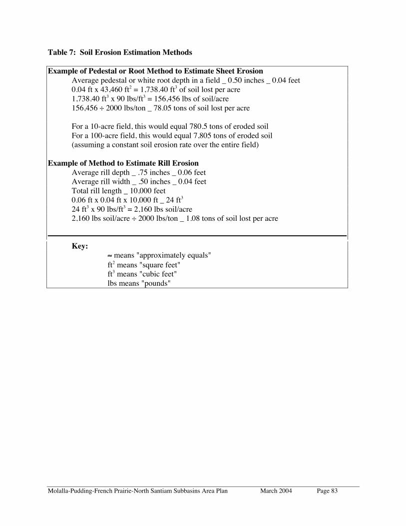
Molalla-Pudding-French Prairie-North Santiam Subbasins Area Plan March 2004 Page 83
Table 7: Soil Erosion Estimation Methods
Example of Pedestal or Root Method to Estimate Sheet ErosionAverage pedestal or white root depth in a field _ 0.50 inches _ 0.04 feet0.04 ft x 43,460 ft2 = 1,738.40 ft3 of soil lost per acre1,738.40 ft3 x 90 lbs/ft3 = 156,456 lbs of soil/acre156,456 ÷ 2000 lbs/ton _ 78.05 tons of soil lost per acre
For a 10-acre field, this would equal 780.5 tons of eroded soilFor a 100-acre field, this would equal 7,805 tons of eroded soil(assuming a constant soil erosion rate over the entire field)
Example of Method to Estimate Rill ErosionAverage rill depth _ .75 inches _ 0.06 feetAverage rill width _ .50 inches _ 0.04 feetTotal rill length _ 10,000 feet0.06 ft x 0.04 ft x 10,000 ft _ 24 ft3
24 ft3 x 90 lbs/ft3 = 2,160 lbs soil/acre2,160 lbs soil/acre ÷ 2000 lbs/ton _ 1.08 tons of soil lost per acre
Key:≈ means "approximately equals"ft2 means "square feet"ft3 means "cubic feet"lbs means "pounds"

Molalla-Pudding-French Prairie-North Santiam Subbasins Area Plan March 2004 Page 84
APPENDIX G: ORS 468B.025 AND 468B.050 – OREGON WATERPOLLUTION CONTROL LAW
486B.025 Prevention of Pollution(1) Except as provided in ORS 468B.740, no person shall:(a) Cause pollution of any waters of the state or place or cause to be placed any wastes in alocation where such wastes are likely to escape or be carried into the waters of the state byany means.(b) Discharge any wastes into the waters of the state if the discharge reduces the quality ofsuch waters below the water quality standards established by rule for such waters by theEnvironmental Quality Commission.(2) No person shall violate the conditions of any waste discharge permit issued under ORS468B.050.(3) Violation of subsection (1) or (2) of this section is a public nuisance.
ORS 468B.050 identifies the conditions when a permit is required. In agriculture, under staterules, these are referred to as Confined Animal Feeding Operations (CAFO) that confineanimals for more than 4 months per year and have a wastewater treatment facility. Theseoperations must have a permit, available from the Oregon Department of Agriculture.
468B.050 When Permit Required.(1) Except as provided in ORS 468B.053 or 468B.215, without first obtaining a permit fromthe Director of the Department of Environmental Quality, which permit shall specifyapplicable effluent limitations, no person shall:(a) Discharge any wastes into the waters of the state from any industrial or commercialestablishment or activity or any disposal system.(b) Construct, install, modify or operate any disposal system or part thereof or any extensionor addition thereto.(c) Increase in volume or strength any wastes in excess of the permissive discharges specifiedunder an existing permit.(d) Construct, install, operate or conduct any industrial, commercial, confined animal feedingoperation or other establishment or activity or any extension or modification thereof oraddition thereto, the operation or conduct of which would cause an increase in the dischargeof wastes into the waters of the state or which would otherwise alter the physical, chemical orbiological properties of any waters of the state in any manner not already lawfullyauthorized.(e) Construct or use any new outlet for the discharge of any wastes into the waters of thestate.(2) As used in this section, "confined animal feeding operation" has the meaning given inORS 468B.205. [Formerly 449.083 and then 468.740; 1997 c.286 s.6]

Molalla-Pudding-French Prairie-North Santiam Subbasins Area Plan March 2004 Page 85
APPENDIX H: WILLAMETTE RIVER BASIN WATER QUALITYSTUDY
Phase II
Non-Point Source Pollution in the Pudding River Subbasin of theWillamette River
By: E&S Environmental Chemistry, Inc. and Tetra Tech, Inc.June 27, 1995
Prepared For: Oregon Department of Environmental QualityWater Quality DivisionPortland, Oregon 97204
EXECUTIVE SUMMARYNonpoint sources (NPS) of pollution were identified as important contributors to waterquality degradation of the Willamette River in Phase I of the Willamette River Basin WaterQuality Study, which was completed in 1993. However, there was an acute scarcity of waterquality data within the basin, particularly during periods of high discharge, which typicallyaccount for the majority of NPS contributions to river systems. This data deficiencyprecluded rigorous quantification of NPS loads in specific components of the basin, and alsoprevented Willamette River Study scientists from assigning NPS contributions to the variousland uses that are prevalent within the basin. Phase II of the study was designed, in part, tocorrect this deficiency, and the results of the Phase II activities are described herein.
The NPS screening model that was applied in Phase I indicated that the Pudding RiverSubbasin contributed some of the greatest loads of total suspended solids (TSS), totalphosphorus (TP), and nitrogen (N) on an area-weighted basis in the Willamette River Basin.The Pudding River Subbasin has a high percentage of agricultural land use, and is currentlybeing studied by the U.S. Geological Survey as part of their NAWQA study of theWillamette River Basin. This sub-basin was therefore selected for intensive monitoring andNPS modeling in Phase II.
The principal objectives of the Phase II study were to characterize the effects on waterquality of specific land use types and land use intensities within the basin, and to use thisinformation to estimate NPS loads at the watershed and subbasin levels. Four sites withinthree watersheds were selected for study within the Pudding River system: one intensiveagricultural site on Zollner Creek; two low-intensity agricultural sites on Beaver Creek; and aforested site on Silver Creek. A fifth site was located downstream at the Pudding River atAurora to assess total loadings for the subbasin. Land use, soils, and hydrologic featureswere characterized at1:24, 000 scale in the three study watersheds and at a coarser scale (1:100,000) for thesubbasin.

Molalla-Pudding-French Prairie-North Santiam Subbasins Area Plan March 2004 Page 86
The water quality monitoring involved sampling water quality during baseflow andstormflow at five primary sites and over 25 supplemental sites. Each of the primary sites wassampled five times during baseflow and 10 to 14 times during each of five storms during theperiod from October 1994 to February 1995.
Results from the water quality monitoring showed that there was a strong relationship betweenwater quality and land use activities within the watersheds. Water quality in the forested sitewas generally excellent, although some elevated loads of TSS were measured, particularlyduring the first major storm in the fall. The water quality at the two low-intensity agriculturalsites on Beaver Creek showed higher concentrations of TSS, TP, nitrates (NO3), and major ionsthan the forested site. However, the predominant crop in the Beaver Creek watershed, grassseed, promotes adequate vegetable cover during high flow periods, resulting in only modestincreases in pollutant loads above those measured in the forested watershed. The greatestconcentrations and loads of NPS pollutants were generated by the high-intensity agriculturalwatershed. Concentrations of TSS, TP, NO3, NH4, major ions, and coliform bacteria in ZollnerCreek were all indicative of highly polluted water. Concentrations of TSS, TP, and totalKjeldahl nitrogen in Zollner increased with increasing runoff and generally reached maximumconcentrations just prior to maximum streamflow. Concentrations of NO3 increaseddramatically during the first storm and continued to increase as the stormflow receded,ultimately reaching a maximum of 27 mg/L (as NO3-N). Nitrate concentrations in ZollnerCreek were often well above the drinking water standard (10 mg/L). Nitrate in subsequentstorms was diluted by the surface runoff, but increased again during decreasing stream flow.The observed dynamics of NO3 in Zollner Creek indicated that most of the NO3 was derivedfrom accumulations in the deep soils (below the rooting zone) and was gradually flushed fromthe groundwater during hydrologic flows resulting from storm events. Water quality in thePudding River integrated inputs from the diverse watersheds in the subbasin resulting in runoffof intermediate quality.
The water quality data collected in this study were used to calibrate NPS models based on themodified universal soil loss equation (MUSLE) and spatial characteristics of the watershed(land use, soils, hydrography) using a geographic information system (GIS) framework. Thewater quality was modeled on a time step equivalent to the duration of a storm, typically about100 hours. Pollutant loads in most storms were well represented by the model. The greatestcalibration problem was associated with the first major storm in October in which measuredrunoff was far less than predicted runoff and the concentrations of some NPS pollutants wereunderpredicted. The former was caused by the inability of the model to reflect the extremelyhigh moisture deficit of the soils associated with the dry summer and early fall. Thecalibration process revealed that the intensity of agricultural practices was more important thangeneral land use categories in assigning pollutant loading coefficients. For example, thepollutant load associated with runoff from grass seed farms appeared to be substantially lessthan runoff from more intensively cultivated wheat and grain crops. However, grain crops andgrass seed fields appear similar on the aerial photographs typically used to characterize landuse. The NPS modeling in the agricultural watershed was difficult, in part because ofextensive modifications to surface and sub-surface hydrology associated with ditches and tiledrains.
Molalla-Pudding-French Prairie-North Santiam Subbasins Area Plan March 2004 Page 87
The modeling activity was conducted for the entire Pudding River subbasin using moregeneralized data inputs for land use, soils, and watershed features. The subbasin model resultsfor the Pudding River showed moderate agreement with measured values for individual storms.For all storms combined, however, the model results were in reasonable agreement, withmeasured values differing by 20%, 14%, and 46% for total suspended solids ,TP, and Nitrate(NO3) respectively.
The monitoring and modeling activities conducted within this study demonstrated that NPSpollution seriously impairs water quality in portions of the Willamette Valley. Among themore intensive agricultural watersheds, water quality problems include high-suspended solids,high nutrients, bacterial contamination, and a complete alteration of the major ion chemistry.Additionally, very high concentrations of NO3 measured in stormflow downstream fromintensive agriculture strongly suggest that aquifers in some areas of the valley are receivingexcessive loads of NO3 that may lead to groundwater pollution problems.