Embed Size (px)
Citation preview
2010 Major Thoroughfare and Freeway Plan CITY OF HOUSTON Amendment Request PLANNING AND DEVELOPMENT DEPARTMENT
PUBLIC HEARING REPORT
2010-01 Blodgett Street
APPLICANT: Walter P. Moore and Associates
KEY MAP: 533 D LAMBERT: 5455 JURISDICTION: Houston, Harris County DISTRICT/PRECINCT: Harris County, County Pct.1
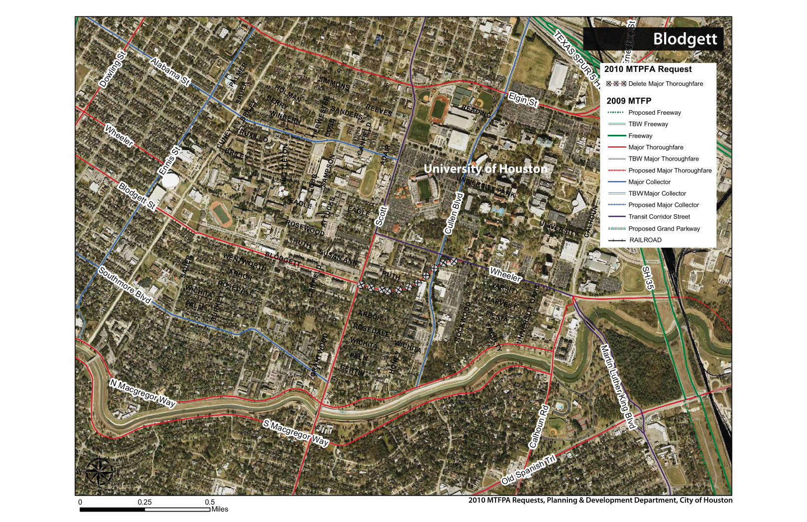
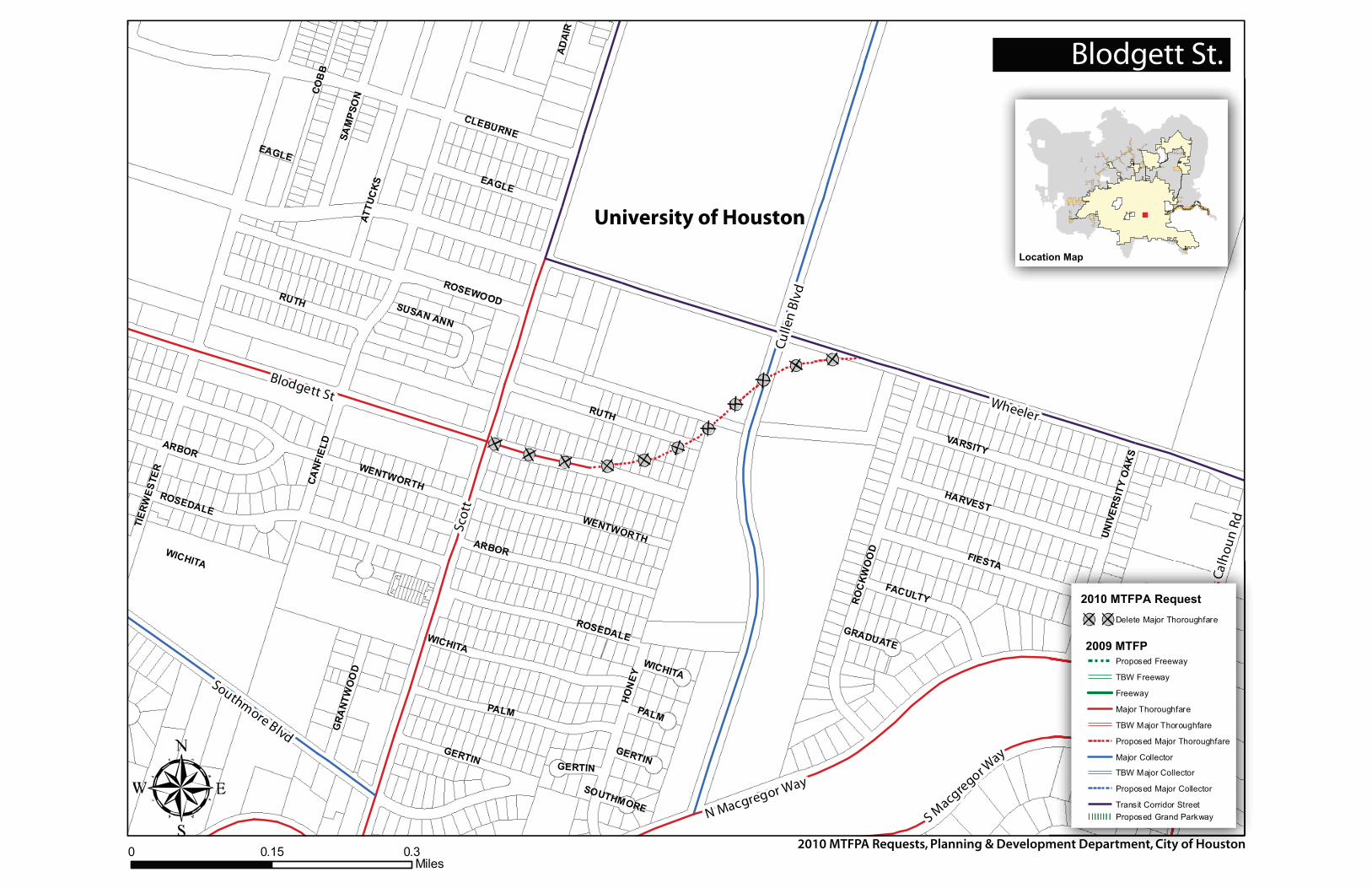
PROPOSAL: To delete the designated S-curve portion of Blodgett / Wheeler from Scott Street through the Cullen Boulevard intersection.
APPLICANT JUSTIFICATION:The University of Houston (UH) is requesting to delete the designated S-curve portion of Blodgett from Scott Street to Wheeler Street, through the Cullen Boulevard intersection. This segment of Blodgett was first included on the Major Thoroughfare and Freeway Plan (MTFP) in 1983. Over the past two years, UH has been working to implement their Transportation Management Plan (TMP) which has included coordination with City of Houston, Metro, TXDOT and H-GAC. Part of the TMP focused on improvements along Wheeler Avenue when Metro’s light rail along Southeast Corridor will be under construction. Wheeler between Scott Street and Calhoun is currently designated as a Transit Corridor Street. This classification for Wheeler was adopted in 2009 with the addition of Southeast (SE) Corridor on the MTFP.
Blodgett_2010.doc 7/30/2010http://www.houstontx.gov/planning/DevelopRegs/mobility/MTFP.html 1
2010 Major Thoroughfare and Freeway Plan CITY OF HOUSTON Amendment Request PLANNING AND DEVELOPMENT DEPARTMENT
PUBLIC HEARING REPORT
FP.html 2
FACTORS ASSESSED:
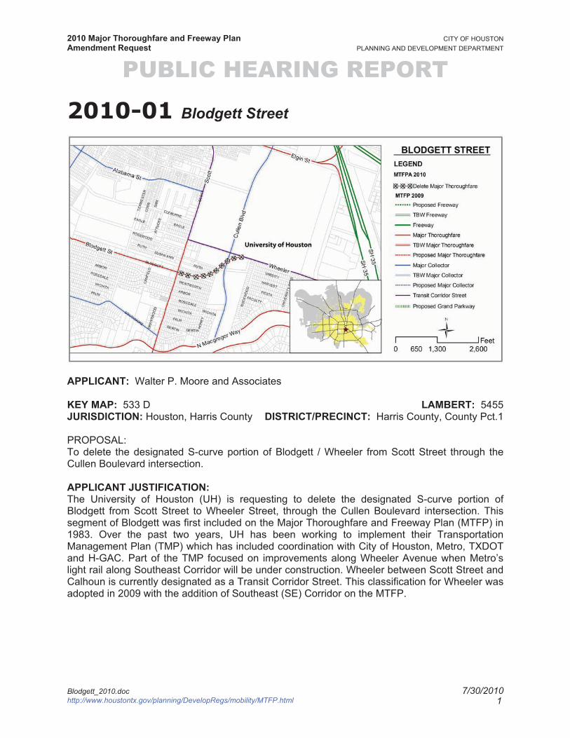
1. HistoryThe proposed extension of Blodgett St. east of Scott Street has been on the City of Houston’s MTFP since 1983. This alignment of Blodgett Street displayed as an S-curve, when completed, will extend Blodgett Street to Wheeler Street between Scott and Calhoun Rd. The extension is approximately 0.44 miles long. Blodgett Street, between Main Street and Scott Street, was first reflected on the MTFP in 1976 as a major thoroughfare. This section of Blodgett is classified as “T-4-80” on the MTFP Hierarchy Tables.
Wheeler Street had been a major thoroughfare from 1942 until 1976 when the portion of Wheeler between Dowling and Scott was deleted as a major thoroughfare and Blodgett Street was added as a major thoroughfare. In 1983, Wheeler between Scott and Cullen was de-classified and Blodgett was extended to Wheeler as a major thoroughfare. Cullen Street was designated as a major collector on the 1997 MTFP map. In 2009, Wheeler Street between Scott Street and Calhoun Rd. was designated as a transit corridor street.
1942 MTFP 1976 MTFP
1983 MTFP 1997 MTFP
NN
NN
Blodgett_2010.doc 7/30/2010http://www.houstontx.gov/planning/DevelopRegs/mobility/MT
2010 Major Thoroughfare and Freeway Plan CITY OF HOUSTON Amendment Request PLANNING AND DEVELOPMENT DEPARTMENT
PUBLIC HEARING REPORT
FP.html 3
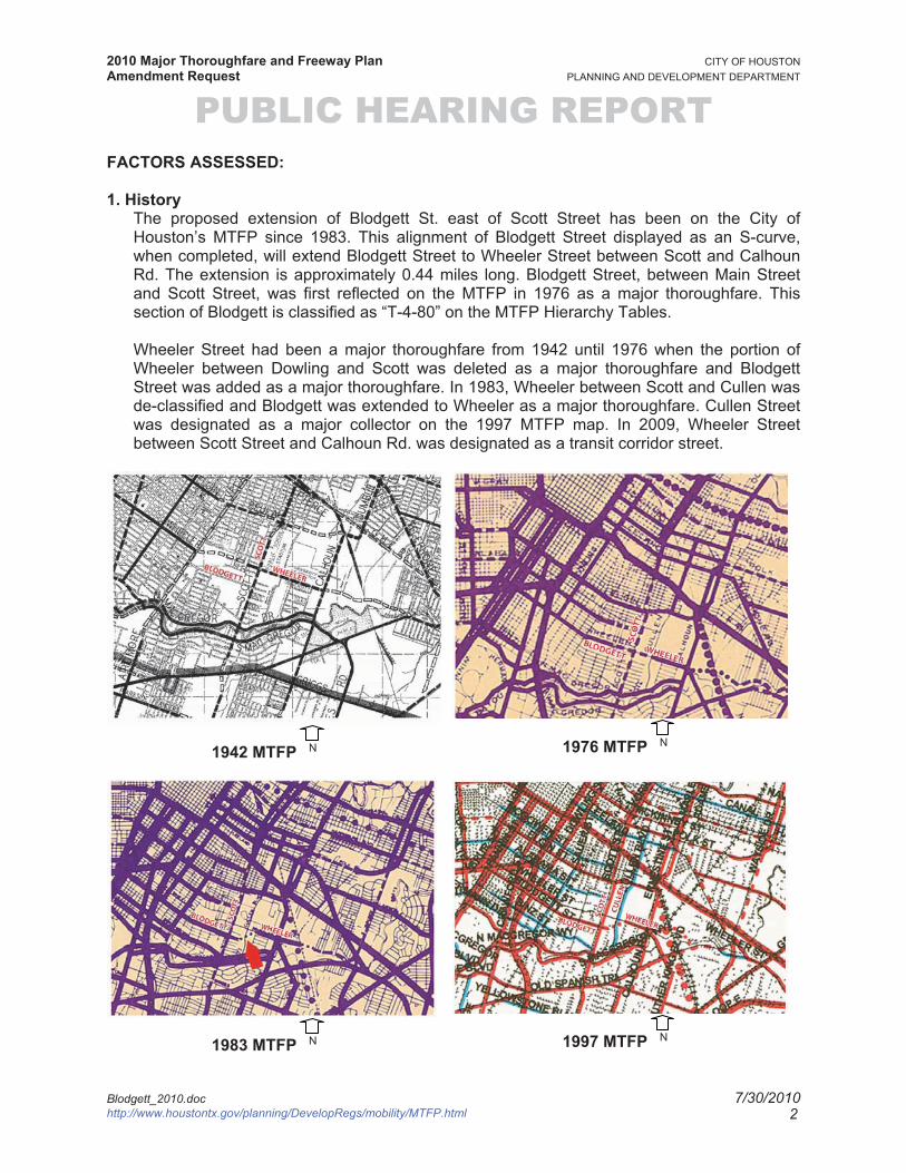
2009 MTFP N
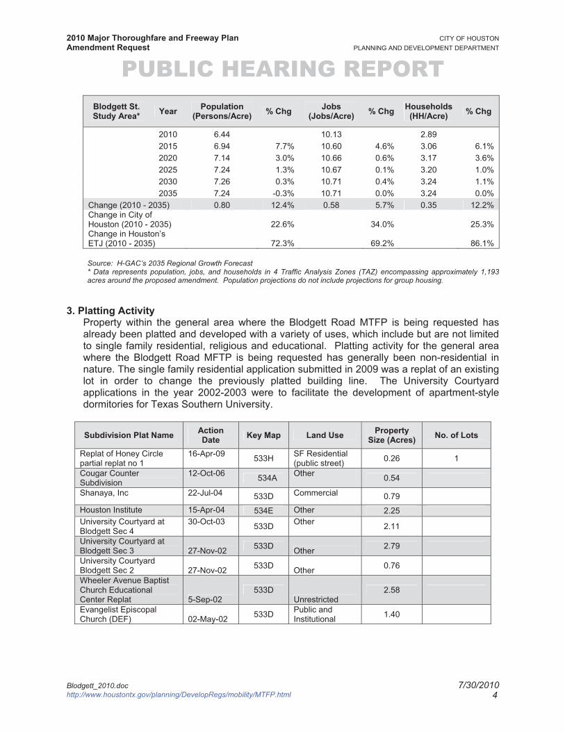
2. Population & Employment Projections Texas is one of the fastest growing states in the nation, and Harris County is the fastest growing county in the state1. Today, more than 2.2 million people live in the City of Houston and another 700,000 live in the City’s ETJ. Houston and its ETJ’s rich employment sector are home to more than 1.7 million jobs, making it the state’s most populous and robust economic center.
One of the greatest challenges to Houston’s mobility is that by 2035 more than 870,000 new residents are projected to live outside the City limits in the ETJ while the major thrust of employment growth is within the City limits. The distance between population and employment centers will result in more travel, greater travel time, and longer travel delays.
While the ETJ is growing, the City will also be taking in an additional 550,000 new residents. The most notable population growth occurs inside Loop 610. This growth reflects efforts to create a dense urban core through mixed-use development strategies.
The Houston-Galveston Area Council (H-GAC) projects that over the next 25 years (2010 – 2035), the population within the study area* will increase from 7,688 to 8,643 (956 persons), or 12.4%. The number of persons per acre is projected to increase from approximately 6.44 to approximately 7.24. During the same period, H-GAC estimates that the total jobs in the subject area will increase from 12,091 to 12,780 (690 jobs), or 5.7%. The number of jobs per acre is projected to increase from approximately 10.13 to 10.71.
Expressed in percentages, the subject area’s population growth is expected to be less than the City of Houston’s (12.4% versus 22.6%), and the area’s job growth is expected to be less than the City’s (5.7% versus 34.0%).
1. Eschbach, Karl. “Population Change in Texas” Texas State Data Center. 2008
http://txsdc.utsa.edu. Accessed May, 2009.
Blodgett_2010.doc 7/30/2010http://www.houstontx.gov/planning/DevelopRegs/mobility/MT
2010 Major Thoroughfare and Freeway Plan CITY OF HOUSTON Amendment Request PLANNING AND DEVELOPMENT DEPARTMENT
PUBLIC HEARING REPORT Blodgett St. Study Area* Year Population
(Persons/Acre) % Chg Jobs (Jobs/Acre) % Chg Households
(HH/Acre) % Chg
2010 6.44 10.13 2.892015 6.94 7.7% 10.60 4.6% 3.06 6.1%2020 7.14 3.0% 10.66 0.6% 3.17 3.6%2025 7.24 1.3% 10.67 0.1% 3.20 1.0%2030 7.26 0.3% 10.71 0.4% 3.24 1.1%2035 7.24 -0.3% 10.71 0.0% 3.24 0.0%
Change (2010 - 2035) 0.80 12.4% 0.58 5.7% 0.35 12.2%Change in City of Houston (2010 - 2035) 22.6% 34.0% 25.3% Change in Houston’s ETJ (2010 - 2035) 72.3% 69.2% 86.1%
Source: H-GAC’s 2035 Regional Growth Forecast * Data represents population, jobs, and households in 4 Traffic Analysis Zones (TAZ) encompassing approximately 1,193 acres around the proposed amendment. Population projections do not include projections for group housing.
3. Platting ActivityProperty within the general area where the Blodgett Road MTFP is being requested has already been platted and developed with a variety of uses, which include but are not limited to single family residential, religious and educational. Platting activity for the general area where the Blodgett Road MFTP is being requested has generally been non-residential in nature. The single family residential application submitted in 2009 was a replat of an existing lot in order to change the previously platted building line. The University Courtyard applications in the year 2002-2003 were to facilitate the development of apartment-style dormitories for Texas Southern University.
Subdivision Plat Name Action Date Key Map Land Use Property
Size (Acres) No. of Lots
Replat of Honey Circle partial replat no 1
16-Apr-09 533H SF Residential (public street) 0.26 1
Cougar Counter Subdivision
12-Oct-06 534A Other 0.54
Shanaya, Inc 22-Jul-04 533D Commercial 0.79Houston Institute 15-Apr-04 534E Other 2.25University Courtyard at Blodgett Sec 4
30-Oct-03 533D Other 2.11
University Courtyard at Blodgett Sec 3 27-Nov-02 533D Other 2.79
University Courtyard Blodgett Sec 2 27-Nov-02 533D Other 0.76
Wheeler Avenue Baptist Church Educational Center Replat 5-Sep-02
533D Unrestricted
2.58
Evangelist Episcopal Church (DEF) 02-May-02 533D Public and
Institutional 1.40
Blodgett_2010.doc 7/30/2010http://www.houstontx.gov/planning/DevelopRegs/mobility/MTFP.html 4
2010 Major Thoroughfare and Freeway Plan CITY OF HOUSTON Amendment Request PLANNING AND DEVELOPMENT DEPARTMENT
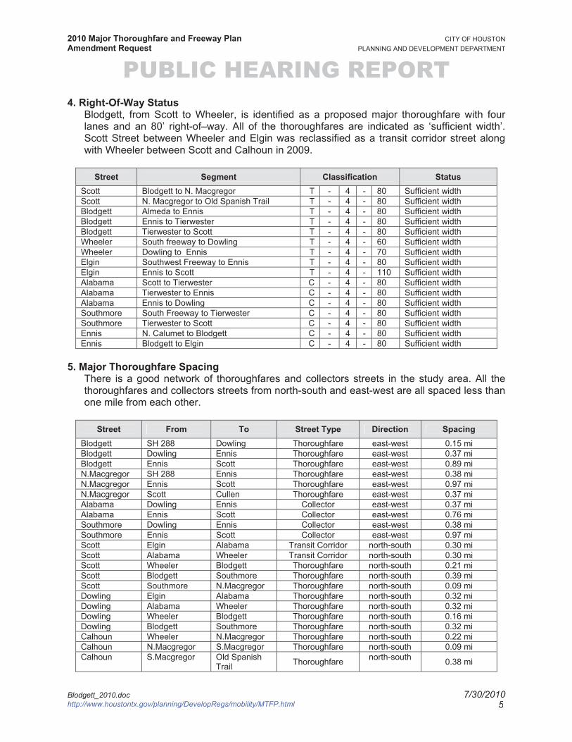
PUBLIC HEARING REPORT 4. Right-Of-Way Status
Blodgett, from Scott to Wheeler, is identified as a proposed major thoroughfare with four lanes and an 80’ right-of–way. All of the thoroughfares are indicated as ‘sufficient width’. Scott Street between Wheeler and Elgin was reclassified as a transit corridor street along with Wheeler between Scott and Calhoun in 2009.
Street Segment Classification StatusScott Blodgett to N. Macgregor T - 4 - 80 Sufficient width Scott N. Macgregor to Old Spanish Trail T - 4 - 80 Sufficient width Blodgett Almeda to Ennis T - 4 - 80 Sufficient width Blodgett Ennis to Tierwester T - 4 - 80 Sufficient width Blodgett Tierwester to Scott T - 4 - 80 Sufficient width Wheeler South freeway to Dowling T - 4 - 60 Sufficient width Wheeler Dowling to Ennis T - 4 - 70 Sufficient width Elgin Southwest Freeway to Ennis T - 4 - 80 Sufficient width Elgin Ennis to Scott T - 4 - 110 Sufficient width Alabama Scott to Tierwester C - 4 - 80 Sufficient width Alabama Tierwester to Ennis C - 4 - 80 Sufficient width Alabama Ennis to Dowling C - 4 - 80 Sufficient width Southmore South Freeway to Tierwester C - 4 - 80 Sufficient width Southmore Tierwester to Scott C - 4 - 80 Sufficient width Ennis N. Calumet to Blodgett C - 4 - 80 Sufficient width Ennis Blodgett to Elgin C - 4 - 80 Sufficient width
5. Major Thoroughfare SpacingThere is a good network of thoroughfares and collectors streets in the study area. All the thoroughfares and collectors streets from north-south and east-west are all spaced less than one mile from each other.
Street From To Street Type Direction Spacing Blodgett SH 288 Dowling Thoroughfare east-west 0.15 mi Blodgett Dowling Ennis Thoroughfare east-west 0.37 mi Blodgett Ennis Scott Thoroughfare east-west 0.89 mi N.Macgregor SH 288 Ennis Thoroughfare east-west 0.38 mi N.Macgregor Ennis Scott Thoroughfare east-west 0.97 mi N.Macgregor Scott Cullen Thoroughfare east-west 0.37 mi Alabama Dowling Ennis Collector east-west 0.37 mi Alabama Ennis Scott Collector east-west 0.76 mi Southmore Dowling Ennis Collector east-west 0.38 mi Southmore Ennis Scott Collector east-west 0.97 mi Scott Elgin Alabama Transit Corridor north-south 0.30 mi Scott Alabama Wheeler Transit Corridor north-south 0.30 mi Scott Wheeler Blodgett Thoroughfare north-south 0.21 miScott Blodgett Southmore Thoroughfare north-south 0.39 miScott Southmore N.Macgregor Thoroughfare north-south 0.09 mi Dowling Elgin Alabama Thoroughfare north-south 0.32 mi Dowling Alabama Wheeler Thoroughfare north-south 0.32 mi Dowling Wheeler Blodgett Thoroughfare north-south 0.16 mi Dowling Blodgett Southmore Thoroughfare north-south 0.32 mi Calhoun Wheeler N.Macgregor Thoroughfare north-south 0.22 mi Calhoun N.Macgregor S.Macgregor Thoroughfare north-south 0.09 mi Calhoun S.Macgregor Old Spanish
Trail Thoroughfare north-south 0.38 mi
Blodgett_2010.doc 7/30/2010http://www.houstontx.gov/planning/DevelopRegs/mobility/MTFP.html 5
2010 Major Thoroughfare and Freeway Plan CITY OF HOUSTON Amendment Request PLANNING AND DEVELOPMENT DEPARTMENT
PUBLIC HEARING REPORT Street From To Street Type Direction Spacing
Ennis Elgin Alabama Collector north-south 0.32 mi Ennis Alabama Wheeler Collector north-south 0.32 mi Ennis Wheeler Blodgett Collector north-south 0.16 miEnnis Blodgett Southmore Collector north-south 0.32 mi
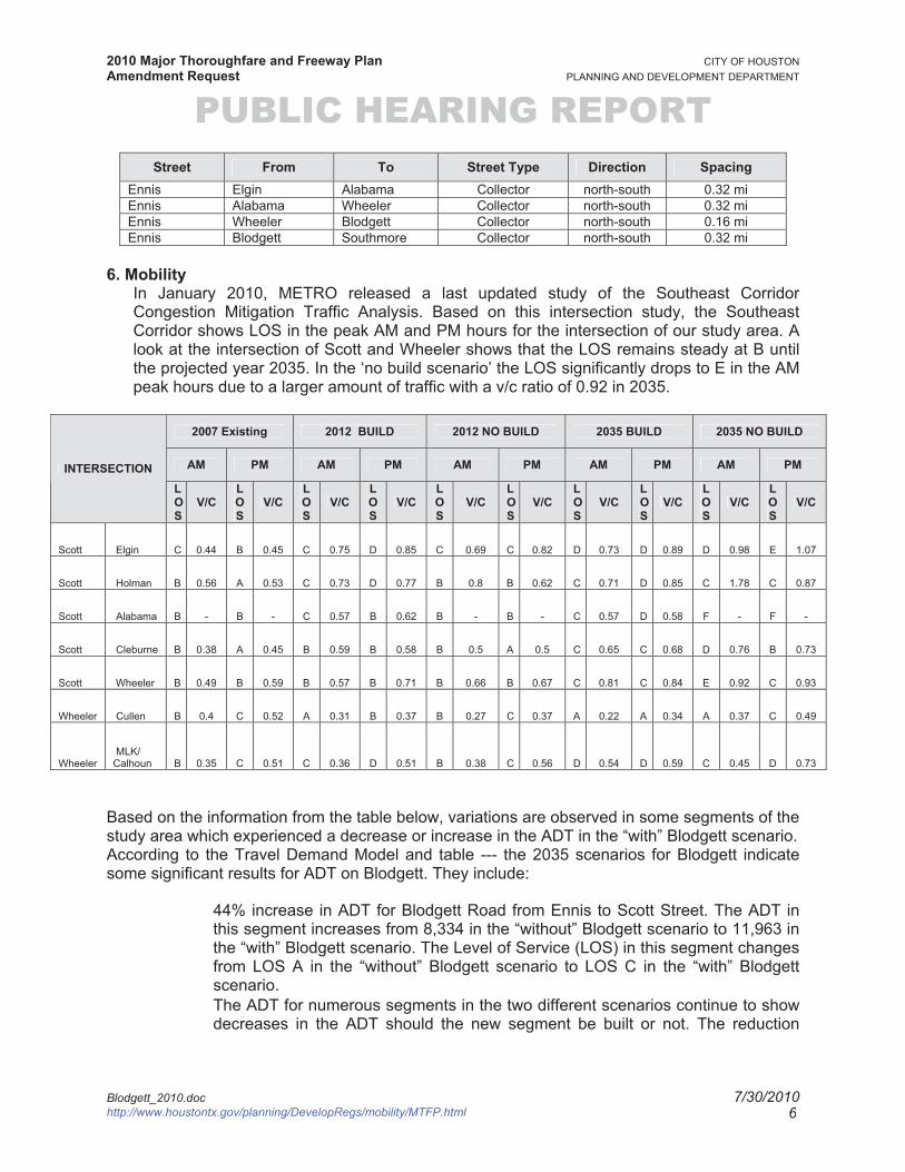
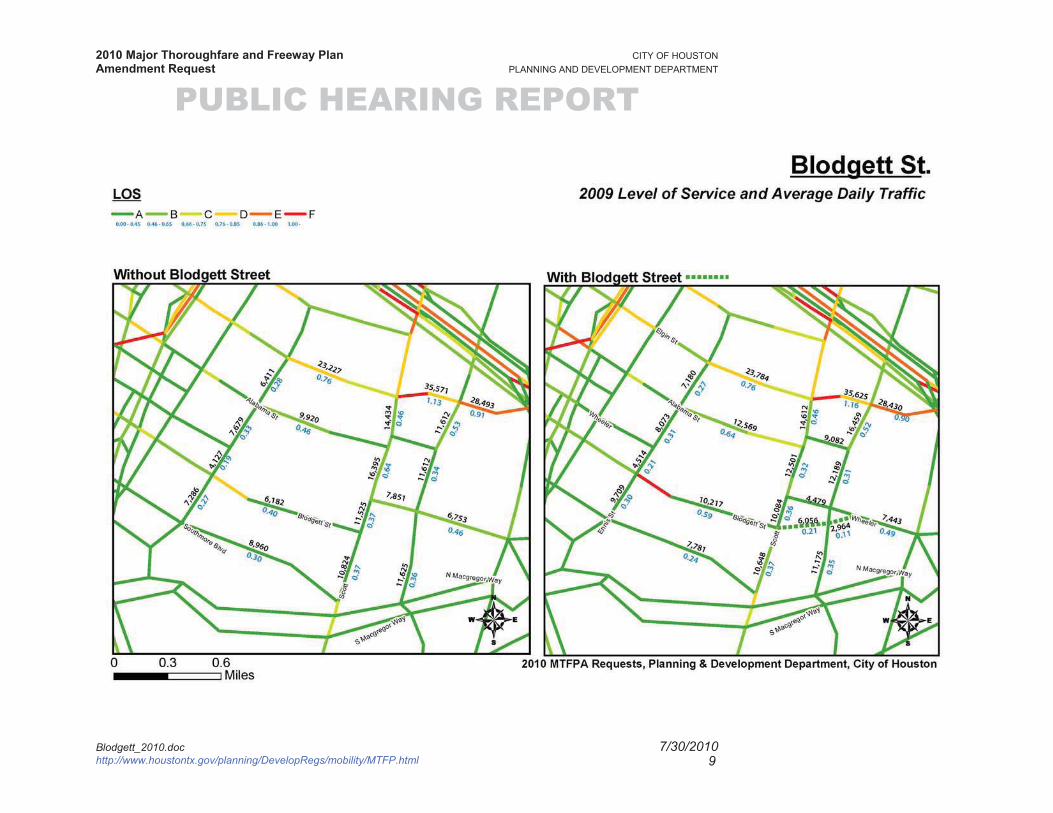
6. MobilityIn January 2010, METRO released a last updated study of the Southeast Corridor Congestion Mitigation Traffic Analysis. Based on this intersection study, the Southeast Corridor shows LOS in the peak AM and PM hours for the intersection of our study area. A look at the intersection of Scott and Wheeler shows that the LOS remains steady at B until the projected year 2035. In the ‘no build scenario’ the LOS significantly drops to E in the AM peak hours due to a larger amount of traffic with a v/c ratio of 0.92 in 2035.
2007 Existing 2012 BUILD 2012 NO BUILD 2035 BUILD 2035 NO BUILD
AM PM AM PM AM PM AM PM AM PMINTERSECTION LOS
V/CLOS
V/CLOS
V/CLOS
V/CLOS
V/CLOS
V/CLOS
V/CLOS
V/CLOS
V/CLOS
V/C
Scott Elgin C 0.44 B 0.45 C 0.75 D 0.85 C 0.69 C 0.82 D 0.73 D 0.89 D 0.98 E 1.07
Scott Holman B 0.56 A 0.53 C 0.73 D 0.77 B 0.8 B 0.62 C 0.71 D 0.85 C 1.78 C 0.87
Scott Alabama B - B - C 0.57 B 0.62 B - B - C 0.57 D 0.58 F - F -
Scott Cleburne B 0.38 A 0.45 B 0.59 B 0.58 B 0.5 A 0.5 C 0.65 C 0.68 D 0.76 B 0.73
Scott Wheeler B 0.49 B 0.59 B 0.57 B 0.71 B 0.66 B 0.67 C 0.81 C 0.84 E 0.92 C 0.93
Wheeler Cullen B 0.4 C 0.52 A 0.31 B 0.37 B 0.27 C 0.37 A 0.22 A 0.34 A 0.37 C 0.49
Wheeler MLK/ Calhoun B 0.35 C 0.51 C 0.36 D 0.51 B 0.38 C 0.56 D 0.54 D 0.59 C 0.45 D 0.73
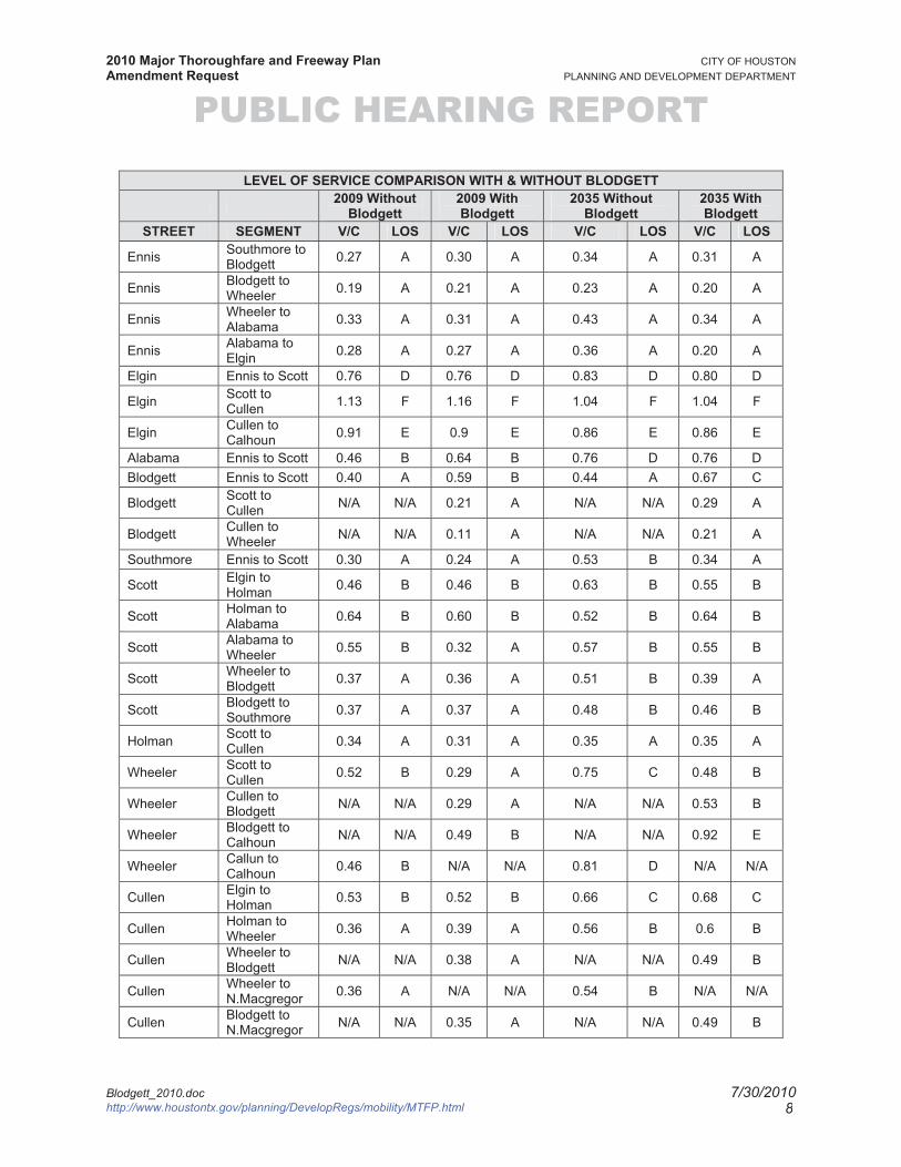
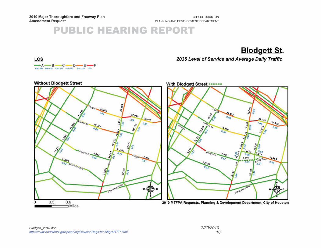
Based on the information from the table below, variations are observed in some segments of the study area which experienced a decrease or increase in the ADT in the “with” Blodgett scenario. According to the Travel Demand Model and table --- the 2035 scenarios for Blodgett indicate some significant results for ADT on Blodgett. They include:
44% increase in ADT for Blodgett Road from Ennis to Scott Street. The ADT in this segment increases from 8,334 in the “without” Blodgett scenario to 11,963 in the “with” Blodgett scenario. The Level of Service (LOS) in this segment changes from LOS A in the “without” Blodgett scenario to LOS C in the “with” Blodgett scenario.
The ADT for numerous segments in the two different scenarios continue to show decreases in the ADT should the new segment be built or not. The reduction
Blodgett_2010.doc 7/30/2010http://www.houstontx.gov/planning/DevelopRegs/mobility/MTFP.html 6
2010 Major Thoroughfare and Freeway Plan CITY OF HOUSTON Amendment Request PLANNING AND DEVELOPMENT DEPARTMENT
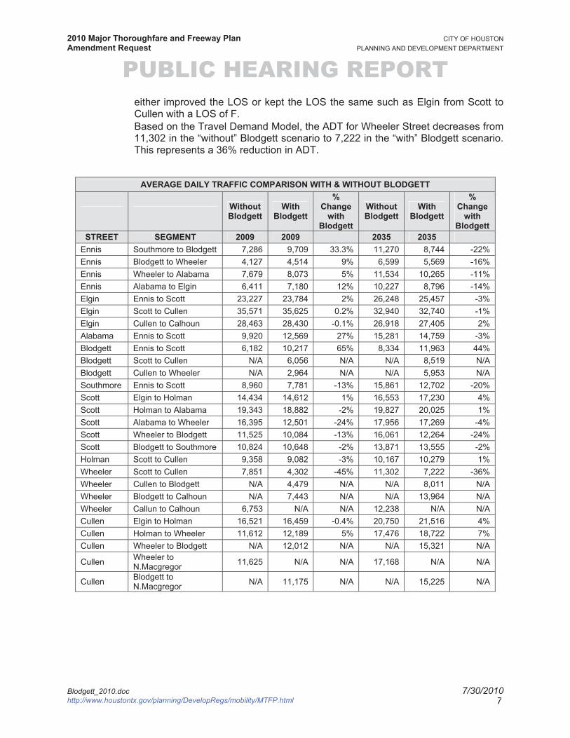
PUBLIC HEARING REPORT either improved the LOS or kept the LOS the same such as Elgin from Scott to Cullen with a LOS of F.
Based on the Travel Demand Model, the ADT for Wheeler Street decreases from 11,302 in the “without” Blodgett scenario to 7,222 in the “with” Blodgett scenario. This represents a 36% reduction in ADT.
AVERAGE DAILY TRAFFIC COMPARISON WITH & WITHOUT BLODGETT
Without Blodgett
WithBlodgett
%Change
with Blodgett
Without Blodgett
WithBlodgett
%Change
with Blodgett
STREET SEGMENT 2009 2009 2035 2035 Ennis Southmore to Blodgett 7,286 9,709 33.3% 11,270 8,744 -22%Ennis Blodgett to Wheeler 4,127 4,514 9% 6,599 5,569 -16%Ennis Wheeler to Alabama 7,679 8,073 5% 11,534 10,265 -11%Ennis Alabama to Elgin 6,411 7,180 12% 10,227 8,796 -14%Elgin Ennis to Scott 23,227 23,784 2% 26,248 25,457 -3%Elgin Scott to Cullen 35,571 35,625 0.2% 32,940 32,740 -1%Elgin Cullen to Calhoun 28,463 28,430 -0.1% 26,918 27,405 2%Alabama Ennis to Scott 9,920 12,569 27% 15,281 14,759 -3%Blodgett Ennis to Scott 6,182 10,217 65% 8,334 11,963 44%Blodgett Scott to Cullen N/A 6,056 N/A N/A 8,519 N/ABlodgett Cullen to Wheeler N/A 2,964 N/A N/A 5,953 N/ASouthmore Ennis to Scott 8,960 7,781 -13% 15,861 12,702 -20%Scott Elgin to Holman 14,434 14,612 1% 16,553 17,230 4%Scott Holman to Alabama 19,343 18,882 -2% 19,827 20,025 1%Scott Alabama to Wheeler 16,395 12,501 -24% 17,956 17,269 -4%Scott Wheeler to Blodgett 11,525 10,084 -13% 16,061 12,264 -24%Scott Blodgett to Southmore 10,824 10,648 -2% 13,871 13,555 -2%Holman Scott to Cullen 9,358 9,082 -3% 10,167 10,279 1%Wheeler Scott to Cullen 7,851 4,302 -45% 11,302 7,222 -36%Wheeler Cullen to Blodgett N/A 4,479 N/A N/A 8,011 N/AWheeler Blodgett to Calhoun N/A 7,443 N/A N/A 13,964 N/AWheeler Callun to Calhoun 6,753 N/A N/A 12,238 N/A N/ACullen Elgin to Holman 16,521 16,459 -0.4% 20,750 21,516 4%Cullen Holman to Wheeler 11,612 12,189 5% 17,476 18,722 7%Cullen Wheeler to Blodgett N/A 12,012 N/A N/A 15,321 N/A
Cullen Wheeler to N.Macgregor 11,625 N/A N/A 17,168 N/A N/A
Cullen Blodgett to N.Macgregor N/A 11,175 N/A N/A 15,225 N/A
Blodgett_2010.doc 7/30/2010http://www.houstontx.gov/planning/DevelopRegs/mobility/MTFP.html 7
2010 Major Thoroughfare and Freeway Plan CITY OF HOUSTON Amendment Request PLANNING AND DEVELOPMENT DEPARTMENT
PUBLIC HEARING REPORT
Blodgett_2010.doc 7/30/2010http://www.houstontx.gov/planning/DevelopRegs/mobility/MTFP.html 8
LEVEL OF SERVICE COMPARISON WITH & WITHOUT BLODGETT 2009 Without
Blodgett 2009 With Blodgett
2035 Without Blodgett
2035 With Blodgett
STREET SEGMENT V/C LOS V/C LOS V/C LOS V/C LOS
Ennis Southmore to Blodgett 0.27 A 0.30 A 0.34 A 0.31 A
Ennis Blodgett to Wheeler 0.19 A 0.21 A 0.23 A 0.20 A
Ennis Wheeler to Alabama 0.33 A 0.31 A 0.43 A 0.34 A
Ennis Alabama to Elgin 0.28 A 0.27 A 0.36 A 0.20 A
Elgin Ennis to Scott 0.76 D 0.76 D 0.83 D 0.80 D
Elgin Scott to Cullen 1.13 F 1.16 F 1.04 F 1.04 F
Elgin Cullen to Calhoun 0.91 E 0.9 E 0.86 E 0.86 E
Alabama Ennis to Scott 0.46 B 0.64 B 0.76 D 0.76 DBlodgett Ennis to Scott 0.40 A 0.59 B 0.44 A 0.67 C
Blodgett Scott to Cullen N/A N/A 0.21 A N/A N/A 0.29 A
Blodgett Cullen to Wheeler N/A N/A 0.11 A N/A N/A 0.21 A
Southmore Ennis to Scott 0.30 A 0.24 A 0.53 B 0.34 A
Scott Elgin to Holman 0.46 B 0.46 B 0.63 B 0.55 B
Scott Holman to Alabama 0.64 B 0.60 B 0.52 B 0.64 B
Scott Alabama to Wheeler 0.55 B 0.32 A 0.57 B 0.55 B
Scott Wheeler to Blodgett 0.37 A 0.36 A 0.51 B 0.39 A
Scott Blodgett to Southmore 0.37 A 0.37 A 0.48 B 0.46 B
Holman Scott to Cullen 0.34 A 0.31 A 0.35 A 0.35 A
Wheeler Scott to Cullen 0.52 B 0.29 A 0.75 C 0.48 B
Wheeler Cullen to Blodgett N/A N/A 0.29 A N/A N/A 0.53 B
Wheeler Blodgett to Calhoun N/A N/A 0.49 B N/A N/A 0.92 E
Wheeler Callun to Calhoun 0.46 B N/A N/A 0.81 D N/A N/A
Cullen Elgin to Holman 0.53 B 0.52 B 0.66 C 0.68 C
Cullen Holman to Wheeler 0.36 A 0.39 A 0.56 B 0.6 B
Cullen Wheeler to Blodgett N/A N/A 0.38 A N/A N/A 0.49 B
Cullen Wheeler to N.Macgregor 0.36 A N/A N/A 0.54 B N/A N/A
Cullen Blodgett to N.Macgregor N/A N/A 0.35 A N/A N/A 0.49 B
2010 Major Thoroughfare and Freeway Plan CITY OF HOUSTON Amendment Request PLANNING AND DEVELOPMENT DEPARTMENT
PUBLIC HEARING REPORT
Blodgett_2010.doc 7/30/2010http://www.houstontx.gov/planning/DevelopRegs/mobility/MTFP.html 9
2010 Major Thoroughfare and Freeway Plan CITY OF HOUSTON Amendment Request PLANNING AND DEVELOPMENT DEPARTMENT
PUBLIC HEARING REPORT
Blodgett_2010.doc 7/30/2010http://www.houstontx.gov/planning/DevelopRegs/mobility/MTFP.html 10
Scot
t
Elgin St
SH35
Enni
sSt
Cul
len
Blvd
Blodgett St
S IH 45
Alabama St
S Macgregor Way
N Macgregor Way
Wheeler
Old Spanish Trl
Southmore Blvd
Cal
houn
Rd
Dowl
ing
St
TEXASSPUR
5 HWY
Erne
stin
eS
t
Martin
Luther KingBlvd
SH35
Wheeler
S IH 45
HOLMAN
BLODGETT
TIER
WES
TER
ROSEDALE
REEVES
WENTWORTH
BU
RK
ETT
CO
BB
SIMMONS
CA
LHO
UN
CA
NFI
ELD
UNIVERSITY
PALM
RUTH
SAM
PSO
N
FIESTA
HO
NE
Y
RO
CK
WO
OD
ARBOR
BERRY
VARSITY
WICHITA
AD
AIR
HARVEST
SAU
ER
EAGLE
GERTIN
ATTU
CK
S
FACULTY
SANDERS
CUNE
Y
NET
TLET
ON
UN
IVER
SITY
OA
KS
BRILEY
UNIVERSITY PARK
GR
AN
TWO
OD
READING
SUSAN ANN
PALM
ER
TRUXILLO
EAGLE
BRIL
EY
WICHITA
WICHITA
SAU
ER
ARBOR
CA
NFI
ELD
WINBERN
CO
BB
PALM
ROSEDALE
RUTH
ROSEWOOD
5.00 0.25Miles
estin
eS
Blodgett
2010 MTPFA RequestDelete Major Thoroughfare
Proposed Freeway
TBW Freeway
Freeway
Major Thoroughfare
TBW Major Thoroughfare
Proposed Major Thoroughfare
Major Collector
TBWMajor Collector
Proposed Major Collector
Transit Corridor Street
Proposed Grand Parkway
RAILROAD
2009 MTFP
2010 MTFPA Requests, Planning & Development Department, City of Houston
dd
UNNNNNIVERSITY PAPP RK
University of Houston
Scot
t
Culle
nBl
vd
Wheeler
Blodgett St
N Macgregor Way
Calh
oun
Rd
Southmore Blvd
S Macgregor Way
TIER
WES
TER WENTWORTHCANF
IELD
CLEBURNE
COB
B
PALM
RUTH
FIESTA
ROC
KWO
ODARBOR
HON
EY
VARSITY
ROSEWOOD
WICHITA
HARVEST
EAGLE
SAM
PSO
N
ROSEDALE
GERTIN
ATTU
CKS
FACULTY
UNIV
ERSI
TYO
AKS
GRA
NTW
OO
D
SUSAN ANN
ADAI
R
GRADUATE
WICHITA
PALM
GERTIN
EAGLE
SOUTHMORE
WICHITA
RUTH
ARBOR
ROSEDALE
GERTIN
WENTWORTH
3.00 0.15Miles
CCalh
2010 MTFPA RequestDelete Major Thoroughfare
Proposed Freeway
TBW Freeway
Freeway
Major Thoroughfare
TBW Major Thoroughfare
Proposed Major Thoroughfare
Major Collector
TBW Major Collector
Proposed Major Collector
Transit Corridor StreetProposed Grand Parkway
2009 MTFP
Blodgett St.
2010 MTFPA Requests, Planning & Development Department, City of Houston
Location Map
University of Houston