Embed Size (px)
Citation preview

l
MAJOR THOROUGHFARE PLAN
l EI izabethton, Tennessee
June , 1987

Prepared for
THE ELIZABETHTON MUNICIPAL PLANNING COMMISSION
David Ornduff, Manuel M. Bandarra, Secretary John Fleming, Mayor Bill Cooper
Chairman Thomas M. Hord, Haynes Elliott Dempsey Shell
Prepared by
City Manager
DEPARTMENT OF ECONOMIC AND COMMUNITY DEVELOPMENT Local Planning Off ice 207 North Boone Street Johnson City, TN 37601
June 1987

CONTENTS
INTRODUCTION 1
PiAJOR THOROUGHFARE IMPROVEMENTS 3
Intersection of 67 and 321 3
Parkway Boulevard and Field Road Intersection 6
Create East-West Collector Route Via Southside Road, Watauga Avenue, Cedar Street, Florence Street, First Street and Arney Street 6
Connect Old Stoney Creek Road to Bristol Highway and Watauga Road · 10
Extend Sycamore Street to Connect with 19-E Bypass 10
UPDATE OF THOROUGHFARE PLAN 15
MARGINAL ACCESS STREET FOR WEST ELK AVENUE 18
SUMMARY 23

LIST OF· ILLUSTRATIONS
1. 1970 MAJOR THOROUGHFARE PLAN
2. 1987 MAJOR THOROUGHFARE PLAN
3. WEST ELK AVENUE MARGINAL ACCESS PLAN
LIST OF FIGURES
1. AERIAL VIEW OF PROPOSED INTERSECTION OF WEST ''G''
16
17
19
STREET AND HIGHWAY 67 4
2. WEST "G" STREET FACING WEST SHOWING ROUTE OF WEST "G" STREET TO INTERSECTION OF HIGHWAY 67 5
3. HIGHWAY 67 FACING EAST TO WEST "G" STREET 5
4. INTERSECTION OF PARKWAY BOULEVARD AND FIELD ROAD FACING NORTH 7
5. SOUTHSIDE ROAD BETWEEN GAP CREEK ROAD AND PARKWAY BOULEVARD 8
6. HILL AT THE INTERSECTION OF SOUTHSIDE ROAD AND SOUTH HILLS HOUSING DEVELOPMENT 8
7. WATAUGA AVENUE FACING SOUTH NEAR ITS INTERSECTION WITH SOUTHSIDE ROAD 9
8. FLORENCE STREET BETWEEN JOHNSON AND CEDAR 9
9. FLORENCE STREET FACING EAST AT THE INTERSECTION OF JOHNSON AVENUE AND FIRST AVENUE 11
10. SAME AS FIGURE 9 EXCEPT FACING WEST FROM FIRST AVENUE 11
11 . . CURVE ON ARNEY STREET
12. THIS ILLUSTRATION SHOWS THE NEED FOR CONSTRUCTION OF A SHORT ROAD FROM INTERSECTION EASTWARD TO OLD
12
STONEY CREEK ROAD 12

LIST OF FIGURES (CONTINUED)
13. 19E/321 BYPASS LOOKING NORTH TO SYCAMORE STREET 14
14. SYCAMORE STREET LOOKING SOUTH TO 19E/321 BYPASS SHOWING PROPOSED ROUTE OF SYCAMORE STREET EXTENSION 14
15. McARTHUR STREET AS IT INTERSECTS WITH RAILROAD STREET AND WEST ELK AVENUE 22
16. INTERSECTION OF HUDSON DRIVE AND WEST ELK AVENUE 22

INTRODUCTION
In 1970, the Tennessee Department of Transportation working in
conjunction with the Elizabethton Planning Commission prepared a
Major Thoroughfare Plan for the city. In the seventeen years since
publication of this plan, there has been many changes in the traffic
patterns within the city. The new State Route 37 (State Line Road)
has long been completed. The portion of the new highway to Johnson
City that is located in Elizabethton is completed and the remainder
of the project is well underway. Work is also rapidly progressing
on the new highway to Bristol. Other significant changes include
the closing of the western end of ''G'' Street and a major shift of
commercial activity from downtown to West Elk Avenue and Broad
Street. In 1970 traffic counts on West Elk Avenue were 14,000 and
26,250 in 1986. Broad Street figures for 1970 were 12,500 and
24,580 in 1986. Traffic volumes on these two streets have nearly
doubled. These figures emphasize the need to update the city's major
thoroughfare plan. Elizabethton streets have been classified
according to the function they perform. The streets were defined
and classified in accordance with the following definition:
Arterial - Facilities which serve the major movement of
traffic within and throughout the city. While the major
function of arterials is to move traffic, a secondary
service is land access.

Collector - Facilities which serve the internal traffic
movement within an area of the city, such as subdivision,
anJ. connecL Lhis area with Lhe arLerial system. They Jo
not handle long through trips and, of necessity, are not
continuous for any length.
Local - Facilities which are designed to be used primarily
for direct access to abutting property. A large percent
age of street mileage is comprised of local streets, but
these carry a small portion, in relation to their length,
of the vehicle miles traveled .
There are approximately seventy miles of streets in the
existing street system within Elizabethton. Arterials account for
nine miles or nearly 13 percent of the total street mileage . Col
lectors account for six miles or almost 9 percent of the total
street mileage . Local streets which make up the majority of the
street system, account for the remaining 55 miles or 78 percent
of the total street system, The major thoroughfare plan will deal
with the city's arterial and collector streets and ways to improve
major traffic flows.
This plan is presented in three sections. The first section
is titled Major Thoroughfare Improvements, the second section section
is Update of Thoroughfare Plan, and the third section is Marginal
Access Street for West Elk Avenue.
- 2 -

MAJOR THOROUGHFARE IMPROVEMENTS
There are five proposed improvements to the thoroughfare system
that would improve traffic circulation within Elizabethton. Each of
these six improvements will · be discussed in the following paragraphs.
Intersection of 67 and 321
In 1986 the first section of the new four lane Highway 67 to
Johnson City was completed. This section involved the closing of
West "G" Street, a partial relocation of the Golf Course and the
opening of a new portion of Sabine Street to provide a cross over
from West "G" Street to West Elk Avenue. Since these changes were
made, there has been widespread dissatisfaction with this intersection.
It is difficult to enter and exit Sabine Street at West Elk Avenue
and consequently a significant portion of the traffic that previously
traveled West "G'' Street and Gap Creek Road has been rerouted through
West Elk Avenue and Broad Street which already have excessive amounts
of traffic. A proposed solution to this problem would be to close
the new extension of Sabine and construct a new crossover from West
"G" Street to . the intersection of 67 and 32L This would allow
traffic from West "G" Street and Gap Creek to enter West Elk Avenue
at the traffic light. This proposal would re-open West ''G" Street
as a major east-west arterial street and would encourage use of Gap
Creek Road for southbound traffic.
- 3 -

Figure 1 . Aerial view of proposed intersection of West "G" Street and Highway 67.
- 4 -

Figure 2
Figure 3
This picture is taken from West G Street facing west showing rouLe of West G Street to intersection of Highway 67
This picture is taken from Highway 67 facing east to West G Street
5
Parkway Boulevard and Field Road Intersection
This project would involve removing the stop signs from Parkway
Boulevard at the intersection and placing the stop signs on Field
Road. This would allow Parkway Boulevard to become the through
street and would expedite traffic going north on Parkway Boulevard
to West "G" Street and West Elk Avenue. Parkway Boulevard should be
widened on the northeastern side of this intersection to eliminate
a jog in the street.
Create East-West Collector Route Via Southside Road, Watauga Avenue,
Cedar Street, Florence Street, First Street and Arney Street
At present it is possible to travel from Gap Creek Road through
Southside to the old State Line Road, however, the route is difficult.
The following list of improvements are proposed to improve traffic
flow in this area primarily for the benefit of the people residing in
these areas.
1. The section 0£ Southside Road from Gap Creek Road to
Parkway Boulevard should be widened and some of the
worst curves should be straightened.
2. Two hills at the intersection of Southside Road and
Watauga Avenue should be lowered to improve visability.
3. Florence Street should be widened and made a through
street to First Avenue. This would require removing
- 6 -

Figure 4
~- -------~-----.---..-,.--------~--------~
This picture shows the intersection of Parkway Boulevard and Field Road facing north. The intersection should be changed to make Parkway a through street and the telephone pole at the center of this picture should be setback and the street should be widened to eliminate the street jog on Parkway Boulevard.
- 7 -

Figure 5
Figure 6
Southside Road between Gap Creek Road and Parkway Boulevard needs widened and straightened
This hill at the intersection of Southside Road and South Hills Housing Development needs to be lowered to improve visibility
- 8 -

Figure 7
Figure 8
This picture shows Watauga Avenue intersection with Southside Road. lowered to improve visibility .
facing south near its This hill needs to be
Florence Street between Johnson and Cedar should be widened and should be made a through street.
- 9 -
signs at Second Street and Johnson Avenue (should
Johnson Avenue ever be extended to the proposed
southern bypass, this intersection could be re
evaluated). There is a street jog located at this
intersection where Florence Avenue and First Street
enter Johnson Avenue at the Herman Robinson Vocational
School. This jog should be eliminated.
4. Straighten road at curve on Arney Street.
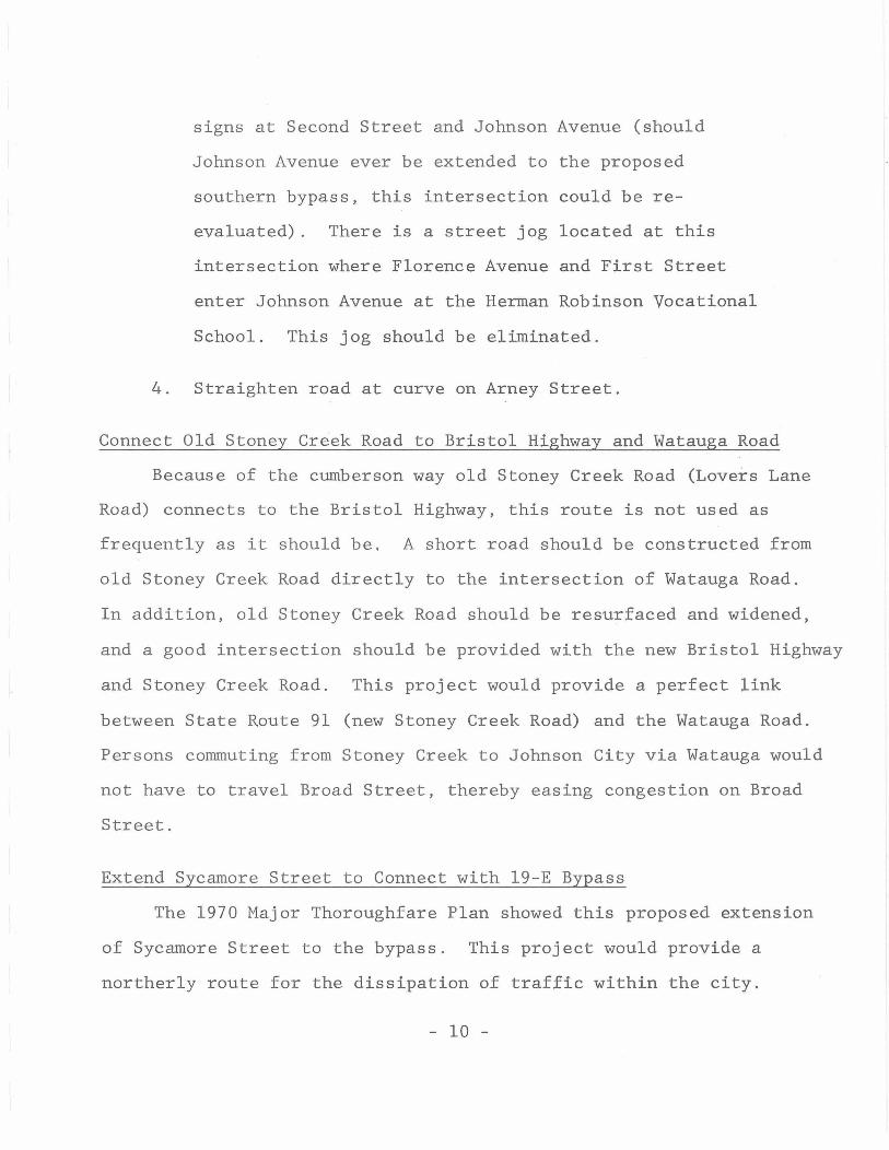
Connect Old Stoney Creek Road to Bristol Highway and Watauga Road
Because of the cumberson way old Stoney Creek Road (Lovers Lane
Road) connects to the Bristol Highway, this route is not used as
frequently as it should be. A short road should be constructed from
old Stoney Creek Road directly to the intersection of Watauga Road.
In addition, old Stoney Creek Road should be resurfaced and widened,
and a good intersection should be provided with the new Bristol Highway
and Stoney Creek Road. This project would provide a perfect link
between State Route 91 (new Stoney Creek Road) and the Watauga Road.
Persons conunuting from Stoney Creek to Johnson City via Watauga would
not have to travel Broad Street, thereby easing congestion on Broad
Street.
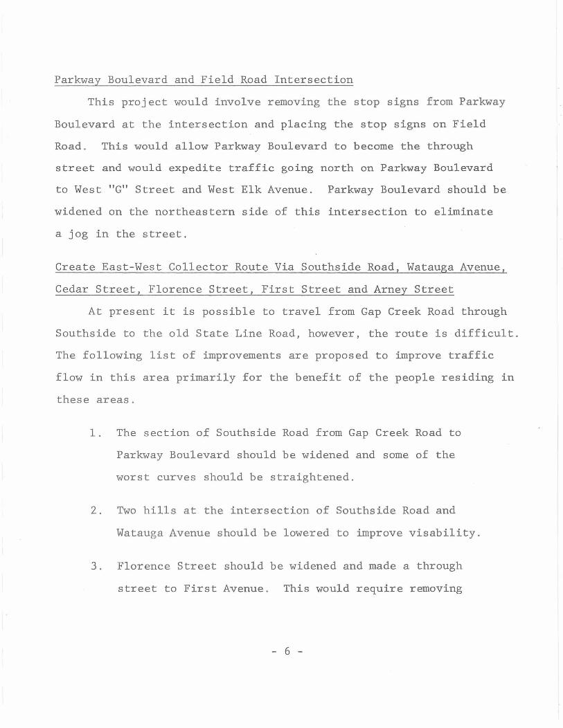
Extend Sycamore Street to Connect with 19-E Bypass
The 1970 Major Thoroughfare Plan showed this proposed extension
of Sycamore Street to the bypass. This project would provide a
northerly route for the dissipation of traffic within the city.
- 10 -

Figure 9
Figure 10
1 ~
/..._
I I I I
This picture shows Florence Street facing east at the intersection of Johnson Avenue and First Avenue. The street jog should be removed and stop signs be placed on Johnson making Florence a through street.
---
This picture shows the picture above. Avenue facing west
the same intersection discussed in This picture was taken from First
- 11 -

Figure 11
Figure 12
This curve on Arney Street should be straightened to ;, improve traffic flow.
A short road should be constructed from this intersection eastward to Old Stoney Creek Road
- 12 -

This road would encourage more traffic in the downtown area and
slightly relieve congestion at the Broad Street and Elk Avenue
areas.
- 13 -
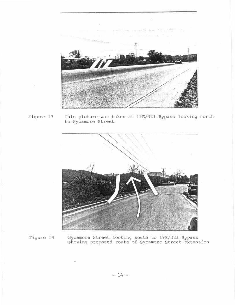
Figure 13
Figure 14
This picture was taken at 19E/321 Bypass looking north to Sycamore Street
Sycamore Street looking south to 19E/321 Bypass showing proposed route of Sycamore Street extension
- 14 -

UPDATE OF THOROUGHFARE PLAN
Since the Major Thoroughfare Plan was prepared in 1970, there
has been numerous changes in the city's traffic patterns. If the
proposed improvements outlined in the preceding chapter are imple
mented, this will create additional changes that need to be reflected
in the Major Thoroughfare Plan. Illustration 1 shows the existing
thoroughfare plan, and Illustration 2 shows the amended thoroughfare
plan. Changes a~e summarized in the following list:
1. Watauga Road is changed from a collector street to
arterial,and old Stoney Creek Road designated arterial.
2. Hudson Drive is designated a collector street.
3. Ash Street, Riverside Drive and North Roan Street are
reclassified as local streets.
4. Parkway Boulevard from Carter Boulevard to West Elk
Avenue is designated a collector street.
5. Southside Road, Florence Street, First Avenue and Arney
Street are designated collector streets.
6. The proposed Watauga Avenue Extension to the southern
bypass is re-routed just west of the South Hills Housing
Development.
7. Siam Road is reclassified as a local street. Siam Road
is not shown on these illustrations,
- 15 -

ELIZABETHTON TENNESSEE
I I
f
ILLUSTRATION I
19 70 Major Thoroughfare Plan
' LEGEND
Arterial Streets
11111111111111.1111 Collector Streets
!ICAl.I •• •!ODO'
IOOO' '°°' 0
II
N . ~
-Y

~---------
ELIZABETHTON TENNESSEE
I I
f I I
ILLUSTRATION 2
1987 Major Thoroughfare Pl an
L E G E N D
Arterial Streets
.1.1111111111111111111 Collector Streets
!CALL 1 • • IOOO'
1000' 'SOO' 0
II

MARGINAL ACCESS STREET FOR WEST ELK AVENUE
There is only one major east-west route through Elizabethton.
This route is West Elk Avenue and Broad Street. There are numerous
proposals presented in other sections of this plan that would pro
vide alternate east-west traffic routes and methods to better
distribute the traffic, however, even if all of these proposals are
completed, West Elk Avenue and Broad Street will continue to be
heavily congested as a result of the projected increase in traffic
due to the new highway construction to Johnson City, Bristol and
Valley Forge. It is projected that the Rio Vista area will be re
developed to corrunercial uses in the near future and a large portion
of the North American and Bemberg Properties are now being re
developed . It is for these reasons that the planning commission has
proposed a plan for linking the various business and industries along
West Elk Avenue in the vicinity of the old North American and Bemberg
Properties by a marginal access road . A marginal access road simply
defined is a minor street which is parallel and adjacent to arterial
streets and highways and which provides access to abutting properties
and protection from through traffic. Illustration 3 shows the pro
posed plan for this area.
There would be a total of four traffic lights proposed for this
area of West Elk Avenue. Each of these traffic lights would be
carefully located at the intersections of Williams Avenue, Hudson
Avenue, Bemberg Road and McArthur Street . These traffic lights
- 18 -

ILLUSTRATION 3
WEST ELK AVENUE MARGINAL ACCESS PLAN
NORTH
EX !STING OR PROPOSED STREETS ______ .. FUTURE STREET PATTERNS
0 RED LIGHTS
SCALE I lNCH = 800 FEET
!WAL=l ~
HIGH SCHOOL
wAiAUGA-
r
.,

would allow traffic from the shopping areas on the north side of
West Elk Avenue to either enter West Elk Avenue or cross over to
the residential areas to the south. Other proposed improvements
are listed as follows:
1. Widening of Railroad Street and McArthur Avenue to
allow traffic from the Carter County Plaza Shopping
Center to enter West Elk Avenue at McArthur more
easily.
2. Connect W. Mill Street to Industrial Park Road.
3. Connect Bemberg Shopping Center to Industrial Park
Road.
4. Bemberg Shopping Center is already linked to the new
Wal-Mart property and Bemberg Road. Another Road
should be constructed to connect from Bemberg Road to
the new post office.
5. The North American Plant parking lot entrance should
be relocated to enter Elk Avenue at the Hudson Avenue
intersection.
6. If more of the North American property is redeveloped
a road should be constructed from the new post office
west past the hospital to the old Franklin Club property
where traffic could be channeled through a traffic
light at Williams Avenue.
- 20 -

7. If additional property is redeveloped on the North
American Plant site east and west, roads should be
constructed to link these areas with the Cherokee
Industrial Park Road.
- 21 -

Figure 15
Figure 16
This picture shows McArthur Street as it intersects with Railroad Street and West Elk Avenue. The short section of street between Railroad Street and West Elk Avenue should be widened to three lane and stop signs placed on McArthur and Railroad Street to allow traffic from the Carter County Plaza Shopping Center to flow better through this intersection
This picture shows the intersection of Hudson Drive and West Elk Avenue. The North American parking lot at left should enter West Elk Avenue at this intersection and a traffic light should be located here
- 22 -

SUMMARY
A look at the present traffic patterns within Elizabethton
show that West Elk Avenue and Broad Street are the two most heavily
traveled streets in the city, and development projections indicate
that traffic on these two streets will continue to increase rapidly
unless some action is taken.
This plan has outlined four alternate routes to facilitate the
east-west movement of traffic through Elizabethton, and two north
south routes. Restated these routes are:
1. Reopening access to West "G" Street - Gap Creek Road .
This project will provide a parallel east-west route to
the south of Elk Avenue .
2. Construct east-west marginal access road to parallel
Elk Avenue to the north and serve the shopping areas
at the Bemberg and North American properties.
3 . Improve old Stoney Creek Road to provide a northern
east-west route from Stoney Creek to Watauga.
4. Improve Southside Road, Watauga Avenue, Cedar Street,
Florence Street, and Arney Street to provide a
southern east-west route for local traffic .
5. Improve Parkway Boulevard to provide a new north-south
collector street.
- 23 -
6. Extension of Sycamore Street to 19-E Bypass to
provide a new north-south collector street.
- 24 -