Embed Size (px)
Citation preview

PROGRESS MADE IN IMPLEMENTING THE OCEAN AND COASTAL MAPPING INTEGRATION ACT: 2011–2014
PRODUCT OF THE
National Science and Technology Council
April 2015
iii
EXECUTIVE OFFICE OF THE PRESIDENT
NATIONAL SCIENCE AND TECHNOLOGY COUNCIL
WASHINGTON, D.C. 20502
April 23, 2015
Dear Colleagues:
I am pleased to transmit to you Progress Made in Implementing the Ocean and Coastal Mapping Integration Act: 2011–2014, a report to Congress produced by the Interagency Working Group on Ocean and Coastal Mapping (IWG-OCM) under the Subcommittee on Ocean Science and Technology, of the National Science and Technology Council’s Committee on Environment, Natural Resources, and Sustainability.
This document responds to requirements in the Omnibus Public Land Management Act of 2009 (P.L. 111-11), specifically the Ocean and Coastal Mapping Integration Act (P.L. 111-11, Title XII, Subtitle B). This legislation calls for “a report detailing progress made in implementing this subtitle.” The report Appendix contains the full text of the reporting requirements.
The Ocean and Coastal Mapping Integration Act requires an Interagency Committee on Ocean and Coastal Mapping. In accordance with the Ocean and Coastal Mapping Integration Act, the IWG-OCM is enhancing coordination of ocean and coastal mapping to more effectively and efficiently provide stakeholders and the public with comprehensive geospatial information in these economically and environmentally important areas.
Sincerely,
John P. Holdren Assistant to the President for Science and Technology Director Office of Science and Technology Policy

iv
About the National Science and Technology Council
The National Science and Technology Council (NSTC) is the principal means by which the Executive Branch coordinates science and technology policy across the diverse entities that make up the Federal research and development (R&D) enterprise. One of the NSTC’s primary objectives is establishing clear national goals for Federal science and technology investments. The NSTC prepares R&D packages aimed at accomplishing multiple national goals. The NSTC’s work is organized under five committees: Environment, Natural Resources, and Sustainability; Homeland and National Security; Science, Technology, Engineering, and Mathematics (STEM) Education; Science; and Technology. Each of these committees oversees subcommittees and working groups that are focused on different aspects of science and technology. More information is available at www.whitehouse.gov/ostp/nstc.
About the Office of Science and Technology Policy
The Office of Science and Technology Policy (OSTP) was established by the National Science and Technology Policy, Organization, and Priorities Act of 1976. OSTP’s responsibilities include advising the President in policy formulation and budget development on questions in which science and technology are important elements; articulating the President’s science and technology policy and programs; and fostering strong partnerships among Federal, State, and local governments, and the scientific communities in industry and academia. The Director of OSTP also serves as Assistant to the President for Science and Technology and manages the NSTC. More information is available at www.whitehouse.gov/ostp.
About the Subcommittee on Ocean Science and Technology
The purpose of the Subcommittee on Ocean Science and Technology (SOST) is to advise and assist on national issues of ocean science and technology. The SOST contributes to the goals for Federal ocean science and technology, including developing coordinated interagency strategies, and fosters national ocean science and technology priorities, including implementation of the National Ocean Policy.
About this Document
This document was developed by the Interagency Working Group on Ocean and Coastal Mapping, which advises, assists, and makes recommendations on matters related to implementation of the Ocean and Coastal Mapping Integration Act of 2009 and the National Policy for the Stewardship of the Ocean, our Coasts, and the Great Lakes (National Ocean Policy, Executive Order 13547). The document was published by OSTP.
Acknowledgements
We thank Sasha Pryborowski from the National Oceanic and Atmospheric Administration and Cindy Thatcher from the United States Geological Survey for their contributions to the drafting of this document.
Copyright Information
This document is a work of the United States Government and is in the public domain (see 17 U.S.C. §105). Subject to the stipulations below, it may be distributed and copied with acknowledgement to OSTP. Copyrights to graphics included in this document are reserved by the original copyright holders or their assignees and are used here under the government’s license and by permission. Requests to use any images must be made to the provider identified in the image credits or to OSTP if no provider is identified.
Printed in the United States of America, 2015.

v
National Science and Technology Council
Chair Staff John P. Holdren Jayne B. Morrow Assistant to the President for Science Executive Director and Technology and Director, Office of Science and Technology Policy
Committee on Environment, Natural Resources, and Sustainability
Co-Chairs Staff Tamara Dickinson Lisa Matthews Principal Assistant Director for Environment and Executive Secretary
Energy Environmental Protection Agency
Office of Science and Technology Policy Tom Burke Science Advisor Environmental Protection Agency Kathryn Sullivan Undersecretary for Oceans and Atmosphere; Administrator of the National Oceanic and Atmospheric Administration Department of Commerce
Subcommittee on Ocean Science and Technology
Co-Chairs Staff Debbie Bronk Hilary Goodwin National Science Foundation National Oceanic and Atmospheric Administration Fabien Laurier Office of Science and Technology Policy Roxanne Nikolaus National Science Foundation Richard Merrick National Oceanic and Atmospheric Administration

vi
Interagency Working Group on Ocean and Coastal Mapping
Co-Chairs
Ashley Chappell John Brock
National Oceanic and Atmospheric United States Geological Survey
Administration
Jennifer Wozencraft
U.S. Army Corps of Engineers
Members
Craig Alvord Paula Bontempi
Environmental Protection Agency National Aeronautics and Space Administration
Wayne Estabrooks Russell C. Ives
United States Navy National Geospatial-Intelligence Agency
Roger Johnson Brian Midson
National Park Service National Science Foundation
Frank Parker Paul Rooney
United States Coast Guard Federal Emergency Management Agency
Ron Salz Douglas Vandergraft
United States Fish and Wildlife Service Bureau of Ocean Energy Management

vii
Table of Contents
Executive Summary ................................................................................................................................... 1
Progress in Implementing the Ocean and Coastal Mapping Integration Act ............................................... 2
Interagency Working Group on Ocean and Coastal Mapping Accomplishments ......................................... 5
Inventory Ocean and Coastal Mapping Data – OCMIA Section 1 ............................................................. 5
Identification of Priority Survey Areas – OCMIA Section 2 ....................................................................... 6
Integrated Mapping Resources and Requirements – OCMIA Sections 3 and 8........................................ 7
Integrated Mapping Projects and Results – OCMIA Section 5 ................................................................ 10
Data and Documentation Requirements – OCMIA Section 6 ............................................................... 111
Current Ocean and Coastal Mapping Activities – OCMIA Sections 4, 7, 9, and 11 ................................. 12
Integrated digital maps status ............................................................................................................. 12
Leveraging resources and improving coordination ............................................................................ 133
Digital Coast Integrated Mapping Pilot – OCMIA Section 10 ................................................................ 144
Federal Contracting Policies – OCMIA Section 11 ................................................................................ 144
The Way Forward ...................................................................................................................................... 166
Appendix: Subtitle B – Ocean and Coastal Mapping Integration Act............................................................... 177
Abbreviations .............................................................................................................................................. 19
1
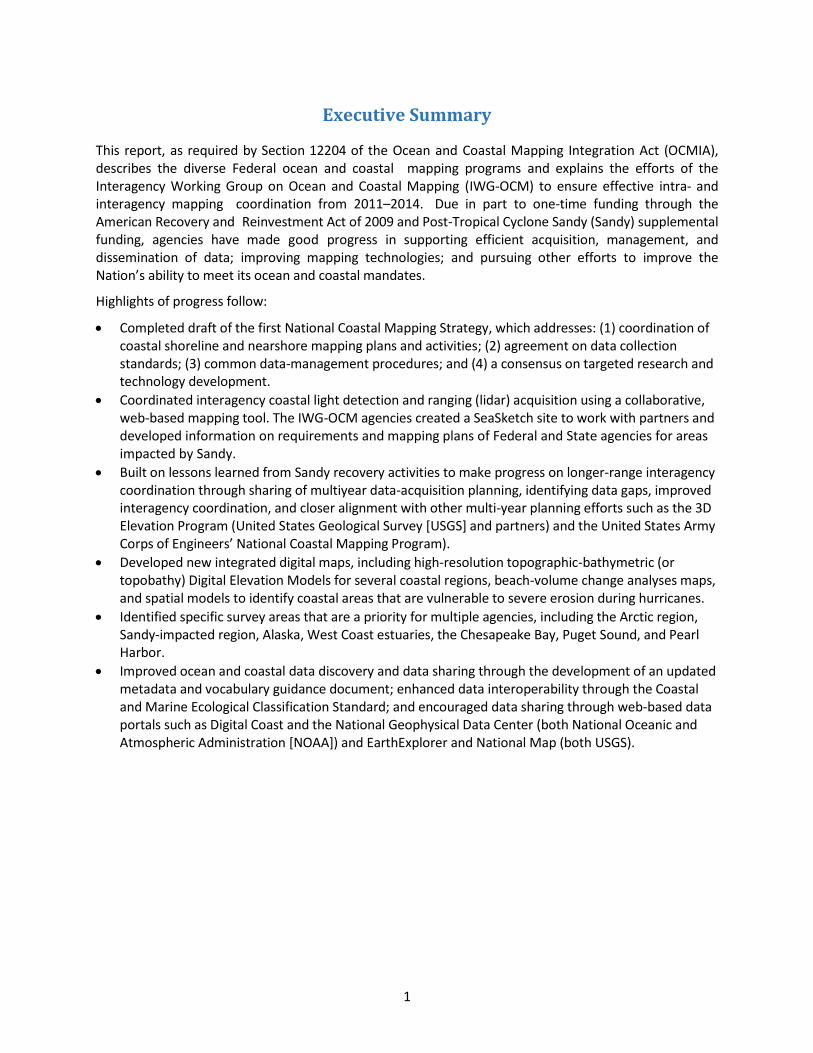
Executive Summary
This report, as required by Section 12204 of the Ocean and Coastal Mapping Integration Act (OCMIA), describes the diverse Federal ocean and coastal mapping programs and explains the efforts of the Interagency Working Group on Ocean and Coastal Mapping (IWG-OCM) to ensure effective intra- and interagency mapping coordination from 2011–2014. Due in part to one-time funding through the American Recovery and Reinvestment Act of 2009 and Post-Tropical Cyclone Sandy (Sandy) supplemental funding, agencies have made good progress in supporting efficient acquisition, management, and dissemination of data; improving mapping technologies; and pursuing other efforts to improve the Nation’s ability to meet its ocean and coastal mandates.
Highlights of progress follow:
Completed draft of the first National Coastal Mapping Strategy, which addresses: (1) coordination of coastal shoreline and nearshore mapping plans and activities; (2) agreement on data collection standards; (3) common data-management procedures; and (4) a consensus on targeted research and technology development.
Coordinated interagency coastal light detection and ranging (lidar) acquisition using a collaborative, web-based mapping tool. The IWG-OCM agencies created a SeaSketch site to work with partners and developed information on requirements and mapping plans of Federal and State agencies for areas impacted by Sandy.
Built on lessons learned from Sandy recovery activities to make progress on longer-range interagency coordination through sharing of multiyear data-acquisition planning, identifying data gaps, improved interagency coordination, and closer alignment with other multi-year planning efforts such as the 3D Elevation Program (United States Geological Survey [USGS] and partners) and the United States Army Corps of Engineers’ National Coastal Mapping Program).
Developed new integrated digital maps, including high-resolution topographic-bathymetric (or topobathy) Digital Elevation Models for several coastal regions, beach-volume change analyses maps, and spatial models to identify coastal areas that are vulnerable to severe erosion during hurricanes.
Identified specific survey areas that are a priority for multiple agencies, including the Arctic region, Sandy-impacted region, Alaska, West Coast estuaries, the Chesapeake Bay, Puget Sound, and Pearl Harbor.
Improved ocean and coastal data discovery and data sharing through the development of an updated metadata and vocabulary guidance document; enhanced data interoperability through the Coastal and Marine Ecological Classification Standard; and encouraged data sharing through web-based data portals such as Digital Coast and the National Geophysical Data Center (both National Oceanic and Atmospheric Administration [NOAA]) and EarthExplorer and National Map (both USGS).

2
Progress in Implementing the Ocean and Coastal Mapping Integration Act
Table 1 provides a quick look at progress made thus far in the 13 reporting items outlined in OCMIA. The table includes cross-reference to sections of the previous progress report covering 2009–2010. Details on accomplishments made in the present period are provided in subsequent sections of the report.
Table 1. Summary of Progress in Implementing Ocean and Coastal Mapping Integration Act
Reporting Requirements, Section 12204
Section of the 2009–2010 Progress Report
Addressing the Requirement
Updates on the Requirement Provided in this Progress Report Covering 2011–2014
More information
on Page
(1) an inventory of ocean and coastal mapping data within the territorial sea and the exclusive economic zone and throughout the Continental Shelf of the United States, noting the age and source of the survey and the spatial resolution (metadata) of the data
Inventory Ocean and Coastal Mapping Data
U.S. Interagency Elevation Inventory (NOAA, USGS, and Federal Emergency Management Agency [FEMA]) web-mapping resource:
Preparation of metadata guidance and vocabulary document for data discoverability
4
(2) identification of priority areas in need of survey coverage using present technologies
Identification of Priority Survey Areas
Post-Tropical Cyclone Sandy’s impact region
Alaska
West Coast estuaries
Chesapeake Bay
Puget Sound
Pearl Harbor
5
(3) a resource plan that identifies when priority areas in need of modern ocean and coastal mapping surveys can be accomplished
Integrated Mapping Resources and Requirements
Resources and Requirements for Federal Ocean and Coastal Mapping Data Acquisition
6
(4) the status of efforts to produce integrated digital maps of ocean and coastal areas
Status of Current Ocean and Coastal Mapping Activities; Subsection “Integrated Digital Maps”
Examples of integrated digital maps:
NOAA topobathy Digital Elevation Models for tsunami modeling
NOAA and USGS high-resolution regional topobathy Digital Elevation Models
U.S. Army Corps of Engineers (USACE) beach volume change maps
USGS models of coastal vulnerability to storm-induced erosion
11

3
Reporting Requirements, Section 12204
Section of the 2009–2010 Progress Report
Addressing the Requirement
Updates on the Requirement Provided in this Progress Report Covering 2011–2014
More information
on Page
(5) a description of any products resulting from coordinated mapping efforts under this subtitle that improve public understanding of the coasts and oceans, or regulatory decision making
Integrated Mapping Projects and Results
NOAA tools on Digital Coast: www.coast.noaa.gov/digitalcoast
USGS National Assessment of Coastal Change Hazards
FEMA Flood Insurance Risk Maps
Other FEMA flood risk products
The U.S. Extended Continental Shelf (ECS) Project
9
(6) documentation of minimum and desired standards for data acquisition and integrated metadata
Data and Documentation Requirements
Coastal and Marine Ecological Classification Standard
Updated metadata and vocabulary guidance document
Definition of quality levels for coastal topographic and bathymetric lidar developed for the National Coastal Mapping Strategy
10
(7) a statement of the status of federal efforts to leverage mapping technologies, coordinate mapping activities, share expertise, and exchange data
Status of Ocean and Coastal Mapping Activities; Subsection “Leveraging Resources and Improving Coordination”
Coordinating coastal mapping activities and sharing expertise via the Annual IWG-OCM Coastal Mapping Summit, Joint Airborne Lidar Bathymetry Technical Center of Expertise (JALBTCX) Annual Workshop, and IWG-OCM mapping coordination online tool
Completed interagency development of the new national Coastal and Marine Ecological Classification Standard
Coastal mapping data publication through NOAA Digital Coast, NOAA National Geophysical Data Center, USGS National Map, USGS EarthExplorer, National Science Foundation (NSF) project funding mechanism
11
(8) a statement of resource requirements for organizations to meet the goals of the program, including technology needs for data acquisition, processing, and distribution systems
Integrated Mapping Resources and Requirements
Given current declining resources for mapping, Federal agencies are only able to map the sandy ocean coasts of the continental United States on a multi-decadal basis. More resources are required to add key areas like estuaries, or increase the repeat frequency of data collection
6

4
Reporting Requirements, Section 12204
Section of the 2009–2010 Progress Report
Addressing the Requirement
Updates on the Requirement Provided in this Progress Report Covering 2011–2014
More information
on Page
(9) a statement of the status of efforts to declassify data gathered by the Navy, the National Geospatial-Intelligence Agency, and other agencies to the extent possible without jeopardizing national security, and make it available to partner agencies and the public
Status of Current Ocean and Coastal Mapping Activities
No changes since 2009-2010 progress report N/A
(10) a resource plan for a digital coast integrated mapping pilot project for the northern Gulf of Mexico that will—
(A) cover the area from the authorized coastal counties through the territorial sea;
(B) identify how such a pilot project will leverage public and private mapping data and resources, such as the United States Geological Survey National Map, to result in an operational coastal change assessment program for the subregion
Digital Coast Integrated Mapping Pilot
NOAA worked with the Northern Gulf Institute and the National Association of Counties to conduct a two-day Digital Coast workshop for the six coastal counties in Mississippi to help them share issues, identify common needs, and determine if data and tools available via the Digital Coast could help them increase their resiliency
High-resolution integrated topobathy elevation maps produced for Mobile Bay and coastal Louisiana
13
(11) the status of efforts to coordinate Federal programs with coastal State and local government programs and leverage those programs
Status of Ocean and Coastal Mapping Activities; Subsection “Leveraging Resources and Improving Coordination”
Examples:
Post-Tropical Cyclone Sandy’s mapping coordination
Development of the National Coastal Mapping Strategy
USACE National Coastal Mapping Program planning
11
(12) a description of efforts of federal agencies to increase contracting with nongovernmental entities
Federal Contracting Policies
IWG-OCM member agencies successfully executed multiple contracts for coastal surveys after Post-Tropical Cyclone Sandy, e.g., USACE executed 76 percent of its coastal mapping budget through contracts
13
(13) an inventory and description of any new federal or federally funded programs conducting shoreline delineation and ocean or coastal mapping since the previous reporting cycle
N/A No new programs identified N/A
5
Interagency Working Group on Ocean and Coastal Mapping Accomplishments
The Interagency Working Group on Ocean and Coastal Mapping (IWG-OCM) has improved coordination and collaboration on requirements integration, on project planning and execution, and on support of efficient and appropriate data acquisition. The following subsections highlight recent efforts.
Inventory Ocean and Coastal Mapping Data (OCMIA Section 1)
In 2009, IWG-OCM workshop participants identified certain mapping data as essential to support research, management, and planning efforts in the ocean and coastal zone. These include critical framework data layers for elevation below and above the water (e.g. bathymetry and coastal topography); imagery data describing surface characteristics such as land cover, built areas, and seafloor habitat; and geophysical data, such as seismic and shoreline data that describe the surface and subsurface of the seafloor. The IWG-OCM continues to focus on these framework datasets.
During 2010–2012, partner agencies that maintain repositories for Federal and academic public framework data developed a pilot integrated ocean and coastal mapping inventory using geoportal technologies based on survey metadata following metadata and vocabulary guidelines. The pilot inventory was tested for a variety of use cases, including support for survey planning and data discovery. The results of the testing identified several challenges in implementing this approach, including display of multiple surveys in a single map view, and successful keyword searches for data discovery when controlled vocabularies were used inconsistently in metadata. These challenges were presented to teams at government web-based portals Data.gov and the National Geospatial Platform (GeoPlatform) as the teams were developing and improving the portals for Federal geospatial data. While agencies continue to improve and load metadata into Data.gov, the focus both for integrated survey planning and for data discovery is shifting to geospatial web-map services linked to the metadata and underlying data. The IWG-OCM developed metadata guidance to be implemented by IWG-OCM members to increase the consistency of ocean and coastal mapping metadata and improve the ability to search for ocean and coastal mapping data in these systems.
Further, the National Oceanic and Atmospheric Administration (NOAA) and an interagency team have built a community (at www.oceans.data.gov) that includes a curated inventory of ocean and coastal mapping data sets and provides other related information for the ocean and coastal mapping community. The IWG-OCM’s long-term vision is to optimize tools in Data.gov to serve metadata to the oceans community while using the federally sanctioned National GeoPlatform as the primary survey-planning tool. The National GeoPlatform will enable collaborative survey planning when populated with the spatial extents of planned surveys and kept current with web-map services from the primary repositories depicting existing data. At present, the National GeoPlatform is under development so the IWG-OCM is using a collaborative, web-based map service called SeaSketch to share survey plans for 2013–2015 and beyond. Information about planned mapping areas, proposed survey dates, primary contact, and data collection plans can be viewed, modified, and annotated, and the extents of existing data can be layered to highlight data gaps.
NOAA, the U.S. Geological Survey (USGS), and the Federal Emergency Management Agency (FEMA) have also created the U.S. Interagency Elevation Inventory (USIEI), a web-based resource for elevation data that complements Data.gov and the National GeoPlatform. The USIEI is a comprehensive, nationwide listing of known high-accuracy topographic data, including light detection and ranging (lidar) and interferometric synthetic aperture radar data, and bathymetric data, including hydrographic surveys, multibeam data, and bathymetric lidar. Data sets shown in the National GeoPlatform include those from IGW-OCM agencies, states, academia, and other partners. The information provided for each elevation dataset

6
includes many attributes such as vertical accuracy, point spacing, and date of collection. A direct link to access the data or information about the contact organization is also available through the Inventory (www.coast.noaa.gov/inventory).
Identification of Priority Survey Areas (OCMIA Section 2)
Ocean and coastal mapping data support the mapping applications required to meet the Nation’s economic natural-resource preservation and management needs. The IWG-OCM has promoted increased interagency planning and coordination on ocean and coastal mapping to establish priorities, maximize limited resources, and produce data that can be used for multiple purposes.
To accomplish this goal, IWG-OCM member agencies sponsor workshops and meetings to engage with stakeholders, and use tools for interagency planning. For example, the IWG-OCM now convenes an annual coastal mapping summit to identify opportunities to coordinate planned mapping activities. The Joint Airborne Lidar Bathymetry Technical Center of Expertise (JALBTCX) partner agencies (United States Army Corps of Engineers [USACE], United States Naval Oceanographic Office [NAVO], NOAA, and USGS) hold quarterly teleconferences and an annual face-to-face interagency meeting focused on interagency collaboration in the planning and execution of coastal mapping activities. Individual agencies collect priority mapping requirements regularly to feed their planning processes (e.g., NOAA’s process to continually update its Hydrographic Survey Priorities document, available at www.nauticalcharts.noaa.gov/hsd/NHSP.htm).
Additionally, JALBTCX partners and other agencies conducted coordinated coastal mapping, planning and execution using the IWG-OCM Sandy Coordination site using the Seasketch software-as-a-service tool (www.seasket.ch/10iUg1JVn1). SeaSketch is a mapping application and web-based forum for interagency coordination for ocean and coastal mapping that was launched in early 2013. The Sandy SeaSketch site was first used by Federal mapping agencies collaborating to collect information on requirements and plans of Federal and State agencies for areas impacted by Sandy. The IWG-OCM’s goal was to ensure that Sandy emergency supplemental funding was used to “map once, use many times.” The kinds of mapping activities included were requirements and plans in the Sandy-impacted region for: hydrographic surveys (side scan/single/multibeam); topographic, bathymetric, and topobathy lidar; digital imagery; hyperspectral imagery, and other types of ocean and coastal mapping data. Lastly, the IWG-OCM partner agencies continue to enhance their coordination of lidar coastal mapping through development of the National Coastal Mapping Strategy.
The IWG-OCM has also identified specific priority survey areas including the Arctic region and the Sandy impacted region, Chesapeake Bay, West Coast estuaries, and Puget Sound. The Alaskan Arctic region was identified as a priority because of the need for improved mapping and charting for safe navigation; accurate positioning; and support for sustained protection of key biological habitats, subsistence use areas, and vulnerable coastlines. The coastal and nearshore zones in the Sandy impact region were prioritized to support coastal restoration activities; damage assessments; the development of updated flood maps and navigation charts; shoreline delineation; coastal geomorphology studies; and many other applications conducted by multiple Federal, State, and local government agencies.
The USACE districts and local stakeholders, NOAA, and USGS have identified coastal regions that are high priorities for lidar surveys, but are not covered by the USACE National Coastal Mapping Program (NCMP), which is designed to provide high-resolution elevation and imagery data along sandy, outer coast shorelines of the United States in support of regional sediment management for USACE navigation projects. Priority regions not covered by NCMP include several estuaries in Oregon (Columbia River, Tillamook Bay, Yaquina River, Suislaw River, Coos Bay, Coquille River, and Rogue River). Within the Puget Sound, USGS identified Samish Bay, Padilla Bay, Fidalgo Bay, Port Gamble, Nisqually River, Skagit Bay/Stillaguamish River,
7
Edmonds/Everett Waterfront, Tacoma Narrows, Whidbey Island, Cherry Point Aquatic Reserve/Point Whitehorn Marine Reserve, Nooksack River, and the Snohomish Estuary River. In California, USACE districts have identified the Santa Ana River watershed and additional coverage for the Port of Long Beach. USGS and USACE both added funding to 2014 NCMP operations on the west coast to survey many of these areas. On the east coast, many stakeholders have requested bathymetry data in the very shallow nearshore areas of the Chesapeake Bay, as seen in NOAA’s Hydrographic Survey Priorities document.
Integrated Mapping Resources and Requirements (OCMIA Sections 3 and 8)
Federal agencies have historically planned and conducted ocean and coastal mapping activities based on specific requirements, mandates, and available funding. Recognizing the need to improve coordination, the IWG-OCM continues to identify mapping requirements and resources across the Federal Government, as illustrated by Table 2. Work continues at the IWG-OCM to align standards, specifications, acquisitions, and multipurpose use of the data.
Additional resource requirements exist across all ocean and coastal mapping agencies. Ocean and coastal mapping technologies continue to evolve, a development that is enabling acquisition of more high-resolution data describing the coast, seafloor, and water column. New state-of-the-art multibeam mapping systems and greater focus on procedures and training in survey planning, at-sea data acquisition and processing practices, as well as post-processing techniques are being implemented in order to fully realize the maximum benefits from these systems. There are also new topobathy lidar instruments with improved capabilities, such as the USACE Coastal Zone Mapping and Imaging Lidar, and the USGS Experimental Advanced Airborne Research Lidar-B.
Ocean and coastal mapping data are made available to the public through several web-based data portals. NOAA’s Digital Coast (www.coast.noaa.gov/digitalcoast) is a user-friendly portal that provides public access to ocean and coastal data collected by NOAA, USGS, USACE’s JALBTCX, State and county governments, and non-governmental organizations. NOAA’s National Geophysical Data Center (NGDC; www.ngdc.noaa.gov) provides a long-term archive for and access to the Nation’s ocean and coastal data, including data collected by many government agencies, universities, and non-governmental organizations. The USGS EarthExplorer and the National Map data portals also provide public access to coastal and ocean data, such as satellite imagery, lidar, land cover data, digital elevation models (DEMs), and many other types of data frequently used by Federal, State, local, and foreign governments; industry, academia, and the general public.
8
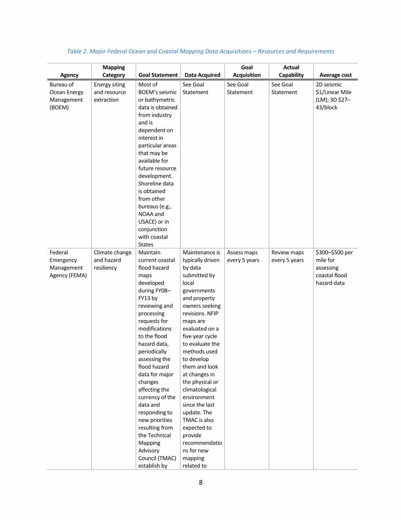
Table 2. Major Federal Ocean and Coastal Mapping Data Acquisitions – Resources and Requirements
Agency Mapping Category Goal Statement Data Acquired
Goal Acquisition
Actual Capability Average cost
Bureau of Ocean Energy Management (BOEM)
Energy siting and resource extraction
Most of BOEM’s seismic or bathymetric data is obtained from industry and is dependent on interest in particular areas that may be available for future resource development. Shoreline data is obtained from other bureaus (e.g., NOAA and USACE) or in conjunction with coastal States
See Goal Statement
See Goal Statement
See Goal Statement
2D seismic $1/Linear Mile (LM); 3D $27–43/block
Federal Emergency Management Agency (FEMA)
Climate change and hazard resiliency
Maintain current coastal flood hazard maps developed during FY08–FY13 by reviewing and processing requests for modifications to the flood hazard data, periodically assessing the flood hazard data for major changes affecting the currency of the data and responding to new priorities resulting from the Technical Mapping Advisory Council (TMAC) establish by
Maintenance is typically driven by data submitted by local governments and property owners seeking revisions. NFIP maps are evaluated on a five year cycle to evaluate the methods used to develop them and look at changes in the physical or climatological environment since the last update. The TMAC is also expected to provide recommendations for new mapping related to
Assess maps every 5 years
Review maps every 5 years
$300–$500 per mile for assessing coastal flood hazard data

9
Agency Mapping Category Goal Statement Data Acquired
Goal Acquisition
Actual Capability Average cost
recent National Flood Insurance Program (NFIP) reforms
future conditions flood hazards including the best available climate science and information on sea level rise
National Oceanic and Atmospheric Administration (NOAA)
Navigation, transportation, and security
Re-survey hydrographic areas every 50 years and open shoreline every 10 years
Hydrography: acoustic and lidar Shoreline: photography and lidar
10,000 square nautical miles (SNM) per year 95,000 LM per year
3,000 SNM per year 3,100 LM per year
$18K/SNM $2.7K/LM
NOAA Climate change, hazard resiliency
Elevation data at 10-meter horizontal/10-centimeter vertical resolution for high hazard/ change areas
Hydrography, shoreline, and lidar in coordination with other programs
Complete initial products of priority areas, with focus on Alaska
Dependent upon partner capabilities
None identified, partner with other programs for ocean and coastal mapping data
NOAA Ecosystem-based management
Consistently/ comprehensively map distribution of benthic habitats; cultural resources
Multibeam echosounder, side scan sonar, ground truth species surveys
Ocean and coastal mapping varies widely by region and FY, goal is to map coastal US with 15 meter resolution data
2 or more surveys/year plus coordination with partner programs
$400K–$1.2 M/year
NOAA Climate change and hazard resiliency
Map coastal bathymetry, topography and geologic framework
Acoustic, lidar, satellite imagery
Accomplished through interagency partnerships; long-term plan does not exist
Limited to interagency partnerships
$100K/year
National Park Service (NPS)
Ecosystem- based management
Map submerged habitats and associated natural and cultural resources
Acoustic, lidar, satellite imagery
Accomplished through interagency partnership; strategy for data acquisition being developed
Limited to interagency partnerships
$250K/year
U.S. Army Corps of Engineers (USACE)
Regional sediment management
Project management of coastal navigation, flood damage risk reduction, environmental restoration
Bathymetric and topographic lidar, aerial photography and hyperspectral imagery, beach
As required by project activities
Varies with technology
Varies greatly by mission need and survey technology
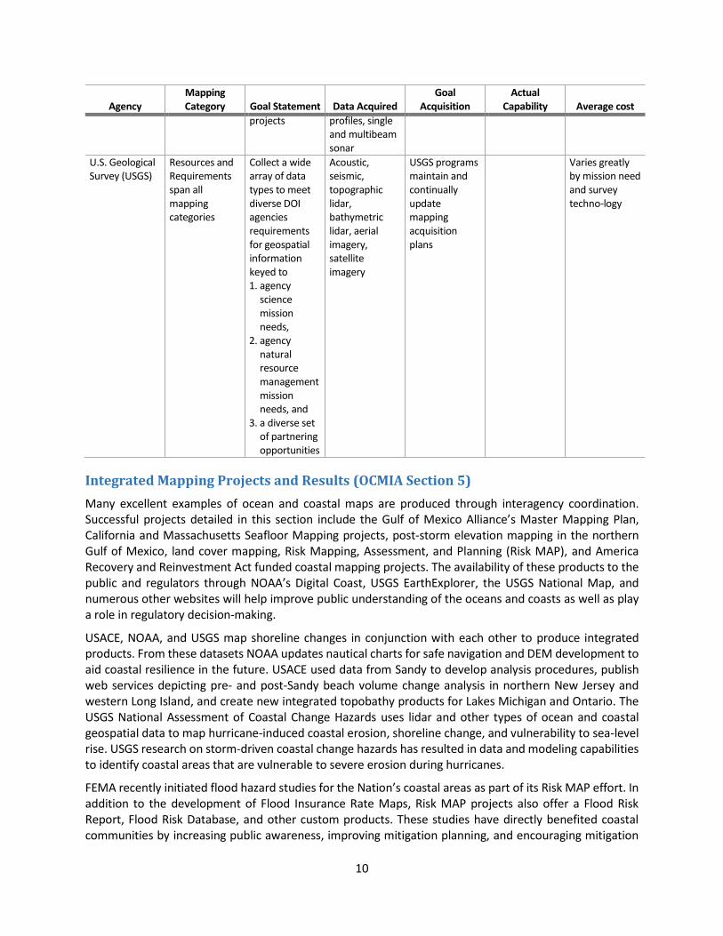
10
Agency Mapping Category Goal Statement Data Acquired
Goal Acquisition
Actual Capability Average cost
projects profiles, single and multibeam sonar
U.S. Geological Survey (USGS)
Resources and Requirements span all mapping categories
Collect a wide array of data types to meet diverse DOI agencies requirements for geospatial information keyed to 1. agency
science mission needs,
2. agency natural resource management mission needs, and
3. a diverse set of partnering opportunities
Acoustic, seismic, topographic lidar, bathymetric lidar, aerial imagery, satellite imagery
USGS programs maintain and continually update mapping acquisition plans
Varies greatly by mission need and survey techno-logy
Integrated Mapping Projects and Results (OCMIA Section 5)
Many excellent examples of ocean and coastal maps are produced through interagency coordination. Successful projects detailed in this section include the Gulf of Mexico Alliance’s Master Mapping Plan, California and Massachusetts Seafloor Mapping projects, post-storm elevation mapping in the northern Gulf of Mexico, land cover mapping, Risk Mapping, Assessment, and Planning (Risk MAP), and America Recovery and Reinvestment Act funded coastal mapping projects. The availability of these products to the public and regulators through NOAA’s Digital Coast, USGS EarthExplorer, the USGS National Map, and numerous other websites will help improve public understanding of the oceans and coasts as well as play a role in regulatory decision-making.
USACE, NOAA, and USGS map shoreline changes in conjunction with each other to produce integrated products. From these datasets NOAA updates nautical charts for safe navigation and DEM development to aid coastal resilience in the future. USACE used data from Sandy to develop analysis procedures, publish web services depicting pre- and post-Sandy beach volume change analysis in northern New Jersey and western Long Island, and create new integrated topobathy products for Lakes Michigan and Ontario. The USGS National Assessment of Coastal Change Hazards uses lidar and other types of ocean and coastal geospatial data to map hurricane-induced coastal erosion, shoreline change, and vulnerability to sea-level rise. USGS research on storm-driven coastal change hazards has resulted in data and modeling capabilities to identify coastal areas that are vulnerable to severe erosion during hurricanes.
FEMA recently initiated flood hazard studies for the Nation’s coastal areas as part of its Risk MAP effort. In addition to the development of Flood Insurance Rate Maps, Risk MAP projects also offer a Flood Risk Report, Flood Risk Database, and other custom products. These studies have directly benefited coastal communities by increasing public awareness, improving mitigation planning, and encouraging mitigation
11
actions. FEMA leverages data from the IWG-OCM agencies, such as USACE and NOAA, and other sources to develop Risk MAP products; its results and data are available to support resilience. The Risk MAP progress website, www.riskmapprogress.msc.fema.gov, is updated quarterly and offers an interactive look at progress status across the country. Another mapping coordination effort comes from the U.S. Extended Continental Shelf (ECS) Project. This project is a multi-agency collaboration intended to establish the full extent of the continental shelf of the United States, consistent with international law. The process to determine the outer limits of the U.S. ECS requires the collection and analysis of data that describe the depth, shape, and geophysical characteristics of the seabed and sub-sea floor. In 2014, NOAA-led teams completed two successful ECS-related mapping cruises in the Pacific. One was in the vicinity of Johnston Atoll, where the team acquired 13,064 square kilometers of multibeam bathymetry and discovered and mapped a previously unknown seamount within the new Remote Pacific Islands National Monument. The second was along the Mendocino Ridge off the coast of central California, acquiring 103,070 square kilometers of multibeam bathymetry, including a large region of dormant seafloor volcanoes, a large area of subsea lava flows, and the first complete mapping of Boutelle Seamount. The USGS also completed a successful seismic cruise in the Atlantic during 2014, acquiring more than 2760 km of seismic, multibeam bathymetry, and other geophysical data in deep water between southern New England and North Carolina. In addition to imaging sediment thickness off the margin for ECS objectives, the cruise imaged, for the first time, the entire length of the Cape Fear landslide, a 375-km long large, recently active and long-lived landslide to better understand U.S. East Coast tsunami hazards. The ECS Project also made significant progress in utilizing the mapping products to prepare materials and GIS products to support the analysis of potential areas of extended continental shelf, including areas in the Arctic. The ECS Task Force is headed by the U.S. Department of State, with co-vice chairs from Department of Interior and NOAA. Participants include: the Executive Office of the President, U.S. Geological Survey, Joint Chiefs of Staff, U.S. Navy, U.S. Coast Guard, Department of Energy, National Science Foundation, Environmental Protection Agency, the Bureau of Ocean Energy Management, and the Arctic Research Commission.
Data and Documentation Requirements (OCMIA Section 6)
The IWG-OCM supports a “whole ocean” approach to management and planning, leveraging limited resources by identifying common mapping requirements across programs and agencies. Essential aspects of integrated ocean and coastal mapping include the abilities to (1) acquire and process data for multiple uses; (2) generate products meeting differing requirements; (3) deliver data, derived products, and supporting metadata in a way that enables integration; and (4) turn oceans of data into relevant information supporting ecosystem-based decision-making. Modern data management and effective long-term stewardship enables the “map once, use many times” goal of the IWG-OCM, helping to reduce duplication of mapping efforts, facilitate cooperative mapping activities, and improve data accessibility.
The IWG-OCM has made progress towards documenting standards for lidar acquisition by building upon the early success of JALBTCX in establishing consistent quality levels for coastal lidar, which provide a means of consistently comparing specifications across agencies to facilitate coordination to meet cross-agency needs. This first draft of the National Coastal Mapping Strategy includes quality levels that specify vertical uncertainty (accuracy) and point density for bathymetric lidar surveys, similar to the approach taken by the USGS-led 3D Elevation Program for topographic lidar quality levels.
Lidar data stewardship ensures that the data are accurately described in standards-based metadata records to support Internet search and discovery tools. Lidar metadata records are currently generated in
12
the FGDC standard by Federal agencies and vendors who collect the data. These records are updated as the data are transferred to other agencies for dissemination and archiving, which occurs before the records are published to metadata portals such as Data.gov. NOAA, USGS, Bureau of Ocean Energy Management (BOEM), and University-National Oceanographic Laboratory System adopted common International Organization for Standardization metadata templates for the following Ocean and Coastal Mapping metadata: cruise level, multibeam bathymetry, gravity, seismic, magnetic, and geologic samples. The IWG-OCM has also provided an updated metadata and vocabulary guidance document to the National Ocean Council Data and Information Working Group. The goal of metadata guidance is to improve data discovery and accessibility by promoting common standards across agencies for comprehensive metadata records that include essential information for data evaluation and re-use.
Finally, a new integrated mapping tool is the Coastal and Marine Ecological Classification Standard (CMECS, www.coast.noaa.gov/digitalcoast/publications/cmecs). NOAA led an interagency effort through the Federal Geographic Data Committee (FGDC) that finalized in 2012 this new Federal standard to classify habitat types consistently and seamlessly across the land-sea interface where many coastal habitats exist. Previously, there were multiple classification systems, some developed for land use mapping and others associated with marine charts. CMECS is a common language for describing habitat types that is useful for mapping coastal resources, performing habitat status and trend analyses, and prioritizing habitats in need of conservation. The CMECS tool can now be applied to bring disparate data into a common framework for analysis, an important advancement for habitat conservation, fisheries management, and coastal and marine spatial planning. It has already been adopted by the National Park Service (NPS) in its post-Sandy work, the Northeast Regional Ocean Council as its habitat framework, and the Oregon Coastal Management Program to produce updated estuary habitat maps.
Current Ocean and Coastal Mapping Activities (OCMIA Sections 4, 7, 9, and 11)
Integrated digital maps
Topobathy DEMs are a merged rendering of both topography (land elevation) and bathymetry (water depth) that provides a seamless elevation product useful for inundation mapping, as well as for other Earth science applications, such as the development of sediment-transport, sea-level rise, and storm-surge models. A high-resolution (3-meter) integrated topobathy elevation model was produced for the Mobile Bay area as part of the USGS Coastal National Elevation Database (www.pubs.er.usgs.gov/publication/ds769). This DEM was developed using multiple topographic and bathymetric datasets, collected on different dates by USGS, USACE, NOAA, and other organizations.
NOAA’s NGDC and USGS are collaborating on the development of a common methodology for creating integrated topobathy DEMs. This methodology is being implemented in the area affected by Sandy-, which will result in both a consistent repeatable methodology, and integrated seamless topobathy data sets for coastal areas of New York and New Jersey.
NGDC also works with the World Data Service for Geophysics to compile integrated datasets for tsunami modeling as part of a long-term program to support tsunami warning centers, oceanographers, seismologists, engineers, and the general public. NGDC’s topobathy DEMs are used in tsunami forecasting and modeling efforts to simulate tsunami generation, propagation, and inundation. NGDC makes the data available through a publicly accessible website: www.ngdc.noaa.gov/mgg/inundation/tsunami/inundation.html. The long-term vision is to leverage the methods and capability developed for the areas affected by Sandy to extend to both tsunami and storm surge at-risk shorelines, generating DEMs appropriate to the specific need from the same underlying data.
13
The Essential Fish Habitat (EFH) Mapper (www.habitat.noaa.gov/protection/efh/habitatmapper.html) is a primary screening tool now used routinely by Federal agency managers, planners, and permit applicants who need to know if a proposed action could potentially affect EFH, as required by Federal law. NOAA and regional Fishery Management Councils are collaborating to provide the public with up-to-date EFH data and maps. The EFH Mapper was developed as a one-stop shop for spatial information on those habitats designated in Federal fishery management plans as areas or conditions essential for fish spawning, breeding, feeding, or growth. It enables users to obtain and view EFH information for a specific location, integrated from multiple fishery management plans. A significant update to the EFH Mapper was completed in July 2012.
Leveraging resources and improving coordination
The first formal Coastal Mapping Coordination Summit occurred in November 2013. Also in 2013, a subcommittee of the IWG-OCM began developing a draft National Coastal Mapping Strategy (NCMS) that incorporates a comprehensive interagency plan for coordinated lidar mapping of the littoral zone, including topography and shallow nearshore bathymetry, mapping standards, and data stewardship standards. The IWG-OCM is conducting a final review of the draft NCMS, after which it will send the draft to the Subcommittee on Ocean Science and Technology for review and eventual public rollout.
Recognizing the importance of coordinating activities and using consistent standards for coastal mapping, the IWG-OCM is aligning the NCMS with the USGS-led 3D Elevation Program (3DEP) Plans. 3DEP strives to systematically collect enhanced elevation data in the form of high-quality lidar data over the conterminous United States, Hawaii, and U.S. territories on an 8-year schedule. The NCMS and 3DEP implementation teams are working to coordinate their project planning schedules to the extent possible and to maximize consistency between their respective initiatives in terms of data standards, survey specifications, and lidar quality level definitions.
In 2013, the JALBTCX partner agencies (USACE, NAVO, NOAA, and USGS) held quarterly teleconference and a face-to-face meetings focused on interagency collaboration in planning and execution of coastal mapping activities. Additionally, these and other agencies conducted coordinated coastal mapping planning and execution first using the IWG-OCM Sandy Coordination SeaSketch site and later using a site established for national mapping coordination (www.seasket.ch/xgxNBdJVTx). IWG-OCM partner agencies began enhancing their coordination of lidar coastal mapping through implementation of the NCMS, and will continue NCMS implementation through 2015 and beyond.
The National Science Foundation (NSF) supports ocean and coastal mapping projects by providing assistance awards in the form of grants and cooperative agreements, primarily to researchers in academia. Proposals for support of research that includes ocean and coastal mapping activities are peer reviewed according to the standards of the program of interest. The majority of support from NSF for ocean and coastal mapping is provided through programs in the NSF Division of Ocean Sciences (OCE). When OCE funds a research project where ocean and coastal mapping data are collected, awardees are required to follow the Division of Ocean Sciences Sample and Data Policy (www.nsf.gov/pubs/2011/nsf11060/nsf11060.pdf), which states, in part:
PIs are required to submit, at no more than incremental cost and within a reasonable time frame (but no later than two (2) years after the data are collected), the primary data, samples, physical collections and other supporting materials created or gathered in the course of work under NSF/OCE grants to the appropriate Data Center.
The NSF/OCE requirement for data submission may be satisfied through use of NOAA’s NGDC, or other permanent accessible archive, as described in the Policy. In this way, data gathered with funding from the

14
NSF is made available for unrestricted use, including scientific research and Federal, State, or Local regulatory uses.
FEMA attributes much of the success of the Risk MAP program to collaboration with the Cooperating Technical Partners (CTP) Program. The CTP Program is an innovative approach to creating partnerships between FEMA, National Flood Insurance Program communities, regional agencies, State agencies, tribes, and universities that have the interest and capability to become more active participants in FEMA flood hazard mapping initiatives. CTP Program participants are relied on to maintain up-to-date flood hazard maps and other flood hazard information.
Digital Coast Integrated Mapping Pilot (OCMIA Section 10)
As described in the 2009–2010 IWG-OCM Report to Congress, a Digital Coast Northern Gulf of Mexico resource plan was developed, which included purchase and development of topographic and bathymetric data for the Northern Gulf of Mexico. However, funds were not made available for data acquisition. In lieu of this original plan, NOAA worked with the Northern Gulf Institute and the National Association of Counties (NACo) to conduct a two-day Digital Coast workshop for the six coastal counties in Mississippi to help them share issues, identify common needs, and determine if data and tools available via the Digital Coast could help them increase their resiliency.
Workshop participants included Digital Coast partners, NACo members from their national and local offices, as well as city planners, land trust executive directors, researchers, and private sector companies. The goals of the workshop were to identify key concerns and vulnerabilities, share natural hazards coping strategies, learn about resources available through the Digital Coast, and improve links to the Mississippi Digital Earth Model project.
Outcomes from the workshop indicated that the Mississippi coastal communities needed aerial imagery updated at 6-month intervals, improved coordination on data access issues, and challenges in post-events/storm recovery. The participants were pleased to learn about the resources available via the Digital Coast and thought many could help address their needs.
Federal Contracting Policies (OCMIA Section 11)
No single agency has the financial resources to fulfill all its ocean and coastal mapping mission requirements. The IWG-OCM agencies all recognize that qualified commercial sources can provide competent, professional, and cost-effective ocean and coastal mapping services and expertise in support of diverse agency mapping missions. Each agency has policies in place regarding collection contracts for ocean and coastal mapping data that are described in the 2009–2010 IWG-OCM Report to Congress. During the 2011–2014 period, IWG-OCM member agencies successfully and efficiently contracted with multiple commercial sources for acquisition of ocean and coastal mapping data, including the notable acquisition of coastal lidar data and imagery in the aftermath of Sandy. In some cases, data acquisition began within a week of Sandy’s landfall to support disaster recovery efforts and scientific studies of storm impacts.
NOAA is one agency with a long history of contracting for ocean mapping services. It is incumbent upon NOAA to maintain operational ocean and coastal mapping expertise and supplement its operational capacity by contracting for ocean and coastal mapping services when feasible. To better leverage government mapping resources, NOAA makes its coastal geospatial and hydrographic services contracts with private-sector companies available to State and local government entities that have a need for the services provided by these contracts and can provide adequate funding. This process facilitates increased synergy in planning and executing surveys of mutual interest. To foster improved
15
end-data interoperability, NOAA references relevant Federal standards whenever appropriate in contracted projects.
Since 1998 NOAA has awarded over $400 million of task orders for hydrographic surveying services that provide data to update nautical charts and support a wide variety of integrated ocean and coastal mapping users. In FY 2013, Post-Tropical Cyclone Sandy appropriations provided $14 million to support survey efforts to assess the changes in bathymetry along the shore and inlets affected by the storm. These surveys will be used to update nautical charts and improve future storm surge models. The data will be publicly and freely available to support a wide range of users. NOAA has recently awarded new 5-year contracts to eight firms to ensure it has the contracting capacity for all future requirements. The new contracts have a $250 million program ceiling.
USACE also offers a good example of Federal mapping contracting. During the time period represented by this report, the JALBTCX executed 75.8 percent of the funding it received for mapping through eight indefinite-delivery, indefinite-quantity survey and mapping contracts. The remaining funds were used for contract management, quality assurance and quality control of data, and development of new information products using ocean and coastal mapping data. During the reporting period, over 15 billion new elevation and depth measurements were made for over 4,000 square miles of key coastal areas including:
Barrier Islands in Louisiana, Mississippi, and Alabama
Atlantic coast between and including Newburyport, Massachusetts, to Seabrook, New Hampshire
Select areas of Lake Superior
U.S. shorelines of Lake Ontario, Lake Erie, and Lake Huron
Shorelines of Green Bay, Lake St. Clair, and Lake Michigan
Barnegat Bay/Little Egg Harbor Complex
Federal navigation projects in New England
Shorelines of Oahu, Kauai, Hawaii, Molokai, Maui, Lanai, and a portion of Niihau

16
The Way Forward
The IWG-OCM agencies remain committed to advancing the goals of OCMIA and integrated ocean and coastal mapping. The partners will continue to expand interagency coordination through multiple avenues, including using web-based planning tools for greater collaboration on data acquisition planning, and interagency agreements for shared data acquisition and simplified contracting. Priorities include advancing best practices and standards for ocean and coastal mapping, and promoting the transfer of data to national archives. The IWG-OCM also plans to continue building stronger links to national and regional planning bodies such as 3DEP, the National Digital Elevation Program, the USGS National Geospatial Liaison Network, and the States to work towards coordination of mapping data acquisition, particularly that of lidar and acoustic data. IWG-OCM agencies will also leverage the finalized National Coastal Mapping Strategy into an outreach tool to encourage adherence to a minimum set of established standards and partnerships across Federal and State governments, academia, and other non-governmental organizations. Next steps for the NCMS include expanding beyond the current focus on topobathy lidar to include other types of coastal geospatial data such as hydrographic surveys. Progress on these actions and other OCMIA mandates will be relayed by the IWG-OCM in its next Report to Congress in 2016.

17
Appendix: Subtitle B – Ocean and Coastal Mapping Integration Act
Reproduced here are the sections of Ocean and Coastal Mapping Integration Act (Subtitle B) that are relevant to reporting requirement.
SEC. 12204. BIENNIAL REPORTS.
No later than 18 months after the date of enactment of this Act, and biennially thereafter, the co- chairmen of the Committee shall transmit to the Committees on Commerce, Science, and Transportation and Energy and Natural Resources of the Senate and the Committee on Natural Resources of the House of Representatives a report detailing progress made in implementing this subtitle, including—
(1) an inventory of ocean and coastal mapping data within the territorial sea and the exclusive economic
zone and throughout the Continental Shelf of the United States, noting the age and source of the survey
and the spatial resolution (metadata) of the data;
(2) identification of priority areas in need of survey coverage using present technologies;
(3) a resource plan that identifies when priority areas in need of modern ocean and coastal mapping
surveys can be accomplished;
(4) the status of efforts to produce integrated digital maps of ocean and coastal areas;
(5) a description of any products resulting from coordinated mapping efforts under this subtitle that
improve public understanding of the coasts and oceans, or regulatory decision making;
(6) documentation of minimum and desired standards for data acquisition and integrated metadata;
(7) a statement of the status of Federal efforts to leverage mapping technologies, coordinate mapping
activities, share expertise, and exchange data;
(8) a statement of resource requirements for organizations to meet the goals of the program, including
technology needs for data acquisition, processing, and distribution systems;
(9) a statement of the status of efforts to declassify data gathered by the Navy, the National Geospatial-
Intelligence Agency, and other agencies to the extent possible without jeopardizing national security, and
make it available to partner agencies and the public;
(10) a resource plan for a digital coast integrated mapping pilot project for the northern Gulf of Mexico
that will—
(A) cover the area from the authorized coastal counties through the territorial sea;
(B) identify how such a pilot project will leverage public and private mapping data and resources,
such as the United States Geological Survey National Map, to result in an operational coastal change
assessment program for the subregion;
(11) the status of efforts to coordinate Federal programs with coastal state and local government
programs and leverage those programs;
(12) a description of efforts of Federal agencies to increase contracting with nongovernmental entities;
and
(13) an inventory and description of any new Federal or federally funded programs conducting shoreline
delineation and ocean or coastal mapping since the previous reporting cycle.
18
Abbreviations
3D three dimensional
3DEP 3D Elevation Program
BOEM Bureau of Ocean Energy Management
CMECS Coastal and Marine Ecological Classification Standard
CTP Cooperating Technical Partner
DEM Digital Elevation Model
EFH Essential Fish Habitat
FGDC Federal Geographic Data Committee
FEMA Federal Emergency Management Agency
FY fiscal year
IWG-OCM Interagency Working Group on Ocean and Coastal Mapping
JALBTCX Joint Airborne Lidar Bathymetry Technical Center of Expertise
K thousand
lidar light detection and ranging
LM linear mile
NACo National Association of Counties
MAP Mapping, Assessment, and Planning
NAVO Naval Oceanographic Office
NCMP USACE National Coastal Mapping Program
NCMS National Coastal Mapping Strategy
NFIP National Flood Insurance Program
NGDC National Geophysical Data Center
NOAA National Oceanic and Atmospheric Administration
NPS National Park Service
NSF National Science Foundation
NSTC National Science and Technology Council
OCE Division of Ocean Sciences (NSF)
OCMIA Ocean and Coastal Mapping Integration Act
OSTP Office of Science and Technology Policy
Risk MAP FEMA’s Risk Mapping, Assessment, and Planning Program
Sandy Post-Tropical Cyclone Sandy
SNM square nautical mile

19
SOST Subcommittee on Ocean Science and Technology
STEM Science, Technology, Engineering, and Mathematics
TMAC Technical Mapping Advisory Council
USACE United States Army Corp of Engineers
USIEI United States Interagency Elevation Inventory
USGS United States Geological Survey