Embed Size (px)
Citation preview

AERONET Update
David Giles
2013 Aerocenter Meeting
May 31, 2013
Principal Investigator: Brent Holben, NASA GSFC Code 618
Instrumentation, Calibration & Maintenance: Mikhail Sorokin, Sigma Space GSFC Code 618
Peter Kenny, Sigma Space GSFC Code 618 Jon Rodriguez, Sigma Space GSFC Code 618
Data Processing & Web Support:
Ilya Slutsker, Sigma Space GSFC Code 618 David Giles, Sigma Space GSFC Code 618
Administrative Support and Shipping:
Amy Scully, Sigma Space GSFC Code 618
Scientific Support: Thomas Eck, USRA GSFC Code 618
Alexander Smirnov, Sigma Space GSFC Code 618 Aliaksandr Sinyuk, Sigma Space GSFC Code 618
David Giles, Sigma Space GSFC Code 618 Joel Schafer, Sigma Space GSFC Code 618
AERONET is funded by the NASA Earth Observing System project office and
the Radiation Sciences Program, NASA Headquarters
• 20 Years of AERONET • Recent Publications • AERONET Version 3
– Cloud Screening and MPL Validation – Updated Corrections and Ancillary Data Sets – New Products and Retrievals
• AERONET DRAGONs • Future AERONET Distribution and
Instrumentation • MPLNET Update
Outline
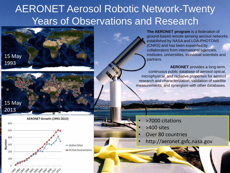
AERONET Aerosol Robotic Network-Twenty
Years of Observations and Research
AERONET provides a long-term,
continuous public database of aerosol optical,
microphysical, and radiative properties for aerosol
research and characterization, validation of satellite
measurements, and synergism with other databases.
The AERONET program is a federation of
ground-based remote sensing aerosol networks
established by NASA and LOA-PHOTONS
(CNRS) and has been expanded by
collaborators from international agencies,
institutes, universities, individual scientists and
partners. 15 May 1993
15 May 2013
• >7000 citations • >400 sites • Over 80 countries • http://aeronet.gsfc.nasa.gov
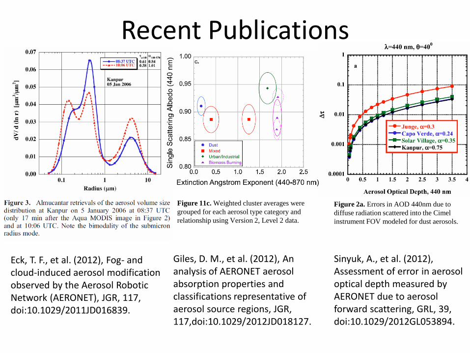
Recent Publications
Eck, T. F., et al. (2012), Fog- and cloud-induced aerosol modification observed by the Aerosol Robotic Network (AERONET), JGR, 117, doi:10.1029/2011JD016839.
Giles, D. M., et al. (2012), An analysis of AERONET aerosol absorption properties and classifications representative of aerosol source regions, JGR, 117,doi:10.1029/2012JD018127.
Figure 2a. Errors in AOD 440nm due to
diffuse radiation scattered into the Cimel
instrument FOV modeled for dust aerosols.
Figure 11c. Weighted cluster averages were
grouped for each aerosol type category and
relationship using Version 2, Level 2 data.
Sinyuk, A., et al. (2012), Assessment of error in aerosol optical depth measured by AERONET due to aerosol forward scattering, GRL, 39, doi:10.1029/2012GL053894.
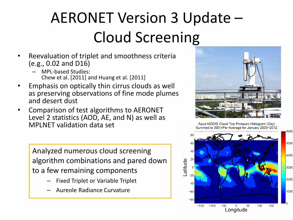
AERONET Version 3 Update – Cloud Screening
• Reevaluation of triplet and smoothness criteria (e.g., 0.02 and D16) – MPL-based Studies:
Chew et al. [2011] and Huang et al. [2011]
• Emphasis on optically thin cirrus clouds as well as preserving observations of fine mode plumes and desert dust
• Comparison of test algorithms to AERONET Level 2 statistics (AOD, AE, and N) as well as MPLNET validation data set
Analyzed numerous cloud screening algorithm combinations and pared down to a few remaining components
– Fixed Triplet or Variable Triplet
– Aureole Radiance Curvature
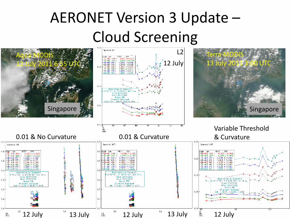
AERONET Version 3 Update – Cloud Screening
Terra MODIS 13 July 2011 3:00 UTC
Aqua MODIS 12 July 2011 6:55 UTC
L2
0.01 & No Curvature 0.01 & Curvature Variable Threshold & Curvature
12 July 12 July 12 July 13 July 13 July
12 July
Singapore Singapore
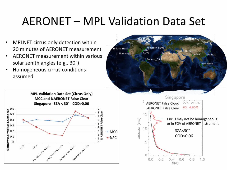
AERONET – MPL Validation Data Set
• MPLNET cirrus only detection within 20 minutes of AERONET measurement
• AERONET measurement within various solar zenith angles (e.g., 30°)
• Homogeneous cirrus conditions assumed
AERONET False Clear
AERONET False Cloud
SZA<30° COD>0.06
Cirrus may not be homogeneous or in FOV of AERONET instrument
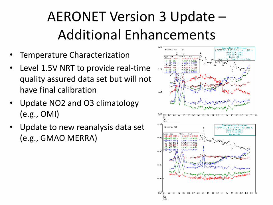
AERONET Version 3 Update – Additional Enhancements
• Temperature Characterization
• Level 1.5V NRT to provide real-time quality assured data set but will not have final calibration
• Update NO2 and O3 climatology (e.g., OMI)
• Update to new reanalysis data set (e.g., GMAO MERRA)
AERONET Version 3 Update Sky Retrievals
• Possible Principal Plane Retrievals
• Lidar and Depolarization Ratios
• Implementation of a vector radiative transfer code
– radiation field in UV (e.g., 380 nm retrieval)
– degree of linear depolarization
• Uncertainty estimates for each retrieval (e.g., random error plus biases due uncertainty in AOD and sky radiance calibration)
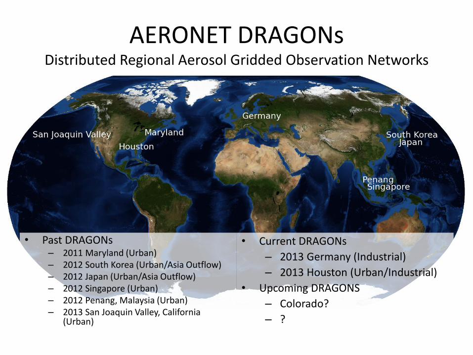
AERONET DRAGONs Distributed Regional Aerosol Gridded Observation Networks
• Past DRAGONs – 2011 Maryland (Urban) – 2012 South Korea (Urban/Asia Outflow) – 2012 Japan (Urban/Asia Outflow) – 2012 Singapore (Urban) – 2012 Penang, Malaysia (Urban) – 2013 San Joaquin Valley, California
(Urban)
• Current DRAGONs
– 2013 Germany (Industrial)
– 2013 Houston (Urban/Industrial)
• Upcoming DRAGONS
– Colorado?
– ?
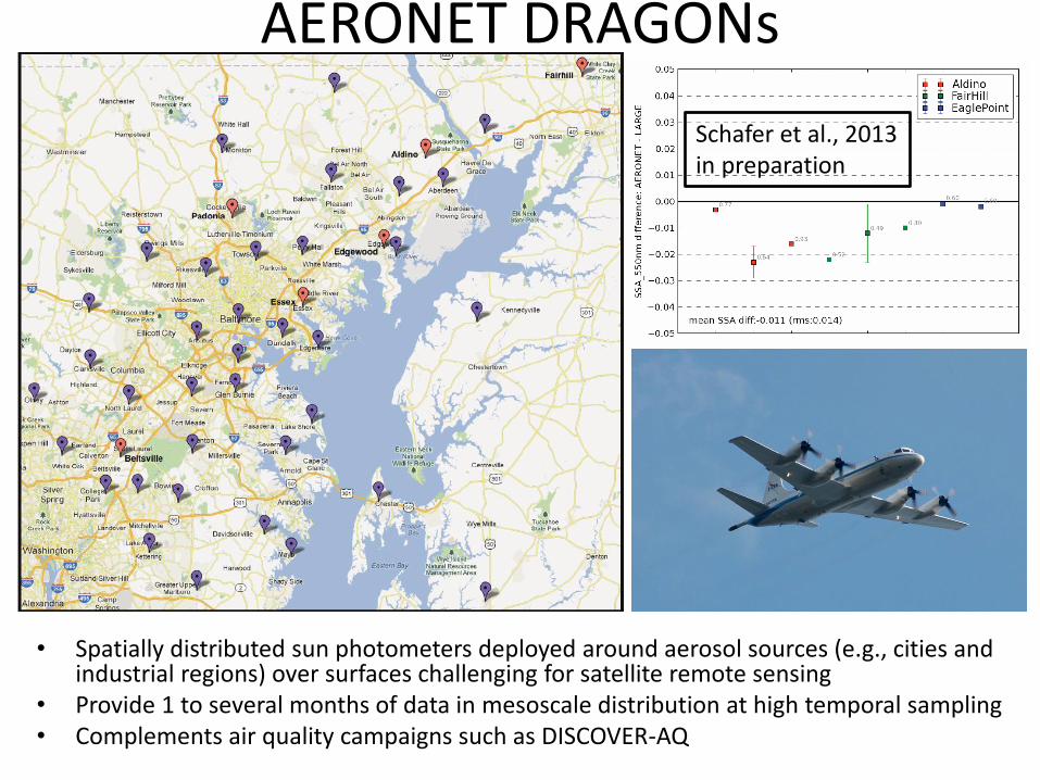
AERONET DRAGONs
• Spatially distributed sun photometers deployed around aerosol sources (e.g., cities and industrial regions) over surfaces challenging for satellite remote sensing
• Provide 1 to several months of data in mesoscale distribution at high temporal sampling • Complements air quality campaigns such as DISCOVER-AQ
Schafer et al., 2013 in preparation
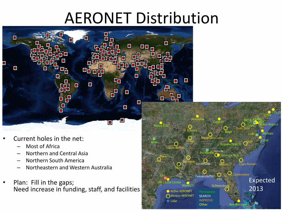
AERONET Distribution
• Current holes in the net: – Most of Africa – Northern and Central Asia – Northern South America – Northeastern and Western Australia
• Plan: Fill in the gaps; Need increase in funding, staff, and facilities
Permanent SEARCH IMPROVE Other
Expected 2013
AERONET New Instrumentation/Enhancements
• Greater control over instrument measurement scenarios (e.g., Hybrid)
• Additional capabilities such as SD card storage, GPS, USB, and Zigbee
• Development toward attachment for CO2 measurements
• Synergism with MPLNET, PANDORA, and in situ measurements
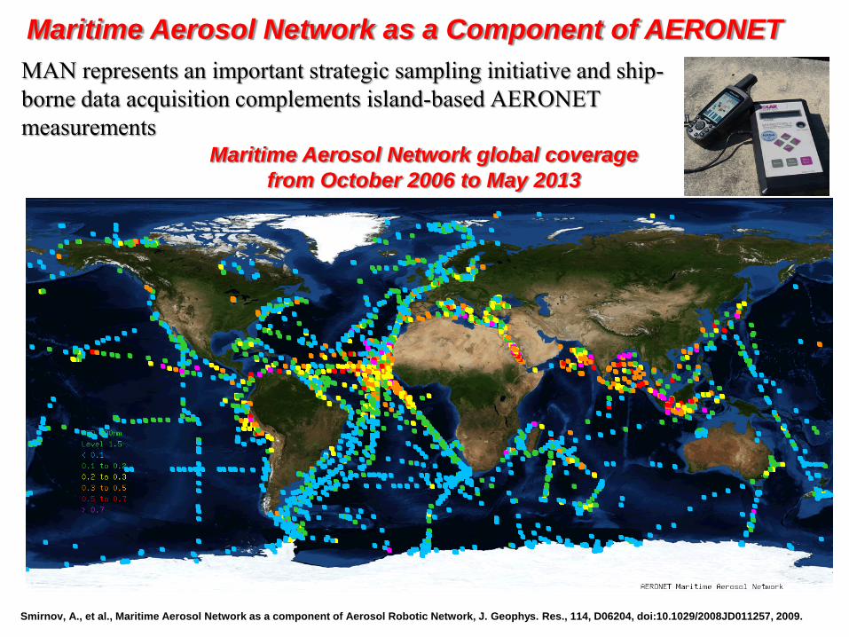
Maritime Aerosol Network global coverage
from October 2006 to May 2013
Maritime Aerosol Network as a Component of AERONET
Smirnov, A., et al., Maritime Aerosol Network as a component of Aerosol Robotic Network, J. Geophys. Res., 114, D06204, doi:10.1029/2008JD011257, 2009.
MAN represents an important strategic sampling initiative and ship-
borne data acquisition complements island-based AERONET
measurements
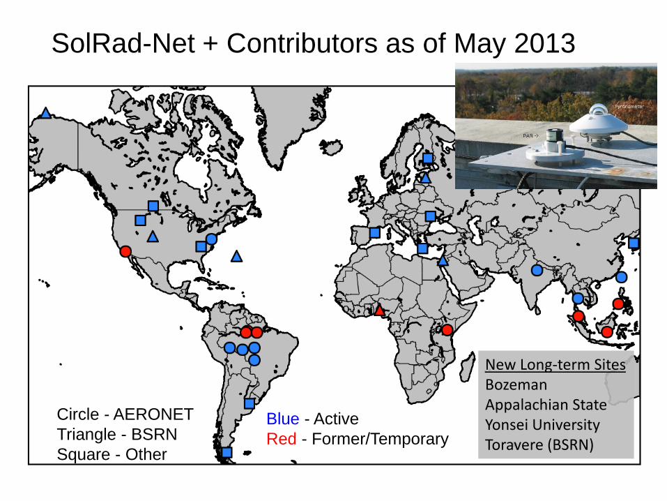
SolRad-Net + Contributors as of May 2013
Circle - AERONET
Triangle - BSRN
Square - Other
Blue - Active
Red - Former/Temporary
New Long-term Sites Bozeman Appalachian State Yonsei University Toravere (BSRN)
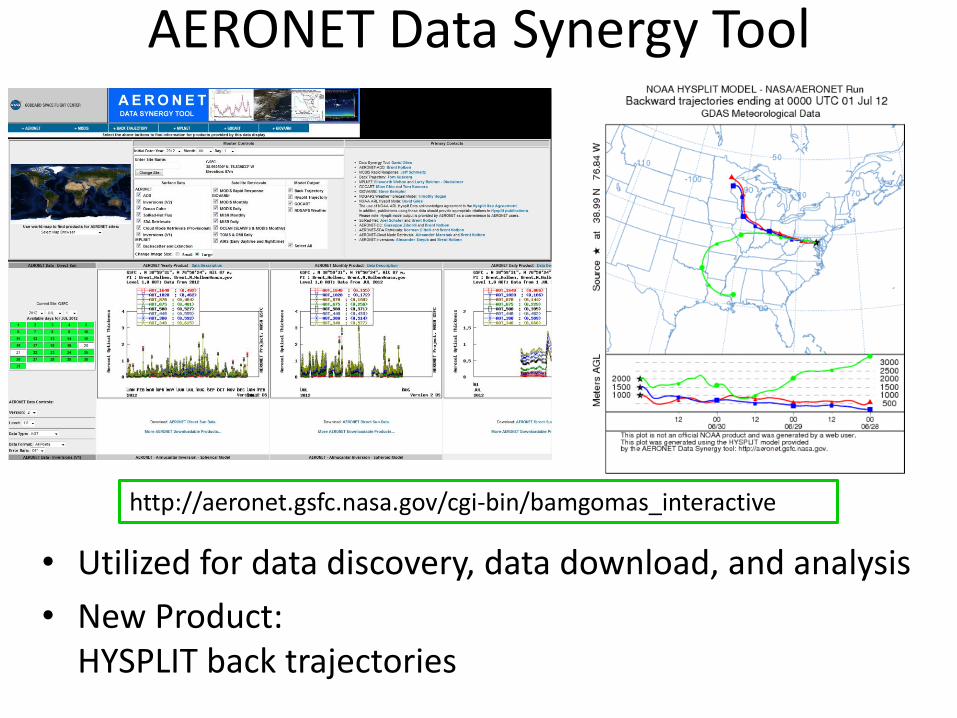
AERONET Data Synergy Tool
• Utilized for data discovery, data download, and analysis
• New Product: HYSPLIT back trajectories
http://aeronet.gsfc.nasa.gov/cgi-bin/bamgomas_interactive

Micro-Pulse Lidar Network (MPLNET)
Principal Investigator: Judd Welton, NASA GSFC Code 612
Instrumentation & Network Management:
Sebastian Stewart, SSAI GSFC Code 612 Phillip Haftings, SSAI GSFC Code 612
Data Processing & Research:
Larry Belcher, SSAI GSFC Code 612 James Campbell, Naval Research Lab Jasper Lewis, UMBC GSFC Code 612 Simone Lolli, UMBC GSFC Code 612
Administrative Support:
Erin Lee, SSAI GSFC Code 612
CALIPSO Validation Activities: Judd Welton, James Campbell
AERONET & Synergy Tool Partnership: Brent Holben, NASA GSFC Code 614.4
Dave Giles, NASA GSFC Code 614.4
NASA SMARTLABS Field Deployments: Si-Chee Tsay, NASA GSFC Code 613
Jack Ji, UMCP GSFC Code 613
Site Operations & Science Investigations …. many network partners around the world
MPLNET is funded by the NASA Radiation Sciences
Program and the Earth Observing System
MPLNET information and results shown here are the result of efforts by all of our network partners!
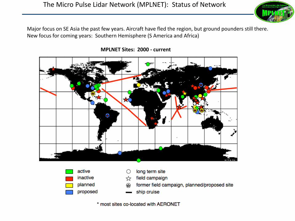
Micro-Pulse Lidar Network (MPLNET) The Micro Pulse Lidar Network (MPLNET): Status of Network
MPLNET Sites: 2000 - current
Major focus on SE Asia the past few years. Aircraft have fled the region, but ground pounders still there. New focus for coming years: Southern Hemisphere (S America and Africa)
Name Location, Partner Network
Status
Lida
r
1 EPA-NCU Taiwan, NCU Permanent MPL
2 Hanoi Vietnam, VAST Permanent MPL
3 Kanpur India, ITT Permanent MPL
4 Singapore Singapore, NUS Permanent MPL
5 Bac Lieu Vietnam, VAST Temporary ALS
6 Penang Malaysia, USM Temporary MPL
7 Kuching Malaysia, NUS/MMD Temporary
✗
ALS
8 Jambi Indonesia, BMKG Temporary
✗
ALS
9 Jakarta Indonesia, BMKG Temporary
✗
ALS
10 Palangkaraya Indonesia, BMKG Temporary
✗
ALS
11 Nepal Nepal, U Virginia Temporary ALS
12 RV Vasco Ship, NRL/Manila O. Temporary ALS
- Hong Kong Hong Kong, PolyU Pending * ALS ✗ International agreement not final
* Hong Kong group operates their own ALS lidar. They are not part of MPLNET due to current ban on bi-lateral NASA-China interactions
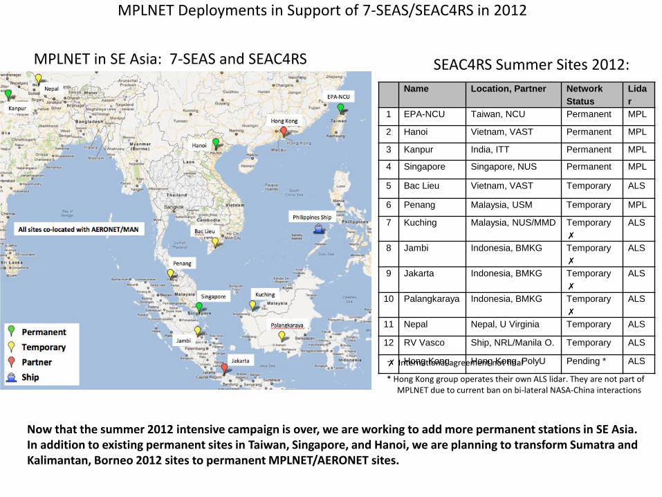
MPLNET in SE Asia: 7-SEAS and SEAC4RS SEAC4RS Summer Sites 2012:
MPLNET Deployments in Support of 7-SEAS/SEAC4RS in 2012
Now that the summer 2012 intensive campaign is over, we are working to add more permanent stations in SE Asia. In addition to existing permanent sites in Taiwan, Singapore, and Hanoi, we are planning to transform Sumatra and Kalimantan, Borneo 2012 sites to permanent MPLNET/AERONET sites.
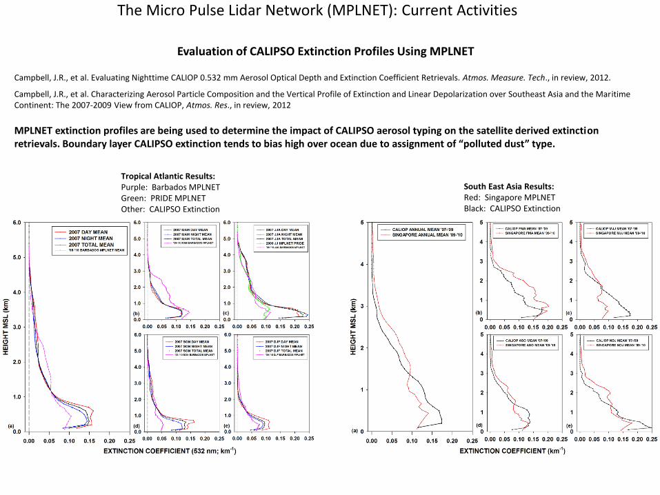
Evaluation of CALIPSO Extinction Profiles Using MPLNET Campbell, J.R., et al. Evaluating Nighttime CALIOP 0.532 mm Aerosol Optical Depth and Extinction Coefficient Retrievals. Atmos. Measure. Tech., in review, 2012.
Campbell, J.R., et al. Characterizing Aerosol Particle Composition and the Vertical Profile of Extinction and Linear Depolarization over Southeast Asia and the Maritime Continent: The 2007-2009 View from CALIOP, Atmos. Res., in review, 2012
MPLNET extinction profiles are being used to determine the impact of CALIPSO aerosol typing on the satellite derived extinction retrievals. Boundary layer CALIPSO extinction tends to bias high over ocean due to assignment of “polluted dust” type.
Tropical Atlantic Results: Purple: Barbados MPLNET Green: PRIDE MPLNET Other: CALIPSO Extinction
South East Asia Results: Red: Singapore MPLNET Black: CALIPSO Extinction
The Micro Pulse Lidar Network (MPLNET): Current Activities
(b) (c)
The Micro Pulse Lidar Network (MPLNET): Current Activities
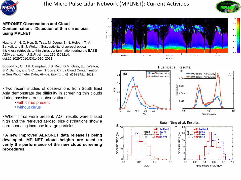
AERONET Observations and Cloud
Contamination: Detection of thin cirrus bias
using MPLNET
Huang, J., N. C. Hsu, S. Tsay, M. Jeong, B. N. Holben, T. A.
Berkoff, and E. J. Welton. Susceptibility of aerosol optical
thickness retrievals to thin cirrus contamination during the BASE-
ASIA campaign, J.G.R. Atmos., 116, D08214,
doi:10.1029/2010JD014910, 2011.
Boon-Ning, C., J.R. Campbell, J.S. Reid, D.M. Giles, E.J. Welton,
S.V. Santos, and S.C. Liew: Tropical Cirrus Cloud Contamination
in Sun Photometer Data, Atmos. Environ., 45, 6724-6731, 2011.
Huang et al. Results:
Boon-Ning et al. Results:
• Two recent studies of observations from South East Asia demonstrate the difficulty in screening thin clouds during passive aerosol observations.
• with cirrus present • without cirrus
• When cirrus were present, AOT results were biased high and the retrieved aerosol size distributions show a corresponding increase in large particles. • A new improved AERONET data release is being developed. MPLNET cloud heights are used to verify the performance of the new cloud screening procedures.
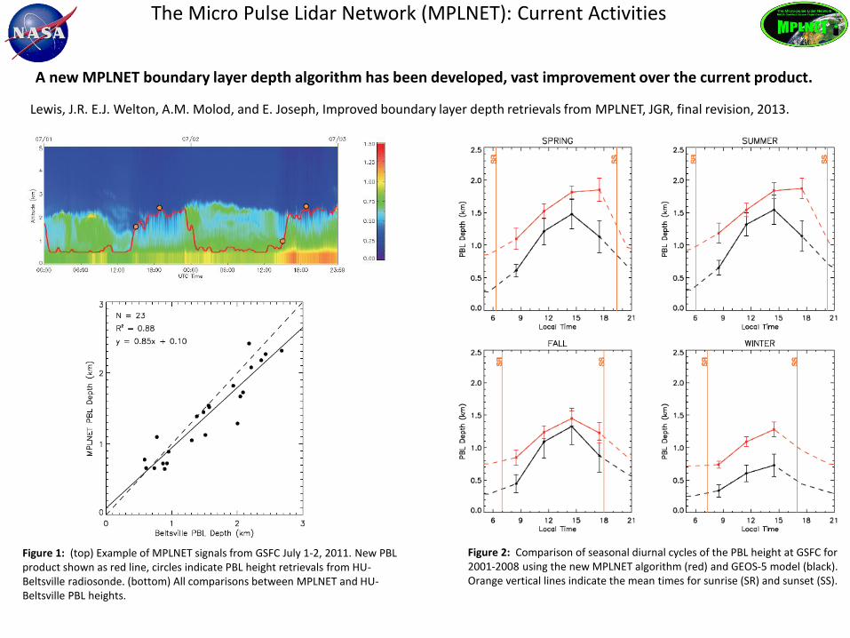
Lewis, J.R. E.J. Welton, A.M. Molod, and E. Joseph, Improved boundary layer depth retrievals from MPLNET, JGR, final revision, 2013.
A new MPLNET boundary layer depth algorithm has been developed, vast improvement over the current product.
Figure 2: Comparison of seasonal diurnal cycles of the PBL height at GSFC for 2001-2008 using the new MPLNET algorithm (red) and GEOS-5 model (black). Orange vertical lines indicate the mean times for sunrise (SR) and sunset (SS).
MPLNET (new) MPLNET (old)
The Micro Pulse Lidar Network (MPLNET): Current Activities
Figure 1: (top) Example of MPLNET signals from GSFC July 1-2, 2011. New PBL product shown as red line, circles indicate PBL height retrievals from HU-Beltsville radiosonde. (bottom) All comparisons between MPLNET and HU-Beltsville PBL heights.
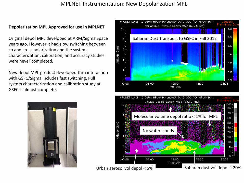
MPLNET Instrumentation: New Depolarization MPL
Depolarization MPL Approved for use in MPLNET Original depol MPL developed at ARM/Sigma Space years ago. However it had slow switching between co and cross polarization and the system characterization, calibration, and accuracy studies were never completed. New depol MPL product developed thru interaction with GSFC/Sigma includes fast switching. Full system characterization and calibration study at GSFC is almost complete.
Saharan Dust Transport to GSFC in Fall 2012
Urban aerosol vol depol < 5% Saharan dust vol depol ~ 20%
Molecular volume depol ratio < 1% for MPL
No water clouds
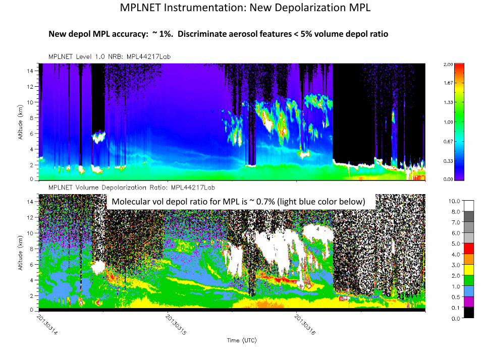
MPLNET Instrumentation: New Depolarization MPL
New depol MPL accuracy: ~ 1%. Discriminate aerosol features < 5% volume depol ratio
Molecular vol depol ratio for MPL is ~ 0.7% (light blue color below)
Adding Depolarization Lidars to MPLNET
Development has started on our Version 3 Data release (with new website) • Several new products: new PBL height, depolarization • Improved high cloud/cirrus retrievals • Enhanced, better performing continuous day/night aerosol retrievals • More efficient data file search, request, delivery • More online tools for data visualization
Working to develop an automated QC/QA tool for MPLNET verification of aerosol models (GEOS-5, NAAPS, etc).
The Micro Pulse Lidar Network (MPLNET): Summary