Embed Size (px)
Citation preview

2016-11-17 PNP-LGS-Draft-5-v2-Low Res (To Forum) Page 1 of 81
Local Green Space Designation
--------------
Abbreviations used in this draft
Abt About B Blatchcome CP Area Community Partnership Area C+M Clifton with Maidenway GR+H Goodrington with Roseland and Hookhills ha Hectare (1 ha = approx 2.47 acres) LGS Local Green Space N North NP Neighbourhood Plan NPPF National Planning Policy Framework PPG Planning Policy Guidance PLGS Paignton Local Green Space Pres Preston PT Paignton Town Centre ULPA Urban Landscape Protection Area < Less than
DRAFT 5
This draft shows the outcome of the Forum meeting on 20 October 2016.
The next step involves putting the information into the Neighbourhood Plan and
Supporting Evidence drafts subject to any further Forum views on the response received from Torbay Council in the separate schedule

2016-11-17 PNP-LGS-Draft-5-v2-Low Res (To Forum) Page 2 of 81
Local Green Space Designations Background
X.1 The National Planning Policy Framework enables Local Green Space (LGS) to be designated when making a Local Plan or Neighbourhood Plan. X.2 The new Torbay Local Plan adopted by the Council on 10 December 2015 left identification and designation of LGS for the Neighbourhood Plan to determine (Local
Plan paragraph 6.3.1.37).
X.3 Accordingly, the information below shows the criteria applied, how the assessment has been carried out, and outcome in arriving at the sites proposed for designation in the Neighbourhood Plan:
a) The National Planning Policy Framework (NPPF) b) Planning Practice Guidance (PPG) c) Torbay Local Plan 2012-30 Policy C5 (Urban Landscape Protection Areas) d) Assessment method adopted e) Summary results for each site
X.4 For ease of reference, extracts of the PPG are shown in Appendix XX. X.5 In accordance with PPG 019 land owners have been provided with the opportunity to comment on the proposed designations which affect their land. [insert
date and response]
Policy context
a) National Planning Policy Framework
X.6 The NPPF sets out the purpose of LGS designation and criteria applicable:- NPPF76 Local communities through local and neighbourhood plans should be able to
identify for special protection green areas of particular importance to them. By
designating land as Local Green Space local communities will be able to rule out new
development other than in very special circumstances. Identifying land as Local
Green Space should therefore be consistent with the local planning of sustainable
development and complement investment in sufficient homes, jobs and other
essential services. Local Green Spaces should only be designated when a plan is prepared or reviewed, and be capable of enduring beyond the end of the plan period.
NPPF77 The Local Green Space designation will not be appropriate for most green areas or open space. The designation should only be used:
● where the green space is in reasonably close proximity to the community it serves;
● where the green area is demonstrably special to a local community and
holds a particular local significance, for example because of its beauty,
historic significance, recreational value (including as a playing field), tranquility or richness of its wildlife; and
● where the green area concerned is local in character and is not an extensive
tract of land.
NPPF78 Local policy for managing development within a Local Green Space should
be consistent with policy for Green Belts.

2016-11-17 PNP-LGS-Draft-5-v2-Low Res (To Forum) Page 3 of 81
NPPF79 The Government attaches great importance to Green Belts. The
fundamental aim of Green Belt policy is to prevent urban sprawl by keeping land
permanently open; the essential characteristics of Green Belts are their openness
and their permanence b) Planning Practice Guidance
X.7 Further detail on the purpose and scope of assessment required to be applied is contained in the government internet based PPG as shown in Appendix XX attached. c) Torbay Local Plan
X.8 Local Plan Policy C5 identifies a number of Urban Landscape Protection Areas (ULPA) where the purpose is to protect the essential landscape features of these areas (Local Plan paragraph 6.3.1.36) and recognises they may also qualify for designation as Local Green Space in the Neighbourhood Plan (Local Plan paragraph
6.3.1.37). X.9 Each has a unique ULPA number in the policy text and C5 reference number on the policy map (Table X.1 below). Each has been included in the Neighbourhood Plan assessment as intended by the Local Plan. Table X.1 – Local Plan Urban Landscape Protection Areas (Paignton)
ULPA Ref Site name Policy Map Ref
ULPA 33 Preston Green C5.33 ULPA 34 Parkfield C5.34 ULPA 35 Paignton Green North C5.35 ULPA 36 Paignton Green South C5.36 ULPA 37 Queen’s Park C5.37 ULPA 38 Victoria Park C5.38 ULPA 39 Paignton Cemetery and allotments C5.39 ULPA 40 Monastery, Winner Hill C5.40 ULPA 41 Primley Woods and Meadow to south C5.41 ULPA 42 Goodrington Park/Roundham C5.42 ULPA 43 Quay West Corner C5.43 ULPA 44 Clennon Hill/Roselands Valley C5.44 ULPA 45 Sugar Loaf Hill C5.45 ULPA 46 Waterside, Goodrington C5.46
Source: Local Plan Policy C5 and Policies Map booklet
d) Assessment method adopted
X.10 The assessment involved three stages to ensure a robust approach: Stage 1 – a list of sites was drawn up by Forum members from across the whole of the Neighbourhood Plan area for addition to those in Policy C5 of the Local Plan; Stage 2 – an initial desk top assessment by Forum volunteers was undertaken of each site in comparison with the NPPF and PPG criteria; Stage 3 – a more detailed review was undertaken by Forum volunteers together with site inspection and boundary definition to ensure consistency of approach and

2016-11-17 PNP-LGS-Draft-5-v2-Low Res (To Forum) Page 4 of 81
compliance with the criteria for designation, and the results considered by the Forum as a whole before proceeding further. X.10 In Stage 2, Local Plan defined sites ULPA 45 / C5.45 (Sugar Loaf Hill) and ULPA 46 / C5.46 (Waterside) were eliminated as they were found to lie within the Brixham Neighbourhood Plan area. X.11 In Stage 3 a number of site boundary refinements were made to ensure compliance with the defined criteria. In some cases the boundaries of the ULPA and LGS do not coincide due to the difference in criteria applying to each. X.12 Following completion of Stage 3, the results were shared with the Council for comment in accordance with the advice of PPG066. [insert response under PPG067]
d) Summary results
X.13 In accordance with NPPF and PPG requirements, every Local Green Space proposed in the Neighbourhood Plan meets the following criteria (see Table X.2): Table X.2 – Local Green Space Criteria
Criteria source Assessment made
NPPF76; PPG007; PPG008
The space is not subject to planning permission that prevents designation, is not allocated for development in the Torbay Local Plan or proposed Neighbourhood Plan, and designation is capable of enduring beyond the plan period.
NPPF77; PPG014; PPG015
The space is in reasonably close proximity to the community it serves, local in character and is not an extensive tract of land
NPPF77; PPG009; PPG010; PPG011; PPG012; PPG013
The space is demonstrably special to the community it serves by meeting one or more of the following criteria:
• beauty • historical significance • recreation value • tranquility • richness of wildlife • other specified reason
X.14 Schedule X.1 below shows a summary of the Stage 1 results. The sheets in Schedule X.2 provide further information about each site including a location plan of the proposed designation boundary and photograph for identification purposes. X.15 Where wildlife interest was involved the following references were also taken into account for corroboration where shown in the summary schedules: References:
(1) The Torbay Biodiversity Steering Group, 2006, The Nature of Torbay: A local
Biodiversity and Geodiversity Action Plan 2006-2016, Summary Document, Nature Conservation Sites in Torbay: Table 1, pp. 7-9 and Map, pp. 14-15.

2016-11-17 PNP-LGS-Draft-5-v2-Low Res (To Forum) Page 5 of 81
(2) Torbay Council, Natural England and Torbay Coast and Countryside Trust, April 2011, The Torbay Green Infrastructure Delivery Plan: Building a
Sustainable Future for Torbay, Climate Change and Water Quality, pp. 22-25.
(3) Torbay Council, Natural England and Torbay Coast and Countryside Trust, April 2011, The Torbay Green Infrastructure Delivery Plan: Building a
Sustainable Future for Torbay, 4.2 Cockington and Occombe, pp. 29-31.
(4) Torbay Council, Natural England and Torbay Coast and Countryside Trust, April 2011, The Torbay Green Infrastructure Delivery Plan: Building a
Sustainable Future for Torbay, 4.3 Paignton, pp. 32-34.
(5) Torbay Council, Natural England and Torbay Coast and Countryside Trust, April 2011, The Torbay Green Infrastructure Delivery Plan: Building a
Sustainable Future for Torbay, 2 Vision and Aims – Map1. Green Infrastructure Master Plan, pp. 8.
(6) Torbay Council, Natural England and Torbay Coast and Countryside Trust,
April 2011, The Torbay Green Infrastructure Delivery Plan: Building a
Sustainable Future for Torbay, Strategic Recreation, Travel and Health Delivery, pp. 10-12.
(7) Torbay Council, Natural England and Torbay Coast and Countryside Trust,
April 2011, The Torbay Green Infrastructure Delivery Plan: Building a
Sustainable Future for Torbay, 3.3 Local Food, pp. 18-21. X.16 The designations proposed in the Neighbourhood Plan are shown in Table X.3 and by location in Fig X.1 below starting with the Town Centre area and working outwards geographically.
Table X.3 Local Green Space designations proposed
NP Ref Site name CP Area
PT
Pre
s
C+
M
GR+
H
B
PLGS.01 Paignton Green � PLGS.02 Victoria Park � PLGS.03 Torbay Park and Gardens � PLGS.04 Berry Square � PLGS.05 Queens Park (private) � PLGS.06 Palace Avenue Gardens � PLGS.07 Burma Star Garden � PLGS.08 Whitstone Corner � PLGS.09 Roundham Head Park � PLGS.10 St Michael’s Field � PLGS.11 Oakleigh Allotments � PLGS.12 Derrell Road Allotments � PLGS.13 Preston Green � PLGS.14 Parkfield � PLGS.15 Coombe Valley Park � PLGS.16 Hollicombe Cliff Park � PLGS.17 Hollicombe Park (part of) � PLGS.18 Wills Avenue Playground � PLGS.19 Preston Gardens �
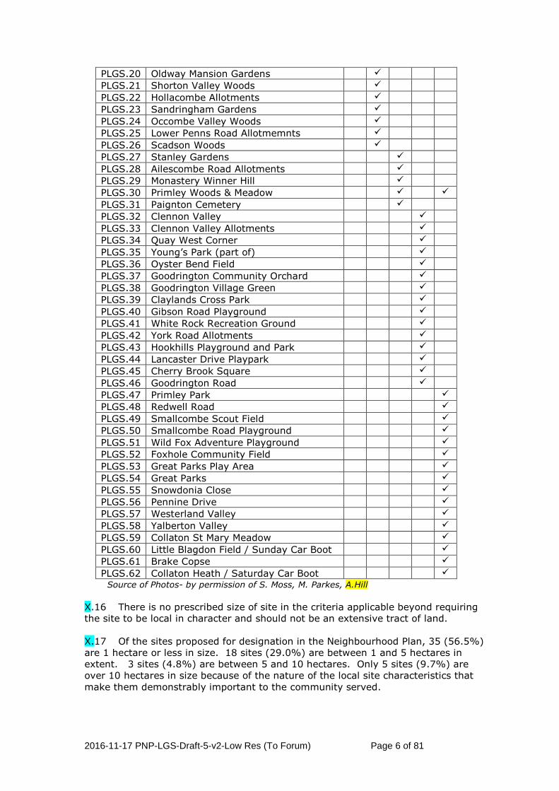
2016-11-17 PNP-LGS-Draft-5-v2-Low Res (To Forum) Page 6 of 81
PLGS.20 Oldway Mansion Gardens � PLGS.21 Shorton Valley Woods � PLGS.22 Hollacombe Allotments � PLGS.23 Sandringham Gardens � PLGS.24 Occombe Valley Woods � PLGS.25 Lower Penns Road Allotmemnts � PLGS.26 Scadson Woods � PLGS.27 Stanley Gardens � PLGS.28 Ailescombe Road Allotments � PLGS.29 Monastery Winner Hill � PLGS.30 Primley Woods & Meadow � �
PLGS.31 Paignton Cemetery � PLGS.32 Clennon Valley � PLGS.33 Clennon Valley Allotments � PLGS.34 Quay West Corner � PLGS.35 Young’s Park (part of) � PLGS.36 Oyster Bend Field � PLGS.37 Goodrington Community Orchard � PLGS.38 Goodrington Village Green � PLGS.39 Claylands Cross Park � PLGS.40 Gibson Road Playground � PLGS.41 White Rock Recreation Ground � PLGS.42 York Road Allotments � PLGS.43 Hookhills Playground and Park � PLGS.44 Lancaster Drive Playpark � PLGS.45 Cherry Brook Square � PLGS.46 Goodrington Road � PLGS.47 Primley Park �
PLGS.48 Redwell Road �
PLGS.49 Smallcombe Scout Field �
PLGS.50 Smallcombe Road Playground �
PLGS.51 Wild Fox Adventure Playground �
PLGS.52 Foxhole Community Field �
PLGS.53 Great Parks Play Area �
PLGS.54 Great Parks �
PLGS.55 Snowdonia Close �
PLGS.56 Pennine Drive �
PLGS.57 Westerland Valley �
PLGS.58 Yalberton Valley �
PLGS.59 Collaton St Mary Meadow �
PLGS.60 Little Blagdon Field / Sunday Car Boot �
PLGS.61 Brake Copse �
PLGS.62 Collaton Heath / Saturday Car Boot � Source of Photos- by permission of S. Moss, M. Parkes, A.Hill
X.16 There is no prescribed size of site in the criteria applicable beyond requiring the site to be local in character and should not be an extensive tract of land. X.17 Of the sites proposed for designation in the Neighbourhood Plan, 35 (56.5%) are 1 hectare or less in size. 18 sites (29.0%) are between 1 and 5 hectares in extent. 3 sites (4.8%) are between 5 and 10 hectares. Only 5 sites (9.7%) are over 10 hectares in size because of the nature of the local site characteristics that make them demonstrably important to the community served.

2016-11-17 PNP-LGS-Draft-5-v2-Low Res (To Forum) Page 7 of 81
Fig X.1: Local Green Spaces
Town Centre
PLGS.01
PLGS.02
PLGS.03 PLGS.05
PLGS.06
PLGS.14
PLGS.07
PLGS.09
PLGS.10
PLGS.11
PLGS.15
PLGS.16
PLGS.20
PLGS.21
PLGS.22
PLGS.23PLGS.27
PLGS.28
PLGS.29
PLGS.30
PLGS.32
PLGS.33
PLGS.34
PLGS.35
PLGS.36
PLGS.38
PLGS.37 PLGS.39
PLGS.40 PLGS.41
Town
Centre Inset
PLGS.42
PLGS.47
PLGS.48 PLGS.57
PLGS.58
PLGS.58
PLGS.60
PLGS.62
PLGS.43
PLGS.61
PLGS.31
PLGS.19
PLGS.25
PLGS.26 PLGS.24
PLGS.17
PLGS.12
PLGS.18
PLGS.13
PLGS.46
PLGS.45
PLGS.44
PLGS.56
PLGS.55
PLGS.53
PLGS.54
PLGS.51
PLGS.50 PLGS.49
PLGS.08
PLGS.04
PLGS.52

2016-11-17 PNP-LGS-Draft-5-v2-Low Res (To Forum) Page 8 of 81
Schedule X.1: Stage 1 Summary
Criteria source
Assessment made PLGS.01 Paignton Green
PLGS.02 Victoria Park
PLGS.03 Torbay Park & Gardens
PLGS.04 Berry Square
PLGS.05 Queens Park
PLGS.06 Palace Ave Gardens
PLGS.07 Burma Star Garden
PLGS.08 Whitstone Corner
PLGS.09 Roundam Head Park
The space is:
• not subject to planning permission that prevents designation
√
√
√
√
√
√
√
√
√
• not allocated for development in the Torbay Local Plan or proposed Neighbourhood Plan
√ √ √ √ √ √ √ √ √
NPPF76;PPG007; PPG008
• capable of enduring beyond the plan period.
√ √ √ √ √ √ √ √ √
• in reasonably close proximity to the community it serves
√ √ √ √ √ √ √ √ √
• local in character √ √ √ √ √ √ √ √ √
NPPF77; PPG014; PPG015
• not an extensive tract of land Abt 5 ha Abt 7 ha <1 ha <1 ha Abt 3 ha <1 ha <1 ha <1 ha Abt 3 ha
• demonstrably special to the community it serves for its:
√ √ √ √ √ √ √ √ √
• beauty √ √ √ √
• historical significance √ √ √ √ √ √
• recreation value √ √ √ √ √ √ √ √ √
• tranquility √ √ √ √ √
NPPF77; PPG009; PPG010; PPG011; PPG012; PPG013
• richness of wildlife √ √ √

2016-11-17 PNP-LGS-Draft-5-v2-Low Res (To Forum) Page 9 of 81
Criteria source
Assessment made PLGS.10 St. Michaels Field
PLGS.11 Oakleigh Allotments
PLGS.12 Derrell Road Allotments
PLGS.13 Preston Green
PLGS.14 Parkfield
PLGS.15 Coombe Valley Park
PLGS.16 Hollicombe Cliff Park
PLGS.17 Hollicombe Park (part of)
PLGS.18 Wills Ave Playground
The space is:
• not subject to planning permission that prevents designation
√
√
√
√
√
√
√
√
√
• not allocated for development in the Torbay Local Plan or proposed Neighbourhood Plan
√ √ √ √ √ √ √ √ √
NPPF76;PPG007; PPG008
• capable of enduring beyond the plan period.
√ √ √ √ √ √ √ √ √
• in reasonably close proximity to the community it serves
√ √ √ √ √ √ √ √ √
• local in character √ √ √ √ √ √ √ √ √
NPPF77; PPG014; PPG015
• not an extensive tract of land <1 ha <2 ha <1 ha Abt 3 ha <2 ha <1 ha < 1 ha <1 ha <1 ha
• demonstrably special to the community it serves for its:
√ √ √ √ √ √ √ √ √
• beauty √ √ √
• historical significance √ √ √
• recreation value √ √ √ √ √ √ √ √ √
• tranquility √ √ √ √ √ √
NPPF77; PPG009; PPG010; PPG011; PPG012; PPG013
• richness of wildlife √ √ √ √ √ √ √

2016-11-17 PNP-LGS-Draft-5-v2-Low Res (To Forum) Page 10 of 81
Criteria source
Assessment made PLGS.19 Preston Gardens
PLGS.20 Oldway Mansion Gardens
PLGS.21 Shorton Valley Woods
PLGS.22 Hollacombe Allotments
PLGS.23 Sandringham Gardens
PLGS.24 Occombe Valley Woods
PLGS.25 Lower Penns Rd Allotments
PLGS.26 Scadson Woods
PLGS.27 Stanley Gardens
The space is:
• not subject to planning permission that prevents designation
√
√
√
√
√
√
√
√
√
• not allocated for development in the Torbay Local Plan or proposed Neighbourhood Plan
√ √ √ √ √ √ √ √ √
NPPF76;PPG007; PPG008
• capable of enduring beyond the plan period.
√ √ √ √ √ √ √ √ √
• in reasonably close proximity to the community it serves
√ √ √ √ √ √ √ √ √
• local in character √ √ √ √ √ √ √ √ √
NPPF77; PPG014; PPG015
• not an extensive tract of land <1 ha Abt 8 ha Abt 1 ha <1 ha <1 ha Abt 37 ha <2 ha Abt 9 ha Abt 1 ha
• demonstrably special to the community it serves for its:
√ √ √ √ √ √ √ √ √
• beauty √ √ √ √ √ √ √
• historical significance √ √
• recreation value √ √ √ √ √ √ √ √ √
• tranquility √ √ √ √ √ √ √ √ √
NPPF77; PPG009; PPG010; PPG011; PPG012; PPG013
• richness of wildlife √ √ √ √ √ √

2016-11-17 PNP-LGS-Draft-5-v2-Low Res (To Forum) Page 11 of 81
Criteria source
Assessment made PLGS.28 Ailescombe Road Allotments
PLGS.29 Monastery Winner Hill
PLGS.30 Primley Woods & Meadow
PLGS.31 Paignton Cemetery
PLGS.32 Clennon Valley
PLGS.33 Clennon Valley Allotments
PLGS.34 Quay West Corner
PLGS.35 Youngs Park (part of)
PLGS.36 Oyster Bend Field
The space is:
• not subject to planning permission that prevents designation
√
√
√
√
√
√
√
√
√
• not allocated for development in the Torbay Local Plan or proposed Neighbourhood Plan
√ √ √ √ √ √ √ √ √
NPPF76;PPG007; PPG008
• capable of enduring beyond the plan period.
√ √ √ √ √ √ √ √ √
• in reasonably close proximity to the community it serves
√ √ √ √ √ √ √ √ √
• local in character √ √ √ √ √ √ √ √ √
NPPF77; PPG014; PPG015
• not an extensive tract of land Abt 1 ha Abt 1 ha Abt 13 ha Abt 4 ha Abt 67 ha Abt 1 ha Abt 1 ha Abt 3 ha Abt 2 ha
• demonstrably special to the community it serves for its:
√ √ √ √ √ √ √ √ √
• beauty √ √ √ √ √ √
• historical significance √ √ √
• recreation value √ √ √ √ √ √ √ √ √
• tranquility √ √ √ √ √ √ √ √ √
NPPF77; PPG009; PPG010; PPG011; PPG012; PPG013
• richness of wildlife √ √ √

2016-11-17 PNP-LGS-Draft-5-v2-Low Res (To Forum) Page 12 of 81
Criteria source
Assessment made PLGS.37 Goodrington Community Orchard
PLGS.38 Goodrington Village Green
PLGS.39 Claylands Cross Park
PLGS.40 Gibson Road Playground
PLGS.41 White Rock Rec. Ground
PLGS.42 York Road Allotments
PLGS.43 Hookhills Playpark
PLGS.44 Lancaster Drive Playpark
The space is:
• not subject to planning permission that prevents designation
√
√
√
√
√
√
√
√
• not allocated for development in the Torbay Local Plan or proposed Neighbourhood Plan
√ √ √ √ √ √ √ √
NPPF76;PPG007; PPG008
• capable of enduring beyond the plan period.
√ √ √ √ √ √ √ √
• in reasonably close proximity to the community it serves
√ √ √ √ √ √ √ √
• local in character √ √ √ √ √ √ √ √
NPPF77; PPG014; PPG015
• not an extensive tract of land <1 ha <1 ha <1 ha <1 ha Abt 2 ha Abt 2 ha Abt 1 ha <1 ha
• demonstrably special to the community it serves for its:
√ √ √ √ √ √ √ √
• beauty
• historical significance √
• recreation value √ √ √ √ √ √ √ √
• tranquility √ √ √ √ √ √ √
NPPF77; PPG009; PPG010; PPG011; PPG012; PPG013
• richness of wildlife √

2016-11-17 PNP-LGS-Draft-5-v2-Low Res (To Forum) Page 13 of 81
Criteria source
Assessment made PLGS.45 Cherry Brook Square
PLGS.46 Goodrington Road
PLGS.47 Primley Park
PLGS.48 Redwell Road
PLGS.49 Smallcombe Scout Field
PLGS.50 Smallcombe Road Playground
PLGS.51 Wild Fox Adventure Playgound
PLGS.52 Foxhole Community Field
The space is:
• not subject to planning permission that prevents designation
√
√
√
√
√
√
√
√
• not allocated for development in the Torbay Local Plan or proposed Neighbourhood Plan
√ √ √ √ √ √ √ √
NPPF76;PPG007; PPG008
• capable of enduring beyond the plan period.
√ √ √ √ √ √ √ √
• in reasonably close proximity to the community it serves
√ √ √ √ √ √ √ √
• local in character √ √ √ √ √ √ √ √
NPPF77; PPG014; PPG015
• not an extensive tract of land <1 ha Abt 2 ha Abt 2 ha <1 ha <1 ha <1 ha <1 ha Abt 1 ha
• demonstrably special to the community it serves for its:
√ √ √ √ √ √ √ √
• beauty √
• historical significance √ √
• recreation value √ √ √ √ √ √ √ √
• tranquility √ √ √
NPPF77; PPG009; PPG010; PPG011; PPG012; PPG013
• richness of wildlife √

2016-11-17 PNP-LGS-Draft-5-v2-Low Res (To Forum) Page 14 of 81
Criteria source
Assessment made PLGS.53 Great Parks Play Area
PLGS.54 Great Parks
PLGS.55 Snowdownia Close
PLGS.56 Pennine Drive
PLGS.57 Westerland Valley
PLGS.58 Yalberton Valley
PLGS.59 Collaton St. Mary Water Meadow
PLGS.60 Little Blagdon, Sunday Car Boot field
The space is:
• not subject to planning permission that prevents designation
√
√
√
√
√
√
√
√
• not allocated for development in the Torbay Local Plan or proposed Neighbourhood Plan
√ √ √ √ √ √ √ √
NPPF76;PPG007; PPG008
• capable of enduring beyond the plan period.
√ √ √ √ √ √ √ √
• in reasonably close proximity to the community it serves
√ √ √ √ √ √ √ √
• local in character √ √ √ √ √ √ √ √
NPPF77; PPG014; PPG015
• not an extensive tract of land <1 ha Abt 27 ha <1 ha <1 ha Abt 27 ha Abt 36 ha Abt 4 ha Abt 3 ha
• demonstrably special to the community it serves for its:
√ √ √ √ √ √ √ √
• beauty √ √ √ √ √
• historical significance √ √ √
• recreation value √ √ √ √ √ √ √ √
• tranquility √ √ √ √ √
NPPF77; PPG009; PPG010; PPG011; PPG012; PPG013
• richness of wildlife √ √ √ √ √

2016-11-17 PNP-LGS-Draft-5-v2-Low Res (To Forum) Page 15 of 81
Criteria source
Assessment made PLGS.61 Brake Copse
PLGS.62 Collaton Heath, Saturday Car Boot field
The space is:
• not subject to planning permission that prevents designation
√
√
• not allocated for development in the Torbay Local Plan or proposed Neighbourhood Plan
√ √
NPPF76;PPG007; PPG008
• capable of enduring beyond the plan period.
√ √
• in reasonably close proximity to the community it serves
√ √
• local in character √ √
NPPF77; PPG014; PPG015
• not an extensive tract of land <3 ha Abt 2 ha
• demonstrably special to the community it serves for its:
√ √
• beauty √
• historical significance √
• recreation value √ √
• tranquility √
NPPF77; PPG009; PPG010; PPG011; PPG012; PPG013
• richness of wildlife √

2016-11-17 PNP-LGS-Draft-5-v2-Low Res (To Forum) Page 16 of 81
Schedule X.2: Further information about each site
PLGS.01: Paignton Green North, Central and South Size: Abt 5 ha Ownership: Public
Community Partnership Area:
Paignton Town Centre (Roundham with Hyde Ward)
In reasonably close proximity to the community served:
Centrally located along town centre seafront.
Why demonstrably special to the community served:
Over 160 years community use for leisure and recreation. Covenant from Council to community over part of green restricting built development for 100 years.
Local in character:
Defined boundaries of long standing.
Other relevant information:
North and Central Green are designated as an Urban Landscape Protection Area C5.35 by Policy C5 of the Torbay Local Plan. Both parts of South Green are within C.36. Collectively these give protection of the landscape value only. Public toilets on North Green included but not commercial Cinema complex and Crazy Golf Course on South Green. Incorporates area previously known as Polsam Green in Victorian period.
N

2016-11-17 PNP-LGS-Draft-5-v2-Low Res (To Forum) Page 17 of 81
PLGS.02: Victoria Park, Torquay Road Size: Abt 7 ha Ownership: Public
Community Partnership Area:
Paignton Town Centre (Roundham with Hyde Ward)
In reasonably close proximity to the community served:
Located within urban area served
Why demonstrably special to the community served:
5,700 signature petition received from Paignton residents to protect park
Local in character:
Defined boundaries of long standing
Other relevant information:
Allocated as an Urban Landscape Protection Area (C5.38) by Policy C5 of the Torbay Local Plan giving protection of its landscape value only.

2016-11-17 PNP-LGS-Draft-5-v2-Low Res (To Forum) Page 18 of 81
PLGS.03: Torbay Park and Gardens, Esplanade Road Size: <1 ha Ownership: Public
Community Partnership Area:
Paignton Town Centre (Roundham with Hyde Ward)
In reasonably close proximity to the community served:
Centrally located within town centre
Why demonstrably special to the community served:
Historically important and commemorative informal green space used constantly by residents and tourists for over 100 years
Local in character:
Key part of town centre green space network
Other relevant information:
Within Core Tourism Investment Area T01/T02 of Local Plan. Designated as an Urban Landscape Protection Area (C.37) by Policy C5 of the Local Plan giving protection of its landscape value only. Military memorial on north east corner included in proposed LGS designation.

2016-11-17 PNP-LGS-Draft-5-v2-Low Res (To Forum) Page 19 of 81
PLGS.04: Berry Square, off Kernou Road Size: <1 ha Ownership: Private
Community Partnership Area:
Paignton Town (Roundham with Hyde Ward)
In reasonably close proximity to the community served:
Serves adjoining residential area and nearby hotel visitors.
Why demonstrably special to the community served:
Open area and green oasis continually used by local residents and holidaymakers for amenity and occasional car-parking.
Local in character:
Defined boundaries of long standing.
Other relevant information:
Within designated Community Investment Area of Local Plan. LGS designation will add protection of the green space recreation value.

2016-11-17 PNP-LGS-Draft-5-v2-Low Res (To Forum) Page 20 of 81
PLGS.05: Queens Park (Rugby & Cricket ground) Size: Abt 3 ha Ownership: Private
Community Partnership Area:
Paignton Town Centre (Roundham with Hyde Ward)
In reasonably close proximity to the community served:
Centrally located within town centre
Why demonstrably special to the community served:
Historically important green space used for town wide community events since Victorian times
Local in character:
Key part of town centre green space network
Other relevant information:
No consents for development. Allocated as an Urban Landscape Protection Area (C.37) by Policy C5 of Local Plan giving protection of its landscape value only. Also allocated for housing consideration in the Neighbourhood Plan but with flood and drainage constraints (see PNPH17). Bowling greens and club pavilions included in proposed LGS designation.

2016-11-17 PNP-LGS-Draft-5-v2-Low Res (To Forum) Page 21 of 81
PLGS.06: Palace Avenue Gardens Size: <1 ha Ownership: Public
Community Partnership Area:
Paignton Town Centre (Roundham with Hyde Ward)
In reasonably close proximity to the community served:
Focal point situated within neighbourhood served
Why demonstrably special to the community served:
Historically important part of Victorian townscape and well used by local residents for informal leisure and formal events.
Local in character:
Clearly defined green space
Other relevant information:
Situated within designated Town Centre shopping area of Local Plan Policy TC2. No development proposal. Proposed LGS designation includes War Memorial.

2016-11-17 PNP-LGS-Draft-5-v2-Low Res (To Forum) Page 22 of 81
PLGS.07: Burma Star Garden, Cliff Road Size: <1 ha Ownership: Public
Community Partnership Area:
Paignton Town Centre (Roundham with Hyde Ward)
In reasonably close proximity to the community served:
Serves adjoining residential area and tourists centres nearby
Why demonstrably special to the community served:
Constantly used open area for amenity, relaxed leisure and formal commemorative events
Local in character:
Cliff-top Local Green Space bounded by the Roundham Head geographical Site of Special Scientific Interest(1) beside the South West Coastal Path
Other relevant information:
Within Conservation Area and part of Local Plan Urban Landscape Protection Area C5.42 giving protection of its landscape value only.

2016-11-17 PNP-LGS-Draft-5-v2-Low Res (To Forum) Page 23 of 81
PLGS.08: Whitstone Corner, Whitstone Size: <1 ha Ownership: Public
Community Partnership Area:
Paignton Town (Roundham with Hyde Ward)
In reasonably close proximity to the community served:
Serves surrounding residential area
Why demonstrably special to the community served:
Open area and emerging community orchard constantly used for amenity and relaxed leisure
Local in character:
Clearly defined Local Green Space
Other relevant information:
Without designation in Local Plan. Adjacent to designated Conservation Area and Community Investment Area. LGS designation will add protection of the green space.

2016-11-17 PNP-LGS-Draft-5-v2-Low Res (To Forum) Page 24 of 81
PLGS.09: Roundham Head Park. East of Roundham Ave Size: Abt 3 ha Ownership: Public
Community Partnership Area:
Paignton Town Centre (Roundham with Hyde Ward)
In reasonably close proximity to the community served:
Serves adjoining residential area and nearby tourist centres
Why demonstrably special to the community served:
Maritime headland facility delivering a coastal sense of place for leisure-seeking residents and tourists
Local in character:
Local Green Space bounded by the Roundham Head geographical Site of Special Scientific Interest(1) and adjacent residential infrastructure
Other relevant information:
Within an Urban Landscape Protection Area (C5.42) of the Local Plan Policy C5 giving partial protection of its landscape value only. Also part of South West Coast Path network. LGS boundary excludes non green areas of cliff face and ramped cliff pathway.

2016-11-17 PNP-LGS-Draft-5-v2-Low Res (To Forum) Page 25 of 81
PLGS.10: St Michaels Field, Derrell Road and r/o St Michael’s Road Size: <1 ha Ownership: Public
Community Partnership Area:
Paignton Town Centre (Roundham with Hyde Ward)
In reasonably close proximity to the community served:
A Queen Elizabeth Field focal to the surrounding residential community served
Why demonstrably special to the community served:
Longstanding local recreation area and community open space with play-park and sports facilities in daily use
Local in character:
Residentially enclosed Local Green Space central to parish lacking in green public spaces
Other relevant information:
Within designated community investment area of Local Plan Policy SS11.

2016-11-17 PNP-LGS-Draft-5-v2-Low Res (To Forum) Page 26 of 81
PLGS.11: Oakleigh St. Michaels Allotments, St Michaels Road Size: <2 ha Ownership: Public
Community Partnership Area:
Paignton Town Centre (Roundham with Hyde Ward)
In reasonably close proximity to the community served:
Serves surrounding residential area
Why demonstrably special to the community served:
Popular open space in constant use by the community for year-round food growing activity
Local in character:
Clearly defined Local Green Space
Other relevant information:
Within designated community investment area of Local Plan Policy SS11.
2016-11-17 PNP-LGS-Draft-5-v2-Low Res (To Forum) Page 27 of 81
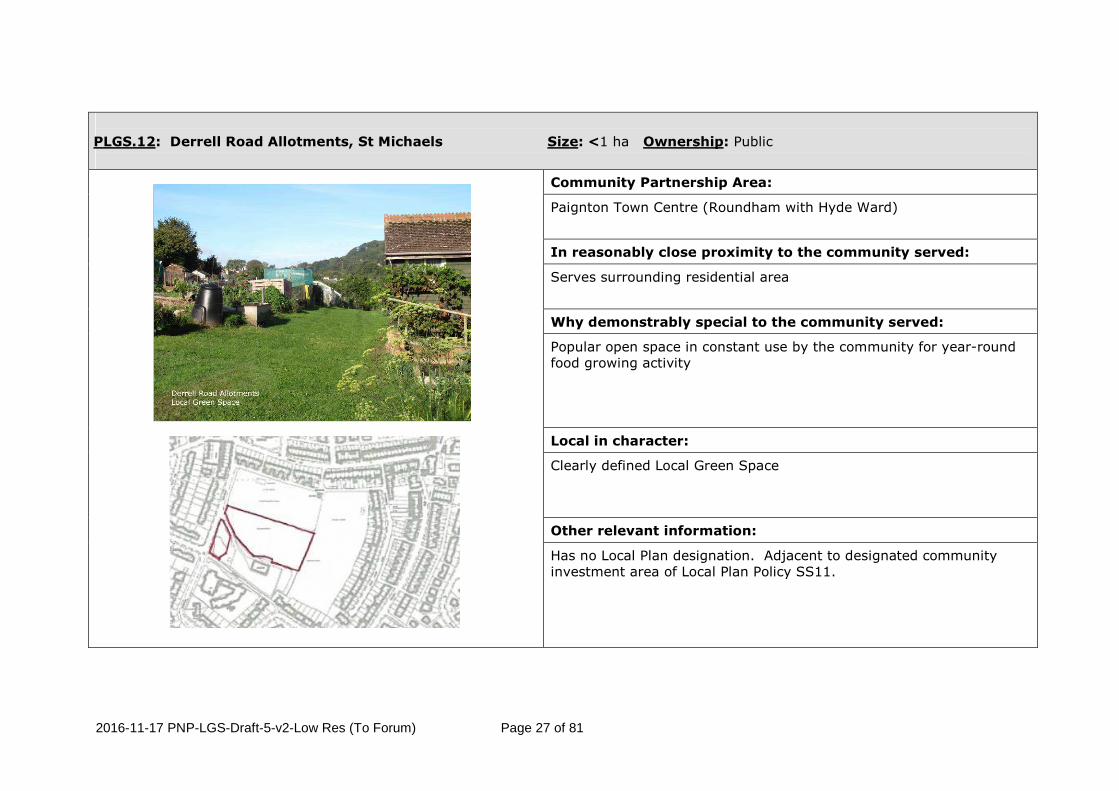
PLGS.12: Derrell Road Allotments, St Michaels Size: <1 ha Ownership: Public
Community Partnership Area:
Paignton Town Centre (Roundham with Hyde Ward)
In reasonably close proximity to the community served:
Serves surrounding residential area
Why demonstrably special to the community served:
Popular open space in constant use by the community for year-round food growing activity
Local in character:
Clearly defined Local Green Space
Other relevant information:
Has no Local Plan designation. Adjacent to designated community investment area of Local Plan Policy SS11.

2016-11-17 PNP-LGS-Draft-5-v2-Low Res (To Forum) Page 28 of 81
PLGS.13: Preston Green, Marine Drive Size: Abt 3 ha Ownership: Public
Community Partnership Area:
Preston
In reasonably close proximity to the community served:
Centrally located along seafront
Why demonstrably special to the community served:
Over 160 years community use for leisure and recreation.
Local in character:
Defined boundaries of long standing
Other relevant information:
Designated as an Urban Landscape Protection Area C5.33 by Policy C5 of the Local Plan that gives protection of the landscape value only. Public toilet included but not commercial boathouse restaurant to at south end.

2016-11-17 PNP-LGS-Draft-5-v2-Low Res (To Forum) Page 29 of 81
PLGS.14: Parkfield, Lower Polsham Rd, South of Parkfield BMX facility Size: <2 ha Ownership: Public
Community Partnership Area:
Preston
In reasonably close proximity to the community served:
Serves adjoining residential area, nearby tourists centres, and on-site adventure activity centre and social care facility
Why demonstrably special to the community served:
Public secluded woodland and open space perennially in use for recreation
Local in character:
Local green space with defined boundaries of long standing
Other relevant information:
Same boundary as Local Plan Urban Landscape Protection Area (C5.34) that gives partial protection of its landscape value only. Excludes Parkfield house. All within Conservation Area.

2016-11-17 PNP-LGS-Draft-5-v2-Low Res (To Forum) Page 30 of 81
PLGS.15: Coombe Valley Park, South West of Coombe Road, Preston Size: <1 ha Ownership: Public
Community Partnership Area:
Preston
In reasonably close proximity to the community served:
Serves surrounding residential area
Why demonstrably special to the community served:
Biodiverse wooded area(2) and open space in constant use for informal community recreation
Local in character:
Important wetland asset with multifunctional benefits(2)( 3) (including flood alleviation) and local green space enclosed by well defined housing infrastructure
Other relevant information:
No Local Plan designation given for the site.

2016-11-17 PNP-LGS-Draft-5-v2-Low Res (To Forum) Page 31 of 81
PLGS.16: Hollicombe Cliff Park, east of Torquay Road, Preston Size: <1 ha Ownership: Public
Community Partnership Area:
Preston
In reasonably close proximity to the community served:
Close to and easily accessed by local community and visitors via foot
Why demonstrably special to the community served:
Constantly used cliff-top green space for informal leisure by local residents and active holidaymakers
Local in character:
Seaside Local Green Space, and southern part of Livermead-Hollicombe County Wildlife Site(1), curtailed by surrounding cliffs beside the South West Coastal Path
Other relevant information:
No site designation in Local Plan.

2016-11-17 PNP-LGS-Draft-5-v2-Low Res (To Forum) Page 32 of 81
PLGS.17: Hollicombe Park (part of), Torquay Road Size: <1 ha Ownership: Public
Community Partnership Area:
Preston
In reasonably close proximity to the community served:
Serves adjacent residential area
Why demonstrably special to the community served:
Popular suburban play-park with open space in year-round use
Local in character:
Clearly defined local green space.
Other relevant information:
Straddles boundary with Torquay Neighbourhood Plan area Local Green Space. Identified in Local Plan as part of Coastal Change Management Area, Flood risk area, Countryside area, part of National Cycle Route. The south west corner boundary goes to Torquay Road

2016-11-17 PNP-LGS-Draft-5-v2-Low Res (To Forum) Page 33 of 81
PLGS.18: Wills Avenue Playground, Wills Avenue Size: <1 ha Ownership: Public
Community Partnership Area:
Preston
In reasonably close proximity to the community served:
Serves surrounding residential area
Why demonstrably special to the community served:
Popular small suburban play-park with open space in year-round use
Local in character:
Clearly defined local green space
Other relevant information:
No site designation in Local Plan.

2016-11-17 PNP-LGS-Draft-5-v2-Low Res (To Forum) Page 34 of 81
PLGS.19: Preston Gardens, Torquay Road Size: <1 ha Ownership: Public
Community Partnership Area:
Preston
In reasonably close proximity to the community served:
Serves adjoining residential area as well as retail and tourists centres nearby
Why demonstrably special to the community served:
Constantly used open area for amenity and relaxed leisure
Local in character:
Local green space with precise boundaries of long standing
Other relevant information:
No site designation in Local Plan.

2016-11-17 PNP-LGS-Draft-5-v2-Low Res (To Forum) Page 35 of 81
PLGS.20: Oldway Mansion Gardens, Oldway Road/Torquay Road Size: Abt 8 ha Ownership: Public
Community Partnership Area:
Preston
In reasonably close proximity to the community served:
Serves surrounding residential area, local visitors from across Torbay and contiguous tourist centres
Why demonstrably special to the community served:
Locally defining and historically important part of urban townscape well used by local residents for active or relaxed leisure and formal events for over 100 years
Local in character:
Local Green Space with familiar and specific boundaries of long standing
Other relevant information:
Part of Local Plan Policy SS10 area that protects the listed building and setting. LGS designation will add protection of the sites significant value as open space of importance to the local community. Gardens Listed (ref.no. 1001368).

2016-11-17 PNP-LGS-Draft-5-v2-Low Res (To Forum) Page 36 of 81
PLGS.21: Shorton Valley Woods, Shorton Valley Road Size: Abt 1 ha Ownership: Public
Community Partnership Area:
Preston
In reasonably close proximity to the community served:
Serves surrounding residential area
Why demonstrably special to the community served:
Mixed woodland and biodiverse area(1) in constant use by the community for informal recreation and leisure
Local in character:
A local green space and local wildlife site(1) forming part of the existing urban wildlife corridor(4) with multifunctional benefits
Other relevant information:
Part of Conservation Area. Defined on Local Plan as site of Local Wildlife Interest. Local Green Space designation adds protection of recreational value to community served.

2016-11-17 PNP-LGS-Draft-5-v2-Low Res (To Forum) Page 37 of 81
PLGS.22: Hollacombe Allotments, Hollacombe Lane Size: <1 ha Ownership: Public
Community Partnership Area:
Preston
In reasonably close proximity to the community served:
Serves surrounding residential area
Why demonstrably special to the community served:
Popular open space in constant use by the community for year-round food growing activity
Local in character:
Clearly defined Local Green Space
Other relevant information:
Within Local Plan defined Countryside area of Policy C1. LGS designation will add protection of sites importance to local community served.

2016-11-17 PNP-LGS-Draft-5-v2-Low Res (To Forum) Page 38 of 81
PLGS.23: Sandringham Gardens, Preston Size: <1 ha Ownership: Public
Community Partnership Area:
Preston
In reasonably close proximity to the community served:
Within residential community served
Why demonstrably special to the community served:
Highly regarded by community for panoramic views, wildlife (1), and tranquility. In constant use for leisure by local residents and passing visitors. Major contributor to area identity.
Local in character:
Field local to neighbourhood with well defined boundaries. Scenic Local Green Space of long standing and important constituent of Occombe Woods East local wildlife site.
Other relevant information:
Within Local Plan defined Countryside area of Policy C1 and local wildlife interest. LGS designation will add protection of sites importance to local community served.

2016-11-17 PNP-LGS-Draft-5-v2-Low Res (To Forum) Page 39 of 81
PLGS.24: Occombe Valley Woods, off Preston Down Road Size: Abt 37 ha Ownership: Public
Community Partnership Area:
Preston
In reasonably close proximity to the community served:
Serves surrounding residential area from multiple access points, and local visitors from across Torbay and tourist centres
Why demonstrably special to the community served:
Key green infrastructure asset(3), and biodiverse woodland area(1) in constant use by the local community and visitors for informal recreation and leisure.
Local in character:
Well defined natural area(3), local nature reserve(1)(3), county wildlife site(1), and important flood alleviation asset(2) with multifunctional benefits.
Other relevant information:
Identified as Country Park of Policy SS9 in Local Plan with wildlife value. Designation as Local Green Space will strengthens protection of recreation and leisure importance to local community.
2016-11-17 PNP-LGS-Draft-5-v2-Low Res (To Forum) Page 40 of 81
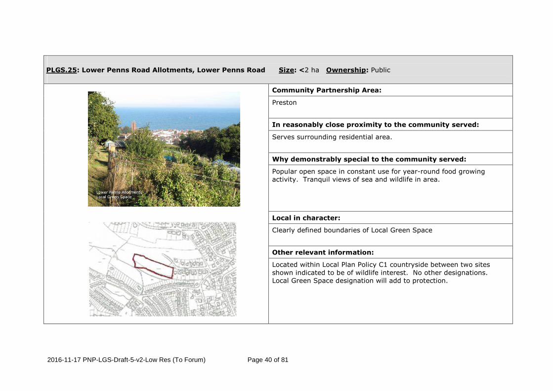
PLGS.25: Lower Penns Road Allotments, Lower Penns Road Size: <2 ha Ownership: Public
Community Partnership Area:
Preston
In reasonably close proximity to the community served:
Serves surrounding residential area.
Why demonstrably special to the community served:
Popular open space in constant use for year-round food growing activity. Tranquil views of sea and wildlife in area.
Local in character:
Clearly defined boundaries of Local Green Space
Other relevant information:
Located within Local Plan Policy C1 countryside between two sites shown indicated to be of wildlife interest. No other designations. Local Green Space designation will add to protection.

2016-11-17 PNP-LGS-Draft-5-v2-Low Res (To Forum) Page 41 of 81
PLGS.26: Scadson Woods, Duchy Drive. Size: Abt 9 ha (within PNP area) Ownership: Public
Community Partnership Area:
Preston
In reasonably close proximity to the community served:
Serves adjoining residential areas and local tourist centres
Why demonstrably special to the community served:
Significant green infrastructure asset and biodiverse woodland area with recreational, horse riding and bike trails in constant use by local community and vistors for informal recreation and leisure.
Local in character:
Well defined key natural area(3), local nature reserve(1)(3) and important flood alleviation asset(2) with multifunctional benefits.
Other relevant information:
Straddles boundary with Torquay Neighbourhood Plan area. Designated as Countryside in Local Plan Policy C1, Country Park Policy SS9, and with wildlife interest notations. Designation as Local Green Space will add to protection of the asset.
2016-11-17 PNP-LGS-Draft-5-v2-Low Res (To Forum) Page 42 of 81
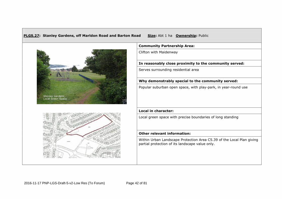
PLGS.27: Stanley Gardens, off Marldon Road and Barton Road Size: Abt 1 ha Ownership: Public
Community Partnership Area:
Clifton with Maidenway
In reasonably close proximity to the community served:
Serves surrounding residential area
Why demonstrably special to the community served:
Popular suburban open space, with play-park, in year-round use
Local in character:
Local green space with precise boundaries of long standing
Other relevant information:
Within Urban Landscape Protection Area C5.39 of the Local Plan giving partial protection of its landscape value only.

2016-11-17 PNP-LGS-Draft-5-v2-Low Res (To Forum) Page 43 of 81
PLGS.28: Ailescombe Road Allotments, Ailescombe Road Size: Abt 1 ha Ownership: Public
Community Partnership Area:
Clifton with Maidenway
In reasonably close proximity to the community served:
Serves surrounding residential area
Why demonstrably special to the community served:
Popular open space in constant use by the community for year-round food growing activity
Local in character:
Clearly defined Local Green Space
Other relevant information:
Within Urban Landscape Protection Area C5.39 of the Local Plan giving partial protection of its landscape value only.

2016-11-17 PNP-LGS-Draft-5-v2-Low Res (To Forum) Page 44 of 81
PLGS.29: Monastery, Winner Hill Size: Abt 1 ha Ownership: Public
Community Partnership Area:
Clifton with Maidenway
In reasonably close proximity to the community served:
Within residential community served
Why demonstrably special to the community served:
Highly regarded by community for its visual beauty, tranquil space, Monastic history and playground.
Local in character:
Local to neighbourhood with well defined boundaries
Other relevant information:
Part of Local Plan Urban Landscape Protection Area C5.40 that gives protection of the landscape value only. LGS designation will add protection of sites playspace and leisure importance to local community served.

2016-11-17 PNP-LGS-Draft-5-v2-Low Res (To Forum) Page 45 of 81
PLGS.30: Primley Woods & Meadow, Totnes Road Size: Abt 13 ha Ownership: Private
Community Partnership Area:
Clifton with Maidenway and Blatchcombe
In reasonably close proximity to the community served:
Close to and easily accessed by local community via foot
Why demonstrably special to the community served:
Mixed woodland, biodiverse area(1) and open space in constant use by the community for informal recreation and leisure
Local in character:
An enclosed Key Green Infrastructure asset(4), local wildlife site1 and natural play area(4) with multifunctional benefits
Other relevant information:
Part of designated Urban Landscape Protection Area C5.41 giving partial protection of its landscape value only. Adjacent to Local Plan Policy SS11 Community Investment Area. Identified also in Local Plan to be of Wildlife Interest (OSW1). Proposed LGS boundary excludes Primley House complex.

2016-11-17 PNP-LGS-Draft-5-v2-Low Res (To Forum) Page 46 of 81
PLGS.31: Paignton Cemetery, Colley End Road Size: Abt 4 ha Ownership: Public
Community Partnership Area:
Clifton with Maidenway
In reasonably close proximity to the community served:
Serves surrounding residential areas.
Why demonstrably special to the community served:
Constantly used quiet open area for memorial, contemplation and formal commemorative events.
Local in character:
Local space with clearly defined boundaries.
Other relevant information:
Within Urban Landscape Protection Area C5.39 of the Local Plan giving partial protection of its landscape value only.

2016-11-17 PNP-LGS-Draft-5-v2-Low Res (To Forum) Page 47 of 81
PLGS.32: Clennon Valley Size: Abt 67 ha Ownership: Public
Community Partnership Area:
Goodrington, Roseland and Hookhills
In reasonably close proximity to the community served:
Serves surrounding residential areas and tourist centres nearby
Why demonstrably special to the community served:
Biodiverse(1) naturally landscaped valley, Key Natural Area(5) and wetland(4) used by local community and tourists for informal and formal recreation
Local in character:
Local Green Space, which includes Clennon Woods and Clennon Ponds County Wildlife Sites(1) and Grange Farm Local wildlife site(1), needing to be large in area to fulfill its various roles.
Other relevant information:
No consents for development. Designated as an Urban Landscape Protection Area (C5.44) by Policy C5 of the Torbay Local Plan giving partial protection of its landscape value. LGS boundary as ULPA of Local Plan plus playing fields included in Local Plan Policy SC2.4 that add significantly to the open space value.

2016-11-17 PNP-LGS-Draft-5-v2-Low Res (To Forum) Page 48 of 81
PLGS.33: Clennon Valley Allotments, Dartmouth Road Size: Abt 1 ha Ownership: Public
Community Partnership Area:
Goodrington, Roseland and Hookhills
In reasonably close proximity to the community served:
Serves surrounding residential area
Why demonstrably special to the community served:
Popular open space in constant use by the community for year-round food growing activity
Local in character:
Clearly defined Local Green Space
Other relevant information:
No Local Plan site designations
2016-11-17 PNP-LGS-Draft-5-v2-Low Res (To Forum) Page 49 of 81
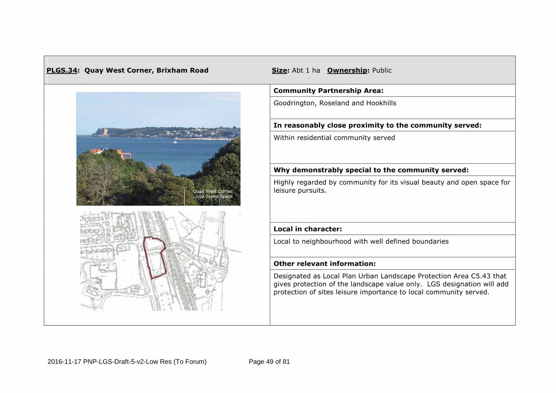
PLGS.34: Quay West Corner, Brixham Road Size: Abt 1 ha Ownership: Public
Community Partnership Area:
Goodrington, Roseland and Hookhills
In reasonably close proximity to the community served:
Within residential community served
Why demonstrably special to the community served:
Highly regarded by community for its visual beauty and open space for leisure pursuits.
Local in character:
Local to neighbourhood with well defined boundaries
Other relevant information:
Designated as Local Plan Urban Landscape Protection Area C5.43 that gives protection of the landscape value only. LGS designation will add protection of sites leisure importance to local community served.

2016-11-17 PNP-LGS-Draft-5-v2-Low Res (To Forum) Page 50 of 81
PLGS.35: Young’s Park rec. and wetland area SW of Young’s Park Rd, Goodrington Size: Abt 3 ha Ownership: Public
Community Partnership Area:
Goodrington, Roseland and Hookhills
In reasonably close proximity to the community served:
Serves adjoining residential area and nearby tourists centres
Why demonstrably special to the community served:
Mixed woodland, biodiverse area(2) and open space in constant use by the whole community and tourists for informal recreation and leisure
Local in character:
A local green space and important wetland asset for defence against coastal erosion(2)( 4) with clear long-established boundaries. Includes eastern section of Clennon Ponds County Wildlife Site(1)
Other relevant information:
Part of Local Plan Urban Landscape Protection Area (C5.42) that gives protection of its landscape value only. Excludes adjacent tourist building complex boating lake and car park.

2016-11-17 PNP-LGS-Draft-5-v2-Low Res (To Forum) Page 51 of 81
PLGS.36: Oyster Bend Field, east of Oyster Bend Size: Abt 2 ha Ownership: Public
Community Partnership Area:
Goodrington, Roseland and Hookhills
In reasonably close proximity to the community served:
Serves adjoining residential area and tourists centres nearby
Why demonstrably special to the community served:
Constantly used open area for wildlife conservation, amenity and relaxed leisure
Local in character:
Cliff-top Local Green Space with precise boundaries of long standing enclosed within the Saltern Cove Site of Special Scientific Interest1 and Saltern Cove and Sugar Loaf Local Nature Reserve(1)
Other relevant information:
Adjacent land of Steam Railway excluded.

2016-11-17 PNP-LGS-Draft-5-v2-Low Res (To Forum) Page 52 of 81
PLGS.37: Goodrington Community Orchard, Goodrington Road Size: <1 ha Ownership: Public
Community Partnership Area:
Goodrington, Roseland and Hookhills
In reasonably close proximity to the community served:
Serves surrounding residential area
Why demonstrably special to the community served:
Popular open space in constant use by the community for leisure and voluntary food growing activity
Local in character:
Local Green Space with defined boundaries of long standing
Other relevant information:
No Local Plan site designations. Orchard planted by community.

2016-11-17 PNP-LGS-Draft-5-v2-Low Res (To Forum) Page 53 of 81
PLGS.38: Goodrington Village Green, Grange Road Size: <1 ha Ownership: Public
Community Partnership Area:
Goodrington, Roseland and Hookhills
In reasonably close proximity to the community served:
Serves surrounding residential area
Why demonstrably special to the community served:
Continually used open area for wildlife conservation, amenity and relaxed leisure
Local in character:
Clearly defined Local Green Space
Other relevant information:
No Local Plan site designations

2016-11-17 PNP-LGS-Draft-5-v2-Low Res (To Forum) Page 54 of 81
PLGS.39: Claylands Cross Park – Brixham Road, North of Harbourne Avenue Size: <1 ha Ownership: Public
Community Partnership Area:
Goodrington, Roseland and Hookhills
In reasonably close proximity to the community served:
Conveniently situated alongside local dwellings
Why demonstrably special to the community served:
Play-park and sports area providing daily recreational facilities for nearby residents
Local in character:
Key out-of-town Local Green Space enclosed by established housing, transport and green infrastructure
Other relevant information:
No Local Plan designation of the site.

2016-11-17 PNP-LGS-Draft-5-v2-Low Res (To Forum) Page 55 of 81
PLGS.40: Gibson Road Playground, Gibson Road Size: <1 ha Ownership: Public
Community Partnership Area:
Goodrington, Roseland and Hookhills
In reasonably close proximity to the community served:
Serves surrounding residential area
Why demonstrably special to the community served:
Popular suburban play-park with open space in year-round use
Local in character:
Clearly defined Local Green Space
Other relevant information:
No Local Plan site designations.

2016-11-17 PNP-LGS-Draft-5-v2-Low Res (To Forum) Page 56 of 81
PLGS.41: White Rock Recreation Ground, Brixham Road Size: Abt 2 ha Ownership: Public
Community Partnership Area:
Goodrington, Roseland and Hookhills
In reasonably close proximity to the community served:
Serves adjoining residential area and conveniently situated alongside primary transport infrastructure for visitors
Why demonstrably special to the community served:
Open sports and leisure area providing daily recreational facilities for the community and visiting sport participants from outside the area
Local in character:
Important out-of-town Local Green Space enclosed by established housing, transport and White Rock Primary School
Other relevant information:
No Local Plan site designations

2016-11-17 PNP-LGS-Draft-5-v2-Low Res (To Forum) Page 57 of 81
PLGS.42: York Road Allotments, York Road Size: Abt 2 ha Ownership: Public
Community Partnership Area:
Goodrington, Roseland and Hookhills
In reasonably close proximity to the community served:
Serves surrounding residential area
Why demonstrably special to the community served:
Popular open space in constant use by the community for year-round food growing activity
Local in character:
Clearly defined Local Green Space
Other relevant information:
Site has no allocation in Local Plan.

2016-11-17 PNP-LGS-Draft-5-v2-Low Res (To Forum) Page 58 of 81
PLGS.43: Hookhills Playground & Park, Freshwater Drive Size: Abt 1 ha Ownership: Public
Community Partnership Area:
Goodrington, Roseland and Hookhills
In reasonably close proximity to the community served:
Serves surrounding residential area.
Why demonstrably special to the community served:
Popular suburban play-park with open spaces and connecting green walks in year-round use by pedestrians and leisure seekers.
Local in character:
Clearly defined local boundaries.
Other relevant information:
No designation on Local Plan policy map.

2016-11-17 PNP-LGS-Draft-5-v2-Low Res (To Forum) Page 59 of 81
PLGS.44: Lancaster Drive Playpark, Lancaster Drive Size: <1 ha Ownership: Public
Community Partnership Area:
Goodrington, Roseland and Hookhills
In reasonably close proximity to the community served:
Serves surrounding residential area.
Why demonstrably special to the community served:
Popular suburban play-park in year-round use for recreation and relaxation.
Local in character:
Clearly defined Local Green Space.
Other relevant information:
Within area identified in Local Plan as of Wildlife Interest and adjacent to Urban Landscape Protection Area C.44. LGS designation will add protection of the green space recreation value.

2016-11-17 PNP-LGS-Draft-5-v2-Low Res (To Forum) Page 60 of 81
PLGS.45: Cherry Brook Square, Cherry Brook Drive Size: <1 ha Ownership: Public
Community Partnership Area:
Goodrington, Roseland and Hookhills
In reasonably close proximity to the community served:
Serves surrounding residential area.
Why demonstrably special to the community served:
Informal suburban green space with popular play-park used constantly by residents for relaxed leisure and amenity.
Local in character:
Clearly defined Local Green Space.
Other relevant information:
Within area identified in Local Plan as Local / Neighbourhood shopping centre. LGS designation will add protection of the green space recreation value.

2016-11-17 PNP-LGS-Draft-5-v2-Low Res (To Forum) Page 61 of 81
PLGS.46: Goodrington Road Amenity Area Size: <2 ha Ownership: Public
Community Partnership Area:
Goodrington, Roseland and Hookhills
In reasonably close proximity to the community served:
Serves surrounding residential area and visitors from across Torbay.
Why demonstrably special to the community served:
Green lung and open area used year-round by residents and visitors for informal leisure and amenity.
Local in character:
Clearly defined Local Green Space.
Other relevant information:
Undesignated area within Local Plan. LGS designation will add protection of the green space recreation value.

2016-11-17 PNP-LGS-Draft-5-v2-Low Res (To Forum) Page 62 of 81
PLGS.47: Primley Park, South of Westleat Avenue Size: Abt 2 ha Ownership: Public
Community Partnership Area:
Blatchcombe
In reasonably close proximity to the community served:
Adjacent to community served
Why demonstrably special to the community served:
Popular suburban open space and play-park in year-round use
Local in character:
Local Green Space bordering Primley Woods Local Wildlife Site(1) and neighbourhood homes
Other relevant information:
Within boundary of Local Plan Policy SS11 Community Investment Area and designated Urban Landscape Protection Area C5.41 giving partial protection of its landscape value only. Adjacent to site identified in Local Plan to be of Wildlife Interest (OSW1).

2016-11-17 PNP-LGS-Draft-5-v2-Low Res (To Forum) Page 63 of 81
PLGS.48: Redwell Road Size: <1 ha Ownership: Public
Community Partnership Area:
Blatchcombe
In reasonably close proximity to the community served:
Serves surrounding residential area
Why demonstrably special to the community served:
Convenient and continually used children’s recreational facility and open area
Local in character:
Small clearly defined local green space
Other relevant information:
No site designation in Local Plan.

2016-11-17 PNP-LGS-Draft-5-v2-Low Res (To Forum) Page 64 of 81
PLGS.49: Smallcombe Scout Field, Redwell Lane Size: <1 ha Ownership: Public
Community Partnership Area:
Blatchcombe
In reasonably close proximity to the community served:
Serves surrounding residential area
Why demonstrably special to the community served:
Continually used open area for amenity, relaxed leisure and formerly used for Scouting activities.
Local in character:
Clearly defined Local Green Space
Other relevant information:
Without designation in Local Plan. Adjacent to designated Community Investment Area. LGS designation will add protection of the green space. Planning application for 5 dwellings submitted over a year ago (August 2015) not yet determined (P/2015/0678).

2016-11-17 PNP-LGS-Draft-5-v2-Low Res (To Forum) Page 65 of 81
PLGS.50: Smallcombe Road Playground and Park, Jasmine Grove Size: <1 ha Ownership: Public
Community Partnership Area:
Blatchcombe
In reasonably close proximity to the community served:
Serves surrounding residential area
Why demonstrably special to the community served:
Popular suburban play-park with small park and connecting green walk in year-round use for recreation, nature conservation and relaxation.
Local in character:
Clearly defined Local Green Space
Other relevant information:
Without designation in Local Plan. LGS designation will add protection of the green space.

2016-11-17 PNP-LGS-Draft-5-v2-Low Res (To Forum) Page 66 of 81
PLGS.51: Wild Fox Adventure Playground, Smallcombe Road Size: <1 ha Ownership: Public
Community Partnership Area:
Blatchcombe.
In reasonably close proximity to the community served:
Serves adjoining residential area.
Why demonstrably special to the community served:
Wildlife adventure playground and green area used by children of the local community for leisure and informal recreation. Recently extended in size as a community playground (P/2014/0450).
Local in character:
Clearly defined local boundaries.
Other relevant information:
Without designation in Local Plan. Adjacent to committed development site CDSP7 recently constructed. LGS designation will add protection of the recreation value to the local community.
Insert photo

2016-11-17 PNP-LGS-Draft-5-v2-Low Res (To Forum) Page 67 of 81
PLGS.52: Foxhole Community Field, off Belfield Road Size: Abt.1 ha Ownership: Public
Community Partnership Area:
Blatchcombe.
In reasonably close proximity to the community served:
Serves adjoining residential area.
Why demonstrably special to the community served:
Part of community centre serving surrounding area used by community for local events and activities.
Local in character:
Clearly defined local boundaries.
Other relevant information:
Without designation in Local Plan. Adjacent to committed development site CDSP7 recently constructed. LGS designation will add protection of the green space value to the community.
Insert photo

2016-11-17 PNP-LGS-Draft-5-v2-Low Res (To Forum) Page 68 of 81
PLGS.53: Great Parks Play Area, Trelissick Road Size: <1 ha Ownership: Public
Community Partnership Area:
Blatchcombe
In reasonably close proximity to the community served:
Serves surrounding residential area
Why demonstrably special to the community served:
Local recreation area and community open space with sports facilities in daily use
Local in character:
Clearly defined Local Green Space
Other relevant information:
Within Country Park designation of Policy SS9 in Local Plan and protected County Wildlife site. LGS designation will add protection of the green space.

2016-11-17 PNP-LGS-Draft-5-v2-Low Res (To Forum) Page 69 of 81
PLGS.54: Great Parks, off Great Parks Lane Size: Abt 27 ha Ownership: Public and Private
Community Partnership Area:
Blatchcombe
In reasonably close proximity to the community served:
Serves surrounding residential areas and visitors from across Torbay.
Why demonstrably special to the community served:
Biodiverse(1)(4) emerging parkland area within Ramshill County Wildlife site used year-round by bordering local community, with lack of access to greenspace (4), and visitors for assorted pursuits including amenity, relaxed leisure, wildlife watching and countryside activities.
Local in character:
Important out-of-town Local Green Space, proposed Food and Geopark Access Hub(4)(5), Key Natural Area(5) , Orchard Enhancement Zone(4)(7), and potential Country Park(4)(6) enclosed by established housing, transport infrastructure and wider rural area
Other relevant information:
Within proposed Country Park designation of Policy SS9 in Local Plan and protected County Wildlife site. LGS designation will add protection of the green space.

2016-11-17 PNP-LGS-Draft-5-v2-Low Res (To Forum) Page 70 of 81
PLGS.55: Snowdonia Close, Collaton St Mary Size: <1 ha Ownership: Public
Community Partnership Area:
Blatchcombe.
In reasonably close proximity to the community served:
Serves adjoining residential area.
Why demonstrably special to the community served:
Open area and green used by local residents constantly for leisure and informal recreation.
Local in character:
Clearly defined local boundaries.
Other relevant information:
Without designation in Local Plan. Adjacent to Yalberton Industrial estate. LGS designation will add protection of the green space value.

2016-11-17 PNP-LGS-Draft-5-v2-Low Res (To Forum) Page 71 of 81
PLGS.56: Pennine Drive Amenity Area, Collaton St Mary Size: <1 ha Ownership: Public
Community Partnership Area:
Blatchcombe.
In reasonably close proximity to the community served:
Serves adjoining residential area.
Why demonstrably special to the community served:
Open area and green used by local residents constantly for leisure and informal recreation.
Local in character:
Clearly defined local boundaries.
Other relevant information:
Without designation in Local Plan. LGS designation will add protection of the green space value.

2016-11-17 PNP-LGS-Draft-5-v2-Low Res (To Forum) Page 72 of 81
PLGS.57: Westerland Valley Size: Abt 27 ha Ownership: Private
Community Partnership Area:
Blatchcombe
In reasonably close proximity to the community served:
Serves surrounding residential areas and bay-wide tourist centres
Why demonstrably special to the community served:
Its beauty from ring road views. Key natural landscaped valley(4) used year-round by local community and visitors for miscellaneous pursuits including food production, amenity, relaxed leisure and countryside activities
Local in character:
Tranquil attractive biodiverse(1)(4) local green space with boundaries clearly defined by the Ramshill County Wildlife site and Unitary Authority border(1)
Other relevant information:
Located within Local Plan Policy C1 countryside and County Wildlife Site. No other designations. Excludes existing Garden Centre.

2016-11-17 PNP-LGS-Draft-5-v2-Low Res (To Forum) Page 73 of 81
PLGS.58: Yalberton Valley Size: Abt 36 ha Ownership: Private
Community Partnership Area:
Blatchcombe
In reasonably close proximity to the community served:
Within walking, cycling, riding distance of Yalberton, Collaton St Mary, Stoke Gabriel, South Devon College, Whiterock and five holiday centres in close proximity. Also used for running by staff and students of South Devon College.
Why demonstrably special to the community served:
Beautiful tranquil valley following Yalberton stream, much visited for abundant range of flora and fauna(1), ancient Devon Green Lane and historic cider producing orchards. Valley one of best examples of an active karstic drainage system in Torbay. Foraging area for bat species and roosting sites in Valley's caves
Local in character:
Follows line of Yalberton Stream(1), Local Wildlife Site (LWS) and its natural green space features including part of LWS Waddeton Woods(1). Whole of Lower Yalberton is an Orchard Enhancement Zone(4)&(7) and a LWS (also a potential County Wildlife Site(1)) containing many natural springs
Other relevant information:
Located within Local Plan Policy C1 countryside with noted wildlife interest. No other designations. Existing built areas excluded.

2016-11-17 PNP-LGS-Draft-5-v2-Low Res (To Forum) Page 74 of 81
PLGS.59: Collaton St Mary Water Meadow, Stoke Road Size: Abt 4 ha Ownership: Private
Community Partnership Area:
Blatchcombe
In reasonably close proximity to the community served:
Within Collaton St Mary Village community
Why demonstrably special to the community served:
Highly regarded by local community for visual contribution made to open space character of village and contribution to protected Greater Horseshoe bats and flood protection to inhabitants.
Local in character:
Field local to Village served with well defined boundaries
Other relevant information:
Within Local Plan Future Growth Area Policy SS2.2. Shown retained as green open space in adopted Collaton St Mary Masterplan / SPD. LGS designation will add protection of the space in accord with the adopted SPD.

2016-11-17 PNP-LGS-Draft-5-v2-Low Res (To Forum) Page 75 of 81
PLGS.60: Little Blagdon / Sunday Car Boot Field, Totnes Road Size: Abt 3 ha Ownership: Private
Community Partnership Area:
Blatchcombe
In reasonably close proximity to the community served:
On boundary of Collaton St Mary Village community. Historically used by local community and visitors for occasional market
Why demonstrably special to the community served:
Highly regarded by local community for visual contribution made to views of rolling countryside beyond and contribution to protected Greater Horseshoe bats.
Local in character:
Field local to Village served with well defined boundaries
Other relevant information:
Within Local Plan Future Growth Area Policy SS2.2. Shown retained as green open space in adopted Collaton St Mary Masterplan / SPD. LGS designation will add protection of the space in accord with the adopted SPD.

2016-11-17 PNP-LGS-Draft-5-v2-Low Res (To Forum) Page 76 of 81
PLGS.61: Brake Copse, Totnes Road Size: <3 ha Ownership: Private
Community Partnership Area:
Blatchcombe
In reasonably close proximity to the community served:
Serves adjoining residential area.
Why demonstrably special to the community served:
Constantly used broadleaf woodland and biodiverse area(1) for nature interaction, amenity and relaxed leisure.
Local in character:
A well defined local enclosed space and wildlife site(1) forming part of existing rural wildlife corridor(4) with multifunctional benefits.
Other relevant information:
Within designated countryside area C1 of Local Plan, with noted wildlife interest. Designation as Local Green Space will give recognition to the sites wider community vale.
2016-11-17 PNP-LGS-Draft-5-v2-Low Res (To Forum) Page 77 of 81
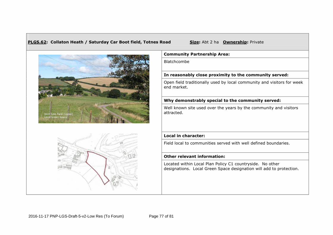
PLGS.62: Collaton Heath / Saturday Car Boot field, Totnes Road Size: Abt 2 ha Ownership: Private
Community Partnership Area:
Blatchcombe
In reasonably close proximity to the community served:
Open field traditionally used by local community and visitors for week end market.
Why demonstrably special to the community served:
Well known site used over the years by the community and visitors attracted.
Local in character:
Field local to communities served with well defined boundaries.
Other relevant information:
Located within Local Plan Policy C1 countryside. No other designations. Local Green Space designation will add to protection.

2016-11-17 PNP-LGS-Draft-5-v2-Low Res (To Forum) Page 78 of 81
Appendix XX
Planning Practice Guidance: Local Green Space Paragraph: 005 Reference ID: 37-005-20140306
What is Local Green Space designation?
Local Green Space designation is a way to provide special protection against
development for green areas of particular importance to local communities.
[Revision date: 06 03 2014] Paragraph: 006 Reference ID: 37-006-20140306
How is land designated as Local Green Space?
Local Green Space designation is for use in Local Plans or Neighbourhood Plans.
These plans can identify on a map (‘designate’) green areas for special protection.
Anyone who wants an area to be designated as Local Green Space should contact the
local planning authority about the contents of its local plan or get involved in
neighbourhood planning.
[Revision date: 06 03 2014] Paragraph: 007 Reference ID: 37-007-20140306
How does Local Green Space designation relate to development?
Designating any Local Green Space will need to be consistent with local planning for
sustainable development in the area. In particular, plans must identify sufficient
land in suitable locations to meet identified development needs and the Local Green
Space designation should not be used in a way that undermines this aim of plan
making.
[Revision date: 06 03 2014] Paragraph: 008 Reference ID: 37-008-20140306
What if land has planning permission for development?
Local Green Space designation will rarely be appropriate where the land has planning
permission for development. Exceptions could be where the development would be
compatible with the reasons for designation or where planning permission is no
longer capable of being implemented.
[Revision date: 06 03 2014] Paragraph: 009 Reference ID: 37-009-20140306
Can all communities benefit from Local Green Space?
Local Green Spaces may be designated where those spaces are demonstrably special
to the local community, whether in a village or in a neighbourhood in a town or city.
[Revision date: 06 03 2014] Paragraph: 010 Reference ID: 37-010-20140306
What if land is already protected by Green Belt or as Metropolitan Open Land
(in London)?
If land is already protected by Green Belt policy, or in London, policy on Metropolitan
Open Land, then consideration should be given to whether any additional local
benefit would be gained by designation as Local Green Space.

2016-11-17 PNP-LGS-Draft-5-v2-Low Res (To Forum) Page 79 of 81
One potential benefit in areas where protection from development is the norm (e.g.
villages included in the green belt) but where there could be exceptions is that the
Local Green Space designation could help to identify areas that are of particular
importance to the local community.
[Revision date: 06 03 2014]
Paragraph: 011 Reference ID: 37-011-20140306
What if land is already protected by designations such as National Park,
Area of Outstanding Natural Beauty, Site of Special Scientific Interest,
Scheduled Monument or conservation area?
Different types of designations are intended to achieve different purposes. If land is
already protected by designation, then consideration should be given to whether any
additional local benefit would be gained by designation as Local Green Space.
[Revision date: 06 03 2014] Paragraph: 012 Reference ID: 37-012-20140306
What about new communities?
New residential areas may include green areas that were planned as part of the
development. Such green areas could be designated as Local Green Space if they are
demonstrably special and hold particular local significance.
[Revision date: 06 03 2014] Paragraph: 013 Reference ID: 37-013-20140306
What types of green area can be identified as Local Green Space?
The green area will need to meet the criteria set out in paragraph 77 of the National
Planning Policy Framework. Whether to designate land is a matter for local discretion.
For example, green areas could include land where sports pavilions, boating lakes or
structures such as war memorials are located, allotments, or urban spaces that
provide a tranquil oasis.
[Revision date: 06 03 2014]
Paragraph: 014 Reference ID: 37-014-20140306
How close does a Local Green Space need to be to the community it serves?
The proximity of a Local Green Space to the community it serves will depend on local
circumstances, including why the green area is seen as special, but it must be
reasonably close. For example, if public access is a key factor, then the site would
normally be within easy walking distance of the community served.
[Revision date: 06 03 2014] Paragraph: 015 Reference ID: 37-015-20140306
How big can a Local Green Space be?
There are no hard and fast rules about how big a Local Green Space can be because
places are different and a degree of judgment will inevitably be needed. However,
paragraph 77 of the National Planning Policy Framework is clear that Local Green
Space designation should only be used where the green area concerned is not an
extensive tract of land. Consequently blanket designation of open countryside
adjacent to settlements will not be appropriate. In particular, designation should not
be proposed as a ‘back door’ way to try to achieve what would amount to a new area
of Green Belt by another name.
[Revision date: 06 03 2014] Paragraph: 016 Reference ID: 37-016-20140306

2016-11-17 PNP-LGS-Draft-5-v2-Low Res (To Forum) Page 80 of 81
Is there a minimum area?
Provided land can meet the criteria at paragraph 77 of the National Planning Policy
Framework there is no lower size limit for a Local Green Space.
[Revision date: 06 03 2014] Paragraph: 017 Reference ID: 37-017-20140306
What about public access?
Some areas that may be considered for designation as Local Green Space may
already have largely unrestricted public access, though even in places like parks
there may be some restrictions. However, other land could be considered for
designation even if there is no public access (e.g. green areas which are valued
because of their wildlife, historic significance and/or beauty). Designation does not
in itself confer any rights of public access over what exists at present. Any additional
access would be a matter for separate negotiation with land owners, whose legal
rights must be respected.
[Revision date: 06 03 2014] Paragraph: 018 Reference ID: 37-018-20140306
What about public rights of way?
Areas that may be considered for designation as Local Green Space may be crossed
by public rights of way. There is no need to designate linear corridors as Local Green
Space simply to protect rights of way, which are already protected under other
legislation.
[Revision date: 06 03 2014] Paragraph: 019 Reference ID: 37-019-20140306
Does land need to be in public ownership?
A Local Green Space does not need to be in public ownership. However, the local
planning authority (in the case of local plan making) or the qualifying body (in the
case of neighbourhood plan making) should contact landowners at an early stage
about proposals to designate any part of their land as Local Green Space.
Landowners will have opportunities to make representations in respect of proposals
in a draft plan.
[Revision date: 06 03 2014] Paragraph: 020 Reference ID: 37-020-20140306
Would designation place any restrictions or obligations on landowners?
Designating a green area as Local Green Space would give it protection consistent
with that in respect of Green Belt, but otherwise there are no new restrictions or
obligations on landowners.
[Revision date: 06 03 2014] Paragraph: 021 Reference ID: 37-021-20140306
Who will manage Local Green Space?
Management of land designated as Local Green Space will remain the responsibility
of its owner. If the features that make a green area special and locally significant are
to be conserved, how it will be managed in the future is likely to be an important
consideration. Local communities can consider how, with the landowner’s agreement,
they might be able to get involved, perhaps in partnership with interested
organisations that can provide advice or resources.
[Revision date: 06 03 2014]

2016-11-17 PNP-LGS-Draft-5-v2-Low Res (To Forum) Page 81 of 81
Paragraph: 022 Reference ID: 37-022-20140306
Can a Local Green Space be registered as an Asset of Community Value?
Land designated as Local Green Space may potentially also be nominated for listing
by the local authority as an Asset of Community Value. Listing gives community
interest groups an opportunity to bid if the owner wants to dispose of the land.
[Revision date: 06 03 2014]


![PnP THERMOMETER H4 - OPMID オプミッド ...opmid.co.jp/wp-content/uploads/2015/02/M1006A_H4_.pdf2 [1]PnP サーモメーター PnP Thermometer PnP サーモメーター PnP Thermometer](https://img.pdfslide.net/doc/110x75/5ac1b8ee7f8b9aca388d5bdc/pnp-thermometer-h4-opmid-opmidcojpwp-contentuploads201502m1006ah4pdf2.jpg)


![;}lgs P]g, @)^#](https://img.pdfslide.net/doc/110x75/61bd368361276e740b10788d/lgs-pg-.jpg)