Embed Size (px)
Citation preview
~200 Glorious Miles2018 TIR Written Directions
(Prologue - Leg 3)
Prologue (1.15 miles)Follow the flags from the Memorial Muse-um, around the historic Gonzales court-house, and back!.04m - Left on St. Lawrence
.56m - Left on St. Joseph
.62m - Left on St. Louis
Leg 1 (4.26 miles)Straight on St. Louis St.
1.45m - Right on Hwy 90A (stay on rightshoulder of Hwy)
1.79m - Right on County Road 342 (Kelley Loop)
4.05m - Left on CoRd 343 to the Exchange
Leg 2 (5.15 miles)Immediate Right on Hwy 90A. Run on left hand shoulder (facing traffic).
4.82m - Left on CoRd 361 near the end ofthe leg (just after crossing Peach Creek), and proceed to Sam Houston’s Oak!
Leg 3 (4.86 miles)1.48m - Left on CoRd 357 (where 361 ends)
3.1 - Right on CoRd 355 at the 5K markof the leg. CoRd 355 does not cross 357 - It is only on the right, and this turn is just after passing an oil field on the left. Continue on 355to Exch 3, making a 90degree rightward turnat 3.8miles and another 90degree leftward turnat 4.05m (no choices - these are just curves of 355). From about a half mile away runners will be able to see the finish at the top of the hill!
~200 Glorious Miles2018 TIR Written Directions
(Leg 5 - Leg 7)
Leg 5 (3.92 miles)Straight on 355 towards Shiner. Just under1/2 mile into this leg, 355’s name is changedto 349, but it is almost unnoticeable.)2.2m - Right on 348 (where 355/349 T’s into it.2.25m - Immediate left on 90A.3.82m - Left on 7th St. (just before the train tracks) * Be cautious with blind turns on Leg 5
Leg 6 (4.08 miles)
0.00m - Immediate Left on N Avenue D.0.33m - Right on E 12th (Ave D T’s into 12th)0.47m - Left on N Avenue B. (which becomesCoRd 351.3.47m - Left to stay on 351 at 351/353, where 351 T’s into this (at a stop sign). Then,351 curves 90deg to the right at 3.63m, just under a half mile from the finish.
Leg 7 (3.71 miles)0.00m - Continue straight on 351 for 1.6muntil 351 curves 90degrees right.1.6m - Right (technically, it just staying on 351, and this does look like the natural turn of theroad, but there are also a couple of optionshere, so we’re treating it as a right turn.) at1.85m, 351 curves 90degrees again (but left)2.49m - Left on 294 (where 351 T’s into 294). After the left 294 immediately curves right.3.23m - Right on 290 (where 294 T’s into 290), and follow to the exchange.
-
Leg 4 (4.08 miles)
Continue on 355 for the entire leg. Runnerswill pass an oil field driveway (to the left) and363 (on the right) at 0.6m. Pass 354 (to theleft) at 1.25m. 355 has curves. Passintersection of 355 and 364 at 3.07m (thisintersection is a 4-way stop with pint-sized stopsigns and can serve as the mile-to-go mark).
~200 Glorious Miles2018 TIR Written Directions
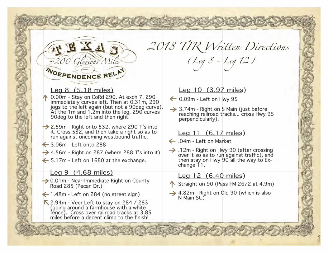
(Leg 8 - Leg 12)
Leg 9 (4.68 miles)0.01m - Near-Immediate Right on County Road 285 (Pecan Dr.)1.48m - Left on 284 (no street sign)2.94m - Veer Left to stay on 284 / 283 (going around a farmhouse with a white fence). Cross over railroad tracks at 3.85 miles before a decent climb to the finish!
Leg 8 (5.18 miles)0.00m - Stay on CoRd 290. At exch 7, 290immediately curves left. Then at 0.31m, 290 jogs to the left again (but not a 90deg curve). At the 1m and 1.2m into the leg, 290 curves 90deg to the left and then right.
2.59m - Right onto 532, where 290 T’s intoit. Cross 532, and then take a right so as to run against oncoming westbound traffic.3.06m - Left onto 2884.56m - Right on 287 (where 288 T’s into it)5.17m - Left on 1680 at the exchange.
Leg 10 (3.97 miles)0.09m - Left on Hwy 95 3.74m - Right on S Main (just before reaching railroad tracks... cross Hwy 95 perpendicularly).
Leg 11 (6.17 miles).04m - Left on Market.12m - Right on Hwy 90 (after crossing over it so as to run against traffic), and then stay on Hwy 90 all the way to Ex-change 11.
Leg 12 (6.40 miles)Straight on 90 (Pass FM 2672 at 4.9m)4.82m - Right on Old 90 (which is also N Main St.)
~200 Glorious Miles2018 TIR Written Directions
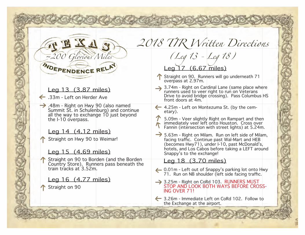
(Leg 13 - Leg 18)
Leg 13 (3.87 miles).33m - Left on Herder Ave .48m - Right on Hwy 90 (also named Summit St. in Schulenburg) and continue all the way to exchange 10 just beyond the I-10 overpass.
Leg 14 (4.12 miles)Straight on Hwy 90 to Weimar!
Leg 15 (4.69 miles)Straight on 90 to Borden (and the Borden Country Store). Runners pass beneath the train tracks at 3.52m.
Leg 16 (4.77 miles)Straight on 90
Leg 17 (6.67 miles)Straight on 90. Runners will go underneath 71 overpass at 2.97m. 3.74m - Right on Cardinal Lane (same place where runners used to veer right to run on Veterans Drive to avoid bridge crossing). Pass Columbus HS front doors at 4m.4.25m - Left on Montezuma St. (by the cem-etary).5.09m - Veer slightly Right on Rampart and then immediately veer left onto Houston. Cross over Fannin (intersection with street lights) at 5.24m.5.63m - Right on Milam. Run on left side of Milam, facing traffic. Continue past Wal-Mart and HEB (becomes Hwy71), under I-10, past McDonald’s, hotels, and Los Cabos before taking a LEFT around Snappy’s to the exchange!
Leg 18 (3.70 miles)0.01m - Left out of Snappy’s parking lot onto Hwy 71. Run on NB shoulder (left side facing traffic.3.25m - Right on CoRd 103. RUNNERS MUST STOP AND LOOK BOTH WAYS BEFORE CROSS-ING OVER 71! 3.26m - Immediate Left on CoRd 102. Follow to the Exchange at the airport.
~200 Glorious Miles2018 TIR Written Directions
(Leg 19 - Leg 22)
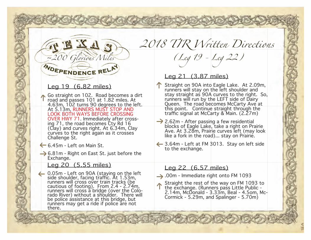
Leg 19 (6.82 miles)Go straight on 102. Road becomes a dirt road and passes 101 at 1.82 miles. At 4.63m, 102 turns 90 degrees to the left. At 5.13m, RUNNERS MUST STOP AND LOOK BOTH WAYS BEFORE CROSSING OVER HWY 71. Immediately after cross-ing 71, the road becomes Cty Rd 16 (Clay) and curves right. At 6.34m, Clay curves to the right again as it crosses Challenge St.6.45m - Left on Main St.6.81m - Right on East St. just before the Exchange. Leg 20 (5.55 miles)0.05m - Left on 90A (staying on the left side shoulder, facing traffic. At 1.53m, runners will cross over train tracks (be cautious of footing). From 2.4 - 2.74m, runners will cross a bridge (over the Colo-rado River) without a shoulder. There will be police assistance at this bridge, but runners may get a ride if police are not there.
Leg 21 (3.87 miles)Straight on 90A into Eagle Lake. At 2.09m, runners will stay on the left shoulder and stay straight as 90A curves to the right. So, runners will run by the LEFT side of Dairy Queen. The road becomes McCarty Ave at this point. Continue straight through the traffic signal at McCarty & Main. (2.27m)2.62m - After passing a few residential blocks of Eagle Lake, take a right on Prairie Ave. At 3.28m, Prairie curves left (may look like a fork in the road)... stay on Prairie.3.64m - Left at FM 3013. Stay on left side to the exchange.
Leg 22 (6.57 miles).00m - Immediate right onto FM 1093Straight the rest of the way on FM 1093 to the exchange. (Runners pass Little Public - 2.14m, McDonald - 3.33m, Beal - 4.5om, Mc-Cormick - 5.29m, and Spalinger - 5.70m)
~200 Glorious Miles2018 TIR Written Directions
(Leg 23 - Leg 28)
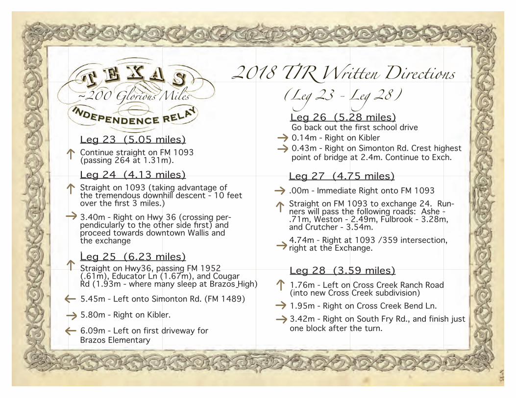
Leg 23 (5.05 miles)Continue straight on FM 1093 (passing 264 at 1.31m).
Leg 24 (4.13 miles)Straight on 1093 (taking advantage of the tremendous downhill descent - 10 feet over the first 3 miles.)3.40m - Right on Hwy 36 (crossing per-pendicularly to the other side first) and proceed towards downtown Wallis and the exchange.Leg 25 (6.23 miles)Straight on Hwy36, passing FM 1952 (.61m), Educator Ln (1.67m), and Cougar Rd (1.93m - where many sleep at Brazos High)-5.45m - Left onto Simonton Rd. (FM 1489)
5.80m - Right on Kibler.
6.09m - Left on first driveway for Brazos Elementary
Leg 26 (5.28 miles)Go back out the first school drive0.14m - Right on Kibler0.43m - Right on Simonton Rd. Crest highest point of bridge at 2.4m. Continue to Exch.
Leg 27 (4.75 miles).00m - Immediate Right onto FM 1093Straight on FM 1093 to exchange 24. Run-ners will pass the following roads: Ashe - .71m, Weston - 2.49m, Fulbrook - 3.28m, and Crutcher - 3.54m.4.74m - Right at 1093 /359 intersection, right at the Exchange.
Leg 28 (3.59 miles)1.76m - Left on Cross Creek Ranch Road (into new Cross Creek subdivision)1.95m - Right on Cross Creek Bend Ln.3.42m - Right on South Fry Rd., and finish just one block after the turn.
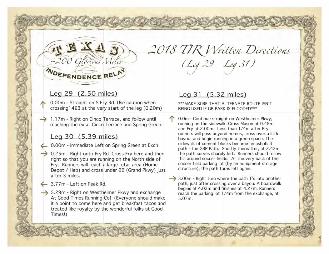
~200 Glorious Miles2018 TIR Written Directions
(Leg 29 - Leg 31)
Leg 29 (2.50 miles)0.00m - Straight on S Fry Rd. Use caution when crossing1463 at the very start of the leg (0.20m)
1.17m - Right on Cinco Terrace, and follow until reaching the ex at Cinco Terrace and Spring Green.
Leg 30 (5.39 miles)0.00m - Immediate Left on Spring Green at Exch0.25m - Right onto Fry Rd. Cross Fry here and thenright so that you are running on the North side of Fry. Runners will reach a large retail area (HomeDepot / Heb) and cross under 99 (Grand Pkwy) just after 3 miles.3.77m - Left on Peek Rd.5.29m - Right on Westheimer Pkwy and exchange At Good Times Running Co! (Everyone should makeit a point to come here and get breakfast tacos andtreated like royalty by the wonderful folks at GoodTimes!)
***MAKE SURE THAT ALTERNATE ROUTE ISN’TBEING USED IF GB PARK IS FLOODED***
0.0m - Continue straight on Westheimer Pkwy, running on the sidewalk. Cross Mason at 0.48mand Fry at 2.00m. Less than 1/4m after Fry, runners will pass beyond homes, cross over a littlebayou, and begin running in a green space. The sidewalk of cement blocks become an ashphaltpath - the GBP Path. Shortly thereafter, at 2.43mthe path curves sharply left. Runners should followthis around soccer fields. At the very back of the soccer field parking lot (by an equipment storagestructure), the path turns left again.
3.00m - Right turn where the path T’s into another path, just after crossing over a bayou. A boardwalkbegins at 4.03m and finishes at 4.27m. Runnersreach the parking lot 1/4m from the exchange, at 5.07m.
Leg 31 (5.32 miles)

~200 Glorious Miles2018 TIR Written Directions
(Leg 32 - Leg 33)
Leg 32 (6.79 miles)0.00m - Go straight up the George Bush Trail.Cross the new bridge at 1.55m. At 2.73m, runners will pass through the gate to begin running on Barker Clodine.
3.33m - Just after a little rise in the road (theBarker Resevoir Dam), runners will be 200metersfrom I-10. Immediately after coming down thissmall hill, runners will take a Right. Shortly aftertaking the right down this drive, runners will seewhere to pick up on the George Bush Path again.Near the very end of this leg, runners will seeHwy 6 (there have been changes since last yearthat make it near foolproof to get lost). Runnerswill see the dipsy-do that takes them underneathHwy 6 to finish at the start of the Terry Hershy Trail.
Leg 33 (6.61miles)It should be light out for nearly all the runnersfor leg 33, which should be helpful. The legs on park paths (in which there is no van assistance) arethe ones that people have a harder time navigating.So, it goes without saying that runners need to know their leg. 0.00m - Continue straight on the Terry HersheyTrail! At 1.47m, runners will come up to the road (Eldridge), will cross over the bayou, and do thedipsy-do to run under Eldridge (1.62m) & continue running EAST on the trail. See the diagram below:
After Eldridge the course runs along the northside of the bayou. Runners will run under DairyAshford Rd. at 3.07m and under Kirkwood at 4.16mAt 5.25 runners will come up off the trail and takea Right on Wilcrest. Runners will stay on Wilcrest until reaching the exchange at Wlicrest and Briar Forest.
Buffalo BayouTerry Hershey Trail
Terry Hershey Trail
Eldr
idge
Rd
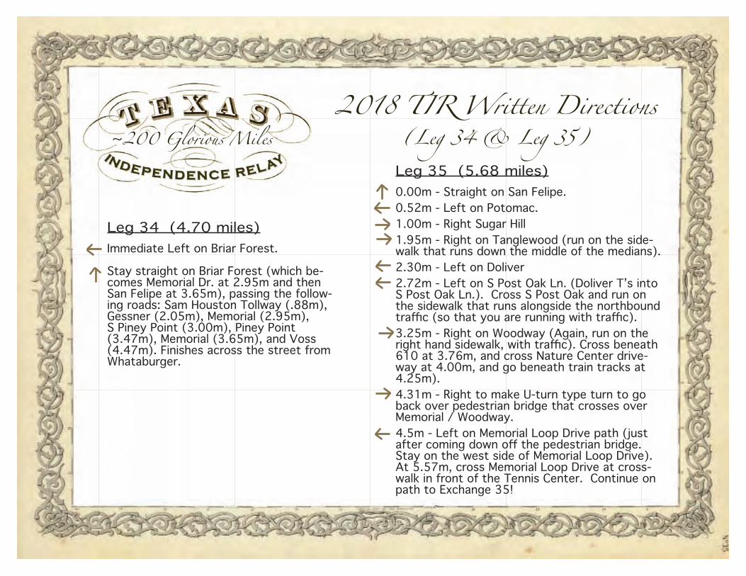
~200 Glorious Miles2018 TIR Written Directions
(Leg 34 & Leg 35)
Leg 34 (4.70 miles)Immediate Left on Briar Forest.
Stay straight on Briar Forest (which be-comes Memorial Dr. at 2.95m and then San Felipe at 3.65m), passing the follow-ing roads: Sam Houston Tollway (.88m), Gessner (2.05m), Memorial (2.95m), S Piney Point (3.00m), Piney Point (3.47m), Memorial (3.65m), and Voss (4.47m). Finishes across the street from Whataburger.
Leg 35 (5.68 miles)0.00m - Straight on San Felipe.0.52m - Left on Potomac.1.00m - Right Sugar Hill1.95m - Right on Tanglewood (run on the side-walk that runs down the middle of the medians).2.30m - Left on Doliver2.72m - Left on S Post Oak Ln. (Doliver T’s into S Post Oak Ln.). Cross S Post Oak and run on the sidewalk that runs alongside the northbound traffic (so that you are running with traffic).3.25m - Right on Woodway (Again, run on the right hand sidewalk, with traffic). Cross beneath 610 at 3.76m, and cross Nature Center drive-way at 4.00m, and go beneath train tracks at 4.25m).4.31m - Right to make U-turn type turn to go back over pedestrian bridge that crosses over Memorial / Woodway.4.5m - Left on Memorial Loop Drive path (just after coming down off the pedestrian bridge. Stay on the west side of Memorial Loop Drive). At 5.57m, cross Memorial Loop Drive at cross-walk in front of the Tennis Center. Continue on path to Exchange 35!

~200 Glorious Miles2018 TIR Written Directions
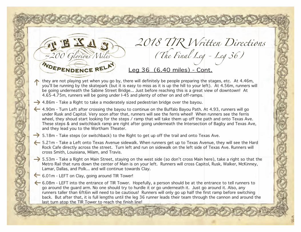
(The Final Leg - Leg 36)
Leg 36 (6.40 miles)0.00m - Continue on the Memorial Loop Path. DO NOT follow another runner. 0.25m miles into this leg, runners will cross over the driveway for the Memorial Park Golf Course and Beck’s Restaurant. As, runnersapproach a half mile (so, if a runner is running 10min pace, this would be right at 5minutes into the run), runners will notce a stop sign right next to the trail for southbound vehicular traffic on E Memorial Loop Dr. along with a crosswalk to cross the street.0.5m - Left onto Arnot St. (which is right here after crossing E Memorial Loop Dr.)0.72m - Right onto Crestwood (a 3-way stop)0.89m - Left onto Blossom, and continue until it appears to end at Jackson Hill (at the blue shed buiding) 2.51m - Right on Jackson Hill, crossing over to run on the other side against the NB traffic on Jackson Hill2.80m - Left to go OVER the pedestrian brige that goes over Memorial Dr. (But only go over this first bridge.)2.87m - Left after crossing over the first pedestrian bridge over Memorial Dr. Do NOT cross over the second pedestrian bridge that goes over the bayou. Stay on the widest / newest cement path. This will go under Waugh Dr. at 3.03 miles., under Montrose Blvd at 3.42m, by a couple of other newer pedestran bridges (3.48m).At 3.80m, the path crosses underneath Memorial, and goes around the HPD Memorial from ~4 to 4.25m. On the east side of the HPD memorial there is an option to take a path left (definitely a different path) - Do not take this left. Continue straight on the path to go back under Memorial Dr. and to run right next to Bayou. The path you want to stay on is lighter in color and has little miniature street lights alongside it. At 4.36m, runners will be across the bayou from Eleanor Tinsley Park, and there is a big music festival occuring this weekend, so if (continued)
they are not playing yet when you go by, there will definitely be people preparing the stages, etc. At 4.46m, you’ll be running by the skatepark (but it is easy to miss as it is up the hill to your left). At 4.56m, runners will be going underneath the Sabine Street Bridge... Just before reaching this is a great view of downtown! At 4.65-4.75m, runners will be going under I-45 and plenty of other entrances and off-ramps. 4.86m - Take a Right to take a moderately sized pedestrian bridge over the bayou.4.90m - Turn Left after crossing the bayou to continue on the Buffalo Bayou Path. At 4.93, runners will go under Rusk and Capitol. Very soon after that, runners will see the ferris wheel! When runners see the ferris wheel, they shoud start looking for the steps / ramp that will take them up off the path and onto Texas Ave. These steps & and switchback ramp are right after going underneath the Intersection of Bagby and Texas Ave, and they lead you to the Wortham Theater.5.18m - Take steps (or switchback) up off the trail and onto Texas Ave.5.21m - Take a Left onto Texas Avenue sidewalk. When runners get up to Texas Avenue, they will see the HardRock Cafe directly across the street. Turn left and run on sidewalk on the left side of Texas Ave. Runners will cross Smith, Louisiana, Milam, and Travis.5.53m - Take a Right on Main Street, staying on the west side (so don’t cross Main here), take a right so that the Metro Rail that runs down the center of Main is on your left. Runners will cross Capitol, Rusk, Walker, McKinney,Lamar, Dallas, and Polk... and will continue towards Clay.6.01m - LEFT on Clay, going around TIR Tower!6.08m - LEFT into the entrance of TIR Tower. Hopefully, a person should be at the entrance to tell runners to go around the guard arm. No one should try to hurdle it or go underneath it. Just go around it. Also, any runners taller than 6ft6in will need to be cautious! Runners will only go up half the first ramp before switching back. But after that, it is full lengths until the leg 36 runner leads their team through the cannon and around the last turn atop the TIR Tower to reach the finish line!
~200 Glorious Miles2018 TIR Written Directions
(The Final Leg - Leg 36)Leg 36 (6.40 miles) - Cont.
they are not playing yet when you go by, there will definitely be people preparing the stages, etc. At 4.46m, you’ll be running by the skatepark (but it is easy to miss as it is up the hill to your left). At 4.56m, runners will be going underneath the Sabine Street Bridge... Just before reaching this is a great view of downtown! At 4.65-4.75m, runners will be going under I-45 and plenty of other on and off-ramps. 4.86m - Take a Right to take a moderately sized pedestrian bridge over the bayou.4.90m - Turn Left after crossing the bayou to continue on the Buffalo Bayou Path. At 4.93, runners will go under Rusk and Capitol. Very soon after that, runners will see the ferris wheel! When runners see the ferris wheel, they shoud start looking for the steps / ramp that will take them up off the path and onto Texas Ave. These steps & and switchback ramp are right after going underneath the Intersection of Bagby and Texas Ave, and they lead you to the Wortham Theater.5.18m - Take steps (or switchback) to the Right to get up off the trail and onto Texas Ave.5.21m - Take a Left onto Texas Avenue sidewalk. When runners get up to Texas Avenue, they will see the HardRock Cafe directly across the street. Turn left and run on sidewalk on the left side of Texas Ave. Runners will cross Smith, Louisiana, Milam, and Travis.5.53m - Take a Right on Main Street, staying on the west side (so don’t cross Main here), take a right so that the Metro Rail that runs down the center of Main is on your left. Runners will cross Capitol, Rusk, Walker, McKinney,Lamar, Dallas, and Polk... and will continue towards Clay.6.01m - LEFT on Clay, going around TIR Tower!6.08m - LEFT into the entrance of TIR Tower. Hopefully, a person should be at the entrance to tell runners to go around the guard arm. No one should try to hurdle it or go underneath it. Just go around it. Also, any runners taller than 6ft6in will need to be cautious! Runners will only go up half the first ramp before switching back. But after that, it is full lengths until the leg 36 runner leads their team through the cannon and around the last turn atop the TIR Tower to reach the finish line!