Embed Size (px)
Citation preview
(!)htdc Oct 15, 2021
TO: Ms. Mary Alice Evans, Director Environmental Review Program
Hawaii Technology Development Corporation 521 Ala Moana Blvd, Ste 255
I 808-539-3806
Honolulu, Hawaii 96813 www.htdc.org
Office of Planning and Sustainable Development Department of Business, Economic Development and Tourism 235 South Beretania Street, Suite 702 Honolulu, HI 96813
SUBJECT: Environmental Impact Statement Preparation Notice for the First Responder Technology Campus Tax Map Keys: (1) 9-5-002:039 and (1) 9-5-002:057 Mililani, Island of O'ahu, Hawai'i
With this letter, the Hawai'i Technology Development Corporation (HTDC) hereby transmits the Environmental Impact Statement Preparation Notice (EISPN) for the First Responder Technology Campus Project, located at the subject site, in the 'Ewa and Wahiawa Districts on the island of O'ahu, for publication in the next edition of The Environmental Notice.
Pursuant to Hawai'i Revised Statutes §343-5(b) and Hawai'i Administrative Rules §11-200.1-14( d)(2), the HTDC has determined at the outset that an Environmental Impact Statement is required for the proposed project.
We have uploaded an electronic copy of this letter and the EISPN to your online submittal site.
Should you have any questions, please contact Len Higashi, Acting Executive Director, at (808) 539-3814, or by email at [email protected].
Len Higashi, Acting Executive Director
From: [email protected]: DBEDT OPSD Environmental Review ProgramSubject: New online submission for The Environmental NoticeDate: Monday, November 1, 2021 12:32:43 PM
Action Name
First Responders Technology Campus
Type of Document/Determination
Environmental impact statement preparation notice (EISPN)
HRS §343-5(a) Trigger(s)
(1) Propose the use of state or county lands or the use of state or county funds
Judicial district
Wahiawā, Oʻahu
Tax Map Key(s) (TMK(s))
(1) 9-5-002:039; (1) 9-5-002:057
Action type
Agency
Other required permits and approvals
Numerous
Proposing/determining agency
Hawai‘i Technology Development Corporation
Agency contact name
Len Higashi
Agency contact email (for info about the action)
Agency contact phone
(808) 539-3814
Agency address
521 Ala Moana Blvd, Suite 255Honolulu, HI 96813United StatesMap It
Public Scoping Meeting information
November 12, 2021/1:30 PM Virtual Meeting (sign up at https://frtc.konveio.com/)
Accepting authority
The Honorable David Y. Ige, Governor, State of Hawaii
Accepting authority contact name
David Ige
Accepting authority contact email or URL
https://governor.hawaii.gov/contact-us/contact-the-governor/
Accepting authority contact phone
(808) 586-0034
Accepting authority address
Executive ChambersState CapitolHonolulu, Hawaii 96817United StatesMap It
Was this submittal prepared by a consultant?
Yes
Consultant
SSFM International, Inc.
Consultant contact name
Jared Chang
Consultant contact email
Consultant contact phone
(808) 356-1242
Consultant address
501 Sumner Street, Suite 620Honolulu, Hawaii 96817United StatesMap It
Action summary
The Hawai‘i Technology Development Corporation (HTDC) proposes to develop a First ResponderTechnology Campus (FRTC) located in Mililani on the island of O‘ahu. The campus is proposed to belocated on State of Hawai‘i owned parcels identified as Tax Map Keys (1) 9-5-002: 039 and 057, whichare approximately 93-acres and 150-acres, respectively. The FRTC is envisioned to be a state-of-the-artfacility and will include various uses ranging from office, classroom and warehouse uses to fitnessfacilities, indoor shooting range and other various types of training facilities for first responder agencies.In addition, the FRTC will have accessory uses such as a hotel/dormitory and workforce housingdeveloped on the site. The FRTC will include facilities for multiple Federal, State of Hawai‘i and City andCounty of Honolulu (County) first responder agencies within one campus centrally located on O‘ahu forfirst responder training and disaster preparedness purposes.
Attached documents (signed agency letter & EA/EIS)
211029-FRTC-EISPN-vFinal.pdf211013-FRTC-EISPN-Transmittal-Letter_HTDC-letterhead-signed1.pdf

Action location map
FRTC-Project-Location1.zip
Authorized individual
Jared Chang
Authorization
The above named authorized individual hereby certifies that he/she has the authority to make thissubmission.
Hawai‘i Technology Development Corporation First Responder Technology Campus
i
Hawai‘i Technology Development Corporation First Responder Technology Campus
ii
Table of Contents Introduction .................................................................................................... 1
Background ................................................................................................. 1 Determination to Prepare an EIS ................................................................ 3 EISPN Review Process and Public Scoping Meeting ................................... 7
Project Description .......................................................................................... 8 Project Setting and Description .................................................................. 8 Purpose and Need for the Proposed Action ............................................... 8 Proposed Action ........................................................................................ 10 Development Schedule ............................................................................. 14 Required Permits and Approvals .............................................................. 20
Project Setting ............................................................................................... 21 Climate ...................................................................................................... 21 Geology and Topography .......................................................................... 21 Soils ........................................................................................................... 21 Natural Hazards ........................................................................................ 23 Ground, Surface, and Marine Waters ....................................................... 23 Flora and Fauna ......................................................................................... 25 Air Quality and Water Quality ................................................................... 25 Noise ......................................................................................................... 25 Utilities, Infrastructure and Traffic ........................................................... 25
Socio-Economic Characteristics ................................................................ 26 Public Facilities and Services ..................................................................... 27 Cultural Practices and Resources .............................................................. 28 Historic and Archaeological Resources ..................................................... 28 Land Use Plans and Policies ...................................................................... 35
Hawai‘i State Plan ........................................................................ 35 State Land Use Classification ....................................................... 36 Coastal Zone Management Act, HRS Chapter 205A.................... 36 Hawai‘i 2050 Sustainability Plan ................................................. 42 State Historic Preservation .......................................................... 42 City and County of Honolulu – General Plan ............................... 42 Land Use Ordinance .................................................................... 46 Central O‘ahu Sustainable Communities Plan ............................. 46 Special Management Area .......................................................... 49
Ola: O‘ahu Resilience Strategy .................................................... 49
Hawai‘i Technology Development Corporation First Responder Technology Campus
iii
Project Alternatives ....................................................................................... 50 No-Action Alternative ............................................................................... 50 Delayed Action .......................................................................................... 50 Alternative Sites ........................................................................................ 50
Agencies and Parties to be Consulted ............................................................ 51 Early Consultation ..................................................................................... 51 EISPN Consultation.................................................................................... 52
References .................................................................................................... 56
List of Figures Figure 1: Project Location Map .................................................................................. 9 Figure 2: Site Plan of Parcel 057 .............................................................................. 16 Figure 3: Site Plan of Parcel 039 .............................................................................. 17 Figure 4: Parcel 057 Phasing Plan ............................................................................ 18 Figure 5: Parcel 039 Phasing Plan ............................................................................ 19 Figure 6: Soils Map ................................................................................................... 22 Figure 7: Flood Hazard Map ..................................................................................... 24 Figure 8: Identified Historic Properties in Parcel 057 .............................................. 33 Figure 9: Identified Historic Properties in Parcel 039 .............................................. 34 Figure 10: State Land Use District Map ..................................................................... 37 Figure 11: City and County of Honolulu Zoning Map ................................................. 47 Figure 12: COSCP Urban Land Use Map ..................................................................... 48
List of Tables Table 1: Programmed Spaces ............................................................................................. 11 Table 2: List of Potential Required Permits and Approvals ................................................ 20 Table 3: Population Demographics ..................................................................................... 26 Table 4: Historic Properties Identified by CSH .................................................................... 31 Table 5: List of Agencies and Parties to be Consulted ........................................................ 52
Hawai‘i Technology Development Corporation First Responder Technology Campus
iv
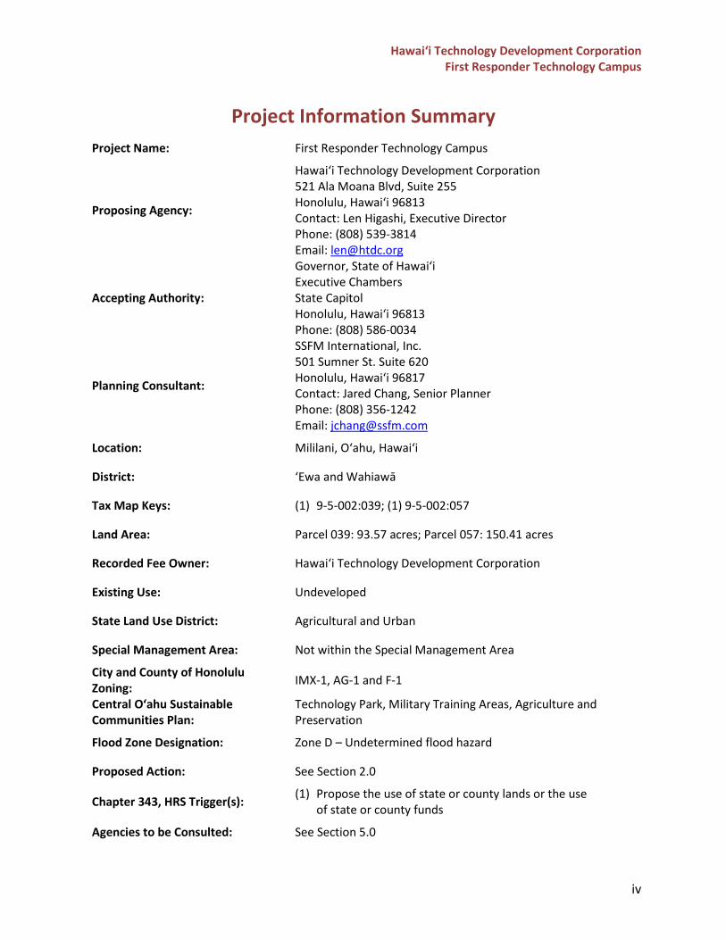
Project Information Summary
Project Name: First Responder Technology Campus
Proposing Agency:
Hawai‘i Technology Development Corporation 521 Ala Moana Blvd, Suite 255 Honolulu, Hawai‘i 96813 Contact: Len Higashi, Executive Director Phone: (808) 539-3814 Email: [email protected]
Accepting Authority:
Governor, State of Hawai‘i Executive Chambers State Capitol Honolulu, Hawai‘i 96813 Phone: (808) 586-0034
Planning Consultant:
SSFM International, Inc. 501 Sumner St. Suite 620 Honolulu, Hawai‘i 96817 Contact: Jared Chang, Senior Planner Phone: (808) 356-1242 Email: [email protected]
Location: Mililani, O‘ahu, Hawai‘i
District: ‘Ewa and Wahiawā
Tax Map Keys: (1) 9-5-002:039; (1) 9-5-002:057
Land Area: Parcel 039: 93.57 acres; Parcel 057: 150.41 acres
Recorded Fee Owner: Hawai‘i Technology Development Corporation
Existing Use: Undeveloped
State Land Use District: Agricultural and Urban
Special Management Area: Not within the Special Management Area
City and County of Honolulu Zoning: IMX-1, AG-1 and F-1
Central O‘ahu Sustainable Communities Plan:
Technology Park, Military Training Areas, Agriculture and Preservation
Flood Zone Designation: Zone D – Undetermined flood hazard
Proposed Action: See Section 2.0
Chapter 343, HRS Trigger(s): (1) Propose the use of state or county lands or the use of state or county funds
Agencies to be Consulted: See Section 5.0
Hawai‘i Technology Development Corporation First Responder Technology Campus
v
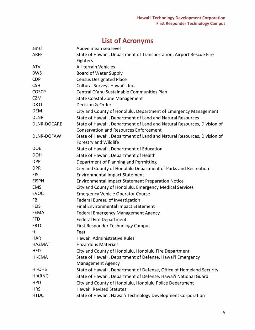
List of Acronyms amsl Above mean sea level ARFF State of Hawai‘i, Department of Transportation, Airport Rescue Fire
Fighters ATV All-terrain Vehicles BWS Board of Water Supply CDP Census Designated Place CSH Cultural Surveys Hawai‘i, Inc. COSCP Central O‘ahu Sustainable Communities Plan CZM State Coastal Zone Management D&O Decision & Order DEM City and County of Honolulu, Department of Emergency Management DLNR State of Hawai‘i, Department of Land and Natural Resources DLNR-DOCARE State of Hawai‘i, Department of Land and Natural Resources, Division of
Conservation and Resources Enforcement DLNR-DOFAW State of Hawai‘i, Department of Land and Natural Resources, Division of
Forestry and Wildlife DOE State of Hawai‘i, Department of Education DOH State of Hawai‘i, Department of Health DPP Department of Planning and Permitting DPR City and County of Honolulu Department of Parks and Recreation EIS Environmental Impact Statement EISPN Environmental Impact Statement Preparation Notice EMS City and County of Honolulu, Emergency Medical Services EVOC Emergency Vehicle Operator Course FBI Federal Bureau of Investigation FEIS Final Environmental Impact Statement FEMA Federal Emergency Management Agency FFD Federal Fire Department FRTC First Responder Technology Campus ft. Feet HAR Hawai‘i Administrative Rules HAZMAT Hazardous Materials HFD City and County of Honolulu, Honolulu Fire Department HI-EMA State of Hawai‘i, Department of Defense, Hawai‘i Emergency
Management Agency HI-OHS State of Hawai‘i, Department of Defense, Office of Homeland Security HIARNG State of Hawai‘i, Department of Defense, Hawai‘i National Guard HPD City and County of Honolulu, Honolulu Police Department HRS Hawai‘i Revised Statutes HTDC State of Hawai‘i, Hawai‘i Technology Development Corporation
Hawai‘i Technology Development Corporation First Responder Technology Campus
vi
LUO Land Use Ordinance MOU Memorandum of Understanding MTP Mililani Technology Park NPDES National Pollutant Discharge Elimination System NWI National Wetlands Inventory OETS State of Hawai‘i, Department of Accounting and General Services,
Office of Enterprise Technology Services PRU Plan Review Use PSD State of Hawai‘i, Department of Public Safety US-OHSI U.S. Office of Homeland Security Investigations USGS U.S. Geological Survey SHPD State Historic Preservation Division SLUC State Land Use Commission SMA Special Management Area UH University of Hawai‘i at Mānoa USFWS U.S. Fish and Wildlife Service USMS U.S. Marshals Service UTV Utility Terrain Vehicles
Hawai‘i Technology Development Corporation First Responder Technology Campus
1
INTRODUCTION Background
The Hawai‘i Technology Development Corporation (HTDC) proposes to develop a First Responder Technology Campus (FRTC) located in Mililani on the island of O‘ahu. The campus is proposed to be located on State of Hawai‘i owned parcels identified as Tax Map Keys (1) 9-5-002: 039 and 057, which are approximately 93-acres and 150-acres, respectively. The FRTC is envisioned to be a state-of-the-art facility and will include various uses ranging from office, classroom and warehouse uses to fitness facilities, indoor shooting range and other various types of training facilities for first responder agencies. In addition, the FRTC will have accessory uses such as a hotel/dormitory and workforce housing developed on the site. The FRTC will include facilities for multiple Federal, State of Hawai‘i and City and County of Honolulu (County) first responder agencies within one campus centrally located on O‘ahu for first responder training and disaster preparedness purposes. In 1985, a Final Environmental Impact Statement (FEIS) for the Hawai‘i Technology Park (now known as Mililani Technology Park) was prepared by Belt Collins & Associates for Oceanic Properties, Inc. (a subsidiary of Castle & Cooke, Inc.), which proposed the use of Parcel 057 for Phase II of the Mililani Technology Park (MTP) development. As stated in the FEIS, Phase II was proposed to include 115-acres of “campus industrial” use and 10-acres of open space use. Campus industrial use was described as those involving high-technology operations or closely related activities, such as electronics, instruments, telecommunications, bio-technology, renewable energy, manufacturing and assembly, research and development, marketing and training, and ancillary warehousing and administrative functions. The uses proposed at the FRTC will differ significantly from what was proposed in the 1985 FEIS for the Hawai‘i Technology Park. In 2014, the Hawai‘i State Legislature appropriated funds for the acquisition of Phase II of the MTP (Parcels 057 and 039) to create the FRTC. In 2017, Pryzm Consulting LLC prepared a Due Diligence Report prior to HTDC’s acquisition of Parcel 057 from Castle and Cooke. The report included an assessment of a conceptual master plan prepared by the University of Hawai‘i at Mānoa (UH) Community Design Center, which included ten (10) State and County agencies to be located at the campus. The Due Diligence Report found that roads, water, sewer, and electrical infrastructure would need to be developed as none were currently provided to the site and development would require significant improvements to be made. Other potential concerns for development included the required land use entitlements and the potential for any historic properties or cultural resources on site. In 2021, HTDC conducted a multi-day virtual charrette for the preparation of an updated master plan for the FRTC. The charrette involved representatives from nineteen (19) Federal, State and County agencies to understand their organization’s training and spatial needs, opportunities, and constraints. Through the charrette process, the agencies were able to: understand the
Hawai‘i Technology Development Corporation First Responder Technology Campus
2
needs of their partner agencies and opportunities for collaboration, build a collective vision of what the project can be, and understand the commitment of resources from each agency that was needed to complete the project. At the end of the process, an updated conceptual master plan was created that addressed the needs of each agency and provided facilities that could be shared amongst all of those located at the FRTC. Below is a summary of each charrette session. Charrette Session 1: On January 20, 2021, the first charrette session was held to introduce the client, project team, and stakeholder agencies; provide an overview and orientation of the project; and explain the charrette process to the stakeholders. During this session, the project team oriented the stakeholders to the project site by providing regional context, surrounding land uses, climate data, topography, infrastructure and access, and the archaeological and historical setting of the area. The conceptual master plan prepared by UH was shared with the stakeholders. The project team also identified potential uses that may be located at the FRTC that would be further evaluated in the following charrette sessions. Three stakeholder champions from the U.S. Department of Homeland Security, Hawai‘i Emergency Management Agency, and the Honolulu Fire Department took part in a panel discussion on the needs and opportunities that their agency would seek at the FRTC. Charrette Session 2: On February 2, 2021, the second charrette session was held to confirm individual stakeholder needs; explore stakeholder interests in shared facilities; and prepare the stakeholders for the individual meetings/interviews that would take place as Charrette Session 3. During this session, each agency had the opportunity to present and discuss their priorities, visions, and goals for relocating to the FRTC; the potential facilities and activities that would be located at the FRTC; and the types of facilities that they would hope to share with other agencies. The project team presented a site analysis, which showed the existing topography, access and infrastructure on the site, and the proposed program areas based on the existing conditions. Charrette Session 3: From February 3, 2021, to February 26, 2021, the project team conducted individual meetings/interviews with each agency to understand their specific needs and to refine their priorities for relocating to the FRTC. This session also included a series of small-group meetings with agencies interested in defining basic parameters for different shared facilities (e.g., shooting ranges, training areas, conference space, etc.). The information gathered from this session provided the basis for the conceptual plans and designs shared in Charrette Session 4 and 5. Charrette Session 4: On March 9, 2021, the fourth charrette session was held to review, discuss, and refine the revised master plan that was prepared based on the information gathered throughout the charrette sessions. The project team shared the vision and goals of the campus and the method and analysis that was used to prepare the master plan. The team also presented the conceptual program space dedicated to each agency. Stakeholders were able to participate in live polling to provide their feedback and thoughts on the revised master plan.
Hawai‘i Technology Development Corporation First Responder Technology Campus
3
Charrette Session 5: On March 25, 2021, the fifth and final charrette session was held to finalize the master plan and to outline the next steps for the project and the stakeholders. The project team presented conceptual renderings of the site plan and massing of buildings at the FRTC. The session concluded with identifying the next steps for the project, which included drafting Memorandums of Understanding (MOUs) with the agencies, preparing the Environmental Impact Statement (EIS), applying for the applicable land use approvals and entitlements, conducting engineering studies, and drafting of funding requests.
Determination to Prepare an EIS
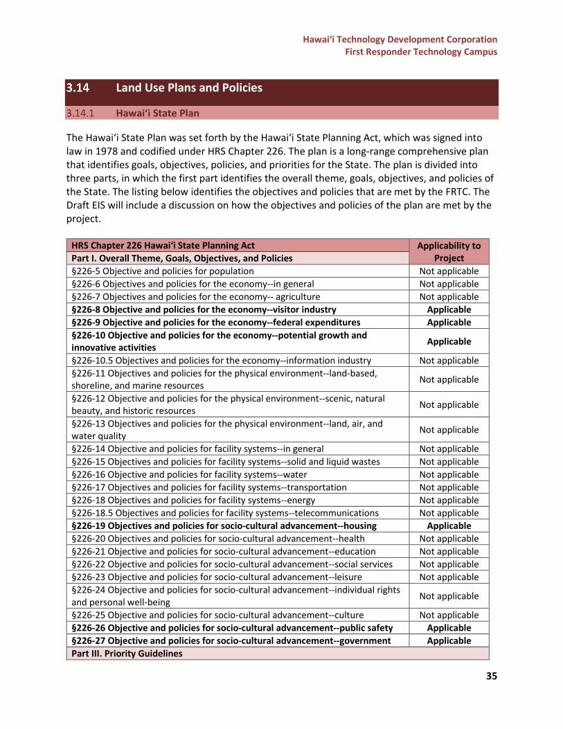
Per Hawai‘i Administrative Rules (HAR) §11-200.1-14(d)(2), if the proposed action is not eligible for an exemption and is required to prepare an Environmental Assessment, a proposing agency may determine through its judgement and experience that an Environmental Impact Statement (EIS) is likely to be required, and thus may choose to prepare an EIS in accordance with HAR §11-200.1-23 – 30 starting with the preparation of an Environmental Impact Statement Preparation Notice (EISPN). To determine whether a proposed action may have a significant effect on the environment, and therefore require an EIS, the proposing agency must review the proposed action against the significance criteria set forth in HAR §11-200.1-13(b). The following discussion is based on an initial review of the proposed action against the significance criteria.
(1) Irrevocably commit a natural, cultural, or historic resource;
A Draft Archaeological Literature Review and Field Inspection Report was prepared by Cultural Surveys Hawai‘i, Inc. (CSH) to assess the potential and known cultural and historic resources within the project site (see Section 3.13 in this EISPN). Based on initial findings, it is unlikely that there are traditional Hawaiian historic properties within Parcel 057 as the plantation-related historic properties identified were not in good condition and would likely only be significant for their information potential. CSH recommended that formal identification of existing ditches surveyed should be conducted prior to any projects that may impact them, and that two historic properties identified within the gulch should be further investigated to determine function, age, extent, and significance.
Parcel 039 contains the Waikakalaua Ditch complex which is anticipated to have possible significance due to potential historic properties identified during the field inspection. Thus, it is recommended that further archaeological investigation in consultation with the State Historic Preservation Division (SHPD) should be done prior to any projects being planned for this parcel. As a part of the Draft EIS process, consultation with SHPD will be continued to determine potential impacts and mitigation measures necessary to avoid or minimize the impacts to cultural or historic resources within the project area. Consultation with the O‘ahu Island Burial Council and the cultural/lineal descendants of the area will also be conducted during the Draft EIS process.
Hawai‘i Technology Development Corporation First Responder Technology Campus
4
(2) Curtail the range of beneficial uses of the environment;
The range of beneficial uses of the environment is not anticipated to be significantly curtailed by the proposed action. Parcel 057 was previously set aside for the development of MTP Phase II, and thus has remained undeveloped. Parcel 039 was not previously included in any development plans and has remained undeveloped since the plantation era. The development of the FRTC is consistent with the Central O‘ahu Sustainable Communities Plan (COSCP) adopted on March 30, 2021 and is identified in Section 3.14.8 and the Urban Land Use Map in the COSCP.
(3) Conflict with the State's environmental policies or long-term environmental goals
established by law; The project is expected to be consistent with, and supportive of, Hawai‘i Revised Statutes (HRS) Chapter 344 purpose, policies, and guidelines. The project is also consistent with State policies and goals regarding climate change and mitigation of sea-level rise impacts, as it will relocate multiple first responder agencies’ headquarters, training centers, and offices out of O‘ahu’s inundation zone into a centralized location that is outside of both the tsunami inundation zone and the 3.2-foot sea-level rise exposure area.
(4) Have a substantial adverse effect on the economic welfare, social welfare, or
cultural practices of the community and State; The development of the FRTC is expected to create jobs and have a positive impact on the region’s economic development, as it will allow for a live-work-play community within Central O‘ahu. The accessory uses that will be included in the development of the FRTC will provide more commercial and retail opportunities in the area that may benefit adjacent users and the surrounding community. In addition, the development of the workforce housing and hotel/dormitory will support the housing and overnight accommodation needs of the island, the government/military demands of nearby Scholfield Barracks, Wheeler Army Airfield, and surrounding businesses in MTP Phase I. The development of training facilities at the FRTC will provide accommodations for first responder agencies to properly train their employees and reduce the need to send trainees to U.S. mainland facilities.
Hawai‘i Technology Development Corporation First Responder Technology Campus
5
(5) Have a substantial adverse effect on public health; The project is not anticipated to have a substantial adverse effect on public health, and instead would provide beneficial impacts to public health through the training of first responders. The Draft EIS will identify and discuss potential impacts to public health, such as short term construction-related impacts, long term operational impacts, and mitigation measures as appropriate.
(6) Involve adverse secondary impacts, such as population changes or effects on
public facilities;
The development of the FRTC and its accessory use will impact the region’s population and surrounding public facilities. The FRTC would result in increases to traffic, infrastructure demands, and intensity of uses in the area. Accessory uses would include proposed workforce housing and a new hotel. FRTC will have multiple first responder agencies from the Federal, State, and County level located on one campus which is anticipated to increase the opportunities and efficiency of training operations, improve emergency coordination across agencies, and result in other public benefits A socio-economic impact assessment and a traffic impact assessment are being prepared for the Draft EIS to analyze information on current demographic and economic patterns and the projected growth in population and traffic as it relates to the development of the FRTC. The results of these studies and any potential impacts will be discussed in the Draft EIS.
(7) Involve a substantial degradation of environmental quality;
The project is not anticipated to substantially degrade the environmental quality of the site and surrounding area. The Draft EIS will include assessments of short-term construction-related impacts (e.g., noise, air quality) and necessary mitigations to minimize impacts on the surrounding built and natural environments. Formerly, the land was in agricultural at the beginning of the 20th century and today is an undeveloped dense forest of mature Albizia trees and other species.
(8) Be individually limited but cumulatively have substantial adverse effect upon the
environment or involves a commitment for larger actions;
HTDC anticipates the construction of the FRTC to occur in multiple phases over an approximate 15-year period starting in the year 2023. The FRTC will include many first responder agencies and each agency will need to secure funding and develop future plans for facilities at FTRC. These plans are likely to include commitments for larger actions by each agency which may include relocation of operations and facilities, increases in operations or facility spaces, or both. Secondary impacts on the surrounding regional
Hawai‘i Technology Development Corporation First Responder Technology Campus
6
population and infrastructure demands are anticipated. The FRTC will also include land set aside for private development of accessory uses, including a hotel and business mixed use/workforce housing development. It is intended that proposals will be solicited from hotel developers, business mixed use developers and housing developers to build and lease these areas from the State, which will minimize the funding needed from the State to design, operate, and maintain these facilities, while still providing these beneficial uses to the surrounding community and the FRTC.
(9) Have a substantial adverse effect on a rare, threatened, or endangered species,
or its habitat;
Biological resource surveys are being conducted for this project and will be included in the Draft EIS. The report will include the identification of flora and fauna species and habitats in the project area, including the identification of any Federal or State-listed threatened or endangered species. In addition, the report will address the impacts of the project and propose minimization and mitigation measures, as appropriate.
(10) Have a substantial adverse effect on air or water quality or ambient noise levels;
Air and water quality assessment reports are being prepared for this project and will be included in the Draft EIS. The report will analyze the proposed construction and operational impacts of the FRTC to the air and water quality of the surrounding area and will identify necessary minimization and mitigation measures, as appropriate.
(11) Have a substantial adverse effect on or be likely to suffer damage by being located in an
environmentally sensitive area such as a flood plain, tsunami zone, sea level rise exposure area, beach, erosion-prone area, geologically hazardous land, estuary, fresh water, or coastal waters;
The FRTC is located outside of both the tsunami evacuation zone and the 3.2-foot sea level rise exposure area, which makes the site an ideal location for the first responder agencies. Many of the first responder agencies’ existing headquarters, offices, and training facilities are within tsunami evacuation zones, flood hazard zones identified in the Federal Emergency Management Agency’s Flood Insurance Rate Maps, and/or the 3.2-foot sea level rise exposure area, which put many of the agencies and their facilities at risk to be inundated by natural disasters and sea level rise.
(12) Have a substantial adverse effect on scenic vistas and viewplanes, during day or night,
identified in county or state plans or studies; or
The Draft EIS will include an analysis of the project’s visual impacts and discuss potential mitigation measures, as appropriate.
Hawai‘i Technology Development Corporation First Responder Technology Campus
7
(13) Require substantial energy consumption or emit substantial greenhouse gases. Infrastructure impacts and related energy consumption, as well as greenhouse gas emissions, will be identified and analyzed in the Draft EIS.
Based on the range and intensity of the uses proposed at the FRTC and on the significance criteria set forth in HAR Chapter 11-200.1.-13, it is anticipated that the FRTC development and actions proposed in this project may have the potential to result in significant impacts to the environment and will include significant impacts that were not previously addressed in the 1985 FEIS. As such, a Programmatic EIS is being prepared to provide an analysis of the potential project-related impacts and proposed mitigation measures, commencing with the preparation of this EISPN.
EISPN Review Process and Public Scoping Meeting
This document has been prepared in accordance with the requirements of Hawai‘i’s Environmental Protection Act, HRS Chapter 343, and HAR §11-200.1-23. Following the publication of this EISPN in The Environmental Notice published by the State’s Environmental Review Program is a 30-day public review and comment period, in which the public can provide written comments regarding the environmental effects of the proposed action. All written comments and responses provided will be included in the Draft EIS. In addition, an EIS public scoping meeting is required to be held during the 30-day public review period, per HAR §11-200.1-23. Due to public health concerns and the State and County’s restrictions on social gatherings, a virtual public scoping meeting will be held on Friday, November 12, 2021, from 1:30PM to 3:00PM. A link to sign up for the meeting will be included in the publication of the EISPN.

Hawai‘i Technology Development Corporation First Responder Technology Campus
8
PROJECT DESCRIPTION Project Setting and Description
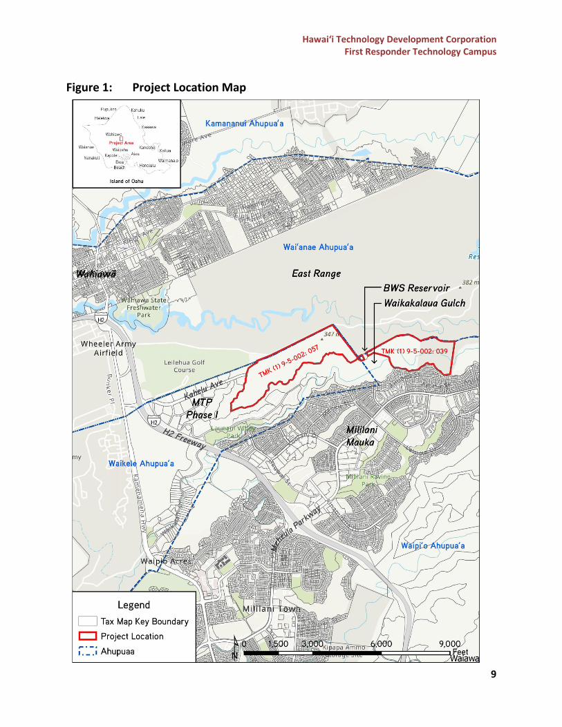
The FRTC would be located on approximately 243 acres of land between Mililani and Wahiawā on the island of O‘ahu, on State of Hawai‘i owned parcels identified as Tax Map Keys (1) 9-5-002: 039 and 057, which are approximately 93-acres and 150-acres, respectively. A majority of Parcel 057 is in the Waikele Ahupua‘a, while a portion of Parcel 057 and Parcel 039 is in the Waipio Ahupua‘a (see Figure 1). The project site is currently undeveloped, former agricultural land that is bounded by Leilehua Golf Course and Federally owned East Range to the north, MTP Phase I to the west, Waikakalaua Gulch to the south, and undeveloped conservation lands to the east. A Board of Water Supply (BWS) reservoir is located between the two parcels on a separate tax map key parcel. Other surrounding landmarks and uses adjacent to the site include the Wheeler Army Airfield, the town of Wahiawā, and residential developments including Launani Valley and Mililani Mauka. The project site is located east of the H-2 Freeway and Kamehameha Highway. Existing access to the site is from Kahelu Avenue, which runs through MTP Phase I. The site currently does not have any existing paved roads, utilities, or site infrastructure for water, power, communications, wastewater, or drainage.
Purpose and Need for the Proposed Action
In 2014, the Hawai‘i State Legislature appropriated funds for the acquisition of Phase II of the MTP to create the FRTC. The need for the FRTC was derived from the overlapping needs of first responder agencies, such as the need for a centralized headquarters by the Sheriff’s Division and Emergency Medical Services (EMS), and the need for joint-training facilities for sheriffs, police, fire fighters, and the National Guard. In addition, several locations of first responder headquarters, offices, airfields, and training facilities are within O‘ahu’s tsunami evacuation zones, flood hazard zones identified in the Federal Emergency Management Agency’s Flood Insurance Rate Maps, and/or the 3.2-foot sea level rise exposure area modeled by the University of Hawai‘i Coastal Geology Group, which put many of the agencies and their facilities at risk to be inundated by natural hazards, storm events and sea level rise.
Hawai‘i Technology Development Corporation First Responder Technology Campus
9
Figure 1: Project Location Map
Hawai‘i Technology Development Corporation First Responder Technology Campus
10
The proposed FRTC would provide a centralized location for first responder agencies’ operations and training. Locating multiple agencies in one campus will provide more opportunities for integration, coordination, and cross-training between agencies from the Federal, State, and County level, while decreasing the cost for these agencies to develop their own individual facilities. First responder agencies engaged for this project have identified a need for updated facilities, increased administrative space and in-state training facilities, among other ancillary uses. First responder agencies often send their trainees to out-of-state training facilities, which comes at a significant cost to each agency. In addition, the centralized location away from areas vulnerable to natural disasters and climate change hazards will comply with plans, policies, and regulations set forth for the resilience and sustainability of the State and the island of O‘ahu, included in the Hawai‘i 2050 Sustainability Plan and Ola: O‘ahu Resilience Strategy. This will minimize the potential of these agencies to be impacted by tsunamis and sea-level rise, as well as increase our State’s preparedness for responding to disasters.
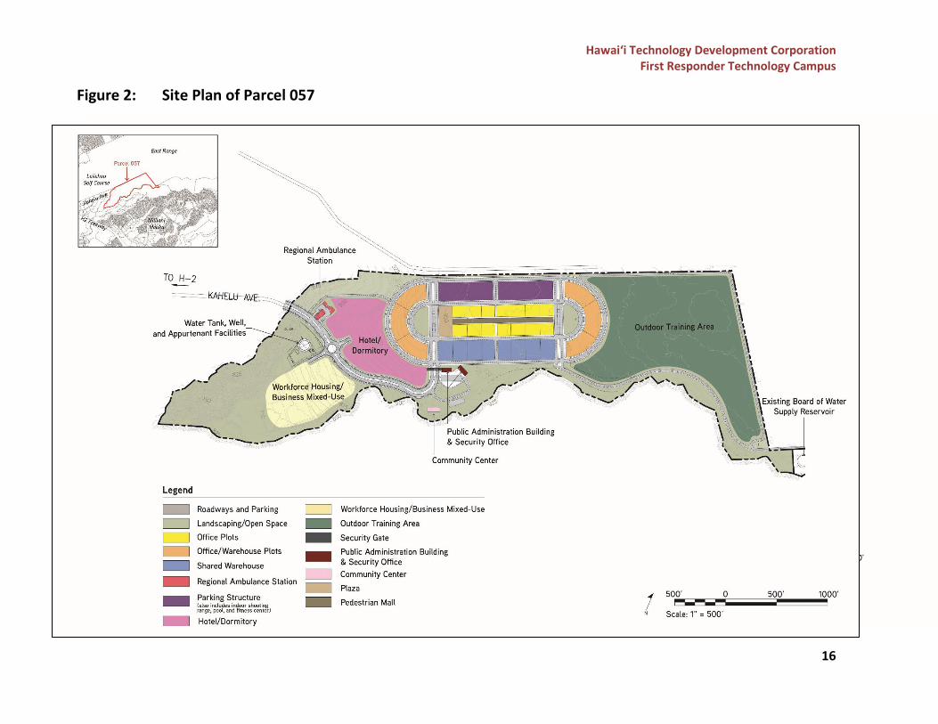
Proposed Action
HTDC plans to develop the 243 acres of land for the FRTC and accessory uses. The conceptual site plans are shown in Figures 2 and 3. This will be the first campus of its kind in the State of Hawai‘i. At full buildout, the FRTC is anticipated to serve nineteen (19) different first responder agencies consisting of Federal, State and County agencies. A listing of anticipated agencies participating in the development of this project includes:
1. U.S. Office of Homeland Security Investigations (US-OHSI) 2. U.S. Marshals Service (USMS) 3. Federal Bureau of Investigation (FBI) 4. Federal Fire Department (FFD) 5. State of Hawai‘i, Department of Business and Economic Development, Hawai‘i
Technology Development Corporation (HTDC) 6. State of Hawai‘i, Department of Defense, Hawai‘i Emergency Management Agency (HI-
EMA) 7. State of Hawai‘i, Department of Defense, Hawai‘i National Guard (HIARNG) 8. State of Hawai‘i, Department of Defense, Office of Homeland Security/Fusion Center
(HI-OHS) 9. State of Hawai‘i, Department of Transportation, Airport Rescue Fire Fighters (ARFF) 10. State of Hawai‘i, Department of Transportation, Harbor Police 11. State of Hawai‘i, Department of Land and Natural Resources, Division of Forestry and
Wildlife (DLNR-DOFAW) 12. State of Hawai‘i, Department of Land and Natural Resources, Division of Conservation
and Resources Enforcement (DLNR-DOCARE) 13. State of Hawai‘i, Department of Public Safety (PSD)
Hawai‘i Technology Development Corporation First Responder Technology Campus
11
14. State of Hawai‘i, Department of Accounting and General Services, Office of Enterprise Technology Services (OETS)
15. University of Hawai‘i Community College System 16. City and County of Honolulu, Department of Emergency Management (DEM) 17. City and County of Honolulu, Emergency Management Services (EMS) 18. City and County of Honolulu, Honolulu Police Department (HPD) 19. City and County of Honolulu, Honolulu Fire Department (HFD)
The main core of the FRTC (located on Parcel 057) will include office and warehouse spaces for agencies, shared facility space, and accessory uses. Table 1 provides a breakdown of the total space provided for each use followed by a brief description of the FRTC’s proposed spaces.
Table 1: Programmed Spaces
Programmed Spaces Total Size (Approx. in Square Feet) Dedicated Spaces for Agencies Office Spaces 368,000 Classroom Spaces 42,400 Warehouse Spaces 293,000 Parking Structure 134,200 Shared Facility Space Conference and Training Spaces 63,000 Dining and Food Facilities 20,000 Fitness Facilities 76,000 Indoor Shooting Ranges 99,000 Facility Management and Support Spaces 7,000 Overnight Accommodations 209,000
Office Spaces Office and administrative space will be provided in the main core of the FRTC on Parcel 057. The office space provided to each agency will range in size and uses as some spaces will serve as the main headquarters for agencies, while others will function as satellite offices. The types of users will also differ between each agency, and may include administrative staff, training staff, field personnel, and new recruits. Classroom Spaces Classroom spaces will be provided to agencies for teaching and training new recruits. The classroom space provided to each agency will range in size and uses as some spaces will provide a hands-on training setting for physical activities, while others may provide a traditional classroom setting for gatherings.
Hawai‘i Technology Development Corporation First Responder Technology Campus
12
Warehouse Spaces Warehouse spaces will be provided to agencies and are anticipated to primarily function as storage spaces. The size of warehouse spaces allocated to each agency will differ depending on the items to be stored or other agency needs. Most agencies will have a dedicated amount of space within one shared warehouse, which will be located on the south-east portion of the site, while others will have their own dedicated warehouse due to the function or types of items to be stored. The shared warehouse will securely store items such as training equipment, weapons, operational equipment and tools, and other necessary items. HPD will primarily use their dedicated warehouse as storage space for sensitive materials, which requires an extra level of security to control access. Parking Structure A parking structure is proposed to serve most of the parking and vehicle storage needs for FRTC. The parking structure would be located on the north portion of the site. The parking structure includes dedicated space for agency vehicles and parking spaces provided for employees. Stored agency vehicles will be in a secured portion of the parking structure, and may include training vehicles, all-terrain vehicles (ATVs), utility terrain vehicles (UTVs), vans, jet skis and watercrafts, trailers, sleds, and other types of vehicles. Conference and Indoor Training Spaces The conference and training spaces will be within a shared facility that will provide spaces ranging from small meeting rooms that seat 12 people to a large auditorium that seats 450 people. The small to medium-sized rooms will be used for meetings, classrooms, and a conference hall, which will be a set of rooms that can be combined in various configurations. The larger rooms will include a lecture hall and auditorium. A portion of the anticipated training space may also be designed to accommodate future virtual reality and simulated training functionality. Outdoor Training Spaces Multiple outdoor training spaces are proposed at FRTC for use by the different first responder agencies. These outdoor training spaces may include the following types of facilities. Towers for communications and training, such as an observation tower, radio tower (microwave and satellites), cellular tower, emergency warning siren equipment and rappelling tower. Emergency response training, such as for hazardous materials (HAZMAT) and flashover, rail car or station emergencies, collapsed building/rubble pile, mock urban scenarios, burn training for fire fighters, tactical raid and breaching. Driver training facilities and Emergency Vehicle Operator Course (EVOC) training which would include a large, flat, paved surface for driver training. This may also include areas for emergency skid pad training and vehicle extraction training.
Hawai‘i Technology Development Corporation First Responder Technology Campus
13
Physical training facilities such as an obstacle course for physical fitness training and testing, running track, and search and rescue facilities. Dining and Food Facilities The dining facility will be a shared facility that will function as a cafeteria and kitchen space. The food service space will have office space for the food service director and nutritionist; prep and production space; dry, refrigerated, and freezer storage; washing space; and receiving and storage space. Fitness Facilities The shared fitness facilities will include amenities such as weight rooms, mat rooms, shower and locker rooms, and a competition pool. The weight and fitness rooms will be designed to support recruit training. The fitness facilities will be in the basement of the parking structure, located on the north portion of the site. Indoor Shooting Ranges The indoor shooting range is a shared facility that is proposed to be in the basement of the parking structure. Three types of shooting ranges would be provided: a 25-yard standard range, 50-yard standard range, and a tactical range. The range will also include office space, secured storage, service shop, and meeting/ready room space. Facility Management and Support Spaces The facility management and support space will primarily house the mechanical and custodial equipment and will include spaces for security and management staff including a mailroom, guardhouse, and security office. Hotel/Overnight Accommodations Overnight accommodations for first responder agencies was identified as a functional requirement of training operations, that would be available to first responder agency staff and recruits. Recruit spaces will be designed to function like dorm rooms and will include shared bathroom facilities and showers. The staff spaces will be designed as apartment spaces, and will include a study/office space, living and dining space, kitchen, bathroom, and one or two bedrooms. The FRTC will also include land set aside for private development of a select-service hotel for visitors and overnight accommodations. The hotel is anticipated to have an approximate 150-bed hotel occupancy and a 100-bed dormitory-like occupancy that will supply the anticipated demand within the community and the FRTC. There are currently no hotels in the Central O‘ahu communities of Mililani and Wahiawā. The first responder agencies’ trainees from all islands are anticipated to use the dormitory-like rooms during their training at the FRTC. It is also anticipated that the FRTC will serve as a regional training facility within the Pacific region, thus providing a greater demand for accommodations on or near the campus. In addition, government/military and corporate demands are expected to be accommodated by the hotel
Hawai‘i Technology Development Corporation First Responder Technology Campus
14
for the FRTC and the nearby Schofield Barracks, Wheeler Army Airfield, the surrounding businesses located in MTP Phase I and visitors and guests of the Central O‘ahu region. A Market Demand Study prepared by Colliers in November 2020 confirmed that a hotel located within the FRTC would primarily accommodate visiting friends and family of the residential population of Schofield Barracks, Wheeler Army Airfield, Mililani, Waipio, and Wahiawā due to the proximity to the project site. Business Mixed Use/Workforce Housing The workforce housing development is anticipated to include 400 to 500 studio and one-bedroom units that will accommodate trainees and employees located at the FRTC along with the demands of the surrounding community. The business mixed use development may include office space, retail space, and/or light industrial uses. The Market Demand Study prepared by Colliers indicates that the development of workforce housing will meet the overall need for housing in O‘ahu and will also drive the demand for retail development within the FRTC. The study also indicated that additional jobs would be created to support the operations of the FRTC, which will require additional office space within the area. It is intended that proposals will be solicited from hotel developers, business mixed use developers and housing developers to build and lease these areas from the State, which will minimize the funding needed from the State to design, operate, and maintain these facilities, while still providing these beneficial uses to the surrounding community and the FRTC.
Development Schedule
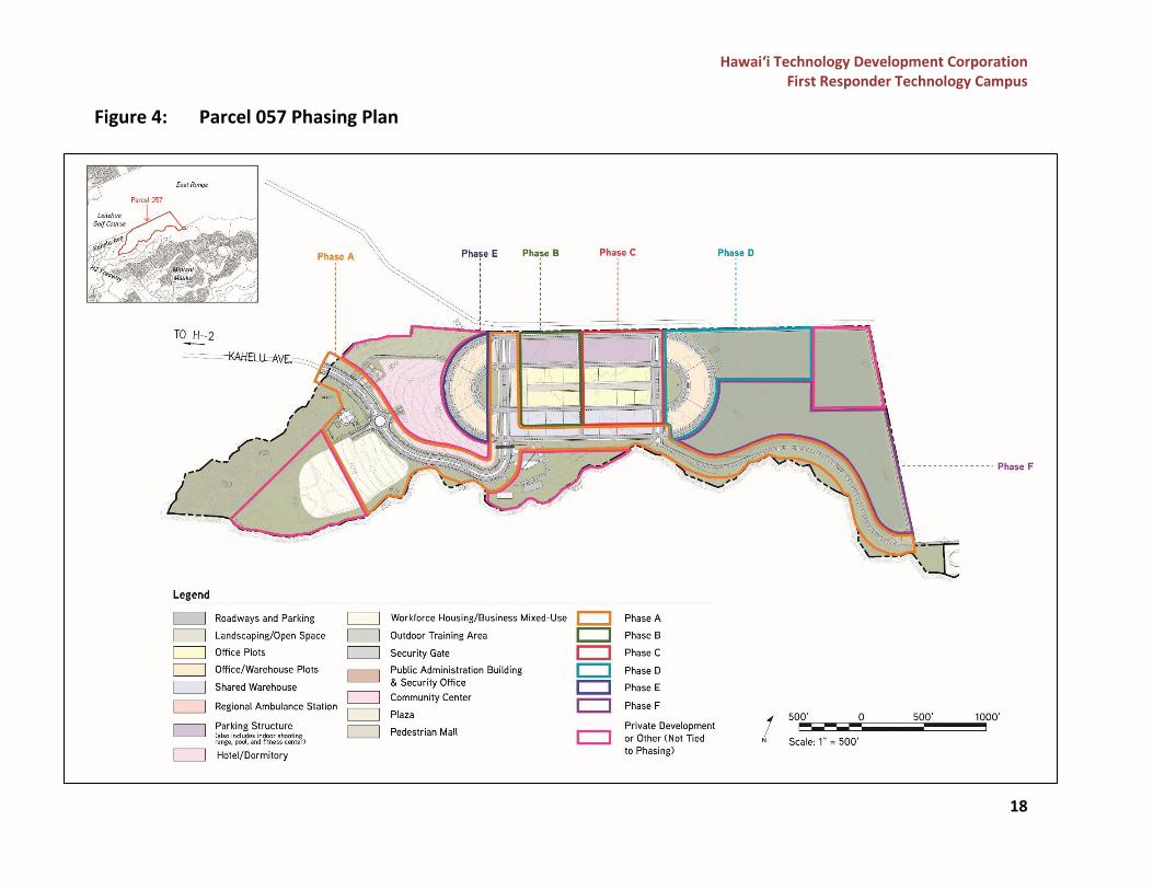
The construction of the FRTC is expected to commence upon issuance of the required State and County permits and approvals. Construction may start in 2023 pending all entitlements and permits are secured, and full buildout of the campus may be completed by 2038. The campus is proposed to be developed in six (6) phases spanning the next 15 years. A plan showing the preliminary phases and locations is provided in Figures 4 and 5. Phase A (2023-2025) would include the construction and grading for the extension of Kahelu Avenue through Parcel 057 up to Parcel 039, and the area for the water tank, well, appurtenant facilities and construction staging area. A new roadway will be constructed that will run north from a proposed roundabout into the FRTC. Drainage and utilities (sewer, water, electrical, communications, and cybersecurity) will be constructed in the roadways in preparation for the full campus buildout in the future. Phase B (2025-2027) would include the construction of the public administration building, security office, security gates, responder plaza, office buildings, warehouse buildings, and roadways. A portion of the parking structure will also be built, and will include the meeting rooms, helipad, indoor training area, and cafeteria. The construction in this phase would also
Hawai‘i Technology Development Corporation First Responder Technology Campus
15
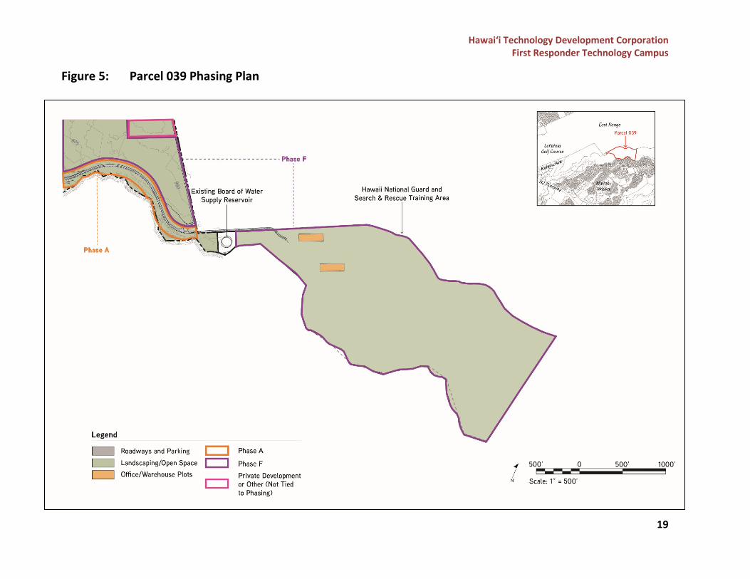
include grading, drainage, and utilities in the roadways to serve the new construction in this phase. Phase C (2028-2030) would include the completion of the parking structure and construction of office and warehouse buildings. Grading, drainage, and utilities would also be included to serve the new development in this phase. Phase D (2031-2033) would include the construction of additional office and warehouse buildings, classrooms, storage, meeting rooms, outdoor training areas, and the EVOC track. Grading, drainage, and utilities would also be included to serve the new development in this phase. Phase E (2034-2036) would complete the construction of office and warehouse buildings, classrooms, storage, and meeting rooms, and will include the construction of the exit gate and roadway. Grading, drainage, and utilities would also be included to serve the new development in this phase. Phase F (2037-2038) would include the development of Parcel 039 and complete the construction of the outdoor training areas, including the physical training towers, obstacle courses, and simulation training areas.
Hawai‘i Technology Development Corporation First Responder Technology Campus
16
Figure 2: Site Plan of Parcel 057
Hawai‘i Technology Development Corporation First Responder Technology Campus
17
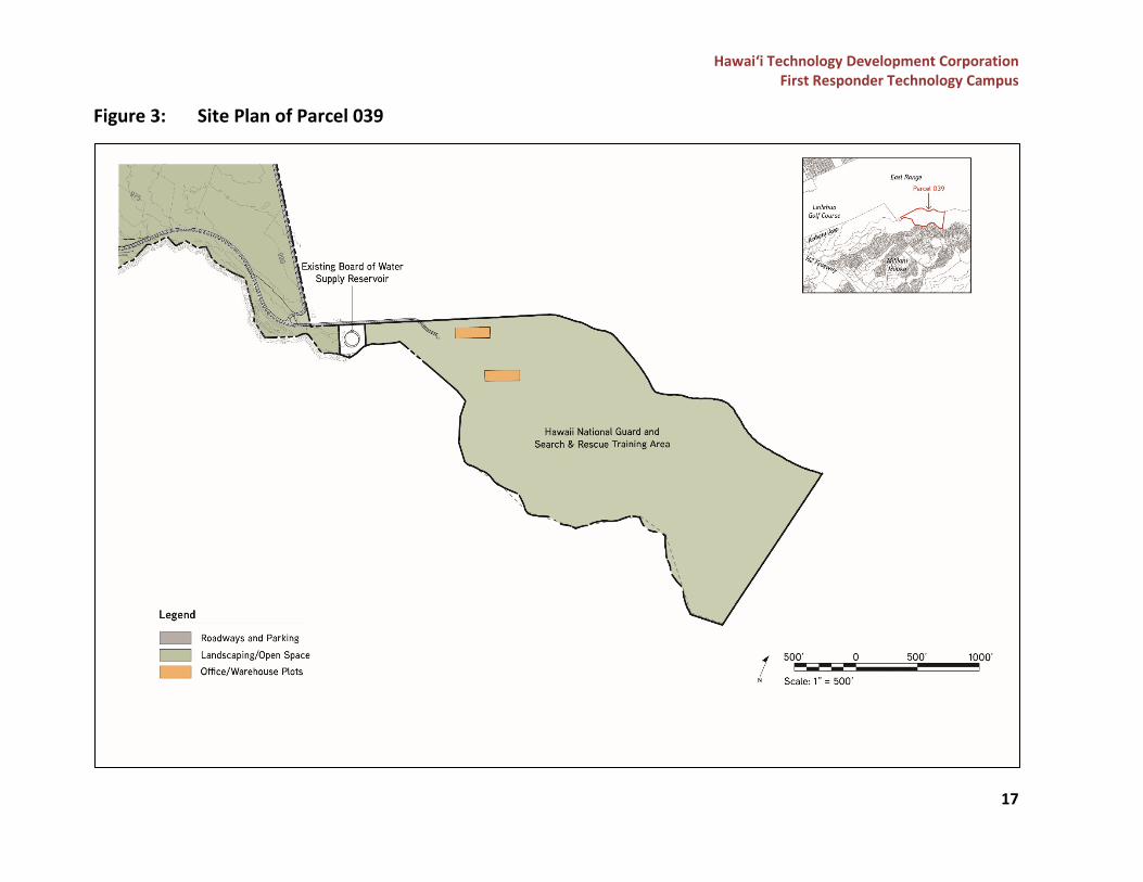
Figure 3: Site Plan of Parcel 039
Hawai‘i Technology Development Corporation First Responder Technology Campus
18
Figure 4: Parcel 057 Phasing Plan
Hawai‘i Technology Development Corporation First Responder Technology Campus
19
Figure 5: Parcel 039 Phasing Plan
Hawai‘i Technology Development Corporation First Responder Technology Campus
20
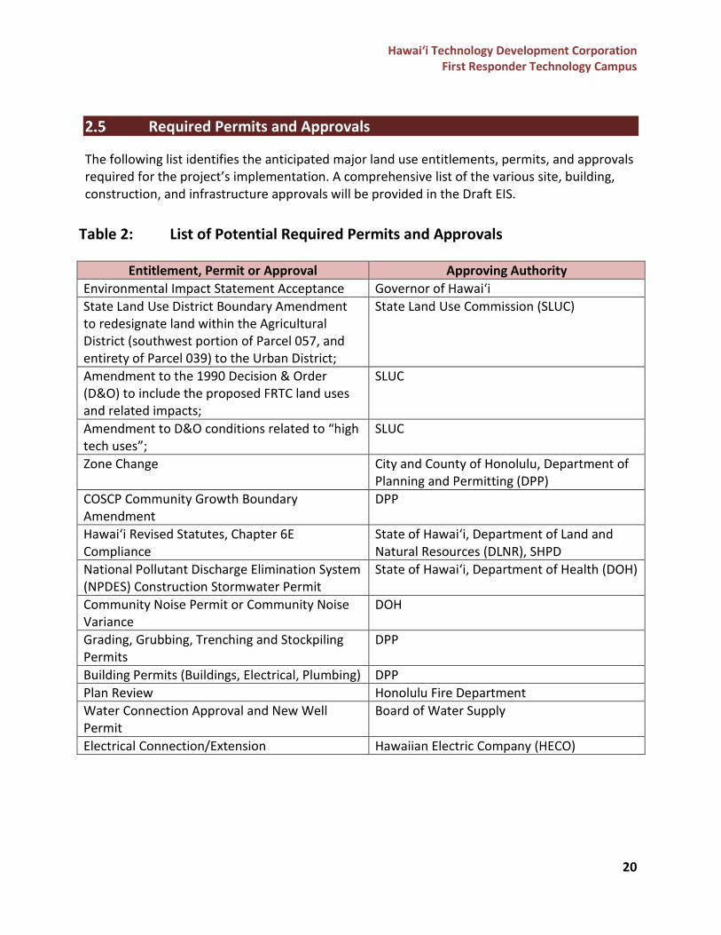
Required Permits and Approvals
The following list identifies the anticipated major land use entitlements, permits, and approvals required for the project’s implementation. A comprehensive list of the various site, building, construction, and infrastructure approvals will be provided in the Draft EIS.
Table 2: List of Potential Required Permits and Approvals
Entitlement, Permit or Approval Approving Authority Environmental Impact Statement Acceptance Governor of Hawai‘i State Land Use District Boundary Amendment to redesignate land within the Agricultural District (southwest portion of Parcel 057, and entirety of Parcel 039) to the Urban District;
State Land Use Commission (SLUC)
Amendment to the 1990 Decision & Order (D&O) to include the proposed FRTC land uses and related impacts;
SLUC
Amendment to D&O conditions related to “high tech uses”;
SLUC
Zone Change City and County of Honolulu, Department of Planning and Permitting (DPP)
COSCP Community Growth Boundary Amendment
DPP
Hawai‘i Revised Statutes, Chapter 6E Compliance
State of Hawai‘i, Department of Land and Natural Resources (DLNR), SHPD
National Pollutant Discharge Elimination System (NPDES) Construction Stormwater Permit
State of Hawai‘i, Department of Health (DOH)
Community Noise Permit or Community Noise Variance
DOH
Grading, Grubbing, Trenching and Stockpiling Permits
DPP
Building Permits (Buildings, Electrical, Plumbing) DPP Plan Review Honolulu Fire Department Water Connection Approval and New Well Permit
Board of Water Supply
Electrical Connection/Extension Hawaiian Electric Company (HECO)
Hawai‘i Technology Development Corporation First Responder Technology Campus
21
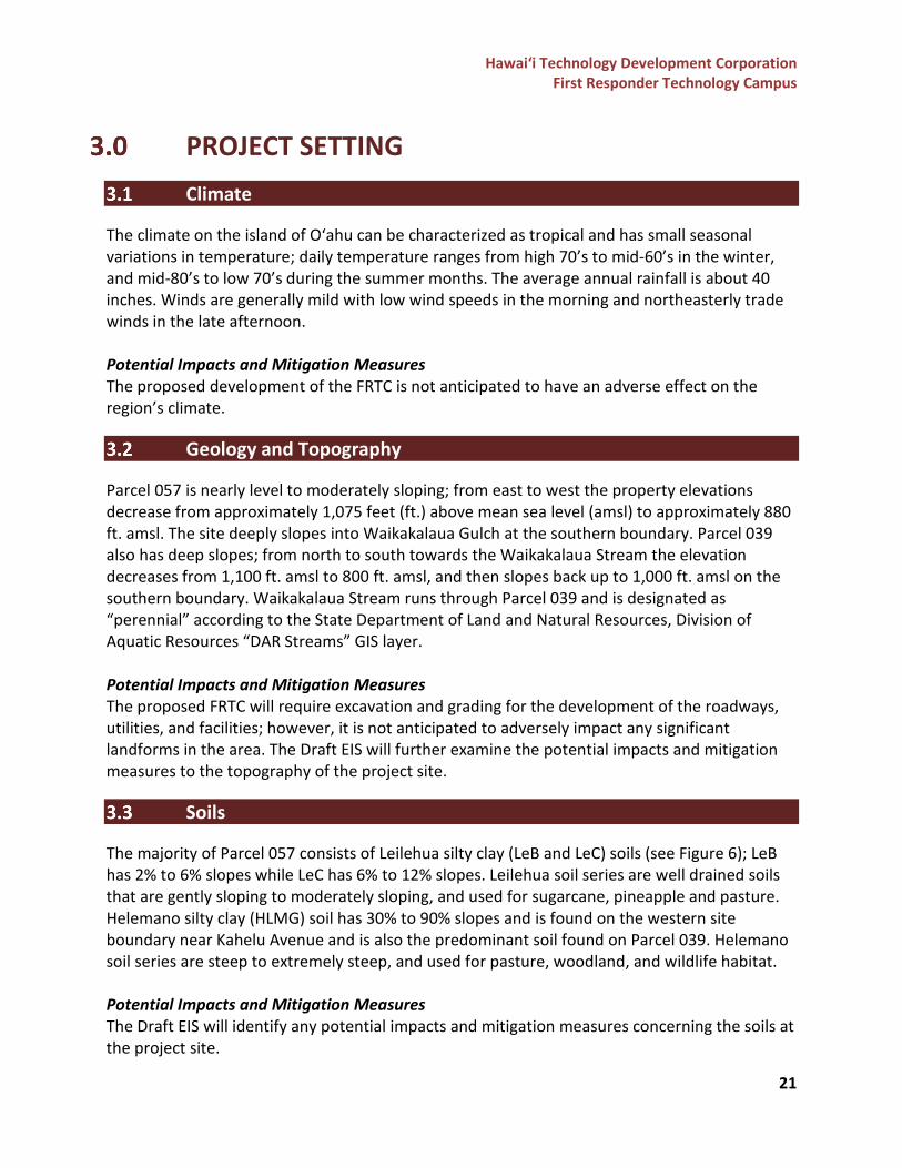
PROJECT SETTING Climate
The climate on the island of O‘ahu can be characterized as tropical and has small seasonal variations in temperature; daily temperature ranges from high 70’s to mid-60’s in the winter, and mid-80’s to low 70’s during the summer months. The average annual rainfall is about 40 inches. Winds are generally mild with low wind speeds in the morning and northeasterly trade winds in the late afternoon. Potential Impacts and Mitigation Measures The proposed development of the FRTC is not anticipated to have an adverse effect on the region’s climate.
Geology and Topography
Parcel 057 is nearly level to moderately sloping; from east to west the property elevations decrease from approximately 1,075 feet (ft.) above mean sea level (amsl) to approximately 880 ft. amsl. The site deeply slopes into Waikakalaua Gulch at the southern boundary. Parcel 039 also has deep slopes; from north to south towards the Waikakalaua Stream the elevation decreases from 1,100 ft. amsl to 800 ft. amsl, and then slopes back up to 1,000 ft. amsl on the southern boundary. Waikakalaua Stream runs through Parcel 039 and is designated as “perennial” according to the State Department of Land and Natural Resources, Division of Aquatic Resources “DAR Streams” GIS layer. Potential Impacts and Mitigation Measures The proposed FRTC will require excavation and grading for the development of the roadways, utilities, and facilities; however, it is not anticipated to adversely impact any significant landforms in the area. The Draft EIS will further examine the potential impacts and mitigation measures to the topography of the project site.
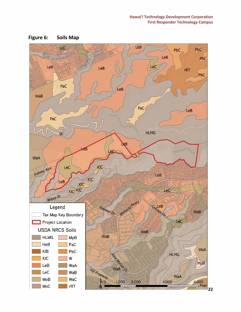
Soils
The majority of Parcel 057 consists of Leilehua silty clay (LeB and LeC) soils (see Figure 6); LeB has 2% to 6% slopes while LeC has 6% to 12% slopes. Leilehua soil series are well drained soils that are gently sloping to moderately sloping, and used for sugarcane, pineapple and pasture. Helemano silty clay (HLMG) soil has 30% to 90% slopes and is found on the western site boundary near Kahelu Avenue and is also the predominant soil found on Parcel 039. Helemano soil series are steep to extremely steep, and used for pasture, woodland, and wildlife habitat. Potential Impacts and Mitigation Measures The Draft EIS will identify any potential impacts and mitigation measures concerning the soils at the project site.
Hawai‘i Technology Development Corporation First Responder Technology Campus
22
Figure 6: Soils Map
Hawai‘i Technology Development Corporation First Responder Technology Campus
23
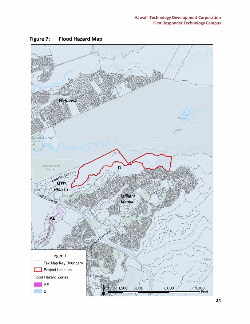
Natural Hazards
The site is within the Federal Emergency Management Agency’s (FEMA) Flood Zone D according to FEMA’s Flood Insurance Rate Map (see Figure 7). Flood Zone D corresponds to areas where there are possible but undetermined flood hazards and areas where no analysis of flood hazards has been conducted. The proposed site is outside of the tsunami evacuation zone and the sea level rise exposure area, as it is located 10 miles away from the nearest coastline. Potential Impacts and Mitigation Measures The proposed FRTC is not anticipated to be adversely affected by flood hazards, tsunamis, sea level rise, and/or coastal hazards.
Ground, Surface, and Marine Waters
The project site is located within the Pearl Harbor Sector, Waipahu-Waiawa System and the Central Aquifer Sector, Wahiawā System. The Pearl Harbor and Central Aquifers are part of the major groundwater areas defined by the State Commission on Water Resource Management (CWRM) based on geologic and hydrologic differences. According to the U.S. Fish and Wildlife Service (USFWS), National Wetlands Inventory (NWI) dataset, the Waikakalaua Stream that runs through Parcel 039 is classified as a riverine system, upper perennial subsystem, unconsolidated bottom class, and permanently flooded water regime (R3UBH). This classification includes wetlands and deep-water habitats where some water covers the substrate throughout the year. Within proximity to the project site is Ki‘iki‘i Stream, which connects to Wahiawā Reservoir. The project site is not within proximity to any marine or coastal waters. Potential Impacts and Mitigation Measures The Draft EIS will examine the potential impacts and mitigation measures to the aquifers and the Waikakalaua Stream.
Hawai‘i Technology Development Corporation First Responder Technology Campus
24
Figure 7: Flood Hazard Map
Hawai‘i Technology Development Corporation First Responder Technology Campus
25
Flora and Fauna
A biological survey report is being conducted for this project and will be included in the Draft EIS. The report will include the identification of flora and fauna species and habitats in the project area, including the identification of any Federally or State-listed threatened or endangered species. Potential Impacts and Mitigation Measures The biological survey report will include any potential impacts and mitigation measures to flora and fauna species and habitats in the project area, which will be included in the Draft EIS.
Air Quality and Water Quality
Air quality and water quality assessment reports are being prepared for this project and will be included in the Draft EIS. The report will analyze the proposed construction and operational impacts of the FRTC to the air and water quality of the surrounding area. Potential Impacts and Mitigation Measures The air and water quality assessment reports will include any potential impacts and mitigation measures to the air and water quality of the surrounding area, which will be included in the Draft EIS.
Noise
A noise assessment report is being prepared for this project and will be included in the Draft EIS. The report will analyze the proposed construction and operational impacts of the FRTC to the existing noise conditions in the surrounding area. Potential Impacts and Mitigation Measures The proposed facilities at the FRTC will increase the noise levels within the area due to the operations and functions at the campus. There will also be temporary impacts to the noise quality from construction related activities. The noise assessment report will further examine the potential impacts and mitigation measures anticipated from the FRTC from construction and post-construction/operational activities, which will be included in the Draft EIS.
Utilities, Infrastructure and Traffic
The project site is currently undeveloped and does not have any existing utilities or infrastructure servicing the project site. HECO has several easements running through Parcel 057 for electrical transmission lines. Two 25-ft. wide easements run from north to south for HECO’s high-voltage electrical transmission lines; one is within the western portion and the other is in the eastern portion of Parcel 057. A 15-ft. wide easement runs completely across Parcel 057 from east to west and contains an electrical line that runs from Kahelu Avenue up until it intersects with the electrical line within the north-south 25-ft. wide easement on the
Hawai‘i Technology Development Corporation First Responder Technology Campus
26
western portion of the site. A 10-ft. wide easement for utility purposes runs along the southern property line of the parcel, starting from the 25-ft. wide north-south easement on the western portion of the site and ending at the south-east property line. In addition, the BWS also has several easements that run through Parcel 057 to access the water reservoir located between Parcel 057 and 039, which provides service to Mililani Tech Park Phase 1. Potential Impacts and Mitigation Measures The Draft EIS will further examine the features of the built environment proposed for the project, such as anticipated infrastructure demands; impacts to roadways and surrounding traffic; water and wastewater; stormwater runoff and drainage; and power, cable, and telecommunications systems. The Draft EIS will also include potential impacts to the surrounding environment and mitigation measures.
Socio-Economic Characteristics
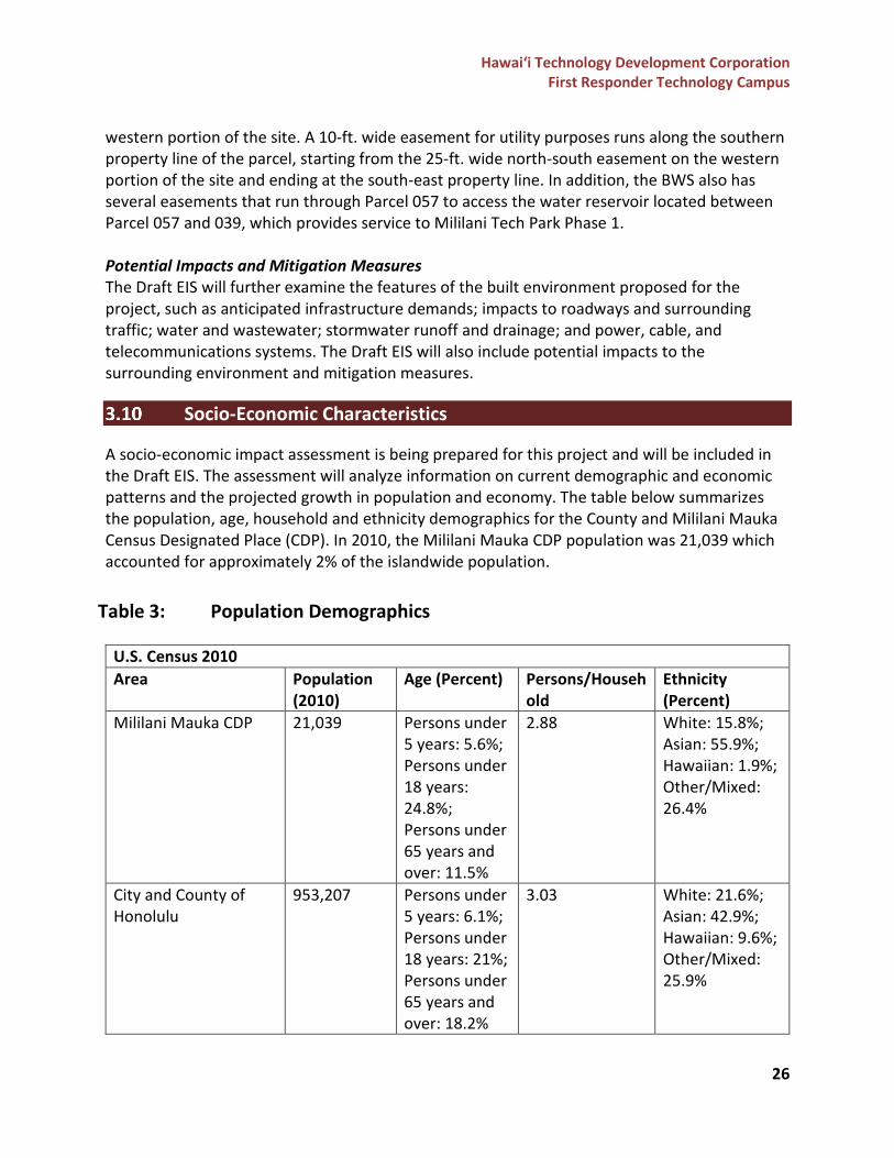
A socio-economic impact assessment is being prepared for this project and will be included in the Draft EIS. The assessment will analyze information on current demographic and economic patterns and the projected growth in population and economy. The table below summarizes the population, age, household and ethnicity demographics for the County and Mililani Mauka Census Designated Place (CDP). In 2010, the Mililani Mauka CDP population was 21,039 which accounted for approximately 2% of the islandwide population.
Table 3: Population Demographics
U.S. Census 2010 Area Population
(2010) Age (Percent) Persons/Househ
old Ethnicity (Percent)
Mililani Mauka CDP 21,039 Persons under 5 years: 5.6%; Persons under 18 years: 24.8%; Persons under 65 years and over: 11.5%
2.88 White: 15.8%; Asian: 55.9%; Hawaiian: 1.9%; Other/Mixed: 26.4%
City and County of Honolulu
953,207 Persons under 5 years: 6.1%; Persons under 18 years: 21%; Persons under 65 years and over: 18.2%
3.03 White: 21.6%; Asian: 42.9%; Hawaiian: 9.6%; Other/Mixed: 25.9%
Hawai‘i Technology Development Corporation First Responder Technology Campus
27
Potential Impacts and Mitigation Measures The socio-economic impact assessment will assess the impacts of the project to the local economy through the construction expenditures and generation of jobs. It will also assess potential impacts to the current demographic and projected growth in population of the surrounding region.
Public Facilities and Services
Educational Facilities The State of Hawai‘i, Department of Education (DOE) operates the State’s public school system. The proposed project is within the DOE’s Central Region, Leilehua-Mililani-Waialua Complex, and is adjacent to the Pearl City-Waipahu Complex. The following DOE schools are within proximity to the project site:
• Kipapa Elementary School • Mililani Mauka Elementary School • Mililani Middle School • Mililani ‘Ike Elementary School • Wheeler Elementary School • Wheeler Middle School • Wahiawā Middle School • Ka‘ala Elementary School
Recreational Facilities The recreational facilities and public parks within proximity to the project site are run by the U.S. Army Garrison, Wheeler Army Airfield, DLNR, or the City and County of Honolulu Department of Parks and Recreation (DPR). The following parks and recreational facilities are within proximity to the project site:
• Mililani Dog Park • Mililani Mauka District Park • Ku‘ulako Park • Mililani Mauka Community Park • Leilehua Golf Course • Wheeler Dog Park • Wahiawā Freshwater State Recreation Area • Ka‘ala Neighborhood Park
Police The proposed project is in the Honolulu Police Department’s District 2 Mililani/Wahiawā/North Shore District, Beat 256. The only police station within proximity to the project site is the Wahiawā Police Station, which is an approximate 3-mile drive.
Hawai‘i Technology Development Corporation First Responder Technology Campus
28
Fire The project site is located within proximity to the Honolulu Fire Department’s Fire Station 41 Mililani Mauka and Fire Station 16 Wahiawā. Emergency Medical Services The Wahiawā General Hospital is the closest hospital to the project site. Wahiawā General Hospital is a community-owned, non-profit hospital that serves Wahiawā, Central O‘ahu, and the North Shore communities on O‘ahu. Solid Waste Management The City and County of Honolulu Department of Environmental Services, Refuse Division is the municipal agency responsible for the collection, transport, and disposal of O‘ahu’ s solid waste. Solid waste services include drop-off facilities, curbside collection, and recycling. Most of the residential and commercial solid waste is disposed of at H-POWER, the City’s waste-to-energy plant, located at Campbell Industrial Park, or at one of two landfills: Waimānalo Gulch Sanitary Landfill or the PVT Landfill, both located on the Wai‘anae Coast. Potential Impacts and Mitigation Measures The FRTC is not anticipated to adversely impact educational facilities or recreational facilities in the area. First responder agencies’ facilities will be relocated to the FRTC and will be designed to meet the operational and training needs of the agencies. This is anticipated to have a positive impact for first responder agencies’ operations and processes, which will also positively impact the surrounding communities.
Cultural Practices and Resources
A cultural impact assessment is being prepared for this project and will be included in the Draft EIS. This assessment will include reviews of historical documentation for preliminary identification of potential traditional cultural properties, features, resources, beliefs, and practices within or near the project area. It will identify traditional land use activities, cultural resources, and associative practices and beliefs; and include information obtained from discussions with identified knowledgeable individuals regarding historic and traditional practices that are site-specific and inclusive of the ahupua‘a involved (Waipio and Waikele). Potential Impacts and Mitigation Measures The Draft EIS will further examine the potential impacts that the project will have on cultural properties, features, resources, beliefs, and practices within or near the project area. Minimization and mitigation measures will also be identified, as applicable.
Historic and Archaeological Resources
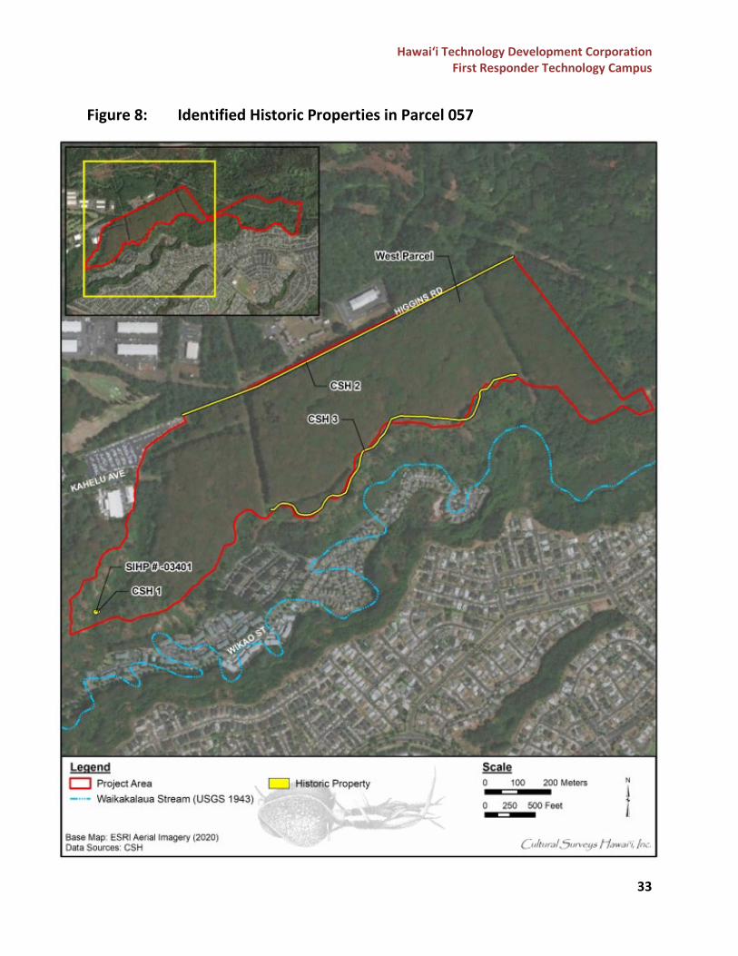
In July 2021, CSH prepared a Draft Archaeological Literature Review and Field Inspection Report for the FRTC. CSH conducted a 100%-coverage pedestrian inspection of Parcel 057, and a brief pedestrian inspection of Parcel 039, for the purposes of cultural resource identification and
Hawai‘i Technology Development Corporation First Responder Technology Campus
29
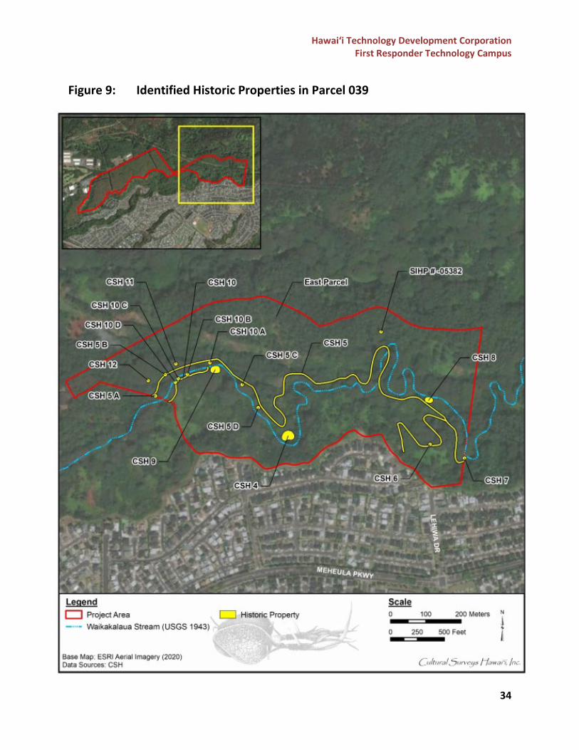
documentation. In addition, CSH conducted background research including a review of previous archaeological studies on file at the SHPD office, and reviews of documents at the Hawai‘i State libraries, University of Hawai‘i libraries, Hawai‘i State Archives, Bishop Museum Archives, and historic maps at the State Department of Accounting and General Services (DAGS) office. According to CSH’s report, the project site is located within the Waipio and Waikele Ahupua‘a in the moku (traditional district) of ‘Ewa. It is believed that the mauka (inland) portions of the Waipio Ahupua‘a were not likely a location of permanent Native Hawaiian settlement or traditional-style irrigated cultivation (e.g., taro), but were most likely a location where non-irrigated forest clearings of sweet potatoes and other crops were grown. In the late pre-contact and early post-contact times, Waipio is associated with intra- and inter-island struggles for control over O‘ahu and with the Hawaiian Kingdom’s entrance into the world market economy by means of the sandalwood trade. In the middle of the 19th century, Native Hawaiian activity and habitation were clustered in the makai lowlands and fishponds near the coast. In contrast, the mauka regions were often described as virtually uninhabited. By the early 1900s, lands in the mauka portions of Waikele and Waipio Ahupua‘a were being acquired for pineapple cultivation. Parcel 057 was under pineapple cultivation and the southern border of the parcel was used as “grazing land”. From 1929 to 1953, historic U.S. Geological Survey (USGS) maps indicate the rapid agricultural and military development that occurred within the area, including new roadways for military use, plantation camps, and water tanks. During the late 20th century to the early 21st century, growth in the area focused on residential development, namely the development of the master-planned community of Mililani. The construction of the H-2 Freeway began in 1973, and by 1990 construction began for the Mililani Mauka residential area. No major developments have occurred within the project area since its abandonment from the plantation and various agricultural uses. Based on the research conducted by CSH, eight archaeological studies were done within the vicinity of the project area. The earliest recorded archaeological study was done in 1933 by J. Gilbert McAllister, who identified one site, Site 204 Oahunui Stone, whose approximate location has been reported to be within or near the northeast corner of Parcel 057. The Oahunui Stone is described as a stone whose outline is said to resemble that of O‘ahu, and was a site formerly visited by Hawaiians. Based on background research, it is believed that traditional Hawaiian settlement was more concentrated near the coastal areas where marine sources were readily available. The Waikakalaua Gulch may have supported inland settlement by providing forest resources for traditional gathering. The reported location of the Oahunui Stone in or near the project area, and the associated legends surrounding the stone, suggest that a chiefly settlement may have been in the near vicinity. However, the lack of Land Commission Award claims in the immediate
Hawai‘i Technology Development Corporation First Responder Technology Campus
30
vicinity of the project area suggest that permanent habitation of the area may not have been common through the post-contact era. Prior to its plantation use, it is also believed that the study area may have contained cultural resources related to gardening activities, wetland agricultural development, and habitation remnants. The intensity of land modification from decades of plantation agriculture is likely to have removed much of the evidence of traditional land uses. It is therefore anticipated that remnants of historic plantation infrastructure and features are likely to exist, as well as military-related structures. No traditional historic properties are anticipated in Parcel 057, although the likelihood of plantation-era infrastructure remnants is high. From June 7 to June 11, 2021, CSH conducted a field survey of the project area. CSH identified a total of fourteen historic properties: four within Parcel 057 and ten within Parcel 039. During the field inspection, an alignment of basalt boulders and cobbles were observed, which were believed to be a portion of the features SIHP # 50-80-09-3401 and 50-80-09-4843 that were identified by Hommon and Ahlo in 1983 and by Kennedy in 1985. Later studies of the area were not able to identify the terrace, thus suggesting that the feature observed by CSH during the field inspection was likely the result of the eroding cliff face. Both Hommon and Ahlo and Kennedy noted that the historic property does not warrant any further preservation work. A stacked basalt mound/ahu (CSH 1) was found near the southwest corner of Parcel 057. Two earthen ditches (CSH 2 and 3) were found in the northern and southern boundary of Parcel 057, and both are understood to be the remnants of a field channel for the former pineapple fields. During the survey of Parcel 039, CSH encountered SIHP #50-80-09-5382, which consists of a military related concrete tunnel on the north slope of Waikakalaua Gulch originally observed by Robins and Spear in 2002. During the inspection CSH confirmed the observations made by Robins and Spear. Robins and Spear had proposed that SIHP #50-80-09-5382 is eligible for listing in the National Register of Historic Places under Criteria C and D. CSH encountered a historic habitation complex (designated as CSH 4) located approximately 11 meters (m) north of Waikakalaua Stream. CSH 4 contains eight sub-features consisting of retaining walls, small stair alignments, and concrete posts. Other potential historic properties identified in this parcel include a historic road network (CSH 5) that primarily extends along the banks of Waikakalaua Stream. Sub-features of this road include wooden gate posts and intermittent spans of stacked basalt retaining walls/alignments along the edges. Remnants of plantation-era infrastructure were also observed along the road, including a concrete structural remnant (CSH 6), remnant water pumping station (CSH 7), and water control complex (CSH 8). South of the Waikakalaua Stream is the site of a historic habitation complex consisting of basalt retaining walls, basalt and concrete staircases, and concrete walkways (CSH 9). The Waikakalaua Ditch Complex (CSH 10) contained features such as a dam, retaining walls, and sluice gates with foot bridges. The following table documents the fourteen historic properties identified during the field inspection conducted by CSH. Two of the properties identified are believed to be portions of
Hawai‘i Technology Development Corporation First Responder Technology Campus
31
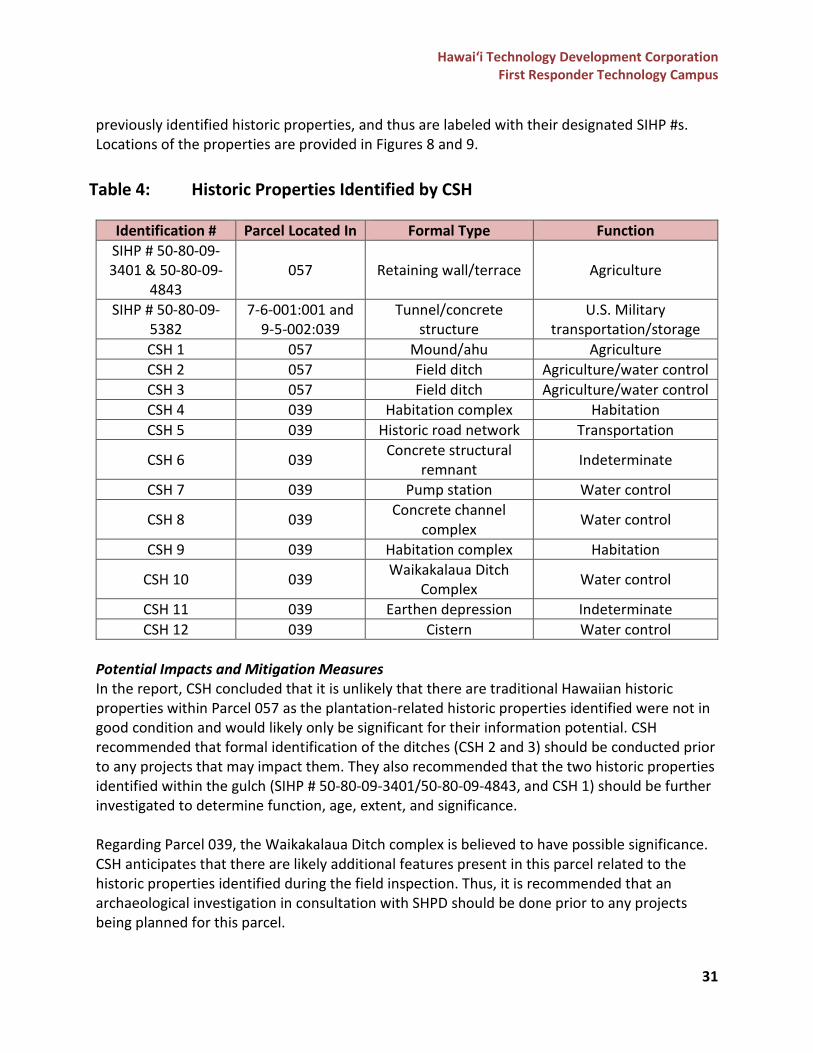
previously identified historic properties, and thus are labeled with their designated SIHP #s. Locations of the properties are provided in Figures 8 and 9.
Table 4: Historic Properties Identified by CSH
Identification # Parcel Located In Formal Type Function SIHP # 50-80-09-3401 & 50-80-09-
4843 057 Retaining wall/terrace Agriculture
SIHP # 50-80-09-5382
7-6-001:001 and 9-5-002:039
Tunnel/concrete structure
U.S. Military transportation/storage
CSH 1 057 Mound/ahu Agriculture CSH 2 057 Field ditch Agriculture/water control CSH 3 057 Field ditch Agriculture/water control CSH 4 039 Habitation complex Habitation CSH 5 039 Historic road network Transportation
CSH 6 039 Concrete structural remnant Indeterminate
CSH 7 039 Pump station Water control
CSH 8 039 Concrete channel complex Water control
CSH 9 039 Habitation complex Habitation
CSH 10 039 Waikakalaua Ditch Complex Water control
CSH 11 039 Earthen depression Indeterminate CSH 12 039 Cistern Water control
Potential Impacts and Mitigation Measures In the report, CSH concluded that it is unlikely that there are traditional Hawaiian historic properties within Parcel 057 as the plantation-related historic properties identified were not in good condition and would likely only be significant for their information potential. CSH recommended that formal identification of the ditches (CSH 2 and 3) should be conducted prior to any projects that may impact them. They also recommended that the two historic properties identified within the gulch (SIHP # 50-80-09-3401/50-80-09-4843, and CSH 1) should be further investigated to determine function, age, extent, and significance. Regarding Parcel 039, the Waikakalaua Ditch complex is believed to have possible significance. CSH anticipates that there are likely additional features present in this parcel related to the historic properties identified during the field inspection. Thus, it is recommended that an archaeological investigation in consultation with SHPD should be done prior to any projects being planned for this parcel.
Hawai‘i Technology Development Corporation First Responder Technology Campus
32
As part of the Draft EIS process, further consultation with SHPD will be conducted to identify the necessary processes to minimize or avoid any potential impacts, and if needed, determine the necessary mitigation commitments to minimize the impacts to cultural or historic resources within the project area. Consultation with the O‘ahu Island Burial Council and the cultural/lineal descendants of the area will also be conducted during the Draft EIS process. CSH will be preparing a Final Archaeological Literature Review and Field Inspection Report that will include potential impacts, mitigation measures, and recommendations provided through consultation with SHPD, the O‘ahu Island Burial Council, and the cultural/lineal descendants of the area, which will be included in the Draft EIS.
Hawai‘i Technology Development Corporation First Responder Technology Campus
33
Figure 8: Identified Historic Properties in Parcel 057
Hawai‘i Technology Development Corporation First Responder Technology Campus
34
Figure 9: Identified Historic Properties in Parcel 039
Hawai‘i Technology Development Corporation First Responder Technology Campus
35
Land Use Plans and Policies
Hawai‘i State Plan
The Hawai‘i State Plan was set forth by the Hawai‘i State Planning Act, which was signed into law in 1978 and codified under HRS Chapter 226. The plan is a long-range comprehensive plan that identifies goals, objectives, policies, and priorities for the State. The plan is divided into three parts, in which the first part identifies the overall theme, goals, objectives, and policies of the State. The listing below identifies the objectives and policies that are met by the FRTC. The Draft EIS will include a discussion on how the objectives and policies of the plan are met by the project.
HRS Chapter 226 Hawai‘i State Planning Act Applicability to Project Part I. Overall Theme, Goals, Objectives, and Policies
§226-5 Objective and policies for population Not applicable §226-6 Objectives and policies for the economy--in general Not applicable §226-7 Objectives and policies for the economy-- agriculture Not applicable §226-8 Objective and policies for the economy--visitor industry Applicable §226-9 Objective and policies for the economy--federal expenditures Applicable §226-10 Objective and policies for the economy--potential growth and innovative activities Applicable
§226-10.5 Objectives and policies for the economy--information industry Not applicable §226-11 Objectives and policies for the physical environment--land-based, shoreline, and marine resources Not applicable
§226-12 Objective and policies for the physical environment--scenic, natural beauty, and historic resources Not applicable
§226-13 Objectives and policies for the physical environment--land, air, and water quality Not applicable
§226-14 Objective and policies for facility systems--in general Not applicable §226-15 Objectives and policies for facility systems--solid and liquid wastes Not applicable §226-16 Objective and policies for facility systems--water Not applicable §226-17 Objectives and policies for facility systems--transportation Not applicable §226-18 Objectives and policies for facility systems--energy Not applicable §226-18.5 Objectives and policies for facility systems--telecommunications Not applicable §226-19 Objectives and policies for socio-cultural advancement--housing Applicable §226-20 Objectives and policies for socio-cultural advancement--health Not applicable §226-21 Objective and policies for socio-cultural advancement--education Not applicable §226-22 Objective and policies for socio-cultural advancement--social services Not applicable §226-23 Objective and policies for socio-cultural advancement--leisure Not applicable §226-24 Objective and policies for socio-cultural advancement--individual rights and personal well-being Not applicable
§226-25 Objective and policies for socio-cultural advancement--culture Not applicable §226-26 Objective and policies for socio-cultural advancement--public safety Applicable §226-27 Objective and policies for socio-cultural advancement--government Applicable Part III. Priority Guidelines
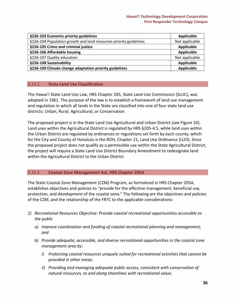
Hawai‘i Technology Development Corporation First Responder Technology Campus
36
§226-103 Economic priority guidelines Applicable §226-104 Population growth and land resources priority guidelines Not applicable §226-105 Crime and criminal justice Applicable §226-106 Affordable housing Applicable §226-107 Quality education Not applicable §226-108 Sustainability Applicable §226-109 Climate change adaptation priority guidelines Applicable
State Land Use Classification
The Hawai‘i State Land Use Law, HRS Chapter 205, State Land Use Commission (SLUC), was adopted in 1961. The purpose of the law is to establish a framework of land use management and regulation in which all lands in the State are classified into one of four state land use districts: Urban, Rural, Agricultural, or Conservation. The proposed project is in the State Land Use Agricultural and Urban District (see Figure 10). Land uses within the Agricultural District is regulated by HRS §205-4.5, while land uses within the Urban District are regulated by ordinances or regulations set forth by each county, which for the City and County of Honolulu is the ROH, Chapter 21, Land Use Ordinance (LUO). Since the proposed project does not qualify as a permissible use within the State Agricultural District, the project will require a State Land Use District Boundary Amendment to redesignate land within the Agricultural District to the Urban District.
Coastal Zone Management Act, HRS Chapter 205A
The State Coastal Zone Management (CZM) Program, as formalized in HRS Chapter 205A, establishes objectives and policies to “provide for the effective management, beneficial use, protection, and development of the coastal zone.” The following are the objectives and policies of the CZM, and the relationship of the FRTC to the applicable considerations:
1) Recreational Resources Objective: Provide coastal recreational opportunities accessible to the public
a) Improve coordination and funding of coastal recreational planning and management; and
b) Provide adequate, accessible, and diverse recreational opportunities in the coastal zone management area by:
i) Protecting coastal resources uniquely suited for recreational activities that cannot be provided in other areas;
ii) Providing and managing adequate public access, consistent with conservation of natural resources, to and along shorelines with recreational value;
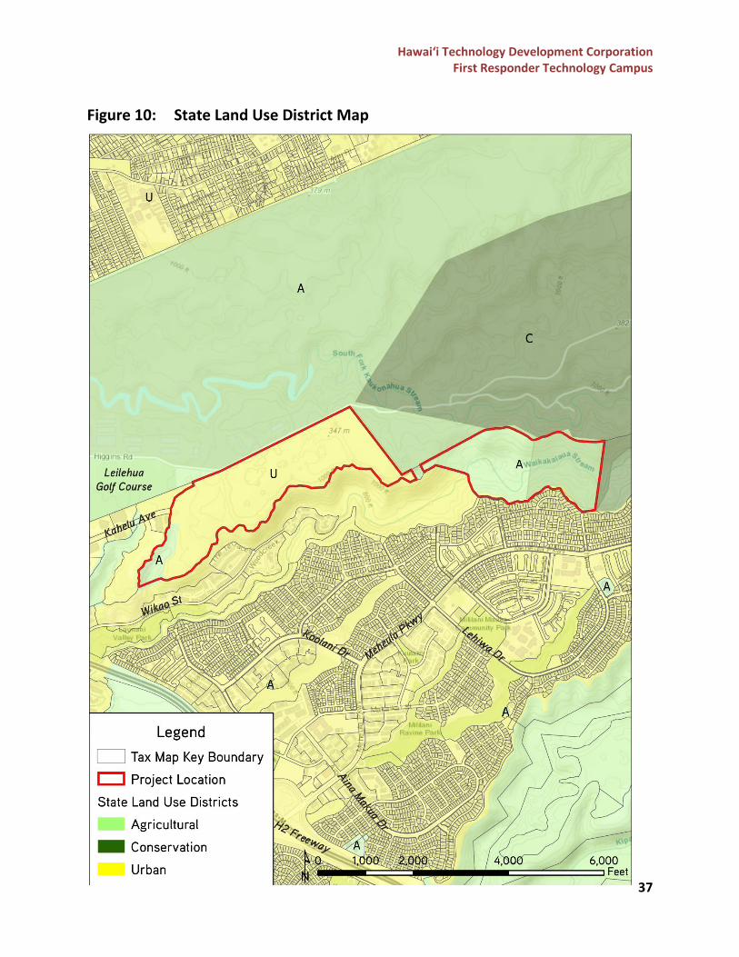
Hawai‘i Technology Development Corporation First Responder Technology Campus
37
Figure 10: State Land Use District Map
Hawai‘i Technology Development Corporation First Responder Technology Campus
38
iii) Providing an adequate supply of shoreline parks and other recreational facilities suitable for public recreation;
iv) Ensuring public recreational uses of county, state, and federally owned or controlled shoreline lands and waters having recreational value consistent with public safety standards and conservation of natural resources;
v) Adopting water quality standards and regulating point and nonpoint sources of pollution to protect, and where feasible, restore the recreational value of coastal waters;
vi) Developing new shoreline recreational opportunities, where appropriate, such as artificial lagoons, artificial beaches, and artificial reefs for surfing and fishing; and
vii) Encouraging reasonable dedication of shoreline areas with recreational value for public use as part of discretionary approvals or permits by the land use commission, board of land and natural resources, and county authorities; and crediting such dedication against the requirements of section 46-6.
Discussion: Access to the shoreline areas would remain unaffected by the proposed project as the project site is not located near the shoreline.
2) Historic Resources Objective: Protect, preserve, and, where desirable, restore those natural
and manmade historic and prehistoric resources in the coastal zone management area that are significant in Hawaiian and American history and culture. a) Identify and analyze significant archaeological resources b) Maximize information retention through preservation of remains and artifacts or salvage
operations; and c) Support state goals for protection, restoration, interpretation, and display of historic
resources
Discussion: The proposed project would not affect any natural or manmade historic and prehistoric resources in the coastal zone management area, as the project site is not located near the shoreline. In addition, as previously discussed in Section 3.13, a Draft Archaeological Literature Review and Field Inspection Report was prepared by CSH which documented the known archaeological and historical resources in the project area based on previous archaeological studies. CSH also conducted a 100% pedestrian survey of both Parcel 057 and Parcel 039, and the findings are documented in Section 3.13 and Table 3. As part of the Draft EIS process, further consultation with SHPD will be conducted to identify the necessary processes to minimize or avoid any potential impacts, and if needed, determine the necessary mitigation commitments to minimize the impacts to cultural or historic resources within the project area. Consultation with the O‘ahu Island Burial Council and the cultural/lineal descendants of the area will also be conducted during the Draft EIS process.
Hawai‘i Technology Development Corporation First Responder Technology Campus
39
3) Scenic and Open Space Resources Objective: Protect, preserve, and, where desirable, restore or improve the quality of coastal scenic and open space resources. a) Identify valued scenic resources in the coastal zone management area; b) Ensure that new developments are compatible with their visual environment by designing
and locating such developments to minimize the alteration of natural landforms and existing public views to and along the shoreline;
c) Preserve, maintain, and, where desirable, improve and restore shoreline open space and scenic resources; and
d) Encourage those developments that are not coastal dependent to locate in inland areas. Discussion: Coastal scenic and open space resources will not be impacted by the proposed project. The FRTC will be located on undeveloped land and will not impact any natural landforms in the area. 4) Coastal Ecosystems Objective: Protect valuable coastal ecosystems, including reefs, from
disruption and minimize adverse impacts on all coastal ecosystems. a) Exercise an overall conservation ethic, and practice stewardship in the protection, use, and
development of marine and coastal resources; b) Improve the technical basis for natural resource management; c) Preserve valuable coastal ecosystems, including reefs, of significant biological or economic
importance; d) Minimize disruption or degradation of coastal water ecosystems by effective regulation of
stream diversions, channelization, and similar land and water uses, recognizing competing water needs; and
e) Promote water quantity and quality planning and management practices that reflect the tolerance of fresh water and marine ecosystems and maintain and enhance water quality through the development and implementation of point and nonpoint source water pollution control measures.
Discussion: The project will not impact coastal ecosystems as it will be located inland and away from the coastline. 5) Economic Uses Objective: Provide public or private facilities and improvements important to
the State’s economy in suitable locations. a) Concentrate coastal dependent development in appropriate areas; b) Ensure that coastal dependent development such as harbors and ports, and coastal
related development such as visitor industry facilities and energy generating facilities, are located, designed, and constructed to minimize adverse social, visual, and environmental impacts in the coastal zone management area; and
c) Direct the location and expansion of coastal dependent developments to areas presently designated and used for such developments and permit reasonable long-term growth at such areas, and permit coastal dependent development outside of presently designated areas when:
Hawai‘i Technology Development Corporation First Responder Technology Campus
40
i) Use of presently designated locations is not feasible; ii) Adverse environmental effects are minimized; and iii) The development is important to the State's economy.
Discussion: The FRTC is not proposed to be near the coastal areas and would not affect coastal development necessary to the State’s economy. 6) Coastal Hazards Objective: Reduce hazard to life and property from tsunami, storm waves,
stream flooding, erosion, subsidence, and pollution. a) Develop and communicate adequate information about storm wave, tsunami, flood,
erosion, subsidence, and point and nonpoint source pollution hazards; b) Control development in areas subject to storm wave, tsunami, flood, erosion, hurricane,
wind, subsidence, and point and nonpoint source pollution hazards; c) Ensure that developments comply with requirements of the Federal Flood Insurance
Program; and d) Prevent coastal flooding from inland projects.
Discussion: The development of the FRTC would support this objective, as it would locate existing first responder agencies’ facilities away from areas that are within the tsunami, storm wave, and flood inundation zones. A majority of the first responder agencies’ facilities are currently located in areas that are vulnerable to coastal hazards, including sea-level rise impacts. The FRTC is in Central O‘ahu approximately 10-miles from the nearest shoreline and is outside the tsunami inundation zone and the 3.2-ft. sea-level rise exposure area. 7) Managing Development Objective: Improve the development review process, communication,
and public participation in the management of coastal resources and hazards. a) Use, implement, and enforce existing law effectively to the maximum extent possible in
managing present and future coastal zone development; b) Facilitate timely processing of applications for development permits and resolve
overlapping or conflicting permit requirements; and c) Communicate the potential short and long-term impacts of proposed significant coastal
developments early in their life cycle and in terms understandable to the public to facilitate public participation in the planning and review process.
Discussion: While the FRTC will not be located near any coastal resources, and thus will not be prone to any coastal hazards, the project will still conduct an extensive public outreach process to ensure that Federal, State, and County agencies, elected officials, nearby landowners, community groups and organizations, and the community are aware of the project and are able to provide their feedback. All public outreach and consultation efforts will be documented in the Draft EIS. 8) Public Participation Objective: Stimulate public awareness, education, and participation in
coastal management.
Hawai‘i Technology Development Corporation First Responder Technology Campus
41
a) Promote public involvement in coastal zone management processes; b) Disseminate information on coastal management issues by means of educational
materials, published reports, staff contact, and public workshops for persons and organizations concerned with coastal issues, developments, and government activities; and
c) Organize workshops, policy dialogues, and site-specific mediations to respond to coastal issues and conflicts.
Discussion: As mentioned in the previous discussion, although the project site is not located near any coastal resources and will not be subject to coastal management issues, an extensive public outreach effort will be made to ensure that project information is disseminated and that the feedback from the community is documented and addressed throughout the project process. 9) Beach Protection Objective: Protect beaches for public use and recreation.
a) Locate new structures inland from the shoreline setback to conserve open space, minimize interference with natural shoreline processes, and minimize loss of improvements due to erosion;
b) Prohibit construction of private erosion-protection structures seaward of the shoreline, except when they result in improved aesthetic and engineering solutions to erosion at the sites and do not interfere with existing recreational and waterline activities; and
c) Minimize the construction of public erosion-protection structures seaward of the shoreline.
Discussion: The FRTC is not proposed to be located adjacent to the coast; therefore, it will not have any impact on shoreline activities and will not adversely impact any beaches. 10) Marine Resources Objective: Promote the protection, use, and development of marine and
coastal resources to assure their sustainability. a) Ensure that the use and development of marine and coastal resources are ecologically and
environmentally sound and economically beneficial; b) Coordinate the management of marine and coastal resources and activities to improve
effectiveness and efficiency; c) Assert and articulate the interests of the State as a partner with federal agencies in the
sound management of ocean resources within the United States exclusive economic zone; d) Promote research, study, and understanding of ocean processes, marine life, and other
ocean resources in order to acquire and inventory information necessary to understand how ocean development activities relate to and impact upon ocean and coastal resources; and
e) Encourage research and development of new, innovative technologies for exploring, using, or protecting marine and coastal resources. [L 1977, c 188, pt of §3; am L 1993, c 258, §1; am L 1994, c 3, §1; am L 1995, c 104, §5; am L 2001, c 169, §3]
Hawai‘i Technology Development Corporation First Responder Technology Campus
42
Discussion: The development of the FRTC would not adversely impact ocean resources and would not affect marine and coastal resources as it is not proposed to be located adjacent to or in the vicinity of these resources.
Hawai‘i 2050 Sustainability Plan
The Hawai‘i 2050 Sustainability Plan serves as the State’s sustainability and climate strategic action plan that delineates five goals toward a sustainable Hawai‘i, accompanied by strategic actions for implementation and indicators to measure success or failure. The State of Hawai‘i, Office of Planning and Sustainable Development is currently updating the Hawai‘i 2050 Sustainability Plan to recommend sustainability and climate change actions for 2020 to 2030. The proposed project supports the following goal and strategic actions identified in the Hawai‘i 2050 Sustainability Plan. Goal 3: Sustainable Environment and Natural Resources Strategic Action #6: Research and strengthen management initiatives to respond to rising sea levels, coastal hazards, erosion, and other natural hazards. Discussion: The development of the FRTC would be a major first step for first responder agencies at the Federal, State, and County level to address the impending impacts of sea-level rise to government facilities on the island of O‘ahu. As previously mentioned, a majority of the first responder agencies’ facilities are located along the coastlines and/or within tsunami inundation zones, coastal flood zones, and the 3.2-ft. sea-level rise exposure area. Relocating the agencies’ facilities to the FRTC would put these facilities out of areas at high risk of being adversely impacted by rising sea levels, coastal hazards, erosion, and other natural hazards.
State Historic Preservation
The State Historic Preservation Program, codified by HRS Chapter 6E, is administered by the DLNR SHPD. The program and DLNR SHPD work to provide leadership in preserving, restoring, and maintaining historic and cultural property. Per HRS §6E-08, prior to the commencement of any State agency project that may affect historic property, the agency shall allow the SHPD an opportunity for review of the effect of the proposed project on historic properties, aviation artifacts, or burial sites, especially those listed on the Hawai‘i Register of Historic Places. The Draft EIS will include a discussion on the potential impacts to historic properties and mitigation measures for the proposed project, and will document consultation with the SHPD, O‘ahu Island Burial Council, and cultural/lineal descendants of the area.
City and County of Honolulu – General Plan
The General Plan for the City and County of Honolulu was originally adopted in 1977 and was most recently amended in 2002. A 2017 revised version is currently in review by the City Council. The General Plan is a statement of the long-range physical, social, cultural, economic, environmental, and design objectives for the welfare and prosperity of the people of O‘ahu. It is
Hawai‘i Technology Development Corporation First Responder Technology Campus
43
intended to guide land use and development decisions, and to influence actions in eleven areas of concern including the following: population, economy, natural environment and resource stewardship, housing and communities, transportation and utilities, energy, physical development and urban design, public safety and community resilience, health and education, culture and recreation, and government operations and fiscal management. The FRTC is consistent with the following relevant sections and subsequent objectives and policies of the 2017 revised General Plan.
• Population o Objective B: To establish a pattern of population distribution that will allow the
people of O‘ahu to live, work and play in harmony. • Policy 2: Encourage development within the secondary urban center at
Kapolei and the ‘Ewa and Central O‘ahu urban-fringe areas to relieve developmental pressures in the remaining urban-fringe and rural areas and to meet housing needs not readily provided in the primary urban center.
Discussion: The FRTC proposes to set aside areas for private development that will include workforce housing and business mixed use development, which will encourage a live, work, and play environment at the site.
• Economy o Objective B: To maintain a successful visitor industry that creates meaningful
employment, enhances quality of life, and celebrates our unique sense of place, natural beauty, Native Hawaiian culture, and multi-cultural heritage.
• Policy 11: Consider small-scale community-oriented visitor accommodations in non-resort areas with attention to community input, compatibility of uses, infrastructure adequacy, and the ability to enforce effectively.
Discussion: The FRTC proposes to set aside areas for private development that will include a hotel/dormitory accommodation for the visitors and guests of nearby residents, and for the government/business-related guests of the MTP Phase I businesses, Scholfield Barracks, Wheeler Army Airfield, and the project site. There are currently no overnight accommodations available to civilians in the Mililani or Wahiawā region. The demand for overnight accommodations from the FRTC will come from the first responder trainees and recruits from all islands and potentially from the Pacific Region. • Natural Environment and Resource Stewardship
o Objective A: To protect and preserve the natural environment. • Policy 12: Plan and prepare for the impacts of climate change on the
natural environment, including strategies of adaptation.
Hawai‘i Technology Development Corporation First Responder Technology Campus
44
Discussion: The development of the FRTC will allow first responder agencies and the government to adapt to the impending impacts of climate change and sea-level rise by relocating their facilities to inland areas outside of tsunami, coastal flood, and sea-level rise inundation zones. • Housing and Communities
o Objective A: To ensure a balanced mix of housing opportunities and choices for all residents at prices they can afford.
• Policy 13: Encourage the production and maintenance of affordable rental housing, ‘ohana housing, and accessory dwelling units.
Discussion: As previously noted, the FRTC proposes to set aside areas for private development that will include workforce housing that will be available to the surrounding community and residents. • Physical Development and Urban Design
o Objective A: To coordinate changes in the physical environment of O‘ahu to ensure that all new developments are timely, well-designed, and appropriate for the areas in which they will be located.
• Policy 11: Encourage siting and design solutions that seek to reduce exposure to natural hazards, including those related to climate change and sea level rise.
• Policy 13: Promote opportunities for the community to participate meaningfully in planning and development processes, including new forms of communication and social media.
o Objective B: To plan and prepare for the long-term impacts of climate change. • Policy 1: Integrate climate change adaptation into the planning, design,
and construction of all significant improvements to and development of the built environment.
• Policy 3: Prepare for the anticipated impacts of sea level rise on existing communities and facilities through remediation, adaptation, and other measures.
Discussion: As previously noted, the development of the FRTC will allow first responder agencies and the government to adapt to the impending impacts of climate change and sea-level rise by relocating their existing facilities that are in coastal areas, to inland areas outside of tsunami, coastal flood, and sea-level rise inundation zones. In addition, public outreach will be conducted throughout the Draft EIS process and will primarily comprise of virtual forms of engagement that may include, but not be limited to, a virtual open house, project website, and social media platforms.
Hawai‘i Technology Development Corporation First Responder Technology Campus
45
• Public Safety and Community Resilience o Objective A: To prevent and control crime and maintain public order.
• Policy 3: Provide adequate training, staffing, and support for City and County law enforcement agencies.
o Objective B: To protect residents and visitors and their property against natural disasters and other emergencies, traffic and fire hazards, and unsafe conditions.
• Policy 2: Require all developments in areas subject to floods and tsunamis, and coastal erosion to be located and constructed in a manner that will not create any health or safety hazards or cause harm to natural and public resources.
• Policy 4: Collaborate with State and Federal agencies to provide emergency warnings, protection, mitigation, response, and recovery, during and after major emergencies such as tsunamis, hurricanes, and other high-hazard events.
• Policy 5: Cooperate with State and Federal agencies to provide protection from war, civil disruptions, and other major disturbances.
• Policy 7: Provide adequate resources to effectively prepare for and respond to natural and manmade threats to public safety, property, and the environment.
• Policy 9: Plan for the impacts of climate change and sea level rise on public safety, in order to minimize potential future hazards.
Discussion: The development of the FRTC will allow first responder agencies to relocate their facilities away from coastal areas that are at risk of being inundated by tsunamis, coastal floods, sea-level rise, and other coastal hazards. In addition, the development of the FRTC will address the need for upgraded facilities, including office spaces and training facilities, and more space for existing employees, trainees, and overflow of employees during disaster response scenarios. The proposed state-of-the-art training facilities at the FRTC will allow first responder agencies to provide the proper training to their recruits and increase their training capacity. All of the proposed facilities at the FRTC will provide the adequate resources for the agencies to effectively collaborate and prepare for, and respond to, natural and manmade threats to the island of O‘ahu and the State. • Health and Education
o Objective A: To protect the health and well-being of residents and visitors. • Policy 2: Provide prompt and adequate ambulance and first-aid services in
all areas of O‘ahu.
Discussion: The FRTC proposes to include a regional ambulance station, which will provide operational capacity for EMS to better serve the communities of Mililani and Wahiawā.
Hawai‘i Technology Development Corporation First Responder Technology Campus
46
• Government Operations and Fiscal Management o Objective A: To promote increased efficiency, effectiveness, and responsiveness in
the provision of government services by the City and County of Honolulu. • Policy 1: Maintain City and County government services at the level
necessary to be effective. • Policy 2: Promote consolidation of State and City and County functions
whenever more efficient and effective delivery of government programs and services can be achieved.
• Policy 3: Ensure that government attitudes, actions, and services are sensitive to community needs and concerns.
• Policy 5: Broaden the use of technology to achieve greater efficiency and accountability in government operations.
Discussion: The FRTC proposes to develop state-of-the-art facilities that will meet the needs and priorities of first responder agencies to effectively carry out their services and to achieve greater efficiency in their processes. This will also allow the agencies to properly train their recruits on island instead of sending them to the mainland, which will save money spent on travel and accommodation costs. The campus will include shared facilities that will meet the overlapping needs of the agencies, which will reduce the cost and space for the agencies to develop these facilities on their own. Locating multiple first responder agencies from the Federal, State, and County level on one campus will also provide opportunities for cross-collaboration and will increase the level of service that can be provided to the island of O‘ahu and the State.
Land Use Ordinance
The City and County of Honolulu LUO regulates land use in accordance with adopted land use policies, which includes the General Plan and Sustainable Communities Plans. The provisions are also referred to as the “zoning ordinance.” The project site is located on land in the IMX-1 Industrial Mixed Use, AG-1 Restricted Agriculture, and F-1 Federal and Military zones (see Figure 11). As part of the proposed action, the project may apply for a zone change from the DPP to be in compliance with the LUO.
Central O‘ahu Sustainable Communities Plan
The Central O‘ahu Sustainable Communities Plan (COSCP) is one of eight community-oriented plans that is intended to guide public policy, investment, and decision-making in response to the specific conditions and community values of each region. The most recent version of the COSCP was adopted on March 30, 2021, and it identifies the FRTC within the Urban Land Use Map (see Figure 12). The proposed action will include an amendment to the Community Growth Boundary and land use designation to properly include the FRTC.
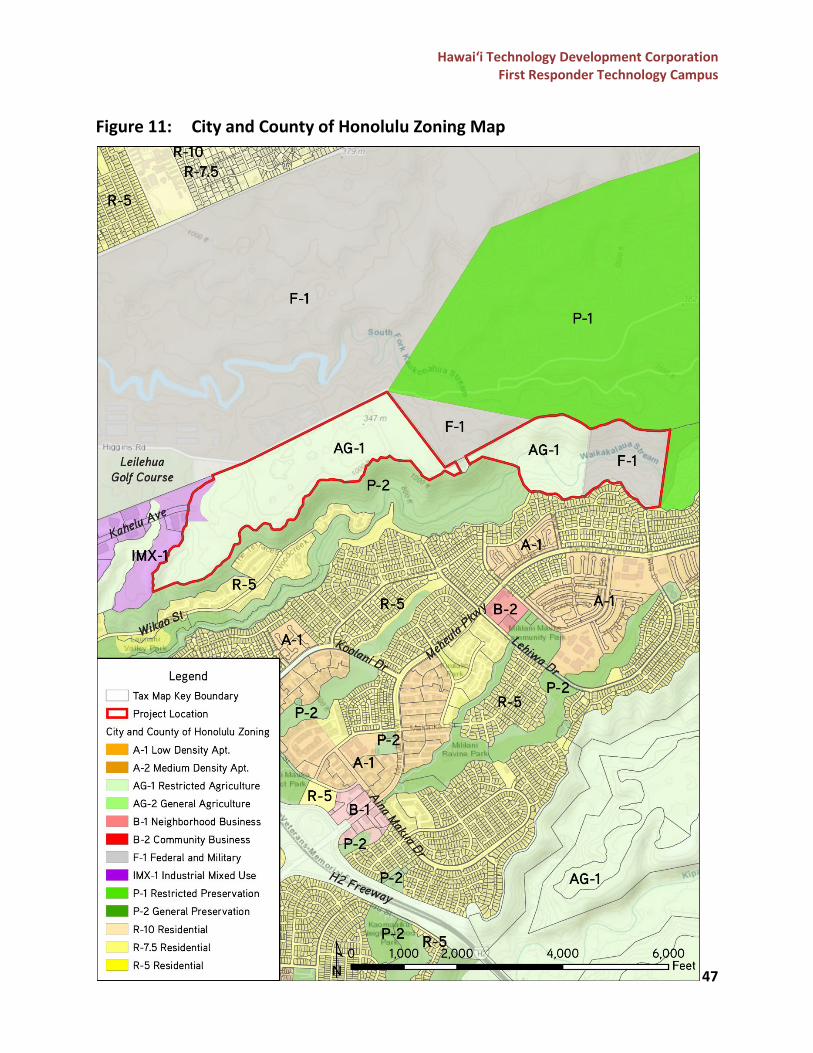
Hawai‘i Technology Development Corporation First Responder Technology Campus
47
Figure 11: City and County of Honolulu Zoning Map
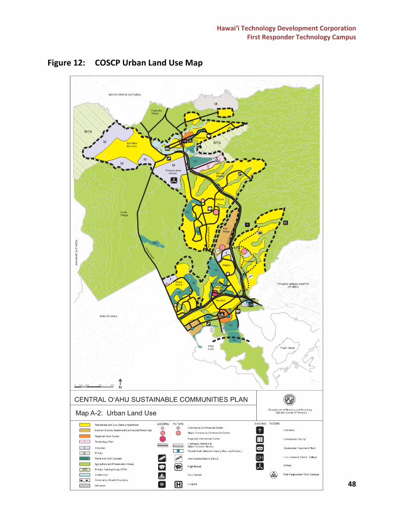
Hawai‘i Technology Development Corporation First Responder Technology Campus
48
Figure 12: COSCP Urban Land Use Map
Hawai‘i Technology Development Corporation First Responder Technology Campus
49
Special Management Area
The City and County of Honolulu has designated the shoreline and certain inland areas of O‘ahu as being within the Special Management Area (SMA). The SMA areas are designated sensitive environments that are protected in accordance with the State’s CZM policies, as set forth in ROH Chapter 25. The project site is not located within the SMA, as it is approximately 10-miles from the nearest coastline.
Ola: O‘ahu Resilience Strategy
The O‘ahu Resilience Strategy, prepared by the City and County of Honolulu’s Office of Climate Change, Sustainability, and Resiliency, identifies 44 actions that directly address the challenge of long-term affordability and the impacts of climate change. While the FRTC does not directly address the listed actions, it does provide support for the lead and implementing partners to fulfill the general goals identified in the following pillars.
• Pillar I. Remaining Rooted o Goal 1: Supporting Affordable Housing Development
Discussion: The FRTC will include areas for private development that will include workforce housing, which will help to address the need for housing in O‘ahu. The development of the workforce housing will support a live, work, play environment at the FRTC and in the surrounding community.
• Pillar II. Bouncing Forward o Goal 1: Pre-Disaster Preparation o Goal 2: Effective Disaster Response o Goal 3: Successful Disaster Recovery
Discussion: The purpose of developing the FRTC is to create one campus that will meet the operational and training needs of Federal, State, and County first responder agencies to provide their services to the island and the State, and to create greater efficiencies in our State’s response to natural and manmade disasters and scenarios. Locating multiple agencies on one campus will create an environment conducive to cross-collaboration and will also allow for innovation of new technologies or processes to increase our State’s disaster response and recovery.
Hawai‘i Technology Development Corporation First Responder Technology Campus
50
PROJECT ALTERNATIVES No-Action Alternative
Under the No-Action alternative, the FRTC would not be built, and the location of first responder agencies’ headquarters, offices, and training facilities will remain the same until individual action is taken by each agency. Without the proposed FRTC, the cost, time, and effort necessary to find the appropriate location to build individual facilities for each agency will be far greater than that which will be spent to build the facilities on one shared campus. The existing facilities will continue to age and/or become overcrowded and will continue to be vulnerable to the effects of sea level rise, climate change impacts, and other natural hazards. In addition, agencies will continue to send their trainees to mainland facilities at high costs and with limited exposure due to the lack of facilities and space required to train within the State. Additionally, there would be no positive benefit of new employment opportunities, including new jobs created through construction and through the operational employment to support the campus and its accessory uses.
Delayed Action
The Delayed Action alternative involves postponing design and construction of the FRTC to a date in the future. The impact of this alternative is like the No-Action alternative, as the agencies will continue to experience aging and deteriorating facilities that are overcrowded and will continue to incur high costs to send trainees to mainland facilities. In the long-term, delaying construction to a future date could potentially lead to more money spent on short-term solutions to address the aging and overcrowded facilities. In addition, construction and material costs would also continue to rise due to inflation, making the construction of the FRTC more difficult to achieve. Designing a campus to serve nineteen (19) different Federal, State, and County first responder agencies involves a significant effort including coordination, time, and commitment from all stakeholders involved. Should the construction of the FRTC be postponed, it is likely that the design and coordination process would need to be reconfirmed to update the needs and interest of each agency. This would require more time and money spent for the construction of the FRTC to be achieved.
Alternative Sites
Alternative sites for the location of the FRTC will be discussed and analyzed in the Draft EIS. The criteria for identifying potential alternative sites for the FRTC will include, but not be limited to, property size, ownership, centralized location, existing infrastructure, risks associated with site development, required entitlement process, and vulnerability to sea level rise and natural hazards.
Hawai‘i Technology Development Corporation First Responder Technology Campus
51
AGENCIES AND PARTIES TO BE CONSULTED Early Consultation
During the development of the project, early consultation was conducted with DPP, BWS, and HECO to discuss the requirements that the project would need to meet for each agency. Below is a summary of the meetings held with the agencies. DPP On September 4, 2020, the project team met with Kathy Sokugawa, Katia Balassiano, Tim Hiu, and Eugene Takahashi from DPP to provide an overview of the FRTC and to discuss the zoning requirements for the project. Most of the property is zoned AG-1 by the County; however, a small portion of Parcel 057 is zoned I-2, which could be attributed to a discrepancy in the mapping when MTP Phase I was being considered. The project team indicated that a market study was currently being prepared to determine if there is a demand for other private uses such as commercial, industrial, hotel, office, etc. on the campus. DPP requested a revised master plan of the FRTC once the users are determined so that they could recommend a path forward, whether it is rezoning of the property or conditional use permitting. DPP also indicated that community outreach would be needed, especially if the government uses will include a firing range, explosives, helicopters, and other types of uses that the surrounding community might object to. The project team indicated that community outreach will be done as part of the EIS process. On April 30, 2021, the project team met with Dean Uchida, Dina Wong, Katia Balassiano, Lisa Imata, and Eugene Takahashi from DPP to provide an update and an overview of the project to the new director of DPP, Dean Uchida. DPP indicated that the revised COSCP was published in February 2021, and that the FRTC was identified in the plan. Due to the range of uses proposed at the FRTC, DPP indicated that applying for a PRU approval may be more fitting for the project instead of applying for rezoning permits for each use proposed at the campus. DPP was in the process of updating the LUO and indicated that the language for PRUs may be modified to include multiple entities and uses within one PRU boundary. BWS On September 22, 2020, the project team met with Barry Usagawa, Robert Chun, and Joyce Lin from BWS to provide an overview of the FRTC project and to discuss BWS’ requirements fpr potable water access to the site. BWS indicated that during the development of MTP Phase I, Castle & Cooke financed a new well in Wahiawā that provided water to their 994-ft elevation reservoir that services Phase I. The well was slated to provide water for Phase II, but the allocation is under control by Castle & Cooke and was not transferred to the State when Parcel 057 was purchased. BWS indicated that a second reservoir at an elevation around 1,150-ft would be required to service Phase II. A booster pump near the existing 994-ft elevation reservoir will also be required to pump water to the new 1,150-ft reservoir.
Hawai‘i Technology Development Corporation First Responder Technology Campus
52
In addition, BWS indicated that the existing wells in Wahiawā may have additional source capacity, but BWS would need to get an increased allocation from the CWRM to increase the current amount pumped out of the Central O‘ahu Aquifer to accommodate the demands of the FRTC. Should this direction be pursued, the State may need to finance any upgrades to the existing well and transmission infrastructure that would be required to pump water from the existing Wahiawā well(s) to the 1,150-ft reservoir. BWS recommended that once the amount of first responders to be located at the FRTC is determined, the 1986 Mililani High Tech Park Waster Master Plan should be updated by the project team. The Water Master Plan will need to be reviewed and approved by BWS. HECO On July 12, 2021, the project team met with Scott Seu, Jim Alberts, Bob Isler, Rudy Tamayo, Keola Siafuafu, Erin Kippen, Darcy Endo-Omoto, and Jack Shriver from HECO to provide an overview of the FRTC project and to informally explore mutual interests and opportunities for the HTDC and HECO. HECO indicated that there was the potential for varied levels of involvement for them at the FRTC, including providing electrical service to the project site (short-term goal), installing company equipment and/or generation equipment on the site (mid-term goal), and/or becoming a tenant for operational purposes at the FRTC (long-term goal). The short-term goal would be to provide power to the first phase of construction of the FRTC. The mid-term goal would be for HECO to provide facilities management for all facilities and maintenance needed at the FRTC. The long-term goal would be for HECO to install a new power generation site at the FRTC. HECO indicated that they would need the power/energy requirements for each phase of construction of the FRTC to further explore their involvement with the project.
EISPN Consultation
Per HAR §11-200.1-23, consultation with appropriate Federal, State, and County agencies, organizations, and individuals is required prior to filing a Draft EIS. A preliminary list of the agencies, organizations and individuals that will be contacted during the publication of the EISPN and prior the filing of the Draft EIS is provided in Table 5 below. Additional parties or individuals may be added during the EISPN and/or the Draft EIS process.
Table 5: List of Agencies and Parties to be Consulted
Agency/Name Federal Agencies U.S. Department of Homeland Security, Immigration and Customs Enforcement, Homeland Security Investigations Federal Bureau of Investigation U.S. Department of Justice, U.S. Marshals Service U.S. Department of Justice, Bureau of Alcohol, Tobacco, Firearms and Explosives
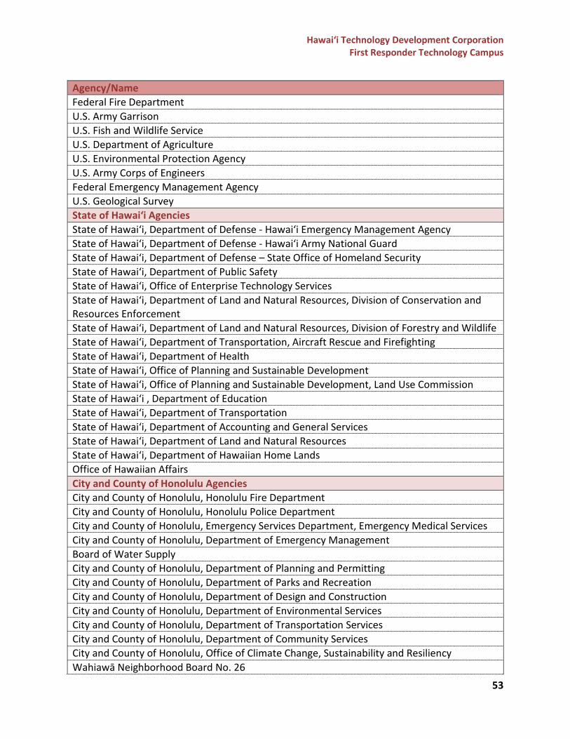
Hawai‘i Technology Development Corporation First Responder Technology Campus
53
Agency/Name Federal Fire Department U.S. Army Garrison U.S. Fish and Wildlife Service U.S. Department of Agriculture U.S. Environmental Protection Agency U.S. Army Corps of Engineers Federal Emergency Management Agency U.S. Geological Survey State of Hawai‘i Agencies State of Hawai‘i, Department of Defense - Hawai‘i Emergency Management Agency State of Hawai‘i, Department of Defense - Hawai‘i Army National Guard State of Hawai‘i, Department of Defense – State Office of Homeland Security State of Hawai‘i, Department of Public Safety State of Hawai‘i, Office of Enterprise Technology Services State of Hawai‘i, Department of Land and Natural Resources, Division of Conservation and Resources Enforcement State of Hawai‘i, Department of Land and Natural Resources, Division of Forestry and Wildlife State of Hawai‘i, Department of Transportation, Aircraft Rescue and Firefighting State of Hawai‘i, Department of Health State of Hawai‘i, Office of Planning and Sustainable Development State of Hawai‘i, Office of Planning and Sustainable Development, Land Use Commission State of Hawai‘i , Department of Education State of Hawai‘i, Department of Transportation State of Hawai‘i, Department of Accounting and General Services State of Hawai‘i, Department of Land and Natural Resources State of Hawai‘i, Department of Hawaiian Home Lands Office of Hawaiian Affairs City and County of Honolulu Agencies City and County of Honolulu, Honolulu Fire Department City and County of Honolulu, Honolulu Police Department City and County of Honolulu, Emergency Services Department, Emergency Medical Services City and County of Honolulu, Department of Emergency Management Board of Water Supply City and County of Honolulu, Department of Planning and Permitting City and County of Honolulu, Department of Parks and Recreation City and County of Honolulu, Department of Design and Construction City and County of Honolulu, Department of Environmental Services City and County of Honolulu, Department of Transportation Services City and County of Honolulu, Department of Community Services City and County of Honolulu, Office of Climate Change, Sustainability and Resiliency Wahiawā Neighborhood Board No. 26
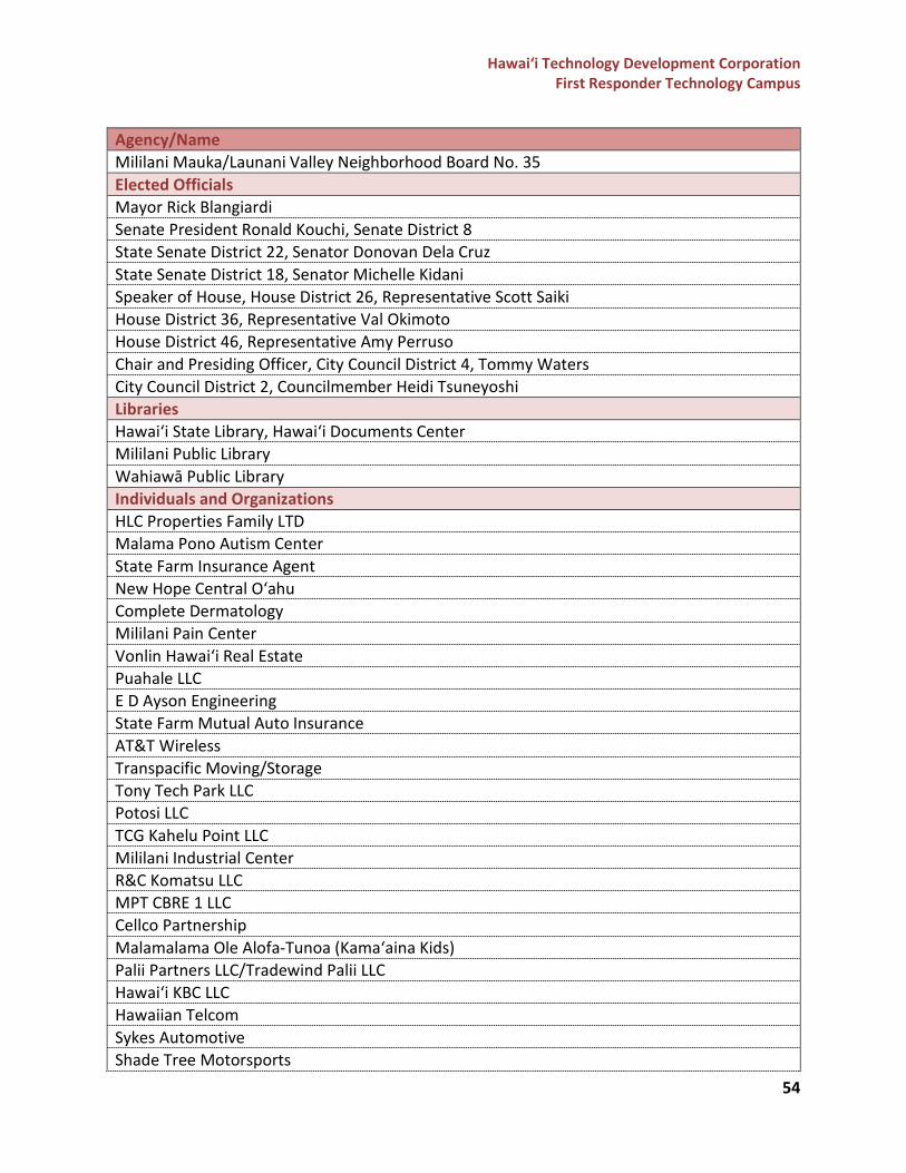
Hawai‘i Technology Development Corporation First Responder Technology Campus
54
Agency/Name Mililani Mauka/Launani Valley Neighborhood Board No. 35 Elected Officials Mayor Rick Blangiardi Senate President Ronald Kouchi, Senate District 8 State Senate District 22, Senator Donovan Dela Cruz State Senate District 18, Senator Michelle Kidani Speaker of House, House District 26, Representative Scott Saiki House District 36, Representative Val Okimoto House District 46, Representative Amy Perruso Chair and Presiding Officer, City Council District 4, Tommy Waters City Council District 2, Councilmember Heidi Tsuneyoshi Libraries Hawai‘i State Library, Hawai‘i Documents Center Mililani Public Library Wahiawā Public Library Individuals and Organizations HLC Properties Family LTD Malama Pono Autism Center State Farm Insurance Agent New Hope Central O‘ahu Complete Dermatology Mililani Pain Center Vonlin Hawai‘i Real Estate Puahale LLC E D Ayson Engineering State Farm Mutual Auto Insurance AT&T Wireless Transpacific Moving/Storage Tony Tech Park LLC Potosi LLC TCG Kahelu Point LLC Mililani Industrial Center R&C Komatsu LLC MPT CBRE 1 LLC Cellco Partnership Malamalama Ole Alofa-Tunoa (Kama‘aina Kids) Palii Partners LLC/Tradewind Palii LLC Hawai‘i KBC LLC Hawaiian Telcom Sykes Automotive Shade Tree Motorsports
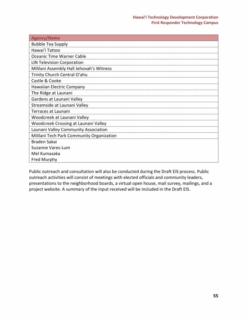
Hawai‘i Technology Development Corporation First Responder Technology Campus
55
Agency/Name Bubble Tea Supply Hawai‘i Tattoo Oceanic Time Warner Cable LIN Television Corporation Mililani Assembly Hall Jehovah’s Witness Trinity Church Central O‘ahu Castle & Cooke Hawaiian Electric Company The Ridge at Launani Gardens at Launani Valley Streamside at Launani Valley Terraces at Launani Woodcreek at Launani Valley Woodcreek Crossing at Launani Valley Launani Valley Community Association Mililani Tech Park Community Organization Braden Sakai Suzanne Vares-Lum Mel Kumasaka Fred Murphy
Public outreach and consultation will also be conducted during the Draft EIS process. Public outreach activities will consist of meetings with elected officials and community leaders, presentations to the neighborhood boards, a virtual open house, mail survey, mailings, and a project website. A summary of the input received will be included in the Draft EIS.
Hawai‘i Technology Development Corporation First Responder Technology Campus
56
REFERENCES Cultural Surveys Hawai‘i, Inc. “Draft Archaeological Literature Review and Field Inspection Report for the First Responder Technology Campus Master Plan, Waikele and Waipio Ahupua‘a, ‘Ewa District, O‘ahu TMKs: [1] 9-5-002:039 and 057.” Prepared for SSFM International, Inc. on behalf of the State of Hawai‘i, Department of Accounting and General Services (DAGS) and Hawai‘i Technology Development Corporation (HTDC). July 2021. City and County of Honolulu, Department of Planning and Permitting. “Central O‘ahu Sustainable Communities Plan.” February 2021. City and County of Honolulu. The Revised Ordinances of Honolulu, Land Use Ordinance, Chapter 21. 19 March 2021. Federal Emergency Management Agency. “Flood Hazard Areas for the State of Hawaii.” State of Hawaii, Office of Planning and Sustainable Development, 18 March 2021, https://files.hawaii.gov/dbedt/op/gis/data/s_fld_haz_ar_state.html Przym Consulting, LLC. “Due Diligence Report, Mililani Tech Park Phase II, TMK 9-5-002-057.” Prepared for Hawai‘i Technology Development Corporation. 07 June 2017. State of Hawai‘i, Department of Land and Natural Resources, Division of Aquatic Resources. “Streams (DAR).” 2008. State of Hawai‘i. Hawai‘i Administrative Rules, Title 11 Department of Health, Chapter 200 Environmental Impact Statement Rules. 09 August 2019. State of Hawai‘i. Hawai‘i Revised Statutes, Chapter 205, Land Use Commission. 2015. U.S. Department of Agriculture, Natural Resources Conservation Service. “Soil Survey Geographic (SSURGO) database for Island of Oahu, Hawaii.” 16 September 2019, https://websoilsurvey.sc.egov.usda.gov/ U.S. Census Bureau. (2010). 2010 Census. U.S. Fish &Wildlife Service. “National Wetlands Inventory, Surface Waters and Wetlands.” 01 May 2021.
-end-


![FIPS 201 EVALUATION PROGRAM · PIV and PIV-I in E-PACS are detailed in the FIPS 201 Evaluation Program Functional Requirements and Test Cases [FRTC] document. Office of Management](https://img.pdfslide.net/doc/110x75/5ee11b65ad6a402d666c1bf8/fips-201-evaluation-program-piv-and-piv-i-in-e-pacs-are-detailed-in-the-fips-201.jpg)


![FIPS 201 EVALUATION PROGRAM · 2017-04-05 · PIV and PIV-I in E-PACS are detailed in the FIPS 201 Evaluation Program Functional Requirements and Test Cases [FRTC] document. Office](https://img.pdfslide.net/doc/110x75/5ee11b52ad6a402d666c1be8/fips-201-evaluation-program-2017-04-05-piv-and-piv-i-in-e-pacs-are-detailed-in.jpg)