Embed Size (px)
Citation preview
42L04NE0203 2.3043 METCALFE LAKE 010
GEOLOGICAL
REPORT
b y
W. YZERDRAAT
and
P. L A W N I K A N I S
General
This report to the Ontario Ministry of Natural Resources
covers geological work performed on sixteen claims in the Metcalfe Lake
Area, Thunder Bay Mining Division. The bulk of the survey work was done
by the second author during early July and early September, 1979.
The claims traversed are part of a 32-claim group covering
the southern part of McDonough Lake, almost all of Metcalfe Lake, the
area between these lakes, and the area south of McDonough Lake. An
earlier geological report to the Ministry, dated 1979 01 06 and signed
by the present senior author, dealt with seven claims in the northern
sector of the same group. In the following, reference will be made to
this earlier report.
The geological work on claims TB 457149, 457150, 459704,
464503 to 464505, 464507, 46450S, and 465131 to 465134 was reported to
the Mining Recorder at Thunder Bay on July 14. Further work, on claims
TB 464509 and 464510, was reported on September 3, and finally the work
on TB 459700 and 459701 was reported on September 14, 1979.
All claims covered by this report are recorded in the name
of Walter Yzerdraat of Ottawa, Ontario.
LOCATION AND ACCESS
A detailed description of access routes to the Metcalfe-McDonough
Lakes area can be found in the earlier geological report by the senior author;
briefly, there are three ways to reach the grounds: from the north by walking
in along the. Tashota-Onaman Winter Road which traverses the grounds 8 km south
of the CNR Transcontinental Line near Tashota; from the east by flying in over
a distance of about 70 km from Cordingley Lake north of Nakina, and from the
south by flying in over a distance of some 60 km from Nezah Lake, just south
of Ontario Highway 11 between Longlac and Beardmore.
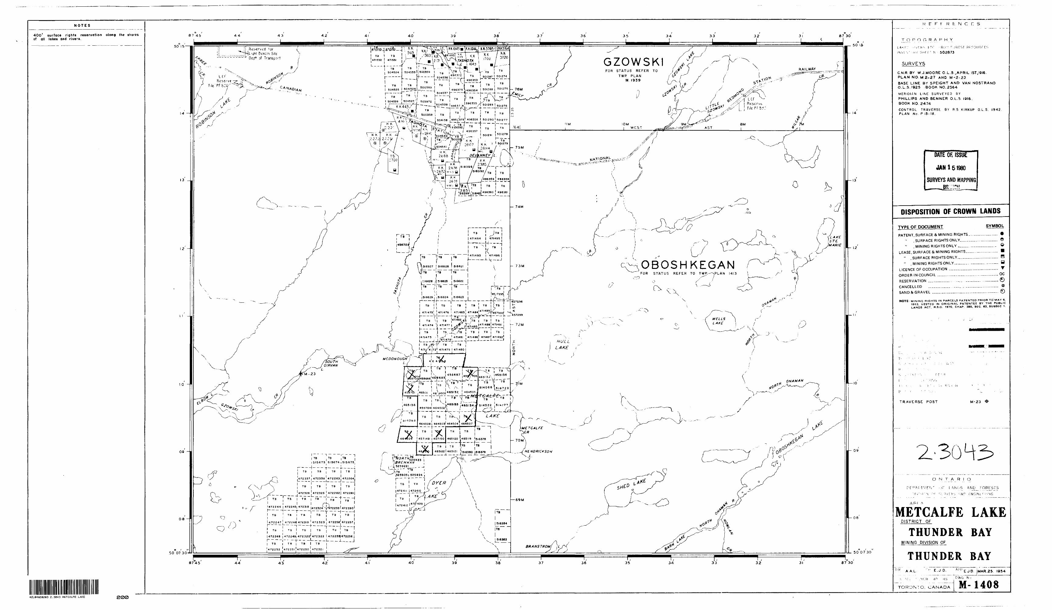
The centre of the claim group is at latitude 50 10' north,
longitude 87O 39' west; both lakes covered by the claim group are shown on
Mining Map M 1408, and the general area is within the boundaries of NTS map
sheet 42 L/4.
GENERAL GEOLOGY
Various authors have summarily described the geological character
of the Metcalfe Lake Area (see the previous geological report). All volcanic
and metasedimentary rocks on the claim group are of Archean age. Concordant
mafic intrusions, here designated as amphibolites (le) are slightly younger,
while all gabbroic and felsic intrusions may be of Proterozoic age. The
latter conclusion is based on the rock fabric resulting from tectonism, and
on mineral composition. The greenstone sequence can be considered as part of
the Wabigoon system. Most of the surveyed area is covered by Pleistocene-to-
recent unconsolidated sediments.
With regard to observational evidence (pillow-top determinations j,
crossbedding and graded bedding), the volcanic-sedimentary rocks can be
arranged in order of decreasing age: basalts, andesite, argillite-arkose,
reworked felsic volcanics, and felsic tuffs.
On the basis of our previous survey, we reported on a rock type
designated as andesite/dacite. The present, more detailed work has led us to
believe that some of the apparently-volcanic rocks in this group, such as the
banded flows and mafic tuffs, are actually reworked volcanic material and
should be classified as metasediments.
The regional metamorphic grade is that of the middle-greenschist

facies. This conclusion is supported by the absence of almandine garnet
and staurolite in the thin sections so far examined. In conjunction with
the emplacement of felsic plutons nearby, hydrothermal alteration and,
possibly, contact-metarnorphism, have affected rocks of Kenoran age in the
area covered by this report. The basalt/andesite is locally silicified and
sericitized. Carbonatization occurs close to such felsic plutons.
The folding of the volcanic and metasedimentary rocks is such that
they now exhibit a generally northeast-southwest trend, in bedding as well as
in foliation. This trend, with local modifications, is pervasive in the
Metcalfe Lake Area.
ECONOMIC GEOLOGY
The Metcalfe Lake Area, situated between the Tashota gold area
and the Onaman River czunps of the early twenties, has received relatively
little attention from old-time prospectors, who did not have the means to
cope with the problems of deep overburden and water which mask much of the
bedrock. Lately, however, several mining- and exploration companies have
staked ground in the area and are still conducting surveys.
The general economic significance of the Tashota-Onaman region
has been described in the previous geological report.
THE PRESENT SURVEY
The traverses were run along grid lines and cut claim lines.
On some of the claims, the geological work had been preceded by ground-
magnetometer and radiometric work. The grid was set up under theodolite control
in early 1976, and has been expanded periodically.
The main baseline (MSL) cuts across the widest part of Metcalfe
Lake in a direction 54O east of north; the traverse lines are spaced 100
metres apart, and a station interval of 25 metres is standard. In most of
the work done to date, readings have been taken at half-station intervals
or less.
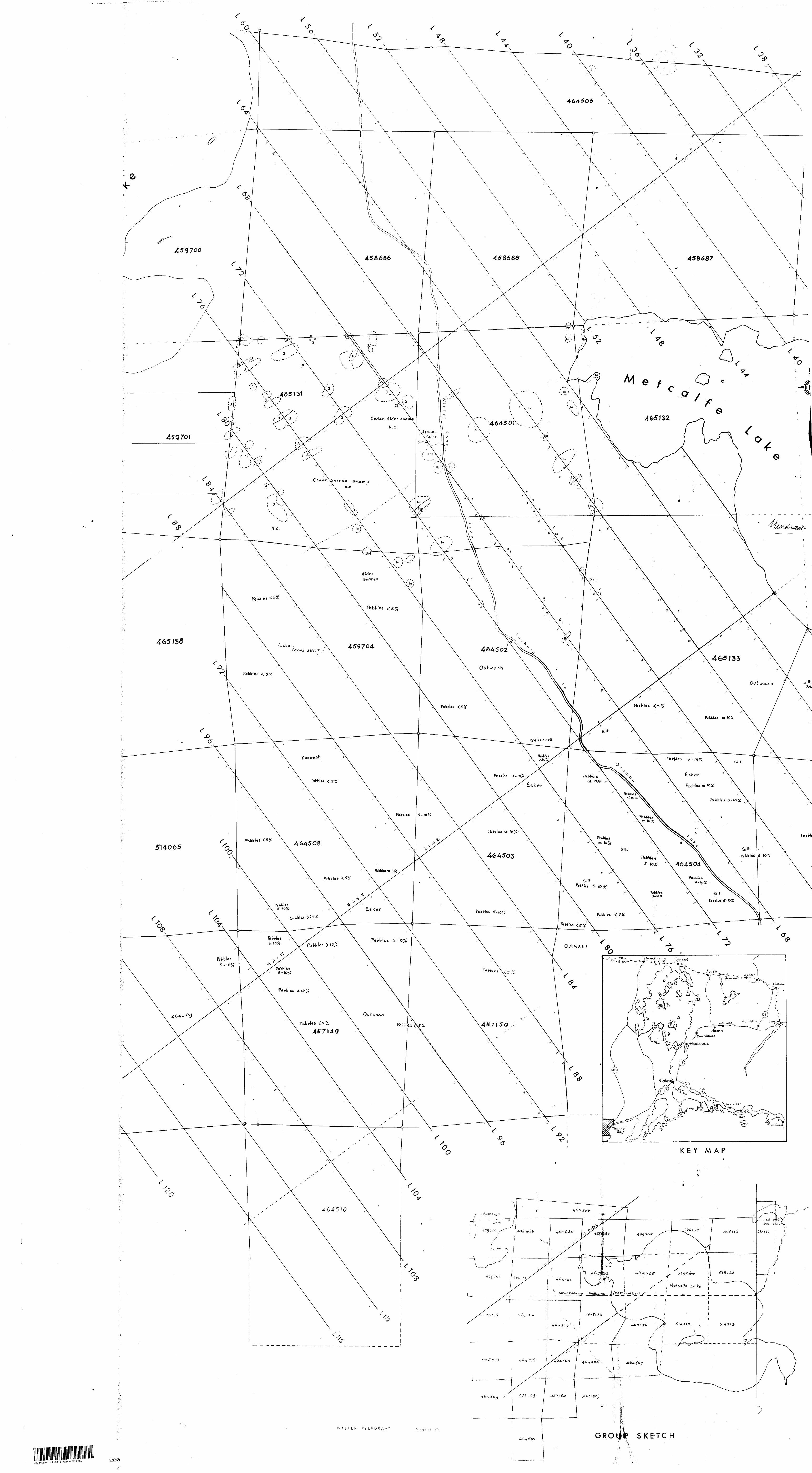
LITHOLOGY AND STRUCTURE
Four main rock types were identified in this survey:
A. Mafic Volcanics: pillowed, flow-type, sub-porphyritic and
amygdaloidal basalt and andesite;
B. Felsic Volcanics: rhyodacite/dacite and rhyolite tuffs;
C. Sediments: quartz-bearing "argillites", reworked felsic volcanics,
and iron formation;
D. Mafic intrusions:
i) Concordant: "amphibolite";
ii) Discordant: gabbro plugs.
The rocks of type D are separated into lOa and lOb, respectively,,
for mapping purposes.
Sills or dikes could not be traced with certainty in the surveyed
area; therefore, none of the rocks are classified as diabase. It should be
pointed out, however, that the gabbroic types lOa and lOb are equivalent,
mineralogically, to the rock types previously designated as lOa and lOb dia
bases in our previous report.
As far as the present survey is concerned, rocks of type C are
the most abundant ones, followed by those of types A, D and B, in that order.
No criteria could be established to differentiate basalts from andesites.
This difficulty is due to the abundance of the metamorphic mineral chlorite,
which makes field-identification impossible. Only bulk analysis can provide
the answer to the problem; meanwhile, we provisorily introduce a class of
"basalt/andesite" type rocks.
No evidence was found for major displacements, resulting in
shear- or fault zones. No large displacements disrupt the general structural
and stratigraphic trends. Minor folds are common in rocks of types B and C,
but no definitive vergence pattern has emerged so far. This lack of tidiness
is due to refolding of crossbeds and crenulated cleavage planes.
Lineation, foliation, schistosity and bedding trends are fairly
consistently between 180 and 240 degrees, and the dips are mostly steep to
vertical. As yet, no synform-antiform pairs can be outlined.

A. Ma f ic Volcan ics
These fine-grained rocks appear in the pillowed form in a zone
roughly parallel to the MBL and starting 200 metres northwest of it; to the
southeast of this pillow-line, flow rocks predominate. This conclusion is
based on observation of the sparse, small outcrops found in the generally
drift-covered part of the area traversed by the MBL.
The usual genetic sequence for mafic volcanics is that flows
(massive) are followed by pillow structures and vesicular textures. Such a
classical sequence can not be identified in the surveyed area. The contact
(as inferred from the present work) between pillowed volcanics and the
metasediments occurs roughly along a line some 200 metres southwest of the
ABL 800 NW; hence, the outcrop width of the pillow zone is 500 100 metres.
Overburden obscures whatever rock type may occur southeast of the MBL.
The sizes of the pillows vary from less than 10 cm to 50 cm, for
an average of 30 cm. Tops always face N to NW, as determined in 15 recorded
and a number of casual observations. Although we cannot yet say what the
attitude of the plane of deposition must have been, our observation of top
orientations seems to conflict with some recent publications by others.
The rock type designated as (le) amphibolite in our previous report,
has been found to be a mafic-derived metasediment which should have been termed
a chlorite-plagioclase-hornblende schist, with or without detrital quartz
grains. It is, therefore, reclassified as a metasediment of mafic derivation,
and given the map symbol (8).
B. Felsic Volcanics^
Rocks of this type (units 4, 4a, 5 and 5a) are uncommon in the
surveyed area; they prevail on some of the easternmost claims. One outcrop
of rhyodacite (3-4a), which is strongly sericitized, was located strati-
graphically above metasediments on Line 76 near station 88. It is not ex
tensively exposed, and it has not been found in outcrop on adjacent grid
lines. Its composition is quartz, sericite and feldspar in a
modal ratio of 50:25:25. The relatively high radiometric reading over this
outcrop indicates a potassium content higher than that of the surrounding
rocks. The unit was hydrotherroally altered during or after deposition. It
was noted, however, that the rocks above and below this unit are not strong
ly affected by this type of alteration. Another outcrop of altered rhyodacite
occurs about 35 metres due east of the easternmost tip of the south arm of
McDonough Lake; here, sericite is less abundant.
One outcrop of rhyodacite-rhyolite tuff occurs above strata of
reworked intermediate-to-felsic volcanics and argillites on claim TB 459701.
It is the westernmost outcrop found on a former grid line (shown as a dotted
line on the map). The modal composition is quartz:feldspar:hornblende4-biotite
70:20:10. We consider this occurrence important for two reasons: a) felsic
volcanics underlie the. souteastern part of Metcalfe Lake and occur around Dyer
Lake; b) the outcrop on the old Crossline on claim 459701 is the first
occurrence of felsic volcanics found on the claim group close to the. major
pluton west of the claims, and may have economic significance. The pyrite
content of this unit is greater than \'/,,
It would be important to locate similar rocks farther west, but:
unfortunately the terrain descends into deep swamp and muskeg where no more
outcrops could be found. Otherwise, it would have been possible to give a
more detailed description of this lithological unit. As it is, we can only
say that it is a fine- to medium-grained volcanic rock of simple mineralogy,
which displays no bedding or other sedimentary character.
C- Me tase d iment s
These are the most abundant rock types in over half the mapped
area, disregarding the areas of deep pleistocene drift. Their texture is
fine-grained (less than l mm) and they do not fit the classificiation scheme
we used in the previous report. These rocks may best be described as being
3/4 argillite and 1/4 arkose; a rational designation would be: quartz-chlorite-
amphibole-feldspar schist. They deceptively resemble mafic-to-intermediate
volcanics, even at fairly close inspection, but careful observation has led
us to reclassify them as metasediment!; on the strength of the following
features: lamination, graded bedding, crossbedding, quartz-chert banding,
and the presence of reworked remnants of mafic volcanics and shards.
It seems most likely that the quartz-bearing argillites were
derived from mafic-to-intermediate source terrains located to thenortheast
and west-northwest . The sedimentary pile appears to occupy a topographic
low. Volcanic piles had been built up in the northeast and, possibly, in
the west-northwest. Crossbed measurements indicate the transport of debris
from the northeast as well as from the west. The relative abundance of chert,
the fine lamination, and the presence of iron formation all imply a fairly
stable deposition environment.
The reworked felsic volcanics are intermixed with these
"quartz-bearing argillites". They have been found on claims TB 459700,
459701, and 458686. These form the northwestern corner of the claim group.
In a few localities they resemble arkosic sandstone, but in most outcrops
there are mixtures of argillite and reworked components. Occasionally,
lapilli and vesiculate fragments occur in these sediments. They are fine
grained and start occurring, stratigraphically speaking, only where felsic
tuffs are present. The reworked volcanics exhibit the same sedimentary
structures as the "argillites".
The last; type of sediment is a two-to-three metre wide band of
iron formation, which might be more properly classified as an exhalation
deposit. This band is very strongly ferromagnetic and is made up of alter
nating bands of chert or cherty clay, and magnetite. The overall
content is 25-57,. The deposit is fine- to very fine-grained. This band,
first identified on Line 76, could not be traced across Lines 72 and 80,
but at the same stratigraphic level on Line 72 there is a cherty band with
traces of pyrite, and interbedded with argillite, representing the same
marker hprizon. No disruption of this excellent marker seems to occur
from Line 76 to Line 56, and this leads to the conclusion that no passive
flow, nor any major folding, shearing or faulting, have influenced the
present stratigraphy.
^ - Maf ic I.nt rus i cms
The concordant "amphibolites" were mentioned in a previous
section under the heading of General Geology. They are fine-grained and
massive, and consist of chlorite, hornblende and plagioclase (in order of
decreasing abundance) .
The gabbro plugs, identified as lOa and lOb on the map, resemble
diabase compositionally, and our identification of certain "dikes" on the
previous map may have been in error. More detailed magnetometer work will
be required to verify this assumption. The intrusions are generally medium-
grained, contain plagioclase, pyroxene and microcline (in order of decreasing
abundance) plus oxides, and cut through sediments as well as volcanics.
Small contact aureoles and quartz veining are common adjacent to these intru
sions. The quartz veins are usually barren, but some pyrite was recognized
occasionally.
Between the previous survey and the present one, a specimen of
the diabase of type lOc was examined in thin section, and this led us to
revise our opinion. Both authors are now convinced that this rock is
actually a sediment derived from mafic volcanics; its modal composition is
plagioclase : hornblende : chlorite : quartz :s 30 to 35 : 30 : 15 : 5, with
minor epidote and oxides. The category lOc no longer appears in the
present classification scheme.
Plelstoce ne
In areas of extensive, deep overburden, we used the following
criteria to classify the unconsolidated pleistocene sediments:
1) the silt : sand : clay ratio of the matrix
2) pebble sizes
3) pebbel : matrix ratio
4) pebble type
5) depth (thickness) of the pile
6) associated vegetation
Using this classification, we outlined a ridge system extending
from the SW shore of Metcalfe Lake to Line 124 (the farthest survey line
so far cut in the southwestern corner of the claim group), as well as
outwash debris in the flatter areas at the base of the system, and clay-
rich swampy areas. The average width of the ridge system is 400 metres,
and it has a general NE - SW trend. The asymmetric topographical profile,
with the steeper slope facing northwest, may be related to bedrock topo
graphy .
In the vicinity of the MBL, a zone extending from about 50 m. y..
north of this baseline to 150 m south of it, shows a composition with J.0%
pebbles (locally somewhat higher) and a silty matrix. The zone northwest
of this, over a width of about 650 metres, has less than 5% pebbles (with
none visible locally) and again a silty matrix. The zone southeast of the
main zone, with a width of about.125 metres, has 5 to 10% pebbles in a
silty matrix. In the flat areas only silt and clay-size particles are
present. The. silt, with an average grain size of 0.125 mm or less, makes
up 90 to 95^ of all sediment in the ridge-system and outwash deposits;
no sand (with grain size of 0.5 mm or more) was found. Thus, we are
dealing with a distinctly bimodal size distribution - a somewhat puzzling
phenomenon when reviewing possible modes of deposition.
In the pebbles, mafic volcanics and granitoid rocks predomi
nated with 30% each. Felsic volcanics were the source of about 20X of
the pebbles, and gneisses provided 10 to 15% of them. These ratios are
consistent over the entire ridge, system inspected from Line 40 on claim
TB 465134 to Line 124 on claim TB 464509 - a distance of 2100 metres.
The direction of transport could not be ascertained, because we could
not identify any crossbedding or pebble imbrication. From more general
considerations, we. can say that we are dealing with an esker in which the
direction of transport was from northeast to west-southwest. No further
attempt is made here to reconstruct the parameters of deposition.
Qpnelus ions and recommendation
No major stratigraphic revision had to be made since the
previous survey. In a third survey, the eastern and southeastern areas
should be studied, as well as the two remaining claims along the western
boundary of the group.
OTTAWA, 1979 09 17
/,} f y ) f? f t , ), X -, ,
r42L04NE0203 2.3843 METCALFE LAKE
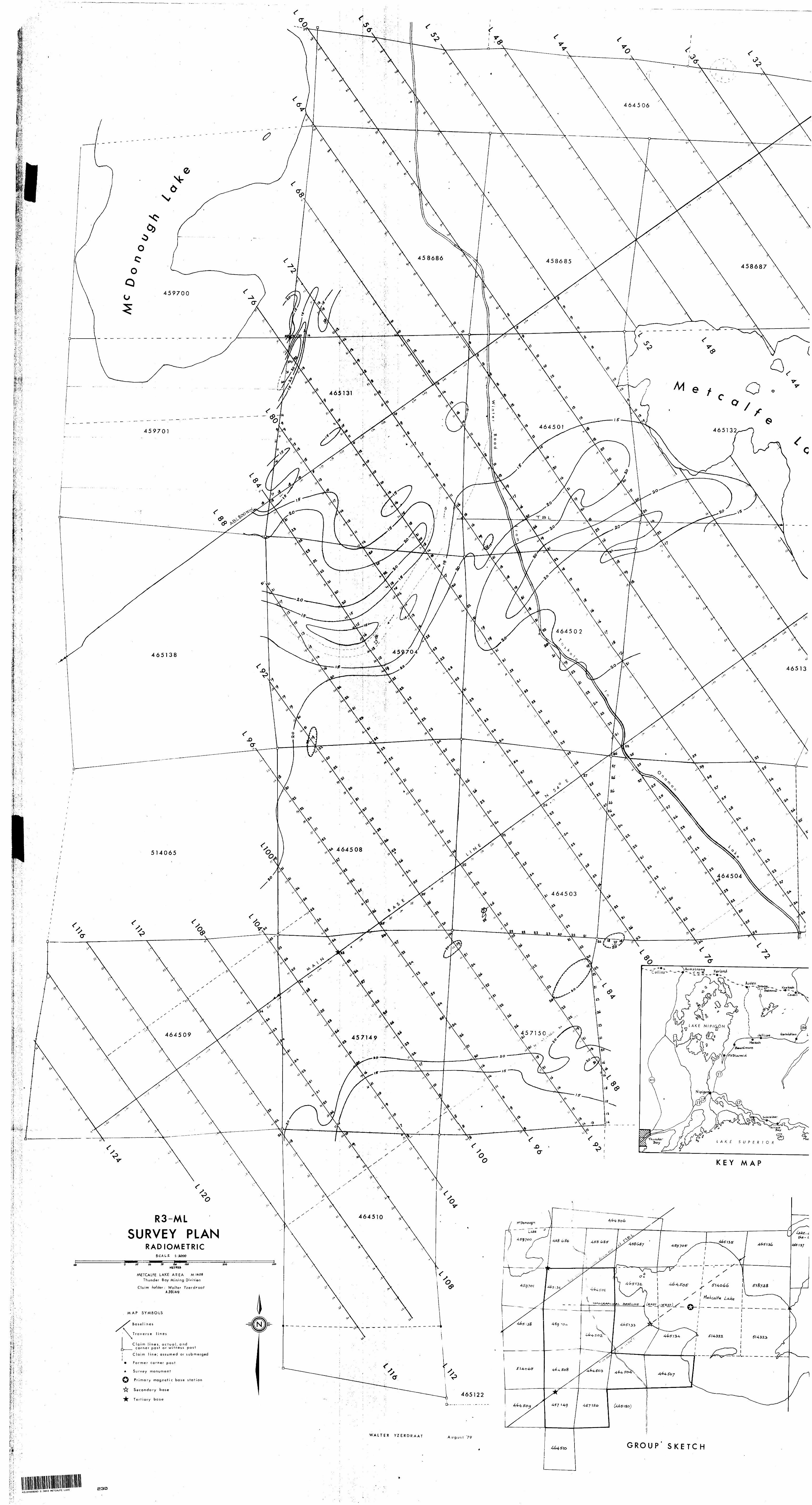
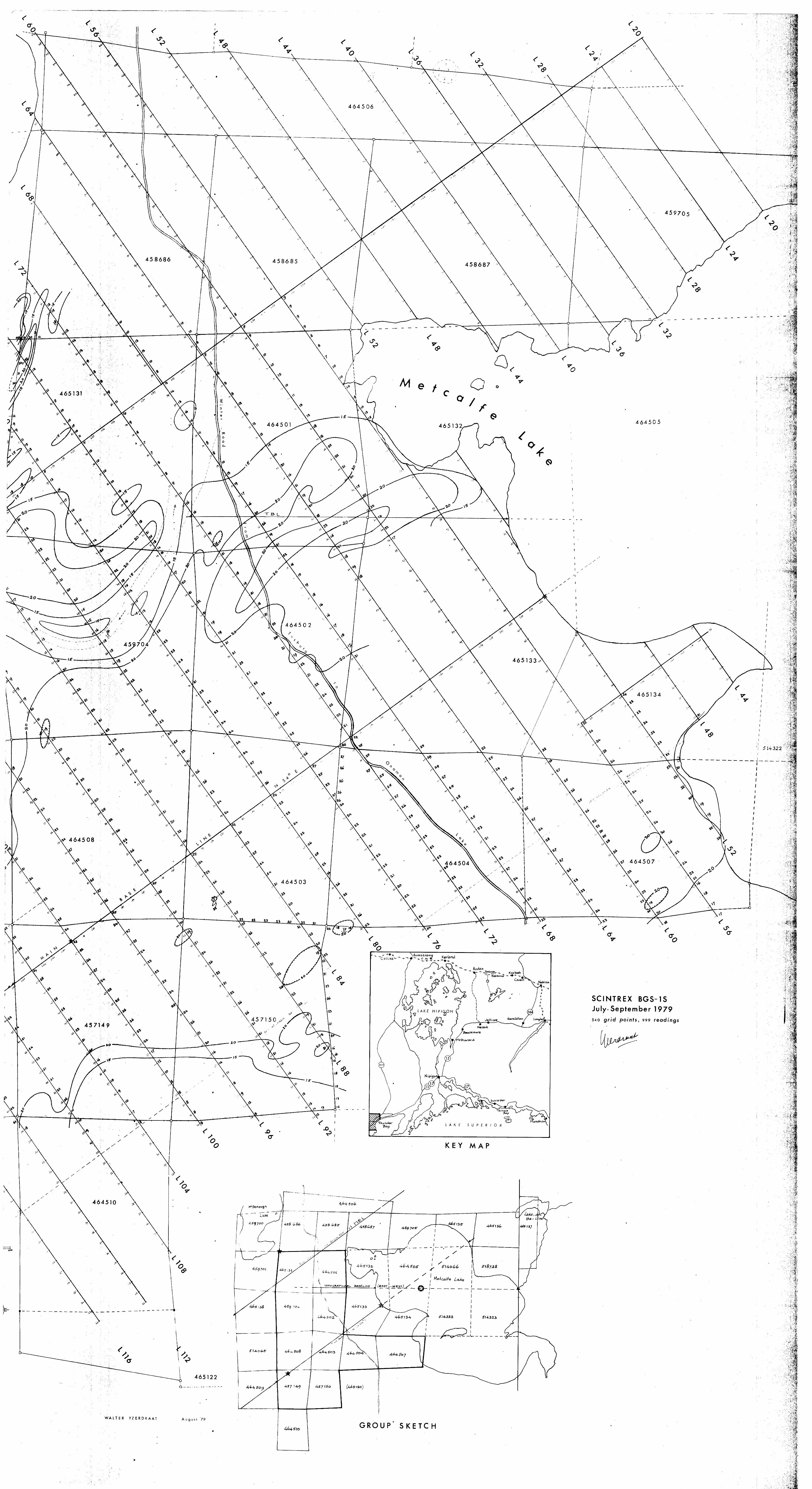
REPORT ON A RADIOMETRIC SURVEY
IN THE METCALFE LAKE AREA
by
WALTER YZERDRAAT
GENERAL
The radiometric field work for this survey was done during
the second week of July, 1979, on claims TB 457149, 457150, 459704,
464501 to 464503, 464508, and 465131, and reported to the Thunder Bay
Mining Recorder on 1979 07 15. The remaining two claims, TB 464504
and 464507, were traversed immediately afterwards and this work was
reported separately on 1979 07 31.
Field assistants were D. Tiong and P. Lawnikanis, both
of Ottawa-Carleton. On all claims, the grid used had been cut previous
ly for the. purpose of other geophysical and/or geological work.
All the work was done with a Scintrex BGS-1S scintillometer.
The intention had been to investigate outcrops or areas with anomalously
high readings in more detail with a Scintrex GIS-3 gamma-ray spectrometer,
which was on hand for the purpose. As none of the claims showed any
evidence of such anomalies, no gamma-ray spectroscopy was attempted.
In general, the latter procedure is tedious, time-consuming, and of
little practical value unless the low-energy broadband count is well
above 30 cps.

LOCATION AND ACCESS
Tlie ten claims traversed in this survey are part of a
32-claim group held by Walter Yzerdraat of Ottawa, and located around
a point in the Thunder Bay District at latitude 50O 10* north and
longitude 870 39* west, which is within the boundaries of NTS map sheet
42 L/4. All claims surveyed are in the Thunder Bay Mining Division,
Metcalfe Lake Area, Mining Map M 1408.
There are three main routes of access. A winter road, cut
for communication with the Onaman River gold camps in the early twen
ties, connects the grounds with the abandoned town of Tashota, located
at mileage 177 (west of Hornepayne, Caramat Subdivision) on the CNR
transcontinental line. The walking distance from Tashota is about 10 km
in a southeasterly and southern direction, but a somewhat shorter and
more convenient trail leads south from mileage 176 through the old
ballast pit 2 km southeast of Tashota.
The winter road has been damaged badly north and south of
the Gzowski Creek crossing by traffic with heavy machinery in recent
months, but the crossing of the creek itself has been facilitated by the
construction of a new, sturdy bridge.
The other routes of access are by air from Nezah Lake and
Cordingley Lake, respectively. Nezah Lake is less than l km south of
Provincial Highway 11 between Beardmore and Longlac, and the air distance
from there to Metcalfe Lake is roughly 60 km in a direction a few degrees
east of north. It is the most convenient route for those who drive in
from Thunder Bay or from places in Eastern Canada.
Cordingley Lake is some 5 km north of Nakina, a small town
and regular stopping place for VIA trains on the transcontinental line
linking Toronto and Montreal with Vancouver. The train time from Montreal
to Nakina is about 24 hours. The air distance from Cordingley Lake to
Metcalfe Lake is 70 km in an almost due westerly direction.
GENERA!, GEOLOGY
The area around Metcalfe Lake is underlain by a sequence of
Archean mafic to intermediate to felsic volcanics (tholeiite, andesite,
dacite-rhyolite), a fair amount of volcanic-derived sediments, and a few
large felsic plutons. Small mafic intrusions have been found to cut
nietasedlmcnts as well as older volcanics, and are therefore considered
to bc (at least in part) the youngest rocks apart from some unaltered
felsic plutons and the unconsolidated pleistocene material.
All volcanic and sedimentary rocks exhibit the effects of
low-grade (up to middle greenschist facies) regional metamorphism; there
is evidence of contact aureoles around the plutons and some of the mafic
intrusions, and hydrothermal alteration is noted in many places.
The folding pattern, with axial trends from SW to NE, indicates
a NW-SE compressive stress regime. The folding trends are locally modified
by the emplacement of the larger plutons; in the vicinity of McDonough Lake
the foliations and axial planes are more nearly N-S.
Events in Pleistocene and recent times have drastically modi
fied the pre-existing topography. The old drainage systems were destroyed,
and much of the area is now covered with eskers, outwash plateaus, moraines,
lakes and swamps, where the depth to bedrock varies from a fraction of a
metre to fifty metres or more. Glacial striae as well as esker topo
graphy indicate a NE to SW transport of unconsolidated material - a direction,
which is almost coincident with the structural trend.
ECONOMIC SIGNIFICANCE
The Metcalfe Lake Area derives its potential economic signifi
cance from the occurrence of gold- and minor base-metal mineralization dis
covered sixty years ago on claims in the adjacent township of Oboshkegan.
This mineralization is associated with a contact between mafic and felsic
metavolcanics (altered and mineralized rhyolite to the south, veined "green
stone" to the north) which trends approximately east-west in the area south
of Hull Lake. This contact has been traced for a short distance westwards,
where, it is obscured by a sandy ridge and the swampy valley of Metcalfe
Creek, about l km northeast of Metcalfe Lake.
The Metcalfe Lake Area Is, moreover, a little-explored link
in the N-S chain of gold discoveries stretching from the Tashota area to
the northern shores of Onaman Lake. This belt saw most of its exploration
and development activity (resulting in the establishment of two small
mines and a number of one-man workings) during the later years of World
War I and the early twenties. The first impetus for this activity came
from a gold discovery on the Kawashkagania River north of Kowkash, some
30 km further east.
Important, but so far untapped, reserves of iron ore have
been outlined in Suni (Paska) Township, also east of Tashota. Detailed
descriptions of these and other natural resources can be found In the
files and annual reports of the Ontario Bureau of Mines and its successors.
THE SURVEY
The scintillometer readings were taken on a grid with a line
spacing of 100 metres, and at station intervals of 25 metres. Some inter
mediate readings were taken where the radioactivity was higher than average
or where rapid changes seemed to occur. The intensities measured range
from less than 10 cps in swampy areas and on mafic bedrock, to barely 30 cps
in areas of glacial drift partly derived from felsic terrains.
The baseline of the grid trends N 54O E, in accordance with the
local structural and topographical trends. It traverses the widest part of
Metcalfe Lake and was set up and executed under theodolite control, starting
in February, 1976. It is now well over 2 km long, not counting the 1-km
portion which traverses the lake. Directional control was provided by a
topographical baseline, set up and cut in a due westerly direction from a
point on the N-S Nipigon Provincial Forest Reserve Line near the mouth of
Metcalfe Creek.
Two auxiliary baselines complement the Main Base Line (MBL for
short) and serve as control lines. The longer of these (2100 metres) is
the ABL 800 NW; the other one is the ABL 250 SE, set up to facilitate grid
control on the peninsula occupying part of claim TB 465134; it extends over
a distance of only 300 metres.
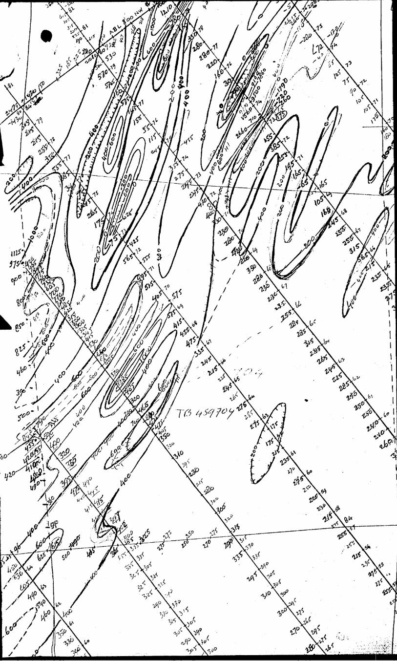
RESULTS AND CONCLUSIONS
The findings of the present survey confirm and reinforce the
conclusions reached after two previous radiometric surveys on claims
adjacent to the recently surveyed area (immediately to the east and
.immediately to the north, respectively). Reports on the older surveys
were submitted to the Ministry on 1977 12 20 and in March of this year.
In those reports, the author concluded that the likelihood
of encountering significant uranium- or thorium mineralization on this
property j y very low; that the local rock types are generally much more
sodic than potassic In composition, and that above-background readings
are to be expected only in drift-covered terrain and on transported
felsic boulders.
Nevertheless, radiometry may be considered useful not only
because it offers the remote possibility of detecting, or tracing, eco
nomically interesting mineralization, but also, and mainly, because it
caa bc an aid in establishing the nature and thickness of the overburden
which mantles much of the bedrock over a large portion of the surveyed
area.
It seems advisable, therefore, to extend the radiometric survey
over the 16 claims not yet traversed, and it. might be useful to perform
some additional reconnaissance in the source area of much of the over
burden: the Gzowski Lake Stock about 12 km to the northeast.
On some of the claims not yet investigated by radiometry, such
as TB 459700-1 and TJ5 464506, more-felsic volcanics and volcanic-derived
metasedimeiits were identified in the course of geological field work done
last fall and this summer. This area would be a logical target for the
next step in our continuing surveying program.
Ottawa, 1979 09 18
"f,/"
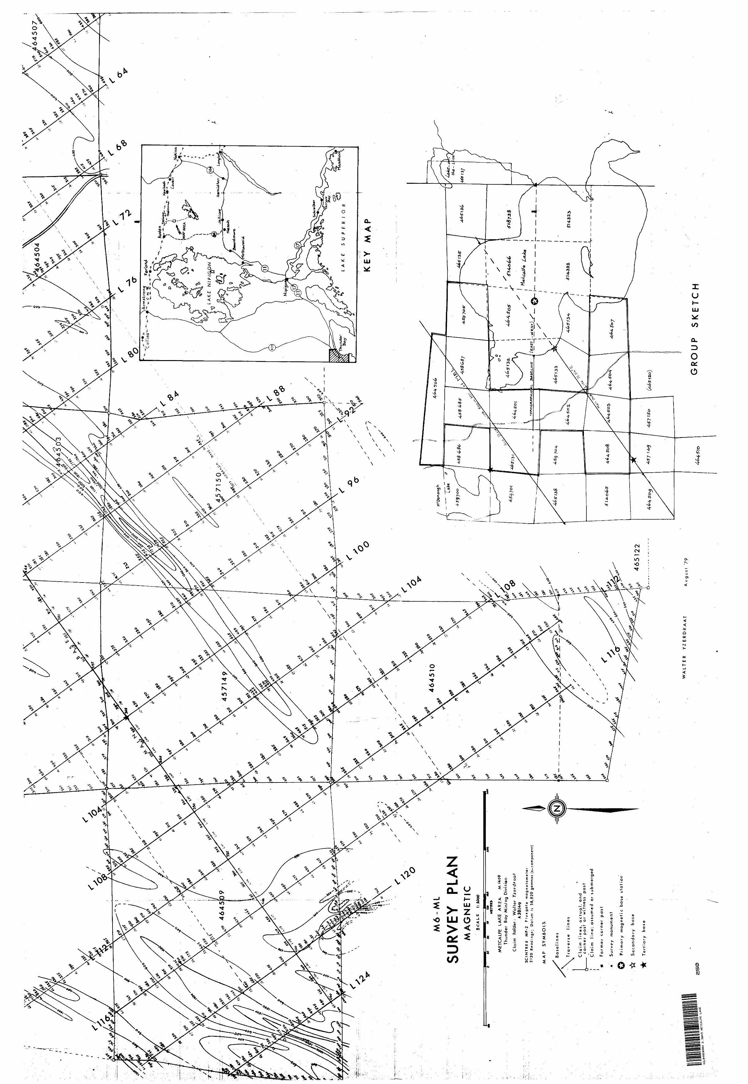
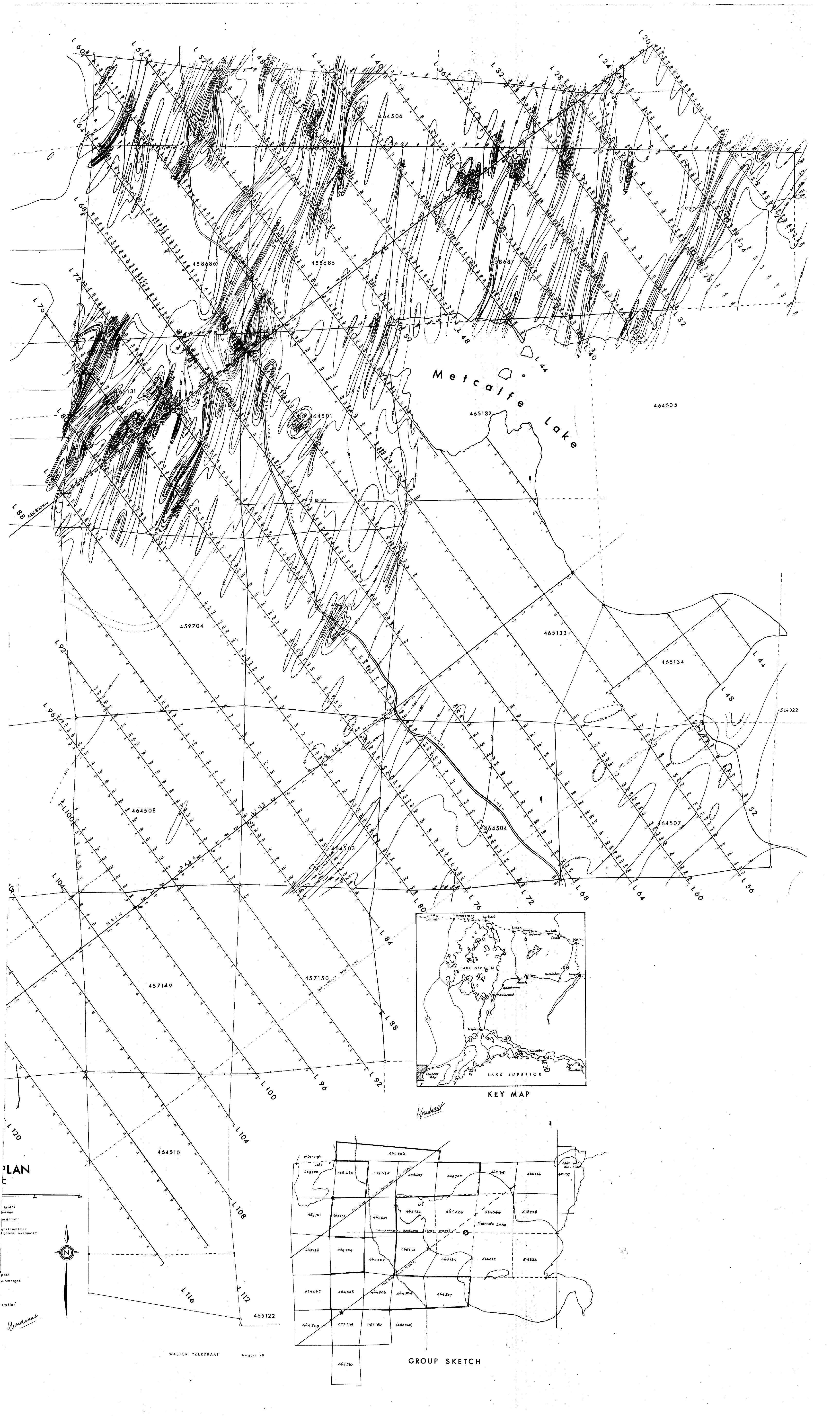
REPORT ON A MAGNETOMETER SURVEY
in the Metcalfe Lake Area
(Thunder Bay Mining Division)
by
S f P oWalter Yzerdraat ,, d Q
42LC4NE0203 2.3043 METCALFE LAKE 030
The claims to which this report rerers were surveyed oetween
October, 1977, and July 20, 1979. Ten of the eleven claims were mentioned
in a work report to the Thunder Bay Mining Recorder on. 1979 07 15; their
numbers are: TB 458685, 458687, 459705, 464501 to 464504, 464506, 464508,
and 465]31. One claim, TB 464507, surveyed after the 15th of July, 1979,
was reported separately on July 31, 1979.
All surveyed claims are part of a 32-claim group to which the
mining rights are held by the author of this report, and on which several
ground-magnetometer surveys were performed since February, 1976.
LOCATION AND ACCESS
The earlier magnetometer reports submitted by the same author
describe in some detail the various means of access to the. claim group,
which is situated some 8 km south of the CNR Transcontinental Line near
the former station of Tashota. This town is at mileage 177 west of Horne
payne and passenger trains do not stop there, but occasionally the traveller
can arrange a drop-off and pick-up with the despatcher at Hornepayne. The
Winter Road leading southeast and south from Tashota is not an easy one to
walk, and recently it has been left in an even worse condition by the use
of heavy machinery north and south of Gzowski Creek. Flying in from Nezah
or Nakina remains the most convenient, although not the least expensive,
method of reaching the grounds.
The claim group itself centres on a point at latitude 50 10' N,
longitude 87 0 39' W, and can be found on Mining Map M 1408. One claim (not
involved in the present survey) is in Oboshkegan (M 1413). The NTS map sheet
is 42 L/4.
GENERAL AND ECONOMIC GEOLOGY
For details about the regional geology and the economic
significance of the area, the reader may consult earlier reports by the
present author, as well as a number of GSC and OEM, ODM, OGS and OMNR
publications dealing with these topics.
Briefly, the Metcalfe Lake Area is a west-jutting salient of
a major greenstone belt which is part of the Wabigoon System. Copper,
silver and gold mineralization have been found in various parts of this
belt. As far as the Metcalfe Lake Area is concerned, the most important
finds are gold discoveries at Tashota Lake (north of Tashota), the Wascanna
property 2 km southeast of Tashota, the Adair property 4 km south of
Tashota, and the Tashota-Onaman Mine near the northwest shore of Onaman
Lake, some 25 ku south of Tashota. Minor gold mineralization was also
found at the Kipper-Lincoln property 4 km east of Tashota, and at the
Kipper-Cameron Hull Lake property some 3 km east of the claim group here
described.
Most of these discoveries date from the latter years of World
War I and the early twenties; little exploration was done in the late
twenties and during the thirties and forties. The relative decline of
the gold price (which was fixed, while all costs were rising) made further
work unattractive, and only in the mid-seventies there has been a revival
of interest in the Metcalfe Lake Area and its surroundings.
SURVEY AND GRID
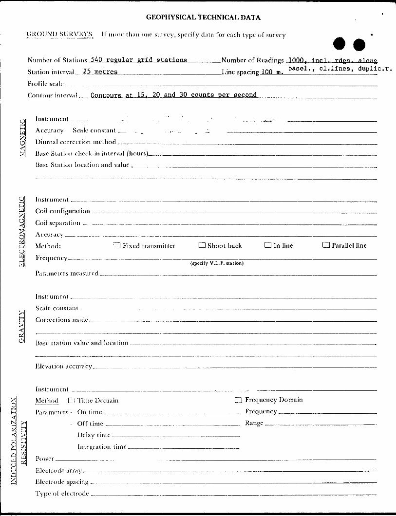
The work for this survey was done with a vertical-force fluxgate
magnetometer which had been used in earlier work on this property. Readings
were generally taken on grid lines at 12.5-metre intervals, although the
unit station interval is 25 metres. Where strong gradients were encountered,
some backtracking was done, and readings were repeated at quarter- or tenth
unit spacing. This enabled us to establish the maximum- or minimum inten
sities on a given line more accurately, and also to establish the profile
of any important: anomaly.
The grid itself was set up from a main baseline which cuts
across the widest part of Metcalfe Lake at an angle of 54 degrees with
the north-south direction as taken from the Nipigon Provincial Forest
Reserve Line, which is also the western boundary of the Township of
Oboshkegan. From this "Reserve Line", a topographical baseline (E-W)
was set up near the mouth of Metcalfe Creek. This work was done in the
winter of 1976; during the summer and fall of that year, both baselines
were extended into the grounds west and southwest of Metcalfe Lake.
The grid was continually expanded during the following years.
Wing lines were cut every 100 metres at right angles to the MBL. As the
station interval unit: is 25 metres, the lines were numbered in multiples
of the number 4, because they are four station intervals apart. The num
bering system resembles the geographical system in that line numbers
ascend from east to west, and station numbers from south to north. The
main baseline is at station 48 on each line; an important auxiliary baseline
cuts the grid lines at station 80, that is, at a distance of 800 metres in
a northwesterly direction from the MBL. Hence, it will be referred to as
the ABL 800 NW. The other ABL is that at 250 m to the SE of the MBL; it
was set up and cut in order to facilitate the extension of the grid across
the dry portion of claim TB 465134. The ABLs and the TBL have been used
for surveying as well as for control purposes.
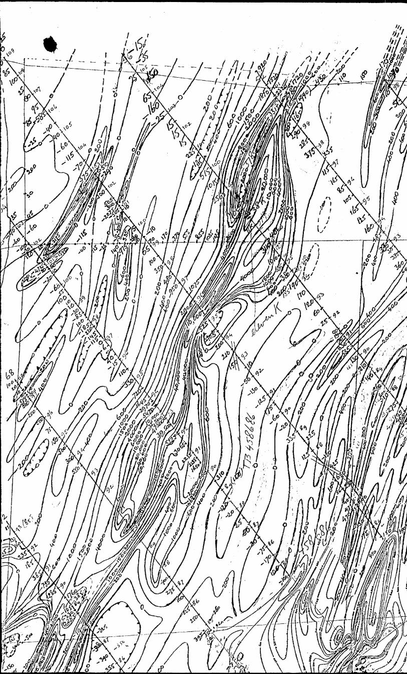
RESULTS AND CONCLUSIONS
On the northern claims it was possible to trace the extension
of some important anomalies identified earlier as horizons of iron formation
on claim TB 458686 (not covered in the present survey). A strong and per
sistent anomaly identified in the February 1976 survey on Metcalfe Lake could
be traced on claim TB 459705 where it cuts across survey lines 32, 28, 24 and
20, before crossing the north boundary of the claim group. The physical
nature of the body causing this anomaly has not yet been established with
certainty; in earlier reports it was speculated that it could be a mafic
dike. The same anomaly, labelled "A" in the May 10, 1976 report and sub
sequent reports, continues on the SW shore of Metcalfe Lake in a southwesterly

direction while gradually broadening and shallowing, indicating a greater
thickness of overburden as the terrain rises. In the present survey, it
has been established that the anomaly is continuous (on the 800-gamma level,
if not quite on the 1000-gamma level) across claims TB 464504, 464503,
457150, and 457149. On the latter claims, its existence had been established
in a survey conducted in February, 1978.
The southeastern and southwestern claims, TB 464507 and 464508,
respectively, show only gentle contour patterns, suggesting deep overburden,
and not indicating any important, consistently-trending magnetic bodies at
bedrock level.
Unfortunately, due to time limitations and the difficulty of
securing help in the linecutting, the westernmost claims of the group, viz.
TB 465138, 514065, 464509 and 464510, had to be left out of the present
stage of the project. Their magnetic exploration should round out the
picture so far obtained.
Another area where work is considered in the near future, is
the northeastern quadrant of the claim group. Consideration is also being
given to a VLF-KM survey to complement the magnetic data now collected and
plotted.
OTTAWA, 1979 09 18
tano
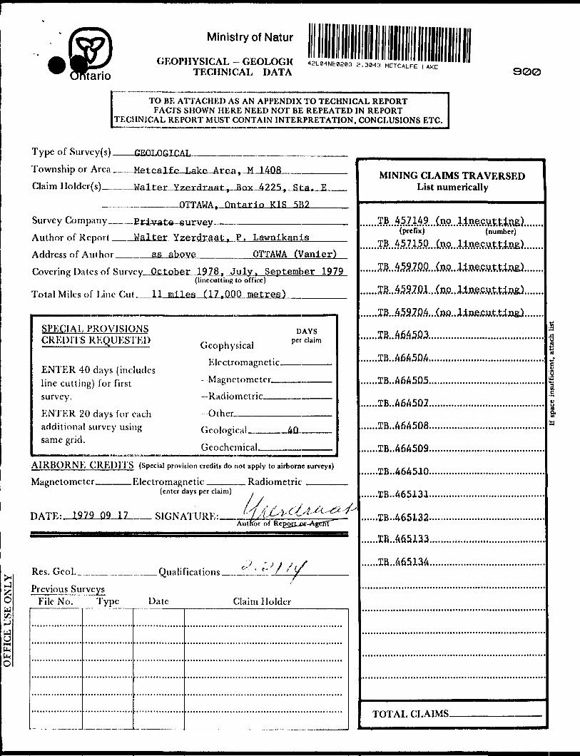
Ministry of Natur
GEOPHYSICAL - GEOLOGIC TECHNICAL DATA
42L04NE0203 2.3013 METCALFE LAKE
300
E TO BE ATTACHED AS AN APPENDIX TO TECHNICAL REPORT FACTS SHOWN HERE NEED NOT BE REPEATED IN REPORT
:CHNICAL REPORT MUST CONTAIN INTERPRETATION, CONCLUSIONS ETC.
Type of Survey(s) .
Township or Area Metcalfe
Claim Holdcr(s) W*
Arfta, M UOR
rdraat, Box 4225, Sta. E
QTTAWA, Ontario K1S 5B2
- E'rivate surveySurvey Company -
Author of Report __Walter Yzerdraat, P. Lawnikanis___
Address of Author ____as above_______OTTAWA (Vanier)
Covering Dates of Survcy,J3ctQber 1978, July, September 1979(linecutting to office)
Total Miles of Line Cut- miles (17,000 metres)
SPECIAL PROVISIONS CREDITS REQUESTED
ENTER 40 days (includes line cutting) for first survey.
ENTER 20 days for each additional survey using same grid.
Geophysical
Electromagnetic.
-Magnetometer .
DAYS per claim
Other.
AIRBORNE CREDITS (Special provision credits do not apply to airborne surveys)
Magnetometer. .Electromagnetic. .Radiometric
DATE: 1979 09 17
(enter days per claim)
SIGNATURE:.Autnor of
Res. Geol. _^______
Previous Surveys File No. Type
. Qualifications _.-JL-ULl.
Date Claim Holder
MINING CLAIMS TRAVERSED List numerically
(prefix) (number)
.TB...4.537.Q.Q...(jJ.9...Ua?.W.t.Ua8J.
.TB...45970.4...(wj..
JB...46.4503..........
.IB...46A50A.,
.IB..A6A505,
.TB..A6A502.
.IB..A6A5D8.
.1B..A6A509.
.TB..A6A510.
..IB..A65131.
..IB..465133.
..TR..A6513A.
TOTAL CLAIMS-

IND
UC
ED P
OLA
RIZ
ATI
ON
- R
ESIS
TIV
ITY
GR
AV
ITY
ELEC
TRO
MA
GN
ETIC
MA
GN
ETIC
H *^ r? Q O cT
o -
~. n.
C
3•5 1 (
— * D 3^
T f: 2.
v...4 -i -~
-
^*
!5j
1
g
Q~ O 5 r-. 3 o
S ~ *. 3
c0 — .
1~t
Ir i; "Q
*" 0
i 1 ** -i T' n
D H
H 5
— .
rs3
t; w s- Do
rt2
, oc.
c1
O
0
0<
X O o 3 5'
rs
~
-j 2 o ~
fi ^- o -J. - ^- ~^ 5 s
fs
^ EL o
Scale
constann -i 2
Parameters
m /i 2 i
, _ •S S. 2 5' 3
Method:
Frcniicncv
U T; x' cL f~^ si 3 1.
0 a C/3 sr c Q O" fs o TT D 3* 5" rt n o" 5' o
Accuracv-
,..-p S Ei
a3
n 0 o ^\ IT?i'
- a: 5
Instrument
/i rf
^ r^.
~ '
K EL - 15
WrW ^
r/j O C
rO
0 D 5T"
-U -5 1 -—
D- r on w^
Diurnal
corre o n 3 O r* a.
T ^ 0
-^ 1 O n iT 3
Instrument
.? -l r; i
o a;
t- CCfl
O
•~*,
^ . 5' o Vi 3 5' q
0z "c^
C
! ~3
^0CT
; '
~l
2 2
— i i r*^
- i ~
i :^
rj~- *"
^l "^
* - — j 3 — -j' - o 5 0'
.; s
s O
P "*
^
5 E2c
O2
i**T
^ IT
*
ST
P5z
G
r f I
3
O
*xcr
3-
~
2.
-O
o 3
^
^
o H
73
O"
1*
1 s
Q 0
f
^
^ ^BV
Ontario
Ministry of Natural Resources
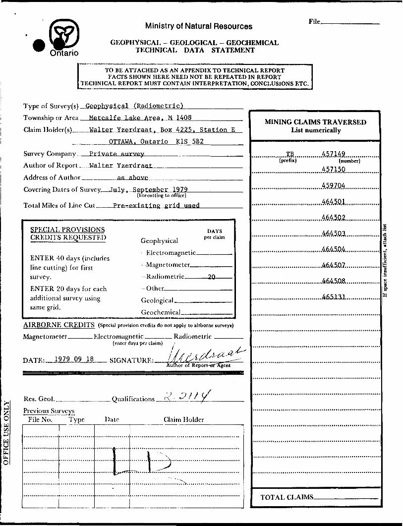
GEOPHYSICAL - GEOLOGICAL - GEOCHEMICAL TECHNICAL DATA STATEMENT
File.
E TO BE ATTACHED AS AN APPENDIX TO TECHNICAL REPORT FACTS SHOWN HERE NEED NOT BE REPEATED IN REPORT
ECHNjCAL REPORT MUST CONTAIN INTERPRETATION, CONCLUSIONS ETC.
Type of Survey(s) Geophysical (Radiometric^,Township or Area _Metcalfe Lake Area, H 1408
Claim Holder(s)___Walter Yzerdraat, Box 4225, Station E
_______OTTAWA. Ontario K1S 5B2—^-——
Survey Company__Private survey————————^^-^^———
Author of Report __Walter Yzerdraat
Address of Author _______as above
Covering Dates of Survey July, September 1979(Imecutting to office)
Total Miles of Line Cut. Pre-existing grid used
SPECIAL PROVISIONS CREDITS REQUESTED
ENTER 40 days (includes line cutting) for first survey.ENTER 20 days for each additional survey using same grid.
Geophysical--Electromagnetic.-Magnetometer—-Radiometric——
Other.——-———
DAYSper claim
Geological.Geochemical.
AIRBORNE CREDITS (Special provision credits do not apply to airborne surveys)
Magnetometer. .Electromagnetic . Radiometric(enter days per claim)
DATE: 1979 09 IS__ SIGNATURE:Author of Report--cir"Agent
Res. Geol... . Qualifications ^l^.^
Previous Surveys File No. Type Date Claim Holder
MINING CLAIMS TRAVERSED List numerically
(prefix) (number)
.A57.W.9..........
..4M5.C&.................
.A6M0.3..................
..4.6A5.0.4...............
..4.6.4^.0.7..
TOTAL- CLAIMS-
IND
UCE
D P
OLA
RIZA
TIO
N-
RES
ISTI
VIT
YG
RA
VIT
YEL
ECTR
OM
AG
NET
ICM
AG
NET
IC
1 1 — ;
ra ra"
ra "
3 ra"
3— *
k
~ -) r
™t *
•i ^ - -^ — *
^-r-
1 — :L "i
s*
™-^ *5 — - "^
w jl,
^ I"
QD -k 3 a 3
rq o
Method [
PH
t'H meters t i
t
O
—;3
3'
^.
C•^
t"
1ra
^-v 1" D
? ~?
ra ra
O
.Q
C
C
ra
ra D
3
ra
ra<
^ O o 3 3"
— * i? /3 ? ™ •* i
V,o l; "i n ^ ^ ^
b^
J
fi as x "5 (S ^•
E.
P
T ^
^ 3 r^
0 ~
3 yi .^ 2
3 "
ra •j 3 g "™5
•o rt "^ 51 ^J ft o' 3
l |
2 E-
^
D T x' n Cu ^ S C/5 3. r-*
O
-t D r** y o 0 O"
as o D 3* 5' n S? •1 p* , ?r 5* o
•j o <
n s* 2 2^
i"* 5
0 O n 0 q'
^ ^•4
^
Instrument
6J s ra as — -
as D.
i: ra
'Base
Static)
-* ~ ra TT 3 ? ^ — - v
ST-
O ~ ^"
3 ra ra n Q "^ ra Q.
'
Instrument
Accuracy - en ra ra" ra H
- S 3
t
1
r
' . - i i
Contour
inter s. r-j
g rt 0 C If M
, rt i-i
^ S 1 O 0 O 3 rt CO d fD
H CO
(D
0 o CU
•-5*
1 — )
ra"
w; EL
*i tStation
intcrv ~ NJ
1 rt if CO
l l
-* ^ en O as D.
3 q .hj
D 3 c
cr pj co (D " O M B H-
H-
3 (D
(CO 0,
C M H-i
O
^ i 5
Z3
i'c3"
r"
5
:2
O
:' t?
J 2
J'.
;x;
' K
Ln
^
0 1 f
to —
"i ?T
't z
S
ra g
ft i
^33
ra S
2 1
g0.
^"
C-"'
ci
B^
* ^
^
^
M
o1
2Z
ra
0•3
r^ ta4
3- sr
r*
3. 1
1
?0
C ^
re —
i a
rj,^
r-
l
\
—t
O 0 o 3 ^ -1 f Jfl
^o.
^
B19
^^^ •
B D 3 *
X5

Instrument_____________________________________________ Range.
Survey Method _____________________-—————————^—-——..——————-
( Corrections made.
RAJ))OM1,TRK:
Instrument Scintrex BGS-lS broadband gaimiaray spectrometerValues measured Counts per second^^,^^^^
Energy windows (levels) Energy threshold 80 KeV
Height of instrument Placed on rock or overburden______Background Count 3-5 cps
Size of detector___l" x l" sodium -[ndi'tip. crystal_____________________^_________
Overburden___ZPTO to 86Wr^1 metres — pp-ft Report of todays' date — organic and silt/pebbles(type, depth — include outcrop map)
OTIJKRS (Sl'.ISM 1C, DRILL WKI.L LOCiGINC; 1:'IC.)
Type of survey__ _____________ ————-——————————-—————————.—-^—^—————^——^————J r J ' '
Instrument______,.________-__—___._.-—^-—----.-.-—.—.—.---——.———.-—^-^,-—..—————..—-—.——.
Accuracy ____________________________________________________________________
Parameters measured.________________——————-—^^^-——-^——^-————————————.—...—.—
Additional information (for understanding results) —
A1MQHNK SURV1 'A'.S
Type of survey(s)___.
Instrumcnt(s) _____(specify for each type of survey)
Accu racy-.—..—--.—-—-——^^—.-——(specify for each type of survey)
Aircraft used —-————^-————-—.-———-...-—-..-.—-...—-....——.——.
Sensor altitude-—-.-—.——-———-——————
Navigation and flight path recovery method —.
Aircraft altitude_________________________________Line Spacing
Miles flown over total area___________________________Over claims only.
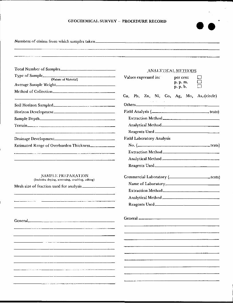
GEOCHEMICAL SURVEY - PROCEDURE RECORD
Numbers of claims from which samples taken.
Total Number of Samples. Type of Sample.
(Nature of Material)
Average Sample Weight.——-———-
Method of Collection———————.
Soil Horizon Sampled.
Horizon Development.
Sample Depth———^.
Terrain————————
Drainage Development.———————————
Estimated Range of Overburden Thickness.
.ANALYTICALNIEJIIQDS
Values expressed in: per cent p.p. m. p.p. b.
n aa
Cu, Pb,
Others—
Zn, Ni, Co, Ag, Mo, As,-{circle)
Field Analysis (.
Extraction Method.
Analytical Method-
Reagents Used-——
Field Laboratory Analysis
No. ———————————
SAMl'lJU'RKl'ARA'JlON(Includes drying, screening, crushing, ashing)
Mesh size of fraction used for analysis ————.
Extraction Method.
Analytical Method .
Reagents Used ^—
Commercial Laboratory {_
Name of Laboratory——
Extraction Method-
Analytical Method ——
Reagents Used ———
.tests)
.tests)
-tests)
General. General.
tario
Ministry of Natural Resources
GEOPHYSICAL - GEOLOGICAL - GEOCHEMICAL TECHNICAL DATA STATEMENT
File.
l TO BE ATTACHED AS AN APPENDIX TO TECHNICAL REPORTFACTS SHOWN HERE NEED NOT BE REPEATED IN REPORT
[TECHNICAL REPORT MUST CONTAIN INTERPRETATION, CONCLUSIONS ETC.
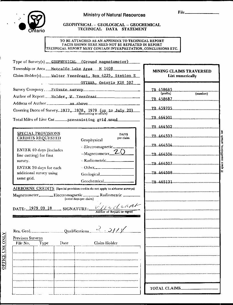
GEOPHYSICAL (Ground magnetometer')
etcalfe Lake Area M 1408—————
Type of Survey(s)
Township or Area
Claim Holder(s)___Walter Yzerdraat, Box 4225. Station E
OTTAWA, Ontario K1S 5B2
Survey Company__Private survey
Author of Report _Holder.,—W..
Address of Author ________aa ahnvp.
Covering Dates of Survey, 1977, 1978, 1979 (up to July 20)(linecutting to office)
Total Miles of Line Cut. grid used
SPECIAL PROVISIONS CREDITS REQUESTED
ENTER 40 days (includes line cutting) for first survey.
ENTER 20 days for each additional survey using same grid.
Geophysical
-Electromagnetic
—Magnetometer_
—Radiometric__
-Other..——————
DAYSper claim
Geological.
Geochemical.
AIRBORNE CREDITS (Special provision credits do not apply to airborne surveys)
Magnetometer. .Electromagnetic. . Radiometric(enter days per claim)
HATK- 1979 09 18 SIGNATURE:.Author of Report "
Res. Geo!.___ . Qualifications __'^_- 3 f f ,K
Previous Surveys File No. Type Date Claim Holder
MINING CLAIMS TRAVERSED List numerically
(prefix) (number)
.....TB..4645Q3.
.....XB..4645Q4.
.....TB..4645Q6.
......XB..464507.
......EB..464508.
TOTAL CLAIMS.
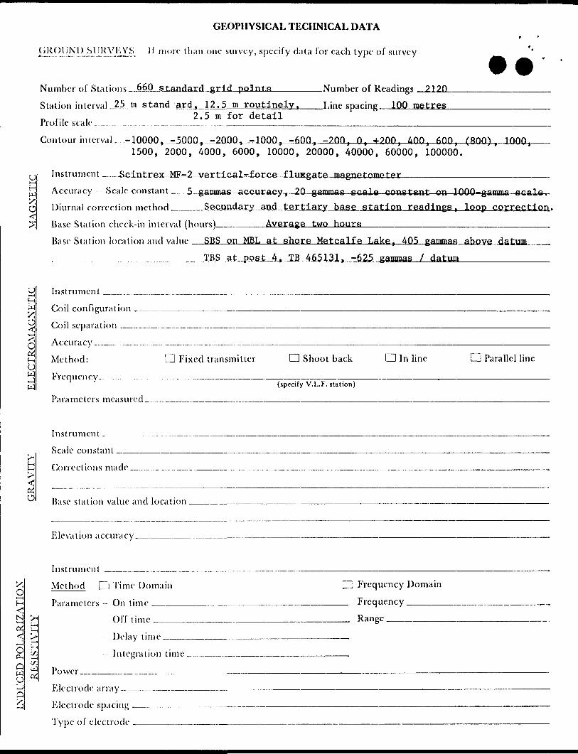
GEOPHYSICAL TECHNICAL DATA
SUKVKYS 11 more that) one survey, specify data for each type of survey
Number of Stations 660 standard grid points_______Number of Readings 219.Q
Station interval .J?5.jn .stand ard, 12.5 m routinely, Line sparing 100 metresr, .., 2.5 m for detailPro! i le sea le....... ......... ., ^ ^..——..—,—--—.—^——.—.—.-..^-.^—..———.————-^—^
Contour interval-^.-J.0000,^-5000-,—-.2000^-^0000^^600, -200, O, 4-200, 400, 600, (800), 1000, 1500, 2000, 4000, 6000, 10000, 20000, 40000, 60000, 100000.
Instrument — ._Scintrex MF-2 vertical-force flviggate magnetometer_________________
W 'S,
O <tr-f ^
O c* f-ib wj w
Oi
OH
N*-4
rt . .Delay time
Accuracy Scale constant ——5-gammas; -accuracy, 20 gammas scale constant on IQOQ-gamma p Diurnal correction method ____Secondary and tertiary base station readings , loop correction.
Base Station check-in interval (hours)_______Average two hours____.—______________________Base Station location and value _SBS on MSL at shore Metcalfe Lake, 405 gammas above datum ^________ ^________IBS at post 4, TB 465131, -625 gammas l datum_________
Instrument ___ ...^_..,..__,..__._____. ^.^^^^^^.^____^_^^_^________^________________H
Coil configuration _____________..—————-———-———-———-——.—-———-———-.^—^^^————..—.-—.—.
Coil separation ,_..., .—.-.-.... ....._......_...____________________________________________
Accuracy -._- . —....... .^.. __..--.—.-......__..___.—-^^—^-^———-—^^--——--——-———————————-.
Method: Q Fixed transmitter Q Shoot back d In line CD Parallel line
Freq u en cy __..... ....... _ ...^ .___-....__-——{specify V.L.F. station)
Parameters measured
Instrument ^ _
Scale constant -..—
Corrections made..
Base station value and location
Elevation accuracy.____.__.__.____.-^—-
Instrument __^^__..________________.——.———————————————————————
Method D Time Domain CD Frequency Domain
Parameters- Or) time___________...________________ Frequency ————.
Of f time___________.________________ Range ————————
- Integration time______—-
[i3 ^ Power__. U
Electrode array——
Electrode spacing ,
Type of electrode
NOTES
40O* surface rights reservation along the shores of all lakes and rivers.
87 45 44
Deacon Site -"-^ Defrt of Transport GZOWSKI /v;
f .1J lFOR STATUS REFER TO504539 1(500359
! U Jl———————t ————— h- ————|J^3*
504537 p--—k----L.— .4 ™-—,
-4 ,. '49637 '4 ,l —— ——,—— — J. J-
— L,-..iL._ J _ -— — l l- — V TB l ,. l ~~ - — - ——
/496359J 4*8358
OBOSHKEGANFOR STATUS REFER TO TWP^^PLAN 1413
, M6628 /| 5I662S , 5166Z2 |
1 j 1, i A~x^i -f
l 471474 47,477-TB
47I4SI 47I486 1 471487' 471492 47J47J}!______ '.---J. — —— J- — — -J
TB , TB
47LT4 |72' 471479 l 471480 l l
814066 \5i872B
~~~ ~~~~~ ~~~"
-* w-j 11 v I-TWIIJ Or Q*J r O
r-- - i- --i-l TB TB TBi 515673 515674 , 515675
.5259221 t- - - -
TB i(525925) 525984
--T---
—---^---;~ —
1472411 l 472410
472255)472256L----L___J
50 07 30-1
6745 44 40l/
39 37 36l ,
35 34 33 32 31 87 30
R F F F R E N C fi S
Tp P O C-, R A P H Y
LAK!-" V -'v-rk', iTr -no 1 : rjf^F INVI l . ' io' sni i: r N . 502873
SURVEYS
C.N.R. BY W.J.MOORE O.L.S ,APRIL IST.I9I6. PLANNO.M2-27 AND M-2-23
BASE LINE BY SPEIGHT AND VAN NOSTRAND O. L. S. 1925 BOOK NO. 2564
MERIDIAN LINE SURVEYED BY PHILLIPS AND BENNER O. L. S. 1916. BOOK NO. 2474
CONTROL TRAVERSE BY R S KIRKUP O.L.S. 1942 PLAN No. P 15-18.
DATE Of, ISSUE
JAN l 51960
SURVEYS AND MAPPING
DISPOSITION OF CROWN LANDS
TYPE OF DOCUMENT
PATENT, SURFACE 4 MINING RIGHTS
, SURFACE RIGHTS ONLY..,.., MINING RIGHTS ONLY .....^
LEASE, SURFACE A MINING RIGHTS..
" , SURFACE RIGHTSONLY.^....
" , MINING RIGHTSONLY.-.,...,
LICENCE OF OCCUPATION -—.......
ORDER-IN-COUNCILRESERVATION ..,-———--.———-~
CANCELLED __ ,———.__
SAND 81 GRAVEL ._.. — -——........
SYMBOL
NOTE: MINING RIGHTS IN PARCELS PATENTED PRIOR TO MAY 6. 1913 VESTED IN ORIGINAL PATENTEE BY THE PUBLIC LANDS ACT. R.S.O. 1970, CHAP. 380. SEC. 63, SUBS6C 1.
TRAVERSE: POST M-23
O N TAR l Q
API A
METCALFE LAKEDISTRICT OF
THUNDER BAYMINING DIVISION JDF
THUNDER BAYAA.L ' ** t-.J -D. | w '-'-EJD. IMAR.25. 1954
' ,NCH 40 ' HS
TORONTO, CANADA M-140842L84NE0203 2.3843 METCALFE LAKE 200

"r -
' -. ; , r0 -'. ' - --.. r .'.•Vf^^
•VH
f
464*06
No outcrop
459700
(9 ')L l J li
465131
465132Cecfa-r. Al^er
N.O.
4645Of
Outwash plain
465/38 464502459704 465133
464508514065 464503 464504
fbwash plainCoblesSi/t
Silt
Pebbles d \0*/.
464509 45-714*5
KEY MAP
No outcrop
No outcrop l
— ..D Old" '
No oubc-ropMo outcrop
GROUP SKETCHWALTER YZERDRAAT
42Le4NE0203 2.3043 METCALFE LAKE 210
in HP.*.. —,-,.,42LC4NE82IS3 2.3043 METCALFE LAKE 220
4645O6
459700
0 465131
465132Cedar. Alder SWa
N.O.464501
45-9701
Alder swamp
465 JS3459704 464502
465133
PebWcs S-10% x- Esker
Pebble* <5% A6A5O8514065
Outwash
Pebbles- toy.
Pebbles ci \o*L
Ot;twasli
457150
KEY MAP
464510
GROllWALTER YZERDRAAT August 7 9
SKETCH
58687
459700
459701
46513
514065
464504
LAKE SUPERIOR
KEY MAP
R3-MLSURVEY PLAN
RADIOMETRIC
/AETCALFE LAKE AREA M 1408 Thunder Bay Mining Division
Claim hofder .- Walter Yzerdroat A 36149
Claim lines, actual, and corner post or witness post
Claim tine; assumed or submerged
Former corner post
Survey monument
Primary magnetic base station
Secondary base
Tertiary base465122
WALTER YZERDRAAT
GROUP SKETCH
:-'"V'- III Illinium.....,.,;; :;'-i '' 42Uei4NEa203 2.3*43 METCALFE LAKE
459700
e t
l __ ,
459701
514065
4.64504
LAKE NIPIG.ON
S U P E R .f O R
KEY MAP
M6-ML
SURVEY PLANMAGNETIC
/AETCALfE LAKE AREA MHOS Thunder Bay Mining Division
Claim holder: WoJfer
SCINTREX M F-2 Fluxgats magnetometomer2120 Readings- Datum is 58,900 gammas z-component
J (EAST , - w EST ) X - - - - - —
MAP SYMBOLS
Basel i nes
Claim lines, actual, and corner post or witness post
Claim line; assumed or submerged
•9 Former corner post
Survey monument
Primary magnetic base station
Secondary base
Tertiary base
465122
WALTER YZERDRAAT
GROUP SKETCH
.,..,....3843 METCALFE LAKE
46
45
07
^••
•4.6
4504
{MAP
AREA
\
46450
SU
PE
R/O
R
KE
Y
MA
P
M6-M
L
SUR
VEY
PLAN
MA
GN
ET
IC
/AE
TCA
LFE
LA
KE
A
RE
A
MH
OS
T
hunder
Bay
Min
ing D
ivis
ion
Cla
im
ho
lde
r:
Walter
A38H
9
SC
INT
RE
X
M P
-2
Flu
xg
ate
m
agneto
mete
r2
12
0
Readin
gs;
Datu
m
is
58,8
20 g
amm
as (
z-co
mp
on
en
t)
MA
P
SY
MB
OL
S
Basel
i n e
s
Tra
vers
e
lin
es
Cla
im
line
s,
actu
al,
an
d
corn
er
po
st
or
witn
ess
post
' C
laim
lin
e;
ass
um
ed
or
su
bm
erg
ed
•p
Fo
rme
r corn
er
post
Surv
ey
mo
nu
me
nt
Prim
ary
m
ag
ne
tic
base
sta
tio
n
Se
co
nd
ary
base
Tert
iary
b
ase
46
51
22
WA
LT
E R
Y
ZE
RD
RA
AT
Au
gu
st
79
SS
0G
RO
UP
S
KE
TC
H

o
46*306
464505
SURVEY PLAN G 2-MLGEOLOGICAL465131
METCALFE LAKE AREASCALE 1:2000465J32
Cedar. Alder 464501100 7S METRES
Field work; October, K);8 -Jul//September, 1979
Recorded holder; Walter Yzerdraat,
LlTHOLOCilCAL UNITS
L lafce Archean. Proterozoic 10 t&fri 1 Mafic intrusions All sediments are .schistose.
mineralogy fsls appear i n10a Porphyritic^ sericitized phcno-
crysts af-tar alettePorphyritic; clinopyroxene Phenocryst^ in rfch matrix
eh chert (y)Arg . . ,. ^^ IF Iron Formation~~'
H. ArcheanA. METASEDIMtNTS
Arkose- argyl li te
t hornblende PXu chlorite SilV magnebibeTcxbure txnd. structure
X,- A --Mafic-derived
B. PLUTONSbnd banded., bandingg bel graded beddingx bd cross b edd i(f.) lam (finely)rel refi'ctrew reworkedSer 5e.Cidtiz.eA
SYMBOLS- inferred/obscrvecl
Outcrop; rock type
C. HETAVOLCANICS
Rhyolite; 5^ tuff Rhyodacibe; 4a tuff Dacite 5 3*. Tuff
Outwash p' flin
Top direction, pillow* StriKt arui clip ,Mafic types
la Fallowed. i b Flows t ( ,. le Concordant an/illowiintrusions
(d) sub-porpKynbtc.-.,-i--,,-i j vesicular
\" Bedding sbrikeartd
Small oufcropPebble^
5iiki it-
Pebbles
464502.459704 465133Forest Cover
Silt Pebbles <5'%
Outwash46S134
Esker
Febtles <5%
-10% pebbles Silf
Outwash
pebbles os
Z64508464503 4645074645O4
S-10% pebbles Silt
Silt
er-10% pebbles
Outwashilt, febbles
Silt
Pebbles ci \0*/.
Qu^wqsh plain
Outwash4^7150
45-714^
KEY MAP
— . - —P-- \
No oubcrop
GROUP SKETCHWALTER YZERDRAAT

464-5O6
V'
\\
\
458687 459705-
^
M O
465132
r \
xX1b
OUTCROP MAPFOR
July '79 Radiometric Survey
R3-ML
ROCK TYPES
1 Mafic and intermediafe volcanics
1 a PillowedV
1 b Schistose, flows (d Sub-isorpUyritic) (C AmygdAloMftl, vesicular^
2 Felsic volcanics
Mafic intrusion*
Ald er- 459704 464502\ 4
465133
\
Out washo Pebbles
46SJ34Esker
Silt c?
Sift
o SJ/t
Pebt/csPebblts ^ 5
Esker
Esker
s;/t a c layPebbles 6'-^0%
Outwash
464508
*2 iO 0/.'Pebbles
V Silt Silt
464S04Pebbles c*
464507
Silt
Si/t* Clay
Pebb/es
PebblesEsker
Silt
febblesPctbles <5%
Pebbles
bles
CobblesPebbles
PebUcs V^
Pebbles cs io;
Outwash
' JD CT
a 0s(J
O KEY MAP
7 M, c PonoLi^h
WALTER YZERDRAAT A o g u s i 79
SKETCH
464505
464504
SCINTREX BGS-IS July-September 1979540 grid points, 999 readings
LAKt S U P E R ; O fi
KEY MAP
465122
WALTER YZ ERDRAAT
GROUP SKETCH
464507'464504
SUPERIOR
464510
[g n elomeHm e r gammas z-component
D----- - -- - - - - -
WALTER YZERDRAAT
GROUP SKETCH