Embed Size (px)
Citation preview
Ohio Department of Natural ResourcesDivision of Watercraft
watercraft.ohiodnr.govRevised 5/2013
Western Ohio Streams AccessG
reat
Mia
mi R
ive
r
!!!
!
!!!!!
!!!!!
!!
!
!!
!!!!!
!-
Caesar Creek Lake
Buck
C
re
ek
Indian Lake
Clarence J BrownReservoir
Kiser Lake
Mad River
98 7
6
4
3
2 1
3231
3029 28
2723
21 20
1918
17
16
15
1413
12
10
26
67
47
560
54
508
245
119
274
235
65
29
201
571
589
72
287
55
380
117
725
814
706
296
343
41
540
273
366
638
444
73
507
48
195
734
370
794
835
292
365
72
29
235
235
235
41
589
117
47
£35
£36
£33
£42
£68
£40
§̈¦75
§̈¦75
§̈¦70
§̈¦71
§̈¦675
5
11
25 24
22CLARK
GREENE
MONTGOMERY
MIAMI
CHAMPAIGN
LOGANSHELBY
AUGLAIZEHARDIN
Dayton
Sidney
Xenia
Springfield
Urbana
Bellefontaine
Piqua
Enon
Waynesville
Quincy
Anna
Botkins
New Carlisle
Cedarville
Degraff
Jamestown
Jackson Center
West Liberty
Lakeview
Valley Hi
Saint Paris
Russells Point
Rushsylvania
Belle Center
Huntsville
South Charleston
Clifton
Spring Valley
North Hampton
Christiansburg
Bowersville
Port Jefferson
Lawrenceville
2 0 2 4 61 Mi.
Mad River
Legend
River
Scenic River
Watertrail
Access Point
Hazard
Dam
State Route
U.S. Route
Interstate
City
Parking Lot
Roadside Parking
ADA Accessible
Launch Ramp
Camping
Bike Trail
Food
Picnic
Restrooms
Drinking Water
Canoe Rental
North
ID Description Lat/Long Amenities
1U.S. Hwy. 68 bridge in West Liberty, roadside access river left with permission
40.24907-83.75536
2Pimtown Rd. bridge, roadside access river right
40.24344-83.76456
3Upper Valley Pike (Sullivan Rd./Mennonite Church Rd.), roadside access river left
40.22272-83.77287
4Lippincott Rd. bridge, access river right
40.19464-83.79678
5DAM—(farm road through river), approach with caution, portage on either side
40.17300-83.79572
6St. Rt. 296 access just upstream of St. Rt. 29 bridge northwest of Urbana, roadside access river left
40.15645-83.78683
7St. Rt. 29 bridge northwest of Urbana, roadside access river left
40.15510-83.78820
8
Birch Bark Canoe Livery Ltd. (1455 River Rd., Urbana, OH 43078, 937-652-2663) just north of Millerstown Rd. on River Rd. northwest of Urbana, access river right with permission
40.13180-83.80978
9Millerstown Rd. bridge and River Rd. northwest of Urbana, access river right
40.12992-83.80975
10North of U.S. Hwy. 36 bridge west of Urbana, access river right
40.10747-83.79931
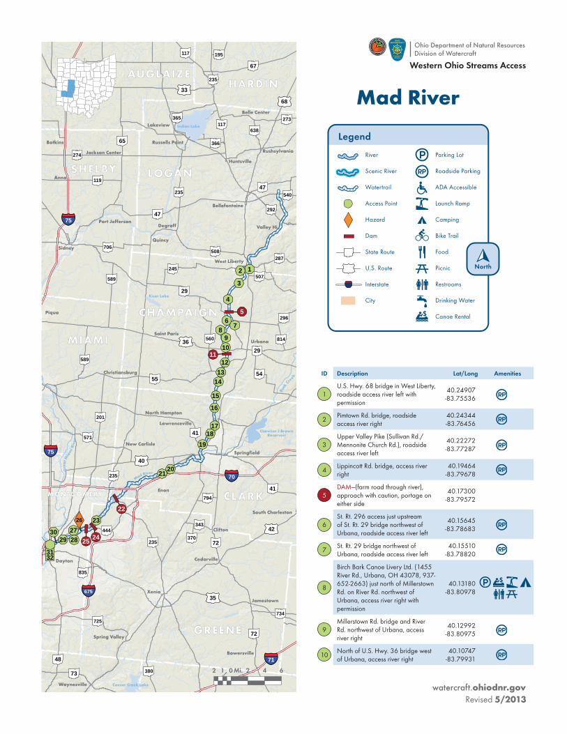
Ohio Department of Natural ResourcesDivision of Watercraft
watercraft.ohiodnr.govRevised 5/2013
Western Ohio Streams Access
27Eastwood Metropark on Harshman Rd. in Dayton, access river right
39.78532-84.13107
28
RAPIDS—small rapids in Eastwood Metropark, sometimes used as kayak play area, portage river right or left if necessary
39.78244-84.13801
29Findlay St. bridge in Dayton, access river left
39.77443-84.16118
30
Valley St. access (Whitewater Warehouse) in Dayton, upstream from Keowee St. bridge, access river right
39.76946-84.17519
31Webster Street bridge in downtown Dayton, access river right
39.76865-84.18367
32
Deeds Park (Dayton Park District), Mad River and Great Miami River confluence in downtown Dayton, access river right
39.76722-84.18733
ID Description Lat/Long Amenities
11DAM—2-3 feet, just downstream from U.S. Hwy. 36 bridge, portage river right
40.10680-83.79915
12Old Troy Pike bridge, roadside access river right
40.08587-83.80141
13St. Rt. 55 bridge southwest of Urbana, access river right
40.06850-83.81040
14Dallas Rd. bridge, roadside access river right
40.05279-83.81522
15County Line Rd. bridge north of Tremont City, roadside access river left
40.02818-83.82104
16Tremont City Rd. bridge east of Tremont City, roadside access river left
40.00740-83.82312
17Eagle City Rd. bridge east of Eagle City, access river left
39.97638-83.82178
18St. Paris Pike bridge south of Eagle City, steep access river left
39.96395-83.83155
19
St. Rt. 41 (First St.) bridge west of Springfield, Mad River Canoe Rental, (937-325-0115 for details), access river left below bridge
39.94376-83.84908
20
Aaron's Canoe & Kayak Center (5605 Old Lower Valley Pike, Springfield, OH 45502, 937-882-6925), access river right with permission
39.90029-83.92005
21 Enon Rd. bridge, access river left39.89159
-83.93530
22DAM—approximately 1/2 mile downstream of Osborn Rd. bridge, portage river right
39.84632-84.04373
23
Huffman MetroPark (Montgomery County Parks), north road (HR2) into MetroPark to parking lot at end, last easy takeout before dam, access river right
39.80697-84.08723
24
DAM—73-foot Huffman Dam in Huffman Reserve MetroPark (Montgomery County Parks) in Fairborn (Miami Conservancy Flood Dam), difficult portage river right
39.79735-84.09040
25
DAM—8-10 ft. on right side of river, DO NOT continue on river, leads to another dam and a dangerous spillway with a 4-5 ft. drop into a hydraulic, stay far left and takeout on left side of dam
39.79326-84.10015
26
HAZARD—large pipe across river approximately 0.7 miles downstream of previous dam, portage river left or right with caution
39.79315-84.11563
ID Description Lat/Long Amenities
Mad River(continued)