Embed Size (px)
Citation preview
Paull, C.K., Matsumoto, R., Wallace, P.J., and Dillon, W.P. (Eds.), 2000Proceedings of the Ocean Drilling Program, Scientific Results, Vol. 164
26. SEISMIC AND THERMAL INVESTIGATIONS OF THE BLAKE RIDGE GAS HYDRATE AREA: A SYNTHESIS1
Warren T. Wood2 and Carolyn Ruppel3
ABSTRACT
Analysis of seismic and thermal data acquired on Leg 164 has led to significant advances in our understanding of the distri-bution of free gas and gas hydrate on the Blake Ridge and of the geological processes responsible for this distribution. Zero-offset and walk-away vertical seismic profiling and in situ temperature measurements to hundreds of meters below the seafloorhave provided constraints on physical parameters at a resolution not usually available in deep-water gas hydrate provinces. Themost significant observations to emerge from the Leg 164 geophysical program are as follows. (1) A thick zone of gas-chargedsediments characterized by high reflectivity and low velocity lies directly below the gas hydrate zone and the bottom-simulat-ing reflector (BSR) at Sites 995 and 997. At Site 994, a BSR continuous with that at Sites 995 and 997 is not observed, and thetop of the free-gas zone, which lies somewhat deeper (~550 mbsf), is not coincident with the base of gas hydrate occurrence.This result may be explained by low methane supply rates. (2) The quantities of gas hydrate present on the Blake Ridge crest(2%–3% of total volume) do not affect the P-wave velocity or attenuation enough to be resolved with seismic techniques on thescale of tens to hundreds of meters. The P-wave velocity (1700–1800 m/s) and attenuation (Q = 100–400) are consistent withvalues found in similar fine-grained sediments that do not contain gas hydrate. (3) The temperature at the BSR at Sites 995 and997 may be as much as 0.5°–2.9°C lower than the accepted phase equilibria curves that constrain the temperature of gashydrate dissociation at the appropriate in situ pressures. Effects of chemical impurities or capillary forces may contribute to theinhibition of gas hydrate in this setting, but uncertainty in the stability curves for the methane hydrate system at these pressuresrenders a precise interpretation of the temperature disparity impossible. (4) The only massive gas hydrate found on the ridgecrest appears to be associated with a high-angle fault that acts as a conduit for fluid advection, and the pervasive nature of fine-scale, high-angle normal faulting within the sedimentary section leads to the inference that much of the gas hydrate on theBlake Ridge may be concentrated within fault zones. Theoretical studies have recently confirmed the role of vigorous advec-tion in producing significant concentrations of gas hydrate over short time periods in natural systems.
INTRODUCTION AND BACKGROUND
The application of geophysical methods to the study of methanehydrates is motivated by the need to characterize physical parametersor processes that may control or be affected by the distribution of gashydrate and free gas. Although drilling provides direct samples of gas,hydrate, and sediment, geophysical methods have the capacity to es-timate the distribution of free gas and gas hydrate both laterally andvertically, quickly and remotely over large areas. A particular strengthof Leg 164 was the combination of direct sampling (coring) with theacquisition of in situ and laboratory geophysical data from which theelastic, thermal, electrical, magnetic, and porous media properties ofthe sediments and gas hydrate reservoir can be estimated.
Previous geophysical studies in the Ocean Drilling Program(ODP) Leg 164 study area have focused primarily on characterizingthermal (Ruppel et al., 1995) conditions or elastic properties that areeither directly or indirectly related to the occurrence of gas hydrates.The Blake Ridge was among the earliest marine provinces recognizedas a significant gas hydrate area (Markl et al., 1970), and initial single-channel seismic (SCS) and multichannel seismic (MCS) studies (Shi-pley et al., 1979; Paull and Dillon, 1981) focused on determining thenature and extent of the bottom-simulating reflector (BSR). Attemptsto quantify the amount of gas hydrate present in this area have beenmade on the basis of seismic velocity analyses (Rowe and Gettrust,
1Paull, C.K., Matsumoto, R., Wallace, P.J., and Dillon, W.P. (Eds.), 2000. Proc.ODP, Sci. Results, 164: College Station, TX (Ocean Drilling Program).
2Naval Research Laboratory, Code 7432 Stennis Space Center, MS 39529, [email protected]
3School of Earth and Atmospheric Sciences, Georgia Tech, Atlanta, GA 30332-0340, U.S.A.
1994), waveform inversion (Wood et al., 1994; Korenaga et al., 1997),and SCS reflection amplitudes (Lee et al., 1993). Other seismic datahave been used to interpret connections between geologic structures(faults and slumps) and gas hydrate/free-gas deposits (Dillon et al.,1994; Dillon, Danforth, et al., 1996; Dillon, Hutchinson, et al., 1996).High-resolution seismic surveys (both surface and deep towed) haverevealed finer scale structural features, including complex fault sys-tems cutting through the BSR and overlying sediment and a BSR thatappears broken and discontinuous over length scales of meters to tensof meters (Rowe and Gettrust, 1993a, 1993b; Dillon et al., 1994).
ODP Leg 164 greatly enhanced the existing geophysical data setsfor gas hydrate provinces through the acquisition of zero offset andwalk-away vertical seismic profiles (ZVSPs and WVSPs, respective-ly) and closely spaced (30–50 m) downhole temperature data at threesites located along a transect on the Blake Ridge. This paper first re-views the major results to emerge from the analysis of Leg 164 geo-physical data and ancillary data sets. We then discuss the implica-tions of the geophysical results for certain phenomena (e.g., seismicblanking); for interpretation of the base of gas hydrate stability, thebase of the zone of gas hydrate occurrence, and the top of the free gaszone; and for the microscale (centimeters to meters) distribution ofgas hydrate. Throughout this synthesis, we incorporate results fromLeg 164 geochemical and sedimentological analyses as appropriate.
Geologic Setting
The Inner Blake Ridge, a major physiographic feature on thesoutheastern U.S. passive margin, is a sediment drift deposit formedby erosion of the Blake Plateau at the confluence of the late Oligocene(Tucholke and Mountain, 1986) or early Miocene Gulf Stream (Markland Bryan, 1983; Dillon and Poponoe, 1988). The Blake Ridge hasseveral distinct advantages for the study of the distribution of gas hy-
253
W.T. WOOD, C. RUPPEL
drate and free gas and of the processes related to evolution of gas hy-drate provinces. First, the vertical and lateral homogeneity of BlakeRidge sediments and sedimentary processes implies that any majorchanges detected in seismic stratigraphy and seismic velocity struc-ture might be directly attributable to the presence of free gas or gas hy-drate. Second, the Blake Ridge lies in a tectonically quiescent setting,proximal to the passive margin. This implies that the Blake Ridgeshould not be significantly affected by major late Cenozoic tectonicactivity or by large-scale fluid flow along major faults in the basementor sedimentary column, factors that have complicated analyses in oth-er gas hydrate provinces (e.g., Cascadia; Westbrook, Carson, Mus-grave, et al., 1994). Finally, the Blake Ridge BSR is among the beststudied on Earth’s continental margins and may be considered thearchetypal BSR (Shipley et al., 1979), due to its conspicuous cross-cutting relationship to strata being eroded on the ridge's northeasternflank. A consistent and intriguing aspect of the Blake Ridge sedimentsis low reflectivity between the seafloor and the BSR (Fig. 1).
Despite the quiescent tectonic regime and uniform sedimentologyof the Blake Ridge, both Leg 164 and ancillary studies have yieldedresults that partially challenge assumptions about the simplicity ofthis setting for the study of gas hydrate problems. For example, vari-ous seismic studies have revealed the presence of a large-scale col-lapse structure near the principal drilling transect (Dillon, Danforth,et al., 1996) and pervasive small offset normal faults rooted withinthe gas hydrate–bearing zone (Rowe and Gettrust 1993a, 1993b;Wood and Gettrust 1998) coincident with the transect. Just off thetransect, SCS Line 16 reveals a complicated pattern of sedimentation,slumping, reflectivity, and disrupted BSRs (W.S. Holbrook, pers.
254
comm., 1998). These observations suggest processes more sophisti-cated than a laterally uniform zone of high-velocity, hydrate-ladensediment immediately above a zone of gas-charged sediment.
SUMMARY OF FINDINGSFROM SEISMIC MEASUREMENTS
Compressional Wave Velocity (Vp) Analysis
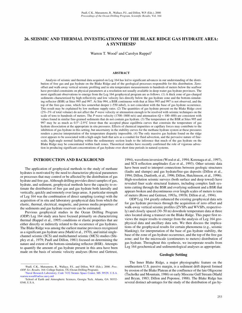
The most time consuming, but also most direct, geophysical tech-nique employed on Leg 164 was vertical seismic profiling (bothWVSP and ZVSP) at Sites 994, 995, and 997 using air-gun andwater-gun sources. Details of the VSP experiments can be found inPaull, Matsumoto, Wallace, et al. (1996). In addition to very accurateestimates of depth to the BSR (440 ± 10 m at Site 995, and 464 ± 8m at Site 997), the ZVSP results (Figs. 2, 3) suggest the presence ofa thick low-velocity zone (Vp < 1550 m/s) below the BSR. Holbrooket al. (1996) attribute the sharp drop in velocity to gas-charged sedi-ments, the upper limit of which is marked by bright, reversed polarityreflections in the SCS data (Figs. 1, 3). However, at Site 994 thisbright reflector is not continuous with the strong BSR observed atSites 995 (440 mbsf) and 997 (464 mbsf). Instead, the Site 994 reflec-tor lies at a depth of ~560 mbsf. As it is traced across the ridge, thisreflector parallels the BSR at Sites 995 and 997 and even appears tolie above the BSR several kilometers to the northeast (Dillon, Hutch-inson, et al., 1996). Although the ~560 mbsf reflector almost certain-ly corresponds to the top of free gas at Site 994, in a more regionalsense the reflector appears to be coincident with the top of a series of
LINE 31 BLAKE RIDGE CREST
Dep
th (
km)
Distance (km)0 5 10 15
3.2
3.0
2.8
SW NE994 995 997
BSR
Figure 1. Line 31 (from Katzman et al., 1994) is shown here unmigrated and converted to depth using interpolated and extrapolated velocities determined fromthe VSPs at Sites 994, 995, and 997. The section is displayed to accentuate the fine-scale faulting (discontinuous reflections) throughout the gas hydrate–stabil-ity zone. The high-amplitude events below 3300 m correspond to gas-charged sediments at Site 994, and continue below the BSR at Sites 995 and 997. Thechange in depth of the top of gas may be due to a lower methane flux at Site 994 than at Sites 995 and 997 (Xu and Ruppel, 1999).
SEISMIC AND THERMAL INVESTIGATIONS
buried faults seen in some seismic sections. At Sites 995 and 997, thecoincidence of the BSR in the SCS data and the top of the free-gaszone as constrained by the VSP data confirms earlier interpretationsof the BSR as a reversed polarity reflector that marks the top of thefree-gas zone (Shipley et al. 1979; Paull and Dillon, 1981).
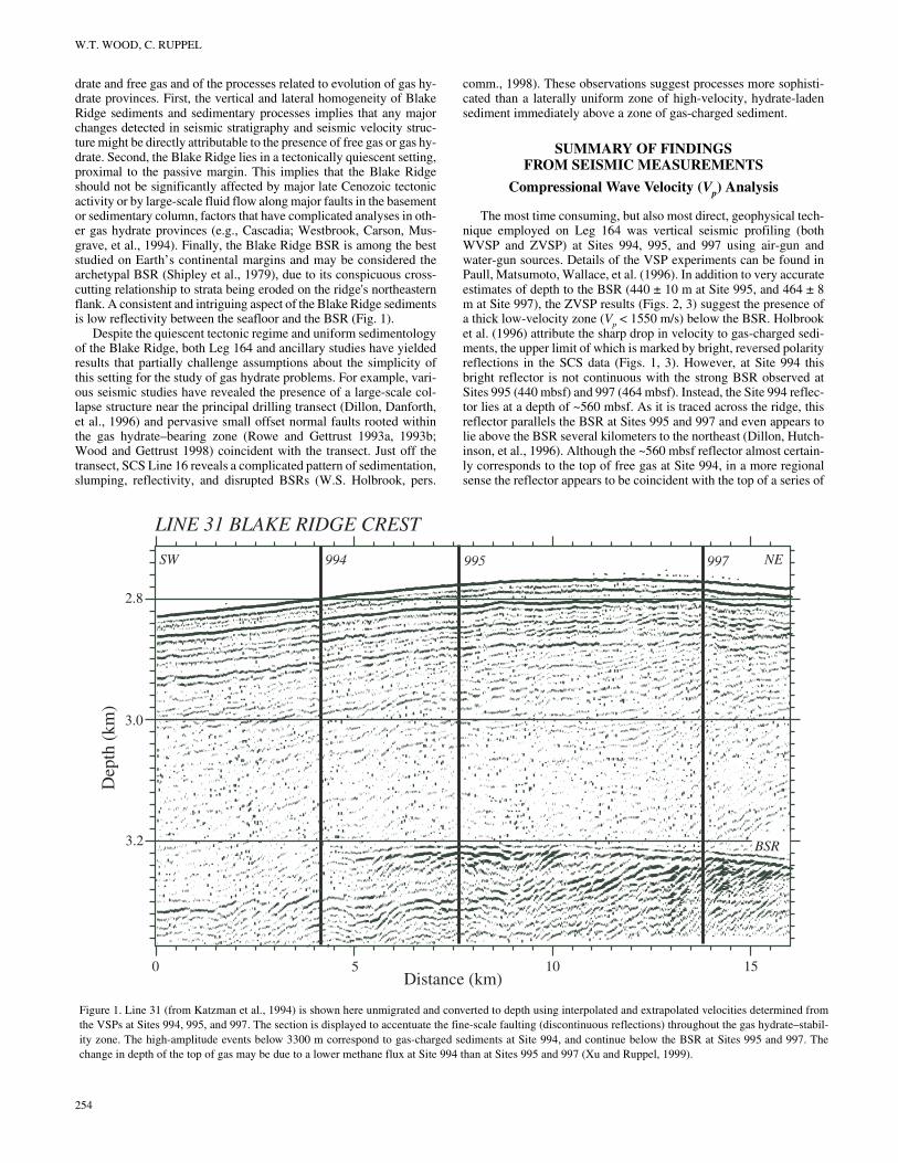
The VSP experiments also provided constraints on Vp of sedi-ments within the gas hydrate zone (GHZ), sediments for which ship-board pore-water analyses yield chloride anomalies consistent withthe presence of gas hydrate under in situ conditions (Paull, Matsumo-to, Wallace et al, 1996). The measured Vp of 1600–1850 m/s (Fig. 2)in the GHZ from 200 to 450 mbsf is somewhat lower than estimatesbased on worldwide averages of fine-grained terrigenous sedimentspresumably free of gas hydrate (Hamilton 1980) and is far lower thanthat of pure hydrate (3800 m/s; Sloan, 1997) or sediment frozen withwater ice (>4000 m/s; Toksoz et al., 1979). Based on the weightedtime average equation of Lee et al. (1993), which uses matrix veloc-ity, porosity, and measured velocity to determine gas hydrate concen-tration, Holbrook et al. (1996) estimate the concentration of gas hy-
0
200
400
600
1400 1600 1800
Velocity (m/s)
0
Dep
th (
mbs
f)
2000
994
995
997
Katzmanet al. (1994)
Ham
ilton (1980)2200 2400
Rowe and Gettrust(1993b)
Woodet al.(1994)
BGHSRangefor 2500to 2900m waterdepth
BGHS For 4000 m water depth
VELOCITIES FROM BLAKE RIDGE AREA
Figure 2. Velocities from VSPs are compared to a global average for terrige-nous sediments (Hamilton, 1980) and to velocities derived from wide-angleOBH data (Katzman et al., 1994) from a 6-km, surface-towed streamer (Woodet al., 1994) and from deep-towed MCS data (Rowe and Gettrust, 1993b). Thedata used by Wood et al. (1994) were acquired 90 km to the west in water2660 m deep, and data used by Rowe and Gettrust (1993b) were acquired 160km to the south in water 4000 m deep. For sediments in the few hundredmeters above the BSR, the lowest velocities are found on the ridge crest andthe highest off the southern flank.
drate in the Blake Ridge to be 5%–7% of pore volume or 2%–3% oftotal volume, consistent with estimates based on chloride anomalies(Paull, Matsumoto, Wallace, et al. 1996).
The seismic velocities determined from the ZVSP data were con-firmed by a WVSP study that revealed ~10% anisotropy in Vp at Site995 (Pecher et al., 1997). Although this result may have some impli-cations for quantifying the concentration and distribution of gas hy-drate (e.g., evenly disseminated vs. as cement in layers), such valuesof anisotropy are not unusual in fine, layered sediments (Levin, 1979)and may not necessarily reflect the presence of gas hydrate.
The velocities within the GHZ determined from the ZVSPs werealso somewhat lower than velocities derived from other measure-ments in the area (Fig. 2). Using wide angle ocean bottom hydrophone(OBH) data from this location, Katzman et al. (1994) estimate that thevelocity of the sediments ~200 m above the BSR is 1900 m/s, similarto the result obtained by Wood et al. (1994) using MCS data acquiredwith a 6-km-long, surface-towed streamer. The highest velocities re-ported for GHZ sediments in the area are as high as 2450 m/s and aredetermined from deep-towed MCS data acquired on the flank of theridge ~160 km to the south and in 4000 m of water (Rowe andGettrust, 1993b). The anisotropy discussed earlier may explain thelower velocities determined on the basis of the ZVSPs. The energy re-corded by the ZVSPs travels in the vertical, slow direction, whereasthe other analyses are based on energy traveling with some horizontalcomponent, resulting in higher estimates of velocity. However,anisotropy of 10% is insufficient to explain the velocity discrepancybetween the ridge crest and flank, which are presumably lithological-ly similar. The difference in velocities might be better explained byhigher gas hydrate concentrations on the flank than on the crest of theridge. As discussed below, higher concentrations of gas hydrate mayreflect more vigorous fluid flux. Greater concentrations of gas hydrateon the ridge flank might be expected if the highly disrupted nature ofthe BSR (Rowe and Gettrust, 1993a) is either a cause or effect of in-creased fluid flux.
Another assessment of Vp values in the study area has been madeby Tinivella and Lodolo (Chap. 28, this volume) based on tomo-graphic inversion of surface-towed MCS data. The results are gener-ally consistent with those obtained from the VSP data but have poorervertical resolution due to the geometry of the data acquisition.
Shear-Wave Velocity (Vs) Analysis
In marine settings, shear-wave velocity measurements with a sur-face source may only be obtained from seismic energy that has beenconverted from P- to S-waves. This requires large incidence angles,or equivalently, large offsets, which were obtained on Leg 164 usingwalk-away VSP (WVSP) data collected with borehole geophones op-erated from the JOIDES Resolution at Sites 994 and 995. The datawere acquired using a 150-in3 generator-injector air-gun sourcetowed behind a second ship (R/V Cape Hatteras) at offsets up to ~5km, allowing incidence angles of up to 45°. A better signal to noiseratio was obtained at Site 995 than at Site 994 because of operationaland mechanical issues (Paull, Matsumoto, Wallace, et al., 1996).Most analyses have therefore concentrated on the Site 995 data. AtSite 995, additional wide-angle data were also obtained through thedeployment of a three-component ocean-bottom seismometer.
To date, the analyses of the WVSP data collected on Leg 164 haverevealed the first known P-to-S conversions from a BSR (Pecher etal., 1996, 1997), an effect attributed to a sharp change in Vs at the re-flector. Other converted shear waves in the data set came from withinthe GHZ itself, but accurate determinations of the depths of theseconversions requires extensive inverse modeling. For the specific ge-ometry of the WVSP experiments, Pecher et al. (1997) show that ifthe shear modulus changes across a given interface, then a significantVs impedance contrast can exist without a significant Vp impedancecontrast. Thus, if small amounts of gas hydrate cement mostly affectthe shear modulus of sediments (Dvorkin and Nur, 1993), then the re-
255

W.T. WOOD, C. RUPPEL
0 5 10 15 20
0
100
200
300
400
500
600
700
Dep
th (
mbs
f)
1400 1600 1800
Velocity (m/s)
0
100
200
300
400
500
600
700
400 480 560Cl - (mM) Equilibrium T (°C)
Site 994
0 20 40 60 80
CaCO3 (%)
Base ofGHZ
A
0
100
200
300
400
500
600
7001400 1600 1800
400 480 560
0 20 40 60 80
Site 995 0 5 10 15 20
Base ofGHZD
epth
(m
bsf)
Velocity (m/s)
Cl - (mM) Equilibrium T (°C)
CaCO3 (%)
B
Figure 3. At each of Sites (A) 994, (B) 995, and (C) 997, a suite of geophysical measurements is compared with the Cl– and CaCO3 profiles. The minima in the Cl– profile (left, circles) are the most direct measure of hydrate concentra-tion available and show roughly the same pattern of varia-tion throughout the GHSZ (200–450 mbsf) at all three sites. At each site note the strong correlation between the peaks in CaCO3 (center left) and high seismic reflectivity (center right) in the upper ~100 m of the sediment column. Note also low Vp (bold curve, left panel) associated with the high seismic reflectivity lower in the section, between 450 and 600 mbsf. These effects accentuate the appearance of weak reflectivity from 100 to 450 mbsf. The intersection of the extrapolated temperature profile (right panel) with the phase equilibrium curve for 3.3% seawater (dashed curve) and fresh water (solid curve) at Sites 995 and 997 lies significantly deeper than the base of gas hydrate stabil-ity inferred from the seismic data, (redrawn from Paull, Matsumoto, Wallace, et al., 1996; Holbrook et al. 1996; and Ruppel, 1997).
256

SEISMIC AND THERMAL INVESTIGATIONS
sults of Pecher et al. (1997) suggest that seismically based determi-nations of the concentration and distribution of gas hydrate may re-quire the use of wide angle data.
Attenuation Analysis
The attenuation of P-waves through Blake Ridge sediments hasbeen investigated by Wood et al. (Chap. 27, this volume) using SCSdata acquired at the sea surface on a transect coincident with the drillsites (Fig. 1, Line 31; Katzman et al., 1994). The analysis was basedon the change in frequency content of the normal incident signal withdepth, and the principal results are shown in Wood et al. (Fig. 2B ofChapter 27, this volume). Although detailed investigations of Q infine-grained sediments are rare, Wood et al. (Chap. 27, this volume)suggest that gas hydrate concentrations on the order of a few percentby volume have little or no effect on P-wave attenuation. Values ofQ = 100–400 determined within the gas hydrate–stability zone (GH-SZ) are not unexpected for fine-grained sediments lacking gas hy-drate (Bowles, 1997). Below the GHSZ, the analysis revealed signif-icantly higher attenuation (Q values as low as ~5), consistent with gascharged sediments (Toksoz et al., 1979). This corroborates the resultsof other seismic studies that indicate the presence of free gas at thisdepth (Holbrook et al., 1996).
Seismic Constraints on Fault-ControlledGas Hydrate Deposition
Leg 164 also provided sample, logging, and paleontological datacritical to the interpretation of seismic images that reveal high-anglefaulting of Blake Ridge sediments. Figure 4A shows surface-towed,
0
100
200
300
400
500
600
7001400 1600 1800
400 480 560
0 20 40 60 80
Site 997 0 5 10 15 20
Base ofGHZ
Dep
th (
mbs
f)
Velocity (m/s)
Cl - (mM) Equilibrium T (°C)
CaCO3 (%)
C
Figure 3 (continued).
10- to 240-Hz SCS data collected in the vicinity of Site 997 as part ofLine 31 (Katzman et al., 1994). These data are very mildly filtered(cosine ramp from 0 to 1 between 5 and 10 Hz and from 1 to 0 be-tween 200 and 240 Hz) and have not been migrated, because suchprocessing may blur higher frequency waveforms. The image showsfaulting (lateral discontinuities) throughout the GHSZ and underly-ing sediments. However, it is difficult to trace individual faults or de-termine which, if any, fault or faults may have been intersected dur-ing drilling.
Evidence that a fault plane was intersected at Site 997 comes fromthe composite paleontological record (Fig. 4D) to a depth of 424 mbsfin Hole 997A and from 416 to 750 mbsf in Hole 997B (Paull, Matsu-moto, Wallace, et al., 1996). A temporal hiatus between 360 and 375mbsf (arrow in Fig. 4D) corresponds to ~14 m of missing section.There is no indication in the seismic data of an exceptionally strongreflector or truncated reflectors corresponding to an erosional surfaceat this depth. Normal faulting, which is seen in seismic data andwhich can account for missing section, is the more likely explanation.
A higher resolution image of this type of faulting was acquired in1993 at a location ~1 km to the southeast of the drilling transect usingthe Naval Research Laboratory’s deep-towed acoustics geophysicssystem (DTAGS, Gettrust et al., 1991). The small sample of unmi-grated data shown in Figure 5 is of the same vertical and horizontaldimension as the SCS data in Figure 3. The 24-channel vertical arrayDTAGS data were moved out, median stacked, and shifted to makethe seafloor horizontal; depth converted using velocities obtained atSite 997 by Holbrook et al. (1996); and gained with a linear ramp ofslope 0.08 m–1 beginning at 80 mbsf. The DTAGS data exhibit clearimages of individual faults and show that the faults are spaced tens tohundreds of meters apart, frequently penetrate the BSR, and are quite
257

W.T. WOOD, C. RUPPEL
prevalent on the ridge crest (Rowe et al., 1995; Wood and Gettrust,1998). Displacement across the faults, which the DTAGS sectionclearly shows to be syndepositional, is ~14 m at 340 mbsf but lessthan vertical resolution of the data at ~30 mbsf. This amount of dis-placement is consistent with the thickness of missing section estimat-ed from the paleontological results. That the perturbation of the BSRat the location of the faults is significantly smaller than the displace-ment on the fault might be partially attributed to a small pressurechange across the fault (Rowe and Gettrust, 1993a). The faults havenormal sense displacement and associated minor antithetic faults thatproduce small grabens.
The significance of the faulting is clear when viewed in the con-text of other Leg 164 geophysical data. A massive section of hydrate~20 cm long (pure hydrate, from which virtually all sediment hasbeen excluded) was recovered at 330 mbsf at Hole 997A but not atHole 997B, located only 20 m away to the northwest (Fig. 4A). Sub-sequent logging of Hole 997B revealed a thin (less than a few metersthick) zone of anomalously high acoustic velocity and resistivity at365 mbsf (Figs. 4B and 4C, respectively), interpreted as an indicatorof localized concentrations of methane hydrate (Paull, Matsumoto,Wallace, et al., 1996). The velocity and resistivity anomalies in Hole997B occurred 35 m deeper than the massive hydrate in Hole 997Aand was inferred to indicate the presence of gas hydrate in ~23% ofpore volume (Paull, Matsumoto, Wallace, et al., 1996).
Hole 997A Hole 997B
400
Paleo. Holes997A, 997B
Resis. LogHole 997B
Distance (m)0
Velocity (m/s)20001600
Resis. (Ω-m)1.20.8
Age (Ma)2 4 6
400
300
100
0
330
Dep
th (
mbs
f)
Line 31
BSR
360
Sonic LogHole 997B
SE NW
HIATUS
A B C D
Figure 4. (A) This seismic section shows the position of Holes 997A and 997B with ~10 m accuracy. Massive hydrate was encountered in Hole 997A at 330 mbsf. (B) Sonic and (C) resistivity logs from Hole 997B suggest significantly higher hydrate concentrations (up to 23% of pore volume) at ~365 mbsf, consistent with hydrate accu-mulation on a high-angle fault. Identification of the indi-vidual fault intersected is not possible. (D) Composite paleontological results from these holes shows a hiatus corresponding to ~14 m of missing section (arrow), simi-lar to the throw seen on faults at this depth in Figure 5 (components redrawn from Paull, Matsumoto, Wallace, et al., 1996).
258
Highly localized concentrations of gas hydrate like those discov-ered in Hole 997A are consistent with hydrate accumulation con-trolled by strong fluid advection (Xu and Ruppel, 1999), probably ina high-permeability zone represented by a single high-angle faultcrossing both holes. If gas hydrate concentration was instead prima-rily controlled by sediment stratigraphy, two holes separated by only20 m might be expected to exhibit sediment anomalously rich in hy-drate at nearly identical depths. Although the paleontologically deter-mined intersection of a possible fault and the two holes is inexplica-bly reported 30–40 m deeper than the level that yielded the massivehydrate, it seems fairly certain that at least one fault was intersectedand that this fault likely promotes fluid advection and gas hydrate for-mation.
SUMMARY OF FINDINGSFROM TEMPERATURE MEASUREMENTS
Three downhole tools were used to acquire temperature data at anominal vertical spacing of 30–50 m to depths as great as ~415 mbsfat Sites 994, 995, and 997. The deepest measurements at both Sites995 and 997 were to within 55 m above the BSR and provide an un-precedented constraint on temperatures deep within a thick GHZ. De-tails of the data acquisition and preliminary analysis can be found in

SEISMIC AND THERMAL INVESTIGATIONS
Paull, Matsumoto, Wallace, et al. (1996), and Ruppel (1997). TheLeg 164 temperature data can be used to constrain the conductive andadvective components of heat flux, to evaluate disparities betweentraditional heat flow data (Ruppel et al., 1995) and in situ measure-ments, and to determine temperatures at the BSR.
DTAGS
0 800400
Distance (m)
400
300
100
0D
epth
(m
bsf)
NW SE
Figure 5. Deep-towed, high-frequency vertical array data clearly show notonly the position, but also the displacement on faults that penetrate the BSR.This is a small sample of a larger data set that reveals fault spacing at tens tohundreds of meters (from Wood and Gettrust, 1998).
Figure 3 shows the equilibrium temperature data at Sites 994, 995,and 997. The highly linear (uniform) nature of the temperature vs.depth curves is consistent with conduction-dominated heat transferdeeper than 30 mbsf. Calculated thermal gradients are 33.3 ± 1.5°Ckm–1, 32.7 ± 0.7°C km–1, and 36.9 ± 0.7°C km–1 for Sites 994, 995,and 997, respectively, and the sediments are not in equilibrium withthe bottom-water temperatures (BWT) measured at the time of drill-ing (Ruppel, 1997). Conductive gradients out of thermal equilibriumwith bottom water were previously noted in a traditional marine heat-flow survey that acquired temperature and in situ thermal conductiv-ity measurements in the upper 3–5 m of sediment within 1–2 km ofeach drill site (Ruppel et al., 1995). The lack of thermal equilibriumbetween BWT and the sediments in both data sets is consistent withlarge (up to ± 0.4°C), rapid (timescale of weeks) fluctuations in BWTin this area (Ruppel et al., 1995), an inference confirmed by a 6.25-yrtemperature record obtained on the Blake Plateau, south of the Leg164 study area (Broek, 1969).
An important result that emerges from the comparison of the Leg164 downhole temperature data (C. Ruppel, unpubl. data) and the tra-ditional heat-flow measurements (Ruppel et al., 1995) is a disparityof up to 30% between the thermal gradients determined from the twodata sets. Variations in thermal conductivity between the shallow anddeep parts of the section cannot explain this disparity. The thermalgradients measured in the upper 3–5 m at the transect site (Ruppel etal., 1995) are remarkably consistent and cover the narrow range from46.4° to 47.8°C km–1 with uncertainties as large as ±1.5°C. Theseshallow data reveal no statistically significant increase in thermalgradient between Sites 994/995 and Site 997, in contrast to the ~10%increase in gradient measured between these locations on Leg 164. AtSite 997, the vertical and lateral distribution of gas hydrate and seis-mic images imply that the holes may intersect a buried fault systemthat could focus upwelling fluids and lead to an increase in the deepthermal gradient at this site. The lateral resolution of the traditionalheat flow data set is probably too low to detect such focused flownear Site 997, even if this flow did continue to near-surface depths. Itshould also be noted that for the traditional marine heat flow data tolie on the same temperature profile as the downhole temperature datarequires significant nonuniformity (concave down gradient) in thecomposite thermal gradient between the seafloor and 30–50 mbsf.
Three independent estimates of temperature at the BSR can be ob-tained from Leg 164 and peripheral data sets (C. Ruppel, unpubl. da-ta). The simplest method uses the technique described by Yamano etal. (1982) to determine the BSR temperature by combining the gashydrate phase equilibria and constraints on the depth of the BSR be-low the seafloor. Assuming that pressure in the sediments is hydro-static, the BSR temperatures estimated using this method are 21.6°–22.7ºC at Sites 995 and 997 for stability boundaries based on theBrown et al. (1996) fit to the Dickens and Quinby-Hunt (1994) resultsfor 3.3% NaCl water and on Sloan (1998) for freshwater. The secondestimate can be derived from downward extrapolation of the shallowthermal gradients measured by Ruppel et al. (1995) to the depth of theBSR. This calculation yields BSR temperature estimates of ~24° and~25.5°C at Sites 995 and 997, respectively. The third and probablymost accurate estimate is based on downward projection of the Leg164 in situ temperature data and yields BSR temperatures of 17.4°–18.8°C and 19.8°–21.1°C at Sites 995 and 997, respectively (Ruppel,1997).
The disparities between these BSR temperature estimates high-light several problems with using data other than those collected indeep boreholes to constrain the thermal state of sediments within aGHZ. First, if the in situ data acquired on Leg 164 are presumed toprovide the most accurate constraint on BSR temperatures, then evenvery high quality traditional heat flow data may yield an overestimateof actual BSR temperatures (C. Ruppel, unpubl. data). It is strikingthat this result was obtained in a low advective flux setting (Egebergand Dickens, 1999) in a sediment drift deposit near a tectonically qui-
259
W.T. WOOD, C. RUPPEL
escent continental margin. BSR temperature estimates based ondownward extrapolation of surface heat flow may be even more in-accurate in active margin gas hydrate provinces characterized by highfluid-flux rates, variegated sediments, and tectonic deformation. Sec-ond, the method of Yamano et al. (1982) only provides a rough mea-sure of the thermal gradient in the sediments above the BSR if the ap-proximate BWT is known and if sediments can be assumed to be inthermal equilibrium with the bottom water. Third, the BSR tempera-tures at Sites 995 and 997 lie 2.9°C (Ruppel, 1997) below those pre-dicted at the base of the GHSZ using presently accepted stabilitycurves (Dickens and Quinby-Hunt, 1994; Sloan, 1997).
Several physical and chemical processes have been invoked to ex-plain low temperatures at the Blake Ridge BSR. Capillary forces inthe fine-grained sediments (e.g., Clennell et al., in press) or contro-versial third-surface effects associated with the high concentration ofclay minerals (Cha et al., 1988; Kotkoskie et al., 1990) may inhibitgas hydrate stability. Alternately, the phase equilibria for systems atthese pressures (~32.2 MPa) may still be too poorly known to drawreliable conclusions about the significance of the apparently coldtemperatures measured deep within the GHZ, close to the BSR. In-deed, new theoretical curves emerging from statistical thermodynam-ics calculations (Tohidi et al., 1995) yield dissociation temperaturesmuch closer to those determined for the Blake Ridge BSR althoughcapillary effects may still need to be invoked to explain the full mag-nitude of the apparent temperature deficit at the BSR (Clennell et al.,in press).
DISCUSSION
Blanking
The relatively lower reflection amplitudes of some sedimentswithin the Blake Ridge GHSZ compared to sediments below theGHSZ have been previously interpreted as reduction of impedancecontrast and reflectivity due to cementation of sediment by gas hy-drate (Lee et al., 1993). Holbrook et al. (1996) did not find the anom-alously high velocities one would expect for frozen sediment, andthey attributed the lack of impedance contrasts within the GHSZ tothe homogeneity of the sediments at this location, which may only bereflective below the GHSZ because of the presence of free gas withinpreferentially porous strata. Although the velocities determined fromthe VSPs suggest minimal cementation on a scale of tens to hundredsof meters, the relative amplitude reduction (or blanking) may involvefactors other than merely sediment homogeneity.
In some highly localized zones, particularly near faults, the Leg164 sampling and logging results imply that gas hydrate concentra-tions may be high enough to fill a significant portion of pore spaceand to affect seismic velocity at submeter- to meter-length scales.Dillon et al. (1994) describe “fingers” of blanking that extend upwardinto the GHSZ from faults below the BSR. Such blanking zones maycontinue to even shallower depths in the section along unresolvedfaults. Cementation from high concentrations of gas hydrate are morelikely in fault zones than in adjacent, unfaulted sediments character-ized by presumably lower fluid flux. However, these potentially ce-mented fault zones are not oriented horizontally, may be quite irreg-ular in shape and impedance, and may thus be more efficient in scat-tering energy outward rather than directly upward to the receivers.Thus, a “blank” zone in seismic data may imply a paucity of nearlyhorizontal reflectors, not necessarily a lack of impedance contrasts.The kind of scattering described here typically exhibits strong fre-quency dependence (e.g. Clay and Medwin, 1977) and would likelyyield different results when studied with seismic systems of differentfrequencies.
Another phenomenon that may be responsible for blanking atlarger scales is the increasing throw with depth on the syndeposition-al faults imaged in the DTAGS seismic data (Fig. 5). A spherical,spreading seismic wave has a finite lateral resolution that decreases
260
with decreasing frequency and increasing distance from the reflector.Inhomogeneities that are below the resolution are averaged, and, dueto scattering, generally result in lower reflectivity being recorded bythe receivers (Clay and Medwin, 1977). For wavelengths greater than~30 m, (less than ~60 Hz), a 15-m displacement in a reflector createsdestructive interference, and the observed reflectivity is diminished.For data of this frequency, we would therefore expect a decrease inobserved reflectivity with depth, because the lateral heterogeneity in-creases due to increasing fault throw. Destructive interference willincrease with the distance from the source as more heterogeneity isincorporated into the first Fresnel zone. This may explain why thehigh-frequency, deep-tow data shown in Figure 5 (250–650 Hz, at750 m above the BSR) does not show as great a discrepancy betweenreflectors just above and just below the top of gas as seen in the sur-face-tow data of Figure 1 (10–240 Hz, 3250 m above the BSR). Thelateral heterogeneity of the faulted sediments, combined with thenonhorizontal distribution of hydrate, leads us to believe that the re-duced reflectivity is more likely due to scattering and destructive in-terference than to reduced impedance contrasts from sediment ce-mentation.
Phase Equilibria and Seismically Important Boundaries in the Reservoir
Theoretical modeling of the steady-state methane gas hydrate sys-tem in porous marine sediments (Xu and Ruppel, 1999) reveals sev-eral misconceptions about the significance of the BSR relative to thebase of the GHSZ and GHZ. Although the intersection of the temper-ature profile with the phase boundary does mark the lower limit ofgas hydrate stability (base of GHSZ) and the potential upper limit forthe top of free gas, several factors control where gas hydrate (GHZ)and free gas actually occur. Most notably, the GHZ can only extendas deep as the base of the stability zone/top of the free-gas zone if therate of methane supply exceeds a critical rate whose value dependson fluid-flux rate, energy flux, and other parameters. Furthermore,under certain conditions, the top of the free-gas zone may be separat-ed from the base of the GHSZ by a layer of sediments lacking bothfree gas and gas hydrate.
Xu and Ruppel (1999) note that these results have particular sig-nificance for interpreting seismic data and other observations madeon ODP Leg 164. At Site 994, where a strong BSR continuous withthose at the adjacent sites is lacking, Holbrook et al. (1996) inferredthe presence of free gas at ~560 mbsf. Chloride anomalies between196 and 456 mbsf at this site (Paull, Matsumoto, Wallace, et al.,1996) are consistent with pore-water freshening (Hesse and Harrison,1981) and the in situ occurrence of gas hydrate. Thus, the top of thefree-gas zone at Site 994 appears to lie significantly below the baseof the actual zone of gas hydrate occurrence (GHZ), consistent withmodels in which the methane supply rate is less than the critical val-ue. At Sites 995 and 997 (strong BSR), the top of the free-gas zoneand the base of the GHZ are effectively coincident, which impliesthat the methane supply rate at these sites exceeds the critical value.Thus, if all other physical parameters at Sites 994 and 995 are approx-imately equivalent, the 3-km distance that separates the two sites maymark a transition from precritical to critical methane supply rates (C.Ruppel, unpubl. data). This transition in methane supply rates is ac-companied by a transition from noncoincidence to coincidence of thetop of free gas and the base of the GHZ/GHSZ and a consequentchange from no BSR (Site 994) to a strong BSR (Site 995). If allmethane were supplied by biogenic processes occurring below theGHSZ, then the observed coincidence between the top of free gas andthe base of the GHZ can be used to determine the critical rate of meth-ane supply and the potential size of the methanogenic bacterial pop-ulation (Xu and Ruppel, 1999).
Figure 6 shows the predicted depths of different boundaries with-in the Blake Ridge gas hydrate system and the relationship betweenmethane supply rate and the depth to the top of the free-gas zone, de-
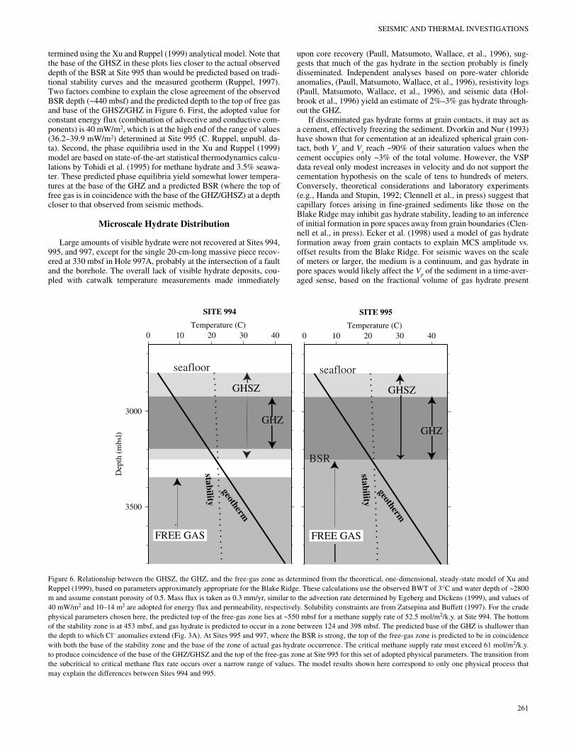
SEISMIC AND THERMAL INVESTIGATIONS
termined using the Xu and Ruppel (1999) analytical model. Note thatthe base of the GHSZ in these plots lies closer to the actual observeddepth of the BSR at Site 995 than would be predicted based on tradi-tional stability curves and the measured geotherm (Ruppel, 1997).Two factors combine to explain the close agreement of the observedBSR depth (~440 mbsf) and the predicted depth to the top of free gasand base of the GHSZ/GHZ in Figure 6. First, the adopted value forconstant energy flux (combination of advective and conductive com-ponents) is 40 mW/m2, which is at the high end of the range of values(36.2–39.9 mW/m2) determined at Site 995 (C. Ruppel, unpubl. da-ta). Second, the phase equilibria used in the Xu and Ruppel (1999)model are based on state-of-the-art statistical thermodynamics calcu-lations by Tohidi et al. (1995) for methane hydrate and 3.5% seawa-ter. These predicted phase equilibria yield somewhat lower tempera-tures at the base of the GHZ and a predicted BSR (where the top offree gas is in coincidence with the base of the GHZ/GHSZ) at a depthcloser to that observed from seismic methods.
Microscale Hydrate Distribution
Large amounts of visible hydrate were not recovered at Sites 994,995, and 997, except for the single 20-cm-long massive piece recov-ered at 330 mbsf in Hole 997A, probably at the intersection of a faultand the borehole. The overall lack of visible hydrate deposits, cou-pled with catwalk temperature measurements made immediately
upon core recovery (Paull, Matsumoto, Wallace, et al., 1996), sug-gests that much of the gas hydrate in the section probably is finelydisseminated. Independent analyses based on pore-water chlorideanomalies, (Paull, Matsumoto, Wallace, et al., 1996), resistivity logs(Paull, Matsumoto, Wallace, et al., 1996), and seismic data (Hol-brook et al., 1996) yield an estimate of 2%–3% gas hydrate through-out the GHZ.
If disseminated gas hydrate forms at grain contacts, it may act asa cement, effectively freezing the sediment. Dvorkin and Nur (1993)have shown that for cementation at an idealized spherical grain con-tact, both Vp and Vs reach ~90% of their saturation values when thecement occupies only ~3% of the total volume. However, the VSPdata reveal only modest increases in velocity and do not support thecementation hypothesis on the scale of tens to hundreds of meters.Conversely, theoretical considerations and laboratory experiments(e.g., Handa and Stupin, 1992; Clennell et al., in press) suggest thatcapillary forces arising in fine-grained sediments like those on theBlake Ridge may inhibit gas hydrate stability, leading to an inferenceof initial formation in pore spaces away from grain boundaries (Clen-nell et al., in press). Ecker et al. (1998) used a model of gas hydrateformation away from grain contacts to explain MCS amplitude vs.offset results from the Blake Ridge. For seismic waves on the scaleof meters or larger, the medium is a continuum, and gas hydrate inpore spaces would likely affect the Vp of the sediment in a time-aver-aged sense, based on the fractional volume of gas hydrate present
FREE GAS
GHZ
GHSZ
SITE 994
3000
3500
Dep
th (
mbs
l)
0 10 20 30 40Temperature (C)
geotherm
stability
FREE GAS
GHZ
GHSZ
SITE 995
0 10 20 30 40Temperature (C)
geotherm
stability
seafloor
BSR
seafloor
Figure 6. Relationship between the GHSZ, the GHZ, and the free-gas zone as determined from the theoretical, one-dimensional, steady-state model of Xu andRuppel (1999), based on parameters approximately appropriate for the Blake Ridge. These calculations use the observed BWT of 3°C and water depth of ~2800m and assume constant porosity of 0.5. Mass flux is taken as 0.3 mm/yr, similar to the advection rate determined by Egeberg and Dickens (1999), and values of40 mW/m2 and 10–14 m2 are adopted for energy flux and permeability, respectively. Solubility constraints are from Zatsepina and Buffett (1997). For the crudephysical parameters chosen here, the predicted top of the free-gas zone lies at ~550 mbsf for a methane supply rate of 52.5 mol/m2/k.y. at Site 994. The bottomof the stability zone is at 453 mbsf, and gas hydrate is predicted to occur in a zone between 124 and 398 mbsf. The predicted base of the GHZ is shallower thanthe depth to which Cl– anomalies extend (Fig. 3A). At Sites 995 and 997, where the BSR is strong, the top of the free-gas zone is predicted to be in coincidencewith both the base of the stability zone and the base of the zone of actual gas hydrate occurrence. The critical methane supply rate must exceed 61 mol/m2/k.y.to produce coincidence of the base of the GHZ/GHSZ and the top of the free-gas zone at Site 995 for this set of adopted physical parameters. The transition fromthe subcritical to critical methane flux rate occurs over a narrow range of values. The model results shown here correspond to only one physical process thatmay explain the differences between Sites 994 and 995.
261
W.T. WOOD, C. RUPPEL
(Wyllie et al. 1958; Lee et al., 1996). A small (2%–3%) concentrationof hydrate would thus have only a small effect on elastic properties,a result consistent with the observed ZVSP velocities.
WVSP data are also affected by the microscale distribution of hy-drate. The converted S-waves that arise within the GHZ occur at ho-rizons where shear modulus changes abruptly, possibly due to gas hy-drate forming at grain contacts over zones that are hundreds of metersthick. However, it is difficult to unambiguously ascribe changes inshear moduli to the presence of gas hydrate or the cementation of sed-iments by gas hydrate. Whether the contrasts in shear moduli aremore significant than would be expected for compacting sedimentlacking gas hydrate remains to be determined. Although Vp , Vs , andQ measurements from Leg 164 do not clearly resolve the microscaledistribution of gas hydrate, current analyses suggest that the elasticeffects from 2% to 3% gas hydrate by volume are small.
Faults
The Leg 164 geophysical data are consistent with increased con-centration of gas hydrate near faults of the type shown in the seismicimages of Figures 1 and 5. Such features were previously suspectedto be possible conduits for advective flux (Wood et al., 1997) and theescape of methane gas (Rowe et al., 1995). As shown quantitativelyby Xu and Ruppel (1999), large concentrations of gas hydrate or highaccumulation rates are almost unequivocally linked to high rates offluid flux and methane supply to porous sediments within the stabil-ity zone. At present, we lack a detailed high-resolution image that canprecisely constrain the angle at which the boreholes may have inter-sected a fault. Furthermore, the degree of variability in gas hydrateconcentration (Paull, Matsumoto, Wallace, et al., 1996) betweenHoles 997A (up to 100% at 330 mbsf) and 997B (~23% at 365 mbsf)and sparse lateral sampling render simple interpretations impossible,particularly if the holes intersect the same fault. Quantitative calcula-tions on a one-dimensional system indicate that gas hydrate accumu-lations in homogeneous porous media should be either relatively uni-form with depth or more concentrated near the base of the zone (~450mbsf), depending on the rate of mass flux through advection-domi-nated systems (Xu and Ruppel, 1999). If a fault represents a zone ofeffectively 100% porosity and Holes 997A and 997B intersect thesame fault, then the inferred pattern of gas hydrate concentrations inboth the vertical and lateral directions does not conform to the patternpredicted by simple models. More extensive modeling using more re-alistic parameters based on better field constraints on the lateral andvertical distribution of gas hydrate will be necessary to address the is-sue of gas hydrate distribution along conduits.
The thermal data do not reveal a significant advective componentat any of the sites, but the slightly elevated thermal gradient at Site997 is consistent with the intuitive notion that gas hydrate near a fluidconduit (fault) lies closer to the stability boundary than gas hydrate inthe surrounding sediments and at adjacent sites. The fault zone pro-vides an obvious escape pathway for warmer than in situ methane-laden fluids produced through dissociation of gas hydrate. Gas hy-drate in and near such fault zones may represent a less stable, moremobile subreservoir whose dissociation might be triggered by rela-tively small bottom-water temperature increases or sea-level falls(possibly accompanying climate change; Paull et al., 1991; Dickenset al., 1995, 1997) or even episodes of rapid sedimentation (e.g.,Pecher et al., 1998).
The potential high concentration of gas hydrate along faults mayalso affect seafloor stability. Dissociation of gas hydrates has longbeen linked to large mass-wasting phenomena produced when sedi-ments presumably liquefy during gas hydrate dissociation (Kayenand Lee, 1991). If the more volatile (more mobile and less stable) gashydrate deposits are concentrated along sites of previous strain(faults), then initial dissociation zones should be more localized.Thus, there is an even greater potential for the initiation of mass-
262
wasting events at existing faults than would be expected in areas withno gas hydrate.
CONCLUSIONS
The geophysical data acquired on Leg 164 have contributed sub-stantially to our understanding of methane hydrate distribution, for-mation, and dissociation on the Blake Ridge with implications forother areas. The data clearly show that a significant portion of the to-tal methane exists as free gas below the base of gas hydrate stabilityand that large deposits of gas hydrate may be most closely associatedwith fluid flux along faults. Thus, even in this setting close to a pas-sive margin, high rates of localized advective flux appear to be criti-cal to the development of massive gas hydrates, a result confirmed byrecent quantitative modeling. The possible localization of gas hydrateon fault planes within the Blake Ridge may have important implica-tions for seafloor stability and for the volatility of the gas hydrate res-ervoir during even minor climate change or sedimentological events.
Preliminary analyses of wide-angle seismic data have revealed P-wave anisotropy and a significant shear modulus contrast within theGHSZ on the Blake Ridge. The Leg 164 results have also pointed toa more sophisticated potential cause of seismic blanking than cemen-tation by hydrate, challenging the use of blanking as a means of esti-mating hydrate concentrations in marine sediments. Wide-angle seis-mic data and the analysis of P-to-S conversions seem to hold morepromise for remotely quantifying rock physical properties and thesmall amounts of gas hydrate present.
Thermal data acquired on the Blake Ridge imply that tempera-tures at the BSR are lower than the predicted temperature of dissoci-ation at Sites 995 and 997. At present, this observation can only beexplained by the inhibition of gas hydrate stability due to a physicalor chemical process or by failure of the accepted phase equilibria toproperly represent in situ conditions for the primarily methane sys-tem at 32.2 MPa pressure. The ODP Leg 164 temperature data loose-ly confirm the interpretation that Site 997 may be characterized byenhanced advection along buried faults.
Recent theoretical modeling offers one explanation for the differ-ent relationships between the free-gas zone and the base of the GHZat Sites 994 and 995/997. The occurrence of the free-gas zone tens ofmeters deeper than the GHZ and the theoretical base of GHSZ at Site994 may imply that the methane flux at this site is less than a criticalvalue. At Sites 995 and 997, the apparent coincidence between thebase of the GHZ, the base of the GHSZ, and the top of the free-gaszone produces a strong BSR and may imply that the critical methanesupply rate has been exceeded.
ACKNOWLEDGMENTS
The authors thank C.K. Paull, R. Matsumoto, W.P. Dillon, P.Wallace, and the JOIDES Resolution technical staff for strong sup-port of the geophysical aspects of Leg 164; W.S. Holbrook for skill-fully planning and executing the VSP program; and I. Pecher, H.Hoskins, D. Lizarralde, D. Hutchinson, and others who contributed tothe acquisition and analysis of geophysical data. J. Gettrust, R. Hynd-man, W. Dillon, and A. Cooper provided critical reviews of thismanuscript. This work was funded by ONR Element/Project Number0602435N/BE-35-2-02 (Wood) and JOI-USSSP F000319 (Ruppel).Naval Research Lab contribution BA/7432--98-0002.
REFERENCES
Bowles, F.A., 1997. Observations on attenuation and shear-wave velocity infine-grained, marine sediments. J. Acoust. Soc. Am., 101:3385–3397.
Broek, H.W., 1969. Fluctuations in bottom water temperature at 2000-meterdepth off the Blake Plateau. J. Geophys. Res., 74:5449–5452.

SEISMIC AND THERMAL INVESTIGATIONS
Brown, K.M., Bangs, N.L., Froelich, P.N., and Kvenvolden, K.A., 1996. Thenature distribution and origin of gas hydrate in the Chile Triple Junctionregion. Earth Planet. Sci. Lett., 139:471–483.
Cha, S.B., Ouar, H., Wildeman, T.R., and Sloan, E.D., 1988. A third surfaceeffect on hydrate formation. J. Phys. Chem., 92:6492–6494.
Clay, C.S., and Medwin, H., 1977. Acoustical Oceanography: Principles andApplications: New York (Wiley).
Clennell, M.B., Hovland, M., Booth, J.S., Henry, P., and Winters, W.J., inpress. Formation of natural gas hydrates in marine sediments. Part 1:Conceptual model of gas hydrates growth conditioned by host sedimentproperties. J. Geophys. Res.
Dickens, G.R., Castillo, M.M., and Walker, J.G.C., 1997. A blast of gas inthe latest Paleocene: simulating first-order effects of massive dissociationof oceanic methane hydrate. Geology, 25:259–262.
Dickens, G.R., O’Neil, J.R., Rea, D.K., and Owen, R.M., 1995. Dissociationof oceanic methane hydrate as a cause of the carbon isotope excursion atthe end of the Paleocene. Paleoceanography, 10:965–971.
Dickens, G.R., and Quinby-Hunt, M.S., 1994. Methane hydrate stability inseawater. Geophys. Res. Lett., 21:2115–2118.
Dillon, W.P., Danforth, W.W., Hutchinson, D.R., Drury, R.M., Taylor, M.H.,and Booth, J.S., 1998. Evidence for faulting related to dissociation of gashydrate and release of methane off the southeastern United States. InHenriet, J.P., and Mienert, J. (Eds.), Gas Hydrates: Relevance to WorldMargin Stability and Climate Change. Geol. Soc. Spec. Publ. London,137:293–302.
Dillon, W.P., Hutchinson, D. R., and Drury, R.M., 1996. Seismic reflectionprofiles on the Blake Ridge near Sites 994, 995, and 997. In Paull, C.K.,Matsumoto, R., Wallace, P.J., et al., Proc. ODP, Init. Repts., 164: CollegeStation, TX (Ocean Drilling Program), 47–56.
Dillon, W.P., Lee, M.W., and Coleman, D.F., 1994. Identification of marinehydrates in situ and their distribution off the Atlantic coast of the UnitedStates. In Sloan, E.D., Jr., Happel, J., and Hnatow, M.A. (Eds.), Ann. N.Y.Acad. Sci., Int. Conf. Natural Gas Hydrates, 715:364–380.
Dillon, W.P., and Popenoe, P., 1988. The Blake Plateau basin and CarolinaTrough. In Sheridan, R.E., and Grow, J.A. (Eds.), The Atlantic Continen-tal Margin, U.S., Geol. Soc. Am., Geology of North America, I-2:291–328.
Dvorkin, J., and Nur, A., 1993. Rock physics for characterization of gashydrates. In The Future of Energy Gases. Geol. Surv. Prof. Pap. U.S.,1570.
Ecker, C., Dvorkin, J., and Nur, A., 1998. Sediments with gas hydrates: inter-nal structure from seismic AVO. Geophysics, 63:1659–1669.
Egeberg, P.K., and Dickens, G.R., 1999. Thermodynamic and pore waterhalogen constraints on gas hydrate distribution at ODP Site 997 (BlakeRidge). Chem. Geol., 153:53–79.
Gettrust, J.F., Ross, J.H., and Rowe, M.M., 1991. Development of a low fre-quency, deep tow geoacoustics system. Sea Technol., 32:23–32.
Hamilton, E.L., 1980. Geoacoustic modeling of the seafloor. J. Acoust. Soc.Am., 68:1313–1340.
Handa, Y.P., and Stupin, D., 1992. Thermodynamic properties and dissocia-tion characteristics of methane and propane hydrates in 70-Å-radius sil-ica-gel pores. J. Phys. Chem., 96:8599–8603.
Hesse, R., and Harrison, W.E., 1981. Gas hydrates (clathrates) causing pore-water freshening and oxygen isotope fractionation in deep-water sedi-mentary sections of terrigenous continental margins. Earth Planet. Sci.Lett., 55:453–462.
Holbrook, W.S., Hoskins, H., Wood, W.T., Stephen, R.A., Lizzarralde, D.,and the Leg 164 Science Party, 1996. Methane gas-hydrate and free gason the Blake Ridge from vertical seismic profiling. Science, 273:1840–1843.
Katzman, R., Holbrook, W.S., and Paull, C.K., 1994. A combined verticalincidence and wide-angle seismic study of a gas hydrate zone, BlakeOuter Ridge. J. Geophys. Res., 99:17975–17995.
Kayen, R.E., and Lee, H., 1991. Pleistocene slope instability of gas hydrate-laden sediment on the Beaufort Sea Margin. Mar. Geotechnol., 10:125–141.
Korenaga, J., Holbrook, W.S., Singh, S.C., and Minshull, T.A., 1997. Naturalgas hydrates on the southeast U.S. margin: constraints from full wave-form traveltime inversions of wide-angle seismic data. J. Geophys. Res.,102:15345–15365.
Kotkoskie, T.S., Al-Ubaidi, B., and Sloan, E.D., 1990. Inhibition of gashydrates in water-based drilling muds. Proc. Soc. Pet. Eng. Annu. Tech.Conf. Exhib., SPE, 4:359–368.
Lee, M.W., Hutchinson, D.R., Collett, T.S., and Dillon, W.P., 1996. Seismicvelocities for hydrate-bearing sediments using weighted equation. J.Geophys. Res., 101:20347–20358.
Lee, M.W., Hutchinson, D.R., Dillon, W.P., Miller, J.J., Agena, W.F., andSwift, B.A., 1993. Method of estimating the amount of in situ gashydrates in deep marine sediments. Mar. Pet. Geol., 10:493–506.
Levin, F. K., 1979. Seismic velocities in transversely isotropic media. Geo-physics, 44:918–936.
Markl, R.G., and Bryan, G.M., 1983. Stratigraphic evolution of the BlakeOuter Ridge. AAPG Bull., 67:663–683.
Markl, R.G., Bryan, G.M., and Ewing, J.I., 1970. Structure of the Blake-Bahama outer ridge. J. Geophys. Res., 75:4539–4555.
Paull, C.K., and Dillon, W.P., 1981. Appearance and distribution of the gashydrate reflector in the Blake Ridge region, offshore southeastern UnitedStates. USGS Misc. Field Studies Map, 1252.
Paull, C.K., Matsumoto, R., Wallace, P.J., et al., 1996. Proc. ODP, Init.Repts., 164: College Station, TX (Ocean Drilling Program).
Paull, C.K., Ussler, W., III, and Dillon, W.P., 1991. Is the extent of glaciationlimited by marine gas-hydrates? Geophys. Res. Lett., 18:432–434.
Pecher, I.A., Holbrook, W.S., Stephen, R.A., Hoskins, H., Lizarralde, D,Hutchinson, D.R., Wood, W.T., 1996. Walkaway VSPs through methanehydrate bearing sediments at the Blake Ridge, ODP Leg 164 first results.Eos, 77:F322.
Pecher, I.A., Holbrook, W.S., Stephen, R.A., Hoskins, H. Lizarralde, D.,Hutchinson, D.R., and Wood, W.T., 1997. Offset-vertical seismic profil-ing for marine gas hydrate exploration: is it a suitable technique? Firstresults from ODP Leg 164. Proc. 29th Annu.Offshore Technol. Conf.,1:193–200.
Pecher, I.A., Ranero, C.R., von Huene, R., Minshull, T.A., and Singh, S.C.,1998. The nature and distribution of bottom simulating reflectors at theCosta Rican convergent margin. Geophys. J. Int., 133:219–229.
Rowe, M.M., Fischer, K.M., and Gettrust, J.F., 1995. Geophysical evidencefor catastrophic release of methane from submarine gas hydrates. Eos,76:S164.
Rowe, M.M., and Gettrust, J.F., 1993a. Faulted structure of the bottom-simu-lating reflector on the Blake Ridge, western North Atlantic. Geology,21:833–836.
————, 1993b. Fine structure of methane hydrate-bearing sediments onthe Blake Outer Ridge as determined from deep-tow multichannel seis-mic data. J. Geophys. Res., 98:463–473.
————, 1994. Methane hydrate content of Blake Outer Ridge sediments.Ann. N.Y. Acad. Sci., 17:491–494.
Ruppel, C., 1997. Anomalously cold temperatures observed at the base of thegas hydrate stability zone on the U.S. Atlantic passive margin. Geology,25:699–702.
Ruppell, C., Von Herzen, R.P., and Bonneville, A, 1995. Heat flux through anold (~175 Ma) passive margin: offshore southeastern United States. J.Geophys. Res., 100:20037–20057.
Shipley, T.H., Houston, M.H., Buffler, R.T., Shaub, F.J., McMillen, K.J.,Ladd, J.W., and Worzel, J.L., 1979. Seismic evidence for widespread pos-sible gas hydrate horizons on continental slopes and rises. AAPG Bull.,63:2204–2213.
Sloan, E.D., 1997. Clathrate Hydrates of Natural Gases (2nd ed.): New York(Marcel Dekker).
Tohidi, B., Danesh, A., and Todd, A.C., 1995. Modelling single and mixedelectrolyte solutions and its application to gas hydrates. Chem. Eng. Res.Design, 73:464–472.
Toksoz, M.N., Johnston, D.H., and Timur, A., 1979. Attenuation of seismicwaves in dry and saturated rock: I. Laboratory measurements. Geophys-ics, 44:681–690.
Tucholke, B.E., and Mountain, G.S., 1986. Tertiary paleoceanography of thewestern North Atlantic Ocean. In Vogt, P.R., and Tucholke, B.E. (Eds.),The Western North Atlantic Region. Geol. Soc. Am., Geol. of North Am.Ser., 631–650.
Westbrook, G.K., Carson, B., Musgrave, R.J., et al., 1994. Proc. ODP, Init.Repts., 146 (Pt. 1): College Station, TX (Ocean Drilling Program).
Wood, W.T., and Gettrust, J.F., 1998. Evidence for concentration of methanehydrate from fluid flux along faults. 5th Int. Conf. on Gas Hydrates,Bologna, Italy.
Wood, W.T., Rowe, M.M., and Gettrust, J.F., 1997. Methane flux through thehydrate stability zone in the Blake Ridge. Eos, 78:F340.
263

W.T. WOOD, C. RUPPEL
Wood, W.T., Stoffa, P.L., and Shipley, T.H., 1994. Quantitative detection ofmethane hydrate through high-resolution seismic velocity analysis. J.Geophys. Res., 99:9681–9695.
Wyllie, M.R.J., Gregory, A.R., and Gardner, G.H.F., 1958. An experimentalinvestigation of factors affecting elastic wave velocities in porous media.Geophysics, 23:400.
Xu, W., and Ruppel, C., 1999. Predicting the occurrence, distribution, andevolution of methane gas hydrate in porous marine sediments. J. Geo-phys. Res, 104:5081–5096.
Yamano, M., Uyeda, S., Aoki, Y., and Shipley, T.H., 1982. Estimates of heatflow derived from gas hydrates. Geology, 10:339–343.
264
Zatsepina, O.Y., and Buffett, B.A., 1997. Phase equilibrium of gas hydrate:implications of the formation of hydrate in the deep sea floor. Geophys.Res. Lett., 24:1567–1570.
Date of initial receipt: 23 November 1998Date of acceptance: 7 May 1999Ms 164SR-203


![Blake Kendare - Anna [Kendare Blake] 01 - Anna We Krwi](https://img.pdfslide.net/doc/110x75/55cf990e550346d0339b48f9/blake-kendare-anna-kendare-blake-01-anna-we-krwi.jpg)