Embed Size (px)
Citation preview
Section 3.4 – Biological Resources
Pacific Gas and Electric Company December 2015 Fulton-Fitch Mountain Reconductoring Project 3.4-1
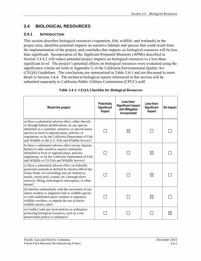
3.4 BIOLOGICAL RESOURCES
3.4.1 INTRODUCTION
This section describes biological resources (vegetation, fish, wildlife, and wetlands) in the
project area, identifies potential impacts on sensitive habitats and species that could result from
the implementation of the project, and concludes that impacts on biological resources will be less
than significant. Incorporation of the Applicant-Proposed Measures (APMs) described in
Section 3.4.4.2 will reduce potential project impacts on biological resources to a less-than-
significant level. The project’s potential effects on biological resources were evaluated using the
significance criteria set forth in Appendix G of the California Environmental Quality Act
(CEQA) Guidelines. The conclusions are summarized in Table 3.4-1 and are discussed in more
detail in Section 3.4.4. The technical biological reports referenced in this section will be
submitted separately to California Public Utilities Commission (CPUC) staff.
Table 3.4-1: CEQA Checklist for Biological Resources
Would the project: Potentially Significant
Impact
Less-than-Significant Impact
with Mitigation Incorporated
Less-than-Significant
Impact No Impact
a) Have a substantial adverse effect, either directly
or through habitat modifications, on any species
identified as a candidate, sensitive, or special-status
species in local or regional plans, policies, or
regulations, or by the California Department of Fish
and Wildlife or the U.S. Fish and Wildlife Service?
b) Have a substantial adverse effect on any riparian
habitat or other sensitive natural community
identified in local or regional plans, policies,
regulations, or by the California Department of Fish
and Wildlife or US Fish and Wildlife Service?
c) Have a substantial adverse effect on federally
protected wetlands as defined by Section 404 of the
Clean Water Act (including, but not limited to,
marsh, vernal pool, coastal, etc.) through direct
removal, filling, hydrological interruption, or other
means?
d) Interfere substantially with the movement of any
native resident or migratory fish or wildlife species
or with established native resident or migratory
wildlife corridors, or impede the use of native
wildlife nursery sites?
e) Conflict with any local policies or ordinances
protecting biological resources, such as a tree
preservation policy or ordinance?
Section 3.4 – Biological Resources
December 2015 Pacific Gas and Electric Company
3.4-2 Fulton-Fitch Mountain Reconductoring Project
Would the project: Potentially Significant
Impact
Less-than-Significant Impact
with Mitigation Incorporated
Less-than-Significant
Impact No Impact
f) Conflict with the provisions of an adopted Habitat
Conservation Plan, Natural Community
Conservation Plan, or other approved local, regional,
or state habitat conservation plan?
3.4.2 REGULATORY BACKGROUND AND METHODOLOGY
3.4.2.1 Regulatory Background
Federal
Endangered Species Act
The federal Endangered Species Act (ESA) of 1973 (16 United States Code [USC] 1531–1544),
as amended, protects plants, fish, and wildlife that are listed as endangered or threatened by the
U.S. Fish and Wildlife Service (USFWS) or the National Oceanic and Atmospheric
Administration’s National Marine Fisheries Service (NOAA Fisheries). Section 9 of the ESA
prohibits the “take” of listed fish and wildlife, where “take” is defined as “to harass, harm,
pursue, hunt, shoot, wound, kill, trap, capture, collect, or attempt to engage in such conduct”
(50 Code of Federal Regulations [CFR] 17.3). For plants, this statute prohibits removing,
possessing, maliciously damaging, or destroying any listed plant under federal jurisdiction and
removing, cutting, digging-up, damaging, or destroying any listed plant in knowing violation of
state law (16 USC 1538).
The ESA allows for issuance of incidental take permits to private parties either in conjunction
with a Habitat Conservation Plan (HCP) or as part of a Section 7 consultation (which is
discussed in the following paragraph). Under Section 10 of the ESA, a private party may obtain
incidental take coverage by preparing an HCP to cover target species within the project area,
identifying impacts to the covered species, and presenting the measures that will be undertaken
to avoid, minimize, and mitigate such impacts.
Under Section 7 of the ESA, federal agencies are required to consult with USFWS and/or NOAA
Fisheries, as applicable, if their actions—including permit approvals or funding—may affect a
federally listed species (including plants) or designated critical habitat. If the project is likely to
adversely affect a species, the federal agency will initiate formal consultation with the USFWS
and/or NOAA Fisheries and issue a biological opinion as to whether a proposed agency action(s)
is likely to jeopardize the continued existence of a listed species (jeopardy) or adversely modify
critical habitat (adverse modification). As part of the biological opinion, the USFWS may issue
an incidental take statement allowing take of the species that is incidental to an otherwise
authorized activity, provided that the action will not jeopardize the continued existence of the
species or adversely modify designated critical habitat.
Section 3.4 – Biological Resources
Pacific Gas and Electric Company December 2015 Fulton-Fitch Mountain Reconductoring Project 3.4-3
Migratory Bird Treaty Act
The Migratory Bird Treaty Act (MBTA) of 1918 (16 USC Sections 703–711) protects all
migratory birds, including active nests and eggs. Birds protected under the MBTA include all
native waterfowl, shorebirds, hawks, eagles, owls, doves, and other common birds such as
ravens, crows, sparrows, finches, swallows, and others, including their body parts (for example
feathers and plumes), active nests, and eggs. A complete list of protected species can be found in
50 CFR 10.13. Enforcement of the provisions of the federal MBTA is the responsibility of
USFWS.
Bald and Golden Eagle Protection Act
The Bald and Golden Eagle Protection Act (BGEPA) of 1940 (16 USC Section 668) specifically
protects bald and golden eagles and their nests from harm or trade in parts of these species. The
1972 amendments increased penalties for violating provisions of the BGEPA or regulations
issued pursuant thereto and strengthened other enforcement measures. Rewards are provided for
information leading to arrest and conviction for violation of the BGEPA.
Waters and Wetlands: Clean Water Act Sections 401 and 404
The purpose of the Clean Water Act (CWA) (33 USC Section 1251 et seq.) is to “restore and
maintain the chemical, physical, and biological integrity of the nation’s waters.” Waters of the
United States include rivers, streams, estuaries, the territorial seas, ponds, lakes, tributaries, and
adjacent wetlands. Wetlands are defined as those areas “that are inundated or saturated by
surface or ground water at a frequency and duration sufficient to support, and that under normal
circumstances do support, a prevalence of vegetation typically adapted for life in saturated soil
conditions” (33 CFR 328.3; 80 Fed. Reg. 37054).
The U.S. Army Corps of Engineers (USACE) issues permits for work in wetlands and other
waters of the United States based on guidelines established under Section 404 of the CWA.
Section 404 of the CWA prohibits the discharge of dredged or fill material into waters of the
United States, including wetlands, without a permit from the USACE. The USEPA also has
authority over wetlands and may, under Section 404(c), veto a USACE permit.
Section 401 of the CWA requires all Section 404 permit actions to obtain a state Water Quality
Certification or waiver, as described in more detail in Section 3.9, Hydrology and Water Quality.
State
California Endangered Species Act
Sections 2050–2098 of the California Fish and Game Code (the California Endangered Species
Act [CESA]) prohibit the take of state-listed endangered and threatened species unless
specifically authorized by the CDFW). The state definition of “take” is to hunt, pursue, catch,
capture, or kill a member of a listed species or attempt to do so. CDFW administers CESA and
authorizes take through permits or memorandums of understanding issued under Section 2081 of
CESA, or through a consistency determination issued under Section 2080.1. Section 2090 of
CESA requires state agencies to comply with threatened and endangered species protection and
recovery and to promote conservation of these species.
Section 3.4 – Biological Resources
December 2015 Pacific Gas and Electric Company
3.4-4 Fulton-Fitch Mountain Reconductoring Project
Fully Protected Species Under the Fish and Game Code
Fish and Game Code designates certain fish and wildlife species as “fully protected” under
Sections 3511 (birds), 4700 (mammals), 5050 (reptiles and amphibians), and 5515 (fish). Fully
protected species may not be taken or possessed at any time, and no permits may be issued to
Pacific Gas and Electric Company (PG&E) for incidental take of these species.1
Protection for Birds: Fish and Game Code
Fish and Game Code Section 3503 et seq. state that it is unlawful to take, possess, or needlessly
destroy the nest or eggs of any bird, except as otherwise provided by this code or any regulation
made pursuant thereto. Section 3503.5 makes it unlawful to take, possess, or destroy any birds in
the orders of Falconiformes or Strigiformes (birds of prey) or to take, possess, or destroy the nest
or eggs of any such bird.
Native Plant Protection Act of 1973
The Native Plant Protection Act of 1973 (Fish and Game Code Sections 1900–1913) includes
provisions that prohibit the taking of endangered or rare native plants. CDFW administers the
Native Plant Protection Act of 1973 and generally regards as rare many plant species included on
California Rare Plant Rank (CRPR) 1A, 1B, 2A, and 2B of the California Native Plant Society
(CNPS) (2011) Inventory of Rare and Endangered Vascular Plants of California. In addition,
sometimes CRPR 3 and 4 plants are considered if the population has local significance in the
area and is impacted by the project.
Section 1913(b) includes a specific provision to allow for the incidental removal of endangered
or rare plant species, if not otherwise salvaged by CDFW, within a right-of-way to allow a public
utility to fulfill its obligation to provide service to the public.
California Species of Special Concern
Species of Special Concern (SSC) is a category conferred by CDFW to fish and wildlife species
that meet the state definition of threatened or endangered, but have not been formally listed (e.g.,
federally or state-listed species), or are considered at risk of qualifying for threatened or
endangered status in the future based on known threats. SSC is an administrative classification
only, but these species should be considered “special-status” for the purposes of the CEQA
analysis (see the Significance Criteria section of this document).
Porter-Cologne Water Quality Control Act
The State Water Resources Control Board (SWRCB) and the nine Regional Water Quality
Control Boards (RWQCBs) have jurisdiction over all surface water and groundwater in
California, including wetlands, headwaters, and riparian areas. The SWRCB or applicable
RWQCB must issue waste discharge requirements for any activity that discharges waste that
could affect the quality of waters of the state, as described in more detail in Section 3.9,
Hydrology and Water Quality.
1 While take of fully protected species may be authorized by CDFW under a Natural Communities Conservation Plan (NCCP),
PG&E activities are not covered by an NCCP, so this permitting option is not available.

Section 3.4 – Biological Resources
Pacific Gas and Electric Company December 2015 Fulton-Fitch Mountain Reconductoring Project 3.4-5
Local
This section includes a summary of local or regional plans, policies, or regulations that identify
sensitive or special-status species in the project area, as well as local polices or ordinances that
protect biological resources. Because the CPUC has exclusive jurisdiction over the siting,
design, and construction of the project, the project is not subject to local discretionary regulations
related to biological resources. The following summary is provided for informational purposes
and to assist with CEQA review.
Santa Rosa Plain Conservation Strategy
The purpose of the Santa Rosa Plain Conservation Strategy (USFWS 2005) is to create a long-
term conservation program sufficient to mitigate potential adverse effects on listed species due to
future development on the Santa Rosa Plain. The program will contribute to the recovery of the
Sonoma County distinct population segment of California tiger salamander (CTS) (Ambystoma
californiense), and Burke’s goldfields (Lasthenia burkei), Sonoma sunshine (Blennosperma
bakeri), Sebastopol meadowfoam (Limnanthes vinculans), and many-flowered navarretia
(Navarretia leucocephala ssp. plieantha) (listed plants), and to the conservation of their sensitive
habitat. The Conservation Strategy accomplishes these goals in a manner that protects
stakeholders’ (both public and private) land use interests, and supports issuance of an
authorization for incidental take of CTS and listed plants that may occur in the course of carrying
out covered activities on the plain.
Sonoma County General Plan Policy for Riparian Corridors
In 2008, the Board of Supervisors adopted General Plan 2020, which increased protections for
riparian corridors. In November 2014, the Board of Supervisors adopted zoning code changes to
implement the stream protection policies, and rezoned properties to add the Riparian Corridor
Combining Zone to all designated streams shown on the General Plan Open Space maps.
Sonoma County defines a riparian corridor as the area occupied by a river or stream and related
plant or animal communities. Riparian corridors provide numerous benefits to the community
and the environment, including improving water quality; increasing groundwater recharge;
providing flood protection; enhancing wildlife and aquatic habitat; and supporting the recovery
of salmon, steelhead, and other endangered species.
Tree Protection Ordinances
Sonoma County has a Valley Oak Conservation Plan that protects this species within the Valley
Oak Habitat Combining District (Article 67 of the Sonoma County Zoning Regulations).
Mitigation for removal of large valley oak with diameter at breast height (dbh) greater than 20
inches or small valley oaks with a cumulative dbh greater than 60 inches includes replanting or
paying an in-lieu fee to the County valley oak planting program. The landowner has the sole
discretion to choose the mitigation measure, which must be undertaken and completed within 1
year.
The Sonoma County Heritage of Landmark Tree Ordinance (Sonoma County Code, Chapter
26D) protects heritage or landmarks trees or groves of trees that are designated by the Sonoma

Section 3.4 – Biological Resources
December 2015 Pacific Gas and Electric Company
3.4-6 Fulton-Fitch Mountain Reconductoring Project
County board of supervisors. “Heritage tree” means a designated tree or grove of trees with
historical interest or significance. “Landmark tree” means a designated tree or grove of trees that
possesses outstanding characteristics in terms of size, age, rarity, shape, or location. Removal of
trees by a CPUC-licensed utility in order to maintain required clearance around power lines is
exempted from the ordinance, and no permit is required for trimming or pruning protected trees.
The Town of Windsor’s Tree Preservation and Protection Ordinance (Chapter 27.36, Zoning
Ordinance) regulates protection, preservation, maintenance, and removal of protected trees, as
specified in the ordinance. Removal of trees for the protection of existing electrical power lines
is exempted from the ordinance, and no permit is required for trimming or pruning protected
trees.
3.4.2.2 Methodology
This section summarizes the methods used to identify and analyze potential impacts on special-
status species that may occur in the project area. As described below, biologists began their
research with database searches and literature reviews to determine which special-status plants,
natural communities, and wildlife might have potential to occur in the project area. Using this
information, the biologists conducted detailed field surveys of the biological resources survey
area, as defined below. A more detailed description of these methods is provided in the project’s
Biological Resources Technical Report and Addendum, which will be provided separately to
CPUC staff.
Species Considered to be of Special Status
Special-status species include those that are:
Listed or candidates for listing as rare, threatened, or endangered under the federal ESA or
California ESA
Plants included in the online version of the CNPS Inventory of Rare and Endangered Plants
of California as CRPR 1A, 1B, 2A, or 2B
Fish or wildlife designated as a Species of Special Concern or a fully protected species by the
CDFW
Migratory birds with active nests, defined as containing eggs or dependent young
Natural communities were considered to be special-status if they were identified on the most
recent CDFW List of Vegetation Alliances and Associations as being highly imperiled.
Database Searches
The following biological databases were queried for records of special-status plants, natural
communities, and wildlife that might have potential to occur in the project area:
USFWS list of federally listed and proposed endangered, threatened, and candidate species
and their designated critical habitat (USFWS 2011)
Section 3.4 – Biological Resources
Pacific Gas and Electric Company December 2015 Fulton-Fitch Mountain Reconductoring Project 3.4-7
CNPS online Inventory of Rare and Endangered Vascular Plants of California (CNPS 2011)
California Natural Diversity Database (CNDDB) (CDFG 2011)
The CNDDB search area included a “nine-quad” search, including the U.S. Geological Survey
(USGS) 7.5-minute quadrangle (quad) in which the project is located (Healdsburg), and the eight
surrounding quads (Camp Meeker, Geyserville, Guerneville, Jimtown, Mark West Springs,
Mount St. Helena, Santa Rosa, and Sebastopol).
The USFWS database was queried using a custom polygon that encompassed the project area.
Other information sources consulted to determine which special-status species could potentially
occur in the project area included:
Santa Rosa Plain Conservation Strategy (USFWS 2005) for information related to the
occurrence of CTS, Burke’s goldfields, Sonoma sunshine, Sebastapol meadowfoam, and
many-flowered navarretia
Soil maps (Natural Resources Conservation Service [NRCS] 2011)
CDFW’s List of Vegetation Alliances and Associations
A Manual of California Vegetation (Sawyer et al. 2009)
Aerial photographs
Jepson Manual, Second Edition: Vascular Plants of California (Baldwin et al. 2012)
A Flora of Sonoma County (Best et al. 1996)
Sonoma County Breeding Bird Atlas (Burridge 1995)
CalPhotos database (UC Berkeley 2011)
California State University, Chico and University of California, Davis herbaria
Species experts
Field Surveys
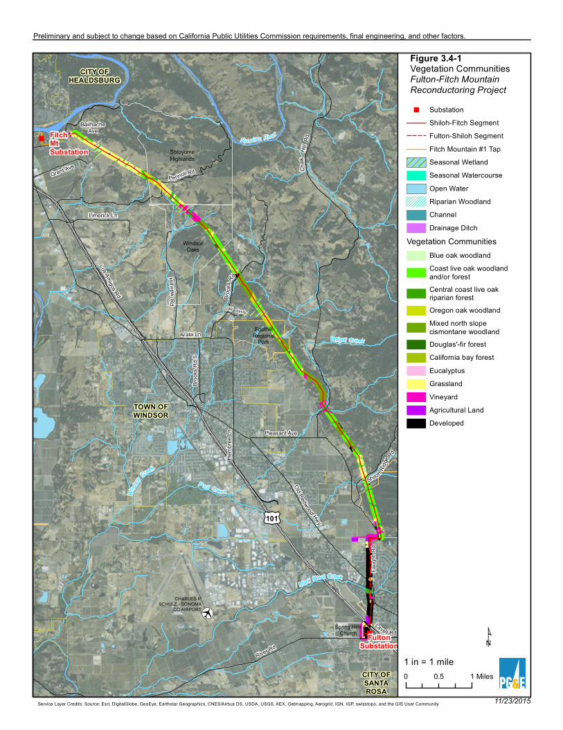
The biological resources survey area included a 500-foot-wide corridor extending 250 feet on
either side of the project alignment (Figure 3.4-1[a–e]: Vegetation Communities). In addition to
this corridor, the survey area included access routes and landing zones/staging areas that fall
outside of the 500-foot corridor around the alignment. At these locations, an additional 50-foot-
wide buffer was surveyed to allow flexibility for minor adjustments during construction. The
survey area was surveyed on foot, except for steep canyons where access was unsafe, and where
equipment access would not be feasible during construction. Existing substations, which were
previously improved and covered with compacted fill, were not surveyed for biological
resources.
[·
"
"
BailhacheAve
Hemb
ree Ln
Bro o
ksRd
Shiloh Ridge
Rd
Pleasant Ave
River Rd
Old Redwood Hwy
Grant Ave
Arata Ln
Mt WeskeDr
Hillvie wRd
Lavell Rd
Faug
ht Rd
Broo
ks R
d S
Limerick Ln
Chalk
Hill R
d
Los Amigos Rd
Perinoli Rd
£¤101
FultonSubstation
FitchMtSubstation
Russian Riv er
Mark West Creek
Pool CreekWinds
or
Creek
Wright Creek
TOWN OFWINDSOR
CITY OFHEALDSBURG
CITY OFSANTAROSA
FoothillRegional
Park
SotoyomeHighlands
WindsorOaks
Spring HillsChurch
CHARLES MSCHULZ - SONOMA
CO AIRPORT
0 10.5 Miles
¹
11/23/2015Service Layer Credits: Source: Esri, DigitalGlobe, GeoEye, Earthstar Geographics, CNES/Airbus DS, USDA, USGS, AEX, Getmapping, Aerogrid, IGN, IGP, swisstopo, and the GIS User Community
Figure 3.4-1Vegetation CommunitiesFulton-Fitch Mountain Reconductoring Project" Substation
Shiloh-Fitch SegmentFulton-Shiloh SegmentFitch Mountain #1 TapSeasonal WetlandSeasonal WatercourseOpen WaterRiparian WoodlandChannelDrainage Ditch
Vegetation CommunitiesBlue oak woodlandCoast live oak woodlandand/or forestCentral coast live oakriparian forestOregon oak woodlandMixed north slopecismontane woodlandDouglas'-fir forestCalifornia bay forestEucalyptusGrasslandVineyardAgricultural LandDeveloped
Preliminary and subject to change based on California Public Utilities Commission requirements, final engineering, and other factors.
1 in = 1 mile
Section 3.4 – Biological Resources
Pacific Gas and Electric Company December 2015 Fulton-Fitch Mountain Reconductoring Project 3.4-9
Reconnaissance Surveys
General biological reconnaissance surveys entailed walking and meandering transects in the
biological resources survey area (as defined previously), and surveying areas that appeared to
support special-status fauna and flora, as identified in desktop-level reviews.
The following tasks were conducted during the reconnaissance-level surveys:
Plant communities and habitat types were identified in the biological resources survey area
and evaluated for special-status plant suitability in April 2011, March 2015, and October
2015. The April 2011 biological resource survey included the northern Shiloh-Fitch
segment, spanning from Healdsburg to Shiloh Ranch Regional Park. The March 2015
biological resource survey included the southern Fulton-Shiloh segment, spanning from
Shiloh Ranch Regional Park to Fulton Substation. The October 2015 survey included
identification of water crossings on access roads for the Shiloh-Fitch segment.
Field reconnaissance surveys for suitable habitat for special-status wildlife species were
conducted within the biological resources survey area on August 15 and 16, 2011. A
separate reconnaissance survey was done on March 31, 2015, within the portion of the
project area that was added after the 2011 surveys. The purpose of these surveys was to
identify and describe on-site habitat conditions, and assess habitat suitability for potential
occurrence of special-status wildlife species.
Focused Surveys
Focused surveys evaluate habitat in the project area and its ability to support relevant special-
status species. Species-specific focused surveys were initiated once it was determined that
suitable habitat exists in the biological resources survey area for California red-legged frog
(CRLF) (Rana draytonii). In February 2012, biologists conducted a survey for potential habitat
suitable for CRLF within the biological resources survey area; in 2015, biologists addressed the
potential for CRLF at access road water crossings. In 2015, raptor surveys were conducted from
March through May. In July 2015, bat surveys were conducted.
Protocol-Level Surveys
Protocol surveys are species-specific surveys that follow agency-issued guidelines and determine
the presence or absence of these species. Protocol-level surveys for special-status plants—using
CDFW, USFWS, and Bureau of Land Management protocols—were conducted in suitable
habitat locations in the biological resources survey area by a team of botanists on April 19–22,
May 10–12, June 6–9, and June 24, 2011. A second season of surveys was performed on April
18–19, and June 14–15, and 20, 2012. To assess project impacts, mapped locations of special-
status plants were overlain with project features.
During surveys, special attention was given to the identification of seasonal wetland and vernal
pool habitats that might be suitable for listed plant species, identified in the Santa Rosa Plain
Conservation Strategy (USFWS 2005) as occurring on the Santa Rosa Plain.
A jurisdictional delineation was conducted on November 2, 2012. Wetland areas within the
project footprint were assessed, and representative data points were collected to determine the

Section 3.4 – Biological Resources
December 2015 Pacific Gas and Electric Company
3.4-10 Fulton-Fitch Mountain Reconductoring Project
extent of wetland boundaries. The delineation included a complete list of plant species observed
within the delineated wetlands.
Likelihood of Presence for Special-Status Species
Using the information generated from literature reviews and field surveys, the list of special-
status species with the potential to occur was further refined to reflect the species that may occur
within the project area. The likelihood of special-status species occurrence was determined
based on natural history parameters, including but not limited to, the species’ range, habitat,
foraging needs, migration routes, and reproductive requirements, using the following general
categories:
Present: Reconnaissance-level, focused, or protocol-level surveys documented the
occurrence or observation of a species in the project area.
Seasonally present: Individuals were observed in the project area only during certain times of
the year.
Likely to occur (on site): The species has a strong likelihood to be found in the project area
prior to or during construction but has not been directly observed to date during project
surveys. The likelihood that a species may occur is based on the following considerations:
suitable habitat that meets the life history requirements of the species is present on or near the
project area; migration routes or corridors are near or within the project area; records of
sighting are documented on or near the project area; and there is an absence of invasive
predators (e.g., bullfrogs). The main assumption is that records of occurrence have been
documented within or near the project area, the project area falls within the range of the
species, and suitable habitat is present, but it is undetermined whether the habitat is currently
occupied.
Potential to occur: There is a possibility that the species can be found in the project area
prior to or during construction, but has not been directly observed to date. The likelihood
that a species may occur is based on the following conditions: suitable habitat that meets the
life history requirements of the species is present on or near the project area; migration routes
or corridors are near or within the project area; and there is an absence of invasive predators
(e.g., bullfrogs). The main assumption is that the project area falls within the range of the
species and suitable habitat is present, but no records of sighting are located within or near
the project area and it is undetermined whether the habitat is currently occupied.
Unlikely to occur: The species is not likely to occur in the project area based on the following
considerations: lack of suitable habitat and features that are required to satisfy the life history
requirements of the species (e.g., absence of foraging habitat; lack of reproductive areas, and
lack of sheltering areas); presence of barriers to migration/dispersal; presence of predators or
invasive species that inhibit survival or occupation (e.g., the presence of bullfrogs or invasive
fishes); lack of hibernacula, hibernation areas, or estivation areas on site.
Section 3.4 – Biological Resources
Pacific Gas and Electric Company December 2015 Fulton-Fitch Mountain Reconductoring Project 3.4-11
Absent: Suitable habitat does not exist in the project area, the species is restricted to or
known to be present only within a specific area outside of the project area, or focused or
protocol-level surveys did not detect the species.
Unless otherwise noted, the methodology and environmental information presented in this
section are summarized from the Biological Resources Technical Report for the Fulton-Fitch 60
kV Power Line Reconductoring Project and Addendum, which will be provided separately to
CPUC staff.
3.4.3 ENVIRONMENTAL SETTING
3.4.3.1 Regional
Regional plant communities in the project area include those that are common to the northern
California coast, including mixed oak woodland, Douglas-fir forest, grasslands, and riparian
forest. Areas developed for agricultural or other human use are interspersed within the natural
communities. The climate is typically mild and influenced by coastal fog in the summer. The
region is situated in the Northern Coast Ranges, and elevations range from approximately 30 to
1,000 feet above sea level.
Landcover, Vegetation, and Wildlife Habitats
The project area supports a diversity of vegetation communities, including oak woodland,
grassland, and forest. A brief description of each type is presented in the following paragraphs,
from most common to least common.
Coast Live Oak Woodland and Coast Live Oak Forest
The most common vegetation communities in the project area are coast live oak woodland and
coast live oak forest. These are the dominant community types on the foothills above the valley
floor. In both types, the canopy is dominated by coast live oak (Quercus agrifolia). Other tree
species—such as madrone (Arbutus menziesii), blue oak (Quercus douglasii), Oregon oak
(Quercus garryana ssp. garryana), and California bay (Umbellularia californica)—are also
common. California buckeye (Aesculus californicus) is also occasionally present, while poison
oak (Toxicodendron diversilobum), and pink honeysuckle (Lonicera hispidula var. vacillans) are
common woody plants in the understory.
The coast live oak woodland has an intermittent canopy with a grassy, open understory. A
variety of grasses and herbs grow in the openings between trees and at the woodland edge.
Common species are slender wild oat (Avena barbata), rattlesnake grass (Briza maxima), wavy-
leaf soaproot (Chlorogalum pomeridianum), hedgehog dogtail (Cynosurus echinatus), blue
wildrye (Elymus glaucus), purple needlegrass (Stipa pulchra), and common hedge parsley
(Torilis arvensis).
The coast live oak forest has similar species composition, but has more of a closed canopy, with
fewer openings that support herbaceous species. These two communities intergrade with each
other, Oregon oak woodland, and mixed north slope cismontane woodland.
Section 3.4 – Biological Resources
December 2015 Pacific Gas and Electric Company
3.4-12 Fulton-Fitch Mountain Reconductoring Project
Grasslands
Grasslands are the second most common vegetation community in the project area. These
grasslands consist of areas dominated by low-growing grasses and herbs, with few trees and/or
shrubs. Common species in the grasslands are Spanish lotus (Acmispon americanus), barbed
goatgrass (Aegilops triuncialis), slender wild oat, purple false brome (Brachypodium
distachyon), rattlesnake grass, ripgut brome (Bromus diandrus), soft chess (Bromus hordeaceus),
sterile brome (Bromus sterilis), hedgehog dogtail, medusahead (Elymus caput-medusae), blue
wildrye, stork’s-bills (Erodium botrys), six weeks rattail fescue (Festuca myuros), rye grass
(Festuca perennis), Harding grass (Phalaris aquatica), purple needlegrass, little hop clover
(Trifolium dubium), and rose clover (Trifolium hirtum). Some areas support non-dominant
native wildflowers such as clarkias (Clarkia sp.), lupines (Lupinus sp.), and phloxes
(Leptosiphon sp.).
Mixed North Slope Cismontane Woodland
Mixed north slope cismontane woodland is also a common vegetation community in the project
area. The same tree species are present in the overstory of this woodland as in coast live oak
woodland, including California buckeye, madrone, coast live oak, blue oak, garry oak, and
California bay. California black oak (Quercus kelloggii) and gray pine (Pinus sabiniana) are
also present. Common shrubs in the understory include common manzanita (Arctostaphylos
manzanita), coyote brush (Baccharis pilularis), pink honeysuckle, snowberry (Symphoricarpos
mollis), and poison oak. The herbaceous layer in this mixed woodland is similar to that of the
coast live oak woodland.
Oregon Oak Woodland
Oregon oak woodland is less common in the project area. Dominant trees include Oregon oak,
California buckeye, madrone, coast live oak, and blue oak. Poison oak, hairy honeysuckle, and
snowberry are common woody plants in the understory. The herbaceous layer contains grasses
and herbs also common in the north slope cismontane woodland and grasslands.
Vineyard
Cultivated grape (Vitis vinifera) vineyards are present throughout the project area. Vineyards are
managed with even-aged grape vines and a mowed ruderal understory. Common understory
species are wild oat, soft chess, ripgut brome, rough cat’s-ear (Hypochaeris radicata), various
types of filaree, black medic (Medicago lupulina), English plantain (Plantago lanceolata), little
hop clover, rose clover, and subterranean clover (Trifolium subterraneum).
Central Coast Live Oak Riparian Forest
Central Coast live oak riparian forest occurs in the corridors around larger perennial streams.
Coast live oak is a dominant tree in the dense overstory of these corridors. Unlike the coast live
oak woodlands and forests in the drier settings described previously, these riparian forests have a
more evenly mixed canopy containing broad-leaved and riparian trees such as big-leaf maple
(Acer macrophyllum), California buckeye, valley oak (Quercus lobata), interior live oak
(Quercus wislizenii), red willow (Salix laevigata), and arroyo willow (Salix lasiolepis). In these
settings, the canopy is dense, multi-storied, and tall, often to 50 feet. Blackberry (Rubus
armeniacus, Rubus ursinus), snowberry, and poison oak are common in the understory. The
streams have a mix of hydrophytic herbs such as tall nutsedge (Cyperus eragrostis), dense
Section 3.4 – Biological Resources
Pacific Gas and Electric Company December 2015 Fulton-Fitch Mountain Reconductoring Project 3.4-13
willow-herb (Epilobium densiflorum), pennyroyal (Mentha pulegium), seep-spring
monkeyflower (Mimulus guttatus), rabbit’s foot grass (Polypogon monspeliensis), and the moss
Scleropodium (on rocks below ordinary high water).
Developed Areas
A portion of the survey area (approximately 6 acres) is developed as residential homes with
driveways and other paved surfaces, yards, gardens, barns, tennis courts, small orchards, and
similar non-natural environments.
Wetlands and Aquatic Resources
Wetland types and water features observed in the project area are described in detail in the
following paragraphs.
Seasonal Watercourses
The project alignment intersects numerous watercourses. Two types of seasonal watercourses—
ephemeral channels and intermittent creeks—were observed within the project area. Ephemeral
channels within the project area are those seasonal drainages that support flowing water for brief
periods during precipitation events. Ephemeral channels can include unvegetated waterways or
watercourses with vegetative communities along the banks or channel, which are contiguous
with the surrounding upland communities (e.g., ruderal or non-native grassland within the
channel bed and banks). Intermittent creeks are defined as those seasonal drainages where both
rainwater and groundwater flow during the wet season, sometimes extending into late spring or
early summer. Intermittent creeks typically support some wetland or riparian vegetation within
or surrounding the banks. For the purpose of mapping for this project, the two drainage types are
mapped together as seasonal watercourses.
Open Water
In the project area, the mapped open water includes unvegetated standing waters, including two
man-made ponds located on private property. Generally, the depth of the project area's open
waters precludes establishment of emergent vegetation; however, mosquito fern (Azolla sp.)
provides a thick surface cover.
Seasonal Wetland
Seasonal wetlands occur in depressions, ditches, swales, and other low-lying areas that are
inundated or support saturated soil conditions for a portion of the growing season. Soil
conditions within seasonal wetlands are generally dry in late summer through fall. These
wetlands are usually supported by direct precipitation and/or overland flow during the wet
season. The vegetation composition and structure of seasonal wetlands is highly variable
depending on soil type, hydrology, and disturbance levels. These sites are generally dominated
by annual species, but may include some perennial species, depending on local hydrology.
Common plants in seasonal wetlands within the project area include ryegrass, Harding grass,
rushes (Juncus bufonius, J. effusus, J. occidentalis, J. patens, and J. xiphioides), curly dock
(Rumex crispus), hyssop loosestrife (Lythrum hyssopifolia), pennyroyal, oxtongue
(Helminthotheca echioides), wild hyacinth (Triteleia hyacinthina), and vernal sweet grass
(Anthoxanthum odoratum). Regular disturbance by cattle has resulted in establishment of non-
native species and invasive exotics in the wetland depressions. However, ponding was observed

Section 3.4 – Biological Resources
December 2015 Pacific Gas and Electric Company
3.4-14 Fulton-Fitch Mountain Reconductoring Project
at the time of the 2011 and 2012 surveys, suggesting that conditions are suitable for seasonal
wetlands, if they are not regularly disturbed.
Seasonal wetlands are widely distributed through the project area and are found in both natural
and man-made settings. In many locations, seasonal watercourses expand into broad terraces
that support characteristic seasonal wetland vegetation, and are mapped based on the wetland
community type. Additionally, in some locations where overland stormwater runoff accumulates
prior to passing into the watercourse, seasonal wetlands have developed adjacent to seasonal and
perennial watercourses and open water. Seasonal wetlands are also present within and adjacent
to access roads, in a small ditch within grassland habitat, and surrounding one pole where
seasonal precipitation accumulates in sufficient quantity and duration within disturbed areas to
support wetland vegetation.
Riparian Woodland
The riparian woodland community tree canopy ranges from continuous to intermittent over the
associated stream course (perennial and intermittent creeks). Riparian tree cover can replace or
complement shrub cover associated with riparian scrubs. Within the project area, the tree canopy
of riparian woodlands is dominated by coast live oak, interior live oak, and/or valley oak, with
tree willows such as arroyo willow and red willow, big-leaf maple, California buckeye, and
California bay. Riparian woodlands were identified along watercourses throughout the project
area.
Special-Status Species
This section describes special-status species observed (present) during project reconnaissance-
level field surveys and any species considered to be likely to occur, have potential to occur, or
that are seasonally present. Special-status species that are unlikely to be found in the project area
are not discussed in this section.
Special-Status Plants
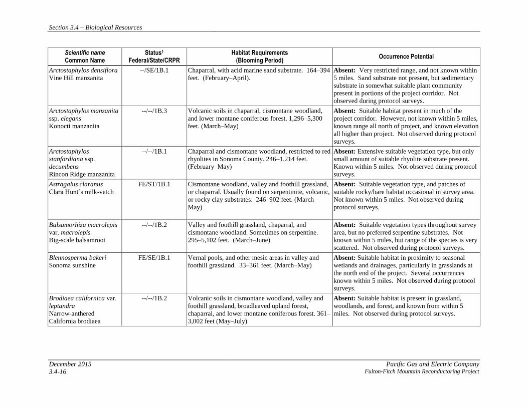
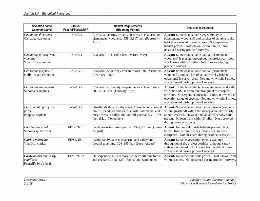
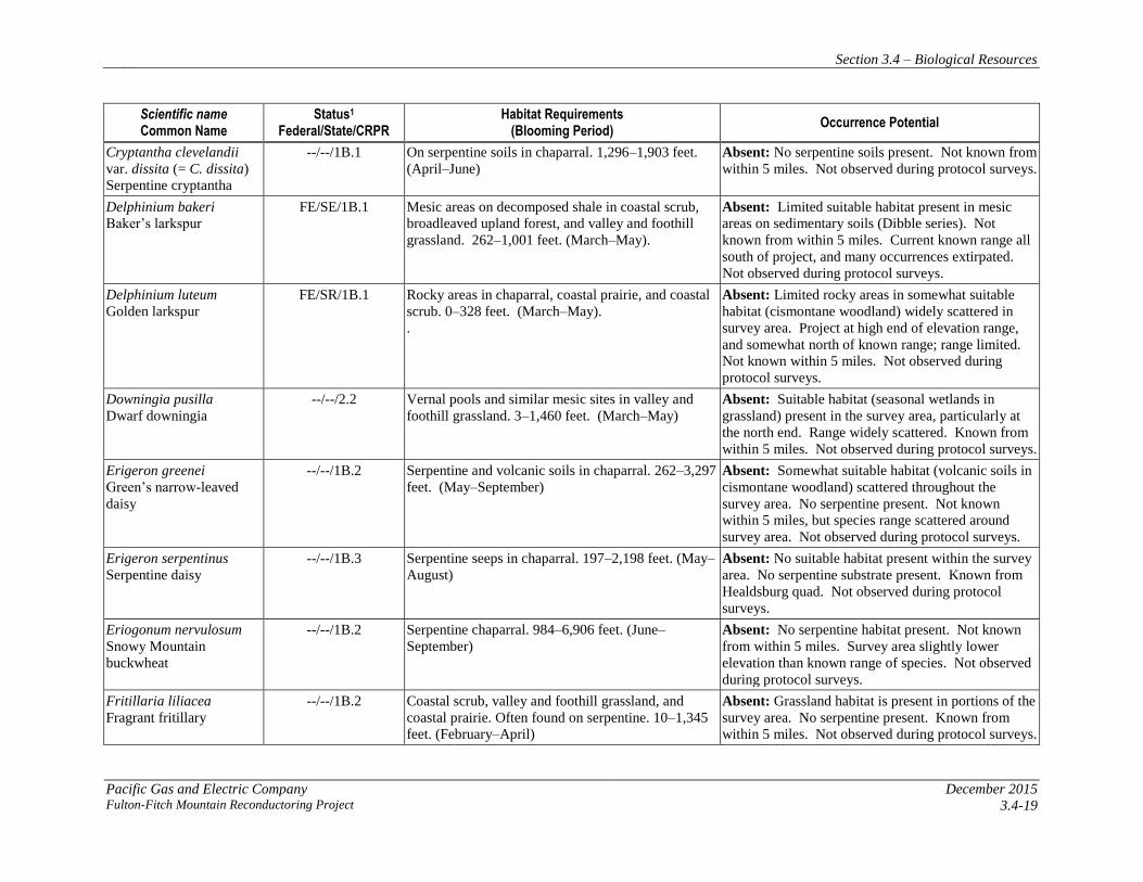
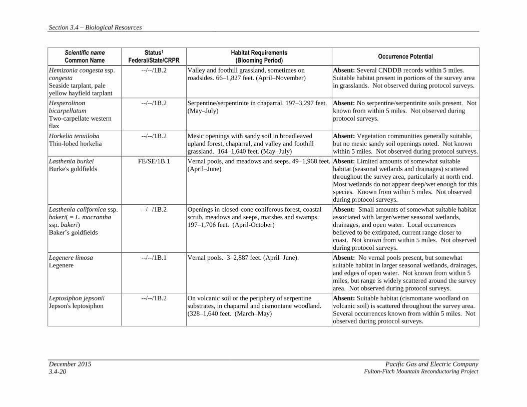
Background research identified 66 special-status plant species from the nine-quad search area
(Table 3.4-2: Special-Status Plant Species). However, no federal- or state-listed or CRPR List 1
or 2 plant species were observed in the plant survey area during the protocol level surveys
conducted in 2011 and 2012. Suitable habitat for covered plant species is absent in those
portions of the plant survey area that lie within the boundary of the Santa Rosa Plain
Conservation Strategy (USFWS 2005).
Several weed species that are listed by the California Department of Food and Agriculture and/or
the California Invasive Pest Council were observed during surveys. Noxious weeds observed
during the surveys include barbed goatgrass, medusahead, Italian thistle (Carduus
pyncnocephalus), purple star-thistle (Centaurea calcitrapa), yellow star-thistle (Centaurea
solstitialis), Scotch broom (Cytisus scoparius), French broom (Genista monspessulana), and
Spanish broom (Spartium junceum).

Section 3.4 – Biological Resources
Pacific Gas and Electric Company December 2015 Fulton-Fitch Mountain Reconductoring Project 3.4-15
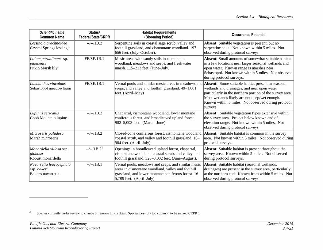
Table 3.4-2: Special-Status Plant Species
Scientific name Common Name
Status1 Federal/State/CRPR
Habitat Requirements (Blooming Period)
Occurrence Potential
Alopecurus aequalis var.
sonomensis
Sonoma alopecurus FE/--/1B.1
Freshwater marshes and swamps, riparian scrub. 16–
1,197 feet. (May–July)
Absent: A small amount of moderately suitable
habitat is present along the portions of the project
located in proximity to wetter streams, and ponds. No
occurrences known within 5 miles. Not observed
during protocol surveys.
Amorpha californica var.
napensis
Napa false indigo
--/--/1B.2
Chaparral, cismontane woodland, and openings in
broadleaved upland forest. 394–6,562 feet. (April–
July)
Absent: Suitable habitat is present along most of the
project corridor and occurrence records are known
from within 5 miles. Not observed during protocol
surveys.
Amsinckia lunaris
Bent-flowered fiddleneck --/--/1B.2
Cismontane woodland, valley and foothill grassland,
coastal scrub. 10–1,640 feet. (March-June)
Absent: Suitable habitat present along most of the
project corridor but no occurrence records are known
within 5 miles. Not observed during protocol surveys.
Anomobryum julaceum
Slender silver moss --/--/2.2
Damp rock and soil on outcrops or roadcuts, in
broadleaved upland forest, lower montane coniferous
forest, north coast coniferous forest. 328–3,280 feet.
Absent: Suitable habitat only in a few limited areas of
the project corridor. No occurrence records within 5
miles. Not observed during protocol surveys.
Arctostaphylos bakeri ssp.
bakeri
Baker’s manzanita
--/SR/1B.1
Broadleaved upland forest, chaparral, often on
serpentine. 246–984 feet. (February–April)
Absent: No preferred serpentine habitat present, but
plenty of broadleaved upland forest on volcanic soils.
Not known within 5 miles. Not observed during
protocol surveys.
Arctostaphylos bakeri ssp.
sublaevis
The Cedars manzanita
--/SR/1B.2
Serpentine seeps in chaparral and closed-cone
coniferous forest. 607–2,493 feet. (February–May)
Absent: No serpentine habitat present. Not known
within 5 miles. Very restricted range, all to the west
of the project. Not observed during protocol surveys.
Arctostaphylos canescens
ssp. sonomensis
Sonoma canescent
manzanita
--/--/1B.2 Chaparral, lower montane coniferous forest.
Sometimes serpentine. 590–5,485 feet. (January–
June)
Absent: No preferred serpentine habitat, and no
conifer forest or chaparral. However, mixed north
slope woodland which may provide habitat present in
large portions of survey area. Known within 5 miles.
Not observed during protocol surveys.
Section 3.4 – Biological Resources
December 2015 Pacific Gas and Electric Company
3.4-16 Fulton-Fitch Mountain Reconductoring Project
Scientific name Common Name
Status1 Federal/State/CRPR
Habitat Requirements (Blooming Period)
Occurrence Potential
Arctostaphylos densiflora
Vine Hill manzanita
--/SE/1B.1 Chaparral, with acid marine sand substrate. 164–394
feet. (February–April).
Absent: Very restricted range, and not known within
5 miles. Sand substrate not present, but sedimentary
substrate in somewhat suitable plant community
present in portions of the project corridor. Not
observed during protocol surveys.
Arctostaphylos manzanita
ssp. elegans
Konocti manzanita
--/--/1B.3 Volcanic soils in chaparral, cismontane woodland,
and lower montane coniferous forest. 1,296–5,300
feet. (March–May)
Absent: Suitable habitat present in much of the
project corridor. However, not known within 5 miles,
known range all north of project, and known elevation
all higher than project. Not observed during protocol
surveys.
Arctostaphylos
stanfordiana ssp.
decumbens
Rincon Ridge manzanita
--/--/1B.1 Chaparral and cismontane woodland, restricted to red
rhyolites in Sonoma County. 246–1,214 feet.
(February–May)
Absent: Extensive suitable vegetation type, but only
small amount of suitable rhyolite substrate present.
Known within 5 miles. Not observed during protocol
surveys.
Astragalus claranus
Clara Hunt’s milk-vetch
FE/ST/1B.1 Cismontane woodland, valley and foothill grassland,
or chaparral. Usually found on serpentinite, volcanic,
or rocky clay substrates. 246–902 feet. (March–
May)
Absent: Suitable vegetation type, and patches of
suitable rocky/bare habitat occasional in survey area.
Not known within 5 miles. Not observed during
protocol surveys.
Balsamorhiza macrolepis
var. macrolepis
Big-scale balsamroot
--/--/1B.2 Valley and foothill grassland, chaparral, and
cismontane woodland. Sometimes on serpentine.
295–5,102 feet. (March–June)
Absent: Suitable vegetation types throughout survey
area, but no preferred serpentine substrates. Not
known within 5 miles, but range of the species is very
scattered. Not observed during protocol surveys.
Blennosperma bakeri
Sonoma sunshine
FE/SE/1B.1 Vernal pools, and other mesic areas in valley and
foothill grassland. 33–361 feet. (March–May)
Absent: Suitable habitat in proximity to seasonal
wetlands and drainages, particularly in grasslands at
the north end of the project. Several occurrences
known within 5 miles. Not observed during protocol
surveys.
Brodiaea californica var.
leptandra
Narrow-anthered
California brodiaea
--/--/1B.2 Volcanic soils in cismontane woodland, valley and
foothill grassland, broadleaved upland forest,
chaparral, and lower montane coniferous forest. 361–
3,002 feet (May–July)
Absent: Suitable habitat is present in grassland,
woodlands, and forest, and known from within 5
miles. Not observed during protocol surveys.

Section 3.4 – Biological Resources
Pacific Gas and Electric Company December 2015 Fulton-Fitch Mountain Reconductoring Project 3.4-17
Scientific name Common Name
Status1 Federal/State/CRPR
Habitat Requirements (Blooming Period)
Occurrence Potential
Calamagrostis
crassiglumis
Thurber's reed grass
--/--/2.1 Mesic areas in coastal scrub, and freshwater marsh.
Usually found in marshy swales. 33–148 feet.
(May–July)
Absent: Small amounts of slightly suitable habitat are
present of the project located in proximity to
drainages, seasonal wetlands, and open water. Known
occurrences in valleys or coastal. Not known within 5
miles. Not observed during protocol surveys.
Campanula californica
Swamp harebell
--/--/1B.2 Bogs and fens, meadows and seeps, freshwater
marsh, and other freshwater mesic habitats. Can
include areas in closed-cone coniferous forest,
coastal prairie, North Coast coniferous forest. 3–
1,329 feet. (June–October)
Absent: Small amounts of suitable habitat are located
in proximity to drainages, streams, and open water.
No occurrences from the background research within
5 miles, and thought to be extirpated from the area.
Most known occurrences are west of survey area. Not
observed during protocol surveys.
Carex albida
White sedge
FE/SE/1B.1 Freshwater marsh, and bogs and fens. 49–295 feet.
(May–July)
Absent: Small amounts of somewhat suitable habitat
are present along the portions of the project located in
proximity to streams, seasonal wetlands, drainages,
and open water. Only one extant occurrence is known
from Pitkin Marsh, which is more than 5 miles from
the survey area. Not observed during protocol
surveys.
Carex comosa
Bristly sedge
--/--/2.1 Mesic areas such as freshwater marshes and swamps,
and areas in valley and foothill grassland, and coastal
prairie. 0–2,050 feet. (May–September)
Absent: Small amounts of slightly suitable habitat are
present of the project, located in proximity to streams,
drainages, seasonal wetlands, and open water. Not
known within 5 miles. Not observed during protocol
surveys.
Castilleja uliginosa
Pitkin Marsh Indian
paintbrush
--/SE/1.A Freshwater marshes and swamps (June–July) Absent: Small amounts of slightly suitable habitat are
present along the portions of the project located in
proximity to streams, drainages, seasonal wetlands,
and open water. Thought to be extirpated from last
known occurrence at Pitkin Marsh, which is more
than 5 miles from the survey area. Not observed
during protocol surveys.
Ceanothus confusus
Rincon Ridge ceanothus
--/--/1B.1 Serpentine or volcanic soils in closed-cone
coniferous forest, chaparral, and cismontane
woodland. 246–3,494 feet. (February–June)
Absent: Although serpentine substrates not present,
generally suitable habitat (cismontane woodland with
volcanic soil) is present throughout the project
corridor. Known within 5 miles. Not observed
during protocol surveys.
Section 3.4 – Biological Resources
December 2015 Pacific Gas and Electric Company
3.4-18 Fulton-Fitch Mountain Reconductoring Project
Scientific name Common Name
Status1 Federal/State/CRPR
Habitat Requirements (Blooming Period)
Occurrence Potential
Ceanothus divergens
Calistoga ceanothus
--/--/1B.2 Rocky, serpentine, or volcanic sites, in chaparral or
cismontane woodland. 558–3,117 feet. (February–
April)
Absent: Somewhat suitable vegetation type
(cismontane woodland) and patches of suitable rocky
habitat occasional in survey area. No serpentine
habitat present. Not known within 5 miles. Not
observed during protocol surveys.
Ceanothus foliosus var.
vineatus
Vine Hill ceanothus
--/--/1B.1 Chaparral. 148–1,001 feet. (March–May) Absent: Somewhat suitable habitat (cismontane
woodland) is present throughout the project corridor.
Not known within 5 miles. Not observed during
protocol surveys.
Ceanothus purpureus
Holly-leaved ceanothus
--/--/1B.2 Chaparral, with rocky volcanic soils. 394–2,100 feet.
(February–June)
Absent: Somewhat suitable habitat (cismontane
woodland), and patches of suitable rocky habitat
occasional in survey area. Not known within 5 miles.
Not observed during protocol surveys.
Ceanothus sonomensis
Sonoma ceanothus
--/--/1B.2 Chaparral with sandy, serpentine, or volcanic soils.
705–2,635 feet. (February–April)
Absent: Suitable habitat (cismontane woodland with
volcanic soils) is scattered throughout the project
corridor. No serpentine present. Project at low end of
elevation range of species. Not known within 5 miles.
Not observed during protocol surveys.
Centromadia parryi ssp.
parryi
Pappose tarplant
--/--/1B.2 Usually alkaline or salty areas. These include coastal
prairie, meadows and seeps, coastal salt marsh, and
mesic areas in valley and foothill grassland. 7–1,378
feet. (May–November)
Absent: Somewhat suitable habitat present (wetlands
within grassland) within the survey area, particularly
at northern end. However, no alkaline or salty soils
present. Known from within 5 miles. Not observed
during protocol surveys.
Chorizanthe valida
Sonoma spineflower
FE/SE/1B.1 Sandy areas in coastal prairie. 33–1,001 feet. (June–
August)
Absent: No coastal prairie habitats present. Not
known from within 5 miles. Many occurrences
extirpated. Not observed during protocol surveys.
Clarkia imbricata
Vine Hill clarkia
FE/SE/1B.1 Acidic sandy loam in chaparral and valley and
foothill grassland. 164–246 feet. (June–August)
Absent: Suitable vegetation type is scattered
throughout of the project corridor, although sandy
soils not observed. Not known from within 5 miles.
Not observed during protocol surveys.
Cordylanthus tenuis ssp.
capillaris
Pennell’s bird's-beak
FE/SR/1B.2 On serpentine soils in closed-cone coniferous forest
and chaparral. 148–1,001 feet. (June–September)
Absent: No serpentine soils present. Not known from
within 5 miles. Not observed during protocol surveys.
Section 3.4 – Biological Resources
Pacific Gas and Electric Company December 2015 Fulton-Fitch Mountain Reconductoring Project 3.4-19
Scientific name Common Name
Status1 Federal/State/CRPR
Habitat Requirements (Blooming Period)
Occurrence Potential
Cryptantha clevelandii
var. dissita (= C. dissita)
Serpentine cryptantha
--/--/1B.1 On serpentine soils in chaparral. 1,296–1,903 feet.
(April–June)
Absent: No serpentine soils present. Not known from
within 5 miles. Not observed during protocol surveys.
Delphinium bakeri
Baker’s larkspur
FE/SE/1B.1 Mesic areas on decomposed shale in coastal scrub,
broadleaved upland forest, and valley and foothill
grassland. 262–1,001 feet. (March–May).
Absent: Limited suitable habitat present in mesic
areas on sedimentary soils (Dibble series). Not
known from within 5 miles. Current known range all
south of project, and many occurrences extirpated.
Not observed during protocol surveys.
Delphinium luteum
Golden larkspur
FE/SR/1B.1 Rocky areas in chaparral, coastal prairie, and coastal
scrub. 0–328 feet. (March–May).
.
Absent: Limited rocky areas in somewhat suitable
habitat (cismontane woodland) widely scattered in
survey area. Project at high end of elevation range,
and somewhat north of known range; range limited.
Not known within 5 miles. Not observed during
protocol surveys.
Downingia pusilla
Dwarf downingia
--/--/2.2 Vernal pools and similar mesic sites in valley and
foothill grassland. 3–1,460 feet. (March–May)
Absent: Suitable habitat (seasonal wetlands in
grassland) present in the survey area, particularly at
the north end. Range widely scattered. Known from
within 5 miles. Not observed during protocol surveys.
Erigeron greenei
Green’s narrow-leaved
daisy
--/--/1B.2 Serpentine and volcanic soils in chaparral. 262–3,297
feet. (May–September)
Absent: Somewhat suitable habitat (volcanic soils in
cismontane woodland) scattered throughout the
survey area. No serpentine present. Not known
within 5 miles, but species range scattered around
survey area. Not observed during protocol surveys.
Erigeron serpentinus
Serpentine daisy
--/--/1B.3 Serpentine seeps in chaparral. 197–2,198 feet. (May–
August)
Absent: No suitable habitat present within the survey
area. No serpentine substrate present. Known from
Healdsburg quad. Not observed during protocol
surveys.
Eriogonum nervulosum
Snowy Mountain
buckwheat
--/--/1B.2 Serpentine chaparral. 984–6,906 feet. (June–
September)
Absent: No serpentine habitat present. Not known
from within 5 miles. Survey area slightly lower
elevation than known range of species. Not observed
during protocol surveys.
Fritillaria liliacea
Fragrant fritillary
--/--/1B.2 Coastal scrub, valley and foothill grassland, and
coastal prairie. Often found on serpentine. 10–1,345
feet. (February–April)
Absent: Grassland habitat is present in portions of the
survey area. No serpentine present. Known from
within 5 miles. Not observed during protocol surveys.
Section 3.4 – Biological Resources
December 2015 Pacific Gas and Electric Company
3.4-20 Fulton-Fitch Mountain Reconductoring Project
Scientific name Common Name
Status1 Federal/State/CRPR
Habitat Requirements (Blooming Period)
Occurrence Potential
Hemizonia congesta ssp.
congesta
Seaside tarplant, pale
yellow hayfield tarplant
--/--/1B.2 Valley and foothill grassland, sometimes on
roadsides. 66–1,827 feet. (April–November)
Absent: Several CNDDB records within 5 miles.
Suitable habitat present in portions of the survey area
in grasslands. Not observed during protocol surveys.
Hesperolinon
bicarpellatum
Two-carpellate western
flax
--/--/1B.2 Serpentine/serpentinite in chaparral. 197–3,297 feet.
(May–July)
Absent: No serpentine/serpentinite soils present. Not
known from within 5 miles. Not observed during
protocol surveys.
Horkelia tenuiloba
Thin-lobed horkelia
--/--/1B.2 Mesic openings with sandy soil in broadleaved
upland forest, chaparral, and valley and foothill
grassland. 164–1,640 feet. (May–July)
Absent: Vegetation communities generally suitable,
but no mesic sandy soil openings noted. Not known
within 5 miles. Not observed during protocol surveys.
Lasthenia burkei
Burke's goldfields
FE/SE/1B.1 Vernal pools, and meadows and seeps. 49–1,968 feet.
(April–June)
Absent: Limited amounts of somewhat suitable
habitat (seasonal wetlands and drainages) scattered
throughout the survey area, particularly at north end.
Most wetlands do not appear deep/wet enough for this
species. Known from within 5 miles. Not observed
during protocol surveys.
Lasthenia californica ssp.
bakeri( = L. macrantha
ssp. bakeri)
Baker’s goldfields
--/--/1B.2 Openings in closed-cone coniferous forest, coastal
scrub, meadows and seeps, marshes and swamps.
197–1,706 feet. (April-October)
Absent: Small amounts of somewhat suitable habitat
associated with larger/wetter seasonal wetlands,
drainages, and open water. Local occurrences
believed to be extirpated, current range closer to
coast. Not known from within 5 miles. Not observed
during protocol surveys.
Legenere limosa
Legenere
--/--/1B.1 Vernal pools. 3–2,887 feet. (April–June).
Absent: No vernal pools present, but somewhat
suitable habitat in larger seasonal wetlands, drainages,
and edges of open water. Not known from within 5
miles, but range is widely scattered around the survey
area. Not observed during protocol surveys.
Leptosiphon jepsonii
Jepson's leptosiphon
--/--/1B.2 On volcanic soil or the periphery of serpentine
substrates, in chaparral and cismontane woodland.
(328–1,640 feet. (March–May)
Absent: Suitable habitat (cismontane woodland on
volcanic soil) is scattered throughout the survey area.
Several occurrences known from within 5 miles. Not
observed during protocol surveys.
Section 3.4 – Biological Resources
Pacific Gas and Electric Company December 2015 Fulton-Fitch Mountain Reconductoring Project 3.4-21
Scientific name Common Name
Status1 Federal/State/CRPR
Habitat Requirements (Blooming Period)
Occurrence Potential
Lessingia arachnoidea
Crystal Springs lessingia
--/--/1B.2 Serpentine soils in coastal sage scrub, valley and
foothill grassland, and cismontane woodland. 197–
656 feet. (July–October).
Absent: Suitable vegetation is present, but no
serpentine soils. Not known within 5 miles. Not
observed during protocol surveys.
Lilium pardalinum ssp.
pitkinense
Pitkin Marsh lily
FE/SE/1B.1 Mesic areas with sandy soils in cismontane
woodland, meadows and seeps, and freshwater
marsh. 115–213 feet. (June–July)
Absent: Small amounts of somewhat suitable habitat
in a few locations near larger seasonal wetlands and
open water. Known range is marshes near
Sebastopol. Not known within 5 miles. Not observed
during protocol surveys.
Limnanthes vinculans
Sebastopol meadowfoam
FE/SE/1B.1 Vernal pools and similar mesic areas in meadows and
seeps, and valley and foothill grassland. 49–1,001
feet. (April–May)
Absent: Some suitable habitat present in seasonal
wetlands and drainages, and near open water
particularly in the northern portion of the survey area.
Most wetlands likely are not deep/wet enough.
Known within 5 miles. Not observed during protocol
surveys.
Lupinus sericatus
Cobb Mountain lupine
--/--/1B.2 Chaparral, cismontane woodland, lower montane
coniferous forest, and broadleaved upland forest.
902–5,003 feet. (March–June)
Absent: Suitable vegetation types extensive within
the survey area. Project below known end of
elevation range. Not known within 5 miles. Not
observed during protocol surveys.
Microseris paludosa
Marsh microseris
--/--/1B.2 Closed-cone coniferous forest, cismontane woodland,
coastal scrub, and valley and foothill grassland. 16–
984 feet. (April–July)
Absent: Suitable habitat is common in the survey
area. Not known within 5 miles. Not observed during
protocol surveys.
Monardella villosa ssp.
globosa
Robust monardella
--/--/1B.22 Openings in broadleaved upland forest, chaparral,
cismontane woodland, coastal scrub, and valley and
foothill grassland. 328–3,002 feet. (June–August).
Absent: Suitable habitat is present throughout the
survey area. Known within 5 miles. Not observed
during protocol surveys.
Navarretia leucocephala
ssp. bakeri
Baker's navarretia
--/--/1B.1 Vernal pools, meadows and seeps, and similar mesic
areas in cismontane woodland, valley and foothill
grassland, and lower montane coniferous forest. 16–
5,709 feet. (April–July)
Absent: Suitable habitat (seasonal wetlands,
drainages) are present in the survey area, particularly
at the northern end. Known from within 5 miles. Not
observed during protocol surveys.
2 Species currently under review to change or remove this ranking. Species possibly too common to be ranked CRPR 1.
Section 3.4 – Biological Resources
December 2015 Pacific Gas and Electric Company
3.4-22 Fulton-Fitch Mountain Reconductoring Project
Scientific name Common Name
Status1 Federal/State/CRPR
Habitat Requirements (Blooming Period)
Occurrence Potential
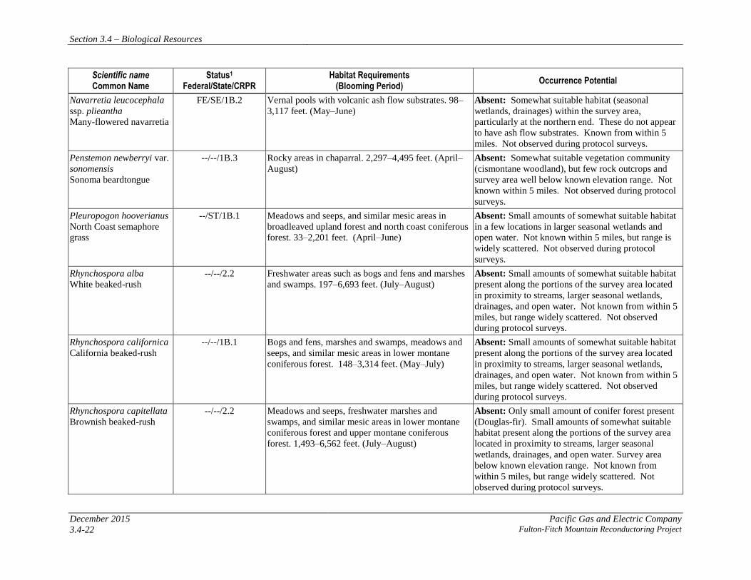
Navarretia leucocephala
ssp. plieantha
Many-flowered navarretia
FE/SE/1B.2 Vernal pools with volcanic ash flow substrates. 98–
3,117 feet. (May–June)
Absent: Somewhat suitable habitat (seasonal
wetlands, drainages) within the survey area,
particularly at the northern end. These do not appear
to have ash flow substrates. Known from within 5
miles. Not observed during protocol surveys.
Penstemon newberryi var.
sonomensis
Sonoma beardtongue
--/--/1B.3 Rocky areas in chaparral. 2,297–4,495 feet. (April–
August)
Absent: Somewhat suitable vegetation community
(cismontane woodland), but few rock outcrops and
survey area well below known elevation range. Not
known within 5 miles. Not observed during protocol
surveys.
Pleuropogon hooverianus
North Coast semaphore
grass
--/ST/1B.1 Meadows and seeps, and similar mesic areas in
broadleaved upland forest and north coast coniferous
forest. 33–2,201 feet. (April–June)
Absent: Small amounts of somewhat suitable habitat
in a few locations in larger seasonal wetlands and
open water. Not known within 5 miles, but range is
widely scattered. Not observed during protocol
surveys.
Rhynchospora alba
White beaked-rush
--/--/2.2 Freshwater areas such as bogs and fens and marshes
and swamps. 197–6,693 feet. (July–August)
Absent: Small amounts of somewhat suitable habitat
present along the portions of the survey area located
in proximity to streams, larger seasonal wetlands,
drainages, and open water. Not known from within 5
miles, but range widely scattered. Not observed
during protocol surveys.
Rhynchospora californica
California beaked-rush
--/--/1B.1 Bogs and fens, marshes and swamps, meadows and
seeps, and similar mesic areas in lower montane
coniferous forest. 148–3,314 feet. (May–July)
Absent: Small amounts of somewhat suitable habitat
present along the portions of the survey area located
in proximity to streams, larger seasonal wetlands,
drainages, and open water. Not known from within 5
miles, but range widely scattered. Not observed
during protocol surveys.
Rhynchospora capitellata
Brownish beaked-rush
--/--/2.2 Meadows and seeps, freshwater marshes and
swamps, and similar mesic areas in lower montane
coniferous forest and upper montane coniferous
forest. 1,493–6,562 feet. (July–August)
Absent: Only small amount of conifer forest present
(Douglas-fir). Small amounts of somewhat suitable
habitat present along the portions of the survey area
located in proximity to streams, larger seasonal
wetlands, drainages, and open water. Survey area
below known elevation range. Not known from
within 5 miles, but range widely scattered. Not
observed during protocol surveys.

Section 3.4 – Biological Resources
Pacific Gas and Electric Company December 2015 Fulton-Fitch Mountain Reconductoring Project 3.4-23
Scientific name Common Name
Status1 Federal/State/CRPR
Habitat Requirements (Blooming Period)
Occurrence Potential
Rhynchospora globularis
var. globularis
Round-headed beaked-
rush
--/--/2.1 Freshwater marshes and swamps. 148–197 feet.
(July–August)
Absent: Small amounts of somewhat suitable habitat
present along the portions of the survey area located
in proximity to streams, larger seasonal wetlands,
drainages, and open water. Has very limited known
range. Not known from within 5 miles. Not observed
during protocol surveys.
Sidalcea oregana ssp.
hydrophila
Marsh checkerbloom
--/--/1B.2 Freshwater marshes and swamps, and mesic areas in
riparian forest. 3,609–7,546 feet. (July–August)
Absent: Survey area is well below known elevation
range of taxon. Not known from within 5 miles. Not
observed during protocol surveys.
Sidalcea oregana ssp.
valida
Kenwood Marsh
checkerbloom
FE/SE/1B.1 Freshwater marshes and swamps. 377–492 feet.
(June–September)
Absent: Small amounts of somewhat suitable habitat
present along the portions of the survey area located
in proximity to streams, larger seasonal wetlands,
drainages, and open water. Has very limited known
range. Not known from within 5 miles. Not observed
during protocol surveys.
Streptanthus brachiatus
ssp. hoffmanii
Freed’s jewel-flower
--/--/1B.2 Serpentine soils/rock in chaparral and cismontane
woodland. 1,608–4,003 feet. (May–July)
Absent: No serpentine soils present. Survey area
somewhat below known elevation range. Not known
from within 5 miles. Not observed during protocol
surveys.
Streptanthus breweri var.
hesperidis (= S.
hesperidis)
Green jewel-flower
--/--/1B.2 Serpentine soils/rock in chaparral and cismontane
woodland. 426–2,493 feet. (May–July)
Absent: No serpentine soils present. Not known from
within 5 miles. Not observed during protocol surveys.
Stuckenia filiformis
Slender-leaved pondweed
--/--/2.2 Assorted shallow freshwater habitats such as marshes
and swamps. 984–7,054 feet. (May–July)
Absent: Small amounts of somewhat suitable habitat
present along the portions of the survey area located
in proximity to streams and open water. Survey area
below known range. Not known from within 5 miles,
but widely scattered range. Not observed during
protocol surveys.
Trifolium amoenum
Showy rancheria
clover/two-forked clover
FE/--/1B.1 Valley and foothill grassland, coastal bluff scrub.
Sometimes on serpentinite. 16–1,361 feet. (April–
June)
Absent: Somewhat suitable habitat present in
grassland, but no preferred serpentine habitat present.
Very limited range. Many occurrences believed to be
extirpated. Not known within 5 miles. Not observed
during protocol surveys.

Section 3.4 – Biological Resources
December 2015 Pacific Gas and Electric Company
3.4-24 Fulton-Fitch Mountain Reconductoring Project
Scientific name Common Name
Status1 Federal/State/CRPR
Habitat Requirements (Blooming Period)
Occurrence Potential
Trifolium hydrophilum
Saline clover
--/--/1B.2 Marshes and swamps, vernal pools, and similar mesic
areas in valley and foothill grassland. Alkaline areas.
0–984 feet. (April–June)
Absent: No alkaline wetlands present. Not known
within 5 miles. Not observed during protocol surveys.
Triquetrella californica
Coastal triquetrella
--/--/1B.2 Soil in coastal bluff scrub and coastal scrub. 33–328
feet.
Absent: No suitable coastal habitat present. Not
known within 5 miles. Not observed during protocol
surveys.
Viburnum ellipticum
Oval-leaved viburnum
--/--/2.3 Chaparral, cismontane woodland, and lower montane
coniferous forest. 705–4,593 feet. (May–June)
Absent: Suitable habitat is present along most of the
project corridor, although survey area at low end of
known range. Known from within 5 miles. Not
observed during protocol surveys. 1Status
Federal
FE Listed as Endangered under the federal Endangered Species Act
FT Listed as Threatened under the federal Endangered Species Act
State of California
SE California Fish and Game Code Endangered Species
ST California Fish and Game Code Threatened Species
SR California Fish and Game Code Rare Species
California Rare Plant Rank (CRPR)
1A Plant assumed extinct in California
1B Plants rare, threatened, or endangered in California and elsewhere
2 Plants rare, threatened, or endangered in California, but more common
elsewhere
Threat Ranks
0.1-Seriously threatened in California (over 80% of occurrences threatened
/ high degree and immediacy of threat)
0.2-Fairly threatened in California (20-80% occurrences threatened /
moderate degree and immediacy of threat)
0.3-Not very threatened in California (<20% of occurrences threatened/
low degree and immediacy of threat or no current threats known)
Section 3.4 – Biological Resources
Pacific Gas and Electric Company December 2015 Fulton-Fitch Mountain Reconductoring Project 3.4-25
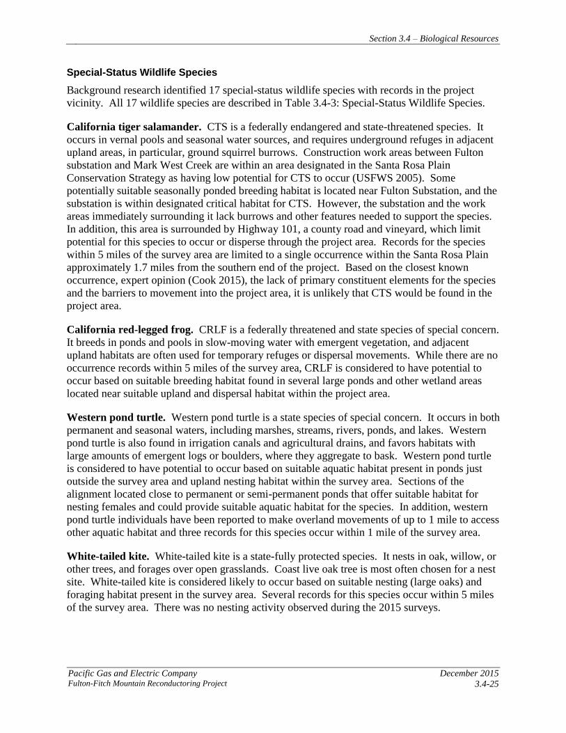
Special-Status Wildlife Species
Background research identified 17 special-status wildlife species with records in the project
vicinity. All 17 wildlife species are described in Table 3.4-3: Special-Status Wildlife Species.
California tiger salamander. CTS is a federally endangered and state-threatened species. It
occurs in vernal pools and seasonal water sources, and requires underground refuges in adjacent
upland areas, in particular, ground squirrel burrows. Construction work areas between Fulton
substation and Mark West Creek are within an area designated in the Santa Rosa Plain
Conservation Strategy as having low potential for CTS to occur (USFWS 2005). Some
potentially suitable seasonally ponded breeding habitat is located near Fulton Substation, and the
substation is within designated critical habitat for CTS. However, the substation and the work
areas immediately surrounding it lack burrows and other features needed to support the species.
In addition, this area is surrounded by Highway 101, a county road and vineyard, which limit
potential for this species to occur or disperse through the project area. Records for the species
within 5 miles of the survey area are limited to a single occurrence within the Santa Rosa Plain
approximately 1.7 miles from the southern end of the project. Based on the closest known
occurrence, expert opinion (Cook 2015), the lack of primary constituent elements for the species
and the barriers to movement into the project area, it is unlikely that CTS would be found in the
project area.
California red-legged frog. CRLF is a federally threatened and state species of special concern.
It breeds in ponds and pools in slow-moving water with emergent vegetation, and adjacent
upland habitats are often used for temporary refuges or dispersal movements. While there are no
occurrence records within 5 miles of the survey area, CRLF is considered to have potential to
occur based on suitable breeding habitat found in several large ponds and other wetland areas
located near suitable upland and dispersal habitat within the project area.
Western pond turtle. Western pond turtle is a state species of special concern. It occurs in both
permanent and seasonal waters, including marshes, streams, rivers, ponds, and lakes. Western
pond turtle is also found in irrigation canals and agricultural drains, and favors habitats with
large amounts of emergent logs or boulders, where they aggregate to bask. Western pond turtle
is considered to have potential to occur based on suitable aquatic habitat present in ponds just
outside the survey area and upland nesting habitat within the survey area. Sections of the
alignment located close to permanent or semi-permanent ponds that offer suitable habitat for
nesting females and could provide suitable aquatic habitat for the species. In addition, western
pond turtle individuals have been reported to make overland movements of up to 1 mile to access
other aquatic habitat and three records for this species occur within 1 mile of the survey area.
White-tailed kite. White-tailed kite is a state-fully protected species. It nests in oak, willow, or
other trees, and forages over open grasslands. Coast live oak tree is most often chosen for a nest
site. White-tailed kite is considered likely to occur based on suitable nesting (large oaks) and
foraging habitat present in the survey area. Several records for this species occur within 5 miles
of the survey area. There was no nesting activity observed during the 2015 surveys.

Section 3.4 – Biological Resources
December 2015 Pacific Gas and Electric Company
3.4-26 Fulton-Fitch Mountain Reconductoring Project
Table 3.4-3: Special-Status Wildlife Species
Scientific name Common Name
Status1 Federal/State
Habitat Requirements Occurrence Potential
Invertebrates
Syncaris pacifica
California
freshwater shrimp
FE / SE Endemic to Marin, Napa, and Sonoma counties. Found in low
elevations, low gradient streams where riparian cover is moderate
to heavy. Shallow pools away from main streamflow.
Unlikely to occur: Suitable habitat is
absent from the project area. Although low
gradient, low elevation streams occur at
Mark West, Pool, Wright, and Windsor
creeks, no project activities will occur in
these areas. Nearest CNDDB record is 5.5
miles east of project area.
Fish
Lavinia
symmetricus
navarroensis
Navarro roach
--/ SSC Habitat generalists. Found in warm intermittent streams as well as
cold, well-aerated streams.
Unlikely to occur: Suitable habitat is
absent from the project area. Occurrence
records within 5 miles of the survey area.
However, no habitat is present in the survey
area.
Hysterocarpus
traski pomo
Russian River tule
perch
-- / SSC Low elevation streams of the Russian River system. Requires
clear, flowing water with abundant cover. They also require deep
(> 1 meter) pool habitat.
Unlikely to occur: Suitable habitat is
absent from the project area. No work
activities are proposed for watercourses
having potential to support the species.
Mylopharodon
conocephalus
Hardhead
-- / SSC Low to mid-elevation streams in the Sacramento–San Joaquin
drainage. Also present in the Russian River. Clear, deep pools
with sand-gravel-boulder bottoms and slow water velocity.
Unlikely to occur: Suitable habitat is
absent from the project area. Furthermore,
all waterway crossings in the survey area
lack suitable habitat for this species.
Oncorhynchus
kisutch
Coho salmon -
central California
coast ESU
FE / SE Require beds of loose, silt-free, coarse gravel for spawning. Also
need cover, cool water, and sufficient dissolved oxygen.
Unlikely to occur: Suitable habitat is
absent from the project area. Furthermore,
suitable watercourses are not present in the
survey area.
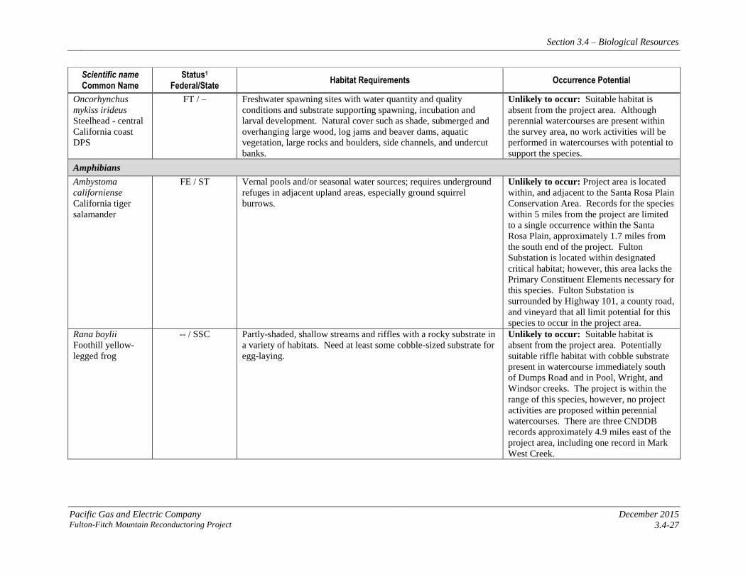
Section 3.4 – Biological Resources
Pacific Gas and Electric Company December 2015 Fulton-Fitch Mountain Reconductoring Project 3.4-27
Scientific name Common Name
Status1 Federal/State
Habitat Requirements Occurrence Potential
Oncorhynchus
mykiss irideus
Steelhead - central
California coast
DPS
FT / – Freshwater spawning sites with water quantity and quality
conditions and substrate supporting spawning, incubation and
larval development. Natural cover such as shade, submerged and
overhanging large wood, log jams and beaver dams, aquatic
vegetation, large rocks and boulders, side channels, and undercut
banks.
Unlikely to occur: Suitable habitat is
absent from the project area. Although
perennial watercourses are present within
the survey area, no work activities will be
performed in watercourses with potential to
support the species.
Amphibians
Ambystoma
californiense
California tiger
salamander
FE / ST Vernal pools and/or seasonal water sources; requires underground
refuges in adjacent upland areas, especially ground squirrel
burrows.
Unlikely to occur: Project area is located
within, and adjacent to the Santa Rosa Plain
Conservation Area. Records for the species
within 5 miles from the project are limited
to a single occurrence within the Santa
Rosa Plain, approximately 1.7 miles from
the south end of the project. Fulton
Substation is located within designated
critical habitat; however, this area lacks the
Primary Constituent Elements necessary for
this species. Fulton Substation is
surrounded by Highway 101, a county road,
and vineyard that all limit potential for this
species to occur in the project area.
Rana boylii
Foothill yellow-
legged frog
-- / SSC Partly-shaded, shallow streams and riffles with a rocky substrate in
a variety of habitats. Need at least some cobble-sized substrate for
egg-laying.
Unlikely to occur: Suitable habitat is
absent from the project area. Potentially
suitable riffle habitat with cobble substrate
present in watercourse immediately south
of Dumps Road and in Pool, Wright, and
Windsor creeks. The project is within the
range of this species, however, no project
activities are proposed within perennial
watercourses. There are three CNDDB
records approximately 4.9 miles east of the
project area, including one record in Mark
West Creek.

Section 3.4 – Biological Resources
December 2015 Pacific Gas and Electric Company
3.4-28 Fulton-Fitch Mountain Reconductoring Project
Scientific name Common Name
Status1 Federal/State
Habitat Requirements Occurrence Potential
Rana draytonii
California red-
legged frog
FT / SSC Breeds in ponds and pools in slow-moving streams with emergent
vegetation; adjacent upland habitats are often used for temporary
refuges or dispersal movements.
Potential to occur: No occurrence records
within 5 miles of the project area.
However, potentially suitable breeding
habitat was found in ponds located in
grassland habitat in the survey area.
Suitable upland habitat also present in the
grassland habitat.
Reptiles
Emys marmorata
Western pond
turtle
– / SSC Occurs in both permanent and seasonal waters, including marshes,
streams, rivers, ponds, and lakes. Also found in irrigation canals
and agricultural drains. They favor habitats with large amounts of
emergent logs or boulders, where they aggregate to bask.
Potential to occur: CNDDB occurrences
within 5 miles of the project. Suitable
aquatic habitat is present in ponds just
outside the project area, and potential
upland nesting habitat lies within the
project area.
Birds
Athene cunicularia
hypugaea
Western burrowing
owl
– / SSC Nests in burrows (often constructed by ground squirrels) and
forages in low-growing grasslands and other open, semi-arid
habitats.
Unlikely to occur: No CNDDB
occurrences within 5 miles of the project
area. Some marginal habitat is present in
the grassland habitat in the northern portion
of the project area; however, this habitat
lacks significant small mammal activity and
few burrows were observed during surveys.
Elanus leucurus
White-tailed kite
– / FP Nests in oak, willow or other trees and forages over open
grasslands. A coast live oak tree is often chosen as a nest site.
Likely to occur: CNDDB occurrences
within 5 miles of the project area. Suitable
nesting (large oaks) and foraging habitat
present in the vicinity of the project area.
Mammals
Antrozous pallidus
Pallid bat
– / SSC Open, dry habitats such as grasslands, shrublands, and woodlands
with rocky areas for roosting. Roosts in anthropogenic structures
(buildings and bridges), cliff crevices of rock faces, and hollow
trees.
Potential to occur: CNDDB occurrences
within 5 miles of the project area. Suitable
day roosting habitat present in trees in the
project area. Surveys for bats concluded
that there is low potential for roosting bats.
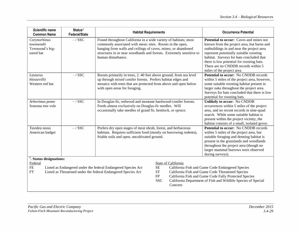
Section 3.4 – Biological Resources
Pacific Gas and Electric Company December 2015 Fulton-Fitch Mountain Reconductoring Project 3.4-29
Scientific name Common Name
Status1 Federal/State
Habitat Requirements Occurrence Potential
Corynorhinus
townsendii
Townsend’s big-
eared bat
– / SSC Found throughout California in a wide variety of habitats; most
commonly associated with mesic sites. Roosts in the open,
hanging from walls and ceilings of caves, mines, or abandoned
structures in or near woodlands and forests. Extremely sensitive to
human disturbance.
Potential to occur: Caves and mines not
known from the project area, but barns and
outbuildings in and near the project area
represent potentially suitable roosting
habitat. Surveys for bats concluded that
there is low potential for roosting bats.
There are no CNDDB records within 5
miles of the project area.
Lasiurus
blossevillii
Western red bat
– / SSC Roosts primarily in trees, 2–40 feet above ground, from sea level
up through mixed conifer forests. Prefers habitat edges and
mosaics with trees that are protected from above and open below
with open areas for foraging.
Potential to occur: No CNDDB records
within 5 miles of the project area, however,
some suitable roosting habitat present in
larger oaks throughout the project area.
Surveys for bats concluded that there is low
potential for roosting bats.
Arborimus pomo
Sonoma tree vole
– / SSC In Douglas-fir, redwood and montane hardwood-conifer forests.
Feeds almost exclusively on Douglas-fir needles. Will
occasionally take needles of grand fir, hemlock, or spruce.
Unlikely to occur: No CNDDB
occurrences within 5 miles of the project
area, and no recent records in nine-quad
search. While some suitable habitat is
present within the project vicinity, the
habitat consists of a small, isolated grove.
Taxidea taxus
American badger
– / SSC Prefers dry open stages of most shrub, forest, and herbaceous
habitats. Requires sufficient food (mostly on burrowing rodents),
friable soils and open, uncultivated ground.
Potential to occur: No CNDDB records
within 5 miles of the project area, but
suitable foraging and denning habitat is
present in the grasslands and woodlands
throughout the project area (though no
larger mammal burrows were observed
during surveys). 1. Status designations:
Federal
FE Listed as Endangered under the federal Endangered Species Act
FT Listed as Threatened under the federal Endangered Species Act
State of California
SE California Fish and Game Code Endangered Species
ST California Fish and Game Code Threatened Species
FP California Fish and Game Code Fully Protected Species
SSC California Department of Fish and Wildlife Species of Special
Concern
Section 3.4 – Biological Resources
December 2015 Pacific Gas and Electric Company
3.4-30 Fulton-Fitch Mountain Reconductoring Project
Pallid bat. Pallid bat is a state species of special concern. It occurs in open, dry habitats such as
grasslands, shrublands, and woodlands, with rocky areas for roosting. It is found to roost in
anthropogenic structures (buildings and bridges), cliff crevices of rock faces, and hollow trees.
Pallid bat is considered to have potential to occur based on suitable day roosting habitat present
in trees in the survey area; however, bats surveys completed in July 2015 determined low
potential overall. As a result of its basic design structure and a lack of observed bat roosting
signs, a large barn adjacent to a project pull site/staging area was determined unlikely to support
roosting bats.
Townsend’s big-eared bat. Townsend’s big-eared bat is a state species of special concern. It
occurs throughout California in a wide variety of habitats, and is most commonly associated with
mesic sites. It is found to roost in the open, hanging from walls and ceilings of caves, and in
mines or abandoned structures in or near woodlands and forests. This species is extremely
sensitive to human disturbance. While there are no occurrence records within 5 miles of the
survey area, Townsend’s big-eared bat is considered to have potential to occur based on the
presence of barns and outbuildings in and near the survey area that represent potentially suitable
roosting habitat. However, bats surveys completed in July 2015 determined low potential overall
and no potential in the barn near the project pull site/staging area. This determination was based
on the lack of any bat sign in the barn and the trees that were inspected as well as failure to
observed any bats during emergence surveys at potential roost sites.
Western red bat. Western red bat is a state species of special concern. It roosts primarily in
trees, 2 to 40 feet above ground, at elevations ranging from sea level through mixed conifer
forests. It prefers habitat edges and mosaics with trees that are protected from above and open
below, with open areas for foraging. While there are no occurrence records within 5 miles of the
survey area, Western red bat is considered to have the potential to occur based on the presence of
suitable roosting habitat in larger oaks throughout the survey area. However, bats surveys
completed in July 2015 determined low potential overall.
American badger. American badger is a state species of special concern. It prefers dry, open
spaces of most shrub, forest, and herbaceous habitats. It requires sufficient food (mostly feeding
on burrowing rodents), friable soils, and open, uncultivated ground. While there are no
occurrence records within 5 miles of the survey area, American badger is considered to have
potential to occur based on suitable foraging and denning habitat in the grasslands and
woodlands throughout the survey area.
Habitat Conservation Plans
No HCPs apply to the project area. However, a portion of the project area is within the Santa
Rosa Plain Conservation Strategy Survey Area, as discussed previously in Section 3.4.2.1,
Regulatory Background.
3.4.4 APPLICANT-PROPOSED MEASURES AND POTENTIAL IMPACTS
The following sections describe significance criteria for impacts related to biological resources
derived from Appendix G of the CEQA Guidelines, provide APMs to reduce impacts, and assess
potential project-related construction and operational impacts on biological resources.

Section 3.4 – Biological Resources
Pacific Gas and Electric Company December 2015 Fulton-Fitch Mountain Reconductoring Project 3.4-31
3.4.4.1 Significance Criteria
According to Section 15002(g) of the CEQA Guidelines, “a significant effect on the environment
is defined as a substantial adverse change in the physical conditions which exist in the area
affected by the proposed project.” As stated in Section 15064(b) of the CEQA Guidelines, the
significance of an activity may vary with the setting. Per Appendix G of the CEQA Guidelines,
the potential significance of project-related impacts on biological resources were evaluated for
each of the criteria listed in Table 3.4-1, as discussed in Section 3.4.4.3.
3.4.4.2 Applicant-Proposed Measures
PG&E will implement the following APMs:
APM BIO-1: General Avoidance of Biological Resources Impacts
This APM consists of the following components:
• Environmental awareness training. PG&E will conduct environmental awareness
training for all construction and on-site personnel prior to the beginning of site work.
Training will include a discussion of the avoidance and minimization measures that are
being implemented to protect biological resources, as well as the terms and conditions of
any Biological Opinion or other permit conditions that apply to the project. Training will
include information on the federal and state Endangered Species Acts and the
consequences of noncompliance with these acts. Under this program, workers shall be
informed about the presence, life history, and habitat requirements of all listed and
special-status species with a potential to be affected within the project area. Training will
also include information on state and federal laws protecting nesting birds, wetlands, and
other water resources, as applicable and appropriate to the project.
• Biological monitoring to avoid impacts near or in potentially sensitive habitat. A
qualified biological monitor will be on site during ground-disturbing construction
activities near and within sensitive habitat or resources, and will monitor implementation
and compliance with APMs relating to the sensitive habitat. The monitor will have the
authority to stop work or implement alternative work practices, as determined by
PG&E’s biologist in consultation with agencies and construction personnel, as
appropriate, if construction activities are likely to impact sensitive biological resources.
• Marking of sensitive habitat or resource areas. Sensitive habitat or resources—such
as active bird nests, burrows that area near suitable aquatic habitat that might support
CTS or CRLF, and seasonal wetlands—identified during pre-construction surveys to be
within or adjacent to project work areas will be marked or otherwise delineated to
minimize impacts to these resources.
• Work in California red-legged frog habitat. Construction activities in suitable CRLF
habitat will be restricted to the dry season (April 15 through October 15) to the extent
feasible. If construction activities must occur within suitable habitat during the wet
season, when CRLF may be migrating overland and breeding in the vicinity, a qualified
biologist will determine if it is appropriate to fence the perimeter of pull sites, staging
Section 3.4 – Biological Resources
December 2015 Pacific Gas and Electric Company
3.4-32 Fulton-Fitch Mountain Reconductoring Project
areas, and/or landing zones. Fencing will be effective amphibian exclusion fencing.
Installation of exclusion fencing will occur under the supervision of a qualified biologist.
The amphibian exclusion fencing will remain in place for the duration of construction
during the wet season, and will be monitored regularly by environmental inspectors or
biologists. Where access is necessary, gates will be installed with the exclusion fence.
These measures may be refined slightly to be consistent with measures established during
the Section 7 consultation process with USFWS.
• Work in California tiger salamander habitat. The project area has very limited
potential habitat for CTS in the area surrounding Fulton Substation, and impacts to the
species are unlikely. If construction activities must occur during the wet season, a
qualified biologist will determine if it is appropriate to fence the perimeter of work areas
around Fulton Substation. Fencing will be effective amphibian exclusion fencing.
Installation of exclusion fencing will occur under the supervision of a qualified biologist.
The amphibian exclusion fencing will remain in place for the duration of construction
during the wet season, and will be monitored regularly by environmental inspectors or
biologists. Where access is necessary, gates will be installed with the exclusion fence.
• Litter and trash management. All food scraps, wrappers, food containers, cans, bottles,
and other trash from the project area will be deposited in closed trash containers and
removed from the project site daily.
• Parking. Vehicles and equipment will be parked on pavement, existing roads, and
previously disturbed or developed areas or work areas. Off-road parking will only be
permitted in previously identified and designated work areas.
• Route and work area limitations. Vehicles will be confined to established roadways
and pre-approved access roads, overland routes, and access areas. Access routes and
construction work areas will be limited to the minimum necessary to achieve the project
goals.
• Maintenance and refueling. All equipment will be maintained to minimize the potential
for leaks of automotive fluids such as fuels, solvents, or oils. All refueling and
maintenance of vehicles and other construction equipment will be restricted to designated
staging areas located at least 100 feet from any down-gradient aquatic habitat, unless
otherwise isolated from habitat by secondary containment. Proper spill prevention and
cleanup equipment will be maintained in all refueling areas.
• Pets and firearms. No pets or firearms will be permitted at the project site.
• Cover excavations. All excavations in excess of 2 feet deep will be sloped, have escape
ramps installed that are suitable for the escape of wildlife, or be thoroughly covered at the
end of the day. All trenches and excavations will be inspected for wildlife at the
beginning of the workday and prior to backfilling. If a special-status species is
discovered in a trench or excavation area, work in the area will be redirected, and the
special-status species will be allowed to leave the trench and the area of its own accord.

Section 3.4 – Biological Resources
Pacific Gas and Electric Company December 2015 Fulton-Fitch Mountain Reconductoring Project 3.4-33
In the event that any special-status species is trapped in a trench or an excavation and is
unable to leave on its own accord, removal will be performed or overseen by a biological
monitor with the applicable permits for handling of the species.
• Restore temporarily disturbed habitats. All areas that are temporarily disturbed as a
result of project activities will be restored upon completion of construction. Disturbed
areas will be restored to pre-project conditions or as otherwise requested by the
landowner.
• Work during the wet season. During wet weather or the rainy season, all open holes,
pits, and trenches will be protected to ensure that frogs and salamanders do not become
entrapped. Qualified personnel will install protective fencing, coverings, or ramps to
either prevent wildlife from falling into excavations or to allow for escape. At the end of
each work day, trenches will be covered and/or fenced. Excavations sites will be
inspected each morning, prior to the start of construction activities, to ensure that no
wildlife are trapped.
During the wet season or after a rain event (with greater than 0.1 inch of rainfall), all
construction personnel will check underneath vehicles (i.e., tires, tracks, etc.) for the
presence of frogs and/or salamanders. Any discovered wildlife will be reported to the on-
site biologist or to PG&E environmental staff for relocation assistance.
Use Best Management Practices and implement Stormwater Pollution Prevention Plan
(SWPPP) measures to minimize erosion and prevent sediment from leaving work areas
and entering any aquatic habitat. Do not use monofilament netting with any erosion-
control materials.
APM BIO-2: Avoid Impacts on Nesting Birds
If work is scheduled during the nesting season (February 1 through August 31), nest
detection surveys will correspond with a standard buffer for individual species in accordance
with the species-specific buffers set forth in Appendix E of the PEA and will occur within 15
days prior to the start of work activities at designated construction areas, staging areas, and
landing zones to determine nesting status by a qualified biologist. Nest surveys will be
accomplished by ground surveys and/or by helicopter and will support phased construction,
with surveys scheduled to be repeated if construction lapses in a work area for 15 days
between March and July. Access for ground surveys will be subject to property access
permission. Helicopter flight restrictions for nest detection surveys may be in effect for
densely populated residential areas, and will include observance of appropriate established
buffers and avoidance of hovering in the vicinity of active nest sites.
If active nests containing eggs or young are found, the biologist will establish a species-
specific nest buffer, as defined in Appendix E of the PEA. Where feasible, standard buffers
will apply, although the biologist may increase or decrease the standard buffers in accordance
with the factors set forth in Appendix E. Nesting pair acclimation to disturbance in areas with
regularly occurring human activities will be considered when establishing nest buffers. The
established buffers will remain in effect until the young have fledged or the nest is no longer
Section 3.4 – Biological Resources
December 2015 Pacific Gas and Electric Company
3.4-34 Fulton-Fitch Mountain Reconductoring Project
active as confirmed by the biologist. Active nests will be periodically monitored until the
biologist has determined that the young have fledged or once construction ends. Per the
discretion of the biologist, vegetation removal by hand may be allowed within nest buffers or
in areas of potential nesting activity. Inactive nests may be removed in accordance with
PG&E’s approved avian permits. The biologist will have authority to order the cessation of
nearby project activities if nesting pairs exhibit signs of disturbance.
All references in this APM to biologists refer to qualified biologists with a bachelor’s degree
or above in a biological science field and demonstrated field expertise in ornithology, in
particular, nesting behavior.
APM BIO-3: Wetland and Water Feature Protection Measures
The following measures will be implemented to avoid and minimize project impacts on
wetland and water features:
• To the maximum extent feasible, design the project to avoid wetland and water features.
Where impacts on the features cannot be avoided, coordination may be required with the
USACE and RWQCB.
• Where avoidance is feasible, delineate wetland and water features and establish exclusion
zones along the upland margins to restrict entrance by construction personnel and
equipment.
• Conduct all fueling of vehicles, equipment, and helicopters per APM BIO-1,
Maintenance and Refueling.
• To the extent feasible, complete any necessary construction activities within or adjacent
to wetland or water features during the dry season (October 15 to April 15). For
construction activities occurring outside of the dry season, appropriate erosion-control
and stormwater protection measures will be implemented as identified in the project
SWPPP, if necessary.
APM BIO-4: Conduct Pre-Construction Surveys for Special-Status Plants
No special-status plants were observed during protocol surveys conducted in 2011 and 2012.
Resurvey these areas during the appropriate blooming period prior to construction to confirm
that conditions have not changed.
APM BIO-5: Conduct Pre-Construction Surveys for Special-Status Bats
If reconductoring occurs between April and September (i.e., bat reproductive season)
accessible trees that are 10-inches dbh or greater and rural outbuildings located within 100
feet of pull sites and landing zones that could provide potential bat habitat will be assessed by
desktop review and field surveys. Potential bat habitat includes woodpecker holes,
exfoliating bark, and branch and bole hollows. If desktop review and field surveys determine
that trees and/or outbuildings have low to no potential for roosting habitat, no further action
is required. If desktop review or field surveys determine that trees and/or outbuildings have
Section 3.4 – Biological Resources
Pacific Gas and Electric Company December 2015 Fulton-Fitch Mountain Reconductoring Project 3.4-35
moderate to high potential for roosting habitat, the following procedure will be employed
during tree trimming and removal:
• A qualified biologist will be present for trimming or removal of trees 10 inches or greater
dbh.
• To the extent feasible, trees/snags/stumps will be cut down on warm days in late morning
to afternoon when any bats present are likely to be warm and able to fly.
• The qualified biologist will inspect crevices and cavities to the extent possible. If bats
may be in a tree bole or branch cavity, the qualified biologist will attempt to expose them
and allow escape. For example, if the cavity cannot be investigated by the qualified
biologist, then carefully cut successive sections above the cavity to open it, waiting up to
10 minutes in between each cut, and determine if it is empty or allow any bats inside to
crawl or fly out.
• Create noise and vibration disturbance on the tree (e.g., concussive hitting with
equipment and/or chainsaw cutting) for at least 15 minutes before carefully opening up
potential crevices and cavities for inspection and clearance.
• Remove and set aside any branches that may contain bats. For example, cut the branches
off intact and set them upright against trees away from the work activity area to allow any
bats present to passively escape.
APM BIO-6: Conduct Pre-Construction Surveys for California Red-Legged Frog
A qualified biologist shall conduct a pre-construction survey of the work areas within
suitable habitat for CRLF for CRLF within 24 hours prior to the start of work. Any areas
where frogs are observed will be flagged for avoidance, and clear instructions will be given
to all crew members during tailboards of areas to avoid where CRLF may be present.
APM BIO-7: Conduct Pre-Construction Surveys for California Tiger Salamander
A qualified biologist shall conduct a pre-construction survey of the work areas with potential
CTS habitat within 24 hours prior to potential ground disturbance, specifically in the vicinity
of Fulton Substation. Burrows will be marked and avoided during construction activities to
the extent feasible. The initial ground-disturbing work at this location will be restricted to
the dry season.
APM BIO-8: Conduct Pre-Construction Survey for American Badger
A survey for active dens of American badgers shall be performed by a qualified biologist
within 30 days prior to construction grading or land clearing. Surveys shall be conducted
within suitable habitat. The width of the pre-activity survey will be 250 feet on either side of
the construction area or to the extent of PG&E’s right-of-way. Construction may proceed
once it is determined that there are no active dens in the survey area. If active dens are
present, the dens shall be avoided during the breeding season, and a 50-foot buffer around the
Section 3.4 – Biological Resources
December 2015 Pacific Gas and Electric Company
3.4-36 Fulton-Fitch Mountain Reconductoring Project
den sites shall be established. Smaller buffers may be established through consultation with
CDFW.
APM BIO-9: Conduct Pre-Construction Survey for Western Pond Turtle
A survey for western pond turtle shall be performed by a qualified biologist within 24 hours
prior to work within riparian habitats. Individual western pond turtles, if found in the work
area during spring/nesting season, shall be relocated out of harm’s way and outside of the
construction area in the direction of travel. Similarly, if found during hibernation movements
in winter, individual western pond turtles will be relocated outside of the construction area in
the direction of travel.
APM BIO-10: Tree Removal and Mitigation
Tree removal will be minimized to what is required to implement the project. For removal of
large valley oak trees greater than 20 inches dbh or small valley oaks with a cumulative dbh
greater than 60 inches that occurs within the Sonoma County Valley Oak Combining District,
PG&E will coordinate with landowners to either replace or pay an in-lieu fee to the County
valley oak planting program. Any protected trees that are otherwise removed will be
documented and replaced at a 1:1 ratio or other measure derived through coordination with
Sonoma County or the Town of Windsor that provides an equal level of compensation.
3.4.4.3 Potential Impacts
Potential project impacts on biological resources were evaluated against the CEQA significance
criteria and are discussed below. The impact analysis evaluates potential project impacts during
the construction phase and operation and maintenance (O&M) phase.
The project includes reconductoring and pole replacement and removal, as well as minor
substation modifications. The O&M activities required for the reconductored power and
transmission lines and substation modifications will not increase from those currently required
for the existing system; thus, no operation-related impacts on biological resources will occur.
All work at Fitch Mountain Substation will be completed within the existing fence line, where
the surface of the area was previously improved and covered with compacted fill. Therefore, the
impact analysis is focused only on construction activities that are required to install the new
conductor, replace and remove poles, and to establish required access and construction work
areas, as described in Chapter 2.0, Project Description.
a) Would the project have a substantial adverse effect, either directly or through habitat modifications, on any species identified as a candidate, sensitive, or special-status species in local or regional plans, policies, or regulations, or by the California Department of Fish and Wildlife or U.S. Fish and Wildlife Service? Less-than-Significant Impact
The project will not have any substantial adverse effects on special-status species. Although
several special-status plant species have the potential to occur in the project area, 2 years of
surveys were conducted and no occurrences were documented. Additional surveys will take
place in 2016, prior to project construction, to confirm that these plant species are absent from
the project area and will not be affected. Implementation of APM BIO-4 will further reduce the
potential for impacts on special-status plants.

Section 3.4 – Biological Resources
Pacific Gas and Electric Company December 2015 Fulton-Fitch Mountain Reconductoring Project 3.4-37
Several special-status wildlife species were identified as having the potential to occur within the
project area. The project will not have substantial adverse effects on any of these species.
Implementation of APM BIO-1, APM BIO-2, APM BIO-3, and APM BIO-5 will further reduce
the potential for impacts on special-status wildlife.
California Tiger Salamander
CTS has low potential to occur in the immediate vicinity of Fulton Substation. In the unlikely
event that CTS enters the project area, individual salamanders could be crushed or killed by
equipment. However, the work areas are ruderal habitat surrounded by vineyards, major roads,
and the substation and isolated from suitable ponds were breeding could occur. It is 1.7 miles
from the nearest occurrence and presence of individuals is not likely. Therefore, impacts on CTS
will be less than significant, and implementation of APM BIO-1, APM BIO-3, and APM BIO-7
will further reduce this less-than-significant impact.
California Red-Legged Frog
CRLF has moderate potential to occur in the project area in aquatic and upland habitats. No
wetlands that may be suitable habitat for CRLF will be impacted; however, approximately 30
acres of potential dispersal habitat may be temporarily impacted by the project. Initial ground-
disturbing work will be conducted during the dry season, when frogs are unlikely to disperse
through upland habitat. Direct impact on upland habitats that might harbor CRLF will be
avoided by conducting pre-construction surveys. If CRLF is observed in any work area, the area
will be avoided until the species has moved from the area on its own. Impacts on CRLF will be
less than significant with the implementation of APM BIO-1, APM BIO-3, and APM BIO-6.
Western Pond Turtle
Western pond turtle has the potential to occur in the project area. Although they are expected to
be restricted to aquatic habitats where no work will occur, some upland habitat may be used for
nesting and dispersal. To avoid impacting western pond turtles nesting or dispersing through
upland habitats, pre-construction surveys will be conducted. Therefore, impacts on western pond
turtle will be less than significant, and implementation of APM BIO-1, APM BIO-3, and APM
BIO-9 will further reduce these less-than-significant impacts.
White-Tailed Kite, Raptors, and Nesting Birds
White-tailed kite, raptors, and nesting birds have the potential to nest in or near the project area.
During nesting season, birds could be adversely affected if construction activities occur near
active nests. Direct impacts could include nest destruction or removal during vegetation removal
or trimming activities. Indirect impacts could include nest abandonment or premature fledging
from construction-related noise and vibration. Raptor and nesting bird surveys were conducted
during the 2015 nesting season to identify nesting locations to facilitate project planning.
Additional surveys will be conducted during the 2016 nesting season, as indicated in APM BIO-
2. Any nests identified during these surveys will be planned for avoidance, either seasonally (by
working outside the nesting season) or geographically (by avoiding work in that location). To
further reduce the potential for adverse impacts on nesting white-tailed kites, raptors, and other
birds, pre-construction nesting bird surveys will be conducted and no-work buffers will be
created. Impacts on white-tailed kite, raptors, and nesting birds will be less than significant, and

Section 3.4 – Biological Resources
December 2015 Pacific Gas and Electric Company
3.4-38 Fulton-Fitch Mountain Reconductoring Project
implementation of APM BIO-1 and APM BIO-2 will further reduce these less-than-significant
impacts.
Pallid Bat, Townsend’s Big-Eared Bat, Western Red Bat
Pallid bat, Townsend’s big-eared bat, and Western red bat each have the potential to occur in the
project area. These species could roost in structures near project construction areas or in trees
near work activities. Noise or vibration from heavy equipment or helicopters could disturb
roosting bats, resulting in reduced fitness and possible death. Vegetation trimming could
displace individual bats, if present. Noise or vibration from heavy equipment will be temporary
and short-term. Much of the noise of vibration work is expected to occur when bats are
seasonally absent from the area. Surveys conducted during July 2015 determined that low-
quality roosting habitat is located in the project area. Impacts on bats will be less than
significant, and implementation of APM BIO-1 and APM BIO-5 will further reduce these less-
than-significant impacts.
American Badger
American badger has the potential to occur in the project area. If present, project activities could
impact badger dens. To avoid potential impacts on American badger, pre-construction surveys
will be conducted to identify any badger dens, and any occupied dens will be avoided. Impacts
on America badger will be less than significant, and implementation of APM BIO-1 and APM
BIO-8 will further reduce these less-than-significant impacts.
b) Would the project have a substantial adverse effect on any riparian habitat or other sensitive natural community identified in local or regional plans, policies, regulations, or by the California Department of Fish and Wildlife or U.S. Fish and Wildlife Service? Less-than-Significant Impact
The project will have no substantial adverse effect on riparian or other sensitive natural habitats.
The project is designed to avoid wetland and riparian areas to the maximum extent feasible.
Some riparian vegetation is proposed for trimming or removal to establish access roads;
however, only the minimum amount necessary will be removed or trimmed. Conductor will
span several riparian areas; however, these areas will not require access and will not be impacted
by project activities.
The project includes work within an area designated as critical habitat for CTS. Although this
area is designated critical habitat, it lacks the primary constituent elements necessary to support
CTS. Therefore, the project will have a less-than-significant impact on critical habitat for CTS.
The project will be located within a portion of the Santa Rosa Plain Conservation Strategy Study
Area; however, none of the construction activities proposed will conflict with the guidelines of
the strategy and the impact will be less than significant.

Section 3.4 – Biological Resources
Pacific Gas and Electric Company December 2015 Fulton-Fitch Mountain Reconductoring Project 3.4-39
c) Would the project have a substantial adverse effect on federally protected wetlands as defined by Section 404 of the Clean Water Act (including, but not limited to, marsh, vernal pool, coastal, etc.) through direct removal, filling, hydrological interruption, or other means? Less-than-Significant Impact
The project may cause minor temporary impacts on seasonal wetlands that need to be crossed
with vehicles and equipment. The project may also replace an existing culvert in a waterway.
These protected wetlands will be restored to pre-project conditions upon completion of
construction, and the project will comply with the requirements of all agency permits.
Therefore, the project will have a less-than-significant impact on federally protected wetlands.
d) Would the project interfere substantially with the movement of any native resident or migratory fish or wildlife species or with established native resident or migratory wildlife corridors, or impede the use of native wildlife nursery sites? Less-than-Significant Impact
The project will have no substantial effect on wildlife movement corridors. Construction
activities at pole locations along the alignment will occur for a short duration (less than 1 week),
and will occupy relatively small areas for staging, construction, and access. Terrestrial animals
can freely move around these temporary work locations. No work will take place in any streams
or creeks that could support migratory fish. Therefore, the project will have a less-than-
significant impact on wildlife movement corridors.
e) Would the project conflict with any local policies or ordinances protecting biological resources, such as a tree preservation policy or ordinance? Less-than-Significant Impact
The project will not conflict with any local policies or ordinances protecting biological resources.
The project will occur within a portion of the Santa Rosa Plain Conservation Strategy Study
Area; however, none of the construction activities conflict with the guidelines of the strategy.
To avoid impacts on trees, construction work areas have been sited in open areas to the extent
possible in order to minimize the need for tree trimming or removal; however, tree trimming and
removal of oaks within project work areas, along access roads, and beneath the electric utility
lines may be necessary in some locations. Approximately 30 acres of vegetation trimming and
tree or shrub removal will be required to establish construction work areas, project access, and
provide clearance along the reconductored line. Although the project is regulated by the CPUC
and will not be subject to local land use regulations, such as the Town of Windsor or Sonoma
County’s discretionary permit for oak tree, heritage, or landmark tree removal, PG&E will
implement APM BIO-10, which is consistent with the Town of Windsor and Sonoma County’s
tree replacement standards to further reduce less-than-significant impacts.
f) Would the project conflict with the provisions of an adopted Habitat Conservation Plan, Natural Community Conservation Plan, or other approved local, regional, or state habitat conservation plan? Less-than-Significant Impact
The project will not conflict with any conservation plans. The project will occur within a portion
of the Santa Rosa Plain Conservation Strategy Study Area; however, none of the construction
activities conflict with guidelines of the strategy, and there will be no impact.
Section 3.4 – Biological Resources
December 2015 Pacific Gas and Electric Company
3.4-40 Fulton-Fitch Mountain Reconductoring Project
3.4.5 REFERENCES
Baldwin, B.G. et al. 1993. The Jepson Manual, Vascular Plants of California. Second Edition.
University of California Press, Berkeley.
Best, C., et al. 1996. A Flora of Sonoma County. California Native Plant Society. Sacramento,
California.
Burridge, Betty. 1995. Sonoma County Breeding Bird Atlas. Published by the Madrone
Audubon Society. Santa Rosa, California.
California Department of Fish and Game (CDFG). 2011. Rarefind: a California Natural
Diversity Database (CNDDB), commercial version. Wildlife and Habitat Data Analysis
Branch. Accessed in March 2011, Sacramento, California.
CNPS. 2011. Inventory of rare and endangered plants of California (online version, 8th edition).
Online: http://www.cnps.org/cnps/rareplants/inventory/. Accessed in March 2011.
_____. 2011 revision. CNPS Botanical Survey Guidelines. Online:
http://www.cnps.org/cnps/rareplants/pdf/cnps_survey_guidelines.pdf. Assessed in March
2011.
Cook, D. 2015. Personal communication between Dave Cook, Senior Environmental Specialist-
Sonoma County Water Agency, and Karla Marlow, GANDA Wildlife Biologist
regarding California red-legged frog and California tiger salamander.
NRCS. 2011. Web Soil Survey of survey area in Sonoma County. Online:
http://websoilsurvey.nrcs.usda.gov/app/HomePage.htm. Assessed in March 2011.
Sawyer, J.O., T. Keeler-Wolf, and J.M., Evens. 2009. A manual of California vegetation, 2nd
edition. California Native Plant Society, Sacramento, CA
University of California, Berkeley (U.C. Berkeley). 2011. Calphotos website. Online
http://www.calphotos.berkeley.edu. Accessed in March through June 2011.
U.S. Fish and Wildlife Service (USFWS). 2011. Sacramento Fish & Wildlife Office Species List.
Online: at http://www.fws.gov/sacramento/es/spp_lists/auto_list_form.cfm. Accessed in
March 2011.
_____. 2005. Santa Rosa Plain Conservation Strategy. Online:
http://www.fws.gov/sacramento/ES/Recovery-Planning/Santa-Rosa/es_recovery_santa-
rosa-strategy.htm. Accessed in March 2011.