Embed Size (px)
Citation preview
San Rafael Transit Center Replacement Project Draft Environmental Impact Report
3.4-1 August 2021
ICF 748.17
Section 3.4 Cultural Resources
The term cultural resources refers to sites, objects, buildings, structures, burials, districts, and
landscapes. In this section, buildings, structures, districts, and landscapes will be referred to as built
environment resources, and sites, objects, and burials as archaeological resources. Some
archaeological sites may also be considered tribal cultural resources. Tribal cultural resources are
discussed in Section 3.16. A historical resource is defined in California Environmental Quality Act
(CEQA) Section 21084.1 and State CEQA Guidelines Section 15064.5 as one that meets at least one of
the following criteria:
• A resource listed in, or determined by the State Historical Resources Commission to be eligible
for listing in, the California Register of Historical Resources (CRHR) shall be considered to be
historically significant (California Public Resources Code [PRC] Section 5024.1, Title 14
California Code of Regulations [CCR], Section 4850 et seq.).
• A resource included in a local register of historical resources, as defined in PRC Section
5020.1(k), or identified as significant in a historical resource survey meeting the requirements
of PRC Section 5024.1(g) shall be presumed to be historically or culturally significant. Public
agencies must treat any such resource as significant unless the preponderance of evidence
demonstrates that it is not historically or culturally significant.
• Any object, building, structure, site, area, place, record, or manuscript that a lead agency
determines to be historically significant or significant in the architectural, engineering, scientific,
economic, agricultural, educational, social, political, military, or cultural annals of California may
be considered to be a historical resource, provided the lead agency’s determination is supported
by substantial evidence in light of the whole record. Generally, a resource shall be considered by
the lead agency to be “historically significant” if the resource meets the criteria for listing in the
CRHR (PRC Section 5024.1, Title 14 CCR, Section 4852).
A lead agency is allowed to determine that a resource may be a historical resource, as defined in PRC
Sections 5020.1(j) or 5024.1, even if it is not listed in, or determined to be eligible for listing in, the
CRHR; not included in a local register of historical resources, pursuant to PRC Section 5020.1(k); or
identified in a historical resources survey meeting the criteria of PRC Section 5024.1(g).
3.4.1 Existing Conditions
3.4.1.1 Regulatory Setting
Federal
Although the proposed project is not anticipated to require compliance with Section 106 of the
National Historic Preservation Act at this time, the National Register of Historic Places (NRHP) and
federal guidelines related to the treatment of cultural resources are relevant for the purposes of
determining whether cultural resources, as defined under CEQA, are present and guiding the
Golden Gate Bridge, Highway and Transportation District
Cultural Resources
San Rafael Transit Center Replacement Project Draft Environmental Impact Report
3.4-2 August 2021
ICF 748.17
treatment of such resources. The sections below summarize the relevant federal regulations and
guidelines.
National Historic Preservation Act and National Register of Historic Places
Built environment and archaeological resources are protected through the National Historic
Preservation Act (16 United States Code [U.S.C.] 470f). The National Historic Preservation Act
requires project review for effects on historic properties only when projects involve federal funding
or permitting or occur on federal land; therefore, it is not applicable to discretionary actions at the
municipal level. However, the National Historic Preservation Act establishes the NRHP, which
provides a framework for resource evaluation and informs the process of determining impacts on
historical resources under CEQA.
The NRHP is the nation’s official comprehensive inventory of historic resources. Administered by
the National Park Service, the NRHP includes buildings, structures, sites, objects, and districts that
possess historic, architectural, engineering, archaeological, or cultural significance at the national,
state, or local level. Typically, a resource that is more than 50 years of age is eligible for listing in the
NRHP if it meets any one of the four eligibility criteria and retains sufficient historical integrity. A
resource less than 50 years old may be eligible if it can be demonstrated that it is of “exceptional
importance” or a contributor to a historic district. NRHP criteria are defined in National Register
Bulletin Number 15: How to Apply the National Register Criteria for Evaluation.
Properties that are listed in the NRHP, as well as properties that are formally determined to be
eligible for listing in the NRHP, are automatically listed in the CRHR and, therefore, considered
historical resources under CEQA.
Archaeological Resources Protection Act
The Archaeological Resources Protection Act (16 U.S.C. 470aa et seq.) was enacted in 1979 to
provide more effective law enforcement to protect public archaeological sites. The Archaeological
Resources Protection Act provides detailed descriptions of the prohibited activities and larger
financial and incarceration penalties for convicted violators.
Archaeological and Historic Preservation Act
This act (16 U.S.C. Sections 469–469(c)-2) provides for preserving significant historic or
archaeological data that may otherwise be irreparably lost or destroyed by construction of a project
by a federal agency or under a federally licensed activity or program. This includes relics and
specimens.
State
California Environmental Quality Act
CEQA, as codified in PRC Section 21000 et seq. and implemented by the State CEQA Guidelines (14
CCR Section 15000 et seq.), is the principal statute governing environmental review of projects in
California. CEQA defines a historical resource as a property listed in, or eligible for listing in, the
CRHR; included in a qualifying local register; or determined by a lead agency to be historically
significant. In order to be considered a historical resource, a property must generally be at least 50
Golden Gate Bridge, Highway and Transportation District
Cultural Resources
San Rafael Transit Center Replacement Project Draft Environmental Impact Report
3.4-3 August 2021
ICF 748.17
years old. Section 21084.1 of the PRC and Section 15064.5 of the State CEQA Guidelines define a
historical resource for purposes of CEQA.
CEQA requires lead agencies to determine if a proposed project would have a significant effect on
important historical resources or unique archaeological resources. If a resource is neither a unique
archaeological resource nor a historical resource, the State CEQA Guidelines note that the effects of
the project on that resource shall not be considered a significant effect on the environment (State
CEQA Guidelines Section 15064.5(c)(4)). In addition, projects that comply with the secretary’s
standards benefit from a regulatory presumption under CEQA that they would have a less-than-
significant impact on a historical resource (14 CCR 15126.4(b)(1)). Projects that do not comply with
the secretary’s standards may or may not cause a substantial adverse change in the significance of a
historical resource and must be subject to further analysis to assess whether they would result in
material impairment of a historical resource’s significance.
Under CEQA, a substantial adverse change in the significance of a resource means the physical
demolition, destruction, relocation, or alteration of the resource or its immediate surroundings such
that the significance of the historical resource would be materially impaired. Actions that would
materially impair the significance of a historical resource are any actions that would demolish or
adversely alter the physical characteristics that convey the property’s historical significance and
qualify it for inclusion in the CRHR, the NRHP, or in a local register or survey that meets the
requirements of PRC Sections 5020.1(k) and 5024.1(g).
California Register of Historical Resources
The CRHR is “an authoritative listing and guide to be used by state and local agencies, private
groups, and citizens in identifying the existing historical resources of the state and indicating which
resources deserve to be protected, to the extent prudent and feasible, from substantial adverse
change” (PRC Section 5024.1(a)). The CRHR criteria are based on the NRHP criteria (PRC Section
5024.1(b)). Certain resources are determined by CEQA to be automatically included in the CRHR,
including California properties formally eligible for or listed in the NRHP. To be eligible for the CRHR
as a historical resource, a resource must be significant at the local, state, and/or federal level under
one or more of the following evaluative criteria, as defined in PRC Section 5024.1(c):
1. The resource is associated with events that have made a significant contribution to the broad
patterns of California’s history and cultural heritage.
2. The resource is associated with the lives of persons important in our past.
3. The resource embodies the distinctive characteristics of a type, period, region, or method of
construction; represents the work of an important creative individual; or possesses high artistic
values.
4. The resource has yielded, or may be likely to yield, information important in prehistory or
history.
As with the NRHP, a significant historical resource must possess integrity in addition to meeting the
significance criteria to be considered eligible for listing in the CRHR. Consideration of integrity for
evaluation of CRHR eligibility follows the definitions and criteria from the National Park Service’s
National Register Bulletin 15.
Golden Gate Bridge, Highway and Transportation District
Cultural Resources
San Rafael Transit Center Replacement Project Draft Environmental Impact Report
3.4-4 August 2021
ICF 748.17
Assembly Bill 52
Tribal cultural resources were originally identified as a distinct CEQA environmental category with
the adoption of Assembly Bill (AB) 52 in September 2014. For all projects subject to CEQA that
received a notice of preparation, notice of negative declaration, or mitigated negative declaration on
or after July 1, 2015, AB 52 requires the lead agency on a proposed project to consult with the
geographically affiliated California Native American tribes. The legislation creates a broad new
category of environmental resources, “tribal cultural resources,” which must be considered under
CEQA. AB 52 requires a lead agency to not only consider the resource’s scientific and historical value
but also whether it is culturally important to a California Native American tribe.
AB 52 defines tribal cultural resources as sites, features, places, cultural landscapes, sacred places,
and objects with cultural value to a California Native American tribe that are included or determined
to be eligible for inclusion in the CRHR; included in a local register of historical resources, as defined
in PRC Section 5020.1(k); or determined by the lead agency, in its discretion and supported by
substantial evidence, to be significant pursuant to the criteria of PRC Section 5024.1(c) (CEQA
Section 21074).
AB 52 also sets up an expanded consultation process. For projects initiated after July 1, 2015, lead
agencies are required to provide notice of the proposed projects to any tribe that is traditionally and
culturally affiliated with the geographic area that requested to be informed by the lead agency,
following PRC Section 21018.3.1(b). If, within 30 days, a tribe requests consultation, the
consultation process must begin before the lead agency can release a draft environmental document.
Consultation with the tribe may include discussion of the type of review necessary, the significance
of tribal cultural resources, the significance of the project’s impacts on the tribal cultural resources,
and alternatives and mitigation measures recommended by the tribe. The consultation process will
be deemed concluded when either (1) the parties agree to mitigation measures or (2) any party
concludes, after a good-faith effort, that an agreement cannot be reached. Any mitigation measures
agreed to by the tribe and lead agency must be recommended for inclusion in the environmental
document. If a tribe does not request consultation, or to otherwise assist in identifying mitigation
measures during the consultation process, a lead agency may still consider mitigation measures if
the agency determines that a project will cause a substantial adverse change to a tribal cultural
resource.
Assembly Bill 168
AB 168, adopted in September 2020, provides additional protection for tribal cultural resources as
defined in AB 52. This bill applies in situations where a developer seeks to streamline approval
under Senate Bill (SB) 35 and, in doing so, bypass CEQA requirements. AB 168 rectifies a loophole in
SB 35 that allowed developers to apply for fast-tracked approval without notifying Native American
tribes affiliated with the project area. Instead, under AB 168 projects would be ineligible for SB 35
and subject to CEQA if (1) the site of the proposed development is a tribal cultural resource that is
on a national, state, tribal, or local historic register list, (2) the local government and the California
Native American tribe do not agree that no potential tribal cultural resource would be affected by
the proposed development, or (3) the local government and California Native American tribe find
that a potential tribal cultural resource could be affected by the proposed development and the
parties do not document an enforceable agreement regarding the methods, measures, and
conditions for treatment of those tribal cultural resources, as provided.
Golden Gate Bridge, Highway and Transportation District
Cultural Resources
San Rafael Transit Center Replacement Project Draft Environmental Impact Report
3.4-5 August 2021
ICF 748.17
Local
Marin County Ordinance 1589
The Marin County Code of Ordinances includes Ordinance 1589, which outlines procedures related
to protecting archaeological resources in the county. Such protection procedures include the
following:
• Requirement of a permit to excavate an Indian midden (Section 5.32.020)
• Designation of a liaison agency between institutions of higher learning or an association and the
department of public works for the purpose of the study of Indian relics of archaeological
significance (Section 5.32.030)
• Requirement of permits to excavate Indian middens to follow formats approved by the director
of public works and to note that the excavation is for either archaeological or nonarchaeological
purposes (Section 5.32.040)
• Requirement for the director of public works or designee to send the application for excavation
to the liaison agency and, within 5 days of receipt, for the liaison agency to inform the director of
public works if the midden is of archaeological significance; only non-archaeological midden
sites will be issued a permit (Section 5.32.050)
• If the midden requesting permit for excavation is certified to have archaeological significance,
allowance for the director of public works to issue a permit with certain conditions (Section
5.32.060)
• Requirement for actions done under an issued permit to follow the permit’s terms and
conditions (Section 5.32.070)
• Requirement that persons in violation of the chapter’s provisions are guilty of a misdemeanor
and shall incur punishments as listed under Section 1.04.270; violations that occur on multiple
days will each be considered as separate violations per day (Section 5.32.090)
The conditions of Section 5.32.050 are:
A. Prior to nonarchaeological excavation or removal of materials from the middens, the permittee shall not excavate for a period of sixty days in order to allow archaeological excavation of the site.
B. The permittee or owner of the property shall be required to grant a license for the excavation, identification, and classification of artifacts and proper scientific analysis of materials having historical or archaeological significance to recognized institutions of higher learning or associations having as their major purpose the study of Indian relics and other sites having archaeological value. The terms of the license shall be such as are agreed to by the prospective licensee and property owner. (Ord. 1825 § 2, 1971: Ord. 1589 § 6, 1967)
San Rafael Municipal Code
The City of San Rafael’s (City’s) municipal code outlines the duties of the Planning Commission,
which oversees the implementation of two ordinances regarding cultural resources.
Golden Gate Bridge, Highway and Transportation District
Cultural Resources
San Rafael Transit Center Replacement Project Draft Environmental Impact Report
3.4-6 August 2021
ICF 748.17
Chapter 2.18 of the Municipal Code, Historic Preservation
The San Rafael Municipal Code includes Chapter 2.18, which states the purpose of the City’s historic
preservation municipal code and reasons for the protection of historic resources. Such protection
procedures promote the health, safety, economy and general welfare of the public by: (a)
acknowledging that structures, sites, and areas serve as reminders of history including eras, events,
and persons important in local, state, and national history; or they serve as substantial
representations of architectural styles from the past; are architectural landmarks; are unique city
assets; or they provide physical evidence of past generations; (b) requiring maintenance of proper
historic settings for said structures, sites, and areas; (c) providing financial incentives such as the
maintenance and improvement of property values, neighborhood stabilization, and city tourism;
(d) promoting a variety of architectural styles from numerous time periods throughout the city; and
(e) providing tax incentives and deductions to owners of designated historic buildings and sites
through state and federal laws (Ord. 1191 § 1 (part), 1975).
Chapter 2.18 also specifies that the Planning Commission may identify “structures of historic,
architectural or aesthetic merit which have not been designated as landmarks and are not situated
in designated historic districts. […] The purpose of this list shall be to recognize and encourage the
protection, enhancement, perpetuation and the use of such structures. […] Nothing in this chapter
shall be construed to impose any regulations or controls upon such structures of merit included on
the said list and neither designated as landmarks nor situated in historic districts” (Ord. 1191 § 1
(part), 1975).
Chapter 2.18 requires Planning Commission review of exterior modifications or demolition of
structures designated as landmarks and those within a historic district, as identified in the San
Rafael Historical/Architectural Survey (described in more detail below). The City Council has the
authority to add or eliminate properties or districts to the historical resource inventory produced
through the San Rafael Historical/Architectural Survey.
Chapter 2.19 of the Municipal Code, Archeological Resources Protection
2.19.010 - Purpose.
Certain lands and geographic areas within the city of San Rafael contain significant archeological resources, which include deposits and remains of the local Native Americans and other early inhabitants. These deposits and remains represent an important part of the early history of San Rafael and the culture of the Native American community. Without proper regulations and monitoring, continued excavation and grading activities within the city council significantly impact these resources.
In recognizing the importance of protecting significant archeological resources, the city of San Rafael has determined to:
(a) Establish a procedure for identifying, when possible, archeological resources and potential impacts to such resources prior to authorizing excavation and grading activities; (b) Provide valuable information and direction to property owners in the community in order to make them aware of these resources; (c) Implement measures that would preserve and protect valuable archeological resources, when there is a potential for encountering such resources; (d) Establish a procedure which would ensure that appropriate advisory agencies and organizations are contacted and consulted, when there is a probability that archeological resources could be encountered during an activity involving grading, excavation, and/or construction; (e) Establish and implement specific protection and preservation measure in the event archeological resources are encountered during grading, excavation and/or construction. (Ord. 1772 § 2 (part), 2001)
Golden Gate Bridge, Highway and Transportation District
Cultural Resources
San Rafael Transit Center Replacement Project Draft Environmental Impact Report
3.4-7 August 2021
ICF 748.17
2.19.020 - Archeological sensitivity map.
Geographic areas of archeological sensitivity shall be depicted on a citywide map. This map shall be prepared by an archeologist and shall be maintained by and kept on file with the city department of community development. This map shall:
(a) Identify sensitivity level based on the criteria adopted by council resolution; (b) Be used as a reference by the city whenever considering or analyzing projects involving excavation and grading; and (c) Be reviewed and updated periodically as new information becomes available. (Ord. 1772 § 2 (part), 2001)
2.19.030 - Procedures and regulations for archeological resource protection.
Specific procedures and regulations shall be implemented by the city to ensure the protection of archeological resources as adopted by council resolution. (Ord. 1772 § 2 (part), 2001)
The City of San Rafael General Plan 2020 and Draft San Rafael General Plan 2040
In 2004, the City adopted The City of San Rafael General Plan 2020 to guide future planning efforts
and development in the city. The City of San Rafael General Plan 2020 includes the following goal and
policies related to the protection of built environment and archaeological resources (City of San
Rafael 2016):
Goal 28, Protected Cultural Heritage: It is the goal for San Rafael to have protected and maintained historic buildings and archaeological resources as part of San Rafael’s cultural heritage.
CA-13. Historic Buildings and Areas. Preserve buildings and areas with special and recognized historic, architectural or aesthetic value including but not limited to those on the San Rafael Historical/Architectural Survey. New development and redevelopment should respect architecturally and historically significant buildings and areas.
CA-13a. Inventory Update. Update the City’s Historical/Architecture Survey, which is an inventory of buildings of architectural value, historic buildings and/or districts and historic elements such as signs, monuments and gates. Maximize the use of volunteers in updating the survey with professional assistance as needed.
CA-13b. Preservation Ordinance. Continue to implement the City’s Historic Preservation Ordinance through the design review process. Update the City’s Historic Preservation Ordinance and review the development application review procedures for the various classifications of buildings on the Historical Architecture Survey, including effective ways to review proposed changes to historic properties.
CA-13c. Historic Preservation Advisory Committee. Establish a technical advisory committee or contract with an architectural historian, to provide the Design Review Board and Planning Commission with advice in design matters and policies related to the preservation and/or modification of historic structures.
CA-13d. Public Education. Encourage historic preservation activities and the formation of historic preservation groups in neighborhoods to heighten awareness of historic landmarks and how architecture and landscape define the character of an area. Encourage schools to incorporate units about local history into their school programs. Continue to support efforts to install plaques recognizing historic locations in San Rafael.
CA-13e. Preservation Reference Materials. Maintain at Falkirk a special collection of preservation materials and resources. Enhance public awareness of the collection, and include a photographic record of local preservation efforts.
CA-13f. Public Events. Encourage organizations such as the Marin Historical Society to produce events, publications, and exhibits about the historic resources that exist in San Rafael.
Golden Gate Bridge, Highway and Transportation District
Cultural Resources
San Rafael Transit Center Replacement Project Draft Environmental Impact Report
3.4-8 August 2021
ICF 748.17
CA-13g. Public Recognition. Through the annual Design Awards program, publicly recognize property owners who have done an exceptional job of preserving an historical property.
CA-14. Reuse of Historic Buildings. Encourage the adaptation and reuse of historic buildings, in order to preserve the historic resources that are a part of San Rafael’s heritage.
CA-14a. Historical Building Code. Use the State historical building code to encourage adaptive reuse of historic buildings. Responsibility: Community Development Timeframe: Ongoing Resources: Staff Time CA-14b. Zoning. Investigate possible zoning exemptions to regulations such as on-site parking, signs, and setbacks in order to encourage adaptive reuse.
CA-14c. Incentives. Investigate the use of incentives such as transfer of development rights, easements, and property tax relief to encourage preservation of historic buildings.
CA-15. Protection of Archaeological Resources. Recognize the importance of protecting significant archaeological resources by: identifying, when possible, archaeological resources and potential impacts on such resources; providing information and direction to property owners in order to make them aware of these resources; implementing measures to preserve and protect archaeological resources.
CA-15a. Archeological Resources Ordinance. Continue to implement the existing Archeological Resources Ordinance.
The City is in the process of updating The City of San Rafael General Plan 2020. Published in October
2020, the Draft San Rafael General Plan 2040 includes goals and policies under the Community
Design and Preservation Element relating to cultural resources. The plan includes the Goal CDP-5,
“Protect and maintain the city’s historic and archaeological resources,” and the following policies
(City of San Rafael 2020a:5-25–5-33):
• Policy CDP-5.1: Preserve buildings and areas recognized in the city’s architectural survey
• Policy CDP-5.2: Maintain and update the city’s historic resource inventory
• Policy CDP-5.3: Encourage historic or architectural conservation districts
• Policy CDP-5.4: Develop financial incentives for historic resource stewardship and maintenance
• Policy CDP-5.5: Encourage adaptive reuse redevelopment
• Policy CDP-5.6: Ensure integrity protections to historic resources
• Policy CDP-5.7: Maintain historic properties
• Policy CDP-5.8: Encourage local preservation advocacy
• Policy CDP-5.9: Encourage historic preservation education
• Policy CDP-5.10: Utilize historic resources for economic benefits
• Policy CDP-5.11: Acknowledge the sustainability component of historic preservation
• Policy CDP-5.12: Ensure a culturally inclusive approach to historic preservation efforts
• Policy CDP-5.13: Protect archaeological resources
• Policy CDP-5.14: Protect Native American resources through coordination with Native American
community ambassadors
Golden Gate Bridge, Highway and Transportation District
Cultural Resources
San Rafael Transit Center Replacement Project Draft Environmental Impact Report
3.4-9 August 2021
ICF 748.17
Downtown San Rafael Precise Plan
As of March 2021, the City of San Rafael is in the process of preparing the Downtown San Rafael
Precise Plan (City of San Rafael 2020b). The City released a public review draft of the document in
December 2020. The preparation of the plan involved an updated historical resources survey of the
Downtown area, which is described in Section 3.4.2.1, Methodology, under “Built Environment
Resources in the Plan Area.” The Downtown San Rafael Precise Plan identifies two new potentially
landmark-quality historic districts in the Downtown core (both outside the project area) and
provides recommendations regarding updates to the City’s historic preservation ordinance. The
recommendations include establishing a historic preservation commission or changing the City’s
project review roles, highlighting preservation incentive opportunities, revising landmark
designation criteria, and updating historic district documentation standards. The draft Downtown
San Rafael Precise Plan also outlines a review matrix for allowable changes to designated historical
resources in the Downtown area.
3.4.1.2 Environmental Setting
The environmental setting of the project area consists of the existing conditions and relevant
historical conditions of the CEQA study area, which is limited to the footprints of the four
alternatives being considered in addition to the entirety of one parcel (Assessor’s Parcel Number
011-275-02) partially overlapped by the footprint. This parcel contains a historic-aged building,
709–711 4th Street, that is immediately adjacent to the boundary of the project footprint. The CEQA
study area is delineated to consider potential impacts on built environment and archaeological
resources as a result of project activities, including ground disturbance, as well as alteration,
relocation, or demolition of buildings in the project area. The proposed project could also result in
changes to the setting of built environment resources adjacent to the project area. However, the
proposed project exists in a developed area at the eastern edge of Downtown San Rafael, which has
experienced a continuum of gradual change over the course of more than 100 years that is generally
consistent with the degree of change proposed by the proposed project. There appears to be a very
low likelihood that any project activities would change significant characteristics in the setting of
any built-environment historical resource adjacent to the project area. As such, adjacent built
environment resources that the proposed project would not physically change are not included in
the CEQA study area.
This section describes the development and general physical attributes of properties within the
CEQA study area, provides an overview of the development of Downtown San Rafael as related to
cultural resources, and presents a summary of known built environment and archaeological
resources evaluations for CRHR eligibility and their status as historical resources pursuant to CEQA,
as well as the potential for the project area to contain as-yet undocumented archaeological
resources and human remains. Further details on the resources’ characteristics and history are
available in Appendix G.
Existing Environment
The project area lies within the North Bay Region of the San Francisco Bay area, where warm, dry
summers are complemented by cool, wet winters with an abundance of rainfall, averaging 25–50
inches per year. This unique climate is complemented by a diverse topographic landscape bounded
on the west by the Pacific Ocean, to the east by low coastal mountains and the Central Valley, and to
the south by the southern coast mountain ranges. Accordingly, this region has a rich and diverse
Golden Gate Bridge, Highway and Transportation District
Cultural Resources
San Rafael Transit Center Replacement Project Draft Environmental Impact Report
3.4-10 August 2021
ICF 748.17
natural environment with lush stands of redwood, pine, and fir trees, as well as grassland, oak, and
chaparral zones. Large expanses of these varied vegetation zones form extensive, highly productive
interfaces where prehistoric people exploited staples, such as acorns. Moreover, these widespread
verdant areas support abundant species of wildlife, also a staple of prehistoric people (Baumhoff
1978).
The ocean and the San Francisco Bay region, including San Pablo Bay, Carquinez Strait, and Suisun
Bay, provide a rich habitat that sustained a large breadth of floral and faunal resources that were
important to prehistoric lifeways. The abundance of shellfish, salmon, and other sea life along the
Pacific shores further supported the densest prehistoric population in this region. Testament to this
is seen in the extensive shell mounds dotting the North Coast Region of California (Baumhoff 1978).
The geologic legacy of the San Francisco Bay area also proved important to local prehistoric groups.
Rocks and minerals for tool production and other uses were abundant in the area. Sources of
obsidian continue to be present at Napa Mountain and Anadel, and Franciscan chert can be found in
local streambeds; equally important were deposits of asphaltum in Marin County and hematite and
cinnabar in Sonoma County. The geology of the project vicinity is also an important consideration
when evaluating factors that affect archaeological site visibility. The CEQA study area extends across
a variety of geomorphic environments—including alluvial, colluvial, and estuarine—that actively
deposited sediments during the Holocene epoch (Wagner et al. 2002; Rice et al. 2002). A large
portion of the CEQA study area is on Holocene estuarine sediments along San Pablo Bay. The CEQA
study area has also been subject to anthropogenic geomorphic forces, including widespread filling,
during the historic and modern periods (Wagner et al. 2002; Rice et al. 2002). Given this, it is
possible that archaeological sites—those that were formed while the CEQA study area was
geomorphically active—may be buried below the ground surface.
Prehistory
The prehistoric cultural chronology for the Bay Area was developed over a century of organized
archaeological survey, from N. C. Nelson in 1906 to the present. Since the 1950s, archaeological
work in Marin, San Francisco, and Contra Costa Counties has led to further refinement of the cultural
sequence of the Early Holocene (Lower Archaic), Early Period (Middle Archaic), Lower Middle
Period (Initial Upper Archaic), Upper Middle Period (Late Upper Archaic), Initial Late Period (Lower
Emergent), and Terminal Late Period (Protohistoric Ambiguities).
The Early Holocene (Lower Archaic, calibrated [cal] 8000–3500 B.C.) is characterized as a mobile
forager pattern, with milling slabs, handstones, and a variety of large, wide-stemmed and leaf-
shaped projectile points, largely composed of local Franciscan chert dominating the assemblage
(Hylkema 2002:235; Milliken et al. 2007:114). During the Early Period (Middle Archaic, cal 3500–
500 B.C.), several technological and social developments emerged; new groundstone technology and
the first cut shell beads in mortuaries signaled sedentism (living in one place for a period of time),
regional symbolic integration, and increased regional trade in the Bay Area (Vellanoweth 2001). The
Lower Middle Period (Initial Upper Archaic, cal 500 B.C.–cal A.D. 430) is marked by a “major
disruption in symbolic integration systems” (Milliken et al. 2007:115) and new bone tools appeared
for the first time, including barbless fish spears, elk femur spatulas, tubes, and whistles, as well as
coiled basketry manufacture (Bennyhoff 1986:70; Bieling 1998:218). During the Upper Middle
Period (Late Upper Archaic, A.D. cal 430–1050), many sites from the previous period were
abandoned, and single-barbed bone fish spears, ear spools, and large mortars were developed
(Milliken et al. 2007:116).
Golden Gate Bridge, Highway and Transportation District
Cultural Resources
San Rafael Transit Center Replacement Project Draft Environmental Impact Report
3.4-11 August 2021
ICF 748.17
Following the Archaic Period, the Initial Late Period (Lower Emergent, A.D. cal 1050–1550) is
marked by an increase in sedentism, status ascription, and ceremonial integration in lowland
Central California (Fredrickson 1973). Increased social stratification throughout the Bay Area after
1250 A.D. is expressed in mortuary practices through the quality of goods in high-status burials and
cremations (Fredrickson 1994). The Terminal Late Period (Protohistoric Ambiguities) is indicated
by changes in artifact types and mortuary objects including toggle harpoons, hopper mortars, plain
corner-notched arrow-sized projectile points, clamshell disk beads, magnesite tube beads, and
secondary cremation in the North Bay (Bennyhoff 1994:54; Wickstrom 1986).
Ethnography
Coast Miwok once inhabited the region that encompasses the project area. Coast Miwok territory
encompassed the area along the coast and inland between Duncan’s Point north of Bodega Bay
southward to San Pablo Bay. Their territory extended as far inland as the Napa River. Near Cotati,
three villages existed, one giving Cotati its name. Six villages were south of Cotati to Petaluma. Coast
Miwok villages are mainly near watercourses and not necessarily near the coast (Kelly 1978).
Coast Miwok political organization revolved around village life. In larger villages, the chief held a
non-hereditary position. The chief was responsible for taking care of the villagers, advising them,
and overseeing activities in the mixed dance house. The reigning chief and four elderly women
tutored upcoming chiefs (Kelly 1978). Other leaders of the Coast Miwok included the woman chief
and maien. The woman chief functioned primarily as a ceremonial leader deeply involved in the Bird
Cult that presided over the Acorn Dance and Sunwele Dance. The maien was the head of the female
ceremonial house. She directed construction of new dance houses, hauled wood for festivals and
events, supervised the preparation of food for special events, sent invitations for dances, and often
selected dance performers (Kelly 1978).
Coast Miwok villages were composed of various structures including residential dwellings,
sweathouses, and secret society dance houses. Residential dwellings were conical structures framed
with willow or driftwood and thatched with bunches of grass, tule reeds, or rushes. Each house held
from six to ten individuals and had a central stone hearth and a smoke hole in the roof. Sweathouses
were round, semi-subterranean structures recessed into the earth 4 to 5 feet. A framework of poles
supported a brush, grass, and earth covering. Secret society dance houses were much like the sweat
lodges. One type was built for mixed gender dances, and another was for female secret society
dances (Kelly 1978).
Subsistence was reliant on both plant and animal resources exploited along the coast and inland.
Fishing and hunting were common, as was gathering plants and marine resources. The Coast Miwok
relied on a diet of animals such as salmon, eels, crab, mussels, clams, mudhens, geese, bears, elk,
deer, rabbits, squirrels, woodrats, and gophers. Plant resources gathered by the Coast Miwok
included buckeye, pepperwood, seeds, greens, acorns, tobacco, and kelp. Acorns, an important staple
in their diet, were pulverized into mush and meal for bread.
Historic-Era Development
Between the late 16th century and 18th century, several European explorers visited the region
containing the present-day City of San Rafael. In 1579, British pirate Francis Drake landed in Marin
County while on a world expedition. During the mid-18th century, while exploring the San Francisco
Bay, Spanish Lieutenant Juan Manuel de Ayala entered present-day Marin County. Within a few
Golden Gate Bridge, Highway and Transportation District
Cultural Resources
San Rafael Transit Center Replacement Project Draft Environmental Impact Report
3.4-12 August 2021
ICF 748.17
years, Spanish missionaries such as Gabriel Moraga (1812–1814), Luis Arguello, Father Blas Ordaz,
and John Gilroy (1821) began settling the region now commonly referred to as the Bay Area,
establishing missions including Mission San Francisco de Asís in San Francisco and Mission San
Rafael Arcángel near present-day San Rafael in 1917 (Beck and Haas 1974:18; Fanning 2007:8–9;
Kyle et al. 1990:174–175).
Between the 1830s and 1840s, Marin County land was deeded under Mexican land grants. Twenty-
one large land grants were distributed among settlers and military figures, including landowners
William Richardson and John Reed on Rancho Sausalito. Other land grants such as Corte Madera Del
Presidio and Punta De Quentin encompassed present-day Larkspur (Alley 1972:95; Fanning
2007:8–9, 27).
Marin County remained largely unsettled during the Spanish and Mexican Periods. Mission San
Rafael was abandoned in 1844 as Mexico and the United States struggled for territory in the region.
In 1848, the United States defeated Mexico in the Mexican-American War and Mexico surrendered
its Alta California land through the Treaty of Guadalupe Hidalgo.
Also in 1848, James Wilson Marshall discovered gold in El Dorado County in the Sierra foothills.
News of gold discovery brought fortune-seekers from all over the world to California and demand
for land in the state began increasing. By 1849 settlers entered the region in search of gold along the
Corte Madera Creek. When the state of California was formed in 1850, Marin County was one of its
original 27 counties.
Within a few years the abundance of gold declined, and miners turned to logging for land clearance.
By the mid-1850s, ranchers and farmers had begun private operations in Marin County. During the
1870s, railroads began laying down tracks in the region in service of the timber and agricultural
trade. Small towns such as San Rafael, Larkspur, and Corte Madera were founded in the county as a
result of railroad development, which provided access, goods, and employment (Fanning 2007:93;
Kyle et al. 1990:xiv–xv, 177).
During the early to mid-20th century, transportation expansion resulted in residential development
in Marin County. Although railroads continued to expand throughout the county during the 1910s
and 1920s, automobile popularity ultimately led to a decline in railroad use and development in
favor of auto-oriented suburban development. Railroad progress ceased after the 1937 opening of
the Golden Gate Bridge (U.S. Highway 101 [US-101]), which allowed residents to travel to Marin
County from San Francisco via highway. By the late 20th century, Marin County had an established
residential community with a population of approximately 250,000 residents (Fanning 2007:93;
Marin Economic Commission 2007).
City of San Rafael
Surveyors first laid out the San Rafael town site in 1850; it became the county seat soon after and
has remained so since that time. San Rafael grew quickly as it benefited from a flourishing cattle
trade and its connectivity to San Francisco and other urban centers via steamboat (Levy 1976:16B).
Growth patterns were further accelerated by the completion of the San Rafael & San Quentin
Railroad in 1870. This railroad increased access to and from San Francisco and popularized Marin
County as a retreat for San Francisco families (GANDA 2004a:11). The rail line was 3.5 miles in
length and traversed marshy conditions between San Rafael and Corte Madera Creeks in order to
bring passengers to the ferry landing in present-day San Quentin. The line’s tracks roughly followed
what is now Anderson Drive (Marin History Museum 2020).
Golden Gate Bridge, Highway and Transportation District
Cultural Resources
San Rafael Transit Center Replacement Project Draft Environmental Impact Report
3.4-13 August 2021
ICF 748.17
A separate regional line called the North Pacific Coast Railroad was founded in 1874 and became the
North Shore Railroad in 1902. The North Shore Railroad operated across Marin and Sonoma
Counties, transporting both goods and passengers between Sausalito and Cazadero. In 1884, the
Santa Fe and North Pacific Railroad built the shed-style San Rafael Union Station west of Tamalpais
Avenue at the eastern end of the City’s Downtown commercial district (DeGeorgey 2010). Multiple
branches served San Rafael, with the tracks aligning along Tamalpais Avenue. In 1884, residences
simultaneously developed adjacent to San Rafael’s rail depot building and continued to fill nearby
lots through the 1890s and early 1900s (ProQuest Digital Sanborn Maps 1894:13, 1907:17).
Under a larger consolidation effort undertaken by the Southern Pacific Railroad and Santa Fe
Railway, the North Shore Railroad merged with the San Rafael & San Quentin Railroad in 1907 and
became the Northwestern Pacific Railroad (NWP), a regional rail line that served the north coast of
California (Pacific Coast Narrow Gauge 2016). NWP facilitated the transport of redwood timber from
Northern California to markets in San Francisco and came to be known as the Redwood Empire
Route (GANDA 2004a; AECOM 2014). The Southern Pacific Railroad acquired the NWP line in full in
1929, the same year that Sir Francis Drake Boulevard was extended west to Point Reyes Station.
Southern Pacific Railroad built several depots along the route and also replaced San Rafael Union
Station in 1929 with an updated Mission Revival-style depot building that included expanded indoor
waiting areas and a café (ICF International 2013).
The federal government authorized funding in 1925 to establish US-101. The federal highway
generally followed existing state and local routes between San Diego, California, and Seattle,
Washington; its route passed through Marin County. Construction of the portion of US-101 in Marin
County was completed in 1931 with the construction of a bridge over Richardson Bay near Mill
Valley. Immediately east of Downtown San Rafael, US-101 followed a route between Tamalpais
Avenue and Irwin Street. Construction of the highway required the demolition of residences and
commercial properties in its path, including part of the early 1900s lumber yards (ProQuest Digital
Sanborn Maps 1924:19, 1950:19). At the same time, the Great Depression led to a substantial
decline in passenger use on the NWP and an almost complete halt in freight transportation (AECOM
2014). This, in combination with the rise in personal automobile ownership and the expanding
highway system across the region, led to the decommissioning of several branch lines in Marin and
Sonoma Counties. By the mid-1930s, the automobile had replaced rail as the preferred mode of
travel and the NWP had abandoned over 138 miles of track (AECOM 2014). The construction of the
Golden Gate Bridge in 1937 connected Marin to San Francisco via US-101 and solidified the
transition in regional transportation from combined rail/ferry to automobiles. Commuter rail
service in Marin County was discontinued altogether in 1941 (Landecker 2016).
That same year, the portion of US-101 in San Rafael was elevated via a two-lane viaduct to
accommodate the increase in automobile traffic along the highway (Caltrans 1999). World War II
brought an increased military presence to southern Marin County: shipyard jobs and the
establishment of the United States Army Hamilton Field north of San Rafael resulted in an economic
boon to the area (Levy 1976:16B). Following the end of World War II, many of the local wartime
workers decided to stay in the Bay Area and settled in Marin County. Sanborn maps reveal that
residential construction increased within a few blocks of the San Rafael depot between the 1920s
and 1950s (ProQuest Digital Sanborn Maps 1924:19, 1950:19).
Traffic through San Rafael continued to increase in tandem with the local postwar population boom
and associated residential development in the 1950s. The Richmond-San Rafael Bridge opened in
1956, which increased congestion in the city. The original raised viaduct was converted to
Golden Gate Bridge, Highway and Transportation District
Cultural Resources
San Rafael Transit Center Replacement Project Draft Environmental Impact Report
3.4-14 August 2021
ICF 748.17
northbound-only lanes, and a parallel southbound viaduct was built in 1964, encroaching upon the
air space near Tamalpais Avenue in San Rafael. The southbound viaduct was widened further in
1971 (Caltrans 1999).
The City’s existing Downtown commercial and railroad corridors, both located just off the highway,
made them an opportune location for the establishment of service stations and other automobile-
related businesses in the 20th century. A Sanborn fire insurance map from 1924 shows two gasoline
stations within the area surrounding the original San Rafael Union Station building on Tamalpais
Avenue. After commuter rail service was discontinued, Greyhound Lines constructed a bus station
adjacent to the current depot building that provided connectivity between San Francisco and NWP’s
Northern California lines that terminated at San Rafael at that time (Baseline Environmental
Consulting 2020). The 1950 Sanborn fire insurance map illustrates a transit hub adjacent to the
highway centered around the Greyhound bus station, with eight additional gas stations having been
established as well as several car washes and auto sales lots in the area (Baseline Environmental
Consulting 2020; ProQuest Digital Sanborn Maps 1950:19).
Residential and commercial development picked up in Downtown San Rafael after 1970 (Baseline
Environmental Consulting 2020). The San Rafael depot closed in 1974, when local freight service
was discontinued, and NWP halted rail service south of San Rafael altogether in 1981 when the
railroad tunnel between San Rafael and Larkspur closed (AECOM 2014). Residents today depend on
a combination of bus lines, personal vehicles, and ferry transit to commute to San Francisco.
However, some sections of the NWP line remain in use in Marin County. In 2017, renewed interest in
passage service led the Sonoma-Marin Area Rail Transit (SMART) agency to begin its operations in
San Rafael (City of San Rafael 2020d).
3.4.2 Environmental Impacts This section describes the impact analysis related to cultural resources for the proposed project. It
describes the methods used to determine the project-level impacts and lists the thresholds used to
conclude whether an impact would be significant under CEQA. Measures to mitigate (i.e., avoid,
minimize, rectify, reduce, eliminate, or compensate for) significant impacts accompany the
discussion of each identified significant impact, as applicable. Four different build alternatives, the
Move Whistlestop Alternative, the Adapt Whistlestop Alternative, the 4th Street Gateway
Alternative, and the Under the Freeway Alternative—which are all in Downtown San Rafael within
500 feet of the existing transit center—are being evaluated. Impacts for the build alternatives are
presented together unless they differ substantially among alternatives.
3.4.2.1 Methodology
The impact analysis for cultural resources was conducted by evaluating the potential impacts on
historical resources meeting the definition presented in PRC Section 21084.1 and State CEQA
Guidelines Section 15064.5 (inclusive of built environment resources, archaeological resources, and
human remains). The proposed locations of transit center facilities under the various build
alternatives were evaluated for their potential to cause impacts on historical resources during
construction and operation. As outlined below, a range of methods informed the identification of
historical resources that could have the potential to be affected by the construction or operation of
the San Rafael Transit Center. Per State CEQA Guidelines Section 15064.5(b)(2), the analysis
Golden Gate Bridge, Highway and Transportation District
Cultural Resources
San Rafael Transit Center Replacement Project Draft Environmental Impact Report
3.4-15 August 2021
ICF 748.17
considers the potential for proposed project activities to materially impair the significance of a
historical resource by causing direct changes to the physical characteristics of that resource as well
as by causing changes in its immediate setting. Impacts related to the No-Project Alternative are
discussed in Chapter 5, Alternatives to the Project.
Resource Identification Methodology
Several methodologies were employed for the purpose of determining the presence of significant
cultural resources within the CEQA study area.
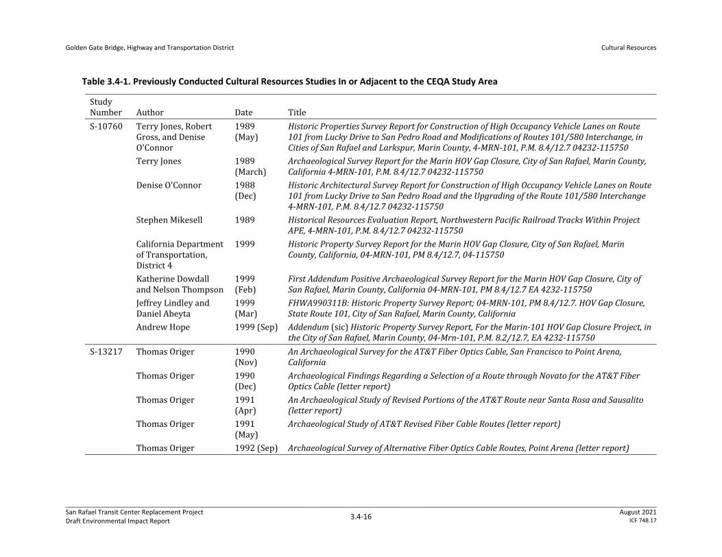
Northwest Information Center Records Search
ICF conducted a record search on May 21, 2020, at the Northwest Information Center (NWIC) in
Rohnert Park, California, a part of the California Historic Resource Information System. This review
identified 34 cultural resources studies that cover areas within or adjacent to the CEQA study area,
as listed in Table 3.4-1.
Golden Gate Bridge, Highway and Transportation District
Cultural Resources
San Rafael Transit Center Replacement Project Draft Environmental Impact Report
3.4-16 August 2021
ICF 748.17
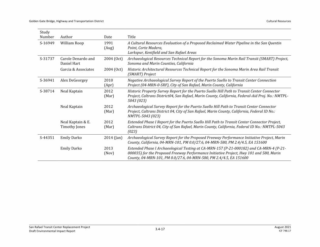
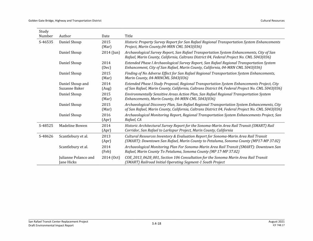
Table 3.4-1. Previously Conducted Cultural Resources Studies In or Adjacent to the CEQA Study Area
Study Number Author Date Title
S-10760 Terry Jones, Robert Gross, and Denise O'Connor
1989 (May)
Historic Properties Survey Report for Construction of High Occupancy Vehicle Lanes on Route 101 from Lucky Drive to San Pedro Road and Modifications of Routes 101/580 Interchange, in Cities of San Rafael and Larkspur, Marin County, 4-MRN-101, P.M. 8.4/12.7 04232-115750
Terry Jones 1989 (March)
Archaeological Survey Report for the Marin HOV Gap Closure, City of San Rafael, Marin County, California 4-MRN-101, P.M. 8.4/12.7 04232-115750
Denise O'Connor 1988 (Dec)
Historic Architectural Survey Report for Construction of High Occupancy Vehicle Lanes on Route 101 from Lucky Drive to San Pedro Road and the Upgrading of the Route 101/580 Interchange 4-MRN-101, P.M. 8.4/12.7 04232-115750
Stephen Mikesell 1989 Historical Resources Evaluation Report, Northwestern Pacific Railroad Tracks Within Project APE, 4-MRN-101, P.M. 8.4/12.7 04232-115750
California Department of Transportation, District 4
1999 Historic Property Survey Report for the Marin HOV Gap Closure, City of San Rafael, Marin County, California, 04-MRN-101, PM 8.4/12.7, 04-115750
Katherine Dowdall and Nelson Thompson
1999 (Feb)
First Addendum Positive Archaeological Survey Report for the Marin HOV Gap Closure, City of San Rafael, Marin County, California 04-MRN-101, PM 8.4/12.7 EA 4232-115750
Jeffrey Lindley and Daniel Abeyta
1999 (Mar)
FHWA990311B: Historic Property Survey Report; 04-MRN-101, PM 8.4/12.7. HOV Gap Closure, State Route 101, City of San Rafael, Marin County, California
Andrew Hope 1999 (Sep) Addendum (sic) Historic Property Survey Report, For the Marin-101 HOV Gap Closure Project, in the City of San Rafael, Marin County, 04-Mrn-101, P.M. 8.2/12.7, EA 4232-115750
S-13217 Thomas Origer 1990 (Nov)
An Archaeological Survey for the AT&T Fiber Optics Cable, San Francisco to Point Arena, California
Thomas Origer 1990 (Dec)
Archaeological Findings Regarding a Selection of a Route through Novato for the AT&T Fiber Optics Cable (letter report)
Thomas Origer 1991 (Apr)
An Archaeological Study of Revised Portions of the AT&T Route near Santa Rosa and Sausalito (letter report)
Thomas Origer 1991 (May)
Archaeological Study of AT&T Revised Fiber Cable Routes (letter report)
Thomas Origer 1992 (Sep) Archaeological Survey of Alternative Fiber Optics Cable Routes, Point Arena (letter report)
Golden Gate Bridge, Highway and Transportation District
Cultural Resources
San Rafael Transit Center Replacement Project Draft Environmental Impact Report
3.4-17 August 2021
ICF 748.17
Study Number Author Date Title
S-16949 William Roop 1991 (Aug)
A Cultural Resources Evaluation of a Proposed Reclaimed Water Pipeline in the San Quentin Point, Corte Madera, Larkspur, Kentfield and San Rafael Areas
S-31737 Carole Denardo and Daniel Hart
2004 (Oct) Archaeological Resources Technical Report for the Sonoma Marin Rail Transit (SMART) Project, Sonoma and Marin Counties, California
Garcia & Associates 2004 (Oct) Historic Architectural Resources Technical Report for the Sonoma Marin Area Rail Transit (SMART) Project
S-36941 Alex DeGeorgey 2010 (Apr)
Negative Archaeological Survey Report of the Puerto Suello to Transit Center Connection Project (04-MRN-0-SRF), City of San Rafael, Marin County, California
S-38714 Neal Kaptain 2012 (Mar)
Historic Property Survey Report for the Puerto Suello Hill Path to Transit Center Connector Project, Caltrans District04, San Rafael, Marin County, California, Federal-Aid Proj. No.: NMTPL-5043 (023)
Neal Kaptain 2012 (Mar)
Archaeological Survey Report for the Puerto Suello Hill Path to Transit Center Connector Project, Caltrans District 04, City of San Rafael, Marin County, California, Federal ID No.: NMTPL-5043 (023)
Neal Kaptain & E. Timothy Jones
2012 (Mar)
Extended Phase I Report for the Puerto Suello Hill Path to Transit Center Connector Project, Caltrans District 04, City of San Rafael, Marin County, California, Federal ID No.: NMTPL-5043 (023)
S-44351 Emily Darko 2014 (Jan) Archaeological Survey Report for the Proposed Freeway Performance Initiative Project, Marin County, California, 04-MRN-101, PM 0.0/27.6, 04-MRN-580, PM 2.4/4.5, EA 151600
Emily Darko 2013 (Nov)
Extended Phase I Archaeological Testing at CA-MRN-157 (P-21-000182) and CA-MRN-4 (P-21-000035) for the Proposed Freeway Performance Initiative Project, Hwy 101 and 580, Marin County, 04-MRN-101, PM 0.0/27.6, 04-MRN-580, PM 2.4/4.5, EA 151600
Golden Gate Bridge, Highway and Transportation District
Cultural Resources
San Rafael Transit Center Replacement Project Draft Environmental Impact Report
3.4-18 August 2021
ICF 748.17
Study Number Author Date Title
S-46535 Daniel Shoup 2015 (Mar)
Historic Property Survey Report for San Rafael Regional Transportation System Enhancements Project, Marin County,04-MRN CML 5043(036)
Daniel Shoup 2014 (Jun) Archaeological Survey Report, San Rafael Transportation System Enhancements, City of San Rafael, Marin County, California, Caltrans District 04, Federal Project No. CML 5043(036)
Daniel Shoup 2014 (Dec)
Extended Phase I Archaeological Survey Report, San Rafael Regional Transportation System Enhancement, City of San Rafael, Marin County, California, 04-MRN CML 5043(036)
Daniel Shoup 2015 (Mar)
Finding of No Adverse Effect for San Rafael Regional Transportation System Enhancements, Marin County, 04-MRNCML 5043(036)
Daniel Shoup and Suzanne Baker
2014 (Aug)
Extended Phase I Study Proposal, Regional Transportation System Enhancements Project, City of San Rafael, Marin County, California, Caltrans District 04, Federal Project No. CML 5043(036)
Daniel Shoup 2015 (Mar)
Environmentally Sensitive Areas Action Plan, San Rafael Regional Transportation System Enhancements, Marin County, 04-MRN-CML 5043(036)
Daniel Shoup 2015 (Mar)
Archaeological Discovery Plan, San Rafael Regional Transportation System Enhancements, City of San Rafael, Marin County, California, Caltrans District 04, Federal Project No. CML 5043(036)
Daniel Shoup 2016 (Apr)
Archaeological Monitoring Report, Regional Transportation System Enhancements Project, San Rafael, CA
S-48525 Madeline Bowen 2014 (Apr)
Historic Architectural Survey Report for the Sonoma-Marin Area Rail Transit (SMART) Rail Corridor, San Rafael to Larkspur Project, Marin County, California
S-48626 Scantlebury et al. 2013 (Apr)
Cultural Resources Inventory & Evaluation Report for Sonoma-Marin Area Rail Transit (SMART): Downtown San Rafael, Marin County to Petaluma, Sonoma County (MP17-MP 37.02)
Scantlebury et al. 2014 (Feb)
Archaeological Monitoring Plan For Sonoma-Marin Area Rail Transit (SMART): Downtown San Rafael, Marin County To Petaluma, Sonoma County (MP 17-MP 37.02)
Julianne Polanco and Jane Hicks
2014 (Oct) COE_2013_0628_001, Section 106 Consultation for the Sonoma Marin Area Rail Transit (SMART) Railroad Initial Operating Segment-1 South Project
Golden Gate Bridge, Highway and Transportation District
Cultural Resources
San Rafael Transit Center Replacement Project Draft Environmental Impact Report
3.4-19 August 2021
ICF 748.17
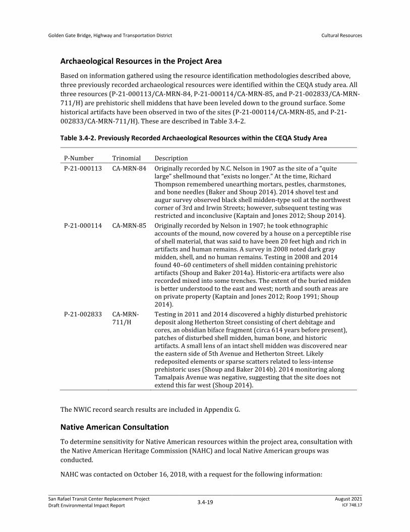
Archaeological Resources in the Project Area
Based on information gathered using the resource identification methodologies described above,
three previously recorded archaeological resources were identified within the CEQA study area. All
three resources (P-21-000113/CA-MRN-84, P-21-000114/CA-MRN-85, and P-21-002833/CA-MRN-
711/H) are prehistoric shell middens that have been leveled down to the ground surface. Some
historical artifacts have been observed in two of the sites (P-21-000114/CA-MRN-85, and P-21-
002833/CA-MRN-711/H). These are described in Table 3.4-2.
Table 3.4-2. Previously Recorded Archaeological Resources within the CEQA Study Area
P-Number Trinomial Description
P-21-000113 CA-MRN-84 Originally recorded by N.C. Nelson in 1907 as the site of a “quite large” shellmound that “exists no longer.” At the time, Richard Thompson remembered unearthing mortars, pestles, charmstones, and bone needles (Baker and Shoup 2014). 2014 shovel test and augur survey observed black shell midden-type soil at the northwest corner of 3rd and Irwin Streets; however, subsequent testing was restricted and inconclusive (Kaptain and Jones 2012; Shoup 2014).
P-21-000114 CA-MRN-85 Originally recorded by Nelson in 1907; he took ethnographic accounts of the mound, now covered by a house on a perceptible rise of shell material, that was said to have been 20 feet high and rich in artifacts and human remains. A survey in 2008 noted dark gray midden, shell, and no human remains. Testing in 2008 and 2014 found 40–60 centimeters of shell midden containing prehistoric artifacts (Shoup and Baker 2014a). Historic-era artifacts were also recorded mixed into some trenches. The extent of the buried midden is better understood to the east and west; north and south areas are on private property (Kaptain and Jones 2012; Roop 1991; Shoup 2014).
P-21-002833 CA-MRN-711/H
Testing in 2011 and 2014 discovered a highly disturbed prehistoric deposit along Hetherton Street consisting of chert debitage and cores, an obsidian biface fragment (circa 614 years before present), patches of disturbed shell midden, human bone, and historic artifacts. A small lens of an intact shell midden was discovered near the eastern side of 5th Avenue and Hetherton Street. Likely redeposited elements or sparse scatters related to less-intense prehistoric uses (Shoup and Baker 2014b). 2014 monitoring along Tamalpais Avenue was negative, suggesting that the site does not extend this far west (Shoup 2014).
The NWIC record search results are included in Appendix G.
Native American Consultation
To determine sensitivity for Native American resources within the project area, consultation with
the Native American Heritage Commission (NAHC) and local Native American groups was
conducted.
NAHC was contacted on October 16, 2018, with a request for the following information:
Golden Gate Bridge, Highway and Transportation District
Cultural Resources
San Rafael Transit Center Replacement Project Draft Environmental Impact Report
3.4-20 August 2021
ICF 748.17
• CEQA Tribal Consultation List (AB 52)
• Identification by NAHC of any Native American resources within the subject lands that are listed
in the Sacred Lands File
A response from NAHC was received on October 29, 2018, and stated that a search of the Sacred
Lands File did not identify any sites; however, the letter specified that the area is sensitive for
potential tribal resources.
The response from NAHC included the following individuals and tribal representatives who might
have an interest in the proposed project:
• Gene Buvelot, Federated Indians of Graton Rancheria
• Greg Sarris, Chairperson, Federated Indians of Graton Rancheria
These individuals were contacted to initiate consultation under AB 52 if desired. Certified letters
were mailed via priority mail on November 7, 2018. No responses were received from any of the
contacts.
Review of City of San Rafael Planning Division and San Rafael Heritage Files
Between August 2018 and January 2021, ICF architectural historians consulted with staff members
from the City of San Rafael Planning Division as well as members of San Rafael Heritage regarding
past built-environment resource surveys and evaluation efforts that have occurred in the CEQA
study area. City of San Rafael staff provided ICF with records from the 1976–1978 San Rafael
Historical/Architectural Survey (City of San Rafael 1986), as well as additional evaluations of the
Whistlestop building at 930 Tamalpais Avenue that are not held by NWIC. San Rafael Heritage
provided materials prepared in 2020 to support a local landmark designation application for the
NWP Railroad Depot at 930 Tamalpais Avenue. These materials informed the built-environment
resource evaluation efforts that ICF conducted in support of the Draft Environmental Impact Report
(EIR).
Historic Map Review
Historic aerials, topographic maps, and geologic maps were consulted to determine potential
sensitivity with respect to encountering buried historic-era archaeological resources within the
project site.
The town of San Rafael was incorporated in 1874, 57 years after the founding of Mission San Rafael
Arcángel. An 1850 map shows a cluster of eight buildings labeled the “Mission de San Rafael” to the
south of San Rafael Creek (Ringgold and Stuart 1852). By 1873, the San Quentin and San Rafael
Railroad and the San Rafael Turnpike extended to San Rafael and continued north to Novato (Austin
and Whitney 1873). The North Pacific Coast Railroad had a terminus in San Rafael, near the San
Quentin and San Rafael Railroad, but the two do not appear to be connected. At that time there were
a number of streets within the town, which began to the west of the farthest extent of the swamp
surrounding San Rafael Creek. The railroad and turnpike appear to have maintained their positions
over the years, with the project area crossing that alignment. By the turn of the century, San Rafael’s
city center had a well-developed street grid with over 100 buildings and San Rafael Creek had been
channeled away from the town (USGS 1897). Throughout the 20th century, the creek and
surrounding swamp continued to be channeled and drained to make room for additional
development as San Rafael expanded to the southeast (USCGS 1926; USGS 1941). Mid-20th century
Golden Gate Bridge, Highway and Transportation District
Cultural Resources
San Rafael Transit Center Replacement Project Draft Environmental Impact Report
3.4-21 August 2021
ICF 748.17
aerial photos show that most of the town was residential in character (Aerial Archives 2020). There
were some government buildings to the west of the turnpike and industrial areas in the
southeastern quarter near the railroad, turnpike, and water. There were several open lots in areas
around the creek that were reclaimed by the swamp. The presence of historic-era development
suggests an increased potential to encounter previously unrecorded historic-era archaeological
resources during project-related ground disturbance.
Built Environment Resources in the Project Area
The following section presents details regarding the built environment resources in the project area
that qualify as historical resources under CEQA. As described in the introduction to this section, a
property is considered a historical resource under CEQA if it is listed in or formally determined
eligible for listing in the CRHR; is included in an adopted local register; is identified as significant in
a qualifying historical resource survey; or is otherwise determined by the CEQA lead agency to be
historically significant. This overview of built environment resources first describes the historical
resource identification efforts that occurred prior to the preparation of this Draft EIR, and then
presents information on the supplemental survey that ICF conducted to support the assessment of
potential impacts in the Draft EIR.
San Rafael Historical/Architectural Survey
Between 1976 and 1978, the City of San Rafael and consultant Charles Hall Page & Associates
undertook a built environment survey of select properties in San Rafael; this effort is known as the
San Rafael Historical/Architectural Survey. Investigators recorded resources on Historical/
Architectural Survey Forms and Department of Parks and Recreation (DPR) Historic Resource
Inventory forms and assigned ratings of “Good,” “Excellent,” and “Exceptional” to all surveyed
resources.
The San Rafael Historical/Architectural Survey included five properties in the CEQA study area, to
which investigators assigned ratings of “Good” or “Excellent”:
• 633 5th Avenue
• 637 5th Avenue
• 927 Tamalpais Avenue (Barrel House)
• 930 Tamalpais (NWP Depot)
• 709–711 4th Street (Tavern on Fourth)1
The City selected 16 individual resources and three historic districts identified in the survey to be
added to the local register of historical resources. None of the resources in the CEQA study area is
among the locally listed resources. The City administratively updated the survey in 1986 but did not
revise any of the survey forms completed in the 1970s. The remaining properties on the list that
were not designated as landmarks are considered “potential historic resources” (City of San Rafael
1986, 2020c:1-1).
1 Note that the CEQA study area includes 709–711 4th Street because a portion of its parcel overlaps the project footprint. However, the project does not propose to physically alter the building at 709–711 4th Street.
Golden Gate Bridge, Highway and Transportation District
Cultural Resources
San Rafael Transit Center Replacement Project Draft Environmental Impact Report
3.4-22 August 2021
ICF 748.17
The City of San Rafael Planning Division’s environmental review procedures specify that any
resource recorded in the San Rafael Historical/Architectural Survey “must be presumed a significant
[historical] resource, unless evidence to the contrary is provided” (City of San Rafael 2015).
2019–2020 Downtown San Rafael Precise Plan Historic Resources Survey
During 2019 and 2020, the City conducted a built environment survey to inform the preparation of
the Downtown San Rafael Precise Plan. Building upon the findings of the 1970s San Rafael Historical/
Architectural Survey, the Downtown San Rafael Precise Plan Historic Resources Survey reviewed past
survey evaluations of built-environment resources in the Downtown San Rafael Precise Plan area.
This area encompasses the entirety of the CEQA study area established for the current investigation.
The 2019–2020 survey involved a review of 572 parcels in the plan area and identified two
landmark register-worthy historic districts: the West Downtown Core Historic District and East
Downtown Core Historic District. (Neither of these eligible districts overlaps with the CEQA study
area.) Approximately 160 properties in the plan area received one of the following five preliminary
ratings:
• A: Eligible for consideration as local landmarks
• B: Likely not eligible individually but could be considered eligible as contributing resources in a
historic district
• C: Require additional research
• D: Likely ineligible
• E: Ineligible as local landmarks
The preliminary ratings are not final and are intended to inform further investigation rather than
determine CEQA historical resource status. Several buildings in the CEQA study area received
preliminary ratings of A through E, which are presented below in Table 3.4-3.
Following this preliminary review, the City selected approximately 40 built-environment resources
for intensive-level survey and evaluation. For each of the selected built-environment resources,
investigators completed a DPR 523-series form set that documents a new evaluation of the resource
for eligibility for listing in the NRHP and CRHR. One building in the CEQA study area, the residence
at 1011 Irwin Street, was documented on a DPR form set as part of the 2019–2020 survey. The City
found the residence to qualify for listing in the NRHP and CRHR and assigned it a California
Historical Resource Status (CHRS) code of 3S, “Appears eligible for the NRHP as an individual
property through survey evaluation.” Therefore, 1011 Irwin Street meets the definition of a CEQA
historical resource (City of San Rafael 2020c; Morgan and Brunzell 2020).
Additional Previous Evaluations
In addition to the built-environment surveys described above, various past investigations have
recorded and evaluated the following built-environment resources within the project area:
• 703–705 4th Street: Garcia and Associates recorded this two-story commercial building in 2004
as part of the SMART Historic Architectural Resources Inventory and Evaluation and assigned it
a CHRS code of 6Z: found ineligible for NRHP, CRHR, or local designation through survey
evaluation. The 2004 evaluation found the building not to be a historical resource for the
purposes of CEQA (GANDA 2004b).
Golden Gate Bridge, Highway and Transportation District
Cultural Resources
San Rafael Transit Center Replacement Project Draft Environmental Impact Report
3.4-23 August 2021
ICF 748.17
• Northwestern Pacific Railroad: The alignment of the NWP generally follows Tamalpais Avenue
through Downtown San Rafael and the project area. Historically, this rail alignment entered
Marin County north of Novato and continued south through San Rafael to terminate at Point
Tiburon. To support past cultural resource studies, numerous investigators have evaluated
segments of the NWP in Marin, Sonoma, Mendocino, and Humboldt Counties. In Marin County,
investigators recorded and evaluated segments of the rail alignment and associated features
(such as trestles and tunnels) under the primary number P-21-002618. In 2014, Patricia
Ambacher of AECOM recorded the 1-mile-long segment of the NWP between Anderson Drive
and 4th Street in San Rafael, which includes the portion of the rail alignment in the project area.
AECOM’s 2014 evaluation found the recorded segment ineligible for listing in the NRHP and the
CRHR, and assigned the rail alignment a CHRS code of 6Z (AECOM 2014). With regard to the
current investigation, the rail alignment does not meet the definition of a CEQA historical
resource.
• Northwestern Pacific Railroad Depot: Surveyors recorded the NWP Railroad Depot at 730
Tamalpais Avenue (also known as the Whistlestop, after its current tenant) during the San
Rafael Historical/Architectural Survey and assigned the building a rating of “Good” (City of San
Rafael 1986). However, the property owner substantially altered the NWP Railroad Depot after
its initial recordation in the 1970s, and subsequent evaluations have reassessed the significance
and integrity of the building. JRP Historical Consulting recorded the NWP Railroad Depot in
2012 and presented an assessment of the building’s CEQA historical resource status, as defined
in the CEQA statute (PRC Section 5024.1) and the State CEQA Guidelines. The 2012 JRP
evaluation ultimately concluded that the NWP Railroad Depot does not qualify as a historical
resource under CEQA (JRP Historical Consulting 2012). ICF International subsequently
evaluated the building in 2013 as ineligible for listing in the NRHP and CRHR but incorrectly
stated the building is listed in the local historic register, which would qualify it as a CEQA
historical resource (ICF International 2013). Various additional investigators have commented
upon the past evaluations of the NWP Railroad Depot. It received a preliminary rating of “E”
(ineligible for landmark status) in the 2019–2020 Downtown San Rafael Precise Plan Historic
Resources Survey. Furthermore, San Rafael Heritage prepared a site record for the NWP Railroad
Depot in 2020 that found the building eligible for listing in the CRHR under Criterion 1 (Events)
(San Rafael Heritage 2020). In order to clarify the record regarding the historical resource status
of the depot building, ICF has prepared an updated evaluation of this building for the San Rafael
Transit Center Replacement Project Survey, which is included in Appendix F. In consideration of
the record of past evaluations, ICF found the building not to be eligible for listing in the CRHR
due to diminished integrity, and not to qualify as a CEQA historical resource.
• San Rafael Viaduct: The California Department of Transportation (Caltrans) State and Local
Bridge Survey (1989 and updates) revealed that two bridges that cross through the project area
were previously evaluated through the Caltrans historic bridge inventory and identified as
Category 5 bridges (not eligible for listing in the NRHP). These bridges comprise the northbound
and southbound structures of the San Rafael Viaduct (Caltrans Bridge Nos. 27 0035R and 27
0035L, respectively), which carries US-101 along the eastern edge of Downtown San Rafael. In
addition to the Category 5 rating recorded in the Caltrans State and Local Bridge Survey,
Caltrans evaluated the 1941-built northbound viaduct structure in 1999 for the Marin-101 High-
Occupancy Vehicle Gap Closure Project and determined that it does not meet the definition of a
historical resource under CEQA. The 1999 Caltrans evaluation assigned the northbound San
Rafael Viaduct structure a CHRS code of 6Z (Caltrans 1999, 2018).
Golden Gate Bridge, Highway and Transportation District
Cultural Resources
San Rafael Transit Center Replacement Project Draft Environmental Impact Report
3.4-24 August 2021
ICF 748.17
San Rafael Transit Center Replacement Project Survey
In 2020 and 2021, ICF conducted a supplemental survey of built-environment resources to develop
a comprehensive historical resource inventory of all built properties within the CEQA study area, in
support of the current investigation. ICF reviewed the findings of the San Rafael Historical/
Architectural Survey, 2019–2020 Downtown San Rafael Precise Plan Historic Resources Survey, and
additional past evaluation efforts. Several of the historic-aged properties (more than 45 years old) in
the CEQA study area have a valid historical resource status under CEQA based on past surveys and
evaluations. However, six historic-aged properties had never previously been recorded in a built-
environment survey or otherwise evaluated for listing in the NRHP or CRHR.
ICF surveyed all six previously unrecorded built-environment resources in the project area and
documented CRHR evaluations for each one on a DPR 523A (Primary Record) and 523B (Building,
Structure, Object Record) form set:
• 638 4th Street
• 610 4th Street
• 1001 Irwin Street
• 1015 Irwin Street
• 915–917 Irwin Street
• 615 4th Street
ICF also documented a new CRHR evaluation of the building at 927 Tamalpais Avenue; this building
received a rating of “Good” in the San Rafael Historical/Architectural Survey, but it has undergone
alterations since its original recordation. 927 Tamalpais Avenue received a preliminary rating of “B”
in the Downtown San Rafael Precise Plan Historic Resources Survey (does not appear individually
eligible as a landmark but could be considered a district contributor) but did not receive an
individual updated CRHR evaluation in that effort. Despite that the building received a rating of
“Good” in the San Rafael Historical/Architectural Survey during the late 1970s, ICF’s updated
evaluation of 927 Tamalpais Avenue found it has been altered since its construction, lacks direct
association with events of historical significance, and does not meet the eligibility requirements of
the CRHR.
Furthermore, ICF completed a DPR Update form for the NWP Depot at 930 Tamalpais Avenue, which
has undergone substantial alterations since its original recordation in 1976. The building received a
rating of “Good” in the San Rafael Historical/Architectural Survey, but due to its alterations it has
elicited a range of eligibility findings from previous investigators. ICF’s updated evaluation of 930
Tamalpais Avenue considered the building’s past evaluations and history of alterations and found it
not to meet the eligibility requirements of the CRHR. The DPR form sets ICF completed for the
current survey are included in Appendix F.
In summary, ICF evaluated each of the eight resources recorded or updated in the San Rafael Transit
Center Replacement Project Survey as ineligible for listing in the CRHR.
Three resources in the CEQA study area were evaluated as “Excellent” or “Good” in the San Rafael
Historical/Architectural Survey and also received preliminary “A” ratings in the Downtown San
Rafael Precise Plan Historic Resources Survey: 633 5th Avenue, 637 5th Avenue, and 709–711 4th
Street (whose parcel partially overlaps the project footprint). Because these resources have existing
Golden Gate Bridge, Highway and Transportation District
Cultural Resources
San Rafael Transit Center Replacement Project Draft Environmental Impact Report
3.4-25 August 2021
ICF 748.17
survey evaluations that establish their significant historic/architectural character and do not appear
to have been altered substantially since their previous recordation, ICF did not complete updated
DPR forms for these three resources for the current investigation. These resources, rather, qualify as
CEQA historical resources and are presumed significant for their associations with the early
development of central San Rafael (CRHR Criterion 1, Events) and as good remaining examples of
late-19th-century residential and commercial architecture (CRHR Criterion 3, Architecture/Design).
Summary of Built-Environment Resources in the CEQA Study Area
Based on previous historical resource evaluations as well as updated evaluations prepared for this
Draft EIR, the CEQA study area contains four built-environment resources that qualify as historical
resources for the purposes of CEQA review: 1011 Irwin Street, 709–711 4th Street, 633 5th Avenue,
and 637 5th Avenue. The remaining historic-aged resources in the project area are not eligible for
CRHR listing and do not meet any of the additional qualifying criteria outlined in Section 15064.5(a)
of the State CEQA Guidelines. The historic-aged built-environment resources in the CEQA study area
are listed in Table 3.4-3, which presents each property’s address, Assessor’s Parcel Number(s),
previous designation or evaluation (as applicable), and status as a CEQA historical resource.
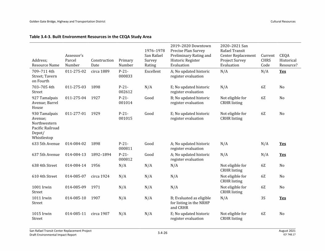
Golden Gate Bridge, Highway and Transportation District
Cultural Resources
San Rafael Transit Center Replacement Project Draft Environmental Impact Report
3.4-26 August 2021
ICF 748.17
Table 3.4-3. Built Environment Resources in the CEQA Study Area
Address; Resource Name
Assessor’s Parcel Number
Construction Date
Primary Number
1976–1978 San Rafael Survey Rating
2019–2020 Downtown Precise Plan Survey Preliminary Rating and Historic Register Evaluation
2020–2021 San Rafael Transit Center Replacement Project Survey Evaluation
Current CHRS Code
CEQA Historical Resource?
709–711 4th Street; Tavern on Fourth
011-275-02 circa 1889 P-21-000833
Excellent A; No updated historic register evaluation
N/A N/A Yes
703–705 4th Street
011-275-03 1898 P-21-002612
N/A E; No updated historic register evaluation
N/A 6Z No
927 Tamalpais Avenue; Barrel House
011-275-04 1927 P-21-001014
Good B; No updated historic register evaluation
Not eligible for CRHR listing
6Z No
930 Tamalpais Avenue; Northwestern Pacific Railroad Depot/Whistlestop
011-277-01 1929 P-21-001015
Good E; No updated historic register evaluation
Not eligible for CRHR listing
6Z No
633 5th Avenue 014-084-02 1898 P-21-000811
Good A; No updated historic register evaluation
N/A N/A Yes
637 5th Avenue 014-084-13 1892–1894 P-21-000812
Good A; No updated historic register evaluation
N/A N/A Yes
638 4th Street 014-084-14 1956 N/A N/A N/A Not eligible for CRHR listing
6Z No
610 4th Street 014-085-07 circa 1924 N/A N/A N/A Not eligible for CRHR listing
6Z No
1001 Irwin Street
014-085-09 1971 N/A N/A N/A Not eligible for CRHR listing
6Z No
1011 Irwin Street
014-085-10 1907 N/A N/A B; Evaluated as eligible for listing in the NRHP and CRHR
N/A 3S Yes
1015 Irwin Street
014-085-11 circa 1907 N/A N/A E; No updated historic register evaluation
Not eligible for CRHR listing
6Z No
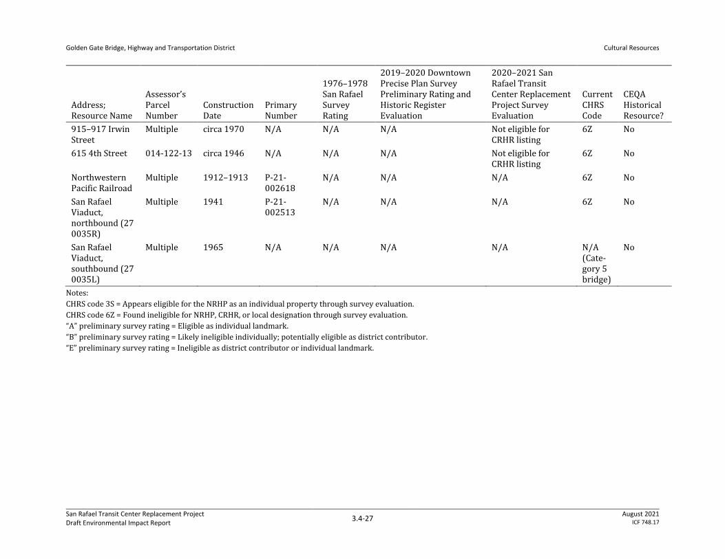
Golden Gate Bridge, Highway and Transportation District
Cultural Resources
San Rafael Transit Center Replacement Project Draft Environmental Impact Report
3.4-27 August 2021
ICF 748.17
Address; Resource Name
Assessor’s Parcel Number
Construction Date
Primary Number
1976–1978 San Rafael Survey Rating
2019–2020 Downtown Precise Plan Survey Preliminary Rating and Historic Register Evaluation
2020–2021 San Rafael Transit Center Replacement Project Survey Evaluation
Current CHRS Code
CEQA Historical Resource?
915–917 Irwin Street
Multiple circa 1970 N/A N/A N/A Not eligible for CRHR listing
6Z No
615 4th Street 014-122-13 circa 1946 N/A N/A N/A Not eligible for CRHR listing
6Z No
Northwestern Pacific Railroad
Multiple 1912–1913 P-21-002618
N/A N/A N/A 6Z No
San Rafael Viaduct, northbound (27 0035R)
Multiple 1941 P-21-002513
N/A N/A N/A 6Z No
San Rafael Viaduct, southbound (27 0035L)
Multiple 1965 N/A N/A N/A N/A N/A (Cate-gory 5 bridge)
No
Notes:
CHRS code 3S = Appears eligible for the NRHP as an individual property through survey evaluation.
CHRS code 6Z = Found ineligible for NRHP, CRHR, or local designation through survey evaluation.
“A” preliminary survey rating = Eligible as individual landmark.
“B” preliminary survey rating = Likely ineligible individually; potentially eligible as district contributor.
“E” preliminary survey rating = Ineligible as district contributor or individual landmark.
Golden Gate Bridge, Highway and Transportation District
Cultural Resources
San Rafael Transit Center Replacement Project Draft Environmental Impact Report
3.4-28 August 2021
ICF 748.17
3.4.2.2 Thresholds of Significance
The following State CEQA Guidelines Appendix G thresholds identify significance criteria to be
considered for determining whether a project could have significant impacts related to cultural
resources.
Would the proposed project:
• Cause a substantial adverse change in the significance of a historical resource pursuant to
Section 15064.5?
• Cause a substantial adverse change in the significance of an archaeological resource pursuant to
Section 15064.5?
• Disturb any human remains, including those interred outside of dedicated cemeteries?
Section 15064.5(b)(1) of the State CEQA Guidelines defines “substantial adverse change to a
historical resource” as “physical demolition, destruction, relocation, or alteration of the resource or
its immediate surroundings such that the significance of the historical resource would be materially
impaired.” Material impairment of a historical resource, as defined in State CEQA Guidelines Section
15064.5(b)(2), occurs when a project “demolishes or materially alters in an adverse manner” those
physical characteristics of the resource that express its significance and justify its inclusion in, or
eligibility for listing in, the CRHR or a qualified local register of historical resources or evaluation as
historically significant in a qualified local survey.
3.4.2.3 Impacts
Cause a Substantial Adverse Change in the Significance of a Historical Resource Pursuant to Section 15064.5
Construction Impacts
Construction of each of the four alternatives would involve varying degrees of physical change (i.e.,
material alteration or demolition) and proximity change (i.e., alterations in setting) to different
identified built-environment historical resources. The following analysis provides a discussion of
potential construction-caused impacts on these resources, organized by alternative.
Move Whistlestop Alternative
Relative to built-environment historical resources, the Move Whistlestop Alternative would involve
the demolition of two historic-aged buildings: 703–705 4th Street and 927 Tamalpais Avenue
(Barrel House). As described in Section 3.4.2.1, Methodology, neither of the historic-aged buildings
proposed for demolition under this alternative qualifies as a historical resource under CEQA. The
Move Whistlestop Alternative also proposes to relocate the Whistlestop building at 930 Tamalpais
Avenue to the west side of Tamalpais Avenue, which is the current location of 703–705 4th Street
and 927 Tamalpais Avenue. The relocated Whistlestop building would be in the vicinity of the
historical resource at 709–711 4th Street, a circa 1889 commercial building. As described in Section
3.4.2.1, Methodology, none of the historic-aged buildings proposed for demolition or relocation
under this alternative qualifies as a historical resource under CEQA. The Move Whistlestop
Golden Gate Bridge, Highway and Transportation District
Cultural Resources
San Rafael Transit Center Replacement Project Draft Environmental Impact Report
3.4-29 August 2021
ICF 748.17
Alternative would utilize the existing alley that leads adjacent to the east façade of 709–711 4th
Street as a vehicular circulation path.
Regarding 709–711 4th Street, project activities would not result in a substantial adverse change in
the significance of this resource as described below. The building is presumed to have significance
under NRHP/CRHR Criteria A/1 (Events) and C/3 (Architecture), as the building is an early and
ornate example of commercial architecture in Downtown San Rafael that conveys both the City’s
19th-century urban development and the characteristics of the Italianate architectural style as
applied to a commercial building.
Project activities would change the setting of the historical resource at 709–711 4th Street to an
extent, as the demolition of 703–705 4th Street (constructed in 1898) would remove a building from
the immediate setting of 709–711 4th Street that is roughly its historical contemporary. Relocation
of the Whistlestop building to the west side of Tamalpais Avenue would bring it within closer
proximity of 709–711 4th Street, which would further alter features within the historic setting of
709–711 4th Street. However, the setting of 709–711 4th Street has changed substantially since its
construction and early use in the late 19th century: the exterior of 703–705 4th Street itself has
been changed to the degree that it no longer represents the historic character of Downtown San
Rafael, and the majority of surrounding parcels contain buildings that appear altered or much more
recently constructed. As a result, the resource at 709–711 4th Street does not rely upon an intact
historical setting to convey its significance; rather, it expresses its significance most directly through
its intact footprint, massing, false-front parapet, boxed bay, cladding materials, and decorative
elements, none of which would be altered by this alternative. The demolition of 703–705 4th Street,
use of the adjacent existing alley for vehicular traffic, and relocation of the Whistlestop building to a
location immediately east of this alley, as proposed under the Move Whistlestop Alternative, would
be broadly consistent with previous changes that have occurred to the building’s setting and would
not damage or destroy the features that qualify 709–711 4th Street as a CEQA historical resource.
The potential for construction-caused groundborne vibration to damage the historical resource at
709–711 4th Street is addressed in Section 3.11, Noise.
As a result, construction of the Move Whistlestop Alternative would have a less-than-significant
impact on built-environment historical resources. No mitigation is required.
Adapt Whistlestop Alternative
The Adapt Whistlestop Alternative would involve similar project activities as the Move Whistlestop
Alternative, as described above. However, the Adapt Whistlestop Alternative proposes to retain the
Whistlestop building at 930 Tamalpais Avenue in its current location east of Tamalpais Avenue. As
under the Move Whistlestop Alternative, the Adapt Whistlestop Alternative would also demolish
703–705 4th Street and 927 Tamalpais Avenue, neither of which qualifies as a CEQA historical
resource. Instead of relocating the Whistlestop building, this alternative would introduce public
plazas, customer service, bicycle parking, and/or other transit facilities west of Tamalpais Avenue,
including on the parcels where 703–705 4th Street and 927 Tamalpais Avenue now stand. This
alternative would also utilize the alley adjacent to 709–711 4th Street for vehicular circulation.
The types and intensity of project activities under this alternative would be similar to those
analyzed above under the Move Whistlestop Alternative. The Adapt Whistlestop Alternative would
not alter the physical features that allow 709–711 4th Street to convey its historical significance. As
described above, an intact historic setting for 709–711 4th Street is not a requisite for the building
Golden Gate Bridge, Highway and Transportation District
Cultural Resources
San Rafael Transit Center Replacement Project Draft Environmental Impact Report
3.4-30 August 2021
ICF 748.17
to convey its historical and architectural significance, which qualifies it as a CEQA historical
resource. Changes in the resource’s setting to the degree proposed under the Adapt Whistlestop
Alternative would not cause a substantial adverse change in its significance. Furthermore, this
alternative would not involve project activities affecting the character-defining features or
significant aspects of setting of any other CEQA historical resource. As a result, construction of the
Adapt Whistlestop Alternative would have a less-than-significant impact on built-environment
historical resources. No mitigation is required.
4th Street Gateway Alternative
The footprint of the 4th Street Gateway Alternative encompasses two buildings that qualify as CEQA
historical resources: 633 5th Avenue and 637 5th Avenue. These buildings face north onto 5th
Avenue within the block between Hetherton Street and East Tamalpais Avenue, occupying a location
where transportation facilities are proposed under this alternative. The alternative intends to
relocate the buildings at 633 5th Avenue and 637 5th Avenue prior to or during construction to
accommodate the proposed transportation facilities. However, there is currently no identified
receiving site for either building, and the methods for conveying the buildings to their new locations
have not yet been determined.
In general terms, the relocation of built-environment historical resources has the potential to cause
an adverse change in their significance in two respects. Firstly, the act of moving a building or
structure to a new location may potentially require disassembly prior to relocation and reassembly
at its receiving site, if necessitated by its size or structural system; relocation could also
inadvertently damage or destroy physical characteristics that contribute to the resource’s
significance. Secondly, relocation of a built-environment historical resource would remove the
resource from its existing location and may move it to a location with a new setting (i.e., immediate
physical context) that is incompatible with the resource’s historic setting. Both location and setting
are aspects of a resource’s historical integrity, which, if intact, assist the resource in conveying its
historical significance. Therefore, diminishing a resource’s integrity of location and setting has the
potential to contribute to material impairment of the resource’s significance.
As information is not currently available regarding measures that would be undertaken to protect or
rehabilitate character-defining features, relocation of the buildings at 633 5th Avenue and 637 5th
Avenue has the potential to cause inadvertent damage to their materials and decorative elements.
Without appropriate protective measures in place, it is possible that racking, vibration, or additional
harmful conditions would be present during relocation that may cause structural or ornamental
damage to the buildings, which may then further damage significant architectural elements and
spaces and diminish the resources’ integrity of materials, workmanship, design, feeling, and
association. Furthermore, there is currently no receiving site for either 633 5th Avenue or 637 5th
Avenue, and it cannot be guaranteed that suitable receiving sites would be identified that are
generally compatible with the resources’ historic setting (a residential neighborhood on the edge of
San Rafael’s Downtown commercial district).
The construction of new transportation facilities under this alternative would involve changes to the
eastern end of Downtown San Rafael, adjacent to the viaduct carrying US-101. This area currently
accommodates commercial and transportation-related uses, and construction of the alternative
appears to be generally consistent with the continuum of change that has already occurred to this
edge of the Downtown district over the past century or more. Consequently, it does not appear that
the significance of any nearby historical resource is dependent upon the current conditions of the
Golden Gate Bridge, Highway and Transportation District
Cultural Resources
San Rafael Transit Center Replacement Project Draft Environmental Impact Report
3.4-31 August 2021
ICF 748.17
site (including the residences at 633 5th Avenue and 637 5th Avenue standing in their historic
locations). It is not anticipated that construction of the alternative would lead to changes in the
setting of any nearby historical resource that would diminish that resource’s ability to convey its
historical or architectural significance.
However, as a result of the potential for inadvertent damage to 633 5th Avenue and 637 5th Avenue
during relocation of the residences, as well as the current lack of receiving sites that would ensure
successful relocation, the proposed project has the potential to materially alter physical
characteristics and aspects of setting that qualify the two buildings as CEQA historical resources.
Therefore, construction of the 4th Street Gateway Alternative would result in a significant impact
on built-environment historical resources. Mitigation Measures MM-CULT-CNST-1, MM-CULT-CNST-
2, and MM-CULT-CNST-3 are presented below to reduce the level of the identified impact. Even with
the implementation of Mitigation Measure MM-CULT-CNST-1, the proposed project could not ensure
that appropriate receiving sites would be available for the buildings proposed for relocation under
the 4th Street Gateway Alternative. Depending on the outcome of efforts to identify receiving sites
and further investigations on the feasibility of building relocation, Mitigation Measures MM-CULT-
CNST-2 and MM-CULT-CNST-3 may also be required to document the current conditions of affected
historical resources and to commemorate their historical significance for the public. The Under the
Freeway Alternative would also require implementation of Mitigation Measures MM-CULT-CNST-2
and MM-CULT-CNST-3 to compensate for the loss of the residence at 1011 Irwin Street. However,
these measures would not be enough to avoid, rectify, reduce, or compensate for the potential loss
of the historical resources. Because loss of the resources could still occur, the impact of construction
of the 4th Street Gateway Alternative and Under the Freeway Alternative on built environment
historical resources would remain significant and unavoidable after the application of mitigation.
Under the Freeway Alternative
One CEQA historical resource is within the footprint of the Under the Freeway Alternative: the
residence at 1011 Irwin Street. The City has evaluated the residence as eligible for listing in the
NRHP and CRHR under Criteria C/3 (Architecture/Design) as an excellent example of a hipped-roof
cottage. This alternative would demolish this historical resource, thus destroying all the
characteristics that qualify it for inclusion in the NRHP and CRHR. The demolition of 1011 Irwin
Street would therefore be considered a substantial adverse change in the significance of the
historical resource.
Construction of the Under the Freeway Alternative would introduce transportation facilities
underneath and east of the US-101 viaduct, where such facilities do not currently exist. The
alternative would entail the removal of three buildings historically used as residences (610 4th
Street, 1011 Irwin Street, and 1015 Irwin Street) in addition to commercial establishments on Irwin
Street and 4th Street. This would represent a relatively minor change in the setting of nearby
historical resources, including the French Quarter Historic District at the intersection of Irwin Street
and 3rd Street. Construction of transportation facilities under this alternative is not anticipated to
change the setting of any built-environment historical resources in the vicinity to the extent that the
significance of those resources would be materially impaired.
Due to the proposed demolition of 1011 Irwin Street, however, construction of the Under the
Freeway Alternative would result in a significant and unavoidable impact on built-environment
historical resources. Mitigation Measures MM-CULT-CNST-1, MM-CULT-CNST-2, and MM-CULT-
Golden Gate Bridge, Highway and Transportation District
Cultural Resources
San Rafael Transit Center Replacement Project Draft Environmental Impact Report
3.4-32 August 2021
ICF 748.17
CNST-3 are presented below to reduce the level of the identified impact but would not be able to
reduce impacts to a less-than-significant level.
Operations Impacts
All Build Alternatives
Under all alternatives, operations of the San Rafael Transit Center would occur in the vicinity of
historical resources near the eastern edge of Downtown San Rafael. Operations would not involve
physical changes to any historical resources beyond those required for the construction of the four
alternatives but would introduce new visual, audible, and atmospheric elements in the vicinity of
those resources. Hypothetically speaking, circumstances could exist in which visual, audible, and
atmospheric elements lead to the diminishment of a historical resource’s integrity. For instance, it is
possible that long-term, intermittent increases in noise and vibration resulting from the operations
of a transportation facility might compel individuals to abandon a historical resource (such as a
residence or commercial building). Such an act would constitute an indirect impact if it were to
result in neglect of a resource’s physical features that convey significance, which over time could
diminish integrity of design, materials, workmanship, feeling, and association.
As described in Section 3.11, Noise, increases in operations-caused noise and vibration would not be
substantive, and the intensity of transportation activities would not be substantially different from
current conditions. As such, it is not anticipated that abandonment and neglect of historical
resources would reasonably occur as an effect of project operation. Furthermore, no historical
resources identified for the current investigation appear to rely upon a quiet setting to convey their
significance. The negligible degree of change in the audible and atmospheric conditions of historical
resources in Downtown San Rafael is not anticipated to diminish the historical integrity of any
identified built-environment historical resource and would not constitute material impairment of its
significance.
Therefore, operations of the proposed project would have no impact on built-environment
historical resources under all four alternatives. No mitigation is required.
Mitigation Measures
MM-CULT-CNST-1: Prepare and Implement Relocation Plans
The Golden Gate Bridge, Highway and Transportation District (District) shall retain a qualified
historical architect who meets the Secretary of the Interior’s Professional Qualification
Standards (36 Code of Federal Regulations, Part 61) to prepare a relocation plan for any
historical resource that the selected alternative could move in order to avoid demolition of the
resource. The documentation shall be reviewed and approved by the District prior to the
issuance of any demolition, site, or building permit for the resource proposed for relocation.
The relocation plan shall be reviewed and approved by the District and Planning Division to
ensure that character-defining features of the buildings will be retained. This review shall occur
prior to the commencement of any construction activities at the site. The relocation plan shall
include required qualifications for the building relocation company to ensure that relocation is
undertaken by a company that is experienced in moving historic buildings of a similar size
and/or structural system as the subject buildings. The relocation plan shall ensure that the
resource will be moved without irreparable damage to its character-defining historic fabric, and
Golden Gate Bridge, Highway and Transportation District
Cultural Resources
San Rafael Transit Center Replacement Project Draft Environmental Impact Report
3.4-33 August 2021
ICF 748.17
will specify protective measures for vulnerable character-defining features. The District will
incorporate into construction specifications for the proposed project a requirement that the
construction contractor(s) use all feasible means to avoid damage to historical resources during
relocation including, but not limited to, relocation methods and relocation activity routes,
closures, and timing.
By requiring protective measures during the relocation of a built-environment historical
resource, implementation of Mitigation Measure MM-CULT-CNST-1 would prevent inadvertent
damage to the resource and would therefore avert further potential impacts on its integrity of
design, materials, workmanship, feeling, and association. Implementation of Mitigation Measure
MM-CULT-CNST-1 would ensure that historical resources retain their extant character-defining
features following relocation, such that relocation could be implemented as described to
preserve significant architectural qualities that justify the resources’ status as CEQA historical
resources. However, implementation of Mitigation Measure MM-CULT-CNST-1 would not reduce
potential impacts from relocation to a less-than-significant level because the relocation plan
could not guarantee that an appropriate receiving site would be identified and acquired prior to
project construction. It therefore remains possible that, if no relocation site is secured, the
proposed project would require the demolition of historical resources, which would represent a
substantial adverse change in their significance.
Should the relocation of any historical resource prove to be infeasible due to structural issues or
lack of receiving site, the current analysis assumes the resource would be demolished to
accommodate project construction. The following additional two measures would be applicable
for each historical resource to be demolished:
MM-CULT-CNST-2: Prepare and Submit Historical Documentation
The District shall retain a professional who meets the Secretary of the Interior’s Qualification
Standards for Architectural Historian or Historian (36 Code of Federal Regulations Part 61) and
a photographer with demonstrated experience in Historic American Buildings Survey (HABS)
photography to prepare written and photographic documentation for the historical resource
proposed for demolition. The HABS documentation package for the resource shall be reviewed
and approved by the staff of the Planning Division, or professionally qualified Architectural
Historian or Historian hired by the City, prior to the issuance of any demolition, site, or
construction permit for the proposed project. Documentation may be used in the interpretive
display or signage described in Mitigation Measure MM-CULT-CNST-3.
The documentation shall consist of the following:
⚫ Historic American Buildings Survey–level Photographs: HABS standard high-resolution digital
photography shall be undertaken to document each historical resource and its surrounding
context. Large-format negatives are not required. The scope and number of photographs
shall be reviewed and approved by the staff of the Planning Division or their professionally
qualified contractor prior to documentation, and all photography shall be conducted
according to the current National Park Service HABS standards.
The photograph set shall include the following: distant views to capture the extent and
context of the resource, contextual views of each façade of the building, façade details
showing the character-defining exterior features of the building, and general interior
views documenting current interior conditions.
Golden Gate Bridge, Highway and Transportation District
Cultural Resources
San Rafael Transit Center Replacement Project Draft Environmental Impact Report
3.4-34 August 2021
ICF 748.17
All views shall be referenced on a key map of the resource that includes a photograph
number with an arrow to indicate the direction of the view.
The draft photograph contact sheets and key map shall be provided to the Planning
Division or its professionally qualified contractor for review and approval to determine
the final number of photographs and views for inclusion in the final dataset.
⚫ Written Historic American Buildings Survey Narrative Report: A written historical narrative
shall be prepared in accordance with HABS Historical Report Guidelines. The level of
documentation will be subject to approval of the Planning Division or its professionally
qualified contractor. Historic photographs identified in previous studies and updated
research shall also be collected, scanned as high-resolution digital files, and reproduced in
the dataset.
Format of Final Dataset:
⚫ The project sponsor shall contact San Rafael Heritage, Marin History Museum, Anne T. Kent
California Room of the Marin County Free Library, and NWIC to inquire as to whether the
repository or organization would like to receive a hard or digital copy of the final dataset.
Labeled hard copies and/or digital copies of the final photograph sets and narrative report
shall be provided to these repositories in their preferred format.
MM-CULT-CNST-3: Develop and Implement an Interpretive Program
For each historical resource to be demolished, the District shall also install and maintain a
permanent onsite interpretive display commemorating the historical significance of the
demolished building. The interpretive program must, at a minimum, include one display board
containing narrative and visual materials to interpret the history of the building. The display
board shall contain historical photos of the building, if available, and a description of its
historical significance in a publicly accessible location on the project site. The interpretive
display can also feature interactive or dynamic media, such as video. Development of the
interpretive display shall be overseen by a qualified professional who meets the Secretary of the
Interior’s Professional Qualification Standards (36 Code of Federal Regulations Part 61) for
Historian or Architectural Historian.
Cause a Substantial Adverse Change in the Significance of an Archaeological Resource Pursuant to Section 15064.5
Construction
Construction of any of the four build alternatives would likely affect archaeological resources. Two
pre-contact archaeological sites (P-21-000113/CA-MRN-84 and P-21-000114/CA-MRN-85) are to
the east of the freeway and one pre-contact archaeological site is just west of the freeway (P-21-
002833/CA-MRN-711/H). The presence of these sites suggests that ground disturbance associated
with project construction has the potential to encounter as-yet-undocumented archaeological
resources, which would result in potentially significant impacts. These impacts would be reduced to
a less-than-significant level with the implementation of the mitigation measures outlined below.
All build alternatives would involve the removal of existing storm drain infrastructure and the
installation of new inlets, manholes, and bioretention facilities. Utilities, including traffic signal
poles, streetlights, and fire hydrants, would need to be relocated and/or removed.
Golden Gate Bridge, Highway and Transportation District
Cultural Resources
San Rafael Transit Center Replacement Project Draft Environmental Impact Report
3.4-35 August 2021
ICF 748.17
Move Whistlestop Alternative/Adapt Whistlestop Alternative/4th Street Gateway Alternative
Project activities near the Move Whistlestop, Adapt Whistlestop, and 4th Street Gateway
Alternatives would occur within the site boundary of P-21-002833/CA-MRN-711/H. These
alternatives extend along Hetherton Street and would affect site P-21-002833/CA-MRN-711/H, a
pre-contact midden containing human bone and Native American artifacts; historical artifacts were
also found at the site during testing (Shoup and Baker 2014b). Subsurface testing at P-21-
002833/CA-MRN-711/H identified a buried component including a small lens of an intact shell
midden and patches of disturbed shell midden from 0–60 centimeters below surface (Shoup and
Baker 2014b). The site has not been clearly demarcated, although its western border is believed to
lie between Hetherton Street and Tamalpais Avenue (Shoup 2014).
Construction of these build alternatives would include ground disturbance within the resource
boundary of P-21-002833/CA-MRN-711/H, a pre-contact midden deposit. This impact would be
significant. However, implementation of Mitigation Measures MM-CULT-CNST-4, MM-CULT-CNST-
5, and MM-CULT-CNST-6, described below, would ensure that impacts related to archaeological
resources would be less than significant with mitigation.
Under the Freeway Alternative
The footprint of the Under the Freeway Alternative extends from Hetherton Street on the west side
of the freeway to Irwin Street on the east side and overlaps archaeological sites P-21-000113/CA-
MRN-84, P-21-000114/CA-MRN-85, and P-21-002833/CA-MRN-711/H.
Site P-21-000113/CA-MRN-84, a pre-contact shellmound, was originally large but by the early
1900s was nonexistent, according to N.C. Nelson. Early explorations into the mound recovered
various pre-contact artifacts including mortars, pestles, charmstones, and bone needles, but no
human remains were noted (Baker and Shoup 2014). Historical artifacts were also observed during
testing. Survey and testing in 2014 observed small amounts of shallow, black shell midden-type soil
at the northwest corner of 3rd and Irwin Streets (Kaptain and Jones 2012; Shoup 2014).
Site P-21-000114/CA-MRN-85, another pre-contact shellmound, is located along Irwin Street near
5th Avenue and contained artifacts and human remains. The mound is reported to have stood 20
feet tall, although recent testing found 16 to 24 inches (40 to 60 centimeters) of midden containing
pre-contact artifacts (Shoup and Baker 2014a). Historic-era artifacts were also recorded mixed into
some trenches. The midden is well defined along its eastern and western sides, while the northern
and southern ends are on private property and have not been fully delineated (Kaptain and Jones
2012; Shoup 2014). A 1989 visual survey found shell in flowerbeds along Irwin Street (Roop 1991).
The Under the Freeway Alternative extends along Hetherton Street and would affect site P-21-
002833/CA-MRN-711/H, a pre-contact midden containing human bone and Native American
artifacts; historical artifacts were also found at the site during testing (Shoup and Baker 2014b).
Subsurface testing at P-21-002833/CA-MRN-711/H identified a buried component including a small
lens of an intact shell midden and patches of disturbed shell midden from 0–60 centimeters below
surface (Shoup and Baker 2014b). The site has not been clearly demarcated, although its western
border is believed to lie between Hetherton Street and Tamalpais Avenue (Shoup 2014).
Construction of the Under the Freeway Alternative would include ground disturbance within the
resource boundaries of P-21-000113/CA-MRN-84, P-21-000114/CA-MRN-85, and P-21-
002833/CA-MRN-711/H, pre-contact midden deposits. This impact would be significant. However,
implementation of Mitigation Measures MM-CULT-CNST-4, MM-CULT-CNST-5, and MM-CULT-CNST-
Golden Gate Bridge, Highway and Transportation District
Cultural Resources
San Rafael Transit Center Replacement Project Draft Environmental Impact Report
3.4-36 August 2021
ICF 748.17
6 would ensure that impacts related to archaeological resources would be less than significant
with mitigation.
Operations
All Build Alternatives
Operation of the San Rafael Transit Center under any alternative would not include ground
disturbance and therefore would result in no impact on any archaeological resources.
Mitigation Measures
MM-CULT-CNST-4: Develop and Implement an Archaeological Testing Plan
Due to the presence of known archaeological resources in the proposed work area,
archaeological testing should occur prior to construction to determine the extent of the resource
as well as its significance under CEQA. An Archaeological Testing Plan should be prepared by a
qualified archaeologist and include the following items:
⚫ Background and anticipated resource types
⚫ Research questions that can be addressed by the collection of data from the defined
resource types
⚫ Field methods and procedures
⚫ Cataloging and laboratory analysis
⚫ Findings and interpretation
The Archaeological Testing Plan shall be implemented to determine the extent of archaeological
resources within any area where there will be ground disturbance. The results of the study shall
be summarized into a technical document that shall determine whether further study is
necessary. The technical document shall also determine whether additional mitigation will be
needed, and can lead to additional studies and, if needed, even further mitigation.
MM-CULT-CNST-5: Conduct Cultural Resource Awareness Training Prior to Project-
Related Ground Disturbance and Stop Work if Archaeological Deposits Are Encountered
During Ground-Disturbing Activities
Prior to any project-related ground disturbance, the District shall ensure that all construction
workers receive training overseen by a qualified professional archaeologist who is experienced
in teaching non-specialists to ensure that contractors can recognize archaeological resources in
the event that any are discovered during construction.
If tribal cultural or archaeological deposits are encountered during project-related ground
disturbance, work in the area (100-foot radius) shall stop immediately. The onsite Native
American monitor and onsite qualified archaeologist shall assess and determine the path
forward. Tribal cultural and archaeological deposits include, but are not limited to, flaked stone
or groundstone, midden and shell deposits, historic-era refuse, and/or structure foundations.
If any human remains are discovered during ground-disturbing activities, an evaluation shall be
performed to assess likely age and provenance in a manner that is respectful of the disturbed
Golden Gate Bridge, Highway and Transportation District
Cultural Resources
San Rafael Transit Center Replacement Project Draft Environmental Impact Report
3.4-37 August 2021
ICF 748.17
remains. If determined to be, or likely to be, Native American, the District shall comply with
state laws regarding the disposition of Native American burials, which fall within the
jurisdiction of NAHC (PRC Section 5097). If human remains are discovered or recognized in any
location other than a dedicated cemetery, there shall be no further excavation or disturbance of
the site or any nearby area reasonably suspected to overlie adjacent human remains until:
1. The county coroner has been informed by the District and has determined whether
investigation of the cause of death is required
2. If the remains are of Native American origin:
a. The descendants of the deceased Native Americans have made a recommendation to the
landowner or the person responsible for the excavation work for means of treating or
disposing of, with appropriate dignity, the human remains and any associated grave
goods as provided in PRC Section 5097.98; or
b. NAHC was unable to identify a descendant or the descendant failed to make a
recommendation within 24 hours after being notified by the commission.
c. NAHC recommends a Most Likely Descendant to make a recommendation to the
landowner or the person responsible for the excavation work for means of treating or
disposing of, with appropriate dignity, the human remains and any associated grave
goods as provided in PRC Section 5097.98.
According to California Health and Safety Code, six or more human burials at one location
constitute a cemetery (Section 8100), and disturbance of Native American cemeteries is a felony
(Section 7052). Section 7050.5 requires that excavation be stopped in the vicinity of the
discovered human remains until the coroner can determine whether the remains are those of a
Native American.
MM-CULT-CNST-6: Develop and Implement a Tribal Cultural and Archaeological
Monitoring Plan
Given the reasonable potential for tribal cultural and archaeological resources to be present
within the proposed work area, the following measures shall be undertaken to avoid any
significant impacts on these potential resources. A Tribal Cultural and Archaeological
Monitoring Plan shall be developed by a qualified archaeologist in consultation with local tribes
prior to any project-related ground disturbance to determine specific areas of archaeological
sensitivity within proposed work areas. The Tribal Cultural and Archaeological Monitoring Plan
will determine whether an onsite Native American and qualified archaeological monitor are
required during project-related ground disturbance. The plan shall include protocol that
outlines tribal cultural and archaeological monitoring best practices, anticipated resource types,
and an Unanticipated Discovery Protocol. The Unanticipated Discovery Protocol shall describe
steps to follow if unanticipated archaeological discoveries are made during project work and a
chain of contact.
Golden Gate Bridge, Highway and Transportation District
Cultural Resources
San Rafael Transit Center Replacement Project Draft Environmental Impact Report
3.4-38 August 2021
ICF 748.17
Disturb Any Human Remains, Including those Interred Outside of Formal Cemeteries
Construction
All Build Alternatives
Archaeological site P-21-000114/CA-MRN-85, Native American shellmound, lies about 30 feet east
of the Under the Freeway Alternative along Irwin Street near 5th Avenue and contained artifacts and
human remains, although no remains have been found during testing there in the past 12 years. Site
P-21-000113/CA-MRN-84, near the intersection of Irwin Street and 4th Street and adjacent to the
Under the Freeway Alternative, is also a Native American shellmound that contained various
artifacts. No human remains were noted, but as these are frequently found within shellmounds, it is
possible that they could be encountered if this site is affected by the proposed project.
Construction of all the build alternatives would include ground disturbance within the resource
boundaries of P-21-000113/CA-MRN-84, P-21-000114/CA-MRN-85, and P-21-002833/CA-MRN-
711/H, pre-contact midden deposits. This impact would be significant. However, implementation of
Mitigation Measures MM-CULT-CNST-4, MM-CULT-CNST-5, MM-CULT-CNST-6, and MM-CULT-
CNST-7 (described below) would ensure that impacts related to human remains would be less than
significant with mitigation.
Operations
All Build Alternatives
No ground disturbance is anticipated in association with project-level operations and maintenance
for any build alternative. While site access and vegetation removal have the potential to affect
surface archaeological deposit, human remains tend to be located within subsurface deposits. No
excavation is associated with operation and maintenance; therefore, these activities are unlikely to
affect human remains. However, due to the sensitive nature of the area, there is the potential to
encounter human remains, and this impact would be significant. Implementation of Mitigation
Measures MM-CULT-CNST-4 and MM-CULT-CNST-5 would ensure the impacts are less than
significant with mitigation.
Mitigation Measures
In addition to protocols laid out in Mitigation Measures MM-CULT-CNST-4, MM-CULT-CNST-5, and
MM-CULT-CNST-6, Mitigation Measure MM-CULT-CNST-7 will be followed.
MM-CULT-CNST-7: Comply with State Laws Relating to Human Remains
As stated above, any human remains and related items discovered during the implementation of
this project shall be treated in accordance with the requirements of Section 7050.5(b) of the
California Health and Safety Code. If, pursuant to Section 7050.5(c) of the California Health and
Safety Code, the county coroner/medical examiner determines that the human remains are or
may be of Native American origin, then the discovery shall be treated in accordance with the
provisions of Section 5097.98(a)-(d) of the PRC. The District shall ensure that the remains are
not damaged or disturbed further until all stipulations in Section 7050.5 and Section 5097.98
have been met.