Embed Size (px)
Citation preview

396–410 GORGIE ROAD, EDINBURGH
Archaeological Evaluation
for Chamic Developments Ltd
11/02827/FUL
December 2011
GGRE10


396–410 GORGIE ROAD, EDINBURGH
Archaeological Evaluation
for Chamic Developments Ltd
11/02827/FUL
December 2011
HA Job no.: GGRE10
NGR: NT 2248 7214
Parish: Edinburgh
Council: City of Edinburgh
OASIS ref.: headland1-113950
Archive will be deposited with: RCAHMS
Project Manager Simon Stronach
Author Ross Murray
Fieldwork Ross Murray & Jürgen van Wessel
Graphics Caroline Norrman
Specialists Scott Timpany – EnvironmentalJulie Franklin – Finds
Approved by Simon Stronach – Project Manager
Headland Archaeology (UK) Ltd
© Headland Archaeology (UK) Ltd 2011
13 Jane Street, Edinburgh EH6 5HET 0131 467 7705 F 0131 467 7706 E offi [email protected]
www.headlandarchaeology.com


396–410 Gorgie Road, EdinburghGGRE10Headland Archaeology LtdHeadland Archaeology Ltd
© H
eadl
and
Arc
haeo
logy
(UK)
Ltd
201
1
CONTENTS
1. INTRODUCTION 1
2. SITE LOCATION & DESCRIPTION (ILLUS 1) 1
3. ARCHAEOLOGICAL BACKGROUND 1
4. OBJECTIVES 2
5. METHODOLOGY 2
6. RESULTS 3
6.1 Trenches 1 and 2 (Illus 2) 3
6.2 Trenches 3, 4, 5 and Test pit (Illus 10) 6
6.3 Finds 8
7. DISCUSSION 8
8. REFERENCES 9
8.1 Bibliography 9
8.2 Cartography 9
8.3 National Monuments Record of Scotland 9
APPENDICES 10
Appendix 1 – Site registers 10
Context register 10
Photographic register 10
Appendix 2 – Finds catalogue 12
Appendix 3 – Discovery and Excavatio in Scotland 13


396–410 Gorgie Road, EdinburghGGRE10Headland Archaeology LtdHeadland Archaeology Ltd
© H
eadl
and
Arc
haeo
logy
(UK)
Ltd
201
1
LIST OF ILLUSTRATIONS
Illus 1 viiiSite location
Illus 2 2Plan of Trenches 1 and 2
Illus 3 3View of Trench 1
Illus 4 3View of wall [002]
Illus 5 4View of wall [009] and fl oor [013]
Illus 6 5Culvert [008] and [009]
Illus 8 5Wall [021] and [022]
Illus 7 5View of wall [018] and fl oor [019]
Illus 9 6Wall [021], [022] and fl oor [024]
Illus 10 7Plan of Trenches 3, 4, 5 and Test Pit
Illus 11 8Wooden planks at base of Trench 4
Illus 12 91855 OS 1st Edition showing building in Trenches 1 and 2

viiiviii
Gorg
ie R
oad
lade on OS 1855
Key
site boundary
trench outline
Tr1
Tr2
Tr3
Tr4
Tr5
testestpit
672050
672100
672150
3224
50
3225
00
3225
50
Illus 2
Illus 10s 1s
SiteeSitete
Gorgie RoadEdinburgh
0
Reproduced using 2010 OS 1:50,000 Landranger Series no. 66 and digitaldata. Ordnance Survey © Crown copyright 2011. All rights reserved. Licence no. AL 100013329 Scale 1:1000 @ A4 0 50m
0 3km
N
Illus 1Site location

1
396–410 Gorgie Road, EdinburghGGRE10Headland Archaeology LtdHeadland Archaeology Ltd
© H
eadl
and
Arc
haeo
logy
(UK)
Ltd
201
1
396–410 GORGIE ROAD, EDINBURGH
Archaeological Evaluation
An archaeological evaluation was undertaken at 396 Gorgie Road, Edinburgh in order to support an application for planning consent in advance of development for student accommodation. A total of fi ve trenches were excavated, two of which were placed on the supposed site of Gorgie House. This was dated to the 17th century by the RCHAMS during a site visit prior to its demolition in 1937. These trenches contained the remains of a square building present on the 1855 Ordnance Survey 1st Edition map that is likely to be associated with the 19th century industrial buildings to the south and west. No trace of a medieval or early post-medieval structure was located and it is possible that Gorgie House was sited to the north-east, outwith the proposed development area.
The remaining trenches uncovered the remains of a recently demolished early 19th Century building and an associated wooden structure.
INTRODUCTION1.
Headland Archaeology (UK) Ltd was commissioned by
Chamic Developments Ltd to carry out an archaeological
evaluation at 396 Gorgie Road, Edinburgh on the site
of a proposed student accommodation building including
offi ce and retail space. A Desk Based Assessment relating
to the development had been undertaken in connection
with a previous planning application for the site (Headland
Archaeology Ltd Archive Report 2007 396–410 Gorgie
Road, Edinburgh: an archaeological appraisal).
The work was carried in order to support an application
for planning consent and adhered to a Written Scheme
of Investigation prepared by Headland Archaeology
and agreed by CECAS (City of Edinburgh Council
Archaeological Service).
SITE LOCATION & DESCRIPTION (ILLUS 2. 1)
The site was located on the north side of Gorgie Road
(NGR NT 2248 7214; Illus 1). It was occupied by
a number of commercial operations using standing
buildings, car parks and yards. These included some
stone-built structures, some brick buildings and modern
industrial units. Most of the open areas were surfaced
with tarmac and used for vehicle access and parking.
Some areas were covered in hard standing and were
accessible for trenching.
The site lies around 46m OD and is underlain by clay,
sand and gravel, which are either alluvial or lacustrine in
origin (British Geological Survey website; http://www.
bgs.ac.uk & Ian Farmer Associates Borehole Records
October 2007). The geological deposits were overlain by
‘made ground’ containing a variety of material, some of
it likely to be modern in origin (brick, ‘colliery’ spoil);
the depth of this varies from 1m in the southwest of site
(‘area of shallow overburden’ on attached fi gure) to over
2m in the northwest.
ARCHAEOLOGICAL BACKGROUND3.
As noted above a Desk Based Assessment relating to the
site had been undertaken prior to the archaeological
evaluation. (Headland Archaeology Ltd Archive Report
2007 396–410 Gorgie Road, Edinburgh: an archaeological
appraisal). This determined that the proposed development
area had a high potential of containing remains relating
to the medieval, post-medieval and modern period.
Given the history of the site, and the long tradition of a
mill in this location, there was potential for archaeological
remains relating to the medieval period to exist on
site, perhaps related to medieval milling activity and
habitation.
As recorded by the Ordnance Survey and NMRS
(NT27SW 8) Gorgie House was located within the
proposed development area. Trenches 1 and 2 were located

2
directly over this area. The location appears not to have
been built upon since the structure was demolished in
c.1937. It was not known if demolition included removing
the foundations relating to this structure and these may
have survived below ground. This structure was dated to
the 17th century when visited by the RCHAMS prior to
demolition. There is documentary evidence to suggest
that a habitation may have existed on the site by the late
16th century.
The site contained some standing buildings and a former
mill lade (still a functioning culvert) mapped on the fi rst
edition OS. There were also likely to be other remains
related to the 19th century mill and glue works within
the development area.
OBJECTIVES4.
The purpose of the evaluation was to provide suffi cient
evidence for confi dent prediction of the archaeological
signifi cance and potential of the proposed development site.
More specifi c aims of the evaluation include:
Establishing the location, extent, nature and date • of archaeological features or deposits that may have
been present within the accessible areas targeted
for trenching.
Establishing the integrity and state of preservation • of archaeological features or deposits that may
have been present within the accessible areas.
The results of the evaluation will be used to inform
a strategy for further archaeological mitigation if
appropriate.
The resulting archive (fi nds and records) will be organised
and deposited in the National Monuments Record
of Scotland to facilitate access for future research and
interpretation for public benefi t.
METHODOLOGY5.
Five trenches and a test pit were opened with a mechanical
excavator, equipped with a 2m wide toothless ditching
bucket. All trenches were excavated under direct
archaeological supervision to remove topsoil and deposits
of modern make-up and were excavated in controlled
spits. Machine excavation terminated at the top of the
natural geology or the fi rst signifi cant archaeological
horizon, whichever was encountered fi rst.
stone step
cast ironpipes
002
009
015
014 018
019
023
013
012
011
008006
024022
021
003
Key
trench outline
stone wall
brick wall
paving
culvert
bedding sand
cut lines
Tr1
Tr2322490672155
322500672155322500672155
322500672165
N
0 5m
1:125 @ A4
016
025
Illus 2Plan of Trenches 1 and 2

3
396–410 Gorgie Road, EdinburghGGRE10Headland Archaeology LtdHeadland Archaeology Ltd
© H
eadl
and
Arc
haeo
logy
(UK)
Ltd
201
1
Excavation of archaeological deposits and features required
to satisfy the objectives of the evaluation continued by
hand. On completion of machine excavation, all faces of
the trench that require examination or recording were
cleaned using appropriate hand tools where required.
The stratigraphic sequence were recorded in each of the
trenches, even where no archaeological deposits had been
identifi ed. A suffi cient quantity (to adequately evaluate
the site) of identifi ed features were investigated and
recorded.
Due to the presence of signifi cant quantities of loose
demolition rubble combined with deep unsupported
excavation it was not possible to enter two trenches and
deposits were inspected from the surface only.
All recording followed IfA Standards and Guidance for
conducting archaeological evaluations. All contexts,
small fi nds and environmental samples were given unique
numbers. All recording was undertaken on pro forma
record cards. 35mm colour transparencies and prints were
taken; a graduated metric scale will be clearly visible.
Digital images were taken for to supplement this.
A site plan including all identifi ed features, areas of
excavation and other pertinent information was recorded
digitally and accurately linked to the National Grid and
heights to OD. Digital recording was undertaken using
an EDM linked to a hand-held computer in order to
allow data checking while in the fi eld.
Finds were recorded by context and recorded
3-dimensionally where appropriate (ie where their
position within a context can provide further signifi cant
information or the fi nd is of particular signifi cance). Any
artefacts retrieved during the evaluation were cleaned
using appropriate techniques and packaged and stored in
accordance with First Aid for Finds (Watkinson & Neal
1998).
Deposits identifi ed as archaeologically signifi cant were
sampled for environmental material and other fi nds (eg
bone, pottery etc). Bulk samples were taken from selected
deposits for wet sieving and fl oatation in order to recover
any environmental material. A bulk sample was typically
40 litres.
RESULTS6.
Trenches 1 and 2 (Illus 2)6.1
These trenches were located in the north-east part of the
site on the suspected former location of Gorgie House.
Trench 1 contained a series of walls and fl oor surfaces as
well as two small, stone-capped culverts (Illus 3). The
northernmost wall [002] was oriented east to west, was
Illus 3View of Trench 1
Illus 4View of wall [002]

4
recess, formed by a narrow factory made, brick built wall
[014], was present on the southern part of the fl oor; the
fl oor in this area appeared to be covered in soot. The
narrow brick wall also supported a 0.37m deep stone step
(Illus 5).
Another east to west oriented wall [015], similar to wall
[002], abutted the fl agstone fl oor. This tapered to the
west to a width of 0.25m, where there was a possible
entrance. The wall widened to 0.5m to the east and stood
to a height of 0.4m. It was constructed of large squared
sandstone and limestone blocks bonded with lime mortar.
The south face was rendered with the same 20mm thick
lime render with a thin, pale orange plaster skim as wall
[002].
This wall was also encountered at the east end of Trench
2 where it stood to a height of 0.8m [018]. The wall
returned at the end of Trench 2 where it formed the
corner of a building. A large sandstone block in the return
of the wall formed a possible lintel for an opening. The
remnants of a single fl agstone represented the remains of
a fl oor similar to the one in Trench 1 [013]. Two cast
iron pipes were located in the corner of the building and
appeared to contemporary (Illus 7).
At the west end of Trench 2 was another east to west
oriented wall [021] belonging to the same building
0.35m wide and survived to a height of 0.8m (Illus 4]. It
was constructed of roughly coursed, undressed sandstone
bonded with lime mortar. The southern face was coated
with a 20mm thick lime render with a thin, pale orange
plaster skim. The wall returned to the south at the western
edge of the trench. A shallow foundation cut [003] was
present to the south of the wall. This was 0.8m wide and
0.15m deep.
A second, less substantial wall [009], running parallel to
wall [002], was found 3.5m to the south (Illus 6). This
consisted of a single course of lime-mortared undressed
sandstone up to 0.4m wide. On the north side of wall
[009], on the same orientation, was a stone-capped culvert
[008] constructed of two parallel lines of lime mortared
sandstone 0.5m wide and 0.35m high (Illus 6). Several
fl at stones had been placed over these to cap the culvert.
The culvert had silted up and contained two fi lls [026 and
027]. The lower fi ll [027] was 0.2m of dark grey sandy
clay containing lime mortar fragments, animal bone and
bottle glass. A similar culvert [011] was also present to the
south of wall [009] except this was oriented north-west
to south-east.
To the south of wall [009] and the two culverts was a
partially surviving fl agstone fl oor [013] consisting of very
regular rectangular limestone slabs that measured up to
0.9m by 0.5m with a thickness of 0.15m. A 0.9m wide
Illus 5View of wall [009] and fl oor [013]

5
396–410 Gorgie Road, EdinburghGGRE10Headland Archaeology LtdHeadland Archaeology Ltd
© H
eadl
and
Arc
haeo
logy
(UK)
Ltd
201
1
Illus 6 Culvert [008] and [009]
Illus 7View of wall [018] and fl oor [019]
Illus 8 Wall [021] and [022]

6
represented by wall [018] (Illus 8). This was more crudely
constructed with lime mortared roughly dressed sub-
rounded sandstone and was 0.35m wide for most of its
length. A single buttress was present and was 0.85m
wide. This was roughly coursed to a height of 0.65m.
The northern face of this wall, like wall [002] and [018],
was rendered with a 20mm thick lime render with a
thin, pale orange plaster skim. The southern face was
rendered with cement harling. Abutting wall [021] was
the remains of a fl oor represented by a single rectangular
fl agstone, measuring 0.9m by 0.55m by 0.1m, and a line
of cobbles where the wall met the fl oor. This fl oor lay
over a bedding of brown sand and crushed mortar [025]
(Illus 9).
Another wall was present to the south of wall [021] and
appeared to abut it. It was slightly thicker with a width
of 0.5m. It was constructed of lime mortared roughly
dressed sandstone. This wall was also rendered with
cement harling where it formed a slightly acute corner
with wall [021]. A very regular fl agstone fl oor, similar to
[013] was present on the east side of the wall.
All the structures in Trenches 1 and 2 were sealed with
a layer containing demolition rubble, bricks, wood and
large quantities of lime-mortar [017]. This was up to 0.6m
deep. Beneath this, where no structures were present, was
a very thin layer, up to 0.15m deep, of dark brown sandy
clay loam likely to be truncated topsoil. This overlay the
natural coarse orange gravel till.
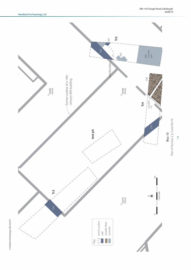
Trenches 3, 4, 5 and Test pit (Illus 10)6.2
These trenches were located to the south of Trenches
1 and 2 on the site of a recently demolished building.
Trenches 3 and 4 were deemed too deep to enter safely
and were only inspected from the present ground level.
Trench 3 contained a concrete wall at the northern end.
This was 1m wide and 2m deep and oriented north-east
to south-west. The trench was excavated to a depth of
2.8m. The upper deposit was 1.3m deep and consisted of
demolition rubble and mortar [030]. Beneath this was a
mixed sandy clay and stone deposit up to a metre deep
[031]. Beneath this at a depth of c. 2.6m below the present
ground surface was gravel and rounded stone deposit [032]
which sealed sandy blue-grey clay [033] with large clasts
of several decimetres in size that were observed to be
sub-rounded to angular. It was initially thought that this
Illus 9Wall [021], [022] and fl oor [024]
396–410 Gorgie Road, EdinburghGGRE10
7
Headland Archaeology LtdHeadland Archaeology Ltd
© H
eadl
and
Arc
haeo
logy
(UK)
Ltd
201
1
04
3co
ncr
ete
pa
d
ove
rbu
rde
n
03
8
03
9
03
4
po
ssib
lecu
t
Ke
y
tre
nch
ou
tlin
e
wa
ll
wo
od
en
flo
or
con
cre
te
Tr3
Tr4
Tr5
test
pit
04
1
04
4
04
232
2475
6721
25
3224
9067
2135
3224
9067
2125
form
er
ou
tlin
e o
f a
19
th
cen
tury
Mill
bu
ildin
g
05m
1:12
5 @
A4
N
Illus
10
Pla
n o
f Tre
nch
es 3
, 4, 5
an
d T
est
Pit

8
deposit might be fi ll within a former mill lade and it was
examined by a palaeo-environmental archaeologist (Scott
Timpany); the results of this analysis is given below.
A sample of the clay was taken for assessment from a
test pit and was found to contain a sparse quantity of
waterlogged plant remains together with frequent gravels
(many sub-angular to angular) and some fossil material.
The plant remains recovered were Juncus sp. (rush sp.)
fruits, a possible cotton grass (Eriophorum sp.) spindle,
moss indet. leaf and a vernal sandwort (Minutia verna)
seed. This plant assemblage indicates wet stony ground
was present and together with the gravels, which indicate
frost-shatter rather than water erosion, would suggest
this deposit is more likely to be of Late Glacial/Early
Holocene date rather than relating to a mill lade deposit.
Trench 4 and the test pit mentioned above contained the
same sequence of rubble and made ground as Trench 3.
A north-west to south- east oriented concrete wall of
identical construction to the wall in Trench 3 was present
at the west end of Trench 4. At the base of Trench 4, 2.3m
below present ground surface were two rectangular areas
of wooden planking with a narrow division between them
(Illus 11). These had been set into the sandy blue-grey
clay encountered at the base of Trenches 3 and the test
pit. The planks were 0.15m wide and 0.05m thick. They
were held in place by square section iron nails. It was
not possible to investigate these features further for safety
reasons. The structure formed by these planks respected
the line of the wall present at the north end of Trench 5
[044] and it is likely that they are contemporary.
Trench 5 contained a south-west to north-east oriented
concrete wall similar to those in Trench 3 and 4. A
narrow sandstone wall [041] that ran
perpendicular to the concrete wall was
present at a lower level (c 1.3m below
the present ground surface). A cement
slab fl oor was associated with this wall.
The presence of a large concrete pad in
the southern half of Trench 5 impeded
excavation and glacial deposits were not
reached.
Finds6.3
The fi nds amounted to a small assemblage
of pottery, glass and structural remains.
They were all modern, probably of
19th and 20th century date, though
some individual sherds may be a little
earlier. Glass fi nds included a number of
cylindrical hand fi nished wine bottles, of
late 18th or early 19th century date. The
pottery included various types of table
and storage wares, including a piece of
decorated Chinese porcelain and transfer
printed wares. The fi nds from rubble deposit [017] included
a piece of stained glass window, probably from a decorative
window light and pieces of decorative hearth tile. Both
are common types of fi tting in late 19th and early 20th
century Edinburgh tenements. The nail from deposit
[038] was found in a block of water logged wood. It is
not closely datable, but appears to be hand-wrought rather
than machine made and thus is likely to predate the 20th
century. The fi nds assemblage, while containing domestic
items, is not a secure indicator of the building’s function
as this type of material is commonplace in made ground
in areas close to settlement. It is possible that it represents
refuse from the workers in an industrial building.
DISCUSSION7.
The series of walls and fl oors encountered in Trenches
1 and 2 represent the remains of a building present on
the 1855 Ordnance Survey 1st Edition map within a
complex of buildings known as ‘Gorgie Mills’ (Illus 12).
The artefactual assemblage contains nothing inconsistent
with a 19th century date for this structure.
This cartographic evidence suggests an industrial rather
than domestic function for this building, but it could
conceivably have been a residence in the complex. The
building lies on the former location of Gorgie House
as marked on the Ordnance Survey maps from 1905.
There was no artefactual evidence to suggest a medieval
or indeed early post-medieval origin for the building,
despite the survival of contemporary fl oor surfaces.
There was also no evidence for any such activity through
the presence of residual artefacts in former topsoil that
survived beneath the building.
Illus 11Wooden planks at base of Trench 4

9
396–410 Gorgie Road, EdinburghGGRE10Headland Archaeology LtdHeadland Archaeology Ltd
© H
eadl
and
Arc
haeo
logy
(UK)
Ltd
201
1
It is possible that some discrepancy has occurred marking
the location of Gorgie House as the record made by the
RCHAMS (NMRS NT27 SW 8) would put it in the
area covered by Trenches 1 and 2. The few descriptions
that survive of Gorgie House suggest it was an ‘L’ shaped
building, which was added to in the 18th century; creating
an oblong structure, with a new eastern frontage added
in the 19th century (Smith 1928: 279). This description
seems a better fi t with the ground plan of buildings
present on the 1855 Ordnance Survey 1st Edition map to
the north-east of the development area (Illus 12) and this
is perhaps an equally likely location for Gorgie House.
The walls encountered in Trenches 3, 4 and 5 belonged to
the recently demolished 19th century mill. The wooden
structure, formed by a series of planks, respects the line
of these walls and is likely to be contemporary with
this building. The handmade nature of the nails suggest
an early 19th century date for the structure indicating
they may be associated with the building’s fi rst use. The
evaluation uncovered no evidence of an earlier phase of
mill.
REFERENCES8.
Bibliography8.1 Smith, J 1928 ‘Notes on the Lands and Manor House of
Gorgie, Edinburgh’, Proc Soc Antiq Scot, 62, 1927–8,
277–80.
Cartographic sources8.2 1855 Ordnance Survey Edinburghshire, 6” to 1 mile, sheet
6, 1855.
1905 Ordnance Survey Edinburghshire, 1:2500 scale map,
sheet III.10, 1905
National Monuments Record of Scotland8.3 NT27SW 8 Gorgie House
building located
in Tr1 & 2
likely location of
Gorgie House
Illus 121855 OS 1st Edition showing building in Trenches 1 and 2

10
APPENDICES
Appendix 1 – Site registers
Context register
Context no. Area Description
001 TR1 Black, coal and mortar-rich levelling deposit to the
north of wall 002
002 TR1 E-W oriented wall. Stone and lime-mortar with
lime mortar render
003 TR1 Foundation cut for wall 002
004 TR1 Fill of foundation cut 003
005 TR1 Compact silty clay-possible graden soil
006 TR1 Construction cut for culvert 008
007 TR1 Fill of construction cut 006
008 TR1 Stone and lime-mortared stone-capped culvert
009 TR1 E-W oriented wall. Stone and lime-mortared
010 TR1 Compact silty clay containing demolition rubble
and morar
011 TR1 Stone and lime-mortared stone-capped culvert
012 TR1 Brick-built wall
013 TR1 Flagstone fl oor
014 TR1 Possible step. Stone built over brick
015 TR1 E-W oriented wall. Stone and lime-mortared
widens to the east.
016 TR1 Bedding sand for fl agstone fl oor 013
017 TR1 Rubble and mortar levelling deposit
018 TR2 Wall, stone-built and lime mortared. Forms corner
of building.
019 TR2 Remains of a fl agstone fl oor associated with wall
018
020 TR2 Bedding sand for fl agstone fl oor 019
021 TR2 NW-SE oriented lime-mortared stone wall
022 TR2 SW-NE oriented lime-mortared stone wall
023 TR2 Flagstone fl oor associated with wall 021
024 TR2 Flagstone fl oor associated with wall 022
025 TR2 Bedding sand for fl agstone fl oor 023
026 TR1 Grey-brown sandy silt lower fi ll of culvert 008
027 TR1 Dark grey sandy silt upper fi ll of culvert 008
028 TR1 Grey-brown sandy silt fi ll of culvert 011
029 TR3 Modern rubble levelling deposit
030 TR3 Rubble and mortar levelling deposit
Context no. Area Description
031 TR3 Made ground- mixed sandy clay and rubble
leveling
032 TR3 Gravel and rounded stone deposit
033 TR3 Grey sandy clay
034 TR3 E-W oriented concrete wall
035 TR4 Modern rubble levelling deposit
036 TR4 Made ground- mixed sandy clay and rubble
leveling
037 TR4 Grey-blue sandy clay
038 TR4 Wooden plank structure at the base of Trench 4
039 TR4 E-W oriented concrete wall
040 TR5 Modern rubble levelling deposit
041 TR5 N-S oriented stone wall
042 TR5 Cement fl ags associated with wall 041
043 TR5 Concrete pad/fl oor
Photographic register
Photo
no.
Facing Description
001 – ID shot
002 SE Trench 3- view of the north end of trench showing
made ground
003 SW Trench 3- view of the north end of trench showing
made ground and concrete wall
004 N Trench 3- view of the north end of trench showing
made ground
005 E Trench 3-section
006 SE Trench 4 showing concrete wall
007 S Trench 4- wooden planks at the base of the trench
008 NE Trench 5- concrete pad (foreground) and wall
009 S Trench 5 showing made ground
010 SW Trench 5- concrete wall and fl oor (foreground)
011 N Trench 5- section
012 NE Trench 2- view of wall 018
013 E Trench 2- view of wall 018
014 S Trench 2- view of wall 018 and fl oor 019
015 SE Trench 2- view of wall 018 and fl oor 019
016 NW Trench 2- view of wall 021 and 022
017 NW Trench 2- view of wall 022 and fl oor 024
018 SE Trench 2- view of wall 021 and 022

11
396–410 Gorgie Road, EdinburghGGRE10Headland Archaeology LtdHeadland Archaeology Ltd
© H
eadl
and
Arc
haeo
logy
(UK)
Ltd
201
1
Photo
no.
Facing Description
019 S Trench 2- view of fl oor 023 and wall 021 and 022
020 SW Trench 2- detail of fl oor 023
021 S Trench 2- general view of walls 021, 022 and fl oor
023
022 SE Trench 1- view of culvert 008 and cut 006
023 NW Trench 1- view of culvert 008
024 SE Trench 1- view of wall 002
025 NW Trench 1- view of wall 002 showing lime render and
return
026 N Trench 1- south facing section of wall 009
027 E Trench 1- view of culvert 011
028 E Trench 1- view of brick and stone corner structure
012
029 SE Trench 1- view of fl agstone fl oor 013
030 E Trench 1- view of step 014
031 N Trench 1- view of wall 015 and bedding sand 016
032 E Trench 1- section showing demolition rubble 017
033 W Trench 1- view of wall continuing from 013
034 W Trench 1- section through culvert 008 showing fi lls
026 and 027
035 NE Trench 1- post excavation view of culvert 011
036 N Trench 1- general view
037 NW Trench 2- general view of walls 021, 022 and fl oor
023
038 SE Trench 2- general view of wall 018
039 S Trench 1- general view
040 SE Trench 1- general view
041 SE Trench 1- general view of fl oor 013 and brick and
stone structure 015
042 SE General view of area containing Trenches 1 and 2

12
Appendix 2 – Finds catalogue
Context no. Material Qty Object Description Spot Date Period
10 Glass 4 Bottle green sherds, including case bottle body sherd 18th/19th? Mod
17 CBM 3 Wall Tiles wall and/or hearth tiles, transfer printed blue design, moulded yellow, plain dark
red
m.19th-e.20th Mod
17 Glass 13 Bottle various base and neck sherds from cylindrical bottles, also natural sherd with
embossed lettering
e-L.19th Mod
17 Lead & Glass 1 Window fragment of stained glass window, appears to be rectangular border design,
some red and pale yellow fi elds remaining
Mod
17 Pottery (Mod) 8 Various stoneware, ironstone, porcelain, black trans printed, one hand coloured m.19th-m.20th Mod
27 Glass 3 Bottle green sherds, cylindrical bottles, one hand fi nished base sherd L.18th/e.19th Mod
27 Pottery (Mod) 1 Whiteware blue glazed L.18th-20th Mod
28 Glass 2 Bottle green sherds 18th-20th Mod
28 Pottery (Mod) 1 Various ?Chinese porcelain saucer, hand painted in blue 18th? Mod
36 CBM 1 Brick frogged brick, with stamped mark, partially obscured by mortar L.19th/20th Mod
38 Iron 1 Nail nail found in situ in block of waterlogged wood, square sectioned shaft, small
?square head

13
396–410 Gorgie Road, EdinburghGGRE10Headland Archaeology LtdHeadland Archaeology Ltd
© H
eadl
and
Arc
haeo
logy
(UK)
Ltd
201
1
Appendix 3 – Discovery and Excavation in Scotland
LOCAL AUTHORITY: City of Edinburgh Council
PROJECT TITLE/SITE NAME: 396–410 Gorgie Road, Edinburgh
PROJECT CODE: GGRE10
PARISH: Edinburgh
NAME OF CONTRIBUTOR(S): Ross Murray
NAME OF ORGANISATION: Headland Archaeology Ltd
TYPE(S) OF PROJECT: Evaluation
NMRS NO(S): NT27SW 8
SITE/MONUMENT TYPE(S): 19th century industrial/residential buildings
SIGNIFICANT FINDS: None
NGR NT 2248 7214
START DATE (this season) 1st November 2011
END DATE (this season) 4th November 2011
PREVIOUS WORK (incl. DES ref.) –
MAIN (NARRATIVE) DESCRIPTION:
(May include information from other fi elds)
An archaeological evaluation was undertaken at 396 Gorgie Road, Edinburgh in order to support an
application for planning consent in advance of development for student accommodation. A total of fi ve
trenches were excavated, two of which were placed on the supposed site of Gorgie House. This was dated to
the 17th century by the RCHAMS during a site visit prior to its demolition in 1937. These trenches contained
the remains of a square building present on the 1855 Ordnance Survey 1st Edition map that is likely to be
associated with the 19th century industrial buildings to the south and west. No trace of a medieval or early
post-medieval structure was located and it is possible that Gorgie House was sited to the north-east, outwith
the proposed development area.
The remaining trenches uncovered the remains of a recently demolished early 19th Century building and an
associated wooden structure.
PROPOSED FUTURE WORK: Yes
ARCHIVE LOCATION (intended/deposited) Archive to be deposited at RCAHMS.
Reports to be deposited at RCAHMS and CECAS.
SPONSOR OR FUNDING BODY: Chamic Developments Ltd
CAPTION(S) FOR ILLUSTRS: –
ADDRESS OF MAIN CONTRIBUTOR: Headland Archaeology Ltd, 13 Jane St, Edinburgh. EH6 5HE
EMAIL ADDRESS: [email protected]


Headland Archaeology (UK) Ltd
© Headland Archaeology (UK) Ltd 2011
North East
13 Jane Street, Edinburgh EH6 5HET 0131 467 7705 F 0131 467 7706 E offi [email protected]
South & East
Technology Centre, Stanbridge Road, Leighton Buzzard, Bedfordshire LU7 4QHT 01525 850 878 E [email protected]
www.headlandarchaeology.com
Midlands & West
Unit 1, Premier Business Park, Faraday Road, Hereford HR4 9NZT 0143 236 4901 F 0143 236 4900 E [email protected]
North West
10 Payne Street, Glasgow G4 0LFT 0141 354 8100 F 0141 332 9388 E glasgowoffi [email protected]


![396 - [Irmãs Royle 01] - Como Seduzir Um Duque (CH 396)](https://img.pdfslide.net/doc/110x75/55cf97cf550346d03393c201/396-irmas-royle-01-como-seduzir-um-duque-ch-396.jpg)