Embed Size (px)
Citation preview
Meridian Consultants 4.1-1 Inglewood Transit Connector Project 208-001-18 November 2021
4.1 AESTHETICS
4.1.1 INTRODUCTION
This section of the Recirculated Draft Environmental Impact Report (Recirculated Draft EIR) evaluates the
impacts of the proposed Inglewood Transit Connector Project (proposed Project or ITC Project) on
aesthetics and visual character, obstruction of views, nighttime illumination, light and glare, and shading.
The evaluation of aesthetics and visual character impacts considers the existing visual character of the
area along the proposed alignment, and how implementation of the proposed Project would affect this
visual character. The evaluation of view impacts considers existing viewsheds and visual resources that
may be affected by the development of the Project alignment. The analysis of light and glare assesses the
effects of new sources of nighttime lighting and glare from the reflection of sunlight or artificial light from
any reflective surface that would be created by the Project. This section also evaluates patterns of shading
that would be created by the proposed Project and the effect on uses along the proposed alignment.
Prior to the preparation of the December 2020 Draft EIR, a Recirculated Initial Study was prepared using
the California Environmental Quality Act (CEQA) Environmental Checklist Form to assess potential
environmental impacts associated with aesthetics. For two of these screening thresholds, the Initial Study
found that the proposed Project would result in a “Less than Significant Impact,” and thus, no further
analysis of these topics in an EIR was required. The following Initial Study screening criteria related to
aesthetics do not require any additional analysis in this Recirculated Draft EIR:
• Impacts related to a substantial adverse effect on a scenic vista were evaluated and determined to be “Less than Significant” in the Initial Study. As discussed therein, the City of Inglewood (City)’s General Plan does not designate any scenic vistas within the City or its vicinity. Additionally, no views of regional mountain ranges, focal points, or broad panoramic view corridors are available from public rights-of-way along the proposed alignment. Therefore, impacts on scenic vistas from the proposed Project would be less than significant.
• Impacts related to substantial damage to scenic resources, including, but not limited to, trees, rock outcroppings, and historic buildings within a State scenic highway were evaluated and determined to be “Less than Significant” in the Initial Study. As discussed therein, the Project alignment is not located in the vicinity of a designated scenic highway. Thus, no trees or historic resources on the Project alignment are located within a State scenic highway. Additionally, no rock outcroppings are present on or near the Project alignment. Therefore, impacts on scenic resources within a State scenic highway from the proposed Project would be less than significant.
After circulation of the December 2020 Draft EIR for public review, the City revised the design of the Project
in response to consultation with key stakeholders in the community and comments received on the
December 2020 Draft EIR. Changes to the Project relevant to the potential effects on the aesthetic and
Meridian Consultants 4.1-2 Inglewood Transit Connector Project 208-001-18 November 2021
visual character of the area include defining Project design features that address the visual characteristics
of the Project as described below in Section 4.1.7.1: Project Design Features. Specific changes to the
Project related to potential effects on the visual and aesthetic character of the areas surrounding the
proposed alignment include raising the height of the ATS guideway along Market Street to preserve
existing views of historic buildings, relocating the Prairie Avenue/Pincay Drive Station to the southwest
corner of Prairie Avenue and Manchester Boulevard to avoid impacts on Kelso School, redesign of the
proposed MSF to allow this facility to be located on the proposed site with a new Vons store, and
realignment of the guideway and stations on Prairie Avenue to the west side of Prairie Avenue.
The changes to the design of the Project do not create the potential for significant impacts related to
scenic vistas or scenic resources as described above. There are no designated scenic vistas within the City
or its vicinity nor would the revised Project be located within a State scenic highway.
Impacts found to be less than significant are further discussed in Section 6.0: Other Environmental
Considerations.
Please see Section 8.0 for a glossary of terms, definitions, and acronyms used in this Draft EIR.
4.1.2 OVERVIEW
4.1.2.1 Aesthetic Resources
Aesthetic resources include a range of visual elements, including landforms, vegetation, water features,
the urban design characteristics of an area, and the architecture present in an area that define how an
observer experiences a place through sensory interaction. Factors considered include visual character,
scenic resources, and scenic vistas. These factors, which describe the aesthetic character of a particular
area are described further below.
Visual Character
Visual character describes the unique combination of aesthetic resources, scenic elements, and landscape
characteristics that contribute to the identity of a particular place. These components provide for the
visual sensory interaction with a particular place by users who experience it. This interaction constitutes
the basis of the overall impression a place has upon the observer. In urban settings, these characteristics
largely include land use type and density, urban landscaping and design, architecture, topography, and
background setting.
Meridian Consultants 4.1-3 Inglewood Transit Connector Project 208-001-18 November 2021
Scenic Resources
Scenic resources typically include natural open spaces, topographic formations, and landscapes that
contribute to a high level of visual quality. They also include ridgelines, parks, trails, nature preserves,
sculpture gardens, the built environment, and similar features that are critical in shaping the visual
character and scenic identity of a given area and surrounding region.
Scenic Vistas
Scenic vistas are generally described in two ways: panoramic views which is visual access to a large
geographic area, for which the field of view can be wide and extend into the distance; and focal views
providing visual access to a particular object, scene, or feature of interest. In general, scenic vistas are the
range by which scenic resources may be observed. This definition combines visual quality with information
about view exposure to describe the level of interest or concern that viewers may have for the quality of
a particular view or visual setting.
4.1.3 METHODOLOGY
4.1.3.1 Visual Character
Impacts on visual character were determined by comparing existing visual conditions at and around the
proposed Project area alignment with the change in these conditions that would result from
implementation of the proposed Project. The study area for the aesthetics analysis comprises the Project
alignment and adjacent areas. The Project area includes the Automated Transit System (ATS) components,
including the guideway, stations, and support facility sites (maintenance and storage facility [MSF]
including the Vons supermarket, and power distribution system [PDS] substations ), and properties
adjacent to the ATS and proposed components.
The methodology used to assess visual character impacts considers how the proposed Project would affect
views of the area. This assessment focuses on views of the proposed Project along major roadways and
on other public viewpoints where visual change would occur with implementation of the proposed
Project. Public viewpoints of the Project area available to the general public traveling to or near the Project
are located along Market Street, Manchester Boulevard, and Prairie Avenue.
Establishing the basis for the analysis also involved collecting and reviewing existing plans and guidelines
in effect within or adjacent to the Project area that address design, architecture, and landscaping. These
plans include the Hollywood Park Specific Plan1 (HPSP) and the New Downtown and Fairview Heights
1 City of Inglewood, Hollywood Park Specific Plan, adopted July 8, 2009, amended September 23, 2014, and further amended
February 24, 2015.
Meridian Consultants 4.1-4 Inglewood Transit Connector Project 208-001-18 November 2021
Transit-Oriented Development Plan and Design Guidelines (Downtown TOD).2 These plans define the
standards for development within these areas.
4.1.3.2 Light and Glare
Light and glare also influences the visual character of an area. The provision of adequate and appropriate
lighting and limiting glare and the potential for glare are fundamental safety requirements in the design
of any large facility or structure. The analysis focuses on light spillover effects, which involve light that
shines beyond the area intended for illumination that can be a source of annoyance to adjoining
properties, particularly for residences where light (e.g., direct illumination) might disturb sleep or privacy.
Glare—both daytime reflection of sunlight off large expanses of reflective surface (cars, buildings, or
structures) and unshielded nighttime lighting (outdoor or indoor)—can also have adverse effects.
Accordingly, this section also addresses the potential for the proposed Project to: (1) introduce new light
sources that could adversely affect nearby light-sensitive receptors (e.g., residential uses, hotels, and
natural areas); and (2) introduce new light or glare sources that could adversely affect day or nighttime
views in this area.
4.1.4 REGULATORY FRAMEWORK
4.1.4.1 State Regulations and Directives
California Department of Transportation (Caltrans) Scenic Highway Program
The Caltrans Scenic Highway Program3 protects and enhances the natural scenic beauty of California’s
highways and corridors through special conservation treatment. Caltrans defines a scenic highway as any
freeway, highway, road, or other public right-of-way that transverses an area of exceptional scenic quality.
Caltrans designates a scenic highway by evaluating how much of the natural landscape a traveler sees and
the extent to which visual intrusions degrade the scenic corridor. No officially designated scenic highways
are located within the City.
4.1.4.2 Local Regulations and Directives
City General Plan
The City General Plan including the Land Use Element,4 was adopted in August 1968 and was amended in
1980, with additional amendments, including the latest amendment in 2020. Goals, objectives, and
2 City of Inglewood, New Downtown and Fairview Heights Transit Oriented Development Plan and Design Guidelines,
November 1, 2016. 3 Caltrans, Scenic Highways, https://dot.ca.gov/programs/design/lap-landscape-architecture-and-community-livability/lap-
liv-i-scenic-highways, accessed July 30, 2020. 4 City of Inglewood General Plan, “Land Use Element” (adopted 1980, last amended 2020),
https://www.cityofinglewood.org/DocumentCenter/View/132/Land-Use-Element-1980-Amended-1986-2009-2016-PDF,.
Meridian Consultants 4.1-5 Inglewood Transit Connector Project 208-001-18 November 2021
policies of the City’s General Plan Land Use Element applicable to this aesthetics section of the Draft EIR
are outlined as follows:
Land Use Element
The Land Use Element sets forth Citywide policies for the general location and intensity of land uses, and
includes the following goals and policies that are relevant to the proposed Project in this section:
Downtown Transit Oriented District Goals and Policies (as amended September 2016)
Goal 1: Downtown is a place to live, work, shop, recreate, and be entertained.
Policy 1.1: Mixed Use Development. Encourage a range of residential, retail, office, recreational, and institutional uses in the Historic Downtown to create a vibrant urban district and support local business.
Policy 1.2: Ground Floor Uses and Storefronts. Require uses that activate
pedestrian activity such as retail on major streets and plaza
frontages. Require that storefronts be historically-sensitive,
attractive, and transparent in the Historic Downtown.
Goal 2: Downtown is a revitalized yet forward-looking gathering place for the community.
Policy 2.1: Public Gathering Places. Create public spaces in key locations in
the public right-of-way and on privately-owned land. In particular,
create a central plaza along Market Street between Florence
Avenue and Regent Street and/or in the adjacent parcels suitable
for eating, resting and people watching, but also for festivals,
concerts, and events at special times.
Policy 2.3: Preservation of Historic Fabric. Require the preservation of
buildings that have been designated as historic and encourage
the reuse of other historic buildings. Maintain the sense of place
in areas with historic fabric and/or meaning such as Market Street
between Regent Street and Hillcrest Avenue and the Hillcrest
neighborhood east of Locust Street.
Goal 6: Downtown expresses the unique culture of Inglewood.
Policy 6.1: Districts. Define the following unique districts within the
Downtown TOD area, each with their own unifying character or
Meridian Consultants 4.1-6 Inglewood Transit Connector Project 208-001-18 November 2021
identity that should be preserved and enhanced: Historic
Downtown, Civic Center, TechTown, Beach Avenue, Fairview
West, Hillcrest and Queen Street.
Policy 6.2: Performing Arts. Build on assets such as the Fox Theater, Forum
and Hollywood Park to establish Downtown Inglewood as part of
an Inglewood entertainment and performing arts hub serving
both the City and the region.
Policy 6.3: Visual Arts. Commission public art to provide an attractive
environment for residents, employees, and visitors. Take steps to
ensure a continuing role for the Inglewood art community in
Downtown’s visual and performing arts.
Goals and Objectives (as adopted January 1980)
• Promote Inglewood’s image and identity as an independent community within the Los Angeles metropolitan area.
• Improve the visual appearance and economic condition of the existing arterial commercial development along Inglewood’s major streets.
Open Space Element
The Open Space Element5 sets forth Citywide policies for current and future recreation needs of the
community for park land and recreation facilities. It is also a plan for the conservation or creation of open
spaces to mitigate the effects of increasing urbanization of Inglewood. Since Inglewood lacks any natural
resource such as a lakeshore or riverbank, the Element focuses on two basic types of open space: the
traditional city park and the nonpark open space, including public plazas, landscaped boulevards, and
greenbelts between buildings on private property. The following policy is relevant to the proposed Project
in this section:
Policy 1: The City of Inglewood and its redevelopment agency, in reviewing and approving
development plans, shall require the provision of landscaped plazas and gardens
when possible, and the provision of landscaping within building setbacks and
parking lots.
5 City of Inglewood General Plan, “Open Space Element” (adopted 1973, last amended 1995),
https://www.cityofinglewood.org/DocumentCenter/View/132/Land-Use-Element-1980-Amended-1986-2009-2016-PDF.
Meridian Consultants 4.1-7 Inglewood Transit Connector Project 208-001-18 November 2021
New Downtown and Fairview Heights Transit-Oriented Development Plan and Design Guidelines
The New Downtown and Fairview Heights Transit Oriented Development Plan and Design Guidelines6
(Downtown TOD Plan) covers the Downtown Inglewood and Fairview Heights neighborhoods of the City
and works to implement the City’s vision for transforming the quality of the environment within these
areas. The Downtown TOD Plan area consists of approximately 585 acres located in the center of
Inglewood along the new Metro K line just east of the Florence Avenue/La Brea Avenue intersection. This
TOD Plan area extends approximately one-half mile in all directions from the Metro K line Downtown
Inglewood Station (Downtown Inglewood Station). The Downtown TOD Plan planning and zoning area also
extends approximately one-half mile in all directions from the Downtown Inglewood Station.
The Downtown TOD Plan includes concept plans, zoning, development standards and design guidelines,
and an implementation action plan for consideration by applicants submitting any proposals for new
construction or rehabilitation within the Plan area, as well as for consultation by City Staff when making
recommendations for project approvals. The Downtown TOD Plan addresses architectural detail, signage,
public art, and civic and cultural life. Further, the Downtown TOD Plan includes street tree concepts,
including recommended street tree locations and species along roadways within the Downtown and
Fairview Heights neighborhoods.
Section 2.8: Street Trees and Furniture7 of the Downtown TOD Plan establishes that street trees are
important elements of streetscapes and placemaking and provides guidelines on the character of trees
placed within key areas of Downtown Inglewood. The Downtown TOD Plan recommends that Manchester
Boulevard be lined with London Plane (Platanus × acerifolia) trees, or a similar species. This tree’s ability
to withstand air pollution, drought, as well as most diseases makes it a desirable street tree that would
also provide some uniformity and connectivity for Downtown Inglewood. In the case of Florence Avenue,
the Downtown TOD Plan calls for London Plane trees alternated with the California fan palm
(Washingtonia filifera). Market Street should retain its existing street trees. The smaller arterial streets
near Market Street may alternate between the Brisbane box (Lophostemon confertus), an evergreen tree,
and the ginkgo (Ginkgo biloba), a deciduous tree. The Downtown TOD Plan states that these smaller street
trees bring down the scale of the streets and create a sense of place throughout the streets of Downtown
Inglewood.
6 City of Inglewood, New Downtown and Fairview Heights Transit Oriented Development Plan and Design Guidelines,
November 1, 2016. 7 City of Inglewood, New Downtown and Fairview Heights Transit Oriented Development Plan and Design Guidelines,
November 1, 2016, Section 2.8: Street Trees and Furniture, p. 19.
Meridian Consultants 4.1-8 Inglewood Transit Connector Project 208-001-18 November 2021
Hollywood Park Specific Plan
The HPSP8 establishes development standards and design guidelines for the 238-acre Hollywood Park site
at the northeast corner of the Prairie Avenue and Century Boulevard intersection and provides an
overview of existing infrastructure and necessary improvements related to the site, including measures
for implementation measures of the plan. The site is currently under development and with SoFi Stadium
constructed and operating and ongoing development of a 6,000-seat entertainment venue, parks, and
retail, office, housing, entertainment, gaming, hotel, and civic uses.
The HPSP includes guidelines and standards for improvements in the public right-of-way within the plan
area, which includes approximately 0.5 miles of street frontage along South Prairie Avenue. The HPSP also
provides integrated and coordinated landscape design guidelines for new development along the
perimeter of the Plan area with the objective of promoting land use compatibility, particularly along South
Prairie Avenue.
The HPSP includes streetscape standards and provides integrated and coordinated landscape design
guidelines for new development along the perimeter of the HPSP area to integrate it with the adjoining
urban fabric, achieve a diverse urban forest, and assist in developing districts of distinctive and appropriate
character.9 Sidewalk widths are intended to provide walking routes and parkway widths are designed to
provide sufficient area for urban tree growth. The HPSP guidelines and standard for streetscape include
identity elements that would differentiate Hollywood Park from nearby developments through
architectural features, landscaping (such as seasonal displays of color), graphic elements (such as signs or
logos), special pedestrian or automobile paving, special night lighting effects, or other similar features.
The HPSP, Section 3.2.2: Streetscape, identifies selected street trees and the desired locations for their
placement on internal roadways within the HPSP area as well as along major adjacent roadways, including
Prairie Avenue, Century Boulevard, and the intersection corner of those roadways.10 A majority of the tree
species listed in the HPSP were selected from the City’s approved tree list.11 Selections were based upon
recommendations from local arborists to create a palette of horticulturally successful, low maintenance,
and climate-appropriate tree species. Alternative selections can be proposed, subject to City approval.
8 City of Inglewood, Hollywood Park Specific Plan, adopted July 8, 2009, amended September 23, 2014, and further amended
February 24, 2015. https://www.cityofinglewood.org/DocumentCenter/View/1347/Hollywood-Park-Specific-Plan. 9 City of Inglewood, Hollywood Park Specific Plan, adopted July 8, 2009, amended September 23, 2014, and further amended
February 24, 2015., Section 3.2.2, Streetscape, p. 3-28. 10 City of Inglewood, Hollywood Park Specific Plan, adopted July 8, 2009, amended September 23, 2014, and further amended
February 24, 2015., Section 3.2.2, Streetscape, Exhibit 3-25—Landscape Street Sections Map, p. 3-28. 11 City of Inglewood, Hollywood Park Specific Plan, adopted July 8, 2009, amended September 23, 2014, and further amended
February 24, 2015., Section 3.2.2, Streetscape, Exhibit 3-25—Landscape Street Sections Map, p. 3-28.
Meridian Consultants 4.1-9 Inglewood Transit Connector Project 208-001-18 November 2021
The HPSP states that street trees along Prairie Avenue shall be substantial and continuous to achieve an
appropriate scale for the street.12 Along the portion of Prairie Avenue north of Hardy Street, large
columnar evergreen trees such as Afghan pine (Pinus eldarica) or Canary Island pine (Pinus canariensis)
would provide continuity with the retail development to the east and the cemetery to the north. This
arrangement is intended to visually reduce the scale of the street and provide ample shade as visitors
approach the HPSP site. Both Prairie Avenue south of Hardy Street and the northern side of Century
Boulevard would be similarly lined with large evergreen trees such as camphor trees (Cinnamomum
camphora) or Southern magnolia (Magnolia grandiflora). In addition, large canopy flowering trees and
palms would mark key points near the HPSP site, including the retail corner and major entries, and
maintain adequate street visibility. Selected species include Date palm (Phoenix dactylifera), Chanticleer
Callery pear (Pyrus calleryana), and pink trumpet tree (Tabebuia impetignosa). Palm trees at the
northeastern corner of Prairie Avenue and Century Boulevard are intended to provide a thematic
connection to Century Boulevard near the Los Angeles International Airport (LAX).
City Municipal Code
The City Planning and Zoning Code Chapter 12, Planning and Zoning identifies zoning districts and land use
classifications, land use regulations, development standards, and environmental standards. The Zoning
Ordinance is intended to protect and promote the public’s health, safety, and general welfare, and to
implement the policies of the comprehensive General Plan.
Lighting and Signage
Lighting and signage are also regulated by the Inglewood Municipal Code Chapter 12,13 which defines
minimum standards to safeguard life, health, property, and the public welfare by regulating and controlling
the design, quality of materials, construction, size, height, location, and maintenance of all signs, sign
structures, and other exterior advertising devices.
Tree Preservation
The Municipal Code Tree Preservation14 recognizes the importance of both native and nonnative trees within the City. Properly maintained trees increase property values, maintain the natural ecology, temper the effects of extreme temperatures, reduce runoff, prevent erosion of topsoil, and help create and maintain the identity and visual character of the City. Prior to removing or cutting a protected tree in the City, a permit must be approved by the City’s Parks, Recreation, and Library Services Department.
12 City of Inglewood, Hollywood Park Specific Plan, adopted July 8, 2009, amended September 23, 2014, and further amended
February 24, 2015., Section 3.2.2, Streetscape, p. 3-29. 13 Inglewood, California, Municipal Code, Chapter 12, Article 23, Sign Regulation. 14 Inglewood, California, Municipal Code, Article 32, Section 12-110 (2012), Tree Preservation.
Meridian Consultants 4.1-10 Inglewood Transit Connector Project 208-001-18 November 2021
City Design and Development Standards/Design Review Process
The City’s Design and Development Standards,15 supplements the Municipal Code with design standards
and guidelines for development. The City has established a design review process and design standards to
accomplish the following:
• To maximize freedom, creativity, and innovation in the architecture, landscape design and graphics of each individual project within the framework of constraints imposed by the community’s need to control development for the health, safety, and general welfare of its citizens.
• To promote a visually attractive, safe, and well-planned community through the use of sound design techniques.
• To protect citizens from unsafe or unsightly conditions.
• To minimize potential nuisances to the uses surrounding the new development.
• To preserve and maximize the image, character, and visual quality which is making Inglewood an attractive place to live and work.
Additionally, The Municipal Code outlines the design review process required for development in the “D”
Supplemental Design Review Zone.16 This supplemental designation includes the TOD Mixed Use 1, TOD
Mixed Use 2, and Historic Core zones.
4.1.5 EXISTING CONDITIONS
4.1.5.1 Aesthetics and Views
City of Inglewood
The proposed Project is located entirely within the City, approximately 5.5 miles east of the Pacific Ocean,
within a broad coastal plain surrounded by rising land to the south and north, and more-level terrain
extending east. The City is a highly developed urban area containing moderately dense development along
major corridors that consist of commercial, residential, and industrial uses. The street corridors provide
the only long-range views available in the City, including limited views of Baldwin Hills to the north and
other urban areas in and surrounding the City. Overall, the views within and surrounding the City are
consistent with the views of a highly developed urban area.
No designated or otherwise identified scenic views or vistas are located within or visible from the City.17
The City’s General Plan states that no forest resources, wildlife, fisheries, shorelines, or agricultural land
are present in the City,18 nor does the General Plan designate any scenic vistas within the City or its vicinity.
15 City of Inglewood, Technical Background Report (2006), Design and Development Standards, adopted January 30, 1979. 16 City of Inglewood, Municipal Code Ch. 12, art. 14 (2010). 17 Google Earth, 2020. 18 City of Inglewood General Plan, “Conservation Element” (1997), 1.
Meridian Consultants 4.1-11 Inglewood Transit Connector Project 208-001-18 November 2021
Further, there are no designated or eligible State scenic highways within or adjacent to the Project area.19
The nearest State scenic highway is Interstate 110 between mile post 25.7 and 31.9, which is located north
of downtown Los Angeles and south of Interstate 210 in Pasadena. The closest portion of this scenic
highway is approximately ten miles northeast of the Project boundary.
Additionally, the Project area is not near any designated wild or scenic rivers pursuant to the National Wild
and Scenic Rivers System.20 The nearest mountains, the Santa Monica Mountains, are more than 10 miles
north of the Project boundary. No views of these mountains or of any other focal points or broad
panoramic view corridors are available from public rights-of-way along the proposed alignment.
Project Area
Market Street Segment
The Market Street Segment begins at the intersection of Market Street and Florence Avenue and
terminates at the intersection of Market Street and Manchester Boulevard. Aside from the shopping
center and the vacant lot immediately south of Florence Avenue, this section of Market Street is composed
primarily of low-rise commercial buildings and storefronts along a narrow two-lane roadway, with the
exception of the former Fox Theater building, which includes structural components rising above most other nearby structures. Pedestrian sidewalks are landscaped with planters and street trees and street
amenities such as benches, decorative streetlights, and decorative street posts. Landscaped medians
divide the slightly curving two-lane roadway to define an intimate setting and slow traffic, with metered
parking spots lining either side of the roadway to allow patrons to stop and shop at local businesses.
Manchester Boulevard Segment
The Manchester Boulevard Segment begins at the intersection with Market Street and ends at the intersection with Prairie Avenue. Low-rise commercial buildings are located on both sides of Manchester
Boulevard with storefronts making up the majority of the building facades along the roadway. Two parking
lots approximately a block in length line the street adjacent to Hillcrest Boulevard on either side of the
roadway, supporting two commercial shopping centers. Residential and church uses are also adjacent to
Manchester Boulevard in smaller numbers, appearing as low-rise buildings along the roadway.
This segment of Manchester Boulevard includes two travel lanes in each direction with a median turn lane throughout the entire segment. Occasional concrete medians with street signs divide the lanes going in
opposite directions and accommodate turn pockets. Metered parking spaces are located along the
19 California Department of Transportation, California Scenic Highway Mapping System, Los Angeles County,
http://www.dot.ca.gov/hq/LandArch/16_livability/scenic_highways/, accessed August 2018. 20 US Fish and Wildlife Service, National Wild and Scenic Rivers System, available at https://www.rivers.gov/, accessed August
31, 2018.
Meridian Consultants 4.1-12 Inglewood Transit Connector Project 208-001-18 November 2021
roadway. Sidewalks are provided on both sides of the street with palm trees, and streetlights on simple
gray. Street signs are attached to the poles of the streetlights to help direct traffic with arrows and speed
limits. Billboards containing large advertising displays are located on sides of the street. Limited landscaping is provided along this segment. Street benches and trash receptacles of simple design can be
found at the bus stops along this segment.
Prairie Avenue Segment
The Prairie Avenue Segment begins at the intersection with Manchester Boulevard and ends at the
intersection with Hardy Street. Low-rise commercial buildings, often with adjacent surface parking lots
occupy the majority of the area to the west of Prairie Avenue. Located between Nutwood Street and Kelso Street is the Kelso Elementary School with single story structures that are simple in design. The playground
and sports facility at the school is raised and located adjacent to Prairie Avenue. Single- and multifamily
residential buildings, one- to two-stories in height, are also located along this segment of Prairie Avenue.
The Forum is located on the east side of Prairie Avenue between Manchester Boulevard and Pincay Drive.
The Forum is a large circular building surrounded by an expansive surface parking lot, with vehicle
entrances along Prairie Avenue. South of Pincay Drive is SoFi Stadium and a mixed-use community under development in the HPSP area. SoFi Stadium, which opened in September 2020, is located southeast of
The Forum property and south of Pincay Drive. The SoFi stadium features a translucent roof which covers
the stadium proper, the adjacent pedestrian plaza, and the attached performance venue. The stadium
bowl contains open sides as part of its design. The majority of the HPSP site is currently under construction
and consists of vacant graded areas enclosed by windscreen fences. Temporary construction lighting is
visible throughout the site. Entrances to the construction site with security checkpoints are visible along
the west side of Prairie Avenue.
Prairie Avenue includes three travel lane lanes in each direction, with a turn lane at the center of the
roadway and additional right turn lanes in some locations Sidewalks are provided on both sides of Prairie
Avenue with limited landscaping and street trees. Traffic signs are affixed on gray traffic poles and gray
streetlight poles are located along the street. Multiple driveways are located along both sides of the street
to allow for vehicles to enter parking lots and construction sites. A stretch of landscaped median extends
from south of Arbor Vitae Street to just north of Hardy Street.
4.1.5.2 Light and Glare
The entire Project alignment is located in a highly urbanized area containing numerous light sources that
generate varying degrees of light. Nighttime lighting is necessary to provide and maintain safe, secure, and
attractive environments. However, these lights have the potential to produce spillover light and glare if
Meridian Consultants 4.1-13 Inglewood Transit Connector Project 208-001-18 November 2021
designed incorrectly. Light sources located close to light-sensitive receptors, such as residential units at
nighttime, are most relevant for this analysis.
As described below, existing light sources in the Project area are typical of a highly developed area containing commercial and residential uses. The Project area does not contain any sources of light or glare
that currently interfere with daytime or nighttime visibility. The existing levels of lighting are typical for a
mix of commercial and residential uses located in an urban area, and there are no existing sources of light
or glare that affect existing uses along these street segments.
Market Street Segment
Sources of existing ambient light along the Market Street Segment includes streetlights, vehicle headlights, traffic lights, and lighting from parking lots and commercial buildings. There are no existing light sensitive
uses located along this segment of Market Street, such as residential dwellings and hotels/motels.
The facades of buildings along Market Street primarily include non-reflective materials that do not create
glare. Existing nighttime sources of glare are primarily associated with vehicle headlights traveling
throughout the area.
Manchester Boulevard Segment
Sources of nighttime illumination on Manchester Boulevard consist of light sources commonly found in
developed urban areas, including streetlights, vehicle headlights, traffic lights, and lighting from adjacent
buildings. This segment includes residential homes on the north side of the street between Manchester
Drive and Osage Avenue which are currently exposed to these sources of light.
The facades of buildings along this segment primarily include non-reflective materials that do not
contribute to glare. Existing nighttime sources of glare are primarily associated with vehicle headlights
traveling on Manchester Boulevard and adjacent streets.
Prairie Avenue Segment
Nighttime lighting on Prairie Avenue consists of light sources commonly found in developed urban areas,
including streetlights, vehicle headlights, traffic lights, lighting from buildings located along the street and
lighting associated with billboards located along this segment of Prairie Avenue. Residential and motel
uses located west of Prairie Avenue are currently exposed to these light sources.
East of Prairie Avenue, nighttime lighting associated with the surface parking lots surrounding the Forum
and HPSP are also visible from the residential and motel uses west along Prairie Avenue. The parking lot
lights at the Forum and HPSP are similar in intensity to the adjacent streetlights. Although located

Meridian Consultants 4.1-14 Inglewood Transit Connector Project 208-001-18 November 2021
throughout the large surface parking lots and along the perimeter, these lights are shielded and directed
and result in limited light spillover onto these light-sensitive uses.
The facades of buildings along this segment primarily consist of non-reflective materials that do not contribute to glare conditions. Existing nighttime sources of glare are primarily associated with vehicle
headlights traveling on Prairie Boulevard and adjacent streets.
4.1.5.3 Adjusted Baseline Conditions
The Adjusted Baseline Environmental Setting as described in Section 4.0: Environmental Impact Analysis,
4.0-5: Adjusted Baseline is considered in this analysis. The residential, office, retail, and entertainment
uses associated with the Adjusted Baseline projects would result in changes to the visual conditions east
of Prairie Avenue within the HPSP area.
The Champion Park neighborhood planned between Arbor Vitae Street and Hardy Street west of Prairie
Avenue would accommodate a range of housing types with a residential gateway constructed at the
intersection of Arbor Vitae Street and Prairie Avenue. Street trees along this segment of Prairie Avenue
would be primarily Afghan Pine (Pinus eldarica) planted along the sidewalks and the roadway median.21
At the intersection of Hardy Street and Prairie Avenue a primary point to the HPSP community is planned as a gateway consisting of substantial structures and signage to introduce patrons to the retail and
entertainment located west of Prairie Avenue from Hardy Street to Century Boulevard. Street trees south
of Hardy Street would be Camphor (Cinnamomum camphora) trees. Street trees on the east side of Prairie
Avenue would be substantial in stature, ranging from 40 feet to 50 feet in height and create a buffer
between this area and Prairie Avenue.22
All exterior lighting at the HPSP would be directed onto the driveways, walkways, and parking areas and shielded to minimize glare and light spill onto adjacent properties and streets. In addition to lighting on
vertical structures, specialty lighting would be used to highlight architectural elements, landscaping, and
building tenant and project signage. Security and safety lighting would also be provided as necessary in
parking areas, service passages, and common areas. All lighting would be directed toward the ground
wherever feasible or screened to minimize illuminating surrounding areas and minimize glare and
interference with vehicular traffic. Additionally, building facades and windows would be constructed of non-reflective materials to avoid glare impacts on surrounding residential properties and streets. While
21 City of Inglewood. Hollywood Park Specific Plan. Adopted July 8, 2009. Amended September 2014 and February 2015. 22 City of Inglewood. Hollywood Park Specific Plan. Adopted July 8, 2009. Amended September 2014 and February 2015.
Meridian Consultants 4.1-15 Inglewood Transit Connector Project 208-001-18 November 2021
the new buildings and site improvements in the HPSP area would substantially change the visual
environment east of Prairie Avenue, these changes would not conflict with nearby uses.23
4.1.6 THRESHOLDS OF SIGNIFICANCE
Criteria outlined in CEQA Guidelines were used to determine the level of significance of aesthetics impacts.
The Project would have a significant impact in relation to aesthetics if it would result in the following
Threshold AES-1a Substantially degrade the existing visual character or quality of public views of
the site and its surroundings.
Threshold AES-1b Be inconsistent with applicable zoning and planning regulations governing
scenic quality.
Threshold AES-2 Create a new source of substantial light or glare, which would adversely affect
day or nighttime views in the area.
4.1.7 IMPACT ANALYSIS FOR THE PROPOSED PROJECT
The project includes the ITC Design Standards and Guidelines (Design Guidelines) and Construction Commitment Program (CCP) as described in Section 3.0: Project Description. The CCP addresses
temporary effects during construction of the Project. The Design Guidelines describe the design standards
and features of the proposed Project.
4.1.7.1 Project Design Features
The following measures in the Design Guidelines and CCP address the potential effects on visual character
of the area along the proposed alignment, and how implementation of the proposed Project would affect
this visual character:
PDF AES-1 Construction (CCP)
Construction activities during evening and nighttime hours may require the use of temporary lighting. To
minimize the impact of temporary lighting on adjacent properties, the following measures shall be
implemented:
• Temporary lighting will be limited to the amount necessary to safely perform the required work and will be directed downwards and shielded. Care shall be taken in the placement and orientation of portable lighting fixtures to avoid directing lights toward sensitive receptors, including automobile
23 City of Inglewood. Final Environmental Impact Report. I. Introduction Executive Summary.
https://www.cityofinglewood.org/DocumentCenter/View/125/I-Introduction-Execitive-Summary-PDF. Accessed November 30, 2020.

Meridian Consultants 4.1-16 Inglewood Transit Connector Project 208-001-18 November 2021
drivers. Motorists and sensitive receptors shall not have direct views of construction light sources. Light sensitive receptors include but are not limited to residential areas and transient occupancy uses.
• Light trespass shall not exceed one foot-candle above ambient light level as measured at any adjacent residential and transient properties.
• Temporary sidewalks and any sidewalk adjacent to construction activities shall be illuminated to City Standards to protect public safety.
• To minimize the visual effects of construction the following measures shall be implemented:
− Visually obtrusive erosion control devices, such as silt fences, plastic ground cover, and straw bales should be removed as soon as the area is stabilized.
− Stockpile areas should be located in less visibly sensitive areas and pre-approved by the City. Stockpile locations, laydown, and staging areas shall be accessed by construction vehicles with minimal disruption near residential neighborhoods.
PDF AES-2 Tree Replacement (CCP)
A Tree Removal and Replacement Plan will be developed by members of the Project Task Force, subject to
review and acceptance by the City and/or the JPA, and shall adhere to the following principles:
• Tree removal and replacement shall comply with the City of Inglewood Municipal Code and the ITC Design Standards and Guidelines.
• Removal of existing healthy and flourishing trees will be avoided where feasible.
• New permanent replacement trees shall be a 36-inch box of the same species as those removed, if appropriate for the location and not in conflict with new infrastructure. Alternative locations shall be approved by the City’s Public Works Department.
• New permanent replacement palm trees shall be a minimum of 20 feet in height.
• The Contractor shall permanently replace trees within six (6) months of restoration and completion of that portion of streets that may impact the tree. To the extent feasible, the Contractor shall permanently replace trees on an ongoing basis so long as doing so does not conflict with future construction.
• If construction of the project requires pruning of native tree species, the pruning shall be performed in a manner that does not cause permanent damage or adversely affect the health of the trees.
• The Contractor shall maintain all permanent trees and other landscaping installed by the Contractor for a period of three (3) years from the date of planting and shall warranty the trees and landscaping for one (1) year after planting. Prior to the end of the one-year warranty period, the City and the Contractor will conduct an inspection of all permanent replacement trees and landscaping for general health as a condition of final acceptance by the City. If, in the City’s determination, a permanent replacement tree or landscaping does not meet the health requirements of the City, then the Contractor shall replace that tree within thirty (30) days. For any permanent trees or landscaping that
Meridian Consultants 4.1-17 Inglewood Transit Connector Project 208-001-18 November 2021
must then be removed, the original warranty shall be deemed renewed commencing from when the tree or landscaping is replaced.
PDF AES-3 Lighting (Design Standards and Guidelines)
Station Design
• Station canopies will have indirect accent lighting.
• Lighting will clearly highlight pedestrian paths including those to stairs, escalators, and elevators.
• Accent and functional lighting will be strategically placed to minimize spillover.
• Accent and functional lighting controls will be programmable, and sensor controlled to allow for energy efficiency and various settings such as daytime, nighttime, and event lighting.
Guideway And Support Structure Design
• Where provided, guideway indirect accent lighting will complement station lighting design.
• Light fixtures will be concealed or minimally visible.
• Accent and functional lighting will be strategically placed to minimize spillover.
• Code required lighting along the guideway will be designed to minimize visibility from the ground level.
• Street lighting will be supplemented as needed to provide a consistent light level on the sidewalk and roadway along the project alignment.
Maintenance And Storage Facility
• Where provided, functional lighting will be placed to minimize spillover.
• Building entrances will be well lit.
• Lighting will clearly highlight pedestrian paths including those to ramps, stairs, escalators, and elevators.
• Public uses on the ground plane of the MSF Site including any covered parking areas will be well lit with particular attention paid to the comfort and safety of the public.
Elevated Passenger Walkways
• Where provided, functional lighting will be placed to minimize spillover.
• Overall lighting design will not interfere with roadway traffic below.
• Accent lighting will complement station lighting design.
• Accent and general lighting controls will be programmable and sensor controlled to allow for daytime, nighttime, and event settings.
Meridian Consultants 4.1-18 Inglewood Transit Connector Project 208-001-18 November 2021
PDF AES-4 Tree Placement (Design Standards and Guidelines)
• An arborist report surveying the condition and extents of all existing trees in the Project area will be provided to the developer for their use as a baseline in order to produce a final report detailing the most current conditions and proposed handling of all existing trees for the proposed Project.
• Existing flourishing trees (as identified in the arborist report) will remain, where feasible.
• An Approved Plant Palette based on the City’s approved street tree list will be used as a basis for all sections of new trees.
• The quantity and species of existing trees removed by the ITC Project will be replaced in accordance with the City’s current landscape guidelines.
• Protected species in the Inglewood Municipal Code, Tree Preservation will remain.
• City of Inglewood guidelines for tree spacing will be followed, considering species of trees and the desired canopy coverage.
• Trees will be planted on both sides of the roadway where feasible.
• Trees will be positioned at regular intervals relative to the guideway column supports to create a consistent rhythm.
• On Market Street, trees will be planted at a rhythm and scale to create a continuous visual canopy over the pedestrian realm, where feasible.
• On Manchester Boulevard, trees will be planted at a rhythm consistent with the street trees east and west of the Project, in alignment with the shape of the roadway.
• On Prairie Avenue, trees on the east side will continue the stately rhythm from the Inglewood Cemetery north of Manchester Boulevard. Trees on the west side will be spaced to match the rhythm of the east side and the guideway support structure to the extent feasible.
PDF AES-5 Signage (Design Standards and Guidelines)
• Physical Non-Digital Signage incorporated into the Project will have a distinct visual graphic identity that is consistent across all physical design elements of the project.
• All signage will be approved by City of Inglewood and the Authority Having Jurisdiction (AHJ).
• Existing signage along the entire ITC alignment, which is affected, will be replaced along with its infrastructure, and will meet its originally intended design intent and function.
• Signage replaced that originated on private property will be approved by the City of Inglewood and the sign/property owner.
PDF CUL-1 Historic Resources (Design Standards and Guidelines)
The final Project design must consider design variables (elevation of guideway, width of guideway, distance of the guideway from the resources, and the dimensions, placement, and spacing of support columns) and resource variables (building’s height, scale, number of street-facing facades, width of primary façade, front
Meridian Consultants 4.1-19 Inglewood Transit Connector Project 208-001-18 November 2021
setback, project elements overhanding the sidewalk, and viewpoints from which the resource can best be discerned in its entirety). The final Project design shall ensure minimal impacts to the setting of historical resources, and little or no visual obstruction of the resource’s street-facing façades from the optimal viewpoints. In order to meet these performance-based standards, the following Project Design Features shall be incorporated into the final Project design:
• The guideway’s elevation and distance from the façade of the historical resource will be sufficient for the guideway to visually clear the top of the historical resources’ street-facing façade(s) when viewed from the optimal viewpoints. The final Project design is expected to achieve no visual obstruction of any of the identified historical resources from the guideway.
• At the former Fox Theatre, and for 100 feet on either side of the resource, the guideway elevation (measured from the ground plane to the underside of the guideway structure) will be a minimum of 52 feet from grade in order to achieve unobstructed views of this resource, including its monumental sign pylon.
• The dimensions, placement, and spacing of the guideway support columns will be such that the obstruction of views of the historical resources’ street-facing façade(s) when viewed from the optimal viewpoints will be minimized. For five of the identified historical resources—Holy Faith Episcopal Church, former United Bank of California (now Broadway Federal Bank), former Fox Theatre, Professional Building, and Inglewood Park Cemetery—the final Project design is expected to completely avoid visual obstructions from support columns.
• For five of the historical resources—the former Bank of Inglewood, former J.C. Penney, Bank of America, the Forum, and Lighthouse McCormick Mortuary Mortuary—views that are completely unobstructed by support columns are not necessary for the resource to convey its significance. A small portion of the resources’ primary façades will be intermittently obscured depending on the position of the viewer. However, due to the scale and/or setback of these resources, their primary façades will remain readily discernable.
Impact AES-1 a: Would the project substantially degrade the existing visual character or quality of public views of the site and its surroundings?
Alterations to visual quality and character can often be perceived as subjective. To better understand the integration of the proposed Project into the existing environment, descriptions of the Design Guidelines, Construction Commitment Program (CCP), and the Transportation Corridor Overlay Zone (TC Overlay Zone) proposed as part of the Project are provided below along with photographic visual simulations of the Project.
Construction
The proposed Project would include the construction of the ATS system including the stations, guideways, MSF and two PDS substations. A new Vons grocery store would also be built on the MSF site prior to construction of the MSF and other project components on this site. In addition, one of the existing travel
Meridian Consultants 4.1-20 Inglewood Transit Connector Project 208-001-18 November 2021
lanes on Prairie Avenue will be shifted to the east into the existing setback area along Prairie Avenue by no more than thirty (30) feet to maintain the current roadway capacity.
During construction, exposed dirt, construction equipment, and demolition debris would be visible but temporary. Construction would occur in eight phases over approximately four years, between 2024 and 2027, with the phases likely to overlap along the segments of streets along the Project alignment to provide the most efficient construction schedule. Phasing the construction activities in this manner would reduce the duration of exposure by each segment. For detailed construction phasing timeframes and construction activities occurring during each phase, please refer to Section 3.0.
In order to lessen the temporary aesthetic impacts associates with construction of the Project, the CCP identifies practices to be implemented during construction. Project Design Feature (PDF) AES-1 incorporates the visual resources program as defined in the CCP. This program addresses nighttime lighting, removing erosion control devices as soon as stabilized, and locating stockpile areas in less visibly sensitive areas. Specifically, PDF AES-1 addresses visually obtrusive erosion control devices such as silt fences, plastic ground cover, and straw bales and removal of these elements as soon as the area is stabilized. Stockpile areas would also be located in areas with the least visibility with minimal disruption near residential neighborhoods and would be pre-approved by the City. Implementation of PDF AES-1 would reduce unsightly views of construction activities and, for this reason, visual impacts during construction would be less than significant.
Operation
After construction, the components of the proposed ATS system that would change the existing visual character along the proposed alignment would include the ATS guideway; stations including vertical circulation elements, elevated passenger walkways, parking and Pick-up/Drop-off sites; the MSF; two PDS substations proposed on the MSF site and Prairie Avenue/Hardy Street Station site; and the new Vons supermarket at the MSF site. The trains moving on the elevated ATS guideway, station structures, and associated signage would be visible from adjacent land uses and the surrounding neighborhoods. The shift of one of the existing travel lanes on Prairie Avenue by no more than thirty (30) feet into the existing setback area would also affect the existing visual character of this portion of Prairie Avenue.
The Project will ensure replacement of existing trees and will also create new landscaping. PDF AES-2 incorporates the tree removal and replacement plan as defined in the CCP which addresses removal and replacement of trees affected by construction of the Project. PDF AES-4 guides tree placement as called for in the Design Standards and Guidelines.
Tree removal during construction would be avoided to the extent feasible as defined in PDF AES-2. This Project Design Feature requires a tree removal and replacement plan to be prepared that would ensure any landscaping removed during construction is returned to its original condition where appropriate. Any
Meridian Consultants 4.1-21 Inglewood Transit Connector Project 208-001-18 November 2021
trees requiring removal would be replaced with the same species and planted in the same location as the tree being removed if feasible. If trees cannot be replaced at the same location with the same type of tree, the City’s Public Works Department would designate an alternative location, type, and/or size to replace the original tree. All trees removed would also be replaced in a timely manner as long as the replacement does not conflict with any future construction activities or within six months of the completion of construction around the removal site. Lastly, post-planting maintenance of the trees would be required for a period of three years from the date of the planting and the trees and landscaping would have a warranty period of at least one year. The City would conduct an inspection of all replacement trees and landscaping for general health as a condition of final acceptance by the City. These proposed tree protection measures would ensure any tree replacement would be properly implemented and the proposed Project area maintains a high level of aesthetic quality.
PDF AES-4 would require tree placement to follow the Design Standards and Guidelines for tree spacing and to consider the species of the trees and desired canopy coverage. Trees would be planted on both sides of the roadway as feasible. An arborist report surveying the condition and extents of all existing trees in the Project area will be provided to the developer for their use as a baseline in order to produce a final report detailing the most current conditions and proposed handling of all existing trees for the proposed Project. Existing flourishing trees (as identified in the arborist report) will remain, where feasible and an Approved Plant Palette based on the City’s approved street tree list will be used as a basis for all sections of new trees. The quantity and species of existing trees removed by the ITC Project will be replaced in accordance with the City’s current landscape guidelines and protected species in the Inglewood Municipal Code, Tree Preservation will remain. Trees will be placed at regular intervals relative to the ATS guideway column supports to create a consistent rhythm. These proposed tree placement measures would ensure trees are properly placed and the proposed Project area maintains a high level of aesthetic quality.
The Project will additional sources of light. PDF AES-3 includes the lighting design standards in the Design Standards and Guidelines. These guidelines address lighting for station design, guideway and support structures, the MSF, and elevated passenger walkways. Accent lighting at the stations would be indirect and all lighting would be strategically placed to minimize light spillover.
The Project will also include a comprehensive wayfinding and signage program. PDF AES-5 incorporates the design standards from the Design Standards and Guidelines. This program will apply to City of Inglewood wayfinding, ITC station wayfinding, advertising, and existing signs requiring relocation. Project signs will be designed and located to provide clear information and direction for both pedestrians and transit passengers. As described in PDF AES-5, any existing signage along the entire ITC alignment displaced by the Project will be replaced with signs that meet the original intent and function of these signs.
Meridian Consultants 4.1-22 Inglewood Transit Connector Project 208-001-18 November 2021
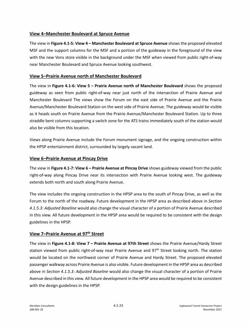
To illustrate the effect of the proposed Project, visual simulations showing the Project from the public viewpoints on Florence Avenue, Market Street, Manchester Boulevard, and Prairie Avenue as identified in Figure 4.1-1: Viewpoint Location Map are provided below.
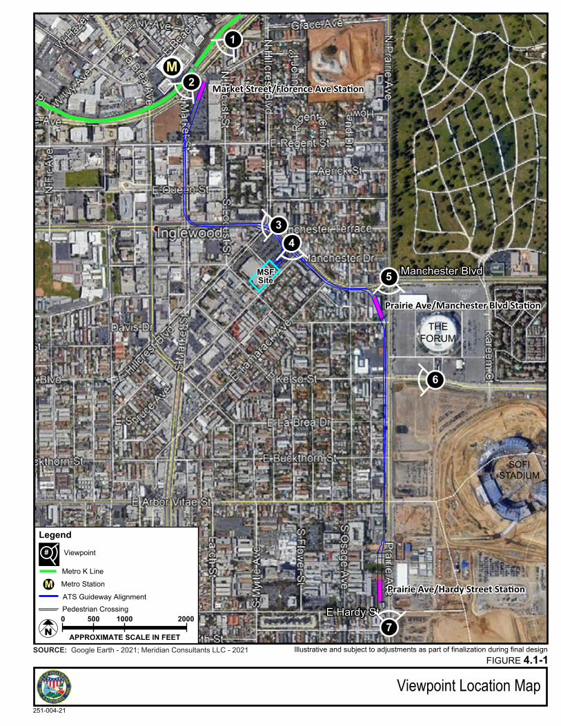
View 1–Florence Avenue at Locust Street
The view in Figure 4.1-2: View 1 – Florence Avenue at Locust Street shows the proposed ATS guideway and the Market Street/Florence Avenue station as it would be viewed looking southwest from the public right-of-way near Florence Avenue and Locust Street. The top of the station structure, the elevated passenger walkway connecting the Market Street/Florence Avenue station to the Metro K line station, support columns and portions of the guideway would be visible from this location.
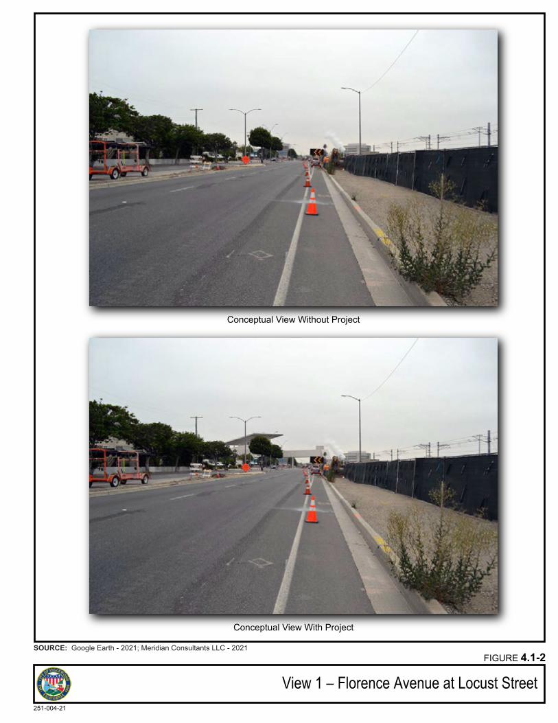
View 2–Market Street at Florence Avenue
The view in Figure 4.1-3: View 2 – Market Street at Florence Avenue shows the proposed Project guideway as it would be viewed from the public right-of-way near Florence Avenue and Market Street. Portions of the Market Street/Florence Avenue station, associated pedestrian stairways, surface parking and guideway would be visible as the guideway enters the public right-of-way on Market Street and heads south.
Under existing conditions, the ongoing construction of a mixed-use project on the west side of Market Street north of Regent is visible, along with portions of the existing commercial center located on the west side of Market Street. Views along Florence Avenue and Market Street currently consist of low-rise commercial development, surface parking, signs, mid-rise office buildings, and the ongoing construction of the Metro K line. Continuing south along Market Street, views include existing low-rise commercial development with street parking and wide sidewalks.
View 3–Manchester Boulevard at Market Street
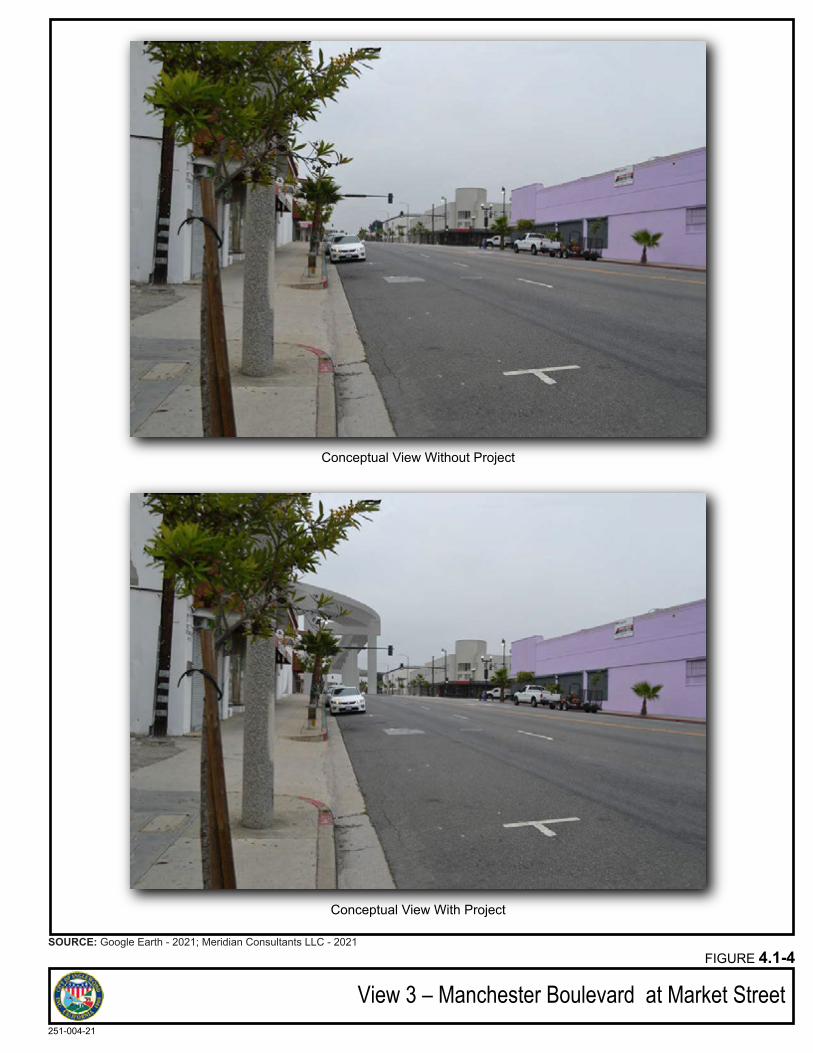
The view in Figure 4.1-4: View 3 – Manchester Boulevard at Market Street shows the proposed guideway as it would be viewed from the public right-of-way just west of Manchester Boulevard and Market Street. The guideway, straddle bent columns and single support columns centered above the proposed median would be visible looking east toward Manchester Boulevard and north toward Market Street as the alignment crosses the intersection and turns from Market Street onto Manchester Boulevard.
Existing commercial development along Manchester Boulevard on both the north and south side of the street is visible. Views along Manchester Boulevard toward Prairie Avenue currently consist of low-rise commercial and residential development, as well as street parking.
Meridian Consultants 4.1-23 Inglewood Transit Connector Project 208-001-18 November 2021
View 4–Manchester Boulevard at Spruce Avenue
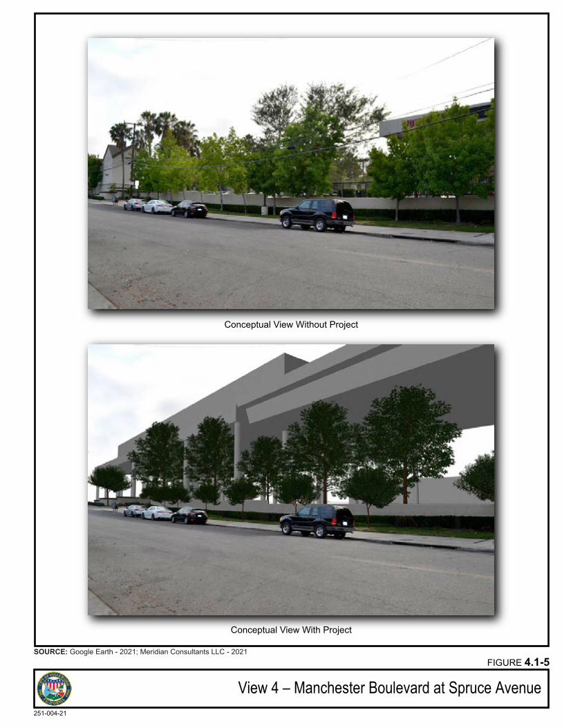
The view in Figure 4.1-5: View 4 – Manchester Boulevard at Spruce Avenue shows the proposed elevated MSF and the support columns for the MSF and a portion of the guideway in the foreground of the view with the new Vons store visible in the background under the MSF when viewed from public right-of-way near Manchester Boulevard and Spruce Avenue looking southwest.
View 5–Prairie Avenue north of Manchester Boulevard
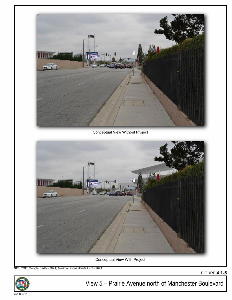
The view in Figure 4.1-6: View 5 – Prairie Avenue north of Manchester Boulevard shows the proposed guideway as seen from public right-of-way near just north of the intersection of Prairie Avenue and Manchester Boulevard The views show the Forum on the east side of Prairie Avenue and the Prairie Avenue/Manchester Boulevard Station on the west side of Prairie Avenue. The guideway would be visible as it heads south on Prairie Avenue from the Prairie Avenue/Manchester Boulevard Station. Up to three straddle bent columns supporting a switch zone for the ATS trains immediately south of the station would also be visible from this location.
Views along Prairie Avenue include the Forum monument signage, and the ongoing construction within the HPSP entertainment district, surrounded by largely vacant land.
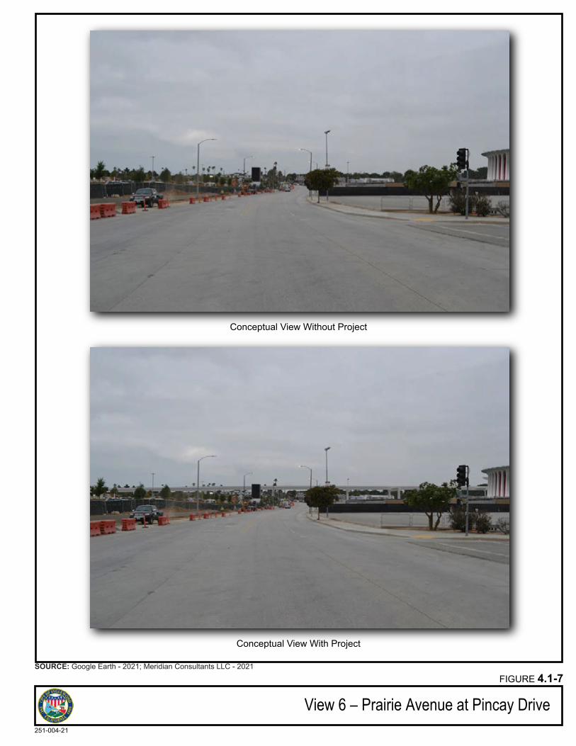
View 6–Prairie Avenue at Pincay Drive
The view in Figure 4.1-7: View 6 – Prairie Avenue at Pincay Drive shows guideway viewed from the public right-of-way along Pincay Drive near its intersection with Prairie Avenue looking west. The guideway extends both north and south along Prairie Avenue.
The view includes the ongoing construction in the HPSP area to the south of Pincay Drive, as well as the Forum to the north of the roadway. Future development in the HPSP area as described above in Section 4.1.5.3: Adjusted Baseline would also change the visual character of a portion of Prairie Avenue described in this view. All future development in the HPSP area would be required to be consistent with the design guidelines in the HPSP.
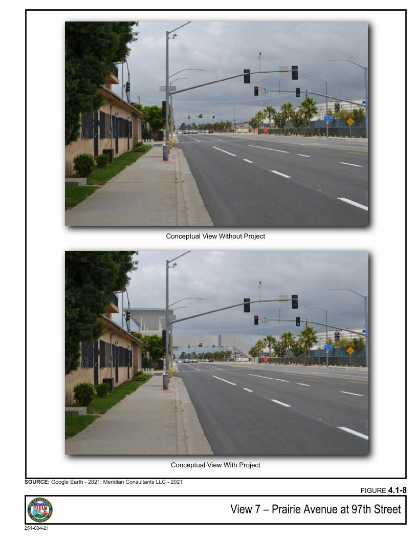
View 7–Prairie Avenue at 97th Street
The view in Figure 4.1-8: View 7 – Prairie Avenue at 97th Street shows the Prairie Avenue/Hardy Street station viewed from public right-of-way near Prairie Avenue and 97th Street looking north. The station would be located on the northwest corner of Prairie Avenue and Hardy Street. The proposed elevated passenger walkway across Prairie Avenue is also visible. Future development in the HPSP area as described above in Section 4.1.5.3: Adjusted Baseline would also change the visual character of a portion of Prairie Avenue described in this view. All future development in the HPSP area would be required to be consistent with the design guidelines in the HPSP.
Manchester Blvd
E Hardy St
Viewpoint Location MapFIGURE 4.1-1
251-004-21
APPROXIMATE SCALE IN FEET
10005000 2000
N
SOURCE: Google Earth - 2021; Meridian Consultants LLC - 2021
Prairie Ave/Manchester Blvd Sta�on
Market Street/Florence Ave Sta�on
Prairie Ave/Hardy Street Sta�on
LegendPotential Locations for APM Stations
Metro StationMATS Guideway AlignmentPedestrian Crossing
SOFISTADIUM
Illustrative and subject to adjustments as part of finalization during final design
M
MSFSite
Metro K Line
1
2
34
5
7
6
# Viewpoint
Conceptual View Without Project
Conceptual View With Project
View 1 – Florence Avenue at Locust StreetFIGURE 4.1-2
251-004-21
SOURCE: Google Earth - 2021; Meridian Consultants LLC - 2021
Conceptual View Without Project
Conceptual View With Project
View 2 – Market Street at Florence AvenueFIGURE 4.1-3
251-004-21
SOURCE: Google Earth - 2021; Meridian Consultants LLC - 2021
Conceptual View Without Project
Conceptual View With Project
View 3 – Manchester Boulevard at Market StreetFIGURE 4.1-4
251-004-21
SOURCE: Google Earth - 2021; Meridian Consultants LLC - 2021
Conceptual View Without Project
Conceptual View With Project
View 4 – Manchester Boulevard at Spruce AvenueFIGURE 4.1-5
251-004-21
SOURCE: Google Earth - 2021; Meridian Consultants LLC - 2021
Conceptual View Without Project
Conceptual View With Project
View 5 – Prairie Avenue north of Manchester BoulevardFIGURE 4.1-6
251-004-21
SOURCE: Google Earth - 2021; Meridian Consultants LLC - 2021
Conceptual View Without Project
Conceptual View With Project
View 6 – Prairie Avenue at Pincay DriveFIGURE 4.1-7
251-004-21
SOURCE: Google Earth - 2021; Meridian Consultants LLC - 2021
Conceptual View Without Project
Conceptual View With Project
View 7 – Prairie Avenue at 97th StreetFIGURE 4.1-8
251-004-21
SOURCE: Google Earth - 2021; Meridian Consultants LLC - 2021
Meridian Consultants 4.1-32 Inglewood Transit Connector Project 208-001-18 November 2021
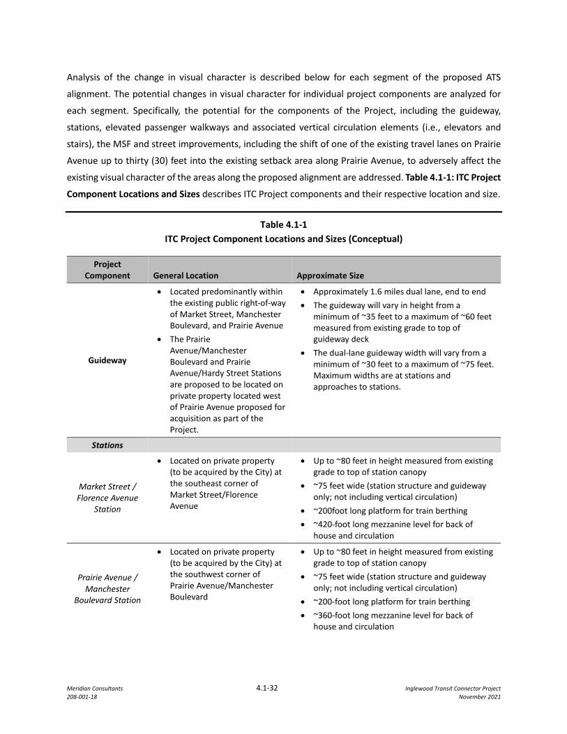
Analysis of the change in visual character is described below for each segment of the proposed ATS
alignment. The potential changes in visual character for individual project components are analyzed for
each segment. Specifically, the potential for the components of the Project, including the guideway,
stations, elevated passenger walkways and associated vertical circulation elements (i.e., elevators and
stairs), the MSF and street improvements, including the shift of one of the existing travel lanes on Prairie
Avenue up to thirty (30) feet into the existing setback area along Prairie Avenue, to adversely affect the
existing visual character of the areas along the proposed alignment are addressed. Table 4.1-1: ITC Project
Component Locations and Sizes describes ITC Project components and their respective location and size.
Table 4.1-1 ITC Project Component Locations and Sizes (Conceptual)
Project Component General Location Approximate Size
Guideway
• Located predominantly within the existing public right-of-way of Market Street, Manchester Boulevard, and Prairie Avenue
• The Prairie Avenue/Manchester Boulevard and Prairie Avenue/Hardy Street Stations are proposed to be located on private property located west of Prairie Avenue proposed for acquisition as part of the Project.
• Approximately 1.6 miles dual lane, end to end • The guideway will vary in height from a
minimum of ~35 feet to a maximum of ~60 feet measured from existing grade to top of guideway deck
• The dual-lane guideway width will vary from a minimum of ~30 feet to a maximum of ~75 feet. Maximum widths are at stations and approaches to stations.
Stations
Market Street / Florence Avenue
Station
• Located on private property (to be acquired by the City) at the southeast corner of Market Street/Florence Avenue
• Up to ~80 feet in height measured from existing grade to top of station canopy
• ~75 feet wide (station structure and guideway only; not including vertical circulation)
• ~200foot long platform for train berthing • ~420-foot long mezzanine level for back of
house and circulation
Prairie Avenue / Manchester
Boulevard Station
• Located on private property (to be acquired by the City) at the southwest corner of Prairie Avenue/Manchester Boulevard
• Up to ~80 feet in height measured from existing grade to top of station canopy
• ~75 feet wide (station structure and guideway only; not including vertical circulation)
• ~200-foot long platform for train berthing • ~360-foot long mezzanine level for back of
house and circulation
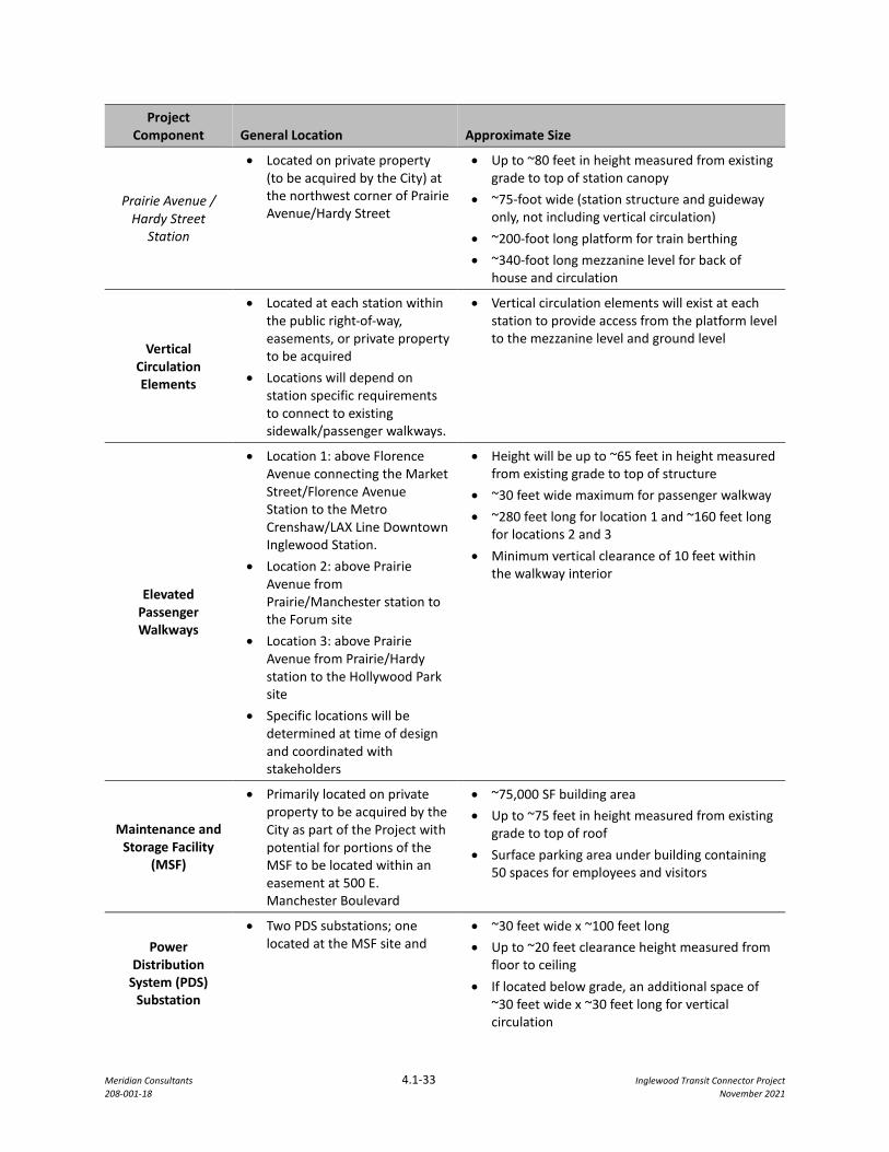
Meridian Consultants 4.1-33 Inglewood Transit Connector Project 208-001-18 November 2021
Project Component General Location Approximate Size
Prairie Avenue / Hardy Street
Station
• Located on private property (to be acquired by the City) at the northwest corner of Prairie Avenue/Hardy Street
• Up to ~80 feet in height measured from existing grade to top of station canopy
• ~75-foot wide (station structure and guideway only, not including vertical circulation)
• ~200-foot long platform for train berthing • ~340-foot long mezzanine level for back of
house and circulation
Vertical Circulation Elements
• Located at each station within the public right-of-way, easements, or private property to be acquired
• Locations will depend on station specific requirements to connect to existing sidewalk/passenger walkways.
• Vertical circulation elements will exist at each station to provide access from the platform level to the mezzanine level and ground level
Elevated Passenger Walkways
• Location 1: above Florence Avenue connecting the Market Street/Florence Avenue Station to the Metro Crenshaw/LAX Line Downtown Inglewood Station.
• Location 2: above Prairie Avenue from Prairie/Manchester station to the Forum site
• Location 3: above Prairie Avenue from Prairie/Hardy station to the Hollywood Park site
• Specific locations will be determined at time of design and coordinated with stakeholders
• Height will be up to ~65 feet in height measured from existing grade to top of structure
• ~30 feet wide maximum for passenger walkway • ~280 feet long for location 1 and ~160 feet long
for locations 2 and 3 • Minimum vertical clearance of 10 feet within
the walkway interior
Maintenance and Storage Facility
(MSF)
• Primarily located on private property to be acquired by the City as part of the Project with potential for portions of the MSF to be located within an easement at 500 E. Manchester Boulevard
• ~75,000 SF building area • Up to ~75 feet in height measured from existing
grade to top of roof • Surface parking area under building containing
50 spaces for employees and visitors
Power Distribution
System (PDS) Substation
• Two PDS substations; one located at the MSF site and
• ~30 feet wide x ~100 feet long • Up to ~20 feet clearance height measured from
floor to ceiling • If located below grade, an additional space of
~30 feet wide x ~30 feet long for vertical circulation

Meridian Consultants 4.1-34 Inglewood Transit Connector Project 208-001-18 November 2021
Project Component General Location Approximate Size
the second at the Prairie/Hardy Station .
• Specific locations within each site will be determined during the design phase
• ~20 feet wide x ~40 feet long additional space for auxiliary equipment such as a backup generator, if necessary
Roadway Improvements
• Market Street, Manchester Boulevard and Prairie Avenue
• New roadway striping, lane re-configurations, partial relocation, on-street parking adjustments, new sidewalks, lighting improvements, traffic signal adjustments, landscaping, and streetscape
Pick-Up/Drop-Off Areas, Surface
Parking Lots and Staging Areas
During Construction
• Market Street/Florence Avenue Station site
• 150 S. Market Street • Prairie Avenue/Hardy Street
Station
Surface level parking at each site: • ~650 spaces at Market Street/Florence Station • ~50 spaces at 150 S. Market Street • ~100 spaces at Prairie/Hardy Station
Pick-Up/Drop-Off Area: • Market Street/Florence Avenue Station site on
Locust Street south of Florence Avenue, and Regent Street between Locust Street and Market Street
• Prairie/Hardy Street Station within the station site
Market Street Segment
Market Street/Florence Avenue Station
The Market Street/Florence Avenue Station would be a focal point of the proposed Project, connecting
the ATS system to the Metro K line Downtown Inglewood Station. The Market Street/Florence Avenue
station would replace the existing commercial center at 300 E. Florence Avenue. The station would be
designed in conformance with the Design Standards and Guidelines as a sleek and horizontal station design
with a distinctive, modern style. The lightly colored canopy over the platform would be the dominant
architectural feature, providing shade and protection from inclement weather while allowing for natural
ventilation and daylight. Vertical circulation including escalators, stairs, and elevators would be included
as part of the station. The elevators and associated enclosures would be constructed using transparent
glass to contribute to a modern exterior design while allowing unobstructed views from all sides. For
approximate station dimensions, please refer to Table 4.1-1.
The station exterior would be composed of exposed concrete with a light colored canopy material. The
exposed exterior of the structure would be made with materials resistant to graffiti and vandalism to
reduce the potential for unsightly defaced properties. The neutral tone of the station would allow it to
Meridian Consultants 4.1-35 Inglewood Transit Connector Project 208-001-18 November 2021
blend in with its surroundings. The platform and mezzanine guardrails would be as transparent as possible
to enhance the integration of the station with the surrounding environment. The Design Standards and
Guidelines call for the final design of this station to reflect the unique character of downtown Inglewood
to further integrate the structure into the existing public realm along Market Street.
A drop-off/pick-up area on Locust Avenue and Regent Street to facilitate multiple travel modes would be
located adjacent to this station along with a surface parking lot to accommodate ATS riders and consolidate
parking while reducing the need to park on adjacent streets and at nearby businesses. Consistent with the
Design Standards and Guidelines new landscaping and site improvements to provide shade and decorative
separation of parking spaces would be provided. The proposed surface parking lot would improve the
visual character of the existing surface parking lot at the same location.
Elevated Passenger walkway
An elevated passenger walkway would connect the Market Street/Florence Avenue Station with the Metro
K Line Downtown Inglewood Station. This passenger connection would be elevated and span over Florence
Avenue and would be visually integrated with the design of the Market Street/Florence Avenue Station
and Metro K Line Downtown Inglewood Station. This walkway would be simple in design and form to
deliver functionality and protect passengers from inclement weather. The exterior of the walkway,
elevators and associated enclosures would be constructed with transparent material to the extent feasible
to provide a contemporary and appealing aesthetic while providing as much natural daylight and
unobstructed views for pedestrians. Neutral tones would be used in areas of the structure where
transparent material cannot be used to further integrate the elevated passenger walkway with the
surrounding structures. Visually unobstructive barriers would be integrated into the walkway design to
ensure both pedestrian and roadway safety.
ATS Guideway
The guideway in this segment would exit the existing commercial center site at the intersection of Market
Street and Regent Street and continue south above the Market Street right of way until Manchester
Boulevard where the guideway would turn east. The guideway would be supported by single columns until
it reaches Manchester Boulevard. The columns would be primarily located in the existing median area
along Market Street between Regent Street to Manchester Boulevard.
PDF CUL-1 would be incorporated into the project to minimize impacts to the historic buildings along
Market Street as called for in the Design Standards and Guidelines, discussed further below.
Meridian Consultants 4.1-36 Inglewood Transit Connector Project 208-001-18 November 2021
The design of the guideway would be streamlined and horizontal in expression. As required by PDF CUL-
1, columns would be positioned in the middle of the roadway with as much space in between columns as
is feasible, away from storefronts and adjacent buildings, to support the guideway structure. The drawings
in Appendix D: Conceptual Project Design of the Historical Resources Technical Report (Appendix I.2) show
the relationship of these components of the Project to individual historic resources located along the
proposed alignment.
Where possible, the dual-lane guideway would be narrowed and configured to facilitate the use of single
columns to support the structure to minimize the visual mass of the guideway. With the revised Project
design, the amount of the guideway that would be supported by single columns has been maximized along
Market Street, Manchester Boulevard, and Prairie Avenue. Specifically, shifting the guideway to the west
side or Prairie Avenue allows for the guideway between the Prairie Avenue/Manchester Boulevard and
Prairie Avenue/Hardy Street stations to be supported by single columns to minimize changes to existing
visual character of Prairie Avenue. The conceptual guideway alignment plans and column placements are
shown in Appendix E: ITC Operating Systems. The guideway would be constructed of exposed neutral
colored concrete or similar with tapered edges to reduce perceived massing. Guideway transitions at
crossovers would be smooth and rounded with all conduits, guideway equipment, walkways, drainage
systems, and other utilities concealed from the ground view. Overall, the guideway would be simple, clean,
respectful of the surrounding environment and complimentary to the station designs.
Historic Resources and Character
Five historical resources were identified on Market Street along the proposed alignment for the ATS
guideway:
• Former Bank of Inglewood (100 Market Street);
• Former Fox Theater (115 Market Street);
• Former United Bank of California (158-170 Market Street);
• Former J.C. Penney (129-139 Market Street); and
• Professional Building (149-155 Market Street)
The elevation and distance of the guideway from the façade of these historical buildings on Market Street will be sufficient for the guideway to visually clear the top of the façades of these buildings when viewed from Market Street as required by PDF CUL-1. At the Fox Theater, and for 100 feet on either side of the Fox Theater building, the guideway elevation will be a minimum of 52 feet from grade in order to maintain unobstructed views of pylon sign and front façade of the building. The guideway will have a width of approximately 32 feet and will be supported by single round columns in the median of Market Street with
Meridian Consultants 4.1-37 Inglewood Transit Connector Project 208-001-18 November 2021
a diameter of 8 feet. The elevation and distance of the guideway from the façades of these historic buildings will be sufficient for the guideway to visually clear the top of the historical resources’ street-facing façade. when viewed from the optimal viewpoints. The dimensions, placement, and spacing of the guideway support columns will also avoid or minimize obstructions of the view of the facades of these historic buildings along Market Street. The final Project design is expected to achieve no visual obstruction of any of the identified historical resources along Market Street from the guideway.
The scale, massing, and overall composition of these historic buildings would remain readily discernable to the viewer despite some interruption of views by the proposed Project and would still convey their historic significance as historic resources. As such, the project would not substantially degrade the existing visual character of these six historic resources and impacts would be less than significant.
Streetscape
The Design Standards and Guidelines include public realm guidelines addressing landscape and the interface of the Project with the existing streets. Under the Design Standards and Guidelines, this segment of the streetscape is designed to complement standards and guidelines outlined within the Downtown TOD Plan24 while accommodating Project needs. Specifically, the existing streetscape design and aesthetics as described in the existing conditions would be maintained to the extent feasible while providing necessary upgrades such as ADA-compliant ramps. The sidewalks would be designed to be as wide as possible to allow for comfortable pedestrian travel. Plazas with street furniture would provide places to gather and encourage social interaction. The design of the street furniture would complement the overall design of the proposed streetscape improvements. Separation of pedestrians from the roadway using the recommended street trees per the Design Standards and Guidelines would be incorporated to maintain the character of the historic core along Market Street. Street trees and landscaping would be provided where possible to provide shade and create a walkable pedestrian pathway. Trees would be arranged to create a continuous canopy over the pedestrian realm where feasible. Trees would be planted on both sides of the roadway where feasible and would be positioned relative to the guideway columns to create a consistent visual rhythm. Street trees and new landscaping would be planted within the median below the ATS guideway along Market Street to enhance the aesthetic quality of the roadway. Street furniture and street tree concepts would be consistent with the Design Standards and Guidelines, which include consideration of the street furniture and street tree concepts set forth in the Downtown TOD Plan, Section 2.8, Street Trees and Furniture. These streetscape improvements would enhance the visual character of Market Street in Downtown Inglewood and assist in visually integrating the guideway into Market Street.
24 City of Inglewood. New Downtown and Fairview Heights Transit Oriented Development Plan and Design Guidelines.
Adopted November 1st, 2016. http://inglewood.arroyogroup.com/wp-content/uploads/2017/01/The-New-Downtown-Fairview-Heights-TOD-Plan-Design-Guidelines-lo-res.pdf.
Meridian Consultants 4.1-38 Inglewood Transit Connector Project 208-001-18 November 2021
Shade and Shadow
New shade and shadow patterns in the Market Street segment would be created by the ATS guideway structure and the Market Street/Florence Avenue station. Uses sensitive to shading along Market Street include residential uses and outdoor spaces associated with residential or recreational uses and solar panels.
The Market Street/Florence Avenue station would be located on the southeast corner of Market Street and Florence Avenue. The station’s shadow would be cast furthest during sunset on a summer evening and on a winter morning as shown in Figure 4.1-12 and Figure 4.1-13. The shadow would be cast northwest over Florence Avenue on a winter morning and southeast on a winter afternoon as shown in Figure 4.1-13 and Figure 4.1-15. As the surrounding land uses are commercial, no sensitive receptors are present and no shade and shadow impacts to surrounding uses are anticipated. There are no existing solar panels in this segment identified through review of aerial photographs.25
The ATS guideway within the Market Street right of way would run the entirety of the segment from south of Regent Street to Manchester Boulevard on single support columns above the roadway median. With single support columns spaced as far apart as feasible and the bottom of the guideway raised 40 feet above Market Street, the shadows created would be narrow and would not affect large areas at any point during the day. The shadow from the guideway would be west of Market Street in the morning and east of Market Street in the afternoon. This narrow shadow pattern would also move throughout the day from northwest to southeast. No areas would be shaded for long periods as shown in Figures 4.1-9 through 4.1-15. For these reasons, no adjacent properties will be substantially shaded for long periods of time during the day and impacts from shading will be less than significant.
Manchester Boulevard Segment
ATS Guideway
The guideway in this segment would travel the entire length of Manchester Boulevard between Market Street to Prairie Avenue. As the guideway turns east onto Manchester Boulevard, the guideway would transition from single columns to one-half straddle bent to support the turn onto Manchester Boulevard before going back to single columns in a new median located in Manchester Boulevard. The guideway would widen as it approaches the MSF and require straddle bents that will span across Manchester Boulevard. From the MSF to Prairie Avenue, a combination of single column supports and straddle bents across Manchester Boulevard would be used to support the guideway.
25 Google Earth, 2020.
Meridian Consultants 4.1-39 Inglewood Transit Connector Project 208-001-18 November 2021
The guideway would travel above the existing two-to-four-lane roadway. PDF CUL-1 would be incorporated into the project to minimize impacts to the historic buildings along the Manchester Boulevard as called for in the Design Standards and Guidelines, discussed further below.
The design of the guideway would be streamlined and horizontal in expression. As required by PDF CUL-1, columns would be positioned in the middle of the roadway with as much space in between columns as is feasible, away from storefronts and adjacent buildings, to support the guideway structure. The design of the guideway would continue to be streamlined and horizontal in expression for integration into the existing built environment. Support columns would be spaced apart with as much distance in between as is feasible to reduce aesthetic impacts to travelers on the ground level and nearby land uses. Where possible, the dual lane guideway would be narrowed and configured to facilitate the use of single columns to support the structure, thus minimizing visual massing. Conceptual guideway alignment plans and column placements are detailed in Appendix E. The guideway would be constructed of exposed concrete or similar with tapered edges to reduce perceived massing and would use neutral colors and lightly colored canopies to minimize urban heat island effect. Transitions at crossovers would be smooth and rounded with all conduits, guideway equipment, walkways, drainage systems, and other utilities concealed from the ground view. Overall, the guideway would be simple, clean, respectful of the surrounding environment.
Maintenance and Storage Facility
The MSF is proposed on the southwest corner of Manchester Boulevard and Spruce Avenue on a site developed with an existing Vons grocery store. A new replacement Vons grocery will be built on the northwest corner of Manchester Boulevard and Hillcrest Boulevard. The Design Standards and Guidelines require the massing and height of the MSF to be minimized to be as unobtrusive to adjacent neighbors as possible while maintaining functionality and allowing roof access. All rooftop equipment would be fully screened to prevent unsightly views from the ground and adjacent buildings. Building exterior would be covered in a uniform and neutral color to allow proper integration of the structure with the adjacent aesthetic environment. To prevent unsightly graffiti and vandalism, and to reduce the required amount of exterior maintenance, the exterior material of the MSF would be graffiti-resistant.
The MSF would be elevated to match the guideway height. The new Vons grocery store would be located on the northwest portion of the MSF site near the intersection of Manchester Boulevard and Hillcrest Boulevard. The maintenance level for ATS train cars would match the guideway track elevation and will contain mezzanine administrative office space. The ground level would include multiple rows of columns and support beams for structural support. The ground level would consist of a generally unenclosed space containing public parking for the new Vons store. The visual character of the new surface parking lot would be similar to the existing parking lot at the proposed MSF site, with black asphalt and striped spaces
Meridian Consultants 4.1-40 Inglewood Transit Connector Project 208-001-18 November 2021
throughout the lot. The Design Standards and Guidelines would require trees and new landscaping as feasible to provide shade and decorative separation of parking spaces.
The MSF would include decorative security walls and fences along the edges of the facility to shield view of the MSF from public view as called for in the Design Standards and Guidelines. Decorative screening walls and fences would be designed to completely enclose all mechanical equipment while allowing for sufficient airflow. All solid fences or walls would be articulated with similar or complementary materials and colors to the building. Any long expanses of walls and fences would be broken up with projections or recessed elements, landscape pockets and changes in materials or textures. Landscape elements, such as vines to create a green wall or screen, would be used in combination with walls and fences to ensure the Project is visually compatible with adjacent uses.
Historic Resources and Character
There is one identified historical resource, the Bank of America building located at 320 Manchester Boulevard, on this segment. The scale, massing, and overall composition of this building would remain readily discernable to the viewer despite some interruption of views by three of the guideway columns. Only a small portion of the primary façade of the building would be intermittently obscured depending on the position of the viewer. As described in PDF CUL-1, views that are completely unobstructed by support columns are not necessary for the Bank of America building to convey its significance due to its scale and/or setback.
Streetscape
Under the Design Standards and Guidelines, the Manchester Boulevard segment between Market Street and Locust Street is designed to complement the standards and guidelines outlined within the Downtown TOD Plan,26 similar to the Market Street segment. Necessary upgrades such as ADA-compliant ramps would be integrated within the Project area as applicable. The sidewalks would be designed to be as wide as possible to allow for places to sit and gather and encourage social interaction which would enhance the attractiveness of the sidewalk. Integrated landscaping along the sidewalk would enhance the attractiveness of the public realm and provide a walkable environment along Manchester Boulevard. Plazas with street furniture provide places to gather and encourage social interaction. The design of the street furniture would complement the overall design of the proposed streetscape improvements.
Separation of pedestrians from the roadway using street trees would be incorporated per the Guidelines. Trees would be planted in a pattern and frequency consistent with existing street trees east and west of the proposed Project in alignment with the shape of the roadway as required by PDF AES-4. Street trees
26 City of Inglewood. New Downtown and Fairview Heights Transit Oriented Development Plan and Design Guidelines.
Adopted November 1st, 2016. http://inglewood.arroyogroup.com/wp-content/uploads/2017/01/The-New-Downtown-Fairview-Heights-TOD-Plan-Design-Guidelines-lo-res.pdf. Accessed November 30, 2020.
Meridian Consultants 4.1-41 Inglewood Transit Connector Project 208-001-18 November 2021
and new landscaping would be planted within the median below the ATS guideway along Manchester Boulevard to enhance the aesthetic quality of the roadway. Street furniture and street trees concepts would be consistent with the Design Standards and Guidelines, which include coordinating street furniture and street trees included in the ITC Project with the concepts defined in the Downtown TOD Plan, Section 2.8, Street Trees and Furniture.
Shade and Shadow
New shade and shadow patterns along the Manchester Boulevard segment would be created by the ATS guideway structures and the MSF. The PDS substation in this segment would be located at the MSF site and, given its size it would not create shadow patterns large enough to encroach on adjacent uses at any point during the year or in the day. Shade and shadow sensitive uses in this segment include the residential uses to the northeast of the segment, west of Osage Avenue. No existing solar panels in this segment that were identified through review of aerial photography.27
The MSF would be located off the public right of way on the southeast corner of Manchester Boulevard and Hillcrest Boulevard. The building’s shadow would be cast furthest on a winter morning and during sunset on a winter evening. Given the dimension of the building and its distance from surrounding uses, the shadow cast by the building would be entirely contained within the MSF site. As the shade and shadow of the building would be completely contained within the site, no sensitive receptors would be present and no shade and shadow impacts to the surrounding uses is anticipated.
The guideway would be located entirely within the public right of way of Manchester Boulevard. With single support columns spaced as far apart as feasible and the bottom of the guideway raised 40 feet above Manchester Boulevard, the shadows created would be narrow and would not affect large areas at any point during the day. This narrow shadow pattern would also move throughout the day, from northwest to southeast. No areas would be shaded for long periods as shown in Figure 4.1-16 through Figure 4.1-19. For these reasons, no adjacent properties will be substantially shaded for long periods of time during the day.
As the shadow of the guideway would not be extensive and no adjacent property would be shaded for a substantial portion of the day, the proposed Project would have a less than significant shade and shadow impact on the surrounding uses in this segment.
27 Google Earth, 2020.
Market Street and Manchester Boulevard, June 22 at 9:00 AMFIGURE 4.1-9
251-003-21
SOURCE: Meridian Consultants LLC - 2021
Floren
ce Ave
nue
Mar
ket
Stre
et
Regent Street
Queen Street
Manchester Boulevard
Hillc
rest
Bou
leva
rd
Market Street Segment and Manchester Boulevard Segment betweenFlorence Avenue and Hillcrest Boulevard
Locu
st S
treet
N
Market Street and Manchester Boulevard, June 22 at 12:00 PMFIGURE 4.1-10
251-003-21
SOURCE: Meridian Consultants LLC - 2021
Floren
ce Ave
nue
Mar
ket
Stre
et
Regent Street
Queen Street
Manchester Boulevard
Hillc
rest
Bou
leva
rd
Market Street Segment and Manchester Boulevard Segment betweenFlorence Avenue and Hillcrest Boulevard
Locu
st S
treet
N
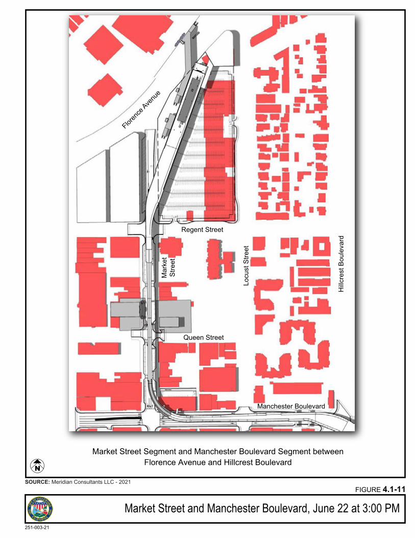
Market Street and Manchester Boulevard, June 22 at 3:00 PMFIGURE 4.1-11
251-003-21
SOURCE: Meridian Consultants LLC - 2021
Floren
ce Ave
nue
Mar
ket
Stre
et
Regent Street
Queen Street
Manchester Boulevard
Hillc
rest
Bou
leva
rd
Market Street Segment and Manchester Boulevard Segment betweenFlorence Avenue and Hillcrest Boulevard
Locu
st S
treet
N
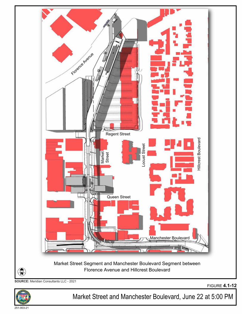
Market Street and Manchester Boulevard, June 22 at 5:00 PMFIGURE 4.1-12
251-003-21
SOURCE: Meridian Consultants LLC - 2021
Floren
ce Ave
nue
Mar
ket
Stre
et
Regent Street
Queen Street
Manchester Boulevard
Hillc
rest
Bou
leva
rd
Market Street Segment and Manchester Boulevard Segment betweenFlorence Avenue and Hillcrest Boulevard
Locu
st S
treet
N
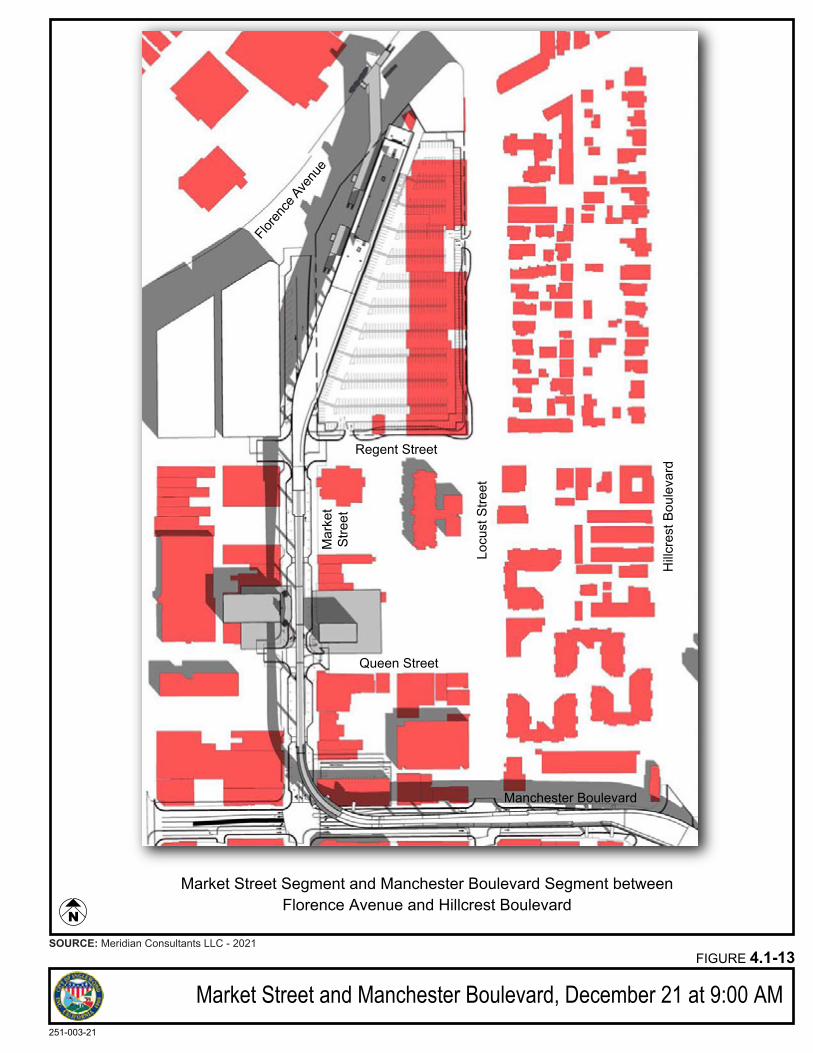
Market Street and Manchester Boulevard, December 21 at 9:00 AMFIGURE 4.1-13
251-003-21
SOURCE: Meridian Consultants LLC - 2021
Floren
ce Ave
nue
Mar
ket
Stre
et
Regent Street
Queen Street
Manchester Boulevard
Hillc
rest
Bou
leva
rd
Market Street Segment and Manchester Boulevard Segment betweenFlorence Avenue and Hillcrest Boulevard
Locu
st S
treet
N
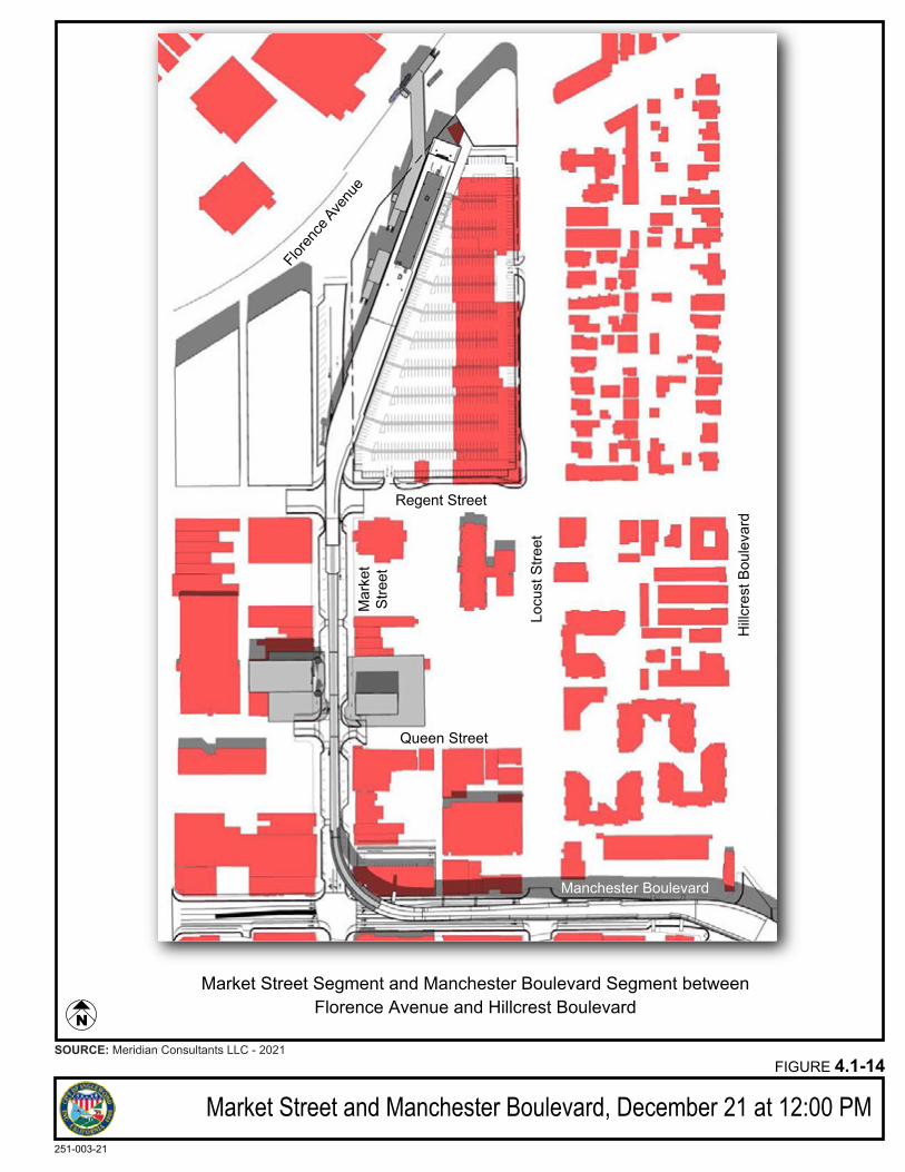
Market Street and Manchester Boulevard, December 21 at 12:00 PMFIGURE 4.1-14
251-003-21
SOURCE: Meridian Consultants LLC - 2021
Floren
ce Ave
nue
Mar
ket
Stre
et
Regent Street
Queen Street
Manchester Boulevard
Hillc
rest
Bou
leva
rd
Market Street Segment and Manchester Boulevard Segment betweenFlorence Avenue and Hillcrest Boulevard
Locu
st S
treet
N
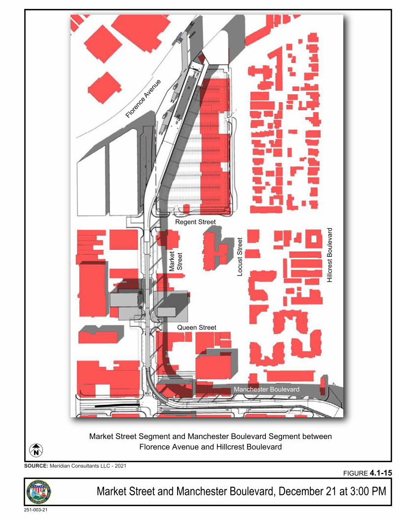
Market Street and Manchester Boulevard, December 21 at 3:00 PMFIGURE 4.1-15
251-003-21
SOURCE: Meridian Consultants LLC - 2021
Floren
ce Ave
nue
Mar
ket
Stre
et
Regent Street
Queen Street
Manchester Boulevard
Hillc
rest
Bou
leva
rd
Market Street Segment and Manchester Boulevard Segment betweenFlorence Avenue and Hillcrest Boulevard
Locu
st S
treet
N
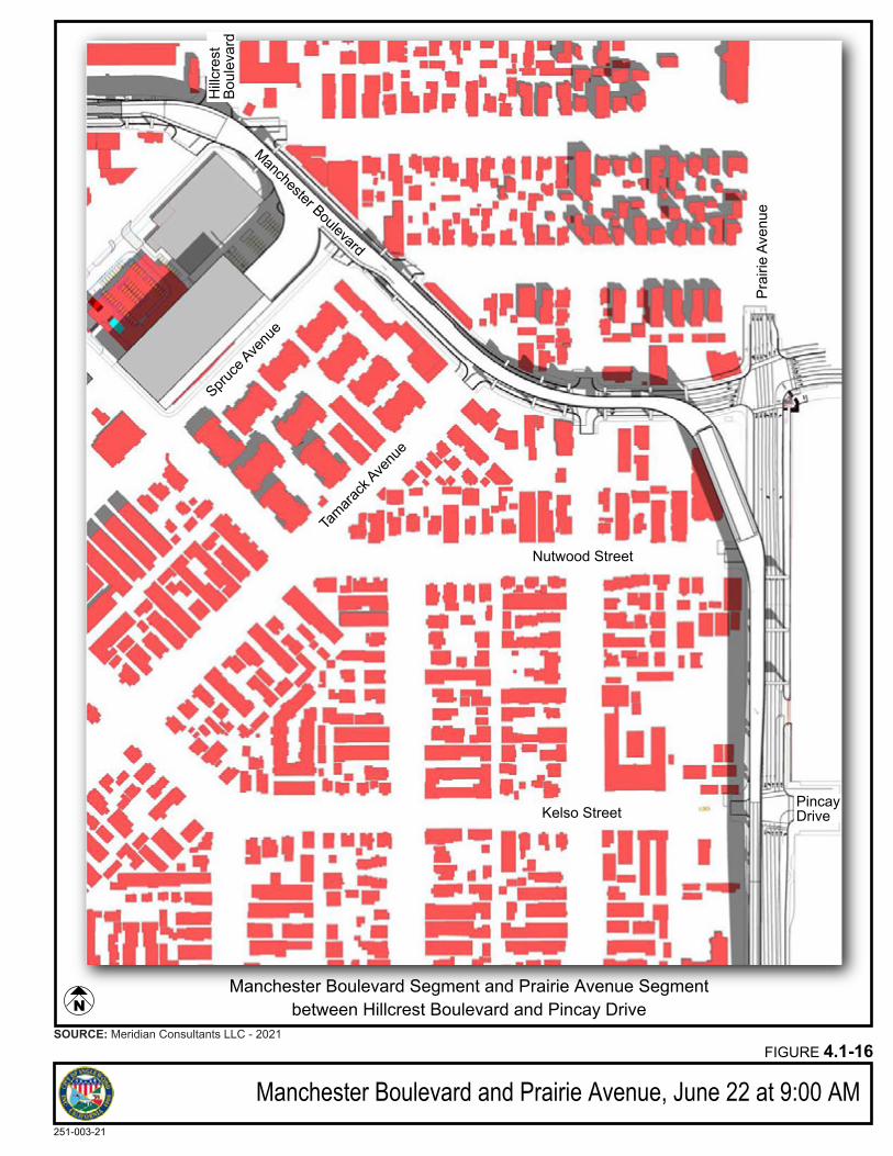
Manchester Boulevard and Prairie Avenue, June 22 at 9:00 AMFIGURE 4.1-16
251-003-21
SOURCE: Meridian Consultants LLC - 2021
Spruce
Avenu
e
Nutwood Street
Kelso Street
Manchester Boulevard
Prai
rie A
venu
e
Manchester Boulevard Segment and Prairie Avenue Segmentbetween Hillcrest Boulevard and Pincay Drive
PincayDrive
Tamara
ck Ave
nue
Hillc
rest
Boul
evar
d
N
Meridian Consultants 4.1-50 Inglewood Transit Connector Project 208-001-18 November 2021
Prairie Avenue Segment
Prairie Avenue/Manchester Boulevard Station and Prairie Avenue/Hardy Street Station
The design of Prairie Avenue/Manchester Boulevard and Prairie Avenue/Hardy Street stations would be
similar to the Market Street/Florence Avenue station, with a sleek, horizontal station design with a
distinctive, modern style to enhance the aesthetic appearance of the structures and the identity of the
proposed Project. The stations would include ground, mezzanine, and platform levels. The station exteriors
would be composed of exposed concrete with a light colored canopy material. The light colored canopies
would be the dominant architectural feature providing shade and protection from inclement weather
while allowing for natural ventilation and daylight. Vertical circulation elements including escalators, stairs,
elevators, and associated enclosures would be constructed using transparent glass to contribute to a
modern exterior while allowing unobstructed views from all sides. Wherever possible, transparent screen
walls and railings of the appropriate height would be integrated as part of the stations to enhance the
appearance of the stations and integrate the structures with their surroundings. Where transparent
materials cannot be used, a neutral color palette would be used to add to the modern style of the station.
Surface materials used for the station would be resistant to graffiti and vandalism to prevent deterioration
and unsightly views of the exteriors. The final design of the station would complement the new
surrounding development along Prairie Avenue to visually integrate the proposed Project with the
surrounding area.
Elevated Passenger walkways
One elevated passenger walkway would be constructed to connect the Prairie Avenue/Manchester
Boulevard station with the site of the Forum and another would be constructed to connect the Prairie
Avenue/Hardy Street station with the east side of Prairie Avenue adjacent to the Hollywood Park Specific
Plan area located on the east side of Prairie Avenue. These passenger connections would be elevated and
span over Prairie Avenue and would be designed to visual integrate with their respective ATS stations.
These walkways would be simple in design and form to deliver functionality and protect passengers from
inclement weather. The exterior of the walkways, elevators and associated enclosures would be
constructed with transparent material to the extent feasible to provide a contemporary and appealing
aesthetic while providing as much natural daylight and unobstructed views for pedestrians. Neutral tones
would be used in areas of the structures where transparent material cannot be used to further integrate
the elevated passenger walkways with the surrounding stations and guideway structures. Visually
unobstructive barriers would be integrated into walkway design to ensure both pedestrian and roadway
safety.
Meridian Consultants 4.1-51 Inglewood Transit Connector Project 208-001-18 November 2021
ATS Guideway
The guideway in this segment would travel the length of Prairie Avenue from Manchester Boulevard to
Hardy Street. Upon exiting the Prairie Avenue/Manchester Boulevard station and continuing south, the
elevated guideway would continue along the west side of Prairie Avenue until both tracks gradually
transition together immediately north of Kelso Street and continue in this configuration south to Victory
Street, where the tracks diverge to enter into the Prairie Avenue/Hardy Street station on the northwest
corner of the Prairie Avenue and Hardy Street intersection. Three Straddle bent columns would support
this segment of the guideway as it proceeds south onto Prairie Avenue just past Nutwood Street. As the
guideway converges, the structure would transition to single column supports located on the western side
of Prairie Avenue. This portion of the guideway would diverge south of Victory Street to the west of Prairie
Avenue as it approaches the Prairie Avenue/Hardy Street station and would be supported by straddle
bents in the sidewalk and west of the public right of way.
The design of the guideway would continue to be streamlined and horizontal in expression to support
integration into the existing environment and the anticipated new developments on the east side of Prairie
Avenue. Columns would be spaced apart with as much distance in between as is feasible to reduce
aesthetic impacts to travelers on the ground level and nearby land uses. Where possible, the dual lane
guideway would be narrowed and configured to facilitate the use of single columns to support the
structure, thus minimizing visual massing. For conceptual guideway alignment plans and column
placements, please refer to Appendix E. The guideway would be constructed of exposed concrete or
similar with tapered edges to reduce perceived massing. The guideway would use neutral colors and lightly
colored canopies to minimize urban heat island effect. Transitions at crossovers would be smooth and
rounded with all conduits, guideway equipment, walkways, drainage systems, and other utilities concealed
from the ground view. Overall, the guideway would be simple, clean, respectful of the surrounding
environment.
Historic Resources and Character
There are two identified historical resources in this segment: the Forum located at 3900 Manchester
Boulevard and the Lighthouse McCormick Mortuary located at 619 Prairie Avenue along this segment. The
scale, massing, and overall composition of the Forum and the Lighthouse McCormick Mortuary would
remain readily discernable to the viewer despite some interruption of views by the stations, guideway and
guideway columns and would still convey their historic significance as historic resources. As such, the
project would not substantially degrade the existing visual character of these two historic resources and
impacts would be less than significant.
Meridian Consultants 4.1-52 Inglewood Transit Connector Project 208-001-18 November 2021
Streetscape
The entire segment not directly adjacent to the HPSP development area would be governed by local
ordinances and the Design Standards and Guidelines. The sidewalk zones would be constructed as wide
as possible on both sides of the street, with planting zones between the sidewalk and the street where
feasible. The sidewalks would be designed to be as wide as possible to allow for comfortable pedestrian
travel. Integrated landscaping along the sidewalk would enhance the attractiveness of the public realm
and provide a walkable environment along Prairie Avenue. Plazas with street furniture would provide
places to gather and encourage social interaction. The design of the street furniture would complement
the overall design of the proposed streetscape improvements. Street trees and landscaping would be
provided where possible to provide shade and create a walkable pedestrian pathway. Street trees on the
east side of Prairie Avenue would continue the existing placement of those from the Inglewood Cemetery,
north of Manchester Boulevard. Street trees on the west side of Prairie Avenue would be spaced to match
the placement of both the elevated guideway support columns and street trees on the east side of the
roadway. The planting of street trees and integrated landscaping along the sidewalk on Prairie Avenue
would enhance the attractiveness of the streets. Planting zones would also be incorporated into roadway
medians where feasible to enhance the aesthetic quality of the roadway.
To accommodate the proposed ATS while maintaining the existing roadway capacity along Prairie Avenue,
the ITC Project includes the proposed relocation of one existing traffic lane on the east side of Prairie
Avenue within a variable easement for street purposes, to be acquired by the City over private property
that currently comprises the existing 30-foot setback area along the west edge of the HPSP area. While existing sidewalk widths along Prairie would be maintained, some of the existing landscaping, signs and
other streetscape improvements would be reduced or eliminated in certain locations.
Adjacent to the HPSP on the east side of Prairie Avenue, between Arbor Vitae Street and Hardy Street, the
Design Standards and Guidelines define a streetscape design complementary to the streetscape design
guidelines for the HPSP project.28 The HPSP streetscape plan is designed to create a diverse urban forest
that will integrate development in Hollywood Park with the adjoining urban fabric and assist in developing districts of distinctive and appropriate character. Tree selections on Prairie Avenue in the HPSP design
guidelines consist of Afghan Pine, Camphor Tree, Southern Magnolia, and Canary Island Pine trees. Prairie
Avenue adjacent to HPSP would include residential and retail gateways, with the goal of providing an
appealing environment for pedestrians and vehicles traveling along Prairie Avenue. All existing
28 Hollywood Park Lan Company, LLC. Hollywood Park Specific Plan.
https://www.cityofinglewood.org/DocumentCenter/View/1347/Hollywood-Park-Specific-Plan. Adopted July 8, 2009, Amended September 23, 2014, Amended February 24, 2015.
Meridian Consultants 4.1-53 Inglewood Transit Connector Project 208-001-18 November 2021
landscaping, signs and other streetscape improvements reduced or eliminated as a result of
implementation of the Project will be replaced consistent with the Design Standards and Guidelines.
Shade and Shadow
New shade and shadow patterns in the Prairie Avenue segment would be created by the ATS guideway
structures, the Manchester Boulevard/Prairie Avenue, and the Prairie Avenue/Hardy Street stations. Nearby shade and shadow sensitive uses include residential uses west of Prairie Avenue. No existing solar
panels in this segment that were identified through review of aerial photographs.29
The Manchester Boulevard/Prairie Avenue and the Prairie Avenue/Hardy Street stations would both be
located immediately west of Prairie Avenue. The stations would cast shadows furthest on a winter morning
as shown in Figure 4.1-20 and Figure 4.1-27, and during a winter evening as shown in Figure 4.1-22 and
Figure 4.1-29. The winter morning shadows from the stations would be almost entirely contained on the station sites and no uses sensitive to shading would be affected. Winter mid-day and afternoon shadows
would not affect any adjacent uses. The shorter shadows during summer and other times of year would
also not affect any adjacent uses sensitive to shading.
The guideway would run the entirety of the segment from Manchester Boulevard to Hardy Street on the
west side of Prairie Avenue adjacent to the roadway. With single support columns spaced as far apart as
feasible and the bottom of the guideway raised 40 feet adjacent to the west side of the roadway, the shadows created would be narrow and would not affect large areas at any point during the day. This
narrow shadow pattern would also move throughout the day from northwest to southeast. No areas
would be shaded for long periods as shown in Figure 4.1-17 through Figure 4.1-29. For these reasons, no
adjacent properties will be substantially shaded for long periods of time during the day.
Uses adjacent to the planned location of the guideway along the west side of Prairie Avenue include
commercial, residential, and institutional uses, including the Kelso Elementary School and the Daycare Center. The recreational areas of these facilities are considered shade sensitive uses. Only the western
edge of the Kelso School campus would be shaded during mornings from the guideway and majority of
the campus would not be shaded during any portion of the day. No portion of the campus would be shaded
in the afternoon. The impact of shading on the Kelso School campus, therefore, would be less than
significant.
29 Google Earth, 2020.
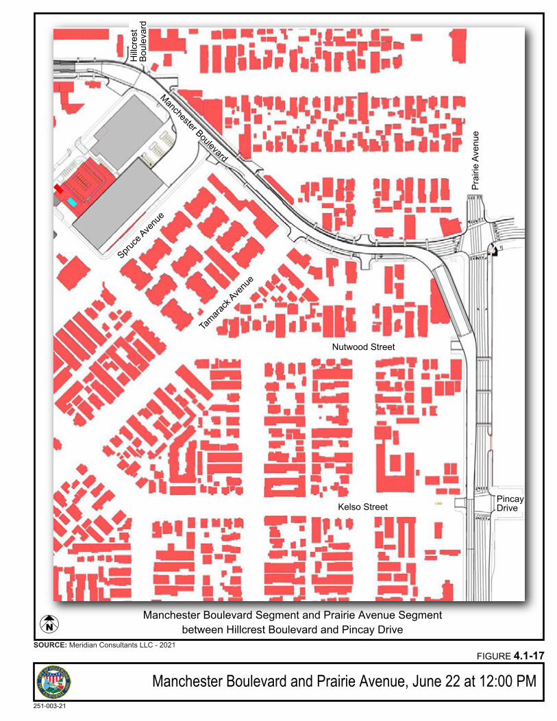
Manchester Boulevard and Prairie Avenue, June 22 at 12:00 PMFIGURE 4.1-17
251-003-21
SOURCE: Meridian Consultants LLC - 2021
Spruce
Avenu
e
Nutwood Street
Kelso Street
Manchester Boulevard
Prai
rie A
venu
e
Manchester Boulevard Segment and Prairie Avenue Segmentbetween Hillcrest Boulevard and Pincay Drive
PincayDrive
Tamara
ck Ave
nue
Hillc
rest
Boul
evar
d
N
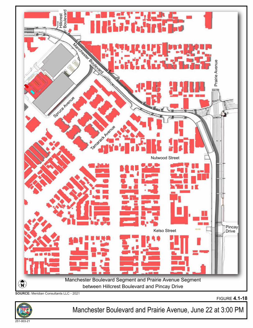
Manchester Boulevard and Prairie Avenue, June 22 at 3:00 PMFIGURE 4.1-18
251-003-21
SOURCE: Meridian Consultants LLC - 2021
Spruce
Avenu
e
Nutwood Street
Kelso Street
Manchester Boulevard
Prai
rie A
venu
e
Manchester Boulevard Segment and Prairie Avenue Segmentbetween Hillcrest Boulevard and Pincay Drive
PincayDrive
Tamara
ck Ave
nue
Hillc
rest
Boul
evar
d
N
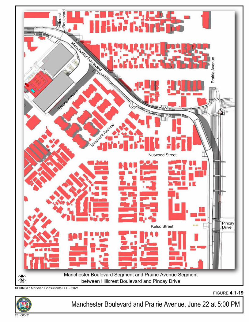
Manchester Boulevard and Prairie Avenue, June 22 at 5:00 PMFIGURE 4.1-19
251-003-21
SOURCE: Meridian Consultants LLC - 2021
Spruce
Avenu
e
Nutwood Street
Kelso Street
Manchester Boulevard
Prai
rie A
venu
e
Manchester Boulevard Segment and Prairie Avenue Segmentbetween Hillcrest Boulevard and Pincay Drive
PincayDrive
Tamara
ck Ave
nue
Hillc
rest
Boul
evar
d
N
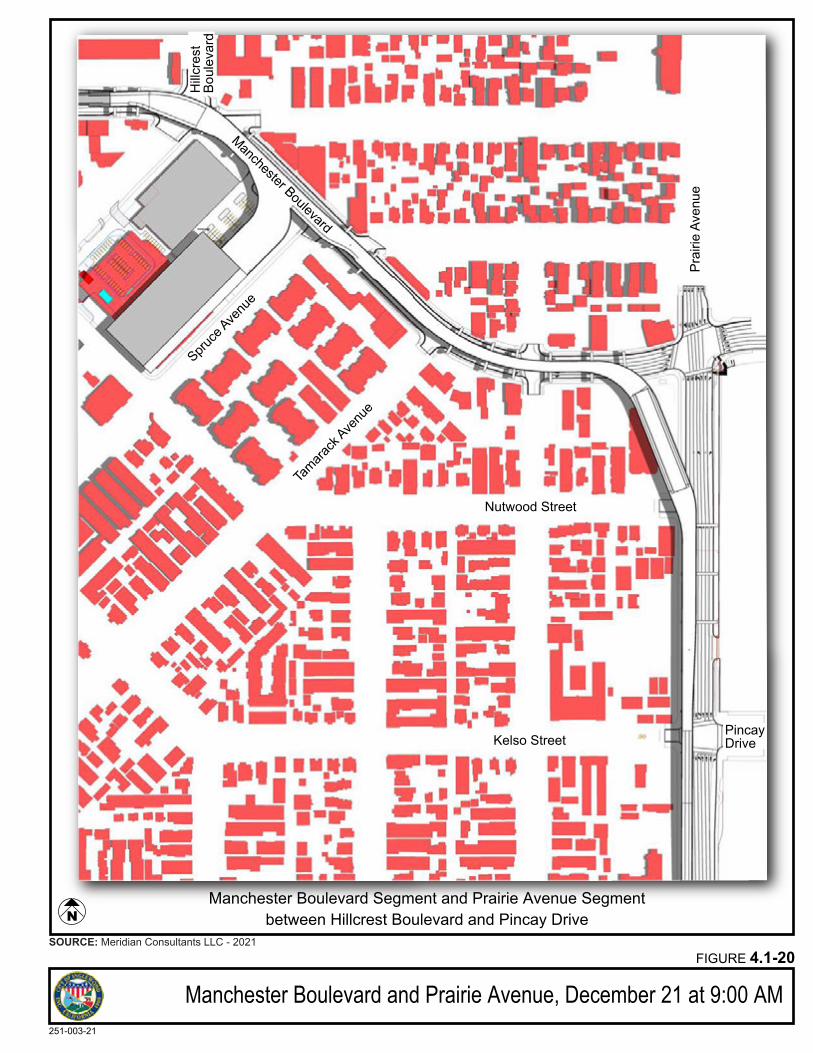
Manchester Boulevard and Prairie Avenue, December 21 at 9:00 AMFIGURE 4.1-20
251-003-21
SOURCE: Meridian Consultants LLC - 2021
Spruce
Avenu
e
Nutwood Street
Kelso Street
Manchester Boulevard
Prai
rie A
venu
e
Manchester Boulevard Segment and Prairie Avenue Segmentbetween Hillcrest Boulevard and Pincay Drive
PincayDrive
Tamara
ck Ave
nue
Hillc
rest
Boul
evar
d
N
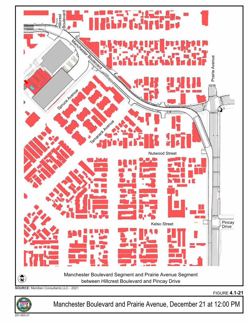
Manchester Boulevard and Prairie Avenue, December 21 at 12:00 PMFIGURE 4.1-21
251-003-21
SOURCE: Meridian Consultants LLC - 2021
Spruce
Avenu
e
Nutwood Street
Kelso Street
Manchester Boulevard
Prai
rie A
venu
e
Manchester Boulevard Segment and Prairie Avenue Segmentbetween Hillcrest Boulevard and Pincay Drive
PincayDrive
Tamara
ck Ave
nue
Hillc
rest
Boul
evar
d
N
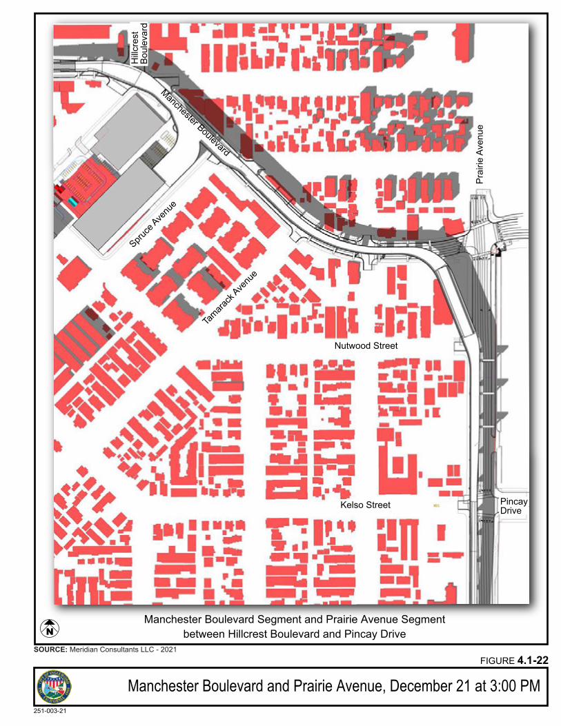
Manchester Boulevard and Prairie Avenue, December 21 at 3:00 PMFIGURE 4.1-22
251-003-21
SOURCE: Meridian Consultants LLC - 2021
Spruce
Avenu
e
Nutwood Street
Kelso Street
Manchester Boulevard
Prai
rie A
venu
e
Manchester Boulevard Segment and Prairie Avenue Segmentbetween Hillcrest Boulevard and Pincay Drive
PincayDrive
Tamara
ck Ave
nue
Hillc
rest
Boul
evar
d
N
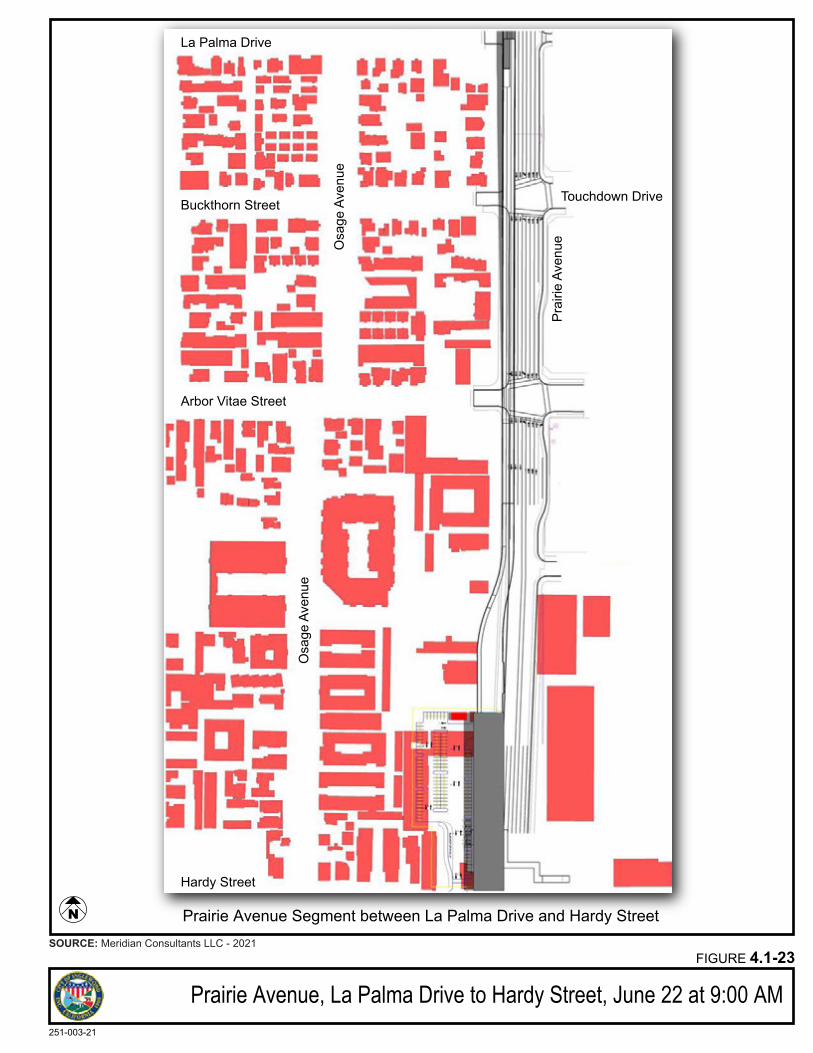
Prairie Avenue, La Palma Drive to Hardy Street, June 22 at 9:00 AMFIGURE 4.1-23
251-003-21
SOURCE: Meridian Consultants LLC - 2021
Osa
ge A
venu
e
Hardy Street
Prai
rie A
venu
e
Prairie Avenue Segment between La Palma Drive and Hardy Street
Arbor Vitae Street
Buckthorn Street
Osa
ge A
venu
e
La Palma Drive
N
Touchdown Drive

Prairie Avenue, La Palma Drive to Hardy Street, June 22 at 12:00 PMFIGURE 4.1-24
251-003-21
SOURCE: Meridian Consultants LLC - 2021
Osa
ge A
venu
e
Hardy Street
Prai
rie A
venu
e
Prairie Avenue Segment between La Palma Drive and Hardy Street
Arbor Vitae Street
Buckthorn Street
Osa
ge A
venu
e
La Palma Drive
N
Touchdown Drive
Prairie Avenue, La Palma Drive to Hardy Street, June 22 at 3:00 PMFIGURE 4.1-25
251-003-21
SOURCE: Google Earth - 2021; Meridian Consultants LLC - 2021
Osa
ge A
venu
e
Hardy Street
Prai
rie A
venu
e
Prairie Avenue Segment between La Palma Drive and Hardy Street
Arbor Vitae Street
Buckthorn Street
Osa
ge A
venu
e
La Palma Drive
N
Touchdown Drive
Prairie Avenue, La Palma Drive to Hardy Street, June 22 at 5:00 PMFIGURE 4.1-26
251-003-21
SOURCE: Google Earth - 2021; Meridian Consultants LLC - 2021
Osa
ge A
venu
e
Hardy Street
Prai
rie A
venu
e
Prairie Avenue Segment between La Palma Drive and Hardy Street
Arbor Vitae Street
Buckthorn Street
Osa
ge A
venu
e
La Palma Drive
N
Touchdown Drive
Prairie Avenue, La Palma Drive to Hardy Street, December 21 at 9:00 AMFIGURE 4.1-27
251-003-21
SOURCE: Google Earth - 2021; Meridian Consultants LLC - 2021
Osa
ge A
venu
e
Hardy Street
Prai
rie A
venu
e
Prairie Avenue Segment between La Palma Drive and Hardy Street
Arbor Vitae Street
Buckthorn Street
Osa
ge A
venu
e
La Palma Drive
N
Touchdown Drive
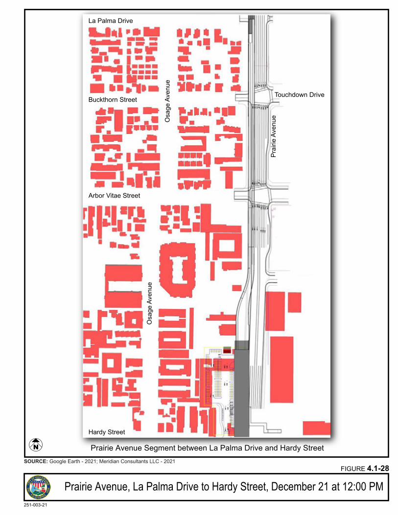
Prairie Avenue, La Palma Drive to Hardy Street, December 21 at 12:00 PMFIGURE 4.1-28
251-003-21
SOURCE: Google Earth - 2021; Meridian Consultants LLC - 2021
Osa
ge A
venu
e
Hardy Street
Prai
rie A
venu
e
Prairie Avenue Segment between La Palma Drive and Hardy Street
Arbor Vitae Street
Buckthorn Street
Osa
ge A
venu
e
La Palma Drive
N
Touchdown Drive
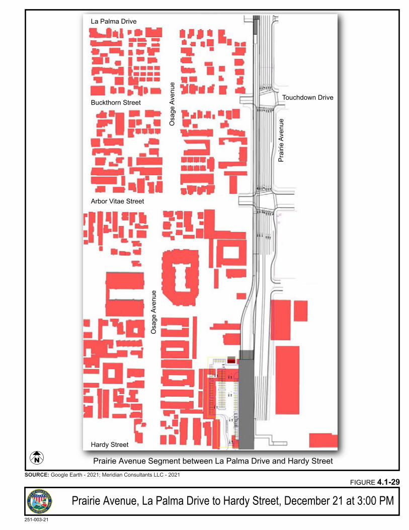
Prairie Avenue, La Palma Drive to Hardy Street, December 21 at 3:00 PMFIGURE 4.1-29
251-003-21
SOURCE: Google Earth - 2021; Meridian Consultants LLC - 2021
Osa
ge A
venu
e
Hardy Street
Prai
rie A
venu
e
Prairie Avenue Segment between La Palma Drive and Hardy Street
Arbor Vitae Street
Buckthorn Street
Osa
ge A
venu
e
La Palma Drive
N
Touchdown Drive
Meridian Consultants 4.1-67 Inglewood Transit Connector Project 208-001-18 November 2021
As the shadow of the guideway would not affect any specific location for an extended time due to its size
and location, the proposed Project would have a less than significant shade and shadow impact on the
surrounding uses in this segment.
The addition of the components of the ITC Project including stations, elevated passenger walkways, ATS
guideway along the proposed alignment along Market Street, Manchester Boulevard and Prairie Avenue
and the proposed street improvements, including the shift of one of the existing travel lanes on Prairie
Avenue up to thirty (30) feet into the existing setback area, the construction of the new Vons store on the
corner of Manchester Boulevard and Hillcrest Boulevard, will not result in substantial adverse change of
the existing visual character of the surrounding developed urban area.
Mitigation Measures
No mitigation is required.
Level of Significance
While the proposed Project, inclusive of the ATS guideway, stations, MSF, PDS substations, street
improvements, and the new Vons store would result in changes to the existing visual character of the areas
located along the proposed alignment of the ATS system, the Project would not result in substantial
adverse changes to the existing visual character of these street corridors due to the design character of
the Project as defined in the Design Standards and Guidelines and the project design features, which would
result in the integration of the components of the Project into these street corridors.
Visual impacts associated with construction of the proposed Project would be less than significant with
the implementation of measures from the CCP. These CCP measures would reduce the visual duration of
the obtrusive erosion control devices to as short of a duration as feasible. The stockpile areas would be
limited to areas less visibly sensitive as approved by the City. These measures would minimize the visual
degradation impacts of the construction activities. The construction activities would also be phased to
limit the exposure of one segment from continual exposure to construction activities and unpleasant
views. Construction activities at each segment and overall would be temporary in nature and visual
impacts would be alleviated once the construction is completed.
Overall, the ATS structure, including the stations, guideway, MSF, and support facilities, would complement
the existing surrounding visual environment by using transparent and neutral tones as part of its design
character. The design would be in the modernist style to enhance the aesthetically pleasing quality of the
structure. To prevent unsightly views and defacing of the structure, the exterior material would be anti-
graffiti and anti-vandalism. The final design of the stations would also reflect the visual character of
Downtown Inglewood along Market Street and the new development occurring along Prairie Avenue.
Meridian Consultants 4.1-68 Inglewood Transit Connector Project 208-001-18 November 2021
The design of the ATS guideway would allow the continued expression of the buildings identified as historic
resources. The height of the ATS guideway, the distance of the guideway from the edge of the buildings
and the size and spacing of the support columns have been designed in a manner that maintains important
aspects of the existing setting for the historic resources located along the proposed alignment and ensures
that the overall scale, massing, composition and design of these historic buildings would remain readily
visible despite some interruption of views. The ability of the buildings to convey their historic significance
would not be substantially impaired by the proposed Project. Therefore, indirect impacts to identified
historic resources would be less than significant.
Impact AES-1 b: If the project is in an urbanized area, would the project be consistent with applicable zoning and planning regulations governing scenic quality?
As previously noted, the proposed Project is located entirely within a developed urban area containing
commercial, residential, and industrial uses near major corridors.
City General Plan
The City’s General Plan includes the Land Use Element which identifies various goals and policies that
indirectly address the City’s aesthetic objectives. The Land Use Element includes the following applicable
goals:
Goal 1: Promote Inglewood’s image and identity as an independent community within
the Los Angeles metropolitan area.
Goal 2: Improve the visual appearance and economic condition of the existing arterial
commercial development along Inglewood’s major streets.
The Downtown TOD Plan in the Land Use Element contains the following goals:
Goal 1: Downtown is a place to live, work, shop, recreate, and be entertained.
Goal 2: Downtown is a revitalized yet forward-looking gathering place for the community.
Goal 6: Downtown expresses the unique culture of Inglewood.
The proposed Project would be consistent with the General Plan goals and policies by improving the
general visual appearance of Inglewood through the incorporation of aesthetically pleasing architectural
designs in the modern style for the guideway and stations. The structures of the ATS system, including the
stations, guideway, MSF, and support facilities, would utilize transparent material where feasible and
appropriate and neutral tones to better integrate the system into the existing surrounding community.
Meridian Consultants 4.1-69 Inglewood Transit Connector Project 208-001-18 November 2021
Unique Inglewood Historic Core elements may be incorporated to the extent provided for in the ITC Design
Standards and Guidelines to further Downtown Inglewood’s expression of a unique culture. To ensure the
consistency of the ATS system with the historic fabric of downtown and the General Plan Land Use Element
the proposed amendment is included as part of the Project:
The new text shown as underlined is proposed to be added to the goal below in the “Circulation”
subsection of the “Goals and Objectives” section:
− Policy 2.3: Preservation of Historic Fabric. Require the preservation of buildings that have been designated as historic and encourage the reuse of other historic buildings. Maintain the sense of place in areas with historic fabric and/or meaning such as Market Street between Regent Street and Hillcrest Avenue and the Hillcrest neighborhood east of Locust Street, while also accommodating for the development of the Inglewood Transit Connector along Market Street between Regent Street and Manchester Boulevard.
The incorporation of the underlined language would allow for the implementation of the proposed Project
to be consistent with the existing General Plan.
For detailed consistency analysis of the Land Use goals and policies please see Table 4.1-2: Scenic Quality
Consistency with General Plan Land Use Element.
Table 4.1-2 Scenic Quality Consistency with General Plan Land Use Element
Goals and Policies Project Consistency
Goals and Policies added with 2016 Amendment
Goal 1: Downtown is a place to live, work, shop, recreate, and be entertained.
Consistent. The proposed Project would strengthen Downtown Inglewood for commercial and residential uses by increasing accessibility to the downtown from local activity centers and the regional light rail network. This increased transit accessibility would promote local economic development opportunities, and enhance Downtown’s retail, recreation, and entertainment offerings and range of housing and employment options. Implementation of the proposed Project would activate and complement development in the City, and enhance social cohesion, equity, and community resilience. The streetscape improvements proposed as part of the Project will improve the pedestrian character of Market Street in Downtown.
Goal 2: Downtown is a revitalized yet forward-looking gathering place for the community.
Consistent. The proposed Project would promote economic development opportunities in Downtown Inglewood and support the development of a revitalized Downtown that serves as a gathering place for residents and visitors by increasing transit accessibility.
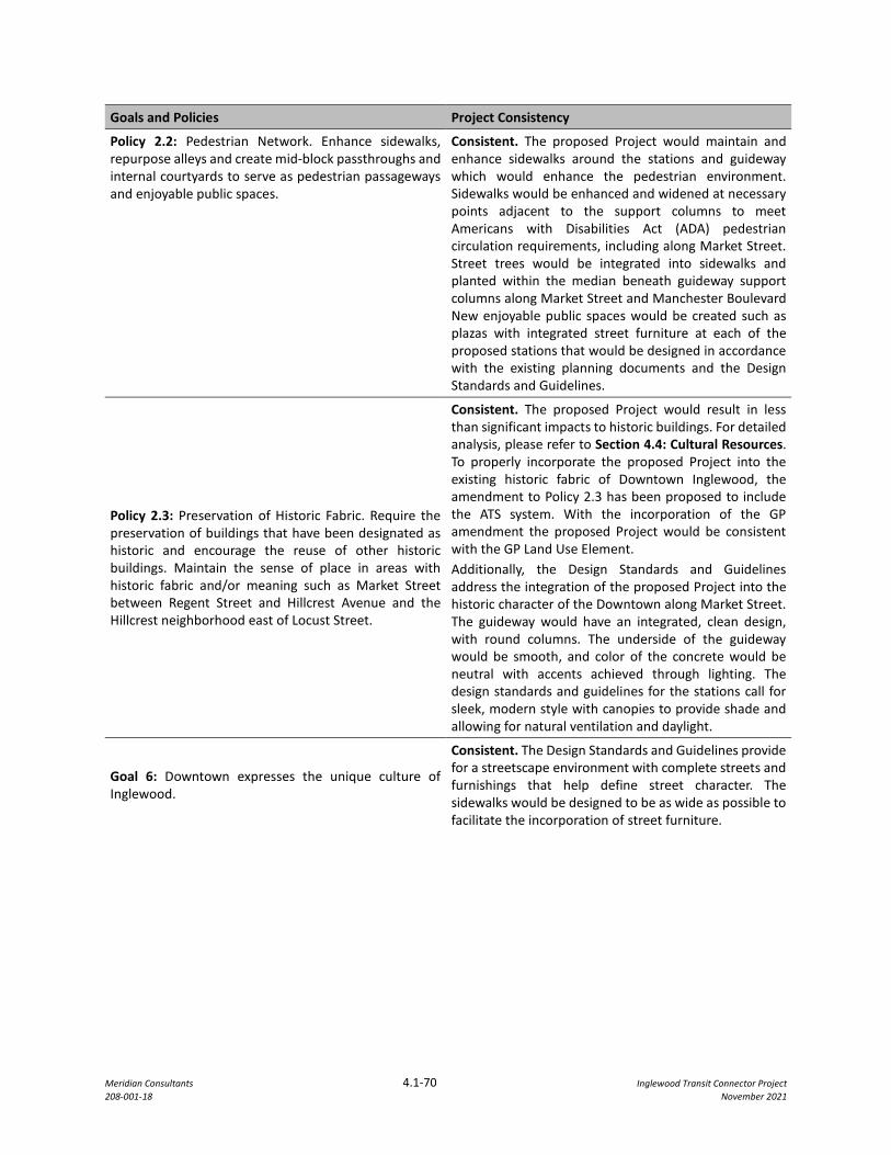
Meridian Consultants 4.1-70 Inglewood Transit Connector Project 208-001-18 November 2021
Goals and Policies Project Consistency
Policy 2.2: Pedestrian Network. Enhance sidewalks, repurpose alleys and create mid-block passthroughs and internal courtyards to serve as pedestrian passageways and enjoyable public spaces.
Consistent. The proposed Project would maintain and enhance sidewalks around the stations and guideway which would enhance the pedestrian environment. Sidewalks would be enhanced and widened at necessary points adjacent to the support columns to meet Americans with Disabilities Act (ADA) pedestrian circulation requirements, including along Market Street. Street trees would be integrated into sidewalks and planted within the median beneath guideway support columns along Market Street and Manchester Boulevard New enjoyable public spaces would be created such as plazas with integrated street furniture at each of the proposed stations that would be designed in accordance with the existing planning documents and the Design Standards and Guidelines.
Policy 2.3: Preservation of Historic Fabric. Require the preservation of buildings that have been designated as historic and encourage the reuse of other historic buildings. Maintain the sense of place in areas with historic fabric and/or meaning such as Market Street between Regent Street and Hillcrest Avenue and the Hillcrest neighborhood east of Locust Street.
Consistent. The proposed Project would result in less than significant impacts to historic buildings. For detailed analysis, please refer to Section 4.4: Cultural Resources. To properly incorporate the proposed Project into the existing historic fabric of Downtown Inglewood, the amendment to Policy 2.3 has been proposed to include the ATS system. With the incorporation of the GP amendment the proposed Project would be consistent with the GP Land Use Element. Additionally, the Design Standards and Guidelines address the integration of the proposed Project into the historic character of the Downtown along Market Street. The guideway would have an integrated, clean design, with round columns. The underside of the guideway would be smooth, and color of the concrete would be neutral with accents achieved through lighting. The design standards and guidelines for the stations call for sleek, modern style with canopies to provide shade and allowing for natural ventilation and daylight.
Goal 6: Downtown expresses the unique culture of Inglewood.
Consistent. The Design Standards and Guidelines provide for a streetscape environment with complete streets and furnishings that help define street character. The sidewalks would be designed to be as wide as possible to facilitate the incorporation of street furniture.
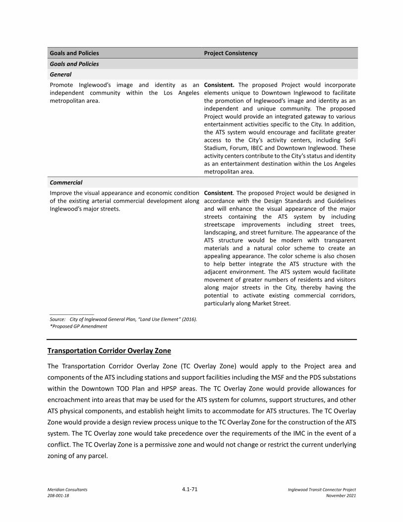
Meridian Consultants 4.1-71 Inglewood Transit Connector Project 208-001-18 November 2021
Goals and Policies Project Consistency
Goals and Policies
General
Promote Inglewood’s image and identity as an independent community within the Los Angeles metropolitan area.
Consistent. The proposed Project would incorporate elements unique to Downtown Inglewood to facilitate the promotion of Inglewood’s image and identity as an independent and unique community. The proposed Project would provide an integrated gateway to various entertainment activities specific to the City. In addition, the ATS system would encourage and facilitate greater access to the City’s activity centers, including SoFi Stadium, Forum, IBEC and Downtown Inglewood. These activity centers contribute to the City’s status and identity as an entertainment destination within the Los Angeles metropolitan area.
Commercial
Improve the visual appearance and economic condition of the existing arterial commercial development along Inglewood’s major streets.
Consistent. The proposed Project would be designed in accordance with the Design Standards and Guidelines and will enhance the visual appearance of the major streets containing the ATS system by including streetscape improvements including street trees, landscaping, and street furniture. The appearance of the ATS structure would be modern with transparent materials and a natural color scheme to create an appealing appearance. The color scheme is also chosen to help better integrate the ATS structure with the adjacent environment. The ATS system would facilitate movement of greater numbers of residents and visitors along major streets in the City, thereby having the potential to activate existing commercial corridors, particularly along Market Street.
_________________ Source: City of Inglewood General Plan, “Land Use Element” (2016). *Proposed GP Amendment
Transportation Corridor Overlay Zone
The Transportation Corridor Overlay Zone (TC Overlay Zone) would apply to the Project area and components of the ATS including stations and support facilities including the MSF and the PDS substations within the Downtown TOD Plan and HPSP areas. The TC Overlay Zone would provide allowances for encroachment into areas that may be used for the ATS system for columns, support structures, and other ATS physical components, and establish height limits to accommodate for ATS structures. The TC Overlay Zone would provide a design review process unique to the TC Overlay Zone for the construction of the ATS system. The TC Overlay zone would take precedence over the requirements of the IMC in the event of a conflict. The TC Overlay Zone is a permissive zone and would not change or restrict the current underlying zoning of any parcel.
Meridian Consultants 4.1-72 Inglewood Transit Connector Project 208-001-18 November 2021
With the implementation of the TC Overlay zone, implementation of the ATS system would be consistent with the IMC and other local regulations.
Downtown TOD Plan and Design Guidelines
Portions of the proposed Project are located in the Historic Core area designated by the Downtown TOD Plan. While the ITC Design Standards and Guidelines address the Project and will not alter or change the standards in the Downtown TOD Plan, the Design Standards and Guidelines were created to integrate all Project elements with the Historic Core area vision set forth in the Downtown TOD Plan. Additionally, the Design Standards and Guidelines require consideration of the Downtown TOD Plan guidelines during the refinement of the design of the Project.
The Project would be designed in accordance with the Design Standards and Guidelines and would help fulfill the relevant aesthetic goals and policies of the Downtown TOD Plan, as outlined in Table 4.1-2. For analysis of goals and policies relevant to land use plans and planning, please refer to Section 4.9: Land Use and Planning. As discussed above, the Downtown TOD Plan area includes the entire Market Street segment and a portion of the Manchester Boulevard segment from Market Street to Locust Street. Accordingly, streetscape design and street trees in these areas would complement the guidelines defined within the Downtown TOD Plan. Section 4.10 of the Downtown TOD Plan details the visual design guidelines for Historic Downtown which would be integrated into the design considerations of the proposed Project.
With the incorporation of the General Plan amendment described above, the required consideration of the Downtown TOD Plan guidelines into the ITC Design Standards and Guidelines, and the complementary design and modern style of the ATS system, the proposed Project would be consistent with the Downtown TOD Plan and Guidelines.
Hollywood Park Specific Plan
The Design Standards and Guidelines, and resulting design of the proposed Project, would not obstruct the implementation of the HPSP policies related to visual character as shown in Table 4.1-3: ITC Design Standards and Guidelines Consistency with the Hollywood Park Specific Plan below. The HPSP includes visual guidelines and standards for the public right-of-way within the plan area, which includes areas north of Hardy Street along Prairie Avenue. The HPSP also provides integrated and coordinated landscape design guidelines for new development in areas subject to HPSP’s Plot Plan Review process along the perimeter of the Plan area with the objective of promoting visual compatibility. Similar to the Design Standards and Guidelines’ approach to the portions of the Project located in the Downtown TOD Plan area, while the Design Standards and Guidelines will govern construction of the Project and therefore control over any conflicting provisions contained in HPSP, the Design Standards and Guidelines were created to integrate the Project elements with the HPSP streetscape. Additionally, the Design Standards and Guidelines require consideration of the HPSP’s design guidelines where applicable during the refinement of Project plans.
Meridian Consultants 4.1-73 Inglewood Transit Connector Project 208-001-18 November 2021
The foregoing will apply to the portions of the proposed Project adjacent to the HPSP area that are covered by the HPSP’s Plot Plan Review process, including the portions of the ATS guideway, the Prairie Avenue/Hardy Street station, and various support structures and columns.
The Project also includes a proposed amendment to the HPSP to address any potential conflict or inconsistency with the HPSP that may result from the shift of one lane of Prairie Avenue thirty (30) feet into the existing setback area on the east side of Prairie Avenue in the HPSP area and the associated reconfiguration of the existing sidewalk, landscape and other improvements that would be affected. For example, the amendment would eliminate the requirement for a 30-foot setback along the western edge of the HPSP to allow zero-lot line development. Accordingly, future buildings and structures within the HPSP area adjacent to Prairie Avenue would be permitted to be built along the existing property line without requiring any additional setback along Prairie Avenue. The landscape area within the 30-foot setback area on Prairie Avenue along the western edge of the HPSP area will be reduced or eliminated in certain areas, as needed to accommodate the new street easement. With this amendment and the replacement of existing streetscape features and signs that will be affected by street improvements to Prairie Avenue, no significant effects on the visual character of the HPSP area as defined by the HPSP will result from the Project.
Inglewood Municipal Code
For the portions of the ATS systems that are not in the Downtown TOD or the Hollywood Park Specific Plan, the ITC Design Standards and Guidelines would prevail over the IMC, though IMC provisions relating to streetscapes, landscapes and signage are incorporated as part of the design process.
Tree Preservation
The IMC Tree Preservation ordinance30 recognizes the importance of both native and nonnative trees within the City for the many benefits they provide. Prior to removing or cutting a protected tree in the City, a permit must be obtained with the City’s Parks, Recreation, and Library Services Department. All trees removed require replacement with like-size, like-kind trees or an equal value tree or trees as determined by the City’s Mater Plan or the Parks, Recreation, and Library Services Department. Compliance with the IMC Section 12-110, Tree Preservation requirements would ensure consistency and compliance of the proposed Project to the existing policies and guidelines.
Additionally, the PDF AES-2 is consistent with the tree replacement ordinance in the IMC and also requires avoidance of tree removal to the extent feasible along with additional measures pursuant to the CCP. Any and all trees removed would be replace in kind and the same location if at all possible and in a timely manner, if the replacement of the tree would not conflict with future construction activities of the proposed Project.
30 Inglewood, California, Municipal Code, Article 32, Section 12-110 (2012), Tree Preservation.
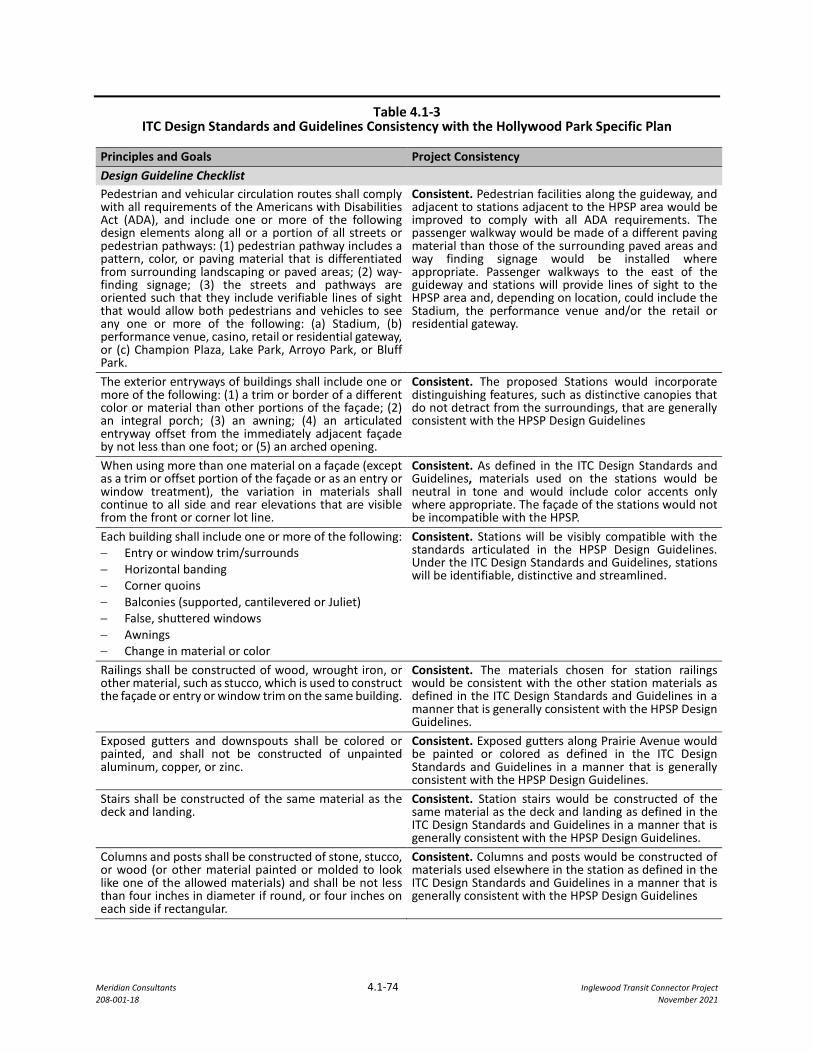
Meridian Consultants 4.1-74 Inglewood Transit Connector Project 208-001-18 November 2021
Table 4.1-3 ITC Design Standards and Guidelines Consistency with the Hollywood Park Specific Plan
Principles and Goals Project Consistency Design Guideline Checklist Pedestrian and vehicular circulation routes shall comply with all requirements of the Americans with Disabilities Act (ADA), and include one or more of the following design elements along all or a portion of all streets or pedestrian pathways: (1) pedestrian pathway includes a pattern, color, or paving material that is differentiated from surrounding landscaping or paved areas; (2) way-finding signage; (3) the streets and pathways are oriented such that they include verifiable lines of sight that would allow both pedestrians and vehicles to see any one or more of the following: (a) Stadium, (b) performance venue, casino, retail or residential gateway, or (c) Champion Plaza, Lake Park, Arroyo Park, or Bluff Park.
Consistent. Pedestrian facilities along the guideway, and adjacent to stations adjacent to the HPSP area would be improved to comply with all ADA requirements. The passenger walkway would be made of a different paving material than those of the surrounding paved areas and way finding signage would be installed where appropriate. Passenger walkways to the east of the guideway and stations will provide lines of sight to the HPSP area and, depending on location, could include the Stadium, the performance venue and/or the retail or residential gateway.
The exterior entryways of buildings shall include one or more of the following: (1) a trim or border of a different color or material than other portions of the façade; (2) an integral porch; (3) an awning; (4) an articulated entryway offset from the immediately adjacent façade by not less than one foot; or (5) an arched opening.
Consistent. The proposed Stations would incorporate distinguishing features, such as distinctive canopies that do not detract from the surroundings, that are generally consistent with the HPSP Design Guidelines
When using more than one material on a façade (except as a trim or offset portion of the façade or as an entry or window treatment), the variation in materials shall continue to all side and rear elevations that are visible from the front or corner lot line.
Consistent. As defined in the ITC Design Standards and Guidelines, materials used on the stations would be neutral in tone and would include color accents only where appropriate. The façade of the stations would not be incompatible with the HPSP.
Each building shall include one or more of the following: − Entry or window trim/surrounds − Horizontal banding − Corner quoins − Balconies (supported, cantilevered or Juliet) − False, shuttered windows − Awnings − Change in material or color
Consistent. Stations will be visibly compatible with the standards articulated in the HPSP Design Guidelines. Under the ITC Design Standards and Guidelines, stations will be identifiable, distinctive and streamlined.
Railings shall be constructed of wood, wrought iron, or other material, such as stucco, which is used to construct the façade or entry or window trim on the same building.
Consistent. The materials chosen for station railings would be consistent with the other station materials as defined in the ITC Design Standards and Guidelines in a manner that is generally consistent with the HPSP Design Guidelines.
Exposed gutters and downspouts shall be colored or painted, and shall not be constructed of unpainted aluminum, copper, or zinc.
Consistent. Exposed gutters along Prairie Avenue would be painted or colored as defined in the ITC Design Standards and Guidelines in a manner that is generally consistent with the HPSP Design Guidelines.
Stairs shall be constructed of the same material as the deck and landing.
Consistent. Station stairs would be constructed of the same material as the deck and landing as defined in the ITC Design Standards and Guidelines in a manner that is generally consistent with the HPSP Design Guidelines.
Columns and posts shall be constructed of stone, stucco, or wood (or other material painted or molded to look like one of the allowed materials) and shall be not less than four inches in diameter if round, or four inches on each side if rectangular.
Consistent. Columns and posts would be constructed of materials used elsewhere in the station as defined in the ITC Design Standards and Guidelines in a manner that is generally consistent with the HPSP Design Guidelines
Meridian Consultants 4.1-75 Inglewood Transit Connector Project 208-001-18 November 2021
PDF AES-2also requires the Contractor to maintain any replacement trees for three years after the date of planting and provide a warranty for such trees for at least one additional year post maintenance. The contractor and the City would conduct an inspection of all replaced trees before the one-year warranty expires before the City accepts the tree. These requirements as described in PDF AES-2 would further the goal of the City to protect and maintain City trees within its jurisdiction.
Design Review Process
The Public Works Director or his/her designee would, in consultation with the Planning Division Manager or his/her designee, have the authority to review each ITC system project for compliance with all applicable provisions of (i) the ITC Design Standards and Guidelines, (ii) all additional technical, aesthetic, and other specifications contained in the procurement document(s) for the applicable ITC system component(s), and (iii) all requirements of the Mitigation Monitoring and Reporting Program set forth in the ITC’s Final Environmental Impact Report.
The Director of Public Works or her/his designee would in consultation with the Planning Division Manager or her/his designee have the ability to update and/or revise the ITC Design Standards and Guidelines from time to time to include, among other things, alternate technologies, new or updated ITC Design Standards and Guidelines, consistency determinations of ITC procurement document(s) and alternative mitigation measures that achieve a comparable level of mitigation and/or, clarifications of existing provisions. The Director of Public Works or her/his designee would have the final decision-making authority regarding the interpretation of the Design Guidelines should there be an appeal ability to Council. This design process is consistent with the IMC.
Summary
As described previously, the proposed Project would take into consideration and be consistent with visual and materials-related guidelines from plans governing adjacent areas in the Downtown TOD Plan and the HPSP areas, to the extent feasible and consistent with the Design Guidelines. An amendment to Policy 2.3 of the General Plan Land Use Element has been introduced to ensure consistency of the proposed Project with the City’s General Plan. The amendment describes the incorporation and implementation of the ATS system into the historic fabric of the Inglewood historic core.
The TC Overlay Zone would also be implemented to accommodate for the ATS system and its related elements in the City. The introduction of the TC Overlay Zone would reduce the potential for the proposed Project to conflict with the IMC since the TC Overlay Zone implements the Design Guidelines and applies them to the construction of the ATS system and related components within the TC Overlay Zone. The TC Overlay Zone will not have any impacts on other, non-Project elements that fall within the TC Overlay Zone,
Meridian Consultants 4.1-76 Inglewood Transit Connector Project 208-001-18 November 2021
as those uses would continue to be governed by their existing, underlying zone and other provisions of the IMC.
With the implementation of the TC Overlay Zone and the amendment to the City’s General Plan, the proposed Project would be generally consistent with existing zoning and planning regulations governing scenic quality. Therefore, impacts would be less than significant.
Mitigation Measures
No mitigation is required.
Level of Significance
The impacts associated with applicable zoning and planning regulations governing scenic quality would be less than significant.
Impact AES-2: Would the project create a new source of substantial light or glare which would adversely affect day or nighttime views in the area?
Construction
Under existing conditions, the area surrounding the proposed Project has a relatively high level of ambient lighting, particularly along Florence Avenue, Manchester Boulevard, and Prairie Avenue, as those streets are well-lit, active transportation corridors. Nighttime construction activities would add to the existing ambient light levels on and in the area surrounding the proposed Project for the duration of construction.
Over the course of the construction of the proposed Project, the length of workdays would vary with the level of activity fluctuating throughout any given day. This would influence the nighttime work hours in a day which would influence the amount of lighting required at a site for a given day. The daily duration of nighttime construction lighting would also vary based on the season, with the longest duration of construction lighting occurring during winter months, when there are fewer hours of daylight, and the shortest duration of construction lighting during the summer months, when there are the most hours of daylight. Nighttime lighting sources during construction would consist mainly of floodlights that would be focused on the work area. Security lighting could also be used on construction sites but would be focused on the Project alignment. Because this lighting is intended to light the Project alignment to allow for nighttime construction and to provide security to the site, it would tend to be directed away from nearby adjacent properties, reducing the potential for spillover lighting effects.
Nighttime construction lighting would be temporary in nature. The CCP outlines measures to be taken to limit nighttime light spillage and glare to adjacent uses. Prior to the start of construction, light plans and mitigation measures would be drafted in accordance with the standards for the City issued Construction
Meridian Consultants 4.1-77 Inglewood Transit Connector Project 208-001-18 November 2021
Permit. Temporary lighting at construction sites would be limited to the amount necessary to safely perform the required work and would be directed downwards and shielded to avoid light spillage. Placement and orientation of the portable lighting fixtures would be placed in a manner to avoid directing lights toward sensitive receptors, including vehicle drivers on the roadway. The placement, shielding, and direction of the lighting would be purposeful and reduce the illumination outside of the intended area to the extent possible. The limited time duration of lighting would also limit the amount of illumination impact on nearby uses to the extend feasible.
In the event where lighting is required near the edge of the construction area, light trespass shall not exceed one foot-candle above ambient light level as measured at any adjacent residential and transient properties as outlined in the CCP. This measure would ensure lighting does not extend outside of the limits of the construction site in any significant manner. To ensure safety, temporary sidewalks, and any sidewalk adjacent to construction activities would be illuminated to City Standards to protect public safety. The illumination would be equivalent to those of street lighting and would not significantly contribute to visual impacts through significant light spillage or glare.
In addition to minimizing light spill, the CCP would ensure sensitive receptors and motorists on public streets would not have direct views of construction light sources to limit potential effects of glare. Sound barriers and temporary construction barriers that would be built in the initial phase of project construction, and, as construction progresses, newly constructed intervening structures would also incrementally block light and obscure views of construction sites from nearby residences and local streets, further restricting the potential for spillover lighting as construction progresses.
Any nighttime construction activities would require a permit from the Permits and License Committee of the City. The proposed Project would comply with any conditions identified by the City to reduce nighttime construction lighting.
With the incorporation of the CCP measures the potential impact for construction lighting and glare on surrounding land uses and sensitive receptors would be reduced to the extent feasible. Lighting and glare impacts during construction would be less than significant.
Operation
Market Street Segment
The Market Street segment contains existing ambient lighting conditions typical for a highly developed urban setting. Sources of existing light in this segment include streetlights, vehicle headlights, traffic lights, and lighting from parking lots, offices, and storefronts. As described under existing conditions, there are no existing light sensitive uses on Market Street such as residential dwelling and hotels/motels. Existing sources of daytime and nighttime glare in the area include mostly headlights of traveling cars in the area.
Meridian Consultants 4.1-78 Inglewood Transit Connector Project 208-001-18 November 2021
PDF AES-3 includes the lighting design standards in the Design Guidelines. These guidelines address lighting for station design, guideway and support structures, the MSF, and elevated passenger walkways as described below.
Market Street/Florence Avenue Station
The station would be located on a site at 300 Florence Avenue currently developed with a retail commercial center. Lighting at the station would include accent lighting, lighting for security placed on pedestrian paths, and interior lighting within the station. Canopy lighting at the station would utilize indirect accent lighting to avoid glare and light illumination on adjacent properties. Additional accent lighting at the station would be less prominent than the accent lighting on the canopy and be of lesser visual impact to surrounding uses. Pedestrian friendly lighting would be functional and placed in a manner to minimize negative impacts on adjacent property. Care in the placement of the lighting would further reduce light spillage and glare to nearby uses. Additionally, all lighting facilities at the station would be programmable and sensor controlled to conserve energy and allow control for various settings such as daytime, nighttime, and event lighting. These settings would further ensure lighting at the property would be actively controlled and contained, and the level of lighting would be appropriate for the time of the day or events held at the City as required by PDF AES-3. The station would occupy a site already illuminated by nighttime lighting; the impact of the station lighting would be less than significant.
ATS Guideway
The ATS Guideway may include lighting fixtures for accent lighting. The light fixtures would be concealed or minimally visible within the guideway structure by design. Care would be taken to place lighting in a manner to limit the illumination impact on adjacent properties and lighting would not be visible from the ground level per the Design Guidelines. The limited visibility of the lighting and lighting fixture would reduce the chance of glare to passersby and adjacent uses. Illumination of the surrounding uses would also be limited by the reduced visibility of the light source. The guideway material used would be non-glare to eliminate potential for introducing glare to the surrounding uses. Because of the manner in which the lighting and the light fixtures would be designed as required by PDF AES-3, and the use of non-glare materials, lighting, and glare impacts of the ATS Guideway would be less than significant to surrounding uses and passersby.
Surface Parking Lots
Surface parking lots in the Market Street segment would be provided at the Market Street/Florence Avenue Station and at the existing site. Functional security lighting for the sites would be provided to ensure safety of the lots. Street trees surrounding the parking lot would be provided for aesthetic purposes separating the parking stalls from sidewalks which would also limit light spillage to adjacent areas outside
Meridian Consultants 4.1-79 Inglewood Transit Connector Project 208-001-18 November 2021
of the parking lots and limit glare. All parking lots are located at sites with existing light sources such as streetlights and interior lighting from buildings. As such, the security lighting at surface parking lots would not have a significant impact on surrounding uses beyond the existing light sources. The light and glare impact of surface parking lot lighting would be less than significant.
Streetscape
Roadway lighting would follow the requirements of the City of Inglewood per the Design Guidelines and would, therefore, be comparable to existing lighting on the roadway and not contribute to additional light spillage or glare. Pedestrian lighting in this segment would be provided on sidewalks, in elevated passenger walkways, at public places, and in all pedestrian pathways under ATS guideway to ensure safety and security for pedestrians. Along primary circulation routes, light fixtures and incident light sources would provide an average of 3-foot candles to help pedestrians better distinguish color, size, and shape of their surroundings. The streetscape lighting would not significantly contribute to existing lighting at the Project area where existing lighting as described above is consistent with the level of lighting at a highly developed urban area. Therefore, lighting and glare impacts of roadway and street lighting in this segment would be less than significant.
Manchester Boulevard Segment
The Manchester Boulevard segment contains existing ambient lighting characteristic typical for a highly developed urban setting. Sources of existing light in this segment includes streetlights, vehicle headlights, traffic lights, and lighting from parking lots, offices, storefronts, and interior illumination from residences.
ATS Guideway
Similar to the Market Street segment, the ATS guideway may include accent lighting along the guideway. Care would be taken to place accent and functional lighting in a manner to limit the illumination impact on adjacent properties and lighting would not be visible from the ground level per the Design Guidelines. The limited visibility of the lighting and lighting fixtures would reduce the chance of glare to passersby and adjacent uses. Illumination of the surrounding uses would also be limited by the reduced visibility of the light source. The guideway material would be non-glare to eliminate potential for introducing glare to the surrounding uses.
Light sensitive receptors along this segment consist of the homes located on the north side of Manchester Boulevard between Manchester Drive and Osage Avenue. In addition to the design measures mentioned previously to avoid light spillage and glare to nearby uses, the guideway along the segment with residential uses would be positioned towards the south side of the guideway. The positioning of the guideway would allow approximately 30 feet between the closest residential buildings and the edge of the guideway. The
Meridian Consultants 4.1-80 Inglewood Transit Connector Project 208-001-18 November 2021
elevated guideway would also be substantially above the height of the residential home and the lighting would not be in direct line of sight of the residents at the ground level.
Overall, because of the manner in which the lighting and the light fixture would be designed, the non-glare exterior material of the guideway as required by PDF AES-3, and the positioning and height of the guideway, lighting, and glare impacts of the ATS Guideway on surrounding uses and sensitive receptors would be less than significant.
Maintenance Storage Facility
The MSF would be built on a site currently developed with a retail commercial center. Lighting would be provided and placed in a manner to limit light spillage and glare on the residential uses across Spruce Avenue from the proposed MSF site. The building entrances to the MSF site would be lit to maintain safety and security of workers and passersby and primary walkways, steps, or ramps along the pedestrian routes would also be illuminated per PDF AES-3 and ITC Design Standards and Guidelines. Security lighting in the parking lot would also be installed to maintain the safety of staffs and visitors.
The MSF would be separated from adjacent uses by the public right of way where existing sources of ambient light and glare includes vehicles, streetlights, and light sources from the interior of other adjacent buildings, including the new Vons store located on the northwest portion of the site. Lighting used by the MSF is would not result in any substantial increase in the level of the existing lighting by surrounding uses. Additionally, street trees would surround the MSF site for aesthetic appeal on the sidewalks and would further obstruct the lighting associated with the MSF. Therefore, lighting and glare impacts from the MSF site on surrounding uses would be less than significant.
Streetscape
Similar to the Market Street segment, roadway lighting would follow the requirements of the City of Inglewood per the Design Guidelines and would, therefore, be comparable to existing lighting on the roadway and not contribute to additional light spillage or glare. Pedestrian lighting in this segment would be provided similarly to the Market Street segment with the same guidelines and design features. Therefore, lighting and glare impacts of roadway and street lighting in this segment would be less than significant.
Prairie Avenue Segment
The Prairie Avenue segment contains existing ambient lighting characteristic typical for a highly developed urban setting. Sources of existing light in this segment includes streetlights, vehicle headlights, traffic lights, and lighting from parking lots, offices, billboards, and storefronts, security lighting at construction sites, and interior illumination from residences and hotels.
Meridian Consultants 4.1-81 Inglewood Transit Connector Project 208-001-18 November 2021
Manchester Boulevard/Prairie Avenue Station and Prairie Avenue/Hardy Street Station
Similar to the Market Street/Florence Avenue station, lighting at the stations would include accent lighting, lighting for security placed on pedestrian paths, and interior lighting within the station. Canopy lighting at the station utilize indirect accent lighting to avoid glare and light illumination on adjacent properties. Additional accent lighting would at the station would be less prominent than the accent lighting on the canopy and be of lesser visual impact to surrounding uses. Pedestrian friendly lighting would be functional and placed in a manner to minimize negative impacts on adjacent property. Care in the placement of the lighting would further reduce light spillage and glare to nearby uses as required by PDF AES-3. Additionally, all lighting facilities at the station would be programmable and sensor controlled to conserve energy and allow control for various settings such as daytime, nighttime, and event lighting. These settings would further ensure lighting at the property would be actively controlled and contained, and the level of lighting would be appropriate for the time of the day or events held at the City.
ATS Guideway
Similar to the other segments, the ATS guideway may include accent lighting along the guideway. Care would be taken to place lighting in a manner to limit the illumination impact on adjacent properties and lighting would not be visible from the ground level in conformance with PDF AES-3 from the Design Guidelines. The limited visibility of the lighting and lighting fixture would reduce the chance of glare to passersby and adjacent uses. Illumination of the surrounding uses would also be limited by the reduced visibility of the light source. The guideway material would be non-glare to eliminate potential for introducing glare to the surrounding uses.
Light sensitive receptors along this segment are residential homes located on the west side of Prairie Avenue just north of Buckthorn Street, a motel just north of Arbor Vitae Street, and a motel approximately 400 feet south of Arbor Vitae Street. However, in addition to the design measures mentioned previously to avoid light spillage and glare to nearby uses, the guideway would be substantially above the height of the sensitive receptors and the lighting would not be in direct line of sight of the residents at the ground level. The positioning of the guideway would allow approximately 10 feet between the closest sensitive receptor and the edge of the guideway.
Because of the manner in which the lighting and the light fixture would be designed, the non-glare exterior material to be used, and the height of the guideway, lighting, and glare impacts of the ATS Guideway would be less than significant to surrounding uses and sensitive receptors.
Meridian Consultants 4.1-82 Inglewood Transit Connector Project 208-001-18 November 2021
Streetscape
Roadway lighting would follow the requirements of the City of Inglewood per the Design Guidelines and would, therefore, be comparable to existing lighting on the roadway and not contribute to additional light spillage or glare. Pedestrian lighting in this segment would be provided on sidewalks, in elevated passenger walkways, at public places, and in all pedestrian pathways under ATS guideways to ensure safety and security for pedestrians. Along primary circulation routes, light fixtures and incident light sources would provide an average of 3-foot candles to help pedestrians better distinguish color, size, and shape of their surroundings. The streetscape lighting would not significantly contribute to existing lighting at the Project area where existing lighting as described above is consistent with the level of lighting at a highly developed urban area. Therefore, lighting and glare impacts of roadway and street lighting in this segment would be less than significant.
Summary
Overall, light and glare impacts would be less than significant with the incorporation of CCP measures during construction, incorporation of PDF AES-3, compliance with the Design Guidelines. As discussed, the Project is proposed within a highly developed neighborhood with high levels of existing ambient lighting. Measures outlined in the CCP would limit light spillage and glare onto adjacent uses through the use of downward directed and shielded lighting and positioning the lighting in a manner that limits the illumination of light outside of the construction area. Construction lighting plans, which would comply with the CCP mitigation measures be developed prior to construction. Any light trespass outside of the construction site would be limited to one foot-candle above light level as measured at any adjacent residential and transient properties, thereby limiting the potential exposure to light spillage of any construction site adjacent uses to a less than significant level.
PDF AES-3 and Design Guidelines would require ATS system lighting to be positioned in a manner to minimize negative impacts to adjacent properties. Lighting at the station would be programmable to allow adjustments for the best use of the lighting at any specific time of the day or event in the City. Accent lighting fixtures on the ATS guideway would be hidden by project design to the extent feasible in order to minimize light spillage and glare from lighting used at the system. As shown from the analysis discussed, surface parking lot lighting and street lighting are anticipated to be comparable to the level of lighting currently provided by the City on its roadways and sidewalks. Therefore, light and glare impact during operation to the surrounding land uses would be less than significant.
Mitigation Measures
No Mitigation Measures Needed.
Meridian Consultants 4.1-83 Inglewood Transit Connector Project 208-001-18 November 2021
Level of Significance
The impacts associated with light and glare would be less than significant.
4.1.8 CUMULATIVE IMPACTS
4.1.8.1 Visual Character
Overall, the components of the proposed ITC Project, including the ATS guideway, stations, and MSF and associated Project Design Features, designed in accordance with the Design Guidelines, would not adversely affect the visual character of the surrounding areas. The ITC facilities will be designed in a modern style with a neutral tone and transparent materials wherever feasible. The color scheme and transparent materials would result in an appealing appearance while integrating the components of the ATS system into its surroundings. The design of these new transportation facilities would also complement existing and future surrounding development as discussed above. The proposed Project would complement its present and future surroundings and would not contribute significant impacts on the visual character of the areas located along the proposed alignment.
The proposed Project would also have a less than significant impact on the visual character of the historical buildings located along the proposed alignment area.
The City is currently planning to build a parking structure, containing up to 2,500 spaces in six-level
structure, on the City’s Inglewood Transit Facility (ITF) site located on the southeast corner of Prairie
Avenue and Arbor Vitae Street. This new structure would replace the existing ITF on this site, which is an
improved surface parking lot. The Project includes the proposed relocation of one travel lane on Prairie
Avenue east into the existing setback area along Prairie Avenue. This component of the Project would
impact existing streetscape improvements on the east side of Prairie Avenue including sidewalk,
landscaping, and other improvements in the HPSP area. These improvements would be replaced as part
of the Prairie Avenue street improvements. Together, this new parking structure and the proposed street
improvements would change the existing visual character of the eastern side of Prairie Avenue. These
improvements would be designed in a manner that is compatible with the existing improvements on
Prairie Avenue and existing and planned development in the HPSP area and no cumulative impact on the
visual character of the HPSP area would result.
For these reasons, implementation of the Project would not contribute to any significant impact on the visual character of the areas located along the proposed alignment.
4.1.8.2 Lighting and Glare
Temporary lighting associated with construction of the proposed Project would be less than significant. This lighting would be temporary in nature and with the incorporation of requirements in the CCP would
Meridian Consultants 4.1-84 Inglewood Transit Connector Project 208-001-18 November 2021
be less than significant. Nearby construction projects such as the HPSP would also introduce construction lighting near the site. However, the increase in ambient nighttime lighting levels in these areas would only rise minimally because a significant amount of ambient lighting currently exists due to the urbanized nature of the Project area as a whole. Additionally, construction activities on Prairie Avenue for the proposed Project is anticipated to take place from the year 2024 to 2027 which would coincide with the end of the construction of the HPSP development which anticipates completion of construction by 2025. Cumulative impacts from nighttime lighting would be reduced as the HPSP development completes its construction as the proposed Project continues construction in the Prairie Avenue segment.
Operationally, cumulative lighting impacts would be less than significant as the HPSP development would reduce lighting and glare impacts from the site’s previous use as determined by HPSP’s EIR and the proposed Project would have a less than significant impact overall impact on lighting and glare. Both the Project and HPSP projects would utilize non-glare and non-reflective exterior materials for the proposed structures and would not contribute to glare of the surrounding area.
Therefore, no significant cumulative lighting impacts are expected and the Project’s contribution would not be cumulatively significant. The Project’s incremental impact associated with ambient nighttime lighting and glare effects would not be cumulatively considerable.
4.1.9 CONSISTENCY WITH CITY GENERAL PLAN
As noted under Impact AES-1b, the proposed Project does not conflict with the City’s General Plan.