Embed Size (px)
Citation preview
4.5 HYDROLOGY AND WATER RESOURCES

4.5 HYDROLOGY AND WATER RESOURCES
This section presents the existing conditions, summarizes the regulatory and planning framework, and analyzes the impacts to the surface water and groundwater resources of Sonoma County associated with Draft GP 2020. Impacts to water supply and wastewater treatment are discussed in Section 4.9 Public Services. Note that there is extensive overlap in regulatory programs governing environmental aspects of water quality, and the drinking water quality and public health aspects of water supply protection. There is also overlap in the characterization of groundwater aquifers as they pertain to potential water supply for rural communities in the county.
Hydrology and Water Resources – Environmental Setting 1
CLIMATE AND TOPOGRAPHY
The climate of Sonoma County is characterized as Mediterranean. Temperatures along the coast are generally cool throughout summer and seldom drop below freezing in winter. Inland, however, temperature can vary greatly, with occasional highs exceeding 100 degrees Fahrenheit and lows sometimes falling below freezing.
Both precipitation and temperature in Sonoma County are influenced by the area’s topography, the Pacific Ocean, and the waters of San Pablo Bay to the south. Annual precipitation generally increases with elevation, and is greatest in the western part of the county. Average annual precipitation ranges from roughly 20 inches in the southeastern county to 30 to 40 inches in central and northern valley areas. Annual precipitation in upper and coastal watersheds can exceed 80 to 100 inches. During summer months, low clouds and evening drizzle in coastal areas can provide enough moisture to keep vegetation green. Inland, however, the summer dry period is long enough to deplete soil moisture and dry up vegetation. 2
SONOMA COUNTY WATERSHEDS
The term watershed refers to an area that is tributary to or drains to a particular river or creek system. Hydrologically, land in Sonoma County falls within seven distinct watersheds, of which the Russian River watershed is the largest in terms of area, runoff volume, number of cities and population. Due to the large size of the Russian River watershed and the complexity of the coastal watersheds, it is useful to divide or group the Russian River watershed and several of the coastal watersheds into subbasin units whose size and boundaries are determined by several common traits including runoff patterns, geology, topography, vegetation, and land use.
1 The information sources used to prepare this section are listed in Appendix 7.8 Hydrology and Geology Source Information.
2 United States Department of Agriculture (USDA), Forest Service and Soil Conservation Service, 1972. Soil Survey of Sonoma County, California.
4.5 - 1
4.5 HYDROLOGY AND WATER RESOURCES Sonoma County GP 2020 Draft EIR
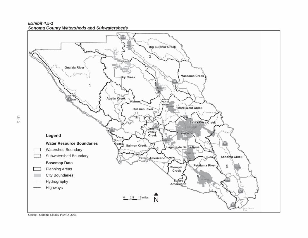
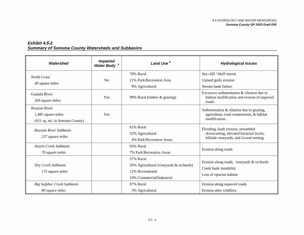
The following section describes the important characteristics of Sonoma County watersheds and subbasins. 3 These watersheds and subbasins are illustrated in Exhibit 4.5-1 and summarized in Exhibit 4.5-2.
North Coast Watershed
The North Coast watershed is comprised of 49 square miles of coastal area in western Sonoma County. It consists of a number of smaller watersheds, or subbasins, containing small creeks that drain directly to the Pacific Ocean. The elongated watershed has an average width of 1.5 miles and stretches approximately 30 miles north from the town of Jenner at the mouth of the Russian River to the Mendocino County Line south of the town of Gualala. Elevations range from approximately 2,000 feet mean sea level (MSL) at the tops of the steep mountain ridges along the eastern boundary of the watershed to sea level. Runoff in these areas generally flows west via a series of generally steep intermittent streams that flow into the ocean at several locations along the coast. Major streams within the watershed include Russian Gulch, Kolmar Gulch, Stoekhoff Creek, Miller Creek, and Stewarts Creek.
The climate along the coast is generally mild throughout the year. Vegetation along the coastal margin is dominated by nonnative grassland and closed cone pine forest (Bishop Pine, Monterey Cypress). Coastal redwood forest with Douglas fir and tan oak occur in the eastern portion of the watershed, approximately one half-mile inland. Most the land in the North Coast watershed is rural (70 percent) and used predominantly for grazing, timber production, and some rural residential development exists on large lots. Other land uses in the watershed include public recreation (21 percent) in State and county parks and beaches, and agricultural crop production (9 percent). This watershed is lightly urbanized. Fort Ross, Timber Cove, Stewarts Point, Salt Point State Park, and the community of Sea Ranch are located in this watershed.
Generally, flooding problems within the North Coast watershed consist of coastal flooding associated with elevated sea levels and wave run up during large storm events, or, very rarely, with tsunamis, also called tidal waves, that are caused by earthquakes underneath the ocean floor. Tsunami hazards are discussed in Section 4.7 Geology / Soils.
The North Coast Regional Water Quality Control Board (RWQCB) has not classified any waterways within the North Coast Watershed as impaired. The main watershed management issues are sea cliff or bluff retreat, upland gully erosion of historically intensively grazed rangeland areas, erosion following large wildfires of brush land and forested areas, and streambank failure along the many intermittent creeks along the coast.
The watershed information summarized in pages 4.5-1 thru 4.5-16 is a compilation of several sources and methods that are listed in Appendix 7.8 Hydrology and Geology Source Information.
4.5 - 2
3
4.5 - 3
Exhibit 4.5-1 Sonoma County Watersheds and Subwatersheds
Legend
Water Resource Boundaries Watershed Boundary Subwatershed Boundary
Basemap Data Planning Areas City Boundaries Hydrography Highways
0 2.5 5 miles N
Source: Sonoma County PRMD, 2005
4.5 HYDROLOGY AND WATER RESOURCES Sonoma County GP 2020 Draft EIR
Exhibit 4.5-2 Summary of Sonoma County Watersheds and Subbasins
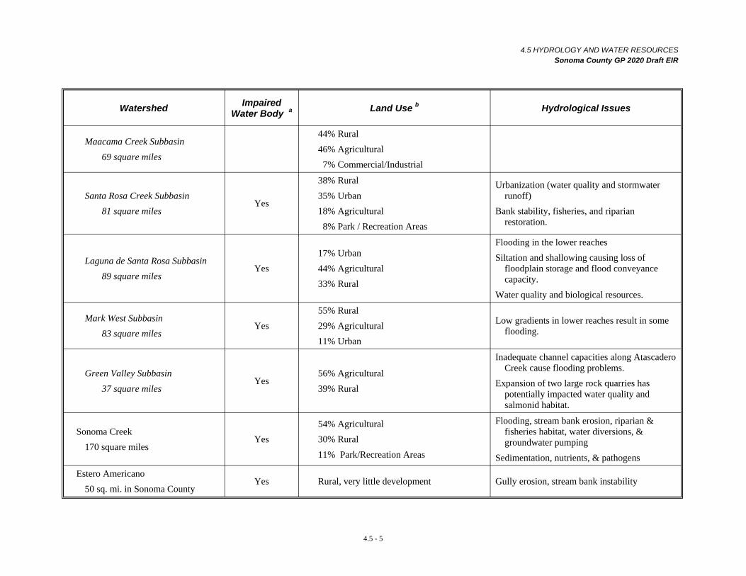
Watershed Impaired Water Body a Land Use b Hydrological Issues
North Coast 70% Rural Sea cliff / bluff retreat
49 square miles No 21% Park/Recreation Area
9% Agricultural Upland gully erosion Stream bank failure
Gualala River 269 square miles
Yes 99% Rural (timber & grazing) Excessive sedimentation & siltation due to
habitat modification and erosion of unpaved roads.
Russian River Sedimentation & siltation due to grazing, 1,485 square miles Yes agriculture, road construction, & habitat (921 sq. mi. in Sonoma County) modification.
Russian River Subbasin 237 square miles
61% Rural 32% Agricultural 4% Park/Recreation Areas
Flooding, bank erosion, streambed downcutting, elevated bacterial levels, hillside vineyards, and Gravel mining.
Austin Creek Subbasin 93% Rural 70 square miles 7% Park/Recreation Areas
Erosion along roads
57% Rural Dry Creek Subbasin
175 square miles 20% Agricultural (vineyards & orchards) 12% Recreational 10% Commercial/Industrial
Erosion along roads, vineyards & orchards Creek bank instability Loss of riparian habitat
Big Sulphur Creek Subbasin 97% Rural Erosion along unpaved roads 80 square miles 3% Agricultural Erosion after wildfires
4.5 - 4
4.5 HYDROLOGY AND WATER RESOURCES Sonoma County GP 2020 Draft EIR
Watershed Impaired Water Body a Land Use b Hydrological Issues
44% Rural Maacama Creek Subbasin
69 square miles 46% Agricultural 7% Commercial/Industrial
38% Rural Urbanization (water quality and stormwater Santa Rosa Creek Subbasin
Yes 35% Urban runoff)
81 square miles 18% Agricultural Bank stability, fisheries, and riparian 8% Park / Recreation Areas restoration.
Laguna de Santa Rosa Subbasin 89 square miles
Yes 17% Urban 44% Agricultural 33% Rural
Flooding in the lower reaches Siltation and shallowing causing loss of
floodplain storage and flood conveyance capacity.
Water quality and biological resources.
Mark West Subbasin 83 square miles
Yes 55% Rural 29% Agricultural 11% Urban
Low gradients in lower reaches result in some flooding.
Green Valley Subbasin 37 square miles
Yes 56% Agricultural 39% Rural
Inadequate channel capacities along Atascadero Creek cause flooding problems.
Expansion of two large rock quarries has potentially impacted water quality and salmonid habitat.
Sonoma Creek 170 square miles
Yes 54% Agricultural 30% Rural 11% Park/Recreation Areas
Flooding, stream bank erosion, riparian & fisheries habitat, water diversions, & groundwater pumping
Sedimentation, nutrients, & pathogens
Estero Americano 50 sq. mi. in Sonoma County
Yes Rural, very little development Gully erosion, stream bank instability
4.5 - 5
4.5 HYDROLOGY AND WATER RESOURCES Sonoma County GP 2020 Draft EIR
Watershed Impaired Water Body a Land Use b Hydrological Issues
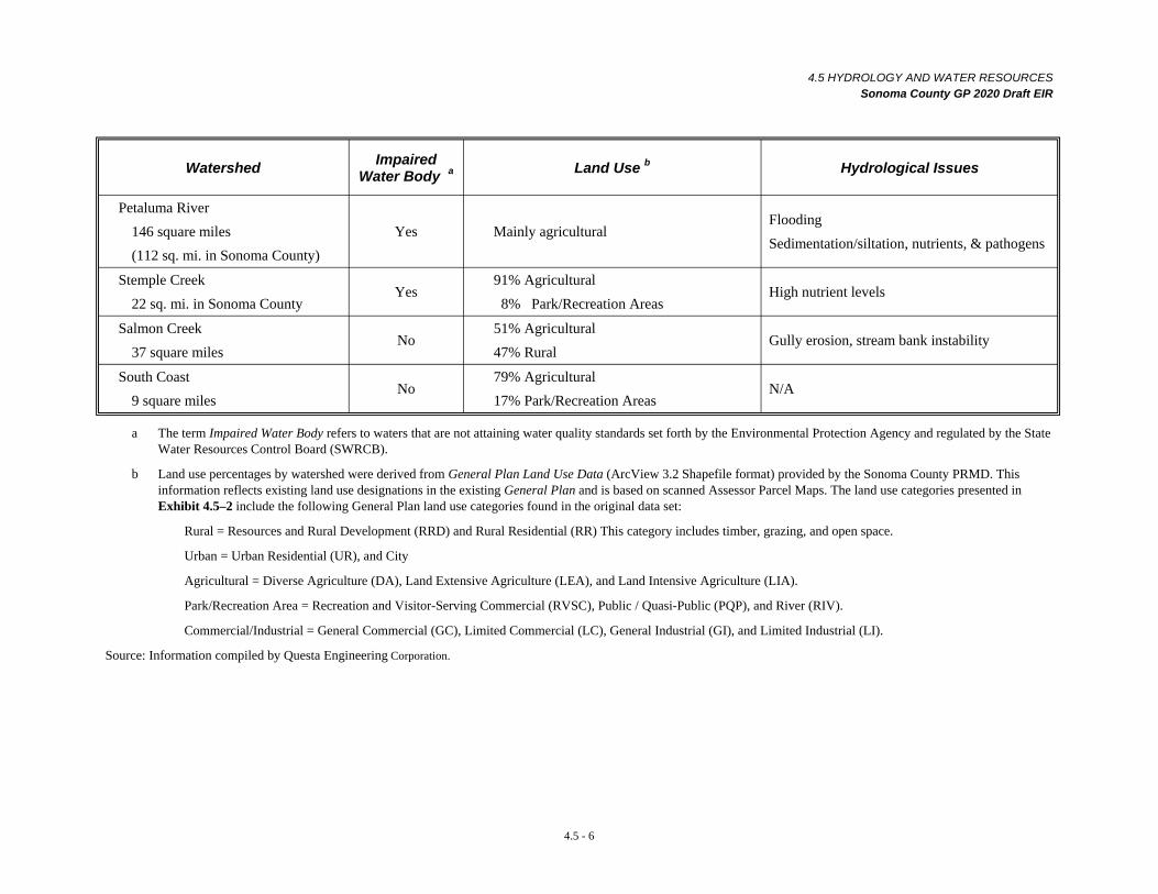
Petaluma River 146 square miles (112 sq. mi. in Sonoma County)
Yes Mainly agricultural Flooding Sedimentation/siltation, nutrients, & pathogens
Stemple Creek 22 sq. mi. in Sonoma County
Yes 91% Agricultural
8% Park/Recreation Areas High nutrient levels
Salmon Creek 37 square miles
No 51% Agricultural 47% Rural
Gully erosion, stream bank instability
South Coast 9 square miles
No 79% Agricultural 17% Park/Recreation Areas
N/A
a The term Impaired Water Body refers to waters that are not attaining water quality standards set forth by the Environmental Protection Agency and regulated by the State Water Resources Control Board (SWRCB).
b Land use percentages by watershed were derived from General Plan Land Use Data (ArcView 3.2 Shapefile format) provided by the Sonoma County PRMD. This information reflects existing land use designations in the existing General Plan and is based on scanned Assessor Parcel Maps. The land use categories presented in Exhibit 4.5–2 include the following General Plan land use categories found in the original data set:
Rural = Resources and Rural Development (RRD) and Rural Residential (RR) This category includes timber, grazing, and open space.
Urban = Urban Residential (UR), and City
Agricultural = Diverse Agriculture (DA), Land Extensive Agriculture (LEA), and Land Intensive Agriculture (LIA).
Park/Recreation Area = Recreation and Visitor-Serving Commercial (RVSC), Public / Quasi-Public (PQP), and River (RIV).
Commercial/Industrial = General Commercial (GC), Limited Commercial (LC), General Industrial (GI), and Limited Industrial (LI).
Source: Information compiled by Questa Engineering Corporation.
4.5 - 6
4.5 HYDROLOGY AND WATER RESOURCES Sonoma County GP 2020 Draft EIR
Gualala River Watershed
The Gualala River watershed runs parallel to the coast of southern Mendocino and northern Sonoma Counties. In Sonoma County, the watershed is bounded on the west by the North Coast watershed and drains approximately 269 square miles. The Gualala River watershed has an average width of 14 miles and runs approximately 30 miles south to north from near Fort Ross to the town of Gualala in Mendocino County. Major streams and tributaries to the Gualala River located in the Sonoma County portion of the watershed include: Big Pepperwood Creek, Rockpile Creek, Buckeye Creek, Wheatfield Fork, Marshall Creek, Sprould Creek, McKenzie Creek, and Carson Creek. The Gualala River supports an important steelhead fishery, and some of these tributaries contain important spawning and juvenile fish rearing areas. The small community of Annapolis is in this watershed. Virtually all of the terrain within the watershed is rugged and mountainous. Elevations range from sea level to roughly 2,602 feet above mean sea level (MSL) at Gube Mountain. A large landslide deposit extending approximately five miles has been mapped along east-facing slopes of the Gualala River valley in the northern portion of the watershed and likely contributes significant sediment to local waterways.
While the climate near the coast is generally mild throughout the year, temperature in inland areas can vary greatly. Redwood forests occupy the northwestern portion of the watershed, especially in fog influenced bottomland areas, while Douglas fir dominates in central and mid-slope locations more distant from the coast, especially on north facing slopes. Further inland in the eastern portion of the watershed, Douglas fir forests are fragmented by oak woodland and large prairie grasslands.
Because of the steep, rugged terrain there are a limited number of land uses that occur within the Gualala River watershed. Logging began during the mid-1800s. In the early days, after being logged, forests were often burned in an attempt to clear the land for grazing purposes. Natural clearings as well as human-cleared areas on the eastern side of the watershed were used historically for grazing. Grazing has declined since the 1980’s, but some small-scale timber harvesting operations in the Gualala River watershed are still active today. While only a small number of paved roads traverse the rugged terrain of the watershed, a well-developed network of unpaved forest roads occurs throughout. Erosion of road cut faces and at unimproved drainage crossings are contributors of sediment to the Gualala River system. The combination of inherently unstable ground, climate, and the past intensive grazing and timber production has led to accelerated erosion within the Gualala River watershed. The State Water Resources Control Board (SWRCB) has characterized the Gualala River as an impaired water body due to excessive sedimentation and siltation of local waterways and elevated temperatures. It has been estimated that while natural sediment yield accounts for one third of the total sediment delivery in the Gualala River watershed, human-caused sediment accounts for two thirds of the sediment delivery in the watershed. Land use factors contributing to accelerated erosion and sedimentation are partially attributed to: 1) failure of streamside logging roads during major storm events; 2) landslides and slope instabilities resulting from poor logging practices; and 3) poorly designed vineyards in steep upland areas of the watershed. The removal of trees that provide shade over waterways may contribute to elevated water temperatures.
Watershed planning activities, including completion of biological inventories and a hydrologic analysis, are currently being conducted for the Gualala River watershed by the State Coastal Conservancy and several other State agencies, in cooperation with the Gualala River Watershed Council. The California Geological Survey also recently completed a geologic and geomorphic study of the watershed, as part of the North Coast Watershed Assessment Program.
4.5 - 7
4.5 HYDROLOGY AND WATER RESOURCES Sonoma County GP 2020 Draft EIR
Russian River Watershed
The Russian River watershed occupies much of both Mendocino and Sonoma Counties. The watershed occupies an area of roughly 1,485 square miles, approximately 770 square miles of which are located in Sonoma County. In Sonoma County, the Russian River watershed has been divided into nine subbasins for the purposes of this EIR: Russian River; Dry Creek; Big Sulphur Creek; Green Valley Creek; Laguna de Santa Rosa; Santa Rosa Creek; Maacama Creek; Austen Creek; and Mark West Creek
The North Coast RWQCB and several other agencies have monitored the water quality of the Russian River watershed since the early 1970’s. Monitoring results indicate that levels of total nitrate, total phosphate, dissolved oxygen (DO), hydrogen ion concentration (pH), and toxic chemical (carcinogenic and non-carcinogenic organic chemicals) concentration are, for the most part, in compliance with water quality objectives. Elevated water quality constituents in the main stem of the Russian River are generally associated with total dissolved solids (TDS), turbidity, and high bacteria concentrations. Recreational users and malfunctioning individual septic systems contribute to the introduction of fecal coliform bacteria into the river.
The North Coast RWQCB has classified the entire Russian River watershed as an impaired water body due to excessive sedimentation and siltation. The impairment is attributed to historic grazing, agriculture, logging, road construction, and habitat modification.
The majority of areas subject to flooding in the Russian River basin are adjacent to the Russian River between Mirabel Park and Duncans Mills. Flooding has occurred along the lower and middle reaches of the Russian River and is a natural renewal process of the river. Coyote and Warm Springs Dams provide flood protection from overflow of the Russian River during winter and spring months.
Floods in the Russian River watershed are generally of short duration, lasting three to four days. They normally develop within 24 to 48 hours after the beginning of a large flood-producing storm event, and recede within two to three days or less of the end of the storm. Typically, flows in the smaller tributaries to the Russian River rise so rapidly that flooding occurs within four to six hours of a storm event. Some of the lands along the Russian River in the vicinity of Cloverdale have been partially protected by levees. However, flood flows often break out of the Russian River at predictable low points or areas of constriction. Although flood frequency and base flood elevations (BFEs) have been reduced along this part of the river by the construction and operation of the Coyote Dam in Mendocino County, and the Warm Springs Dam project, repetitive major flood problems still persist along the lower river in Guerneville.
Bank stabilization and erosion control projects have been constructed along the main stem of the Russian River by the U.S. Army Corps of Engineers and individual property owners. The maintenance responsibility for projects installed by the U.S. Army Corps of Engineers is generally the responsibility of local interests. Erosion and sedimentation in the main stem is often associated with peak releases from dams.
Subbasins of the Russian River watershed are described below.
Russian River Subbasin
The Russian River subbasin consists of roughly 237 square miles in central Sonoma County. The subbasin follows the course of the Russian River Valley floor as it curves and bends from the broader inland valley areas in north central Sonoma County, flowing southeast along US 101 to the narrow
4.5 - 8
4.5 HYDROLOGY AND WATER RESOURCES Sonoma County GP 2020 Draft EIR
mountain flanked river corridor where it turns west along Highway 116 towards the coast. Major communities along the river include Cloverdale at the north end, Geyserville and Healdsburg in the Alexander Valley, Mirabel Park, Rio Del, Guerneville and Monte Rio in the middle river corridor, and Jenner, where the river discharges into the Pacific Ocean.
Although the valley floor is relatively flat, it is flanked on either side by steep to moderately steep mountain ridges that form the topographic divide between other subbasins of the watershed. The subbasin is approximately 45 miles in length, with an average width of six miles. Elevations within the subbasin range from to sea level to 3,250 feet above MSL along mountain ridges east of Cloverdale. Major tributaries to the subbasin (Dry Creek, Big Sulphur Creek, Maacama Creek, Santa Rosa Creek, Green Valley Creek, Austin Creek, Mark West Creek, and Laguna de Santa Rosa) are described as separate subbasins below.
Temperatures within the Russian River subbasin vary greatly with elevation. Vegetation in upper parts of the watershed has been altered by human activities, with prior forested lands converted in some areas to vineyard and orchard crops. Coastal areas of the lower watershed consist primarily of annual grassland and Redwood forest. Land use within the subbasin is primarily rural (61 percent) and agricultural (32 percent) but there has been an increasing trend of light industrial and commercial in urban areas such as Guerneville, Healdsburg, and Cloverdale. Tourism, vineyards, and wine production are major industries, with only a very small amount of timber production. Gravel mining along the Russian River has also been an important part of the watershed economy, although a major long term goal of the County’s Aggregate Resources Management Plan (ARM) has been to shift reliance from river and terrace mining to hillside quarries.
Major watershed management challenges in this watershed include flooding, and significant bank erosion and streambed downcutting, especially in the upper reaches of the river. River downcutting may be linked to the geomorphic consequences of removal of bedload from the river, although this is uncertain. Lateral bank erosion along with agricultural activities has greatly reduced the width and extent of the historic riparian corridor along major parts of the river contributing to elevated river temperatures. As discussed later in this section, water quality problems, especially elevated bacterial levels remain an area of significant concern. The increased development of hillside vineyards in portions of this watershed subbasin and concerns over erosion from poor vineyard development practices led to the development of a county vineyard erosion control ordinance in 2000.
Austin Creek Subbasin
The Austin Creek subbasin is located in east-central Sonoma County. The subbasin, draining an area of roughly 70 square miles, flows south to the Russian River near Duncan Mills. The unincorporated town of Cazadero is the largest community in this watershed. Elevations range from over 2,000 feet MSL at Queen’s Peak in the eastern portion of the subbasin to 50 feet MSL at the confluence of Austin Creek and the Russian River. Portions of this watershed receive up to 100 inches of rainfall annually. Major streams and tributaries in the subbasin include Austin Creek, East Austin Creek, Gray Creek, Schoolhouse Creek, Gilliam Creek, Thompson Creek, Ward Creek, Blue Jay Creek, Bearpen Creek, Red Slide Creek, Conshea Creek, and Black Rock Creek.
The steepest slopes in the headwaters of the Austin Creek subbasin are vegetated with Douglas fir and oak woodland. Vegetation in the lower elevations of the subbasin consists of Coast Redwoods and nonnative grassland and chaparral shrubs. Virtually the entire subbasin is rural (93 percent), with a small portion consisting of public parks and recreational areas (seven percent). Some small-scale timber harvesting operations still occur in this watershed. Historic timber harvesting of the mountain slopes and the construction of historic logging roads, many of which have been converted to property
4.5 - 9
4.5 HYDROLOGY AND WATER RESOURCES Sonoma County GP 2020 Draft EIR
access roads, has resulted in some areas with high soil erosion rates. Accelerated soil erosion along secondary roads, including some areas of landsliding, is the major watershed management issue that needs to be addressed.
Dry Creek Subbasin
Dry Creek, a major tributary to the Russian River, drains an area of approximately 175 square miles of north central Sonoma County. The western portion of the town of Healdsburg is located in this subbasin. Elevations in the subbasin range from 100 feet MSL in the lower valley area near Healdsburg, to approximately 4,000 feet MSL in the upland areas surrounding Red Mountain. While the headwaters are steep and rugged, the southern half of the subbasin opens up to the wide alluvial plain of Dry Creek. Major streams and tributaries in the subbasin include Cherry Creek, Galloway Creek, Smith Creek, Warm Springs Creek, Mill Creek, and Wallace Creek. Lake Sonoma, artificially created by the Warm Springs Dam at the confluence of Dry Creek, is the largest water body in the subbasin.
Vegetation in the Dry Creek subbasin consists mostly of oak woodland with areas of Douglas fir forest, mainly on north facing slopes, and with patches of chaparral, coast redwood, nonnative grassland, vineyard, and cropland. Land use in the subbasin is consists of rural (57 percent), agricultural, mainly vineyards and orchards (20 percent), and recreational (12 percent) land uses.
Watershed management problems include upland erosion along secondary roads and from vineyard and orchard areas, creek bank instability, and the loss of riparian habitat. The historic flooding problems along Dry Creek have largely been controlled by construction of the Warm Springs Dam.
Big Sulphur Creek Subbasin
Big Sulphur Creek, a tributary to the Russian River, drains approximately 80 square miles of northeastern Sonoma County. The historic Geysers Resort is located in this watershed. The subbasin is bound to the east by the Mayacamas Mountain Range and to the west by the Alexander Valley. Elevations in the watershed range from up 4,000 feet MSL along the border between Sonoma and Lake Counties, to approximately 400 MSL at the confluence of Big Sulphur Creek and the Russian River. Major streams and tributaries within the subbasin include Big Sulphur Creek, Little Sulphur Creek, Squaw Creek, Cobb Creek, Alder Creek, and Frasier Creek.
The Big Sulphur Creek subbasin is characterized by steep rugged terrain. Subbasin vegetation consists of chaparral, oak woodland, and some areas of mixed oak and pine forests at higher elevations and north slopes. Land-use in the subbasin is almost entirely rural (97 percent), with a small amount of agriculture (three percent) in the south. The most significant watershed management issue in this watershed is erosion along historic unpaved secondary access or utility roads, especially in the Geysers geothermal field area. The County and the California Energy Commission have policies and procedures in place for erosion control and sensitive area protection associated with new geothermal resource development in this area. Erosion following large brush land wildfires is also a management concern.
Maacama Creek Subbasin
The Maacama Creek subbasin, a small tributary to the Russian River, is located in east-central Sonoma County. The subbasin drains an area of 69 square miles. Elevations in the subbasin range from 120 feet MSL near the confluence of Maacama Creek and the Russian River to approximately 4,300 at Mount St. Helena. Major streams and tributaries include Maacama Creek, Franz Creek,
4.5 - 10
4.5 HYDROLOGY AND WATER RESOURCES Sonoma County GP 2020 Draft EIR
Bidwell Creek, Kellogg Creek, Little Briggs, and Redwood Creek. Knights Valley and the very small community of Kellogg occur in this area.
Vegetation in the subbasin is predominantly brush land and oak woodland intermixed with open Douglas fir and pine forests at higher elevations and north facing slopes. The land use in the upper portions of the subbasin is primarily rural residential (44 percent). The lower portion, which is in the vicinity of Knights Valley, is predominately agricultural (46 percent). The land use in the Mount St. Helena area is zoned recreational (3 percent). The remaining land use is zoned commercial or industrial.
Santa Rosa Creek Subbasin
The Santa Rosa Creek subbasin is located eastern and central Sonoma County. This roughly T-shaped subbasin drains an area of roughly 81 square miles. Elevations range from approximately 2,000 feet MSL along the easternmost boundary of the subbasin to roughly 100 feet MSL near the westernmost boundary. Major streams and tributaries in the subbasin include Santa Rosa Creek, Spring Creek, Brush Creek, Matanzas Creek, Colgan Creek, and Rincon Creek.
The central region of the Santa Rosa Creek watershed is largely urbanized (35 percent of the subbasin). Vegetation in the lower or south limb of the watershed is generally oak woodland on the slopes of the Sonoma Mountains and above Bennett Valley; in the eastern limb, oak woodland and Douglas fir forest, with the western limb, cropland and pasture.
The climate of the Santa Rosa Creek subbasin is cool, with mean temperatures ranging from 47 degrees Fahrenheit in winter to 68 degrees Fahrenheit during summer months. Average annual precipitation is approximately 30 inches.
Floodplain areas near the confluence of Santa Rosa Creek and Mark West Creek are subject to flooding during the 100-year storm event.
Watershed management issues in this watershed are primarily related to changes in stormwater runoff volumes and timing of peak flows, and water quality from urbanization. Bank instability, fisheries enhancement, and riparian restoration are also important issues
The City of Santa Rosa, in cooperation with the SCWA and the Committee for Restoring Santa Rosa Creek have been very active in the Santa Rosa Creek watershed, including completion of major creek restoration projects on Santa Rosa Creek and Brush Creeks, based on a Creek Master Plan, completed in 1992. The City is currently developing a City-wide Creek Plan that will address other creeks in this watershed, and has developed conceptual restoration plans for a number of creeks.
Laguna de Santa Rosa Subbasin
The Laguna de Santa Rosa subbasin drains an area of 89 square miles in south-central Sonoma County with the upper watershed originally on the west-facing slopes of the Sonoma Mountains. In the upper portions of the watershed are the cities of Rohnert Park and Cotati, as well as Sonoma State University. The city of Sebastopol is located in the lower part of the Laguna subbasin. In the northern part of the subbasin, Laguna de Santa Rosa converges with Mark West Creek prior to flowing to the Russian River. Elevations in range from 50 feet in the north, approximately one-half mile south of Mark West Creek, to 1400 feet MSL at Taylor Mountain. The primary waterway is Laguna de Santa Rosa, with major streams and tributaries being Blucher Creek, Hinebaugh Creek, Washoe Creek, and Gossage Creek.
4.5 - 11

4.5 HYDROLOGY AND WATER RESOURCES Sonoma County GP 2020 Draft EIR
A portion of the Laguna de Santa Rosa watershed has been urbanized (17 percent) or is in agricultural production (44 percent). Historic apple orchards around Sebastopol are being converted to vineyards in some areas, with new large-scale vineyard plantings on the foothills near Cotati and on the slopes of the Sonoma Mountains. Much of the remainder of the watershed land use is rural residential (33 percent). Vegetation in the rural areas includes oak woodlands on Sonoma Mountain, pasture and oat hay lands, and grazing lands in the valley bottoms and lower slopes, and along the mountain slopes in the northwest edge of the subbasin, mixed Douglas fir forest and oak woodland.
Flooding in the lower reaches of the Laguna de Santa Rosa is from backwater effects during major flooding along the Russian River and is a significant problem along low lying areas in the City of Sebastopol. Portions of the Laguna near Rohnert Park and Cotati have been channelized, including several urban tributaries.
One of the more significant watershed management problems is the siltation and shallowing of the Laguna. The broad, relatively flat gradient of the Laguna provides a natural floodplain storage area, and flooding would often be much worse downstream without the benefits provided by this storage. The loss of floodplain storage and the reduction of channel flood conveyance capacity due to siltation from sediment sources higher in the watershed are of major concerns to the SCWA, and are being investigated by the Corps of Engineers. An invasive water weed, Ludwigia, has also recently become a significant concern along the Laguna de Santa Rosa as it prevents effective management of mosquitoes. The high nutrient levels and shallow open waters of the Laguna favor the growth of this plant.
Other major watershed management issues of importance to local watershed stakeholders include protection of Laguna water quality, and the protection and restoration of the biological resources of the Laguna ecosystem, which supports a large number of endangered and protected animal and plant species.
Mark West Creek Subbasin
The Mark West Creek subbasin, located in northeastern Sonoma County, covers an area of approximately 83 square miles. The Town of Windsor, and the northern outskirts of the Santa Rosa urban area are in this watershed. The primary stream in the subbasin, Mark West Creek, is a tributary to the Russian River. Elevations in the subbasin range from 50 feet MSL near the confluence of Mark West Creek and the Russian River to over 2,000 feet MSL near Diamond Mountain in the eastern subbasin. Major Creeks and tributaries in the subbasin include Mark West Creek, Windsor Creek, Porter Creek, Wright Creek, Poole Creek, Mill Creek, and Van Buren Creek.
Topography in the Mark West subbasin divides the vegetation into two distinct areas. Uphill areas in the western half of the subbasin are densely vegetated by oak woodland and some Douglas fir forest. In contrast, gently sloped areas in the eastern half of the subbasin are generally grasslands with scattered oaks, or are urban and suburban areas. In addition, there are some areas of cropland and pasture, with vineyard plantings both on the valley bottom and the valley side slopes. The eastern portion of the Mark West Creek subbasin is bound by the Sonoma Mountains.
Low gradients in the lower reaches of Windsor, Poole, and Mark West Creeks cause water from the Russian River to backup and flood some portions of the western subbasin during high-intensity, short-duration storm events.
4.5 - 12

4.5 HYDROLOGY AND WATER RESOURCES Sonoma County GP 2020 Draft EIR
Green Valley Subbasin
The Green Valley subbasin is a tributary to the Russian River. The northwest corner of Sebastopol and the town of Forestville are located in this watershed. The subbasin drains an area of 37 square miles. Subbasin elevations range from 110 feet MSL at the confluence of Green Valley Creek and the Russian River to roughly 900 feet MSL at English Hill. Major creeks in the subbasin include Green Valley Creek, Atascadero Creek, and Purrington Creek.
Major portions of this subbasin consist of grassland and pasture areas, with some vineyards, and apple orchards. The higher lying slopes are covered with oak woodlands and Douglas fir forest.
Inadequate channel capacities along Atascadero Creek result in flooding problems in the outskirts of the City of Sebastopol during high-intensity, short-duration storm events.
There are two large rock quarries located in this subbasin, just outside of Forestville. The expansion of these two quarries has raised concerns regarding water quality and salmonid habitat along portions of Green Valley Creek. The increase in rural residential development in this area may also be affecting water quality in the subbasin.
Sonoma Creek Watershed
The Sonoma Creek watershed is located in the southeastern corner of Sonoma County. The City of Sonoma and the unincorporated communities of Boyes Hot Springs, Agua Caliente, Fetters Hot Springs, and Glen Ellen are all located on the valley floor near the center of the elongated watershed, with the community of Schellville in the lower or southern portion, near the edge of San Pablo Bay, and Kenwood in the upper or north end. The watershed consists of approximately 170 square miles. Elevations in the watershed range from sea level at San Pablo Bay to approximately 2,500 feet MSL at Bald Mountain. Major creeks and tributaries in the Sonoma Creek watershed include Tolay Creek, Schell Creek, Fowler Creek, Arroyo Seco, Yulupa Creek, Graham Creek, Mill Creek, Wilson Creek, Agua Caliente Creek, Calabazas Creek, Nathanson Creek, Dowdall Creek, Carriger Creek, Felder Creek, Asbury Creek, and Bear Creek.
The central part of the Sonoma Creek watershed on the valley bottom is mostly urbanized, while the lower creek valley is mostly in agricultural production. Approximately 54 percent of the watershed is in agricultural use, 30 percent is rural and about 11 percent is recreational. The vegetative cover of the hill slopes of the watershed, where not converted to vineyards, is mostly oak woodland and Douglas fir forests, with some areas of brush.
Flooding in the Sonoma Creek watershed is the result of intense, short-duration rainfall occurring within a larger duration storm event. Tidal action in the San Pablo Bay has a variable effect on flooding in the Sonoma Creek watershed. While flooding above the reclaimed tidal area is of relatively short duration, floodwater ponding in the floodplain adjacent to the San Pablo Bay can last for a few days. The principal flood problems in the main channel are caused by inadequate channel capacity to carry off large flows from short-duration storms of high intensity. Flood problems are accentuated by encroachment of residential development on the channels.
The San Francisco Bay RWQCB has classified the Sonoma Creek watershed as an impaired water body due to sedimentation, nutrients, and pathogens. The development of vineyards on steep hillsides, especially in the 1980s and early 1990s before the county developed vineyard erosion control regulations, has been attributed to be one of the major causes of erosion and sedimentation. This and other related watershed management issues were evaluated and addressed in the Sonoma Creek
4.5 - 13

4.5 HYDROLOGY AND WATER RESOURCES Sonoma County GP 2020 Draft EIR
Watershed Management Plan, with implementation currently underway by the Southern Sonoma Resource Conservation District (RCD) and the Sonoma Ecology Center through educational and outreach programs with stakeholder groups, including the Sonoma Valley Vintners and Growers Alliance.
The expansion of wineries and resultant wastewater management issues and the limitations in wastewater treatment plant capacity may be responsible for elevated pathogen levels within the watershed, as unlike the adjacent Petaluma River watershed, there are few dairies in this watershed. Other watershed management issues include flooding, stream bank erosion, riparian and fisheries habitat enhancement, and the effect of water diversions and groundwater pumping for vineyard irrigation on summer flow in creeks.
Estero Americano Watershed
The Estero Americano watershed is located in both Sonoma and Marin Counties and drains an approximate area of 49 square miles in Sonoma County. Elevations in the watershed range from just above sea level at the town of Bodega Bay and Bodega Harbor to roughly 650 feet in northern portions of the watershed. Creeks and tributaries in the watershed drain south to the Estero Americano, which flows west along the Sonoma / Marin County border to empty into the Pacific Ocean at a large natural tidal lagoon or estuary. Major tributaries to the Estero Americano include Cheney Gulch, Johnson Gulch, Ebabias Creek, and Stemple Creek. The majority of the Estero Americano watershed is in non-intensive agricultural production, with some oat hay lands, irrigated pasture, and extensive areas of dry pasture. Dairies and beef and sheep livestock ranches constitute a considerable portion of the watershed economy.
The Estero Americano has been classified by the North Coast RWQCB as an impaired water body due to high levels of nutrients and sedimentation/siltation. These watershed management issues are generally attributed to livestock grazing, management of dairy manure lagoons, streambank modification, and other agriculturally-related non-point sources. 4 Some of the problems are historical in origin, as the area was used farmed and grazed more intensively in the past.
Stemple Creek Subbasin
The Stemple Creek subbasin, a tributary to the Estero Americano watershed, is located in both Sonoma and Marin Counties. The subbasin begins just west of the City of Petaluma and empties into the Pacific Ocean through the Estero de San Antonio in Marin County. The creek drains approximately 22 square miles of southern Sonoma County. Subbasin elevations range from 600 feet MSL in the northern upland areas of the watershed to roughly 50 feet MSL in the south.
Virtually the entire Stemple Creek subbasin is in non-intensive agricultural production. Dairies and beef and sheep livestock ranches are the mainstay of the subbasin economy. Stemple Creek has been classified by the North Coast RWQCB as an impaired water body due to high nutrient levels. High nutrient levels are likely the result of the intensive use of pasture land and dairy manure lagoon management practices, including the spreading and spraying of lagoon wastes.
Non-point source pollution is discussed in Impact 4.5-1 Water Quality – Residential, Commercial, Industrial, and Public Uses.
4.5 - 14
4
4.5 HYDROLOGY AND WATER RESOURCES Sonoma County GP 2020 Draft EIR
Salmon Creek Watershed
The Salmon Creek watershed is a relatively small coastal watershed located north of Bodega Bay, draining approximately 37 square miles of western Sonoma County and discharging into the Pacific Ocean. Elevations in the watershed range from seal level to roughly 1200 feet MSL. Major creeks and tributaries in the watershed include Salmon Creek, Tannery Creek, Nolan Creek, Thurston Creek, Finley Creek, and Coleman Valley Creek.
This is one of the least disturbed watersheds in the county, with relatively few paved roads other than the Highway 1 (the Coast Highway), Joy Road, Coleman Valley Road, and the Bodega Highway. Salmon Creek supports both Coho and steelhead salmon. The small communities of Bodega and Freestone occur in this watershed.
Gully erosion of watershed lands, streambank instability, and enhancement of fishery habitat are among the major watershed management issues of this watershed. Salmon Creek is currently not listed as an impaired water body.
Petaluma River Watershed
The Petaluma River watershed is located in southern Sonoma and northern Marin Counties. Approximately 112 square miles of the 146 square mile watershed are located in Sonoma County. The City of Petaluma and the unincorporated community of Penngrove are located in this watershed. A portion of the Town of Novato and outlying unincorporated areas are located in the lower watershed.
Elevations in the watershed range from sea level at San Pablo Bay to about 3,000 feet MSL at Sonoma Mountain. Major tributaries to the Petaluma River in Sonoma County include Willow Brook, Lichau Creek, Lynch Creek, Adobe Creek, Ellis Creek, Liberty Creek, Marin Creek, and San Antonio Creek, which forms the border with Marin County. The lower 12 miles of the Petaluma River flow through the Petaluma Marsh. The river ultimately empties into the northwest portion of San Pablo Bay. Tidal influence extends approximately 14 miles upstream of San Pablo Bay, to near the confluence of Lynch Creek above downtown Petaluma.
Humans have played a large role in the alteration of the geometry and dimensions of the Petaluma River over time. Originally, a large portion of the river was actually a narrow, winding, and relatively shallow tidal slough. Dredging, deepening, straightening, and widening of the slough began in the 1850’s to allow for the transport of goods via river from the north to San Francisco. Further widening and deepening of the creek occurred in 1880 and again in 1931 by the U.S. Army Corps of Engineers. The channel has been significantly altered all the way to the downtown area of Petaluma. In 1959, Petaluma Creek was officially declared a river by an Act of Congress. Because of its flat gradient and tidal influence, the river must be dredged about every four years to maintain navigability. The Petaluma River is one of the few remaining rivers in California that continue to support commercial river traffic. This allows the river dredging to be funded by Congress, but requires a special funding appropriation.
The majority of the Petaluma River watershed is in non-intensive agricultural production, including large areas of oat hay production and dairy cattle and sheep grazing lands. Irrigated hay and pasture lands (irrigated with reclaimed water from the City of Petaluma treatment plant) occur to the southeast of the city, along Lakeville Highway. From the late 19th century through the middle of the 20th
century, chicken and egg products constituted a major source of income in the area. By the late 20th
century, the chicken industry declined, and dairies and vineyard developments began to flourish
4.5 - 15
4.5 HYDROLOGY AND WATER RESOURCES Sonoma County GP 2020 Draft EIR
throughout the watershed. Vineyard development has occurred throughout the watershed from the 1990’s to the present, including on Sonoma Mountain and along Lakeville Highway.
Flooding in the Petaluma River watershed is highly influenced by tidal action in the San Pablo Bay, particularly in the lower and middle river reaches. There are two main areas of significant flooding along the Petaluma River. The first area, between Denman Flat and the Lynch Creek confluence, consists mainly of scattered commercial, industrial, and undeveloped properties. The second area, referred to as the Payran Area Floodplain, lies between the Lynch Creek confluence and the Lakeville Street Bridge in the City of Petaluma, and consists mainly of residential properties developed during the 1960’s.
Floods in the watershed may develop within 24 hours of a flood-producing storm, normally also coincident with a high tide event, and will typically recede within one day after the storm has ended. The worst flooding has occurred where a series of closely spaced storms move through the watershed, maintaining saturated soils and prolonged high flows in the tributary creeks. The largest flood of record in the Petaluma River Watershed occurred in January 1982 and caused an estimated $28,000,000 in damages in 1982 dollars. Other damaging floods occurred in 1986, 1995, and 1998, especially in the flood prone Payran area. The City of Petaluma in cooperation with the U.S. Army Corps of Engineers, the State of California, and the SCWA has nearly finished implementation of the Payran Reach Flood Control Project. This project includes channel widening, the construction of floodwalls and pump stations, and the replacement of bridges and railroad crossings that are obstructions to flood flow.
The Southern Sonoma County RCD completed a watershed management plan covering the Petaluma watershed. The plan focuses on the rural areas outside of the City of Petaluma, and includes an assessment and prioritization of upland erosion, bank instability, stream restoration, and water quality management needs. A major focus of the plan is on coordinating the development of TMDL water quality standards and programs in a way that will be compatible with the needs of agricultural industry, as the preservation and protection of open space lands and the agricultural economy is a high priority for this watershed.
The San Francisco Bay RWQCB has classified the Petaluma River as an impaired water body due to sedimentation / siltation and high levels of nutrients and pathogens. High nutrient levels could be attributed to dairy farms, equine facilities, and livestock producers. Sedimentation problems in tributaries are generally associated with new development and agricultural land use practices. Pathogen problems are generally attributed to agriculture and urban runoff. Additionally, high levels of metals have been detected at the mouth of the Petaluma River, in San Pablo Bay. It has not yet been determined whether the Petaluma River is a source of the metals.
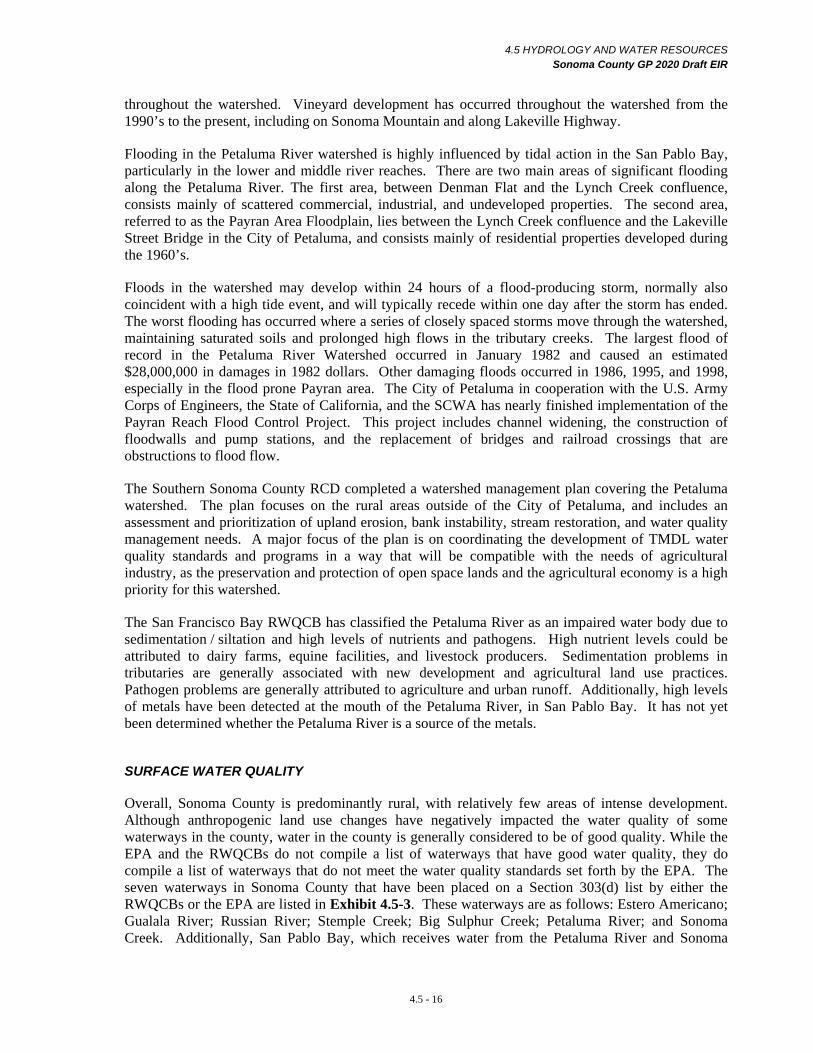
SURFACE WATER QUALITY
Overall, Sonoma County is predominantly rural, with relatively few areas of intense development. Although anthropogenic land use changes have negatively impacted the water quality of some waterways in the county, water in the county is generally considered to be of good quality. While the EPA and the RWQCBs do not compile a list of waterways that have good water quality, they do compile a list of waterways that do not meet the water quality standards set forth by the EPA. The seven waterways in Sonoma County that have been placed on a Section 303(d) list by either the RWQCBs or the EPA are listed in Exhibit 4.5-3. These waterways are as follows: Estero Americano; Gualala River; Russian River; Stemple Creek; Big Sulphur Creek; Petaluma River; and Sonoma Creek. Additionally, San Pablo Bay, which receives water from the Petaluma River and Sonoma
4.5 - 16

4.5 HYDROLOGY AND WATER RESOURCES Sonoma County GP 2020 Draft EIR
Creek, has also been listed as an impaired water body for thirteen constituents. TMDL planning, which will address the water quality issues identified, is in the early stages of development for most of these watersheds. The most prominent water quality problems affecting waterways in the county are: (1) sedimentation and siltation; (2) nutrients; and (3) pathogens, or high bacteria levels.
Sedimentation and Siltation
Sedimentation and siltation problems are widespread throughout the county. Although this can be partially attributed to local topography, geology, and soils, land use practices are also to blame. Several common causes of excess erosion, sedimentation, and siltation are described here.
Agricultural practices, particularly more intensive agricultural land use, can result in an increase in sediment in local waterways. Farming and intensive grazing on steep slopes with erosive soils, creating poor ground cover conditions, can lead to accelerated erosion and sedimentation of the waterways. Road and highway construction has also contributed to sedimentation of the waterways.
Nutrients
In the context of water quality, the term nutrients typically refer to excess concentrations of nitrogen and phosphorus. Several anthropogenic or man-caused sources of nutrients are known to affect water quality in Sonoma County.
Farmers apply chemical fertilizers to crops in the form of nitrogen, phosphorus, and potassium. These elements are also concentrated in manure lagoons and wastewater from septic systems. These elements, when transported via land spreading and runoff or through direct or indirect wastewater discharges to streams, rivers, or lakes, result in excessive algal growth, which in turn increases the turbidity of the water and results in diminished water quality.
Pathogens
The presence of coliform bacteria in water, which are normally found in the intestines of humans and animals, signals that disease-causing pathogens may be present. Elevated levels of fecal coliform bacteria are the most common pathogen problem affecting the quality of water in Sonoma County. Pathogens enter water through wastewater discharges, leaking septic systems, and from animal waste, including from animal concentration areas such as feedlots and dairies. Giardia and cryptosporidium are also pathogens that are occasionally found in public water supplies and have the potential to cause serious illness among people.
4.5 - 17
4.5 HYDROLOGY AND WATER RESOURCES Sonoma County GP 2020 Draft EIR
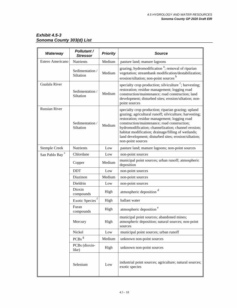
Exhibit 4.5-3 Sonoma County 303(d) List
Waterway Pollutant / Stressor Priority Source
Estero Americano Nutrients Medium pasture land; manure lagoons
Sedimentation / Siltation Medium
grazing; hydromodification a; removal of riparian vegetation; streambank modification/destabilization; erosion/siltation; non-point sources b
Gualala River
Sedimentation / Siltation Medium
specialty crop production; silviculture c; harvesting; restoration; residue management; logging road construction/maintenance; road construction; land development; disturbed sites; erosion/siltation; non-point sources
Russian River specialty crop production; riparian grazing; upland grazing; agricultural runoff; silviculture; harvesting; restoration; residue management; logging road
Sedimentation / Siltation Medium construction/maintenance; road construction;
hydromodification; channelization; channel erosion; habitat modification; drainage/filling of wetlands; land development; disturbed sites; erosion/siltation; non-point sources
Stemple Creek Nutrients Low pasture land; manure lagoons; non-point sources
San Pablo Bay c Chlordane Low non-point sources
Copper Medium municipal point sources; urban runoff; atmospheric deposition
DDT Low non-point sources Diazinon Medium non-point sources Dieldrin Low non-point sources Dioxin compounds High atmospheric deposition d
Exotic Species f High ballast water
Furan compounds High atmospheric deposition e
municipal point sources; abandoned mines; Mercury High atmospheric deposition; natural sources; non-point
sources Nickel Low municipal point sources; urban runoff
PCBs g Medium unknown non-point sources
PCBs (dioxinlike) High unknown non-point sources
Selenium Low industrial point sources; agriculture; natural sources; exotic species
4.5 - 18

c
4.5 HYDROLOGY AND WATER RESOURCES Sonoma County GP 2020 Draft EIR
Waterway Pollutant / Stressor Priority Source
Petaluma River Nutrients Medium Agriculture; land development; urban runoff Pathogens Medium Agriculture; land development; urban runoff Sedimentation / Siltation Medium Agriculture; land development; urban runoff
Sonoma Creek Nutrients Medium Agriculture; land development; urban runoff Pathogens Medium Agriculture; land development; urban runoff Sedimentation / Siltation Medium Agriculture; land development; urban runoff
a Hydromodification is any alteration of a stream channel.
b Non-point source pollution is discussed in Impact 4.5-1 Water Quality – Residential, Commercial, Industrial, and Public Uses.
Silviculture is a branch of forestry dealing with the development of forests.
d The Petaluma River and Sonoma Creek discharge to San Pablo Bay.
e Anthropogenic and/or natural sources release these compounds into the atmosphere. These compounds are later deposited on land and water.
f Exotic species disrupt natural benthos, change pollutant availability in food chain, and disrupt food availability to native species.
g Polychlorinated biphenyl fluids (PCBs) are used for heat transfer and electrical insulation properties and are common industrial contaminants. These materials, under certain fire or explosion situations can also produce the more toxic compounds of the dioxin family - the polychlorodioxins and polychlorofurans.
Sources: California 303 (d) List and TMDL Priority Schedule, State Water Resources Control Board, 1999 and 1998.
GROUNDWATER
During and after a storm event, rainfall may infiltrate into the ground surface, move downward through spaces between soil particles, and enter a zone of saturation. This zone of saturation is also referred to as groundwater and its replenishment by water moving downward is called groundwater recharge. Land areas vary widely in their recharge capability, depending on soil conditions and the underlying geology. In Sonoma County, rivers and stream corridors are important source areas for groundwater recharge, as are some upland areas underlain by permeable formations. A four-tier classification system is used to indicate general areas of groundwater availability: Class I is the major groundwater basins; Class II is major natural recharge areas; Class III is marginal groundwater availability areas; and Class IV is areas with low or highly variable water yield.
Groundwater is generally confined to geologic formations with high porosity or water-holding capacity called aquifers on a local scale, and groundwater basins on a regional scale. If aquifers are contiguous, groundwater can migrate between aquifers. In some cases, multiple aquifers occur, separated by less permeable or impermeable (clay) layers called aquacludes.
Much of Sonoma County is underlain by hard bedrock with low porosity. In these areas, groundwater is often only contained in large fractures in the rock. The capability to furnish water to wells is quite variable in these areas, depending on the degree and extent of rock fracturing, and the connectivity of fractures with each other and to recharge areas.
Groundwater is a vital source of water supply for both agricultural and urban uses in Sonoma County. In fact, Sonoma has the second largest number of wells of any county in California. Groundwater is
4.5 - 19
4.5 HYDROLOGY AND WATER RESOURCES Sonoma County GP 2020 Draft EIR
located and tapped by drilling wells into the zone of saturation. However, not all areas otherwise suitable for development have groundwater present in sufficient volume to meet the intended use of the well, have a reasonable rate of recharge, or have water of potable quality. The term safe yield is defined as “the maximum quantity of water which can be withdrawn annually from groundwater supply under a given set of conditions without causing an undesirable result”. Undesirable results include physical harm to the aquifer from consolidation, ground settlement, water quality problems from intrusion of less desirable water from other areas, interference with prior rights of others in adjacent groundwater areas, and declines in the water table. In some areas the quality and beneficial use of groundwater has been affected by contamination from leaking underground storage tanks or other pollutant sources. General groundwater availability issues found in portions of Sonoma County are discussed below.
Groundwater provides an important portion of the water supply for the cities of Sonoma, Sebastopol, Cotati, Rohnert Park, and Petaluma. The Valley of the Moon Water District and the Sonoma County Water Agency also rely on groundwater to supplement their water supply.
The most recent comprehensive scientific assessment of groundwater resources in Sonoma County was performed between 1975 and 1982 by the California Department of Water Resources (DWR) in cooperation with the SCWA. This assessment was conducted by performing a series of studies documented in DWR Bulletin 118-4. Although DWR was directed to update Bulletin 118 (including 118-4 for Sonoma County) by legislative authorization in the State’s Fiscal Year 1999 / 2000 Budget, this update was limited to a brief summary compilation of existing information due to State funding constraints. Given the changes in land use and population that have occurred over the past 30 years, information regarding groundwater resources in Sonoma County is outdated and may not represent current conditions.
Groundwater Issues
Decrease in Groundwater Recharge Rates
An increase in impervious surface area due to development, coupled with the increased use of groundwater resources, may have contributed to the decline of groundwater levels in several areas of the county. When impervious surfaces are placed over groundwater recharge areas, the percolation of surface water into the underlying water table is impaired and the surface water runs off, sometimes resulting in a decrease in groundwater recharge. Even in areas with high groundwater recharge rates, if the amount of groundwater extracted by local groundwater wells is greater than the amount of groundwater recharge, groundwater levels will gradually decline. When the rate of groundwater withdrawal exceeds the rate of recharge and occurs over a prolonged period of time, groundwater levels can drop dramatically and the aquifer may become overdrafted. In some cases, the decline in local groundwater levels has been such that groundwater wells must be lowered to maintain production levels or new wells drilled.
Lack of Groundwater Monitoring
Although it is clear that groundwater levels are dropping in several areas of the county, proper evaluation of groundwater level fluctuations and changes is difficult due to the scarce distribution of groundwater monitoring wells throughout the county. While some groundwater level data are available online at the State Department of Water Resources’ (DWR) Water Data Library, and from the US Geological Survey, the distribution of the monitoring wells is not adequate to assess the rate, extent, and severity of groundwater level fluctuations throughout the county.
4.5 - 20
4.5 HYDROLOGY AND WATER RESOURCES Sonoma County GP 2020 Draft EIR
Local Well Interference
Groundwater pumping from a well will lower local groundwater levels in the vicinity of the well. The affected area, called the cone of depression, is usually a cone-shaped lowering of the water table, within which the local aquifer is dewatered. The land area above the cone of depression is called the area of influence. If the cones of depression of two or more adjacent wells overlap, there is said to be well interference. Well interference can restrict water yield in these wells. Well pumping tests can be completed to assess the effects of a test well on existing adjacent wells.
Potential Groundwater Management Problem Areas
The historic use of groundwater resources in some areas of the county has resulted in a decline of the groundwater table. The significance of potential groundwater problems is unknown because of the lack of a countywide groundwater well monitoring network and a historic database. Preliminary identification of problem areas is based largely on anecdotal evidence, and reports from individual property owners to PRMD. Some of these problematic groundwater supply areas are currently being investigated by PRMD.
Groundwater Basins
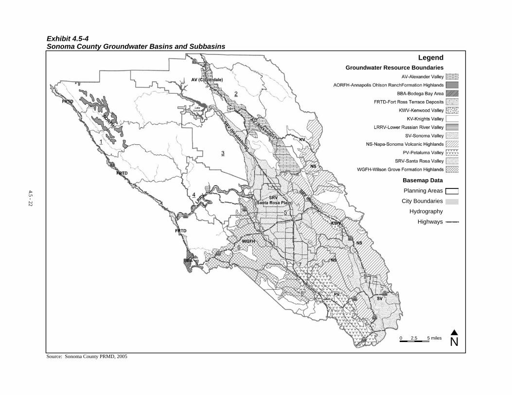
There are 11 separate groundwater basins in Sonoma County as portrayed in DWR Bulletin 118, which provides summaries of groundwater conditions throughout California. This Bulletin, first published in the early 1970’s, was updated in 2003. These basins, formed over geologic time under various conditions, vary in water availability, water quality, and recharge potential. In some cases, the groundwater basins have been divided into groundwater subbasins which have different hydrogeologic characteristics. The groundwater basins of Sonoma County as defined in DWR Bulletin 118 are discussed in this section. Exhibit 4.5-4 illustrates the location of each groundwater basin while Exhibit 4.5-5 summarizes each basin’s characteristics.
4.5 - 21
4.5 - 22
Exhibit 4.5-4 Sonoma County Groundwater Basins and Subbasins
Source: Sonoma County PRMD, 2005
Legend Groundwater Resource Boundaries
Basemap Data
Planning Areas
City Boundaries
Hydrography
Highways
0 2.5 5 miles N
4.5 HYDROLOGY AND WATER RESOURCES Sonoma County GP 2020 Draft EIR
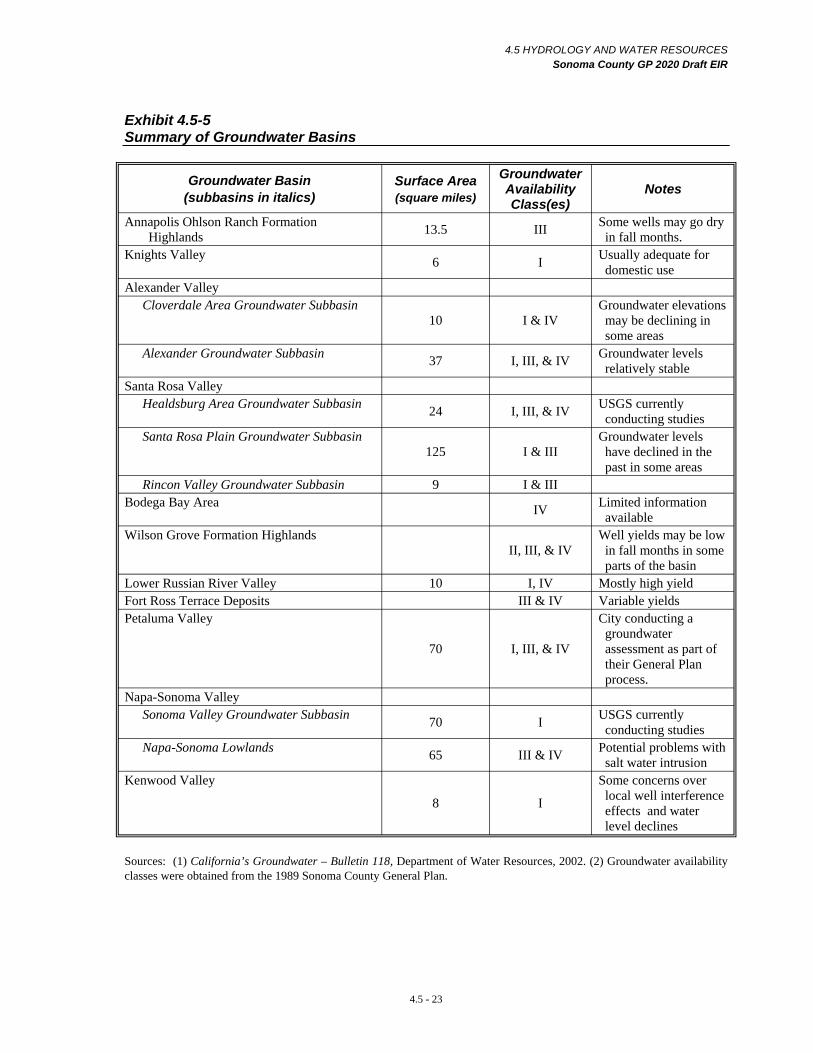
Exhibit 4.5-5 Summary of Groundwater Basins
Groundwater Basin (subbasins in italics)
Surface Area (square miles)
Groundwater Availability Class(es)
Notes
Annapolis Ohlson Ranch Formation Highlands 13.5 III Some wells may go dry
in fall months. Knights Valley 6 I Usually adequate for
domestic use Alexander Valley
Cloverdale Area Groundwater Subbasin 10 I & IV
Groundwater elevations may be declining in some areas
Alexander Groundwater Subbasin 37 I, III, & IV Groundwater levels relatively stable
Santa Rosa Valley Healdsburg Area Groundwater Subbasin 24 I, III, & IV USGS currently
conducting studies Santa Rosa Plain Groundwater Subbasin
125 I & III Groundwater levels have declined in the past in some areas
Rincon Valley Groundwater Subbasin 9 I & III Bodega Bay Area IV Limited information
available Wilson Grove Formation Highlands
II, III, & IV Well yields may be low in fall months in some parts of the basin
Lower Russian River Valley 10 I, IV Mostly high yield Fort Ross Terrace Deposits III & IV Variable yields Petaluma Valley
70 I, III, & IV
City conducting a groundwater assessment as part of their General Plan process.
Napa-Sonoma Valley Sonoma Valley Groundwater Subbasin 70 I USGS currently
conducting studies Napa-Sonoma Lowlands 65 III & IV Potential problems with
salt water intrusion Kenwood Valley
8 I
Some concerns over local well interference effects and water level declines
Sources: (1) California’s Groundwater – Bulletin 118, Department of Water Resources, 2002. (2) Groundwater availability classes were obtained from the 1989 Sonoma County General Plan.
4.5 - 23
4.5 HYDROLOGY AND WATER RESOURCES Sonoma County GP 2020 Draft EIR
Annapolis Ohlson Ranch Formation Highlands Groundwater Basin
The Annapolis Ohlson Ranch Formation Highlands (AORFH) groundwater basin, located in northwestern Sonoma County and surrounding the community of Annapolis, has a total surface area of approximately 13.5 square miles. The formation is defined by the areal extent of a group of disconnected, uplifted sedimentary deposits of the Ohlson Ranch Formation. This groundwater basin has been classified as a Class III groundwater area in the existing General Plan. Franciscan rocks, which surround the AORFH, are shown as groundwater availability Class IV. Generally only limited supplies of groundwater occur associated with fractures in these rocks, and in alluvial deposits of some small valleys along stream tributaries. The DWR Bulletin indicates that some wells located in the Ohlson Ranch Formation may go dry in fall months, especially following successive dry years.
Knights Valley Groundwater Basin
The Knights Valley (KV) groundwater basin, located just west of the Sonoma / Napa County line, has a surface area of roughly six square miles and extends from the confluence of Briggs Creek and McDonnel Creek to the small community of Kellogg. This basin has been classified as a Class I groundwater area. The valley bottom is also an important recharge area. Younger alluvium is the primary water-bearing unit of the basin. Well yields in the alluvium are usually adequate for most domestic uses.
Alexander Valley Groundwater Basin
The Alexander Valley (AV) Groundwater Basin has been divided into two separate subbasins: the Alexander subbasin to the south and the Cloverdale area subbasin to the north. A thin section of water-bearing materials marks the boundary between these two subbasins. The SCWA and the USGS are currently conducting a study to characterize groundwater conditions within this basin.
Cloverdale Area Groundwater Subbasin
The Cloverdale Area subbasin extends from Alderglen Springs and the small community of Preston in the north, to roughly two miles south of the town of Asti in the south. Cloverdale and Geyserville are located in this subbasin. Both obtain their water from well fields along the Russian River system. The subbasin extends over ten square miles and has a similar geologic composition to that of the Alexander subbasin, with the primary water-bearing units comprised of alluvium, the Glen Ellen Formation, and some areas of Sonoma Volcanics. The valley area is a Class I groundwater availability area, and the mountains to the east and west, (underlain by Franciscan Assemblage rocks) are a Class IV groundwater availability area. Two DWR groundwater monitoring wells in the vicinity of Cloverdale indicate that groundwater elevations in this subbasin may be declining.
Alexander Groundwater Subbasin
The Alexander subbasin occurs from about two miles south of Asti, to approximately five miles southeast of the small community of Jimtown. The subbasin has a surface area of 37 square miles and is comprised of a composite of late Tertiary to Quaternary age volcanic rocks and continental sedimentary deposits. The subbasin includes alluvium, the Glen Ellen Formation, and the Sonoma Volcanics. The upper half of this subbasin along the alluvial plain of the Russian River has been classified as a Class I groundwater availability area. The alluvial plain of the Russian River is a major recharge area for this subbasin. Mountainous areas adjacent to the lower half of the subbasin, south of the bend of the Russian River near the communities of Jimtown and Lytton, are classified as a Class III and Class IV groundwater area with variable well yields. A DWR groundwater monitoring well in the lower half of this subbasin indicates that groundwater levels are relatively stable in this area.
4.5 - 24
4.5 HYDROLOGY AND WATER RESOURCES Sonoma County GP 2020 Draft EIR
Santa Rosa Valley Groundwater Basin
The Santa Rosa Valley (SRV) groundwater basin has been divided into three separate subbasins: the Santa Rosa Plain Subbasin; the Rincon Subbasin; and the Healdsburg Area Subbasin. The Santa Rosa Plain Subbasin, the largest of the three subbasins, is separated from the Healdsburg Subbasin by the Russian River plain and from the Rincon Valley Subbasin by a narrow constriction formed in the bedrock of the Sonoma Volcanics. The subbasin adjoins the Petaluma Valley subbasin to the south, in the Penngrove area.
Healdsburg Area Groundwater Subbasin
The Healdsburg Area Subbasin is located northwest of the Santa Rosa Plain Subbasin and has a surface area of approximately 24 square miles. The subbasin is made up of alluvium, the Glen Ellen Formation, alluvial fan and terrace deposits, and the Wilson Grove Formation. The alluvium, comprised of unconsolidated permeable deposits of Holocene age, is found underlying the Russian River, Dry Creek, and other tributaries. These deposits produce a high yield, and are the primary source of water supply for the City of Healdsburg, which is located on major natural recharge areas of the subbasin. This subbasin has been characterized as a Class I groundwater area. The mountainous areas to the west and east of Healdsburg are groundwater availability Class IV areas, while the upland areas immediately surrounding Healdsburg to the north, northeast, and south are in groundwater availability Class III.
Santa Rosa Plain Groundwater Subbasin
The Santa Rosa Plain Subbasin has a total surface area of about 125 square miles. The Subbasin extends from the Cotati- Rohnert Park area to approximately one mile south of Healdsburg, and includes the greater Santa Rosa urban area.
The subbasin is composed of three water-bearing units: the Wilson Grove Formation (the principal water-bearing unit in the subbasin); the Glen Ellen Formation; and alluvium. The flat alluvial plain intersected by Santa Rosa Creek and its tributaries have been characterized as a Class I groundwater area. This area includes downtown Santa Rosa and Windsor, and is a major recharge area for the subbasin. The alluvial plain of the Laguna de Santa Rosa to the west is also a Class I area and a major groundwater recharge area. In the lower basin, groundwater availability is variable. Rohnert Park and Cotati are classified as Class I areas; the area near Penngrove as Class III; and the surrounding hillsides, including the slopes of the Sonoma Mountains as Class III. Urban growth in the Rohnert Park area during the 1970s and 1980s and the use of groundwater as a principal municipal water supply source have been associated with a historical decline in groundwater levels in the southern portion of the Santa Rosa Plain Subbasin. Water levels have stabilized somewhat since the early 1990s, with recharge and pumping currently thought to be in rough equilibrium. 5 In recent years, the City of Rohnert Park switched its primary source of municipal water supply from groundwater to water supplied by the SCWA. 6 The City of Rohnert Park continues to seek an increase in use of SCWA water in order to further reduce its reliance upon groundwater. A Water Supply Assessment
5 Groundwater Study for the Canon Manor West Subdivision Assessment District, Todd Engineers, June 2004.
6 City of Rohnert Park Draft Water Supply Assessment, Winzler & Kelly, October 2004.
4.5 - 25
4.5 HYDROLOGY AND WATER RESOURCES Sonoma County GP 2020 Draft EIR
recently completely by the City estimates that the combination of SCWA water and groundwater is sufficient to meet the needs projected in the City’s General Plan. 7
Rincon Valley Groundwater Subbasin
The Rincon Valley Subbasin has a surface area of approximately nine square miles. This subbasin is made up of two water-bearing units: the Glen Ellen Formation on the hillsides and alluvium. The Glen Ellen Formation is the major water source in the subbasin. This subbasin is isolated from the rest of the Santa Rosa subbasins by portions of the Sonoma Mountains, which are underlain by the Sonoma Volcanics. This subbasin is designated as a Class I groundwater area and a major natural recharge area, while the uplands bordering the valley are considered to be groundwater availability a Class III areas.
Bodega Bay Area Groundwater Basin
The Bodega Bay Area (BBA) groundwater basin is a coastal basin located in southwestern Sonoma County just north of the Marin / Sonoma County line.
The small community of Bodega Bay has an economy largely dependent upon fishing and tourism. Although the DWR has classified this area as being located within the Bodega Bay Groundwater Basin, information regarding this groundwater basin is limited. Groundwater is contained in generally thin terrace deposits and in fractures in the underlying Franciscan Assemblage rocks. The lack of a large storage volume in these aquifer materials limits the available water supply and subjects this area to water supply problems during successive dry years. Continued growth in areas of limited groundwater that also depends on groundwater can present supply problems to existing wells. In addition, the proximity of this basin to the ocean has lead to problems with saltwater intrusion.
Wilson Grove Formation Highlands Groundwater Basin
The Wilson Grove Formation Highlands (WGFH) groundwater basin is found along the border of Sonoma and Marin Counties. The formation was deposited in a marine environment onto the eroded surface of the underlying Franciscan Assemblage. Groundwater well yields in this basin are variable. Portions of western Sebastopol, Bloomfield, and Graton are located on Class II groundwater availability areas, while the remainder of the basin and adjacent areas where Franciscan Assemblage rocks occur at or near the surface have been characterized as Class III and Class IV areas. Anecdotal evidence indicates that the area surrounding Forestville is a groundwater deficient area, and well yields in this area may be problematic during fall months.
Lower Russian River Valley Groundwater Basin
The Lower Russian River Valley (LRRV) groundwater basin is a long, narrow, meandering groundwater basin that extends from the confluence of Mark West and Windsor Creeks, and the confluence of Porter Creek and the Russian River west to the community of Bridgehaven. The basin, with a surface area of about ten square miles, follows the Russian River corridor and is composed primarily of alluvium, ancient river terrace deposits, and river-channel deposits of Holocene age. Most wells in this groundwater basin produce high yields. This basin along the river valley has been classified as a Class I groundwater availability area, with most of the basin also being identified as an
City of Rohnert Park Draft Water Supply Assessment, Winzler & Kelly, October 2004.
4.5 - 26
7
4.5 HYDROLOGY AND WATER RESOURCES Sonoma County GP 2020 Draft EIR
area of relatively high natural groundwater recharge. Mountainous areas above the narrow river valley basin are classified as groundwater availability Class IV areas
Fort Ross Terrace Deposits Groundwater Basin
The Fort Ross Terrace Deposits (FRTD) Groundwater Basin is made up of a series of discontinuous marine terrace deposits along the Pacific coastline. The terrace deposits occur as a series of benches uplifted above sea level since the Pleistocene. Groundwater is contained in the often relatively thin marine terrace deposits, and in fractures in the bedrock formations that underlie the terrace materials. Sea Ranch is the largest community within this basin, but this area obtains most of its water supply from surface sources. Water yields in this groundwater basin are variable. The northern most portion of this basin is a Class III groundwater availability area, with the remainder of the basin considered to be a Class IV area.
Petaluma Valley Groundwater Basin
The Petaluma Valley (PV) Groundwater Basin covers an area of 70 square miles and is composed of sedimentary deposits of marine, continental, and volcanic derivation. Principal water bearing units in the basin consist of alluvium and the Wilson Grove Formation, located mainly along the northwest side of the Petaluma Valley. The alluvial deposits are of both Pleistocene and Holocene age, with the older alluvium being of greater importance, primarily in the northern portion of the Petaluma Valley. Water yields in the Wilson Grove Formation are moderate to very high. The Petaluma River alluvial plain areas have been classified as a Class I groundwater area, with the City of Petaluma located on the major natural recharge areas of the basin. The hillsides surrounding the alluvial plain are predominantly Class III to the east, in the Sonoma Mountains, and Class IV to the west, with limited groundwater contained in older consolidated sediments. Many of the upper watershed lands of the Petaluma basin are underlain by Sonoma Volcanics to the east, or Franciscan rocks to the west, and have limited groundwater resources.
Napa-Sonoma Valley Groundwater Basin
The Napa-Sonoma Valley Groundwater Basin has been divided into two subbasins: The Sonoma Valley Subbasin in Sonoma County; and the Napa-Sonoma Lowlands Subbasin in Napa County.
Sonoma Valley Groundwater Subbasin
The Sonoma Valley Subbasin is located in the southeastern corner of Sonoma County. The subbasin, extending over an area of 70 square miles, is composed of late Tertiary to Quaternary age volcanic rocks and continental sedimentary deposits. Water-bearing units in the subbasin include Sonoma Volcanics, the Glen Ellen Formation, the Huichica Formation, and alluvium. The heart of the subbasin, along the alluvial plain of Sonoma Creek and lower mud flats, are classified as Class I groundwater areas. Sonoma, Schellville, and Valley of the Moon are located in the recharge area of the subbasin. The SCWA and the USGS are conducting a four year study to characterize groundwater conditions within this subbasin.
Bennet Valley is located several miles south of Santa Rosa. Growth and vineyard development that uses groundwater may have strained the limited available water in this area.
Napa-Sonoma Lowlands Subbasin
The Napa-Sonoma Lowlands Subbasin is composed of 65 square miles immediately north of San Pablo Bay. This subbasin consists of the Sonoma Mountains that flank either side of the Sonoma and
4.5 - 27
4.5 HYDROLOGY AND WATER RESOURCES Sonoma County GP 2020 Draft EIR
Kenwood Valleys. The subbasin has two primary water-bearing formations: the Recent and Pleistocene Alluvial Deposits and the Pleistocene Huichica Formation. The alluvial deposits, consisting of poorly sorted clay, silt, and gravel, generally have low yields. This subbasin is mostly Class III and Class IV areas.
Kenwood Valley Groundwater Basin
The Kenwood Valley Groundwater Basin, located east of the Santa Rosa Valley and the City of Santa Rosa, has an area of eight square miles. The principal water-bearing units in this groundwater basin are Alluvium and the Glen Ellen Formation. This formation is tapped for domestic use by Kenwood and has been characterized as a Class I groundwater availability area, with Class III areas to the south.
Groundwater Areas of Concern
The following areas in the county were studied in a groundwater resources assessment report prepared by Kleinfelder Inc, for the Sonoma County PRMD. 8 As noted in the Kleinfelder report, these areas were selected for study through review of available literature and PRMD staff knowledge of likely areas of concern in the county with respect to groundwater.
West County / Joy Road
The West County / Joy Road area is a rural area located approximately ten to 15 miles west of the City of Santa Rosa. This area is not within an alluvial groundwater basin, as delineated by the DWR. The local geology is Franciscan Assemblage and Wilson Grove Formation rocks, and thus, groundwater-bearing characteristics can vary widely, but are commonly limited. Communities within and surrounding the West County / Joy Road area which may share common groundwater availability problems include Camp Meeker and Occidental to the northeast, Freestone to the southeast, and Bodega Bay to the south.
Mark West Springs / Rincon Valley
The Mark West Springs / Rincon Valley area is located in central Sonoma County, approximately three miles north of the City of Santa Rosa, in the vicinity of the community of Mark West Springs. The area appears to straddle two groundwater basins as delineated by the DWR: the upper Santa Rosa Valley - Rincon Valley Subbasin and the Napa - Sonoma Valley Basin.
Bennett Valley
Bennet Valley is located approximately three miles south of Santa Rosa. The area is located within the Napa – Sonoma Volcanics Groundwater Basin, but contains an alluvial aquifer. Growth and vineyard development that uses groundwater may have strained the limited available water in this area.
To address groundwater basin issues, the Sonoma County Board of Supervisors directed County staff to work with the USGS, the SCWA, and other local stakeholders to develop a cooperative study work program to systematically evaluate groundwater resources within the county’s major groundwater basins (the Sonoma Valley, Alexander Valley, Santa Rosa Plain, and the Petaluma Valley basins).
Summary of Findings, Water Resources Management Data Assessment, Sonoma County, California, Kleinfelder, Inc. 2001.
4.5 - 28
8
4.5 HYDROLOGY AND WATER RESOURCES Sonoma County GP 2020 Draft EIR
Groundwater Studies
The cooperative study is intended to enhance the current knowledge of groundwater resources within Sonoma County and to provide an objective, comprehensive, and scientifically based evaluation of groundwater conditions in the four major groundwater basins. More specifically, the program is intended to:
• Provide a general characterization of groundwater resources and demand for groundwater in significant groundwater basins within the county;
• Update DWR Bulletin 118-4 that describes general groundwater conditions in the largest groundwater basins within Sonoma County;
• Develop conceptual models for selected groundwater basins within the county that describe basin limits, regional aquifer groundwater yield and storage, areas of recharge and discharge, and regional groundwater quality;
• Develop computer models for selected groundwater basins that can be used as planning tools to:
à Assess the impacts of future groundwater use scenarios;
à Assist in evaluating the hydrogeologic and water quality impacts to due to changing land use;
à Estimate groundwater recharge; and
à Evaluate surface water and groundwater interaction.
• Identify regional areas where groundwater resources are (or in the future may be) threatened due to overdraft and / or poor water quality; and
• Evaluate the relationship between the significant groundwater basins within the county and with water supplies from the Russian River.
Hydrology and Water Resources – Regulatory Setting
Except for water quality issues, most of the regulations affecting water resources (both surface water and groundwater) are contained in the Sonoma County Code and related ordinances, with code enforcement by the PRMD. In many cases however, development and implementation of a local program or ordinance has been mandated by the State of California, or the federal government.
LOCAL REGULATIONS
County Grading Permits and Erosion Control
The Sonoma County Permit and Resource Management Department (PRMD) oversees grading activities in the county, enforcing the County’s grading requirements and erosion control provisions of
4.5 - 29

4.5 HYDROLOGY AND WATER RESOURCES Sonoma County GP 2020 Draft EIR
the Uniform Building Code (UBC), as well as other provisions of the County Code dealing with subdivision and land development. The Sonoma County Board of Supervisors is currently considering the need for a separate grading, erosion and sediment control, and drainage ordinance, although certain provisions of such an ordinance may be addressed in the existing County NPDES stormwater program requirements.
Submittal requirements for a grading permit issued by PRMD include site plans, existing and proposed contour changes, an estimate of the volume of earth to be moved, and soils and / or geotechnical reports. Projects involving grading activities may also require submittal of a drainage plan, especially where alterations to natural drainage ways are proposed or where the project is in a flood prone area. Drainage plans include supporting hydrologic and hydraulic calculations. Most grading activities are also subject to the County’s NPDES stormwater program requirements.
Grading permits are also required for most pond and reservoir construction where the SWRCB has authorized appropriation of water for agricultural, recreational, domestic, or other uses.
Vineyard Erosion and Sediment Control Ordinance (VESCO)
In June 1999 Sonoma County adopted a Vineyard Erosion and Sediment Control Ordinance or VESCO, (Article 5, Chapter 30 of the County Code). This ordinance is intended to address soil erosion problems from vineyard planting on steep slopes and erosion prone soils throughout the county. The ordinance requires growers who want to plant or replant a vineyard to notify the County Agricultural Commissioners Office. Three levels of planning and protection are included in the ordinance: Level I- implementation of basic measures for areas with less than 15 percent slopes or for highly erodible soils on slopes less than ten percent; Level II-submittal of a general erosion control plan for slopes over ten or 15 percent (depending on soil erodibility hazard); and Level III- submittal of detailed plans for vineyards proposed on slopes over 30 percent. The ordinance also includes setbacks from streams: 25 feet from top of bank for Level I and 50 feet for Level II and III plans. Setbacks from streams under VESCO cannot be less than stream setbacks required by the County General Plan. The ordinance generally precludes vineyard establishment on slopes over 50 percent. It does not address the planting of other crops, such as orchards or strawberries, on steep slopes. VESCO, as it relates to agricultural resources, is further discussed in Section 4.8 Agricultural and Timber Resources.
Flood Control and Floodplain Management
The County and all of the incorporated cities within the county are participants in the National Flood Insurance Program (NFIP) administered by the Federal Emergency Management Agency (FEMA). The NFIP, born out of the National Flood Insurance Act of 1968, is a voluntary program that aims to reduce future flood damage by adopting and enforcing floodplain management programs. The NFIP is comprised of three components: Flood Insurance Rate Maps (FIRMs); flood insurance; and floodplain management. The FEMA FIRMs identify flood plain hazard areas prone to flooding during major storm events. The FIRMs are used by insurance companies to set flood insurance rates and by local municipalities for implementing flood-control ordinances which govern new development.
Chapter 7B (Flood Damage Prevention Ordinance) of the Sonoma County Code discusses general and specific flood prevention standards to prevent flood damage within the county. Such measures apply to all structures or land constructed, located, extended, converted, or altered within special flood hazard areas in the county, as identified on the FEMA floodplain maps. The code section on Floodplain Management is based on the model FEMA program, and is focused on prevention of placement of fill, buildings and other obstructions in regulatory floodways (the zone along a channel
4.5 - 30
4.5 HYDROLOGY AND WATER RESOURCES Sonoma County GP 2020 Draft EIR
where flow moves with depth and velocity and where obstructions can cause the most damage) and on raising building elevations in floodplain areas to be above the 100-year flood.
A special provision of the Sonoma County floodplain management ordinance generally precludes the importation and placement of fill in unincorporated areas of the Laguna de Santa Rosa surrounding the cities of Rohnert Park and Cotati. The intent of this provision (termed no net fill) is to protect the natural floodplain storage functions of this area.
In spite of existing flood problems, implementation of Flood Hazard policies of the 1989 General Plan have likely reduced flooding and flood damage by limiting the extent and kind of new construction and other land activities in flood hazard areas identified by FEMA. Additionally, review of development projects with respect to impacts on flood flows and increase in peak runoff have resulted in appropriate mitigation and decreased the likelihood of increased flood hazards from new development. However, flooding and flood damage are still a major problem in Sonoma County.
The Sonoma County Water Agency was formed in 1949 with the primary responsibilities to produce and furnish water for beneficial uses, water conservation, and flood management. Nine geographical zones, each encompassing a major watershed, were proposed in 1958 as a means of financing the construction and maintenance of flood control works in the county. To date, eight of these zones were officially formed and six zones are currently active as shown in Exhibit 4.5-6. The agency works cooperatively with the incorporated cities, unincorporated communities, and the State and federal government to oversee flood control channel modifications and flood control revenue collection within the six active zones. The SCWA also conducts drainage investigations and develops and implements drainage and flood improvement plans for areas, often working cooperatively with cities to address drainage problems common to both incorporated and unincorporated areas within the Flood Control Zones.
The California Division of Safety of Dams has established specific requirements with respect to dam operation. The California Government Code requires dam operators to prepare emergency plans for dam failure and evacuation. The contingency plans are updated every two years and submitted to the State Office of Emergency Services for review and comment.
Incorporated cities are responsible for developing contingency plans for State-designated dams affecting incorporated areas. Sonoma County has the responsibility for developing emergency plans for State-designated dams affecting unincorporated areas within the county. SCWA also reviews development applications when referred from a city for projects within incorporated cities, for compliance with its Flood Control Design Criteria. This manual provides hydrologic and hydraulic analysis and design procedures, criteria, and standards for drainage and flood control projects.
4.5 - 31
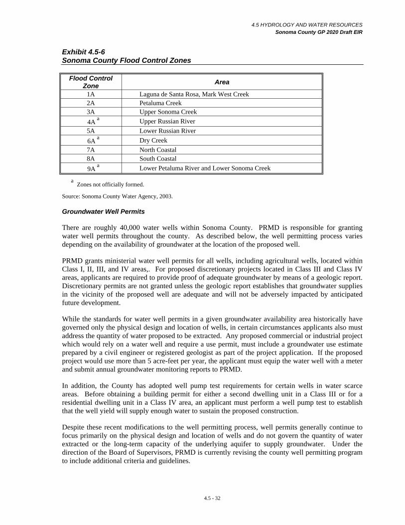
4.5 HYDROLOGY AND WATER RESOURCES Sonoma County GP 2020 Draft EIR
Exhibit 4.5-6 Sonoma County Flood Control Zones
Flood Control Zone Area
1A Laguna de Santa Rosa, Mark West Creek 2A Petaluma Creek 3A Upper Sonoma Creek 4A a Upper Russian River 5A Lower Russian River 6A a Dry Creek 7A North Coastal 8A South Coastal 9A a Lower Petaluma River and Lower Sonoma Creek
a Zones not officially formed.
Source: Sonoma County Water Agency, 2003.
Groundwater Well Permits
There are roughly 40,000 water wells within Sonoma County. PRMD is responsible for granting water well permits throughout the county. As described below, the well permitting process varies depending on the availability of groundwater at the location of the proposed well.
PRMD grants ministerial water well permits for all wells, including agricultural wells, located within Class I, II, III, and IV areas,. For proposed discretionary projects located in Class III and Class IV areas, applicants are required to provide proof of adequate groundwater by means of a geologic report. Discretionary permits are not granted unless the geologic report establishes that groundwater supplies in the vicinity of the proposed well are adequate and will not be adversely impacted by anticipated future development.
While the standards for water well permits in a given groundwater availability area historically have governed only the physical design and location of wells, in certain circumstances applicants also must address the quantity of water proposed to be extracted. Any proposed commercial or industrial project which would rely on a water well and require a use permit, must include a groundwater use estimate prepared by a civil engineer or registered geologist as part of the project application. If the proposed project would use more than 5 acre-feet per year, the applicant must equip the water well with a meter and submit annual groundwater monitoring reports to PRMD.
In addition, the County has adopted well pump test requirements for certain wells in water scarce areas. Before obtaining a building permit for either a second dwelling unit in a Class III or for a residential dwelling unit in a Class IV area, an applicant must perform a well pump test to establish that the well yield will supply enough water to sustain the proposed construction.
Despite these recent modifications to the well permitting process, well permits generally continue to focus primarily on the physical design and location of wells and do not govern the quantity of water extracted or the long-term capacity of the underlying aquifer to supply groundwater. Under the direction of the Board of Supervisors, PRMD is currently revising the county well permitting program to include additional criteria and guidelines.
4.5 - 32
4.5 HYDROLOGY AND WATER RESOURCES Sonoma County GP 2020 Draft EIR
STATE AND FEDERAL REGULATIONS
State and Federal Water Supply and Water Quality Regulations
The Environmental Protection Agency (EPA) is the federal entity in charge of establishing and enforcing fundamental water quality regulations in the United States. The EPA is also in charge of public health and the environment by setting standards for drinking water contaminants and protecting sources of drinking water under the Safe Drinking Water Act of 1974. The EPA develops minimum standards and the states then develop individual programs that best meet their unique needs, consistent with or exceeding the federal minimum standards. The EPA is also responsible for monitoring state adherence to the minimum federal standards.
California has a separate Water Code that provides details on the programs, regulations, and procedures for the development, protection, use, and management of the State’s water resources. With the passage of the Porter-Cologne Water Quality Control Act by the State of California in 1969, the State Water Resources Control Board (SWRCB) and the nine Regional Water Quality Control Boards (RWQCBs) became the principal State agencies with responsibility for the coordination and control of water quality. Per the Water Code, the SWRCB is generally responsible for setting statewide water quality policy and is solely responsible for the allocation or determination of surface water rights. The RWQCBs are responsible for water quality planning and regulatory decisions for their respective regions. Sonoma County is located within the jurisdiction of two RWQCBs: the North Coast (Region 1) RWQCB, and the San Francisco Bay (Region 2) RWQCB, which includes the Petaluma River and Sonoma Creek. The RWQCBs have the authority to implement water quality protection standards through the issuance of permits for discharges to waters at locations within their respective jurisdictions. Their jurisdiction also extends to discharge of wastes and wastewater to land, and to land disturbance, if the activities could affect the beneficial uses of surface water or groundwater.
Regulation of public drinking water supply, including the protection of supply source areas, and monitoring and assessment to insure that an adequate municipal or public supply is provided and managed for health and safety, is under the jurisdiction of the State Department of Health Services (DHS). Under California Water Code section 350, DHS can direct that a water supplier (both public and private) declare a water supply emergency, either on a short term basis, during an extended drought, or on a long term basis, where there is evidence that the available water supply may not be able to meet existing public needs, especially for drinking water, sanitation, and fire protection. In these situations, moratoria on new public water connections may be ordered until an adequate supply is insured. Currently there are no such water supply impairment declarations or water supply emergencies in Sonoma County.
The State Department of Water Resources (DWR) is the State agency responsible for managing California’s water resources other than water quality, including conducting technical studies of surface water and groundwater in cooperation with local agencies, overseeing certain flood prevention and floodplain management programs, and developing and implementing water conservation and efficient water use strategies and programs in cooperation with local agencies. DWR is also responsible for building, operating, and maintaining the State Water Project, which supplies drinking water and agricultural irrigation water to various parts of the state, but not to Sonoma County. DWR has also been given the responsibility for overseeing the preparation of Groundwater Management Plans.
NPDES Program
The SWRCB and the nine RWQCBs implement the State and federal clean water laws, including the National Pollutant Discharge Elimination System (NPDES) permitting process. The program
4.5 - 33

4.5 HYDROLOGY AND WATER RESOURCES Sonoma County GP 2020 Draft EIR
regulates point sources discharges from industrial, municipal, and other facilities if their discharges go directly to surface waters. In 1987, the NPDES program also began a phased approach to addressing non-point source pollution from streets, parking lots, construction sites, homes, businesses and other sources.
Under Phase I of the NPDES stormwater program, all medium separate storm sewer systems (serving a population of 100,000 – 249,000) and large separate storm sewer systems (serving a population of 250,000 or more) were required to obtain a municipal permit. Under Phase II of the NPDES program, small storm sewer systems are also required to obtain coverage under a Regional Board-issued permit as of August 8, 2003. A small storm sewer system is defined as any unpermitted municipal separate storm sewer system located in an urbanized area with a population of 50,000 and a population density of 1,000 per square mile. In Sonoma County, the City of Santa Rosa and unincorporated urban areas surrounding Santa Rosa are part of the Phase I NPDES stormwater program area. All of the cities except Cloverdale and the unincorporated urban areas surrounding Petaluma and Sonoma are in the Phase II program.
Sonoma County, the SCWA, and the City of Santa Rosa have been issued a joint NPDES Phase 1 Municipal Stormwater Permit by the North Coast RWQCB. The permit, renewed every five years, requires the permittees to develop and implement programs to protect stormwater quality. Programs focus on public and private construction, municipal operations, illicit discharge detection and elimination, public education, and post development stormwater controls. The Phase I Program, which originally covered the City of Santa Rosa and adjacent urban areas, was expanded under Phase II to cover a much larger portion of the unincorporated area around Santa Rosa. Other NPDES Phase II areas include urban areas within and surrounding Rohnert Park, Cotati, Sebastopol, Healdsburg, Windsor, Petaluma and Sonoma. The County and the SCWA are copermittees under the Phase II general permit for unincorporated areas in Sonoma Valley and Penngrove which are under the jurisdiction of the San Francisco Bay RWQCB. Programs similar to the Phase 1 activities are implemented in these areas. The County is responsible for Phase II program development and management in unincorporated areas.
The NPDES program is the basis for the County’s Storm Water Quality Ordinance (Ordinance Number 4981). Violations are considered misdemeanors and public nuisances and may be subject to court orders, fines, and reimbursement of County costs and damages.
The NPDES permit program also affects construction sites that disturb one acre or more. Under the Phase I NPDES stormwater program, construction sites that are larger than five acres were required to obtain a General Construction Activity Stormwater Permit. Under the Phase II NPDES program, which went into effect on March 10, 2003, construction sites disturbing between one and five acres of land are also required to obtain coverage under the General Construction Activity Stormwater Permit. Permit applicants are required to prepare a Stormwater Pollution Prevention Plan (SWPPP), implement construction-related BMPs, monitor discharges, and implement post-construction BMPs. Typical construction BMPs include temporary soil stabilization measures (e.g., mulching, seeding); storing materials and equipment to ensure that spills or leaks cannot enter the storm drain system or storm water; and using filtering mechanisms at drop inlets to prevent contaminants from entering storm drains. Typical post-construction management practices include street sweeping and cleaning of stormwater inlet structures.
In June 2005, the County, the SCWA, and the City of Santa Rosa adopted a joint agency Standard Urban Stormwater Mitigation Plan (SUSMP). The SUSMP is a requirement of both the NPDES Phase I and Phase II permits. The SUSMP applies to applicable projects within the unincorporated and urbanized areas surrounding the Cities of Santa Rosa, Petaluma, and Sonoma.
4.5 - 34
4.5 HYDROLOGY AND WATER RESOURCES Sonoma County GP 2020 Draft EIR
SUSMP substantially changed development practices by requiring applicable projects to design and implement post-development measures to reduce stormwater pollution. Prior to SUSMP, projects were designed to improve site drainage and to prevent flooding. Under SUSMP, project plans now need to include water quality design improvements that will, to the maximum extent practicable, prevent or reduce pollution that is generated on-site before being carried off-site in stormwater runoff. The SUSMP has several key objectives: to minimize and / or retain natural absorption and purification of stormwater by soil and surface vegetation; prevent erosion in creek channels; protect sensitive aquatic areas; prevent increases in pollutants to creeks, especially pollutants listed as impairing local creeks; and prevent the discharge of non-stormwater discharges to storm drain systems.
TMDL Program
In addition to the NPDES program, the RWQCBs also implement the federally-mandated Total Maximum Daily Load (TMDL) program for each of the watersheds. The term TMDL is used by the RWQCBs and the EPA to identify, on a stream-specific basis, pollutant limitation standards. Resource and regulatory agency staff use the term TMDL to refer to both the definition of the regulation and the planning process to achieve compliance, as well as the actual pollutant standard.
The technical definition of a TMDL is the “sum of the individual wasteload allocations for point sources, load allocations for non-point sources and natural background pollutants, and an appropriate margin of safety.” As a process, TMDLs serve to identify impaired water bodies, determine the sources for this impairment, and implement mitigation measures to reduce those sources and remove impairments. This process has several formal steps including Problem Statement, Source Allocation, and Implementation Plan development. Public input and comment is sought at each of these steps.
The TMDL document is a written, quantitative assessment of water quality problems and contributing pollutant sources. It specifies the amount of pollution reduction necessary to meet water quality standards, allocates the necessary pollutant limits among the various sources in the watershed, and provides a basis for taking actions needed to restore a waterbody. TMDLs range from ten to over 100 pages in length, depending on the complexity of the issues. The goal of a TMDL is to attain water quality standards.
In Sonoma County, TMDLs have been completed for the Gualala River and are well underway for Sonoma Creek, and the Russian River and its major tributaires. The RWQCB is in the early planning stages for development of TMDLS for the Petaluma River and most of the coastal streams.
Watershed Management Planning and Regulation
The water resource protection efforts of the SWRCB and the RWQCBs are guided by the Watershed Management Initiative (WMI). The WMI is designed to integrate various surface and groundwater regulatory programs while promoting cooperative, collaborative efforts by various agencies and interest groups within a watershed. The WMI takes a watershed management approach for water resources protection by integrating point and non-point source discharges, ground and surface water interactions, and water quality/water quantity relationships. The SWRCB has worked with each individual RWQCB in identifying the major watersheds in each region, prioritizing water quality issues, and developing watershed management policies focused on protecting beneficial uses of water. In Sonoma County, the San Francisco Bay RWQCB has jurisdiction over the Sonoma Creek and Petaluma River watersheds and the North Coast RWQCB has jurisdiction over the Gualala River and Russian River watersheds and their tributaries, as well as a number of small watersheds along the coast.
4.5 - 35
4.5 HYDROLOGY AND WATER RESOURCES Sonoma County GP 2020 Draft EIR
As described above, Section 303(d) of the Federal Clean Water Act, also implemented primarily by the RWQCBs, requires that each state establish Total Maximum Daily Loads (TMDLs) for all waters that are not attaining water quality standards set forth by the EPA (termed impaired water bodies). The TMDL must account for all sources of the pollutants that caused the water to be listed as impaired (e.g., sediment, nutrients, and / or pathogens) and must be established at the level necessary to implement the applicable water quality standards. A discussion of impaired water bodies (creeks and rivers) in Sonoma County is included in the discussion of watersheds and subbasins, above.
Beyond the WMI, Phase II NPDES stormwater management, and TMDL Regional Board managed water quality programs, there is currently no State mandate or County requirement to prepare more general or integrated Watershed Management Plans for large (basin scale) watersheds. However, under Section 64655, of Article 7, Chapter 17 of the California Code of Regulations, the Department of Health Services (DHS), in cooperation with local water suppliers, must complete a Watershed Sanitary Survey for all public water systems that have a surface water source. The Watershed Sanitary Surveys must include information on the physical characteristics of the watershed, identify possible sources or activities which could impact drinking water quality, and include recommendations for management measures and corrective actions. Watershed Sanitary Surveys have been completed for all of the watersheds upstream of surface water supply systems and are on file at the DHS Santa Rosa office.
In addition, local governments that provide or maintain within their boundaries underground drinking water supplies are responsible for developing wellhead protection programs. Wellhead protection programs (including local ordinances and land use control programs for lands immediately surrounding public water supply wells) focus on preventing groundwater drinking water supplies from being contaminated. In Sonoma County, the City of Sebastopol has developed a Wellhead Protection Program which was implemented in coordination with and overseen by the DHS.
A number of more general watershed management plans have been prepared for individual watersheds in Sonoma County. These have typically been prepared by local Resource Conservation Districts (RCDs) in cooperation with local stakeholder groups such as watershed councils, and interest groups such as the Farm Bureau and other agricultural associations and environmental groups. Plans have been prepared for the Petaluma River Watershed, the Sonoma Creek Watershed, and the Stemple Creek Watershed. These plans inventory and identify watershed management problems, such as upland erosion and gullying, stream bank failure areas, and areas of sensitive biological resources (often along creeks), and note areas needing restoration and enhancement. The plans also outline general watershed management goals and objectives, and include recommendations and priorities for tackling identified problems and management needs.
Although RCD authored Watershed Management Plans have no binding legal authority for enforcement or for implementation of their management recommendations, they are valuable in that they provide a framework for setting priorities, and contain an action plan and management strategies. They often serve as a vehicle for attracting follow up State and federal grant funding for implementing specific projects identified in the plans. The Sonoma Ecology Center, acting with the Southern Sonoma Resource Conservation District has been especially successful in developing and implementing projects in the Sonoma Creek watershed.
Plans have also been prepared for the Petaluma River, Santa Rosa Creek, and the Laguna de Santa Rosa by the cities of Petaluma, Santa Rosa, and Sebastopol in cooperation with creek protection and enhancement by non-profit interest groups. These plans focus on protection and enhancement of the immediate creek corridor. Individual restoration, enhancement, and public access projects have been implemented along portions of all of these creeks.
4.5 - 36
4.5 HYDROLOGY AND WATER RESOURCES Sonoma County GP 2020 Draft EIR
More comprehensive assessments and management plans are under preparation for the Russian River, for the Gualala River, for the Laguna de Santa Rosa, and for the agricultural and open space lands around San Pablo Bay in southern Sonoma County. These are large, multi-year planning efforts that involve many local, State and federal government agencies and interest groups, with overall plan coordination for several of the watershed planning efforts by the Army Corps of Engineers, often in association with the State Coastal Conservancy. These plans and assessments focus on protection of biological resources and fisheries, including endangered species, and will include actions for waterway and wetlands restoration and enhancement. Most of the implementation recommendations will require the voluntary cooperation of private property owners and local government, although funding can come from the federal and state governments.
In addition to larger watershed and stream corridor planning efforts, a number of local environmental interest groups (urban creeks councils and friends of creeks) complete creek inventories and monitor water quality, and sponsor creek clean up days, and local creek restoration and planting programs. The Atascadero and Green Valley Creek Watershed Council is an example of an active non-profit environmental restoration group in the Green Valley watershed area of Forestville and Sebastopol. The Laguna Foundation in Sebastopol is also very active in the preservation, protection, and enhancement of the Laguna de Santa Rosa, as is the Committee for the Restoration of Santa Rosa Creek, in the Santa Rosa area.
Groundwater Management
In California, surface water rights are regulated by the State, while groundwater is managed by a variety of local entities with a wide array of regulatory authority. Most local governments require well permits that primarily address groundwater quality issues and well construction requirements associated with groundwater. Historically, very few local governments, particularly counties, regulate or manage groundwater usage or withdrawals in order to broadly manage these water resources.
Generally, five methods for groundwater management have evolved over time. Groundwater management can be achieved by one of the following entities or methods.
Local Agencies
More than 20 types of local agencies are authorized by the California Water Code to provide water for various beneficial purposes. Many of these agencies also have statutory authority to institute some form of groundwater management. Most of these agencies are identified in the Water Code, but their specific authority related to groundwater management varies. These types of agencies include: Community Services Districts; County Sanitation Districts; County Service Areas; County Water Authorities; County Water Districts; County Water Works Districts; Flood Control and Water Conservation Districts; Irrigation Districts; Metropolitan Water Districts; Municipal Utility Districts; Municipal Water Districts; Public Utility Districts; Reclamation Districts; Recreation and Park Districts; Resort Improvement Districts; Resource Conservation Districts; Water Conservation Districts; Water Districts; Water Replenishment Districts; and Water Storage Districts.
Although the County has the authority to initiate groundwater management, it does not have authority over the above agencies. However, the County could provide management in some areas through its various special water supply, or wastewater districts. The SCWA could also develop and implement groundwater management plans under AB 3030.
4.5 - 37
4.5 HYDROLOGY AND WATER RESOURCES Sonoma County GP 2020 Draft EIR
Groundwater Adjudication
Another form of groundwater management in California is through court adjudication. The groundwater rights of all overlying property owners and appropriators are determined by the court in basins where a lawsuit is brought to adjudicate the basin. The court also decides who the extractors are; how much groundwater those well owners can extract; and who the Watermaster will be to ensure that the basin is managed in accordance with the court's decree. The Watermaster must report periodically to the court. Such adjudications are difficult to achieve, costly, time consuming, and divisive. There are 19 adjudicated groundwater basins in California, none of which are located in Sonoma County.
Groundwater Management Agencies
Thirteen groundwater management agencies have been directly authorized by special State legislation. These entities vary significantly in why they were created, how they are managed, and what authorities are granted in each case. Many agencies or districts are authorized to influence or regulate groundwater extraction directly. Most agencies can establish zones of benefit and levy fees on groundwater extraction. Still others are primarily focused on groundwater monitoring or water quality management.
Several other established water districts have special legislative authority to manage groundwater actively, and, in certain circumstances, to levy an extraction charge on groundwater use. The SCWA is a Special Water District, but it does not have special legislative authority to manage groundwater.
Local Groundwater Ordinance
Groundwater management is also achieved through local groundwater ordinances. More than 27 counties have adopted groundwater ordinances and other counties are considering doing so. The objectives of these ordinances vary, but many are intended to prevent groundwater from being exported outside the boundaries of the counties of origin. The authority of counties to regulate groundwater has been legally challenged. In 1995, the California Supreme Court declined to review a lower court decision (Baldwin vs. Tehama County) which holds that State law does not occupy the field of groundwater management and therefore does not prevent cities and counties from adopting ordinances to manage groundwater under their police powers. However, the precise nature and extent of the police power of cities and counties to regulate groundwater is uncertain. To exercise these police powers, findings would have to be made regarding public health safety and welfare.
Although Sonoma County does not have an existing groundwater management ordinance, it does have a limited well ordinance which accomplishes some of the same regulatory functions on a more geographically limited basis. Mendocino and Napa Counties have groundwater ordinances.
AB 3030 Groundwater Management Plans
In 1992, the State passed AB 3030 (and later amended it in SB 1938) which provides authority for local water agencies to adopt groundwater management plans if certain procedures are followed. These plans can involve collaboration among numerous agencies and thus offer opportunities for local governments to participate in groundwater management planning in cooperation with water providers. No new level of government is formed under AB3030 and action is voluntary rather than mandatory. The plan is only prepared following a public hearing and the adoption of a resolution. After the plan is prepared, a second hearing is required to determine whether to adopt the plan, and if there is no majority of opposition, the plan can be adopted within 35 days after the second hearing. If the majority is opposed, the groundwater management plan can not be adopted and no new plan may be
4.5 - 38
4.5 HYDROLOGY AND WATER RESOURCES Sonoma County GP 2020 Draft EIR
adopted for one year. Once the plan is adopted, rules and regulations must be developed to implement it. Many plans that have been adopted are relatively simple and define groundwater basin boundaries for monitoring purposes. The Water Code also provides the local water supplier with the powers of a Water Replenishment District in order to raise revenue to pay for facilities used for basin management (including extraction, recharge, conveyance, and water quality).
The Water Code also provides that a groundwater management plan may include any one or all of the following technical components:
• Control of saline water intrusion,
• Identification and management of wellhead protection areas and recharge areas,
• Regulation of the migration of contaminated groundwater,
• Administration of a well abandonment and well destruction program,
• Mitigation of conditions of overdraft,
• Replenishment of groundwater extracted by water suppliers,
• Monitoring of groundwater levels and storage,
• Facilitating conjunctive use operations,
• Identification of well construction policies,
• Construction and operation by the local water suppliers of groundwater contamination cleanup, recharge, storage, conservation, water recycling and extraction projects,
• Development of relationships with State and federal regulatory agencies, or
• Review of land use plans and coordination with land use planning agencies to assess activities which create a reasonable risk of groundwater contamination. 9
There are no adopted groundwater management plans in Sonoma County. Recently however, the SCWA Board directed the General Manager / Chief Engineer to prepare a work plan for Board consideration detailing the steps necessary to develop a groundwater management plan under AB 3030 for the Sonoma Valley. The work plan will consider methods to increase the availability of Russian River water or provide recycled water for vineyard irrigation so that current municipal and agricultural groundwater pumping can be reduced.
Additionally, in 2001, the SCWA and USGS initiated a four-year study of the Sonoma Valley and Alexander Valley groundwater basins. The preliminary results of the study indicate that the Sonoma Valley Groundwater Basin is limited in its water-bearing capacity due to its geology and the relatively small size of the basin. In addition, the basin is bounded to the south by saline water (i.e., the San Pablo Bay) which could intrude into the basin. Although there do not appear to be regional overdraft
AB 3030 (California Water Code Section 10750 et seq.)
4.5 - 39
9
4.5 HYDROLOGY AND WATER RESOURCES Sonoma County GP 2020 Draft EIR
issues, there are indications of localized water level declines. The basin is vulnerable to potential water quality degradation from saline water intrusion and localized overdraft if conditions are not carefully monitored or managed in the future given the increasing significance of groundwater for meeting domestic, municipal, and agricultural water supply demands in the Sonoma Valley.
Based on these issues, groundwater management could be a method to help ensure a reliable water supply in Sonoma County.
Hydrology and Water Resources – Significance Criteria
According to the State CEQA Guidelines, the project would have a significant hydrology and water resources impact if it would:
• Violate any water quality standards or waste discharge requirements;
• Otherwise substantially degrade water quality;
• Substantially deplete groundwater supplies or interfere substantially with groundwater recharge such that there would be a net deficit in aquifer volume or a lowering of the local groundwater table level (e.g., the production rate of pre-existing nearby wells would drop to a level which would not support existing land uses or planned uses for which permits have been granted);
• Substantially alter the existing drainage pattern of the site or area, including through the alteration of the course of a stream or river, in a manner which would result in substantial erosion or siltation on- or off-site;
• Substantially alter the existing drainage pattern of the site or area, including through the alteration of the course of a stream or river, or substantially increase the rate or amount of surface runoff in a manner which would result in flooding on- or off-site;
• Create or contribute runoff water which would exceed the capacity of existing or planned storm water drainage systems or provide substantial additional sources of polluted runoff;
• Require or result in the construction of new storm water drainage facilities or expansion of existing facilities, the construction of which could cause significant environmental effects;
• Place housing within a 100-year flood hazard area as mapped on a federal Flood Hazard Boundary or Flood Insurance Rate Map or other flood hazard delineation map;
• Place within a 100-year flood hazard area structures which would impede or redirect flood flows;
• Expose people or structures to a significant risk of loss, injury, or death involving flooding, including flooding as a result of the failure of a levee or dam;
• Inundation by seiche, tsunami, or mudflow. (Potential impacts of inundation by seiche, tsunami, or mudflow are discussed in Section 4.7 Geology / Soils.)
4.5 - 40
4.5 HYDROLOGY AND WATER RESOURCES Sonoma County GP 2020 Draft EIR
Hydrology and Water Resources – Impacts and Mitigation Measures
WATER QUALITY
Impact 4.5-1 Water Quality – Residential, Commercial, Industrial, and Public Uses Residential, commercial, industrial, and public uses consistent with the Draft GP 2020 could introduce additional non-point source pollutants to downstream surface waters. However, existing regulations and water quality policies and programs contained in the Draft GP 2020 would reduce this to a less-than-significant impact. (LTS)
Most of the major streams in the county have been characterized as impaired, and at times, in violation of water quality standards listed in the Basin Plans for one or more pollutants, mainly sediment, nutrients, pathogens and, in some areas, elevated temperature. While many of the pollutants that have impaired Sonoma County’s water bodies can be attributed to historical agricultural practices and similar land uses, runoff from development in the unincorporated area has contributed to water quality degradation. Continued impairment of water quality could potentially threaten adopted water quality standards and the beneficial uses of water bodies, as defined by the RWQCBs in the Basin Plans for the North Coast and San Francisco Bay areas.
Development and maintenance of land uses such as residential, commercial, industrial, and public facilities (e.g., roads, schools, energy generation and wastewater facilities) creates additional impervious surfaces and automobile use. Additionally, this development can result in the use of materials that can impair water quality such as fertilizers and pesticides (e.g., for landscaping) and toxic chemicals (e.g., for industrial uses or energy production). Water, typically as rainfall, moves over these impervious surfaces where it picks up and carries away natural (e.g., sediment) and human-made pollutants (e.g., oil, pesticides, etc.) and deposits them into streams, rivers, wetlands, and eventually coastal waters. Runoff from these uses is one component of water pollution known as non-point source pollution (i.e., having many diffuse sources).
Several different types of pollutants, including sediment, organic compounds, nutrients, trace metals, bacteria and viruses, and oil and grease compounds, are common in runoff from these uses. Sediment sources include roads and parking lots, as well as destabilized landscape areas, stream banks, unprotected slopes and denuded or disturbed areas. Sediment also transports pollutants such as trace metals, nutrients, and hydrocarbons that attach to each particle. Organic compounds are derived from automotive fluids, pesticides, and herbicides. Nutrients include nitrogen, phosphorus, and other organic compounds that can be found in organic litter, fertilizers, food waste, sewage, and sediment. Sources of trace metals include motor vehicles, roofing and construction materials, and chemicals. Animal wastes, sanitary sewer overflow, and trash handling areas can contribute bacteria and viruses. Sources of oil and grease compounds include motor vehicles, food service establishments, and fueling stations. Water quality impacts related to soil erosion and sedimentation are discussed in Impact 4.5-2 Water Quality – Soil Erosion and Sedimentation Related to Construction.
Increased growth would increase urbanization and the conversion of vacant open lands to areas with increased impervious surface area. As the Draft GP 2020 employs an urban centered growth strategy, its implementation would result in an increase in urban-type development in the unincorporated area mostly within either the unincorporated USAs or within the unincorporated portion of the USAs of the county’s nine cities. However, some increase in residential, commercial, industrial, and public uses would also take place in rural areas.
4.5 - 41
4.5 HYDROLOGY AND WATER RESOURCES Sonoma County GP 2020 Draft EIR
Such development would result in an increase in pollutants associated with runoff as described above. Therefore, the water quality of streams within or adjacent to either the unincorporated USAs or within the unincorporated portions of the USAs of the nine cities would likely be further degraded by urban land use activities. In general, the coastal communities and smaller isolated rural communities would be expected to experience the least amount of population increase. Therefore, the majority of coastal streams would experience relatively less adverse changes to water quality resulting from implementation of the Draft GP 2020.
As described in the setting section, the NPDES Phase I and II stormwater permitting programs regulate municipal storm drain systems, industrial facilities, and construction sites. Under the NPDES permitting program, the preparation and implementation of Stormwater Pollution Prevention Plans (SWPPPs) are required for construction activities. Project applicants may also be required (depending on the nature of the project) to develop a long-term SWPPP or a long-term Stormwater Management Program (SWMP) to cover potential storm water pollution associated with site development after construction. The long-term SWPPP and / or SWMP must identify potential sources of pollution that may be reasonably expected to affect the quality of stormwater discharges as well as identify and implement BMPs that ensure the reduction of these pollutants during stormwater discharges. For most commercial and residential development, the NPDES program requirements apply only to storm water pollutants within runoff during construction activities. The program does not require long-term water quality BMPs upon project completion.
The Draft GP 2020 Water Resources Element contains several policies designed to protect and improve water quality in the unincorporated area. Many of the policies focus on fostering better communication and coordination among all of the agencies and interest groups that have a role in water quality management. Public education and cooperation between the public, stakeholders, and interest groups in developing County-specific management actions and the implementation of State- and federally-mandated water quality protection programs (such as NPDES stormwater and TMDLs) are of primary importance. In general, the Draft GP 2020 policies would help to ensure that future urban-type development does not result in an increased violation of water quality standards.
Policy WR-1a would call for coordination between the County and regulatory agencies, municipal districts, and stakeholders to develop and implement public education and technical assistance programs. Such programs would educate the public about water quality problems and how their actions have a direct impact on water quality. In addition, education programs would inform the public as to what is currently being done by the County to improve stormwater management water quality while recommending water quality BMPs that can be implemented by the general public.
Policy WR-1b would reduce sediment and other pollutants in site runoff from County properties, buildings, and facilities, through the preparation and implementation of a BMP manual for the construction and maintenance of these areas. Similarly, Policy WR-1g could lead to new stormwater management regulations in addition to the various existing stormwater, grading, and erosion control regulations. Such regulations would minimize the deposition and discharge of sediment, debris, waste, and other pollutants into surface runoff, drainage systems, and surface water bodies.
Policies WR-1c, WR-1d, WR-1e, and WR-1f would also seek to protect water quality by means of coordination with regulatory agencies (i.e., the RWQCB). Policy WR-1c would work towards the development and implementation of new stormwater management regulations applicable to new development and redevelopment in unincorporated areas. Policy WR-1c would prioritize stormwater management efforts, focusing first on urbanizing watersheds and watersheds with impaired water bodies. Policy WR-1c, in conjunction with Policy WR-1f, would result in the development and implementation of water quality plans and measures. Policy WR-1d would require that the County
4.5 - 42
4.5 HYDROLOGY AND WATER RESOURCES Sonoma County GP 2020 Draft EIR
support the RWQCB waste discharge requirements for all wastewater systems and point sources. Policy WR-1e would focus on coordination with the RWQCB in the development of TMDLs as well as the implementation of measures consistent with TMDL requirements.
Policy WR-1j would require the County to seek opportunities for water quality restoration and remediation where water quality is a concern. This policy could potentially involve stream restoration and / or the construction of engineered wetlands.
Policies OSRC-8a through OSRC-8h of the Open Space and Resource Conservation Element would substantially increase protection for riparian corridors. This added protection would provide increased filtration of pollutants, including sediment, before they reached the county’s stream channels. Such protection would further reduce water quality impacts from these land uses.
Adoption and implementation of the proposed policies and programs in the Draft GP 2020, combined with current stormwater, grading, and erosion control regulations, would ensure that the impact to water quality resulting from residential, commercial, industrial and public uses consistent with the Draft GP 2020 would be reduced a less-than-significant level.
Mitigation Measure 4.5-1 None Required.
Impact 4.5-2 Water Quality – Soil Erosion and Sedimentation Related to Construction Land uses and development consistent with the Draft GP 2020 could result in increased soil erosion and sedimentation during construction activities, thereby degrading water quality in downstream waterways. However, existing regulations and water quality policies and programs contained in the Draft GP 2020 would reduce this to a less-than-significant impact. (LTS)
Implementation of the Draft GP 2020 could result in the construction of a wide range of uses including residential, commercial and industrial buildings, public facilities (e.g., roads, wastewater, energy production, and landfill facilities), and agricultural related uses (e.g., processing, support, and visitor-serving uses) amongst others. Erosion and sedimentation resulting from construction activities in the unincorporated area could represent a significant source of pollution conveyed in storm water runoff. Grading and other earthmoving activities could alter drainage patterns and therefore have the potential to accelerate soil erosion above natural background rates. Vegetative cover, which acts to stabilize the soil, would generally be removed from areas where earthwork and grading activities would occur during the construction.
Although the construction of most new development would occur on relatively gentle slopes surrounding existing urban areas, the Draft GP 2020 allows the development of residential and other land uses on hillside areas. Even with the implementation of erosion control measures, development on moderate slopes would be particularly susceptible to increased erosion and sedimentation which has the potential to impair water quality. A high level of attention to the planning and implementation of erosion control measures would be required in these areas. Sediment could also accumulate at the inlets of downstream storm drain system, reducing the system’s capacity to convey stormwater. Soil loss from erosion could generate costs to the public associated with the clean up and maintenance of storm drains.
Impacts resulting from development consistent with the Draft GP 2020 would be reduced by compliance with the existing County building and grading requirements and by the Phase II NPDES permitting requirements described above. In addition, the County’s development of a new grading and erosion control ordinance (recently directed by the Board of Supervisors) would help further reduce construction related erosion and sedimentation from both discretionary and ministerial permits.
4.5 - 43

4.5 HYDROLOGY AND WATER RESOURCES Sonoma County GP 2020 Draft EIR
Policy WR-1g would call for minimizing sediment deposition and other pollutants into drainage systems and water bodies. This would help reduce the potential for water quality impacts related to construction activities.
Implementation of Policy WR-1h would encourage the County to consider adopting stricter grading standards as needed to avoid sedimentation in stormwater to the maximum extent practicable. Soil erosion is further discussed in Section 4.7 Geology / Soils. Public Safety Program 2: Drainage, Erosion, and Fire Safety Standards for Subdivisions (PS2) would require amendments to Chapter 25 of the Sonoma County Code to clarify standards for drainage, erosion control and fire safety. The adverse effects to water quality from soil erosion generated by construction activities are addressed by Policy WR-1h. Policies OSRC-11a through OSRC-11g also addresses soil erosion. Additional policies inn the Open Space and Resource Conservation Element protecting riparian corridors and biotic habitat would also reduce future erosion and sedimentation of waterways.
Existing requirements, proposed policies of the Draft GP 2020, and future RWQCB regulatory initiatives such as the TMDL program would substantially reduce the extent of erosion and sedimentation from construction activities. Ongoing human use of county watersheds will continue to generate sediments that are transported into county streams. In total, the proposed policies and implementation programs of the Draft GP2020 in combination with existing regulations would ensure that the impact to water quality resulting from future residential, commercial, industrial and public uses consistent with the Draft GP 2020 would be a less-than-significant impact.
Mitigation Measure 4.5-2 None Required.
Impact 4.5-3 Water Quality – Agricultural and Resource Uses Agricultural and resource development (i.e., timber harvesting and mineral resources extraction) land uses consistent with the Draft GP 2020 could result in an increase in sediment and nutrients in downstream waterways. This would be a significant impact. (S)
As described in Sections 4.7 Geology / Soils and 4.8 Agricultural and Timber Resources, agricultural production, timber harvesting, and mineral resources extraction, are economically important land use activities in Sonoma County. Some agricultural practices, resource development, and associated land uses have historically impaired water quality and, on occasion, contributed to the violation of water quality standards in Sonoma County. Such practices and land use activities include hay farming and grazing, dairies and poultry operations, vineyard planting, timber harvesting, quarrying, and sand and gravel extraction.
As outlined in Section 4.8 Agricultural and Timber Resources, cultivated acreages in Sonoma County are projected to increase by approximately 27 percent by 2020. New vineyard development would be expected to increase by approximately 124 percent in the Sonoma Coast, 85 percent near Knights Valley, and 95 percent in the vicinity of Chalk Hill while projected increases of lesser amounts would occur in other more traditional vineyard-producing areas. Projected vineyard acreages in Sonoma County are presented in Exhibit 4.5-7.
4.5 - 44
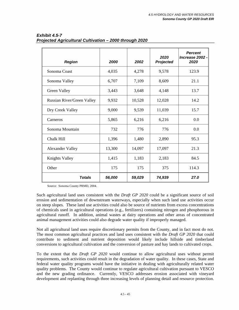
4.5 HYDROLOGY AND WATER RESOURCES Sonoma County GP 2020 Draft EIR
Exhibit 4.5-7 Projected Agricultural Cultivation – 2000 through 2020
Region 2000 2002 2020
Projected
Percent Increase 2002
2020
Sonoma Coast 4,035 4,278 9,578 123.9
Sonoma Valley 6,707 7,109 8,609 21.1
Green Valley 3,443 3,648 4,148 13.7
Russian River/Green Valley 9,932 10,528 12,028 14.2
Dry Creek Valley 9,000 9,539 11,039 15.7
Carneros 5,865 6,216 6,216 0.0
Sonoma Mountain 732 776 776 0.0
Chalk Hill 1,396 1,480 2,890 95.3
Alexander Valley 13,300 14,097 17,097 21.3
Knights Valley 1,415 1,183 2,183 84.5
Other 175 175 375 114.3
Totals 56,000 59,029 74,939 27.0
Source: Sonoma County PRMD, 2004.
Such agricultural land uses consistent with the Draft GP 2020 could be a significant source of soil erosion and sedimentation of downstream waterways, especially when such land use activities occur on steep slopes. These land use activities could also be source of nutrients from excess concentrations of chemicals used in agricultural operations (e.g., fertilizers) containing nitrogen and phosphorous in agricultural runoff. In addition, animal wastes at dairy operations and other areas of concentrated animal management activities could also degrade water quality if improperly managed.
Not all agricultural land uses require discretionary permits from the County, and in fact most do not. The most common agricultural practices and land uses consistent with the Draft GP 2020 that could contribute to sediment and nutrient deposition would likely include hillside and timberland conversions to agricultural cultivation and the conversion of pasture and hay lands to cultivated crops.
To the extent that the Draft GP 2020 would continue to allow agricultural uses without permit requirements, such activities could result in the degradation of water quality. In these cases, State and federal water quality programs would have the initiative in dealing with agriculturally related water quality problems. The County would continue to regulate agricultural cultivation pursuant to VESCO and the new grading ordinance. Currently, VESCO addresses erosion associated with vineyard development and replanting through three increasing levels of planning detail and resource protection.
4.5 - 45

4.5 HYDROLOGY AND WATER RESOURCES Sonoma County GP 2020 Draft EIR
These three levels of planning are dependent upon slope and the erodibility of site soils. Under VESCO, applicants for Level I type of vineyard development (i.e., occurring on less than ten percent slopes with highly erodible soils or on less than 15 percent slopes with less erodible soils) must identify sensitive areas; develop temporary and final erosion control and drainage management practices, and list implementation dates for temporary and final erosion and sediment control measures. Similar requirements are expected of applicants for Level II (i.e., occurring on ten to 15 percent slopes with highly erodible soils and on 15 to 30 percent slopes with less erodible soils) and Level III (i.e., occurring on 15 to 50 percent slopes with highly erodible soils or on 30 to 50 percent slopes with less erodible soils) vineyard development. For Level II and III slopes it is required that the erosion control plan be prepared by a civil engineer or other qualified professional. Provided the conditions of VESCO are met, permits for new vineyards and replants are (and would continue to be) non-discretionary. VESCO generally precludes vineyard development on slopes over 50 percent but does not currently address the planting of other crops, such as orchards or strawberries, on moderate to steep slopes.
From 1999 thru June 2004, 10,661 acres of Level I and 3,168 acres of Levels II and III replants and new vineyards were approved in the County. A summary of vineyard development approved under VESCO between June 1999 and June 2004 is presented in Exhibit 4.5-8.
Exhibit 4.5-8 Vineyard Development Approved Under VESCO June 1999 through June 2004
Level I Projects Acres
New 450 3,956
Replant 538 6,705
Total 988 10,661 Level II/III Projects Acres
New 140 2,949
Replant 18 219
Total 158 3,168 Total All 1,146 13,829
Source: Sonoma County Agricultural Division, Agricultural Commissioner, October 19, 2004. Available Online: www.sonoma-county.org/agcomm/vesco.htm
The Board of Supervisors recently directed that a new grading ordinance be prepared that would address erosion and sedimentation from all agricultural cultivation that could result in significant sedimentation.
To supplement existing regulations, the Draft GP 2020 contains policies designed to further reduce water quality degradation in the unincorporated area. Policy WR-1i and Water Resources Program 5: Grading Ordinance and Erosion and Sediment Control would adopt an erosion and sediment control ordinance for row crops similar to that which is currently required for vineyards under VESCO. Policy WR-1i would also allow for the development and implementation of agricultural educational and technical assistance programs and encourage on-site retention and recharge of runoff. Since chemicals that would be used in agricultural operations often bind to soil particles, on-site retention and / or detention could filter out sediment and other pollutants from site runoff, thereby protecting the water quality of downstream waters.
4.5 - 46
4.5 HYDROLOGY AND WATER RESOURCES Sonoma County GP 2020 Draft EIR
Policy OSRC-8c would afford some protection to stream corridors and stream stability as it would provide a set of principles and design standards for setbacks from stream zones, including those portions of stream corridors adjacent to row crops and vineyard planting.
Hydrologic changes, such as increased runoff from agricultural land conversions, could affect stream geomorphology and stream stability (e.g., accelerate stream bank and stream bed erosion or sediment accumulation), particularly if several large conversion projects would occur within the same watershed over a short period of time. Changes in peak runoff rates which modify the two-year channel-shaping flow, and changes in sediment supply (e.g., due to changes in land use activities) would further contribute to watershed instability. These hydrologic effects are often additive in watersheds that have a prior history of disturbance from rural development and intensive agricultural land uses, especially in watersheds that have a high percentage of agricultural cultivation or timberland conversion.
Cumulative hydrologic changes would be greatest when large portions of forested or brushland-dominated watersheds would be cultivated. Cumulative effects resulting from cultivation which could adversely affect the water quality in such streams include runoff, changes to stream geomorphology, and downstream stream instability.
As described in the regulatory setting, timber operations, including the harvesting and / or conversion of hardwoods to agricultural cultivation are primarily addressed at the state and regional level through the Timber Harvest Plan (THP) review program. This program is administered by the California Department of Forestry (CDF) in consultation with the RWQCB and the California Department of Fish and Game (CDFG). The County, interested members of the public, and State and federal agencies, are afforded the opportunity to comment on THPs during the review and approval process.
Although some California counties have supplemented the permit review process for THPs to address important local issues, this has not been the case in Sonoma County. In the late 1990s, Sonoma County submitted an application to the State Board of Forestry for local rules. However, this petition was rejected. The THP permit review process and the Forest Practices Rules may not adequately protect water quality, endangered species, and biological resources along streams. One concern is that the THP preparation and review process does not adequately assess cumulative hydrologic and water quality impacts in each watershed. Therefore, the existing timber harvest regulatory framework may not adequately prevent the degradation of water quality while at the same time limiting the County’s authority to do so. As a result, timber harvesting activities consistent with the Draft GP 2020 could degrade water quality unless properly managed through the State process.
The Draft GP 2020 contains policies intended to reduce water quality impact related to timber harvesting operations. Policies OSRC-12c and OSRC-12d would provide for county staff review and comment on THPs when related to the protection of Class III streams and riparian corridors. The Draft GP 2020 also includes policy OSRC-12e which would restrict timber conversions in Sonoma County, thereby reducing future vineyard cultivation on timberlands and potential erosion and sedimentation from this activity. Nonetheless, water quality impacts resulting from timber harvest operations are outside of County jurisdiction, and depending upon the effectiveness of State regulations, may not be fully mitigated.
In contrast, the existing regulatory framework for mineral resources extractions affords the County relatively greater authority over such activities. As previously described in the regulatory setting of Section 4.7 Geology / Soils, these activities are regulated in Sonoma County by the County’s Aggregate Resource Management Plan (ARM Plan) and at the state level by the Surface Mining and Reclamation Act. Most mining activities also require the preparation and review of a CEQA document as well as the evaluation of the adequacy of soil erosion and water quality control policies.
4.5 - 47
4.5 HYDROLOGY AND WATER RESOURCES Sonoma County GP 2020 Draft EIR
Sediment and erosion control plans are an important element of the CEQA review and mine permit process. Many State and federal resource and regulatory agencies participate in the review of such mine reclamation and erosion control plans, in addition to the review of county staff and watershed stakeholders. Therefore, project specific and cumulative adverse changes to water quality resulting from mining activities are generally considered to be adequately addressed through the ARM Plan and the CEQA review process.
Mitigation Measure 4.5-3 In order to further reduce water quality impacts resulting from erosion and hydrologic changes induced by agricultural production consistent with the Draft GP2020, additional policies or programs would be necessary. However, policies which would subject agricultural production to discretionary permit requirements may risk the economic viability of agriculture in Sonoma County. In light of the need to maintain the viability of agricultural production as expressed in the existing General Plan and in the Draft GP 2020, policies and programs which would focus on education and technical assistance in the development of BMPs for production activities would be more feasible.
Mitigation Measure 4.5-3(a) Revise Policy WR-li as follows to expand the scope of the educational and technical assistance programs to include BMPs for reducing erosion and sedimentation and runoff rates from cultivated slopes. Revise Policy WR-1i as follows:
Policy WR-1i: Implement erosion and sediment control requirements for vineyards and row crops. Develop and implement educational and technical assistance programs for agricultural activities including vineyard and crop production, development of BMPs which focus on reduction of peak runoff rates on all cultivated slopes, and erosion and sedimentation on slopes greater than 35 percent.
Mitigation Measure 4.5-3(b) Revise Water Resources Program 1: Education and Technical Assistance, as follows:
Program Description: Develop a public education and technical assistance program that provides property owners, applicants, and the general public with information regarding stormwater pollution, efficient water use, public water supplies, water conservation and re-use, and groundwater. Include the preparation of BMPs for agricultural cultivation that addresses reduction of peak runoff from cultivated slopes and erosion and sedimentation on slopes greater than 35 percent.
Significance After Mitigation While the recommended mitigation measures and other policies and programs of the Draft GP 2020 would reduce these impacts related to hydrology and water quality for many parts of unincorporated Sonoma County where resource land uses would occur to a less-than-significant level, this would remain a significant unavoidable impact. (SU)
Responsibility and Monitoring The Sonoma County Board of Supervisors would be responsible for adopting the revised policy and programs. PRMD and the Agricultural Commissioners Office would be responsible for their implementation.
4.5 - 48
4.5 HYDROLOGY AND WATER RESOURCES Sonoma County GP 2020 Draft EIR
Impact 4.5-4 Water Quality – Wastewater Disposal Land uses and development consistent with the Draft GP 2020 could result in sewer- and septic-related water quality problems including the reuse of treated water. However, policies provided in the Draft GP 2020 would adequately reduce such impacts to a less-than-significant level. (LTS)
Conventional wastewater treatment plants, package treatment plans, and failing septic systems could violate water quality standards and / or wastewater discharge requirements. Generally, the RWQCBs issue Waste Discharge Requirements (WDRs) permits for all major point-source discharges, such as municipal wastewater treatment plants and package wastewater treatment plants. All of Sonoma County’s treatment plants, including those operated by municipalities or wastewater management districts, are regulated under a WDR permit issued by the RWQCB. The County would be responsible for the water quality of wastewater discharge associated with the plants it operates. In cases where the plants are not directly operated by the County, the County’s role would be one of cooperation and coordination with the plants. Water quality problems associated with point source discharges from wastewater treatment plants have historically been infrequent, occurring mostly along the Russian River.
The regulation of privately-operated package wastewater treatment plants that occur in the county could be difficult due to the fact that the financial responsibility for plant operation, maintenance, and potential RWQCB penalties would be in the hands of private districts or property owners. Private owners may lack the financial resources to deal with water quality and maintenance problems when they arise.
Individual septic systems serving individual residences could also degrade water quality. This would be of particular concern in areas where historical development has resulted in a high concentration of older septic systems that are not regularly maintained or upgraded.
Water quality could also be affected by the reuse of treated wastewater from sewer plants for agriculture, landscaping, and other water demands. Depending on the extent of treatment that is applied to the wastewater, overapplication can result in excessive runoff that enters waterways.
The Draft GP 2020 Water Resources Element contains policies that address water quality issues associated with conventional and package treatment plants and septic systems. Policies WR-1k, WR1n, and WR-1o would specifically address failing septic systems. In areas with widespread septic system problems that cannot be addressed by on-site maintenance and management programs, Policy WR-1k would encourage the assessment as to feasibility of developing new treatment plants and / or the expansion of existing plants. The expansion and / or development of new community wastewater treatment plants would likely involve monetary contributions from all benefiting parties (i.e., local residents). The development of new or expanded facilities is often more cost-effective than the continual maintenance and replacement of failing septic systems.
Policy WR-1n would consider the formation of on-site wastewater management districts in areas with significant and widespread septic problems. The wastewater management districts would provide an area-wide framework for the proper design, inspection, repair, maintenance, and management of on-site sewage treatment systems.
Policy WR-1o would require that the County actively pursue the abatement of failing septic systems that have been demonstrated to cause a health and safety hazard. Implementation of this policy would require that the County establish violation thresholds, after which the property owner would be required to renovate or replace the septic system.
4.5 - 49

4.5 HYDROLOGY AND WATER RESOURCES Sonoma County GP 2020 Draft EIR
Policy WR-1l would initiate a review of any sewer systems that persistently fail to meet applicable standards. This policy would also apply to conventional wastewater treatment plants and package treatment plants. Where the sewer systems persistently fail to meet standards, the County may deny new development proposals and / or impose strict monitoring requirements. Policy WR-1l would affect new development proposals in areas where treatment facilities would have inadequate capacity, would be in need of maintenance, or would require a retrofit to meet new requirements.
Policy WR-1m specifically addresses commercial and industrial facilities. Implementation of this policy would encourage pretreatment and waste load minimization of commercial and industrial wastes prior to their connection to sewer systems. This policy would reduce the discharge of pollutants from commercial and industrial facilities that would not be easily or fully removed during wastewater treatment. This in turn would improve the quality of treated wastewater that would be discharged into county waterways.
Policies WR-4a through WR-4o include an array of measures that would encourage conservation and re-use of treated water. These policies would generally contribute to a reduction in the amount of wastewater discharged to waterways from wastewater treatment plants. Policy WR-4l in particular would provide that the quality of treated water be appropriate for beneficial uses. These policies would help reduce the potential for water quality impacts from wastewater systems.
Adoption and implementation of the relevant policies of the Draft GP 2020 would assure that impacts associated with failing sewer and septic systems would be reduced to a less-than-significant level. Sewer and septic systems are further discussed in Section 4.9 Public Services.
Mitigation Measure 4.5-4 None required.
GROUNDWATER
Impact 4.5-5 Groundwater Level Decline Land uses and development consistent with the Draft GP 2020 would increase demand on groundwater supplies and could therefore result in the decline of groundwater levels. This would be a significant impact. (S)
Existing and future land uses and development in unincorporated areas outside of the USAs have and would continue to be highly dependent on individual groundwater wells and small or independent water companies that rely on groundwater as their primary source of water supply. Ultimately, the sustainability of groundwater supplies would require that the volume of water cumulatively drawn from an aquifer not exceed the volume of groundwater recharge. If this water balance is not maintained over the long term, groundwater levels could eventually drop, resulting in the need to lower pumps, deepen wells, or drill new wells. Over time, groundwater supplies could be severely depleted and local aquifers may no longer be a dependable source of water. Class III and Class IV areas that could not maintain sustainable yields would likely be the first to experience groundwater shortages and dry wells. Eventually this problem could become widespread throughout major and secondary groundwater basins, especially during periods of prolonged drought.
As discussed in the setting section, anecdotal evidence indicates groundwater declines have already occurred in some areas of the county. In the past, groundwater levels have declined in some areas, but this trend has been reversed or partially reversed by reductions in pumping. One issue that makes the management of the County’s groundwater difficult is the current lack of a comprehensive inventory, assessment, and understanding of groundwater resources throughout the county. The availability and
4.5 - 50
4.5 HYDROLOGY AND WATER RESOURCES Sonoma County GP 2020 Draft EIR
quality of groundwater as well the effects of historical and present use are largely unknown. Therefore, the long-term viability and adequacy of groundwater supplies necessary to serve land uses and development consistent with the Draft GP 2020 is uncertain.
An assessment of groundwater resources in the major basins was last performed in the 1970s by the DWR and may not accurately represent existing conditions. SCWA and the US Geological Survey are conducting groundwater studies in the Alexander Valley and Sonoma Valley areas while the County has conducted studies in a number of smaller problem areas outside of these basins. Some of the cities such as Rohnert Park and Petaluma have also completed groundwater assessments for their portions of groundwater basins on which they rely.
The protection of major groundwater recharge areas is an important management tool for the protection of groundwater resources. Large areas of the county contain soils with high clay content that have poor infiltration and recharge characteristics or are underlain by hard bedrock formations that do not contain sizable groundwater bodies. In such areas, the majority of groundwater recharge occurs along streams. Significant portions of major recharge areas consist of permeable soils overlying important regional aquifers such as the Wilson Grove Formation. Major recharge areas are typically located along valley floors and are predominantly urban areas and / or areas where urban and suburban growth would occur, such as Sebastopol, Santa Rosa, and the northwest side of Petaluma. Volcanic rock formations, such as those that occur in the Sonoma Mountains, can also serve as important recharge areas. Urban development and the resultant increase in impervious cover over these recharge areas has historically reduced natural recharge opportunities. Implementation of the Draft GP 2020 would result in the construction of additional impervious surfaces. Therefore, the protection of the remaining recharge areas for these important aquifers will play an important role in assuring long-term sustainability in terms of both quality and quantity.
The Draft GP 2020 includes several policies and implementation programs that would improve groundwater management practices and protect groundwater resources. Policies WR-2a and WR-2b would be implemented as part of the Education and Technical Assistance Implementation Program. Implementation of Policy WR-2a would support research that would monitor local groundwater conditions, aquifer recharge, watersheds, and streams. Policy WR-2b would initiate an educational program to inform residents, agriculture, businesses and other groundwater users of BMPs in the areas of efficient water use, water conservation, and increasing groundwater recharge.
Policies WR-2c, WR-2d, and WR-2e involve revisions to the current regulations regarding well permits and procedures and would provide for improved data collection and monitoring of groundwater supply and quality. Specifically, Policy WR-2c would instill new requirements for all permits to drill, replace, deepen or repair wells. The new requirements would include a clear description of proposed and existing well locations, depths, yield, drilling logs, soil data, flow direction, and water levels of proposed and existing wells on the site. This information would then be made available to applicants, to the extent allowed by the law, under the groundwater database and monitoring program established by policies of the Draft GP 2020. Policy WR-2c would require that setbacks be developed based on well size, location of nearby wells, water use, groundwater availability, lot size, and other appropriate factors. In Class III and Class IV areas, this policy would also require proof that local groundwater quantity and quality would be sufficient for the proposed uses and existing beneficial uses. Policy WR-2c would also require monitoring for all future wells (i.e., through meters and testing) to report water levels, flow direction, and water quality. Where applicable, actions performed under this policy would be consistent with adopted groundwater management plans.
4.5 - 51
4.5 HYDROLOGY AND WATER RESOURCES Sonoma County GP 2020 Draft EIR
One of the purposes of Policy WR-2d would be to avoid overdraft conditions in Class III and Class IV areas throughout the county. Policy WR-2d addresses the groundwater impacts of discretionary projects and would be similar to Policy WR-2c in that it would require proof of groundwater with a sufficient yield and quality to support proposed uses in Class III and Class IV areas. This policy would require that test wells be established for community water systems in Class IV water areas and possibly in Class III areas where groundwater availability is not well understood.
Implementation of Policy WR-2e would revise the procedures for proving adequate groundwater for discretionary projects. The policy would add appropriate criteria regarding study boundaries, review procedures, and regional groundwater supplies and surface water flows.
Policy WR-2f addresses groundwater recharge and how it could be reduced by increases in impervious surfaces. This policy would require that discretionary projects maintain or increase the site’s pre-development absorption of runoff to recharge groundwater to the maximum extent practicable. This policy, which would presumably be implemented as a condition of approval during a project’s CEQA review phase, would provide a general protection of groundwater recharge areas. However, small development projects which do not require discretionary approval, such as individual residences, would not be subject to these conditions. Such development could adversely affect groundwater recharge in areas in which it would occur.
Groundwater monitoring and the collection of groundwater data would be an important component of the Draft GP 2020. The Groundwater Monitoring and Annual Report Implementation Program, which includes Polices WR-1s, WR-2g, WR-2h, WR-2i, WR-2j, and WR-2k, would result in the development of a groundwater database and monitoring program consisting of well permit data and groundwater basin studies. This program and the policies that comprise it would facilitate evaluation of current groundwater conditions. This program would also include the preparation of an annual report to the Board of Supervisors to assess the current status of groundwater conditions in unincorporated areas of the county.
Policy WR-2g would support the establishment and maintenance of a system of monitoring wells throughout the county by the County, SCWA, and other agencies. The system would utilize existing wells where feasible.
Policy WR-2h would establish a computerized groundwater database from available application data, well tests, monitoring results, study reports and other sources. This data would be provided to the DWR and would be used to refine the mapping of groundwater availability classes.
Policy WR-2i would identify areas where groundwater supplies may be declining through the review of well permit and monitoring data. This data would be used to report problems and make recommendations to the Board of Supervisors regarding areas that need further study in the annual report. For each special study area approved by the Board of Supervisors, a comprehensive groundwater assessment would be conducted that would include: the establishment of a system of monitoring wells and stream gages; identification of all water wells within the study area; the collection and presentation of available groundwater levels and contamination; the preparation of maps and graphics that show past and present data and changes in relevant variables such as precipitation, surface water imports, groundwater levels, groundwater quality, and rates of extraction; use of drillers logs and other geologic data to estimate water yields in an area; estimation of future rates of imports, recharge, extraction, changes in groundwater levels and possible changes in groundwater quality; determination of any needed changes in well monitoring, data collection, and reporting; and provisions for applicant fees and other funding to help cover costs of such an
4.5 - 52
4.5 HYDROLOGY AND WATER RESOURCES Sonoma County GP 2020 Draft EIR
assessment. Implementation of Policy WR-2i would be an important step in evaluating the condition of groundwater resources in order to develop better groundwater management practices in the county.
Policy WR-2j would assist in the development of a comprehensive groundwater assessment for each major groundwater basin in the county. While Policy WR-2i would focuses on specific study areas that may not coincide with groundwater basin boundaries, Policy WR-2j would aim towards basin-wide assessments for all major basins in the county. The assessments would be performed, as resources permit, through coordination with the incorporated cities, the SCWA, the DWR, the USGS, groundwater industry representatives, and other stakeholders in groundwater resources. The contents and process of each groundwater assessment would meet the requirements of the California Water Code for a “groundwater management plan” and may include, but are not limited to: computer modeling; water quality contaminant assessments; analysis of resource limitations and relationships to other users for wells serving public supply systems and other large users; opportunities for changing the sources of water used for various activities to better match available resources; possible funding sources for further research and management options; and provisions for applicant fees and other funding of County costs. Given that groundwater recharge would be largely dictated by rainfall and subsequent runoff, Policy WR-2k would encourage and support comprehensive studies of long-term regional changes in climate and precipitation patterns in the county.
Implementation of Policy WR-2l would increase the institutional capacity and expertise within the County to competently review hydrogeologic reports and data for critical indicators and criteria. This policy could involve hiring additional staff members to handle hydrogeologic issues within the County and / or create training programs for County officials to better educate them on hydrogeologic issues.
The policies and corresponding implementation programs found in the Draft GP 2020 would require additional funding for such projects to take place. Policy WR-2m would require the County to work with the SWRCB, the DWR, the DHS, the Cal EPA, and applicable County and City agencies to seek and secure funding sources for development of groundwater assessments, protection, enhancement, and management programs.
Policy PS-21 would consider regulations that would require the use of low impact development (LID) techniques oriented toward reduction of stormwater runoff. Secondary effects from such techniques would likely increase or protect groundwater recharge, thereby reducing the potential for groundwater decline.
Policies and programs contained in the Draft GP 2020 include provisions for assessing current groundwater conditions, the development of sustainable yield information and basin-wide monitoring programs, revisions to the well permitting process for improved data collection and monitoring, and provisions to encourage increased groundwater recharge. The Draft GP 2020 policies propose coordination between major water interests and water purveyors to prioritize groundwater basins for completion of the groundwater assessments and, at some time in the future, to develop a timeline for completion of the assessments, and where appropriate, to develop groundwater management plans. However, considering the uncertainty of the groundwater supply to sustainably meet the increased demand from land uses and development consistent with the Draft GP 2020, the policies and programs would take time to complete before establishing specific plans and appropriate management actions necessary to address groundwater problems that may arise.
Existing residences and near-term future land uses and development could be dependent on potentially declining groundwater resources. Once these resources have been adversely affected (i.e., groundwater levels lowered) recovery would be difficult.
4.5 - 53
4.5 HYDROLOGY AND WATER RESOURCES Sonoma County GP 2020 Draft EIR
In addition, as mentioned above, Policy WR-2f would require that discretionary projects maintain or increase the site’s pre-development absorption of runoff. However, non-discretionary projects, such as the rural residential development consistent with Exhibit 4.1-4, would not be required to compensate for potential decreases in groundwater recharge, including loss of recharge opportunities in important groundwater recharge areas.
Furthermore, the Draft GP 2020 would not directly address the long-term groundwater sustainability of non-discretionary projects in Class I and Class II areas that would rely on individual wells for water supplies. Projects that would be located in Class I and Class II areas would not be required to prepare project-specific hydrogeology reports nor provide proof of adequacy of water supply and long term sustainability unless the project would require discretionary review and approval. Projects involving high capacity agricultural wells would be of special concern in these areas.
Groundwater studies would only be required in such areas once the area has been formally identified by the Board of Supervisors as a groundwater problem area. On one hand, it would be difficult to recover groundwater resources in any given area once the problem has been identified and after new development has occurred that would add to the permanent groundwater usage demand. On the other hand, regulation of groundwater usage without well established evidence that justifies such regulation could be legally difficult in light of water related property rights.
Until county-wide groundwater assessments are prepared there simply is not enough current knowledge regarding groundwater availability and the sustainable yield of important aquifers. Preparation of these assessments could take several years to complete. Therefore, it cannot be determined conclusively that current and future groundwater supplies would be sufficient to serve land uses and development consistent with the Draft GP 2020. This would be a significant impact.
Mitigation Measure 4.5-5 Revise Policy WR-2f to include the following:
Policy WR-2f: Require that discretionary projects, to the maximum extent practicable, maintain or increase the site’s pre-development absorption of runoff to recharge groundwater. Implementation would include standards which could regulate impervious surfaces; vary by project type, land use, soils and area characteristics; and provide for water impoundments, protecting and planting vegetation, cisterns, and other measures to increase runoff retention and groundwater recharge. Develop voluntary guidelines for rural development that would accomplish the same purposes.
4.5 - 54
4.5 HYDROLOGY AND WATER RESOURCES Sonoma County GP 2020 Draft EIR
Significance After Mitigation Adoption of revised policy as outlined in Mitigation Measure 4.5-5, together with existing and proposed regulations, policies, and implementation programs, would serve to reduce potential adverse effects of future development consistent with the Draft GP 2020 on groundwater recharge. However, they would not do so to a less-than-significant level. Therefore, this would be a significant unavoidable impact. (SU)
Responsibility and Monitoring The Board of Supervisors would be responsible for adopting the policy proposed in Mitigation Measure 4.5-5 as part of the GP 2020. The PRMD would be responsible for adopting and implementing Policy WR-2f as outlined in Mitigation Measure 4.5-5.
Impact 4.5-6 Saltwater Intrusion Land uses and development consistent with the Draft GP 2020 would increase demand on groundwater supplies in areas susceptible to saltwater intrusion. Increased groundwater pumping in certain areas of the lower Petaluma River, Sonoma Creek, and Bodega Bay could result in saltwater intrusion. This would be a less-than-significant impact. (LTS)
Saltwater intrusion represents a potential threat to groundwater quality and is one of the current management issues facing groundwater resources in low-lying areas of the lower Petaluma River and Sonoma Creek basins near San Pablo Bay. The Bodega Bay community also has a salt water intrusion problem, and the Bodega Bay PUD is continuously battling saltwater intrusion in its wells that serve this unincorporated urban area. Saltwater intrusion occurs in areas where groundwater wells pump from aquifers that are hydraulically connected to saltwater (i.e., SF Bay and Pacific Ocean), inducing gradients that may cause the migration of saltwater towards the wells and potentially contaminate groundwater supplies.
Most of the south county areas that would be susceptible to saltwater intrusion are located in Class I groundwater areas. Because these low-lying areas are suitable for grape cultivation, vineyards have been increasingly planted in these areas over the last several years. These vineyards commonly depend on groundwater supplies for a portion of their irrigation needs. Currently, agricultural well permits, like other well permits, are non-discretionary and do not require the submittal of hydrogeologic studies or pump tests to the County as part of the well permit review approval, regardless of the groundwater availability classification of the area. There are also no existing regulations restricting the volume of water that such wells can pump, even if adjacent to domestic wells or in areas where saltwater intrusion is a management issue.
The development of new and expanded vineyards are discussed in Impact 4.5-3 Water Quality -Agricultural and Resource Uses and in Section 4.8 Agricultural and Timber Resources. In addition to continued vineyard planting in these areas, land uses and development consistent with the Draft GP 2020 would permit other agriculturally-related activities in these areas (e.g., dairies, wineries, etc), which may also utilize groundwater for their water supplies. Most of these facilities would require the issuance of some form of discretionary permit, such as a use permit, by the County, and therefore this issue would be subject to review during environmental review. However, specific analyses and testing requirements to address saltwater intrusion have not been developed as part of the well permit review process. Furthermore, there are no restrictions on water usage quantities in Class I and Class II areas.
The Land Use and Housing Elements of the Draft GP 2020 would also allow low density rural residential development in these areas. Larger development projects would be subject to issuance of discretionary permits, and thus CEQA review, which would provide a means for addressing the potential for saltwater intrusion and the application of appropriate use restrictions. However, smaller projects in conformance with the Land Use Plan and Zoning Code would likely not require discretionary review and approval. Since most areas subject to saltwater intrusion are located in
4.5 - 55
4.5 HYDROLOGY AND WATER RESOURCES Sonoma County GP 2020 Draft EIR
Class I groundwater areas, such projects would not be subject to the hydrogeologic review required of projects located in Class III and Class IV areas.
Saltwater intrusion is addressed directly and indirectly (i.e., inherent in overall groundwater quality) throughout Sections 3.1 and 3.2 of the Draft GP 2020 Water Resources Element. Policy WR-2g would support the establishment of a groundwater monitoring system throughout the county. The monitoring system would help to identify areas experiencing saltwater intrusion. In areas where monitoring or studies find that saltwater intrusion has occurred, implementation of Policy WR-1s would encourage analysis of the potential relationship between saltwater intrusion and groundwater extraction. The provisions of this policy could later be incorporated into groundwater management actions to avoid further intrusion. Policy WR-1t would be limited to the marshlands and agricultural areas south of Sonoma and Petaluma, where saltwater intrusion is already a problem. It would require environmental assessments and discretionary approvals to analyze and avoid any increase in saltwater intrusion into groundwater from additional extractions.
Policy WR-2i would assist in the identification of groundwater management problem areas, in terms of both water quantity and quality. The identification of such problems would be incorporated into the groundwater management plans that would be developed by Policy WR-2j. The problem with relying on this approach would be that the County would react to saltwater intrusion problems after the problems had developed or increased in severity. It can take several years from initial problem identification to development of appropriate groundwater management actions. Once saltwater intrusion problems develop, correcting, reversing, and remedying the situation can be extremely difficult and costly.
Non-discretionary land use and development entitlements could result in seawater intrusion associated with agricultural well development, low density development, and urban development. However, the relatively low density allowed in these rural areas, coupled with the fact that the Bodega Bay Public Utility District was able to develop wells in areas not affected by saltwater intrusion, would reduce this impact to a less-than-significant level.
Mitigation Measure 4.5-6 None Required.
Impact 4.5-7 Well Competition and Adverse Well Interference Land uses and development consistent with the Draft GP 2020 could result in an increase in the number of private wells in unincorporated areas of the county. Approval of wells in Class I or Class II areas could result in well interference impacts. This would be a significant impact. (S)
Groundwater wells in close proximity or adjacent to each other can be thought of as competing for the same groundwater resource, especially in areas where the availability of groundwater is limited, and / or in areas of poorly-producing aquifer materials. When a well is pumped, a portion of the aquifer around it is dewatered or lowered, creating what is known as a cone of depression. Adjacent wells with overlapping cones of depression may have problems getting water if water levels are lower than the well pumps. Where such competition is significant it may affect the performance and delivery of water to the adjacent well(s). This condition is referred to as well interference. Most well interference problems are localized and short in duration, but being without water is a major inconvenience and can cause damage to well pumps. In some instances, individual land owners are forced to deepen their wells or lower the pump to accommodate the localized lowering of groundwater levels due to well interference.
Potential adverse well interference effects can often be anticipated by a review of adjacent well logs and local hydrogeologic data. Where such interference is thought to be a potential concern, pump tests
4.5 - 56

4.5 HYDROLOGY AND WATER RESOURCES Sonoma County GP 2020 Draft EIR
can be conducted on tests wells located in the vicinity of the proposed well, in which water levels in the pumping well and near-by wells are monitored and mathematically analyzed using well hydraulic principles to verify and determine the probable extent and significance of the effect, and develop appropriate mitigation and management strategies.
The current Sonoma County groundwater well ordinance requires the completion of hydrogeologic studies only in water scarce areas (i.e., Class III and Class IV groundwater areas). Similar studies of potential well interference impacts may also be required associated with discretionary development projects. Generally, in Class I and Class II areas, the development of individual parcels, including small businesses, residences, and agriculture, if consistent with the General Plan and Zoning Code, do not require discretionary approval and would not be required to conduct pump tests or hydrogeologic studies. Policy WR-2c of the Draft GP 2020 calls for the revision of the current well ordinance to require that all new wells, both discretionary and non-discretionary, be located at defined distances from property lines and existing wells. The revised well ordinance provisions would apply to all groundwater areas, including Class I and Class II areas. Setbacks would vary by well size, location of nearby wells, water use, groundwater availability, lot size and other appropriate factors. However, pump tests to verify that there will not be adverse well interference effects may not be required in all cases, including large capacity wells in Class I and Class II zones.
The well setback requirements contained in Policy WR-2c of the Draft GP 2020 could eventually reduce the impacts associated with well interference. Establishing standardized criteria which will adequately address these impacts will be difficult to achieve due to the very diverse groundwater conditions in Sonoma County. If setbacks and testing standards are overly complex and costly, they may be difficult to accomplish for ministerial permits, particularly for agricultural production. However, until appropriate property setback requirements for new wells are developed and adopted, potential adverse well interference impacts could still occur for large capacity wells associated with nondiscretionary land uses. This would be a significant impact.
Mitigation Measure 4.5-7 Revise Policy WR-2c to require that pump tests be conducted for all new high capacity wells where there is reason to believe that there may be potential adverse effects on existing adjacent wells. Revise the end of Policy WR-2c to include the following:
Policy WR-2c: Revise ordinance requirements for permits to drill, replace, deepen or repair all wells as follows:
(Policy items 1-6 remain the same.)
(7) Require pump tests for new high capacity wells to avoid well interference.
Significance After Mitigation Adoption of revised Policy WR-2c as outlined in Mitigation Measure 4.5-7, together with existing regulations, policies, and implementation programs, would further reduce potential well interference impacts. However, due to the uncertainty of groundwater resources in many areas of the county and the time that it will take to adopt an ordinance, this would remain a significant unavoidable impact. (SU)
Responsibility and Monitoring The Board of Supervisors would be responsible for adopting the revised policy as part of the GP 2020. The PRMD would be responsible for implementing revisions to Policy WR-2c, including developing criteria to define high capacity wells and guidelines and requirements for completion of pump tests.
4.5 - 57
4.5 HYDROLOGY AND WATER RESOURCES Sonoma County GP 2020 Draft EIR
DRAINAGE
Impact 4.5-8 Changes to Drainage Patterns Leading to Streambank Erosion Land Use and development consistent with the Draft GP 2020 would result in alterations to existing drainage patterns. Such changes would increase erosion, both in overland flow paths and in drainage swales and creeks. This would be a significant impact. (S)
Alterations to drainage patterns and grading during construction activities have the potential to result in construction-related erosion problems. See Impact 4.5-2 Water Quality – Soil Erosion and Sedimentation Related to Construction for a discussion of construction-related erosion.
Land uses and development consistent with the Draft GP 2020 would result in a gradual increase in impervious cover, especially in urban service areas. Typically, increases in impervious cover result in an increase in stormwater runoff, higher peak stream discharges, and decreased groundwater recharge. Agricultural land uses practices commonly alter the infiltration properties of surface soils and can have similar effects on the hydrologic cycle. Increased peak discharges resulting from changes in land use have the potential to degrade water quality by creating erosive velocities and shear stress and ultimately cause erosion and sedimentation in drainage swales and streams. Minor increases in tributary flows can also exacerbate creek bank erosion and / or cause destabilizing channel incision. The magnitude of these effects depends on total impervious surfaces in the project watershed, the nature of the storm drain system, and the extent that the drainage system incorporates peak flow reduction methodologies (e.g., porous pavement, on-site stormwater detention, in-pipe detention).
Sonoma County has not adopted a policy of “no net increase in runoff” for new development on a county-wide basis. However, with the exception of the Santa Rosa Plain and the Petaluma and Sonoma Valleys, the watersheds in the county are not extensively urbanized or developed.
Currently, hydrologic and hydraulic analysis and design procedures, criteria, and standards for drainage and flood control projects in the county are summarized in the Sonoma County Water Agency Flood Control Design Criteria Manual. The manual was last revised in 1983. However, while the manual includes design criteria primarily for flood water conveyance capacity, it also includes general provisions for streambank erosion control which allow the County to require the latest BMPs.
In addition to current NDPES and SUSMP requirements discussed in the environmental setting and under Water Quality – Soil Erosion and Sedimentation Related to Construction, the Public Safety and Water Resource Elements of the Draft GP 2020 contain several stormwater management policies which would help mitigate the potential drainage and erosion impacts associated with new development. In general, the policies would encourage better land use planning through the use of appropriate hydrologic and hydraulic analysis in the discretionary project approval process with respect to site design, building location and drainage infrastructure design.
Soil erosion is also discussed in Section 4.7 Geology / Soils. Public Safety Program 2: Drainage, Erosion, and Fire Safety Standards for Subdivisions would require amendments to Chapter 25 of the Sonoma County Code to clarify standards for drainage, erosion control and fire safety. It is assumed that the amendments to the County Code would incorporate new erosion control standards and BMPs. Policies WR-1b and WR-1g would work to minimize sediment and other pollutants in stormwater runoff from County and private buildings and facilities through implementation of design criteria and water quality BMPs for ongoing maintenance and operation.
Public Safety Policy PS-2c would encourage cooperation between the County and the City of Petaluma in order to implement the Petaluma River Floodplain Management Plan, the Petaluma River
4.5 - 58
4.5 HYDROLOGY AND WATER RESOURCES Sonoma County GP 2020 Draft EIR
Access and Enhancement Plan, and City’s (pending) Surface Water Master Plan. These plans would improve storm water management through natural creeks, modified channels, and storm drains which flow to the Petaluma River. Such plans would assist in meeting federal regulations, upgrading and improving drainage infrastructure, and protecting the Petaluma River. The benefits of these plans would not be limited to areas within the Petaluma City limits. Coordination with the City of Petaluma would work to maximize the benefits of the plans to include unincorporated areas within the Petaluma River watershed.
Policy PS-2j would regulate development, water diversion, vegetation removal, grading and fills to minimize any increase in flooding and related damage to people and property. This policy would apply to many types of projects (besides building development) which can occur within stream corridors and could potentially adversely affect stream biological resources, water quality, and channel stability.
Policy PS-2l would encourage the County to develop regulations that require the use of Low Impact Development (LID) technologies. LID is a stormwater management approach that strives to manage rainfall runoff at the source using planning and site design techniques that include infiltration, filtration, storm water storage, evaporation, and detention. While traditional stormwater management systems are designed to function well under a single design condition (e.g., 10 year storm), LID uses the stormwater from more frequent events as a resource in efforts to restore the developed area’s natural rainfall-runoff and groundwater recharge relationships.
Policy OSRC-8b and OSRC-8c would also provide additional policy mitigation to protect stream corridors. In addition these policies would help protect stream water quality and stream stability by establishing streamside buffers and by limiting certain kinds of activities along streams that may be harmful to the functions and values of the streams.
In summary, current practices utilized in the review of flood control, drainage, grading permits, and stormwater runoff controls under the Phase I and II NPDES programs, as well as policies contained in the Draft GP 2020, would help to mitigate potential impacts associated with increased runoff and other surface drainage modifications, including potential impacts to channel stability, and stream bank erosion due to changes in drainage patterns. However, specific channel stability analysis techniques and channel and streambank erosion control design criteria are not currently included in the County Code or in the Flood Control Design Criteria Manual.
Updating this design manual and the County Code to more specifically address these factors would reduce these impacts for new urban development and for larger projects in rural areas to a less-than-significant level. In addition, development of a new grading, erosion control, sedimentation, and drainage ordinance, currently in process, would reduce these impacts for some agricultural cultivation and other rural uses. However, land use activities in rural areas that are not subject to these requirements may result in drainage alterations that could lead to erosion. Therefore, this would be a significant impact.
Mitigation Measure 4.5-8 Add a new policy to Section 3.1 of the Water Resource Element addressing the effects of changes in drainage patterns leading to increased erosion in drainage swales and streams. Add a new policy WR-1w as follows:
Policy WR-1w: Revise the County’s flood control design criteria to include a section on stream geomorphic analysis and to update information on bank protection and erosion control to incorporate biotechnical bank stabilization methods for the purpose of preventing erosion and siltation in drainage swales and streams.
4.5 - 59
4.5 HYDROLOGY AND WATER RESOURCES Sonoma County GP 2020 Draft EIR
Significance After Mitigation While adoption of Policy WR-1w as outlined in Mitigation Measure 4.5-8, together with existing regulations, policies, and implementation programs, would reduce the potential impacts related to downstream erosion and siltation resulting from alterations in drainage patterns, such impacts would not be reduced to a less-than-significant level in all cases. Therefore, this would remain a significant unavoidable impact. (SU)
Responsibility and Monitoring The Board of Supervisors would be responsible for adopting the revised policy proposed in Mitigation Measure 4.5-8 as part of the GP 2020. The PRMD would be responsible for implementation of Policy WR-1w and developing the flood control design criteria.
Impact 4.5-9 Increased Flood Risk from Drainage System Alteration Land uses and development consistent with the Draft GP 2020 would result in increases in stormwater runoff and peak discharge. Existing storm drain systems, including urban creeks and rivers, may be incapable of accommodating increased flows, potentially resulting in on- or off-site flooding. However, policies and programs contained in the Draft GP 2020 would reduce such impacts to a less-than-significant level. (LTS)
Land uses and development consistent with the Draft GP 2020 could increase runoff and modifications to local and regional hydrology. While the majority of future development would be concentrated in the cities, future development in presently undeveloped areas of the county may necessitate the construction of new drainage facilities for stormwater conveyance and management. In areas where drainage infrastructure already exists, drainage systems may need to be enlarged or expanded to accommodate future growth. Stormwater management practices commonly used to mitigate increases in peak flows (e.g., detention, retention, infiltration) may also be implemented throughout the county, as deemed appropriate under policies in the Draft GP 2020.
Local storm drainage modifications, stream channel alterations, and structural bank stabilization measures could create significant flooding impacts, in some cases by moving the existing flooding and channel instability problems cross channel or downstream, or by changing the timing of peak flows and point of discharge of runoff.
The SCWA Flood Control Design Criteria manual is generally used as the technical reference for procedures and design criteria for completing the hydrologic / hydraulic and drainage studies and in developing drainage improvement recommendations. PRMD’s drainage review practices also address drainage and flooding issues as part of both discretionary and ministerial projects
Several policies and implementation programs contained in the Draft GP 2020 would address potential drainage and flooding issues associated with future development and land uses. Implementation of Public Safety Program 2: Drainage, Erosion, and Fire Safety Standards for Subdivisions would include amendments to Chapter 25 of the Sonoma County Code to clarify drainage standards.
Policy PS-2a would make information related to surface drainage, flooding and flood hazards available to the appropriate County departments (e.g., Public Works and PRMD). Historical flood data and flood hazard delineation maps facilitate the identification of known flood hazards, their geographic extent, and frequency of flood occurrence. This information would be utilized during the planning and development review process, particularly for development sites located in or adjacent to a flood plain, but also for sites located upstream or downstream of known flood hazard areas. This would ensure any development would not exacerbate existing flooding problems. This policy is part of the Public Safety Program 1: Safety Hazards Information System proposed under the Draft GP 2020 and would be a useful resource during the development of project drainage plans.
4.5 - 60
4.5 HYDROLOGY AND WATER RESOURCES Sonoma County GP 2020 Draft EIR
Policy PS-2b would allow for continued coordination among the US ACOE, the FEMA, the SCWA, and other responsible State and local agencies associated with flood hazard analysis and surface water management. Coordination among responsible agencies would facilitate better identification of appropriate drainage and flood management requirements for new development and necessary flood control improvement projects. This policy would also be part of the Safety Hazards Information System proposed under the Draft GP 2020.
Policy PS-2c would encourage cooperation between the County and the City of Petaluma in the implementation of the Petaluma River Floodplain Management Plan, the Petaluma River Access and Enhancement Plan, and City’s (pending) Surface Water Master Plan. These plans would improve stormwater management through natural creeks, modified channels, and storm drains which flow to the Petaluma River. Such plans would assist in meeting federal regulations, upgrading and improving drainage infrastructure, and protecting the Petaluma River. The benefits of these plans would not be limited to areas within the Petaluma City limits. Coordination with the City of Petaluma would work to maximize the benefits of the plans to include unincorporated areas within the Petaluma River watershed.
Policy PS-2d would require the County to further develop and continue to implement a program for the “Reduction of Russian River Flood Damage”. This policy would have several components including: flood data collection by geographic location; acquisition of properties in flood prone areas; an ongoing building elevation program; a flood mitigation plan to allow County participation in FEMA assistance programs and grant funds; the use of redevelopment funds to supplement FEMA grant funds in reducing repetitive flood losses; and consideration of permit fee reduction for elevation of structures in flood hazard areas and outreach to inform property owners in flood hazard areas about various options for coverage under the NFIP.
Policy PS-2e would expand the County’s Zero Net Fill Ordinance that is currently only applicable to the Laguna de Santa Rosa to encompass all of the unincorporated areas subject to flooding. The no net fill policy refers to any material brought on to a project site within a flood plain area that would displace floodwaters and result in flooding elsewhere. The policy would require that all fill be offset by the removal of a like amount of material in order to result in a reasonable equivalence of hydrology and hydraulics between pre- and post-development. For purposes of compliance, one or more individual parcels or an entire reach may demonstrate a zero net fill balance. Implementation of this policy would help prevent new development from causing or exacerbating flood problems on adjacent properties.
Policy PS-2f would continue the current policy of enabling decision-making associated with land use planning and development through the review of FEMA maps or parcel-specific scaled interpretations of these maps and site-specific elevation data. This review would help determine appropriate stormwater and flood control requirements based on specific site conditions.
Policy PS-2g would require that the County prepare a comprehensive analysis of the potential flood hazards and drainage impacts and associated needs for adopted land use plans for each major watershed located in the county. This would facilitate identification and mitigation of direct and cumulative flood impacts resulting from the loss of permeable surfaces. New development would be required to contribute to the drainage and flood control studies. New development and redevelopment would also be required to fund mitigations for the control of downstream flooding impacts caused by upstream development. Pending completion of these drainage studies, individual project applications would be required to analyze and mitigate drainage impacts, based upon land use plans. In the event that the PRMD determines the project could have a cumulative significant impact on downstream flooding, the project applicant would be required to either prepare a supplemental EIR on such an
4.5 - 61
4.5 HYDROLOGY AND WATER RESOURCES Sonoma County GP 2020 Draft EIR
effect, modify the project to include drainage improvements, or participate in a funding mechanism for construction of appropriate downstream flood control improvements. Policy PS-2g would represent a significant change in County storm water management and flood control policy. Implementation of the policy would apply more rigorous drainage requirements to new development projects. It would also play a role in addressing the drainage impacts resulting from development in the cities, where the bulk of urban runoff occurs but is outside the County’s jurisdiction.
Policy PS-2h would continue to set the 100-year flood event and corresponding flood elevations as the threshold by which the County would measure acceptable risk and protection in the consideration of any amendments of the land use map.
Policy PS-2i would require review of potential on-site and off-site flood related hazards for all substantial development and redevelopment projects requiring discretionary approval located within areas subject to known flood hazards. This would include identification of flooding impacts to the proposed project as well as flooding-related impacts to surrounding areas that could result from project development.
Policy PS-2j would regulate development, water diversion, vegetation removal, grading and fills to minimize any increase in flooding and related damage to people and property. This policy would apply to many types of non-development projects that occur within stream corridors.
Policy PS-2k would limit the placement of fill in floodplains and other areas that could retain or detain a significant amount of runoff and floodwater. This policy does not necessarily refer only to areas within existing flood hazard zones or floodplains, but could be applied to natural detention areas as well as areas adjacent to a floodplain where it may be suitable to construct a detention facility.
Policy PS-2l would encourage the County to develop regulations that require the use of Low Impact Development (LID) technologies. LID is a stormwater management approach that strives to manage rainfall runoff at the source using planning and site design techniques that include infiltration, filtration, storm water storage, evaporation, and detention. While traditional stormwater management systems are designed to function well under a single design condition (e.g., 10 year storm), LID uses the stormwater from more frequent events as a resource in efforts to restore the built area’s natural rainfall-runoff and groundwater recharge relationships.
Implementation of Policy PS-2m would require that the payment of costs for drainage facilities to handle surface runoff from new development be the responsibility of developers and others who benefit from the facilities. Policy PS-2m would require that new development, and those who benefit from construction of the drainage facilities, fund (or participate in a funding mechanisms) for new drainage infrastructure improvements.
Policy PS-2n would require that the design and construction of drainage facilities be subject to the review and approval of the PRMD. The PRMD would ensure the proposed drainage facilities comply with all applicable drainage and flood control standards prior to project approval.
Policy PS-2o would require that tentative and final subdivision maps and approved site plans show areas subject to flooding as shown on FEMA maps. This policy would involve overlaying digital FEMA flood hazard maps on top of tentative maps to facilitate project planning and design review.
Policy PS-2p would emphasize floodplain management over flood control structures for preventing damage from flooding except where the intensity of development requires a high level of protection and justifies the cost of structural measures. Examples of floodplain management measures include
4.5 - 62
4.5 HYDROLOGY AND WATER RESOURCES Sonoma County GP 2020 Draft EIR
the no net fill ordinance, restricting the placement of structures in regulatory floodways, and raising building elevations above the 100-year floodplain.
Policy PS-2q would consider the potential risk of damage from flooding in the design and review of projects, including those which could facilitate floodplain development.
Under Policy PS-2r, the County would be required to avoid variances to building setbacks along streams and in 100-year floodplains without the review and approval of PRMD.
Implementation of Policy PS-2s would require that the SCWA be responsible for prioritizing and undertaking flood hazard mitigation projects on a continuous basis on selected waterways subject to the policies of the Open Space and Resource Conservation Element.
Policy PS-2u would encourage completion and filing of inundation maps for all dams whose failure could cause loss of life or personal injury within Sonoma County. Inundation maps would help planners in assessing the potential impacts of dam failure.
Policies in the Open Space and Resource Conservation Element would restrict development in riparian corridors along all intermittent and perennial streams thereby slowing stormwater runoff flowing into streams. In addition, policies in the Water Resources Element which provide for stormwater pollution controls for urban development and for large projects in rural areas may also reduce the rate of surface water runoff and potential downstream drainage and flooding problems.
Adoption and implementation of the policies and programs contained in the Draft GP 2020 and discussed above would ensure that potential impacts of future development of on- and off-site flooding and drainage infrastructure would be reduced to a less-than-significant level. Although flooding would continue to occur in flood prone areas, this is considered an existing condition for purposes of CEQA review, and the policies and programs of the Draft GP 2020 would ensure that flooding in these areas would not worsen. It should also be noted that the cities are expected to e the primary contributors to large-scale drainage alterations that could lead to flood risk, particularly the cities in the central county area.
Mitigation Measure 4.5-9 None required.
FLOODING
Impact 4.5-10 Place Housing or Structures in 100-Year Flood Hazard Areas Land uses and development consistent with the Draft GP 2020 would allow continued development in 100-Year Flood Hazard Areas. However, policies and programs contained in the Draft GP 2020 would reduce such impacts to a less-than-significant level. (LTS)
The Draft GP 2020 Land Use and Housing Elements generally would continue to allow new development and redevelopment within unincorporated areas designated as FEMA 100-year flood hazard areas. However, the Draft GP 2020 would provide policies to mitigate the potential consequences of such development by means of appropriate design criteria to protect both proposed structures as well as existing structures downstream.
Potential flooding impacts in Sonoma County due to development would not be limited to the unincorporated urban service areas. When severe flooding occurs, it affects flood areas throughout the
4.5 - 63
4.5 HYDROLOGY AND WATER RESOURCES Sonoma County GP 2020 Draft EIR
major basins. Flood zone hazards are therefore subregional in geographic scope, and could affect county residents, structures, and land use activities throughout large portions of the county.
Several FEMA-designated floodplain areas within Sonoma County have a history of repetitive flood damage. These include areas along Sonoma Creek in and near the city of Sonoma, along the Petaluma River above and within the City of Petaluma, along the Laguna de Santa Rosa in and near Sebastopol, and along the middle and lower course of the Russian River, including the communities of Guerneville and Monte Rio.
Section 7B of the current County Code requires that residential structures built within FEMA-designated 100-year flood hazard zones be elevated at least one foot above the elevation of the 100year flood level to protect these structures from flood damage. New nonresidential buildings must either meet this criterion or provide an alternate method of flood proofing that is certified by a registered engineer and approved by the PRMD Chief Building Inspector.
The Draft GP 2020 contains several policies and implementation programs to mitigate potential impacts arising from development in 100-year flood hazard zones. Many of these policies are discussed above under Impact 4.5-9 Increased Flood Risk from Drainage System Alteration and apply to general flood issues as well as issues associated with development in 100-year flood hazard areas. The policies described below are specific to development within 100-year flood hazard zones.
Revisions to the County’s Zero Net Fill Ordinance as required under Policy PS-2e would extend the requirements of the ordinance to apply to all unincorporated areas of the county subject to flooding. This policy would require that any material placed within the 100-year floodplain that would displace floodwaters and result in flooding elsewhere be offset by the removal of a like amount of material. This policy would result in a reasonable equivalence of hydrology and hydraulics between pre- and post-development conditions. For instance, because residential structures in the floodplain must be elevated at least one foot above base flood elevations, the amount of fill placed to elevate the structure must be balanced by soil removal in an adjacent portion of the floodplain to prevent the downstream displacement of floodwaters.
Policy PS-2g would require that the County prepare a comprehensive analysis of potential flood hazards and drainage impacts and associated needs for adopted land use plans for each major watershed located in the county. This would include the comparison of FEMA flood hazard zones with designated land uses and facilitate identification and mitigation of potential flood impacts.
Policy PS-2h would continue to set the 100-year flood event and corresponding flood elevations as the threshold by which the GP 2020 would measure acceptable risk and protection in the consideration of any amendments to the Land Use map.
Policy PS-2o would require that tentative and final subdivision maps and approved site plans show areas subject to flooding as shown on FEMA maps. This would allow County planners to better evaluate the potential for flood impacts as a result of project approval. For all projects located within areas subject to known flood hazards, Policy PS-2i would require a technical review of on-site and off-site flood related hazards. Under Policy PS-2h, the 100-year flood event and corresponding flood elevations would be the threshold by which the County would measure acceptable risk and protection in the consideration amendments to the land use map. As required under Policy PS-2r, the County would be required to avoid issuing variances to building setback requirements along streams and in 100 year floodplains without detailed hydrologic/hydraulic review and approval of PRMD.
4.5 - 64
4.5 HYDROLOGY AND WATER RESOURCES Sonoma County GP 2020 Draft EIR
Development consistent with the Draft GP 2020 within designated 100-year flood hazard zones in unincorporated areas would be subject to development standards aimed at minimizing onsite and offsite flood damage. Implementation of the above policies and their corresponding implementation programs would reduce potential impacts associated with development in the 100-year flood hazard area to a less-than-significant level.
Mitigation Measure 4.5-10 None required.
Impact 4.5-11 Impede or Redirect Flows in Flood Hazard Areas The placement of land uses and development, particularly structures within 100-year flood hazard areas could impede or redirect flood flows, resulting in secondary flood damage including bank instability and erosion. This would be a significant impact. (S)
The Draft GP 2020 Land Use and Housing Elements would continue to allow new development and redevelopment within unincorporated areas designated as FEMA 100-year flood hazard areas. Policies and programs included in the Draft GP 2020 would seek to mitigate the potential consequences of such development on both proposed structures as well as existing structures located downstream. The Draft GP 2020 would focus on the assessment and prevention of the 100-year flood damage, especially from building in flood hazard zones and in areas of repetitive flooding. This issue is particularly important along the lower Russian River where communities such as Guerneville were established many years ago in flood hazard areas. Neither removal of these communities entirely outside of flood zones nor avoidance of all construction on these urban lots is feasible.
Drainage and flood hazard reduction policies were discussed under Impact 4.5-9 Increased Flood Risk from Drainage System Alterations. Especially relevant to the discussion of flow impedance and redirection is Policy PS-2e. Implementation of this “No Net Fill” policy, along with standard FEMA policies and current County zoning regulations in flood zones, would prevent most occurrences of flood flow impedance and flow redirection.
However, flood damage can also be defined more broadly to include bank failure and streambed and bank erosion during high flow events. Therefore, the geomorphic consequences of building in 100year flood hazard areas associated with the obstruction or redirection of flood flows and increased downstream channel instability from increased flows and increased flood flow velocities also need to be considered.
The development of currently vacant land areas within floodplains, especially in rural areas that have not previously had drainage improvements made, typically involves the modification of minor surface waterways and tributary stream courses. Where development occurs within the floodplain of a larger stream course, most often some form of channel modification is required, either locally to accommodate new storm drainage outfalls, or as is sometimes the case, local stream re-alignment and structural bank stabilization. The practice of lining channel banks with rock riprap and other hard structures can cause cross bank and downstream channel instability problems. In some cases where the toe or face of the structures encroach into the stream channel, this can also redirect flow, constrict channels (causing backwater flooding effects), or increase local turbulence and flow velocities (causing bank erosion).
Local storm drainage modifications, stream channel alterations, and structural bank stabilization measures can create significant flooding impacts. In some cases these include redirecting or moving existing flooding and channel instability problems cross channel or downstream, or by changing the timing of peak flows and the point of discharge of runoff.
4.5 - 65
4.5 HYDROLOGY AND WATER RESOURCES Sonoma County GP 2020 Draft EIR
The Draft GP 2020 contains several policies that would reduce the potential for the placement of inappropriate land uses and development in flood hazard areas. These policies are listed in the discussion of Impact 4.5-9 Increased Flood Risk from Drainage System Alterations.
In addition to these policies, the current standards of the County Zoning Code prohibit the placement of permanent structures in the floodways with some exception for properly designed and placed bank stabilization projects. Structures placed in the floodplain are allowed, but only outside the floodway such that they would not be expected to substantially impede or redirect flood flows substantially.
However, these regulations and policies would not avoid alteration of the channel environment nor would they avoid new construction in flood hazard areas such as the lower Russian River. Therefore, this would be a significant impact.
Mitigation Measure Same as Mitigation Measure 4.5-8.
Significance After Mitigation Revision of Policy WR-1w as identified in Mitigation Measure 4.5-8, together with existing regulations, policies, and implementation programs, would reduce the impacts associated with flow impedance and redirection of flood flows. However, this would remain a significant unavoidable impact. (SU)
Responsibility and Monitoring The Board of Supervisors would be responsible for adopting the revised policy proposed in Mitigation Measure 4.5-8 as part of the GP 2020. The PRMD would be responsible for implementation of Policy WR-1w and developing flood control design criteria.
Impact 4.5-12 Failure of Levee or Dam Potential failure of levees or dams could expose people and structures to inundation and result in loss of property, increased risk, injury or death. This would be a significant impact. (S)
The County has 44 regulated dams within its boundaries. Larger dams whose potential failure could cause severe inundation include the Warm Springs Dam built by the Army Corps of Engineers in 1983 at the confluence of Warm Springs Creek and Dry Creek, and the Coyote Dam built in 1958 on the East Fork Russian River in Mendocino County. Although the County has not experienced dam failure in the last 20 years, the sudden failure of any one of these facilities, for instance, in response to a large magnitude earthquake, could potentially cause flooding in communities downstream of the dams. 10
Specific requirements with respect to most non-federal dam designs and operations are established by the California Division of Safety of Dams, which are administered by the County. The US Army Corps of Engineers is responsible for the operation of the Warm Springs facility, including completing requisite safety inspections. The California Government Code requires periodic safety inspections of dams, completion of studies that predict the flood zones created by sudden dam failure, and the development of emergency response plans in the advent of pending dam failure, including a program for emergency warning and evacuation prepared by the Emergency Management division of the Sonoma County Department of Emergency Services. The contingency plans are updated every two years and submitted to the State Office of Emergency Services for review and comment. Incorporated cities are responsible for developing contingency plans for State-designated dams affecting
10 Sonoma County Department of Emergency Services, 2004.
4.5 - 66
4.5 HYDROLOGY AND WATER RESOURCES Sonoma County GP 2020 Draft EIR
incorporated areas. Sonoma County has the responsibility for developing emergency plans for State-designated dams affecting unincorporated areas.
Unlike some areas of California, Sonoma County does not have an extensive system of levees that provide urban flood protection that are susceptible to catastrophic levee failure. Levees and floodwalls that are constructed as part of U.S. Army Corps of Engineers or Department of Agriculture flood control projects, or by local city or Flood Control District programs administered jointly by the County Water Agency also are required to undergo periodic inspections for safety and performance as part of routine maintenance plans. Such plans are completed as elements of project design and operational planning. However, it is recognized that the levees along the Russian River below Coyote Dam are the responsibility of the Corps of Engineers. Levee and floodwall assessment is also typically completed as part of a FEMA Flood Insurance Rate study, including floodplain mapping updates.
The most extensive series of levees in Sonoma County that are potentially susceptible to failure are the predominantly non-engineered farm levees that protect low lying farmland and rural housing along the lower reaches of the Petaluma River and Sonoma Creek. Although some of these may be maintained by small reclamation districts, most of the non-engineered farm levees in these areas are maintained by the individual farmers and ranchers. Technical support and assistance are sometimes provided by the Department of Agriculture and local Resource Conservation Districts. Levees in these areas probably represent the greatest risk of levee failure, and several farm levees along the lower Petaluma River and Sonoma Creek failed during flood events as recently as 1998. Although several low lying farmhouses and some farm buildings and equestrian facilities were flooded, and there was some loss of agricultural crops, widespread damage did not occur.
New dams and levees, however, would be subject to review and approval of the State Division of Dam Safety, the State Division of Water Rights, and County grading permit requirements that would reduce the future likelihood of dam failure. Where a flood control district had jurisdiction, dams and levees would be reviewed and approved by the district.
Policy PS-2u of the Draft GP 2020 would encourage timely completion and filing of inundation maps for all dams whose failure could cause loss of life or personal injury within Sonoma County. Such maps would assist planners in determining potential inundation hazards for existing and future development.
The failure and inundation potential of all dams and levees within unincorporated portions of the county is not presently known. Implementation of Policy PS-2u would identify dam and levee failure inundation areas and allow for potential improvements in emergency planning. However, the Draft GP 2020 does not include provisions to investigate the stability of existing non-engineered farm levees and small farm dams that may require rehabilitation to protect adjacent or downstream development from inundation. This would be a significant impact.
Mitigation Measure 4.5-12 Revise Policy PS-2u to include a provision for review and rehabilitation of dams and levees that pose a significant threat of inundation to adjacent or downstream development. Revise the end of Policy PS-2u to include the following text:
Policy PS-2u: Encourage the timely completion and filing of inundation maps for all dams whose failure could cause loss of life or personal injury within Sonoma County. Where inundation maps indicate dam or levee failure could cause loss of life or property or personal injury, coordinate with the corresponding responsible party to investigate levee or dam stability and management and identify rehabilitation and maintenance needs as appropriate.
4.5 - 67
4.5 HYDROLOGY AND WATER RESOURCES Sonoma County GP 2020 Draft EIR
Significance After Mitigation Adoption of the revised Policy PS-2u as outlined in Mitigation Measures 4.5-12, together with other existing flood prevention strategies and policies, would reduce potential inundation hazards to existing and future development to a less-than-significant level. (LTS)
Responsibility and Monitoring The Board of Supervisors would be responsible for adopting the revised policy proposed in Mitigation Measure 4.5-12 as part of the GP 2020. The PRMD would be responsible for implementation of Policy PS-2u.
4.5 - 68