Embed Size (px)
Citation preview
4. Environmental Setting (Affected Environment), Impacts, and Mitigation Measures 4.8 Land Use, Land Use Planning, and Recreation
CalAm Monterey Peninsula Water Supply Project 4.8-1 ESA / 205335.01 Draft EIR/EIS January 2017
4.8 Land Use, Land Use Planning, and Recreation Sections Figures Tables
4.8.1 Setting/Affected Environment
4.8.2 Regulatory Framework
4.8.3 Approach to Analysis
4.8.4 Evaluation Criteria
4.8.5 Direct and Indirect Effects of the Proposed Project
4.8.6 Cumulative Effects of the Proposed Project
4.8-1 Coastal Zone
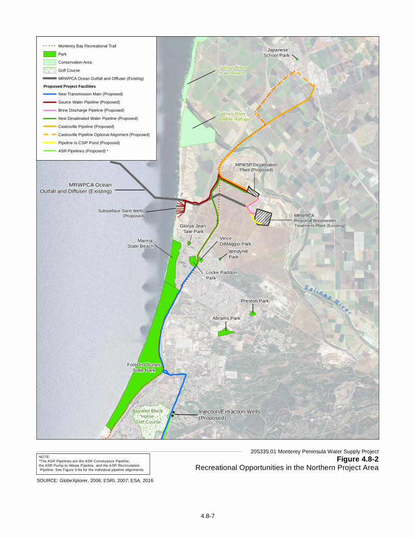
4.8-2 Recreational Opportunities in the Northern Project Area
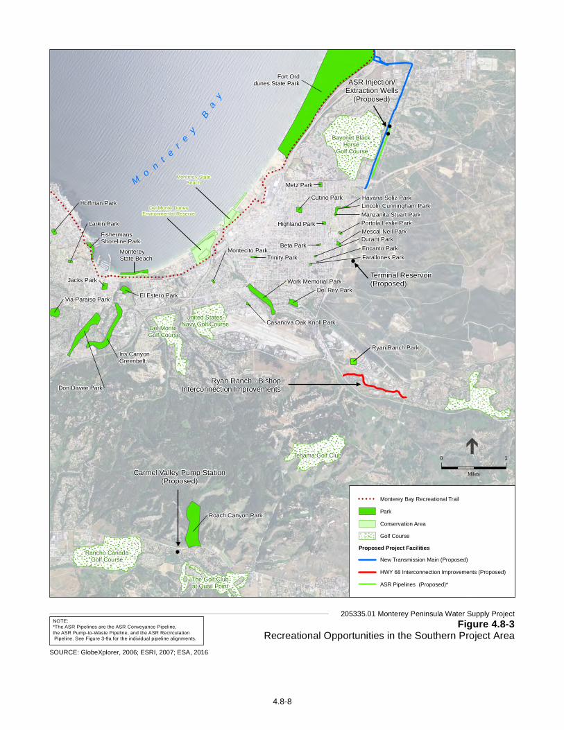
4.8-3 Recreational Opportunities in the Southern Project Area
4.8-1 Overview of Designated Land Uses and Recreational Facilities within 0.25 mile of the Proposed Facilities
4.8-2 Applicable Regional and Local Land Use Plans and Policies Relevant to Land Use and Recreation
4.8-3 Summary of Impacts – Land Use and Recreation
This section analyzes the potential for the Monterey Peninsula Water Supply Project (MPWSP or proposed project) to affect established land uses and recreational facilities, and evaluates project consistency with applicable plans, policies, and ordinances governing land use in the project area. Potential impacts on agricultural land uses are evaluated separately in Section 4.16, Agriculture.
Comments received on the April 2015 Draft EIR related to Land Use, Land Use Planning, and Recreation concern offshore/nearshore and beach recreational uses and access to the Monterey Bay National Marine Sanctuary, the MPWSP’s relationship to and compatibility with Fort Ord Dunes State Park, as well as MPWSP consistency with applicable regulatory requirements. This section has been modified to address these comments. Revisions pertaining to land uses and recreational opportunities are presented in Section 4.8.1, Setting /Affected Environment. Revisions concerning compatibility with applicable regulatory requirements and potential effects of the proposed project are presented in Sections 4.8.2, Regulatory Framework and, 4.8.5, Direct and Indirect Effects of the Proposed Project, respectively.
4.8.1 Setting/Affected Environment The study area for evaluation of land use and recreation impacts includes the lands on which MPWSP facilities are proposed, the adjacent lands, and recreational facilities and resources located within 0.25 mile of the proposed facility sites.
The project area extends approximately 10 miles, from the northern reach of the Castroville Pipeline on Merritt Street in Castroville, to the southern terminus of the new Transmission Main in Seaside, with proposed components extending further south for approximately 6 miles into the Carmel Valley and east to the unincorporated community of Hidden Hills along Highway 68. The project area includes portions of the cities of Marina, Seaside, Monterey, and unincorporated Monterey County, and federal lands (e.g., Presidio of Monterey, the Ord Military Community1). With the exception of the federal lands, land uses in the project area are generally governed by the local coastal programs, general plans, and zoning codes of the local jurisdictions. Land uses on federal lands are governed by the respective managing federal agency (e.g., U.S. Army). 1 These are lands retained by the US government, following the Fort Ord Base Closure and Reuse Plan.
4. Environmental Setting (Affected Environment), Impacts, and Mitigation Measures 4.8 Land Use, Land Use Planning, and Recreation
CalAm Monterey Peninsula Water Supply Project 4.8-2 ESA / 205335.01 Draft EIR/EIS January 2017
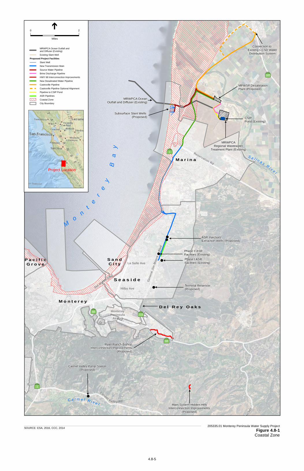
Lands within the former Fort Ord military reservation have mostly been transferred to state and local governments and are now subject to state and local land use plans and regulations. However, local agency land use decisions affecting transferred lands within the former Fort Ord remain subject to discretionary review by the Fort Ord Reuse Authority (FORA).
Land uses in the northern portion of the project area are dominated by agricultural and industrial uses; the remaining portions of the project area are generally urbanized and include residential, commercial, institutional, quasi-public, and industrial land uses. The westernmost portions of the project area lie within the coastal zone, as defined in the California Coastal Act and regulated by the California Coastal Commission (CCC).
There are a variety of recreational resources throughout Monterey County—from federal preserves to state beaches and small neighborhood parks. These resources include the Monterey Bay National Marine Sanctuary (MBNMS), along with designated parks, trails, and open spaces that provide for a diversity of active and passive recreational opportunities. Public access to the area’s unique natural resources is an important component of recreation in Monterey County. The Monterey Bay shoreline hosts one of the most significant and rare dune landforms on the west coast. Public access to beaches, dunes, and hiking trails is available from numerous locations along the coast. There are also several designated bikeways throughout the project area that serve as both recreational facilities and alternative transportation routes.2
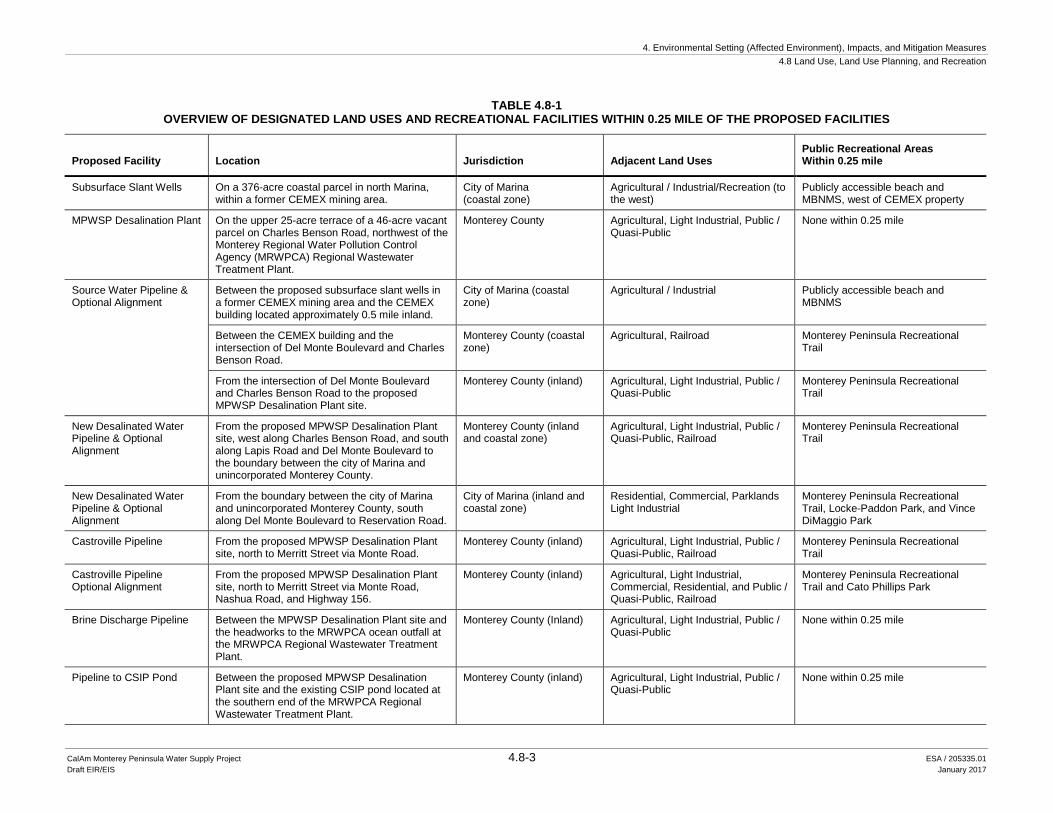
A more detailed overview of existing land uses, land use jurisdictions, and recreational resources adjacent to or within the vicinity (0.25 mile) of MPWSP components is provided in Table 4.8-1 and described below. Many of the proposed project components would be buried entirely underground, and predominantly within existing public rights-of-way and at existing public water/wastewater facility sites. These include the Source Water Pipeline and optional alignment, new Desalinated Water Pipeline and optional alignment, Castroville Pipeline and optional alignments, Brine Discharge Pipeline, Pipeline to CSIP Pond, ASR Conveyance Pipelines, new Transmission Main and optional alignment, Ryan Ranch-Bishop Interconnection Improvements, and Main System-Hidden Hills Interconnection Improvements.
Figure 4.8-1 presents the various local government jurisdictional boundaries and the extent of the coastal zone relative to the project area. Figures 4.8-2 and 4.8-3 present parks and other recreational facilities in the project area.
2 "Bikeway" is a general term used to refer to facilities that provide primarily bicycle travel. The Caltrans Bikeway
Planning and Design section (Chapter 1000 of the State of California Highway Design Manual) categorizes bikeways into three types: • Class I bikeways are bike paths and provide a completely separated right-of-way for the exclusive use of
bicycle and pedestrian traffic with cross-flow minimized. Class I bikeways exist along General Jim Moore Boulevard between Normandy Road and Coe Avenue. The Monterey Peninsula Recreational Trail (also known as the Monterey Bay Coastal Trail), which extends approximately 18 miles between Castroville and Pacific Grove, is also a Class I bikeway.
• Class II bikeways are bike lanes and are indicated by a striped lane for one-way bike travel on a street or highway, typically with signage placed along the street segment. A Class II bikeway exists along General Jim Moore Boulevard between Coe Avenue and Canyon del Rey Boulevard.
• Class III bikeways are bike routes that involve shared use of the roadway with motor vehicle traffic. Typically these facilities are city streets with signage indicating the designated bike route without additional striping or improvements for bicyclists.
4. Environmental Setting (Affected Environment), Impacts, and Mitigation Measures 4.8 Land Use, Land Use Planning, and Recreation
CalAm Monterey Peninsula Water Supply Project 4.8-3 ESA / 205335.01 Draft EIR/EIS January 2017
TABLE 4.8-1 OVERVIEW OF DESIGNATED LAND USES AND RECREATIONAL FACILITIES WITHIN 0.25 MILE OF THE PROPOSED FACILITIES
Proposed Facility Location Jurisdiction Adjacent Land Uses Public Recreational Areas Within 0.25 mile
Subsurface Slant Wells On a 376-acre coastal parcel in north Marina, within a former CEMEX mining area.
City of Marina (coastal zone)
Agricultural / Industrial/Recreation (to the west)
Publicly accessible beach and MBNMS, west of CEMEX property
MPWSP Desalination Plant On the upper 25-acre terrace of a 46-acre vacant parcel on Charles Benson Road, northwest of the Monterey Regional Water Pollution Control Agency (MRWPCA) Regional Wastewater Treatment Plant.
Monterey County Agricultural, Light Industrial, Public / Quasi-Public
None within 0.25 mile
Source Water Pipeline & Optional Alignment
Between the proposed subsurface slant wells in a former CEMEX mining area and the CEMEX building located approximately 0.5 mile inland.
City of Marina (coastal zone)
Agricultural / Industrial Publicly accessible beach and MBNMS
Between the CEMEX building and the intersection of Del Monte Boulevard and Charles Benson Road.
Monterey County (coastal zone)
Agricultural, Railroad Monterey Peninsula Recreational Trail
From the intersection of Del Monte Boulevard and Charles Benson Road to the proposed MPWSP Desalination Plant site.
Monterey County (inland) Agricultural, Light Industrial, Public / Quasi-Public
Monterey Peninsula Recreational Trail
New Desalinated Water Pipeline & Optional Alignment
From the proposed MPWSP Desalination Plant site, west along Charles Benson Road, and south along Lapis Road and Del Monte Boulevard to the boundary between the city of Marina and unincorporated Monterey County.
Monterey County (inland and coastal zone)
Agricultural, Light Industrial, Public / Quasi-Public, Railroad
Monterey Peninsula Recreational Trail
New Desalinated Water Pipeline & Optional Alignment
From the boundary between the city of Marina and unincorporated Monterey County, south along Del Monte Boulevard to Reservation Road.
City of Marina (inland and coastal zone)
Residential, Commercial, Parklands Light Industrial
Monterey Peninsula Recreational Trail, Locke-Paddon Park, and Vince DiMaggio Park
Castroville Pipeline From the proposed MPWSP Desalination Plant site, north to Merritt Street via Monte Road.
Monterey County (inland) Agricultural, Light Industrial, Public / Quasi-Public, Railroad
Monterey Peninsula Recreational Trail
Castroville Pipeline Optional Alignment
From the proposed MPWSP Desalination Plant site, north to Merritt Street via Monte Road, Nashua Road, and Highway 156.
Monterey County (inland) Agricultural, Light Industrial, Commercial, Residential, and Public / Quasi-Public, Railroad
Monterey Peninsula Recreational Trail and Cato Phillips Park
Brine Discharge Pipeline Between the MPWSP Desalination Plant site and the headworks to the MRWPCA ocean outfall at the MRWPCA Regional Wastewater Treatment Plant.
Monterey County (Inland) Agricultural, Light Industrial, Public / Quasi-Public
None within 0.25 mile
Pipeline to CSIP Pond Between the proposed MPWSP Desalination Plant site and the existing CSIP pond located at the southern end of the MRWPCA Regional Wastewater Treatment Plant.
Monterey County (inland) Agricultural, Light Industrial, Public / Quasi-Public
None within 0.25 mile
4. Environmental Setting (Affected Environment), Impacts, and Mitigation Measures 4.8 Land Use, Land Use Planning, and Recreation
CalAm Monterey Peninsula Water Supply Project 4.8-4 ESA / 205335.01 Draft EIR/EIS January 2017
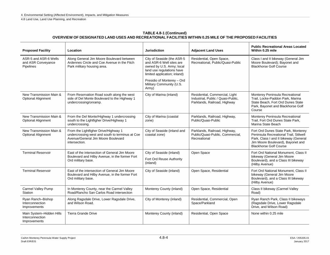
TABLE 4.8-1 (Continued) OVERVIEW OF DESIGNATED LAND USES AND RECREATIONAL FACILITIES WITHIN 0.25 MILE OF THE PROPOSED FACILITIES
Proposed Facility Location Jurisdiction Adjacent Land Uses Public Recreational Areas Located Within 0.25 mile
ASR-5 and ASR-6 Wells and ASR Conveyance Pipelines
Along General Jim Moore Boulevard between Ardennes Circle and Coe Avenue in the Fitch Park military housing area.
City of Seaside (the ASR-5 and ASR-6 Well sites are owned by U.S. Army; local land use regulations have limited application; inland) Presidio of Monterey – Ord Military Community (U.S. Army)
Residential, Open Space, Recreational, Public/Quasi-Public
Class I and II bikeway (General Jim Moore Boulevard); Bayonet and Blackhorse Golf Course
New Transmission Main & Optional Alignment
From Reservation Road south along the west side of Del Monte Boulevard to the Highway 1 undercrossing/onramp.
City of Marina (inland) Residential, Commercial, Light Industrial, Public / Quasi-Public, Parklands, Railroad, Highway
Monterey Peninsula Recreational Trail, Locke-Paddon Park, Marina State Beach, Fort Ord Dunes State Park, Bayonet and Blackhorse Golf Course
New Transmission Main & Optional Alignment
From the Del Monte/Highway 1 undercrossing south to the Lightfigher Drive/Highway 1 undercrossing.
City of Marina (coastal zone)
Parklands, Railroad, Highway, Public/Quasi-Public
Monterey Peninsula Recreational Trail, Fort Ord Dunes State Park, Marina State Beach
New Transmission Main & Optional Alignment
From the Lightfigher Drive/Highway 1 undercrossing west and south to terminus at Coe Avenue/General Jim Moore Boulevard intersection.
City of Seaside (inland and coastal zone)
Parklands, Railroad, Highway, Public/Quasi-Public, Commercial, Recreational
Fort Ord Dunes State Park, Monterey Peninsula Recreational Trail, Stilwell Park, Class I and II bikeway (General Jim Moore Boulevard), Bayonet and Blackhorse Golf Course
Terminal Reservoir East of the intersection of General Jim Moore Boulevard and Hilby Avenue, in the former Fort Ord military base.
City of Seaside (inland)
Fort Ord Reuse Authority (inland)
Open Space Fort Ord National Monument, Class II bikeway (General Jim Moore Boulevard), and a Class III bikeway (Hilby Avenue)
Terminal Reservoir East of the intersection of General Jim Moore Boulevard and Hilby Avenue, in the former Fort Ord military base.
City of Seaside (inland) Open Space, Residential Fort Ord National Monument, Class II bikeway (General Jim Moore Boulevard), and a Class III bikeway (Hilby Avenue)
Carmel Valley Pump Station
In Monterey County, near the Carmel Valley Road/Rancho San Carlos Road intersection
Monterey County (inland) Open Space, Residential Class II bikeway (Carmel Valley Road)
Ryan Ranch–Bishop Interconnection Improvements
Along Ragsdale Drive, Lower Ragsdale Drive, and Wilson Road.
City of Monterey (inland) Residential, Commercial, Open Space/Parkland
Ryan Ranch Park, Class II bikeways (Ragsdale Drive, Lower Ragsdale Drive, and Wilson Road)
Main System–Hidden Hills Interconnection Improvements
Tierra Grande Drive Monterey County (inland) Residential, Open Space None within 0.25 mile
ASR Injection/Extraction Wells (Proposed)
Terminal Reservoir(Proposed)
MRWPCA OceanOutfall and Diffuser (Existing)
MRWPCARegional Wastewater
Treatment Plant (Existing)
Carmel Valley Pump Station(Proposed)
Subsurface Slant Wells (Proposed)
Mo n
t er
ey
Ba
y
MPWSP DesalinationPlant (Proposed)
CSIPPond (Existing)
!!
!
Reservation Rd
Gene
ral Ji
m Mo
ore
Blvd
La Salle Ave
Hilby AveDel Monte Blvd
C a r m e l R i v e r
Ryan Ranch-BishopInterconnection Improvements
(Proposed)
Main System-Hidden HillsInterconnection Improvements
(Proposed)
S a l i n a s R i v e r
Phase I ASR Facilities (Existing)
!
Phase II ASRFacilities (Existing)!
MontereyPeninsula
Airport
Carmel Valley Rd
Laur
elsGr
ade
S a n dC i t y
Connection to Existing CCSD WaterDistribution System
M a r i n a
M o n t e r e y
S e a s i d e
P a c i f i cG r o v e
D e l R e y O a k s
ÄÅ1
ÄÅ218
ÄÅ183
ÄÅ1
ÄÅ68
ÄÅ68
SOURCE: ESA, 2016, CCC, 2014
MRWPCA Ocean Outfall andand Diffuser (Existing)Existing Slant Well
Proposed Project FacilitiesSlant WellNew Transmission MainSource Water PipelineBrine Discharge PipelineHWY 68 Interconnection ImprovementsNew Desalinated Water PipelineCastroville PipelineCastroville Pipeline Optional AlignmentPipeline to CSIP PondASR Pipelines Coastal ZoneCity Boundary
0 2
Miles
Project Location
205335.01 Monterey Peninsula Water Supply ProjectFigure 4.8-1
Coastal Zone
4.8-5

4. Environmental Setting (Affected Environment), Impacts, and Mitigation Measures 4.8 Land Use, Land Use Planning, and Recreation
CalAm Monterey Peninsula Water Supply Project 4.8-6 ESA / 205335.01 Draft EIR/EIS January 2017
This page intentionally left blank
MRWPCARegional WastewaterTreatment Plant (Existing)
MPWSP DesalinationPlant (Proposed)
Subsurface Slant Wells (Proposed)
Marina State Beach
Locke Paddon Park
Preston Park
Vince DiMaggio Park
Glorya Jean Tate Park
WindyhillPark
Japanese School Park
Salinas River State Beach
Bayonet Black Horse
Golf Course
S a l i n a s R i v e r
MRWPCA OceanOutfall and Diffuser (Existing)
Fort Ord DunesState Park
Abrams Park
!!
Injection/Extraction Wells(Proposed)
Salinas River Wildlife Refuge
SOURCE: GlobeXplorer, 2006; ESRI, 2007; ESA, 2016
Monterey Bay Recreational Trail
Park
Conservation Area
Golf Course
MRWPCA Ocean Outfall and Diffuser (Existing)
Proposed Project FacilitiesNew Transmission Main (Proposed)
Source Water Pipeline (Proposed)
Brine Discharge Pipeline (Proposed)
New Desalinated Water Pipeline (Proposed)
Castroville Pipeline (Proposed)
Castroville Pipeline Optional Alignment (Proposed)
Pipeline to CSIP Pond (Proposed)
ASR Pipelines (Proposed) *
205335.01 Monterey Peninsula Water Supply ProjectFigure 4.8-2
Recreational Opportunities in the Northern Project AreaNOTE:*The ASR Pipelines are the ASR Conveyance Pipeline,the ASR Pump-to-Waste Pipeline, and the ASR Recirculation Pipeline. See Figure 3-9a for the individual pipeline alignments.
4.8-7
!
!
!
!
Carmel Valley Pump Station(Proposed)
Rancho CanadaGolf Course
The Golf Clubat Quail Point
Ryan Ranch - BishopInterconnection Improvements
M o n t e r e yB
ay
Ryan Ranch Park
ASR Injection/Extraction Wells
(Proposed)
Terminal Reservoir (Proposed)
Bayonet Black Horse
Golf Course
Tehama Golf Club
Del Monte Golf Course
United States Navy Golf Course
Del Monte DunesEnvironmental Reserve
Monterey StateBeach
Fort Orddunes State Park
Roach Canyon Park
Don Davee Park
Iris CanyonGreenbelt
Work Memorial Park
Via Paraiso ParkEl Estero Park
Jacks Park
Del Rey Park
MontereyState Beach
Cutino Park
Fishermans Shoreline Park
Hoffman Park
Metz Park
Larkin ParkMescal Neil Park
Trinity Park
Highland Park
Lincoln Cunningham Park
Montecito Park
Portola Leslie Park
Durant Park
Farallones Park
Casanova Oak Knoll Park
Beta Park
Havana Soliz Park
Manzanita Stuart Park
Encanto Park
0 1
Miles
Monterey Bay Recreational Trail
Park
Conservation Area
Golf Course
Proposed Project FacilitiesNew Transmission Main (Proposed)
HWY 68 Interconnection Improvements (Proposed)
ASR Pipelines (Proposed)*
SOURCE: GlobeXplorer, 2006; ESRI, 2007; ESA, 2016
205335.01 Monterey Peninsula Water Supply ProjectFigure 4.8-3
Recreational Opportunities in the Southern Project AreaNOTE:*The ASR Pipelines are the ASR Conveyance Pipeline,the ASR Pump-to-Waste Pipeline, and the ASR Recirculation Pipeline. See Figure 3-9a for the individual pipeline alignments.
4.8-8
4. Environmental Setting (Affected Environment), Impacts, and Mitigation Measures 4.8 Land Use, Land Use Planning, and Recreation
CalAm Monterey Peninsula Water Supply Project 4.8-9 ESA / 205335.01 Draft EIR/EIS January 2017
4.8.1.1 Subsurface Slant Wells Land Use. A portion of the subsurface slant wells would be constructed above the maximum high-tide elevation, within the 376-acre CEMEX sand mining facility located on the coast in north Marina (Figure 3-3). CEMEX owns the coastal land above mean high tide; the California State Lands Commission owns the land below mean high tide. The sand mining operations at the CEMEX facility have been in existence since 1906. The sand mining facility is bounded to the west by beach and the Pacific Ocean, to the north and south by vegetated sand dunes, and to the east by open space, grazing and croplands, and Highway 1.
Recreation. The beach bordering the western edge of the CEMEX property is publicly accessible from paths to the beach which are located off public roads approximately 1 mile south at Marina Dunes Preserve and 1.25 miles north at the Salinas River National Wildlife Refuge. The Monterey Peninsula Recreational Trail is located approximately 1 mile east of the slant well site. The CEMEX property abuts the mean high water line representing the boundary of MBNMS, which extends out to approximately 30 miles offshore, and provides for a diversity of recreational opportunities, including swimming, kayaking, fishing, surfing, scuba diving, wildlife viewing, among many others. There are no other recreational resources on the site of the subsurface slant wells.
4.8.1.2 MPWSP Desalination Plant Land Use. The MPWSP Desalination Plant would be constructed on an upper 25-acre portion of a 46-acre vacant parcel located on Charles Benson Road, in unincorporated Monterey County (see Figure 3-5). The site of the proposed MPWSP Desalination Plant is bounded to the west and north by open space, grazing, and agricultural lands, and to the east and south by public facility and industrial uses at the Monterey County Landfill and the Monterey Regional Water Pollution Control Agency (MRWPCA) Regional Wastewater Treatment Plant.
Recreation. There are no parks or recreational facilities in the vicinity of the MPWSP Desalination Plant site.
4.8.1.3 Source Water Pipeline Land Use. The Source Water Pipeline would traverse portions of northern Marina and unincorporated Monterey County (see Figures 3-3, 3-4, and 3-5). Lands adjacent to the proposed and optional alignments are used primarily for open space, grazing, and row crop farming, agricultural operations, and public/quasi-public uses (e.g. Monterey County Landfill and The Last Chance Mercantile Reuse Store).
Recreation. The Source Water Pipeline and optional alignment would cross the Monterey Peninsula Recreational Trail at the intersection of Del Monte Boulevard and Charles Benson Road. There are no parks or other recreational facilities in the vicinity of the proposed Source Water Pipeline alignment.
4. Environmental Setting (Affected Environment), Impacts, and Mitigation Measures 4.8 Land Use, Land Use Planning, and Recreation
CalAm Monterey Peninsula Water Supply Project 4.8-10 ESA / 205335.01 Draft EIR/EIS January 2017
4.8.1.4 New Desalinated Water Pipeline Land Use. The approximately 0.8-mile segment of the new Desalinated Water Pipeline between Del Monte Boulevard and the proposed MPWSP Desalination Plant site would be co-located with the Source Water Pipeline and the Castroville Pipeline and follow one of the two routes (proposed or optional alignments). The northern portion of the proposed alignment would cross both coastal and inland portions of unincorporated Monterey County; in the vicinity of Lapis Road and Del Monte Boulevard, the pipeline would be constructed within the Transportation Agency for Monterey County (TAMC) right-of-way (see Figures 3-4, 3-5 and 3-6).
Land uses in the vicinity of the Monterey County portion of the proposed new Desalinated Water Pipeline and optional alignment include primarily open space, grazing, and row crop farming, and public/quasi-public uses. The southern portion of the proposed alignment crosses portions of inland and coastal Marina (see Figures 3-6 and 3-7). Land uses in the vicinity of the Marina segment of the proposed new Desalinated Pipeline and optional alignment include residential, light industrial, commercial, parks, and public facilities.
Recreation. The new Desalinated Water Pipeline and optional alignment would cross the Monterey Peninsula Recreational Trail at the intersection of Del Monte Boulevard and Charles Benson Road. In addition, the segment between the Lapis Road/Del Monte Boulevard (southern) intersection and Del Monte Boulevard Reservation Road intersection would be constructed parallel to and west of the Monterey Peninsula Recreational Trail. Locke-Paddon (within Marina’s coastal zone) and Vince DiMaggio Parks are located adjacent to the west and east, respectively, of the new Desalinated Water Pipeline proposed and optional alignment near its junction with the transmission main at Reservation Road.
4.8.1.5 Castroville Pipeline Land Use. The Castroville Pipeline would be constructed within unincorporated Monterey County. The segment of the proposed alignment extending from Del Monte Boulevard to the CCSD Well #3 on Merritt Street would follow the TAMC right-of-way along Monte Road. The Castroville Pipeline Optional Alignment 1 would follow other public rights-of-way (see Figures 3-11 and 3-12). Land uses in the vicinities of both alignment options are predominantly agricultural, with adjacent lands primarily used for row crop production and grazing. Public and quasi-public and light industrial (e.g., Monterey County Landfill and former Dole Fresh Vegetables packaging plant) also occur along the proposed and optional alignments. Residential and commercial land uses are more prevalent along the segment of the Castroville Pipeline Optional Alignment 1 that extends along Merritt Street in Castroville.
Recreation. The Castroville Pipeline and Castroville Pipeline Optional Alignment 1 would cross the Monterey Peninsula Recreational Trail at the intersection of Del Monte Boulevard and Charles Benson Road. In addition, the segment of the Castroville Pipeline Optional Alignment 1 along Highway 156 between the Nashua Road and Merritt Street would be constructed parallel to and west of the Monterey Peninsula Recreational Trail. Optional alignment 1 would also pass within 0.25 mile of Cato Phillips Park.
4. Environmental Setting (Affected Environment), Impacts, and Mitigation Measures 4.8 Land Use, Land Use Planning, and Recreation
CalAm Monterey Peninsula Water Supply Project 4.8-11 ESA / 205335.01 Draft EIR/EIS January 2017
4.8.1.6 Brine Discharge Pipeline Land Use. The Brine Discharge Pipeline would extend from the MPWSP Desalination Plant to a new connection with the MPWPCA outfall at the existing MRWPCA Regional Wastewater Treatment Plant (see Figure 3-5). The proposed pipeline alignment is within unincorporated Monterey County. Lands in the vicinity of the Brine Discharge Pipeline alignment are used for open space, grazing, and the industrial operations of the Monterey County Landfill and MRWPCA Regional Wastewater Treatment Plant.
Recreation. There are no parks or recreational facilities in the vicinity of the proposed Brine Discharge Pipeline alignment.
4.8.1.7 Pipeline to CSIP Pond Land Use. The Pipeline to CSIP Pond would extend from the MPWSP Desalination Plant to a point of connection with the Castroville Seawater Intrusion Project, located within the MRWPCA Regional Wastewater Treatment Plant (see Figure 3-5). The proposed alignment is within unincorporated Monterey County. As with the Brine Discharge Pipeline, lands adjacent to the Pipeline to CSIP Pond alignment are used for open space, grazing, and the Monterey County Landfill and MRWPCA Regional Wastewater Treatment Plant.
Recreation. There are no parks or recreational facilities in the vicinity of the proposed Pipeline to CSIP Pond alignment.
4.8.1.8 Aquifer Storage and Recovery Facilities Land Use. The proposed ASR injection/extraction wells (ASR-5 and ASR-6 Wells) would be located east of General Jim Moore Boulevard and south of Ardennes Circle, in the Fitch Park military housing area (Figure 3-9). These MPWSP components would be constructed in the former Fort Ord military base (Ord Military Community) on land owned by the U.S. Army. The sites of the proposed facilities are presently undeveloped. The ASR-5 and ASR-6 Wells would be constructed within 50 feet of existing residences. The ASR Recirculation Pipeline, ASR Conveyance Pipeline, and ACR Pump-to-Waste Pipeline (ASR pipelines) would be installed within the General Jim Moore Boulevard right-of-way, within city of Seaside jurisdiction. The alignment would connect the proposed ASR-5 and ASR-6 Wells with existing infrastructure near the General Jim Moore/Coe Avenue intersection. Land uses in the vicinity of these facilities are predominantly residential, recreational (e.g., Bayonet and Black Horse Golf Courses), and public/quasi-public (e.g., Seaside Middle School) in nature.
Recreation. Class I and II bikeways exists along General Jim Moore Boulevard, between Coe Avenue and Normandy Road. The ASR injection/extraction well sites and pipeline alignments occur within 0.25 miles of the Bayonet and Blackhorse Golf Courses.
4. Environmental Setting (Affected Environment), Impacts, and Mitigation Measures 4.8 Land Use, Land Use Planning, and Recreation
CalAm Monterey Peninsula Water Supply Project 4.8-12 ESA / 205335.01 Draft EIR/EIS January 2017
4.8.1.9 New Transmission Main Land Use. The new Transmission Main and optional alignment would extend approximately 6 miles from the new Desalinated Water Pipeline connection at the intersection of Del Monte Boulevard and Reservation Road in Marina to a connection with existing infrastructure near the General Jim Moore/Coe Avenue intersection (Figures 3-7, 3-8, and 3-9). Portions of the proposed and optional pipeline alignments would be located within the Marina and Seaside land use jurisdictions. Land use patterns along the alignment east of Highway 1 are within Marina, and are defined primarily by medium-density commercial and residential development. Public and quasi-public land uses also occur in this area (e.g., Marina Del Mar Elementary School). West of Highway 1, the pipeline would be constructed within the TAMC right-of-way. Land uses in this area include parklands and railroad to the west and highway to the east. Land use patterns along the alignment east of Highway 1 within Seaside are predominantly residential, recreational (e.g., Bayonet and Black Horse Golf Courses), public/quasi-public (e.g., CSUMB and Dual Language Academy of the Monterey Peninsula, and Ord Military Community).
Recreation. The segment of the new Transmission Main and optional alignment between the Del Monte Boulevard/Reservation Road intersection and Highway 1/Lightfigher Drive undercrossing would be constructed parallel to and west of the Monterey Peninsula Recreational Trail. The pipeline would also pass within 0.25 mile of Bayonet and Black Horse Golf Courses, Locke-Paddon Park, Marina State Beach, Fort Ord Dunes State Park, Stilwell Park, Monterey Peninsula Recreational Trail, and Class I and II bikeways (General Jim Moore Boulevard).
4.8.1.10 Terminal Reservoir Land use. The proposed Terminal Reservoir would be located east of General Jim Moore Boulevard, approximately 0.3 mile north of Watkins Gate Road in a mostly undeveloped area (with the exception of a dirt access road and utilities) of the former Fort Ord military base, within the city of Seaside (Figure 3-9). The Bureau of Land Management (BLM) manages 14,600 acres of land to the east of the site, known as the BLM Natural Resource Management Area.
Recreation. A Class II bikeway exists along General Jim Moore Boulevard between Coe Avenue and Canyon Del Rey Boulevard. There are no existing parks adjacent to the proposed Terminal Reservoir site. However, the lands immediately north of the site are designated for Parks and Open Space (POS) and zoned for Open Space and Recreation (OSR) (City of Seaside, 2004a; 2010). To the east of the Terminal Reservoir site is the Fort Ord National Monument. Comprised of former Fort Ord military reservation lands, a substantial portion of this National Monument, including the portion nearest the Terminal Reservoir site, remains under U.S. Army management and is closed to the public due to munitions hazards. However, approximately 3 miles north and east of the Terminal Reservoir site, the public has access to roughly 86 miles of hiking trails over some 7,200 acres of the portion of Fort Ord National Monument under the BLM’s authority (BLM, 2012; 2014).
4. Environmental Setting (Affected Environment), Impacts, and Mitigation Measures 4.8 Land Use, Land Use Planning, and Recreation
CalAm Monterey Peninsula Water Supply Project 4.8-13 ESA / 205335.01 Draft EIR/EIS January 2017
4.8.1.11 Carmel Valley Pump Station Land Use. The Carmel Valley Pump Station would be located approximately 250 feet south of Carmel Valley Road and 500 feet west of Rancho San Carlos Road, in unincorporated Monterey County (Figure 3-10c). Land uses in the vicinity of the pump station site include low density residential development and open space.
Recreational. A Class II bikeway exists along Carmel Valley Road.
4.8.1.12 Interconnection Improvements for Highway 68 Satellite Systems
Land Use. The Ryan Ranch–Bishop Interconnection Improvements would be located within the city of Monterey adjacent to lands used for office park, light industrial, and parks and open space (Figure 3-10a). The proposed Main System–Hidden Hills Interconnection Improvements would be located in unincorporated Monterey County adjacent to low-density residential development, surrounded by open space (Figure 3-10b).
Recreation. The proposed Ryan Ranch–Bishop Interconnection Improvements would be located adjacent to Ryan Ranch Park (accessible via Ryan Ranch Road), an open space area with a network of unpaved hiking trails that is managed by the City of Monterey Parks Department. Class II bikeways also exist along Ragsdale Drive, Lower Ragsdale Drive, and Wilson Road. The Laguna Seca Recreation Area is within 3 miles of the proposed Main System–Hidden Hills Interconnection Improvements.
4.8.2 Regulatory Framework This section provides an overview of applicable federal, state, and local environmental laws, policies, plans, regulations, and/or guidelines (hereafter referred to generally as “regulatory requirements”) relevant to land use and recreational resources. A brief summary of each is provided, along with a finding regarding the project’s conformity with those regulatory requirements. The conformity findings concern the project as proposed, without mitigation. Where the project, as proposed, would be consistent with the applicable regulatory requirement, no further discussion of project consistency with that regulatory requirement is provided. Where the project, as proposed, would be potentially inconsistent with the applicable regulatory requirement, the reader is referred to a specific impact topic within EIR/EIS Section 4.8.5, Direct and Indirect Effects of the Project, where the potential inconsistency is addressed in more detail. Where applicable, the discussion in Section 4.8.5 includes the identification of feasible mitigation that would resolve or minimize the potential inconsistency.
4.8.2.1 Federal Regulations
Marine Protection, Research, and Sanctuaries Act of 1972
The Marine Protection, Research, and Sanctuaries Act of 1972, also known as the National Marine Sanctuaries Act (Act), provides for the identification, designation, and management of
4. Environmental Setting (Affected Environment), Impacts, and Mitigation Measures 4.8 Land Use, Land Use Planning, and Recreation
CalAm Monterey Peninsula Water Supply Project 4.8-14 ESA / 205335.01 Draft EIR/EIS January 2017
marine areas that are of special significance due to their recreational, ecological, historical, research, educational, or aesthetic qualities. Accordingly, a primary purpose of the Act’s implementing regulations (15 CFR 922) is to protect, preserve, and manage recreational resources of national marine sanctuaries. The importance of recreation is further emphasized in the 2008 MBNMS Final Management Plan, which includes a desalination action plan and strategies to guide siting and development of desalination projects in a manner that is protective of MBNMS resources, including recreational opportunities. In addition, MBNMS worked with the National Marine Fisheries Service (NMFS) to develop desalination guidelines (NOAA, 2010). See EIR/EIS Section 6.4, Project Consistency with Monterey Bay National Marine Sanctuary Desalination Guidelines, for additional discussion.
Activities that would be subject to MBNMS jurisdiction, which extends seaward from the mean high water line out to approximately 30 miles, are generally limited to drilling the subsurface seawater intake pipelines into the submerged lands of MBNMS, and the discharge of brine from an existing ocean outfall, which is approximately two miles off shore and 90-110 feet below sea level. No MPWSP facilities are proposed for or would involve construction that would impede access to, or use of the MBNMS as a recreational resource. As proposed, implementation and operation of the MPWSP could have water quality and marine biological resources impacts that could affect recreational opportunities. Additional discussion of MPWSP effects related to water quality and marine biological resources is provided in EIR/EIS Section 4.3, Surface Water Hydrology and Water Quality, and Section 4.5, Marine Biological Resources.
Coastal Zone Management Act
The Coastal Zone Management Act (CZMA) of 1972 provides for management of the nation’s coastal resources, including the Great Lakes, and balances economic development with environmental conservation. The California Coastal Commission has jurisdiction for CZMA implementation throughout the state.3 The California Coastal Act contains numerous enforceable policies that are directed at protecting and, where feasible, restoring coastal resources. The California Coastal Commission applies the Coastal Act’s policies when reviewing applications for coastal development permits in California state waters. The Coastal Commission also applies land use policies when reviewing federally licensed and permitted activities to ensure they are consistent with the State’s coastal management program in accordance with the CZMA federal consistency provision. The Coastal Commission considers an application for a coastal development permit to cover the requirement for an applicant submitting a consistency certification to the Coastal Commission. Typically, the Coastal Commission will provide its response (concurrence, conditional concurrence, or objection) in its staff report for the coastal development permit.
Real Property Master Plan – Presidio of Monterey
The U.S. Army’s 1983 Real Property Master Plan – Presidio of Monterey provides for the orderly development and maintenance of land, facilities, and infrastructure within the Presidio of Monterey Installation, which includes the Presidio of Monterey and the Ord Military Community. 3 Except within the San Francisco Bay-Delta where the Bay Conservation and Development Commission has
authority for implementation of CZMA within its jurisdictional area.
4. Environmental Setting (Affected Environment), Impacts, and Mitigation Measures 4.8 Land Use, Land Use Planning, and Recreation
CalAm Monterey Peninsula Water Supply Project 4.8-15 ESA / 205335.01 Draft EIR/EIS January 2017
The Master Plan depicts Army Land Use Categories assigned to lands within these military planning areas. Use categories identified within these military planning areas include: Community, Professional/Institutional, Troop, and Residential. The Master Plan also describes the types of uses appropriate within each category. The document does not prohibit development of utilities in any of the land use categories. In February 2013, the U.S. Army Corps of Engineers completed an environmental impact statement (EIS) analyzing the potential environmental consequences of implementing a revised Real Property Master Plan. The EIS evaluated three alternatives for the Real Property Master Plan. The alternatives focus almost entirely on facilities improvements and new construction and would not involve revisions to existing land use designations. The U.S. Army is in the process of revising the Real Property Master Plan, based upon the findings of the EIS. The completion date for the revised Real Property Master Plan remains unknown. Elements of the project subject to the Real Property Master Plan include the ASR-5 and ASR-6 Wells. In 2010 and 2012, the U.S. Army prepared NEPA environmental assessments (EAs) analyzing the potential land use effects of the ASR-5 and ASR-6 wells proposed for the Presidio of Monterey. The EAs concluded that the proposed MPWSP facilities would have no impact with respect to conflict with any applicable land use plans, policies, or regulations (RBF Consulting, 2010; 2012).
4.8.2.2 State Regulations
Fort Ord Reuse Authority and Fort Ord Reuse Plan
The 1994 Fort Ord Reuse Authority Act (California Government Code section 67650-67700); hereafter referred to as the “FORA Act”) was passed with the goals of facilitating the transfer, reuse, and management of lands within the former Fort Ord military reservation. Pursuant to the Act, on May 20, 1994, the Fort Ord Reuse Authority (FORA) was established as a corporation of the State of California. The purpose of the FORA is to prepare, adopt, finance, and implement a plan for the land formerly occupied by Fort Ord. The FORA is governed by a 13-member board (FORA Board) comprised of representatives from the Monterey County Board of Supervisors, and city council members from each of the cities of Marina, Seaside, Carmel, Del Rey Oaks, Sand City, Monterey, Pacific Grove, and Salinas (member agencies). The FORA Act directs the Board to prepare and adopt a plan (Reuse Plan) for the future use and development of lands within the former Fort Ord Territory (FORA, 1997a).
The FORA Act requires that, with a few exceptions for universities, all Fort Ord land that has been transferred from the federal government must be used in a manner consistent with the Reuse Plan. This provision is affirmed and explained further in the Fort Ord Master Resolution, adopted in March of 1997 (FORA, 1997b). For member agencies with jurisdiction over lands within the former Fort Ord territory, the Master Resolution (Section 8.01.010(c)) requires all general plans, and “all policies and programs relating to the land use or the construction, installation, or maintenance of capital improvements or public works within the Fort Ord Territory, shall be consistent with the Reuse Plan…” Before any such plans or regulations may take effect, the member agency must first obtain from the FORA Board a determination that the plan or regulation is consistent with the Reuse Plan. Upon certification by the Board, development review authority is transferred to the member agency with jurisdiction over the FORA lands.
4. Environmental Setting (Affected Environment), Impacts, and Mitigation Measures 4.8 Land Use, Land Use Planning, and Recreation
CalAm Monterey Peninsula Water Supply Project 4.8-16 ESA / 205335.01 Draft EIR/EIS January 2017
However, pursuant to the FORA Act and Master Resolution (Section 8.01.030(c)), after certification of said general plan, policies, and programs, the Board may continue to review for consistency member agencies’ development entitlement decisions in the former Fort Ord territory (FORA, 1997b).
The Fort Ord Reuse Plan, adopted in 1997, includes the information normally found in a general plan. It establishes the general plan context and rationale, addressing matters of community visioning, existing setting, use concepts, and implementation; and includes the Reuse Plan Elements, setting forth goals, objectives, policies, and programs by land use and jurisdiction for land use, circulation, recreation and open space, conservation, noise, and safety (FORA, 1997a).
MPWSP components proposed within former Fort Ord territory and subject to the Reuse Plan include the Terminal Reservoir (which would be located within Seaside’s jurisdiction and subject to Seaside approvals), and a segment of the Ryan Ranch-Bishop Interconnection Improvements (which would occur within Monterey County’s jurisdiction and subject to Monterey County’s approvals). However, as noted above, the FORA Board may, at its discretion, decide to review local decisions with respect to Fort Ord Reuse plan consistency. Preliminary determinations by the EIR preparers regarding MPWSP consistency with the Reuse Plan policies related to land use and recreation are presented in Table 4.8-2. Analyses of consistency with Reuse Plan policies related to other topics presented in their respective topical sections of this EIR/EIS.
Fort Ord Dunes State Park General Plan
The Fort Ord Dunes State Park General Plan (General Plan) outlines the purpose and vision for the park; and sets forth management goals and guidelines for protection of the natural environment; resource restoration; and for the siting, design, and construction of future park improvements in a manner that avoids environmental effects. Prominent among the General Plan’s guiding principles (and indeed the mission of California Department of Parks and Recreation) is the provision and management of recreational opportunities consistent with resource management and protection. The new Transmission Main and optional alignment would traverse an approximately 0.25 band of Fort Ord Dunes State Park lands between Divarty Street/1st Street and the alignments’ Highway 1 undercrossing near Lightfighter Drive. The pipeline segment proposed for State Parks lands would be sited between the Monterey Peninsula Recreational Trail and the existing railroad. This area is presently inaccessible to the public, as the alignment area is fenced. Pipeline installation would temporarily disturb this area during construction, but would then be returned to its approximate pre-construction condition. As a result, new Transmission Main pipeline construction activities within Fort Ord Dunes State Park would not conflict with General Plan goals or guidelines related to recreation. Additional discussion of effects on Fort Ord Dunes State Park access is provided in Impacts 4.8-1 and 4.8-2.
California Coastal Act
The California Coastal Act (Public Resources Code Section 30000 et seq.) was enacted by the State Legislature in 1976 to provide long-term protection of the State’s 1,100-mile coastline for the benefit of current and future generations. The Coastal Act provides for the long-term
4. Environmental Setting (Affected Environment), Impacts, and Mitigation Measures 4.8 Land Use, Land Use Planning, and Recreation
CalAm Monterey Peninsula Water Supply Project 4.8-17 ESA / 205335.01 Draft EIR/EIS January 2017
management of lands within California’s coastal zone boundary, as established by the Legislature and defined in Coastal Act (Section 30103). The width of the coastal zone varies across the State, extending inland a couple hundred feet in some locations to 5 miles in others, and offshore out to 3 miles. A map of the coastal zone in the project vicinity is shown in Figure 4.8-1.
The Coastal Act created a unique partnership between the State (acting through the CCC) and local government entities (15 coastal counties and 61 coastal cities) to manage the conservation and development of coastal resources through a comprehensive planning and regulatory program. This is accomplished primarily through the preparation of sets of policies and regulations adopted by coastal local governments to carry out Coastal Act policies at the local level, known as local coastal programs. Upon CCC certification of a local coastal program, authority for issuance of Coastal Development Permits is transferred from the State (via the CCC) to the certified local government. Until such time, responsibility for issuance of Coastal Development Permits remains with the CCC. The agency also retains jurisdiction over certain coastal areas, such as tidelands and public trust lands. Local Coastal Programs applicable to the MPWSP are discussed below.
The Coastal Act includes specific policies for management of natural resources and public access within the coastal zone (see Division 20 of the Public Resources Code). Of primary relevance to land use and recreation are Coastal Act policies concerning coastal public access and recreational opportunities, locating new development near existing development, and ensuring new or expanded public works facilities are designed and limited so as not to induce growth inconsistent with the Coastal Act. A preliminary assessment of project consistency with these priorities is provided here. Final determinations regarding project consistency are reserved for the Coastal Commission.
With respect to public access and recreation, MPWSP construction may have short-term effects on shoreline access (i.e., increased traffic and temporary park entrance detours) during the construction period. However, most MPWSP components in proximity to the coastal zone (i.e., pipelines) would be buried underground and would not substantially affect long-term public access to or along the coast. Coastal erosion and shoreline retreat may result in encroachment of the subsurface slant wells (Site 1) onto the beach, which could affect access along the shoreline. This issue is addressed further in Section 4.2, Geology, Soils, and Seismicity. Specifically, please refer to Table 4.2-6 for additional discussion of the project’s conformity with applicable Coastal Act policies related to beach erosion.
Regarding locating new development, the new Transmission Main would be constructed below ground and within an existing developed right-of-way. The subsurface slant wells would be sited among existing industrial mining development. These MPWSP facilities would impose no long-term demands on area public services.
Concerning growth inducement, which is discussed more fully in Chapter 2, Water Demand, Supplies, and Water Rights, the MPWSP has been sized to meet the requirements of State Water Resources Control Board (SWRCB) Orders 95-10 and 2009-0060, and the 2006 groundwater basin adjudication, along with existing and anticipated future demands of existing water entitlement holders, the anticipated economic recovery of the local hospitality industry, and development of existing legal lots of record.
4. Environmental Setting (Affected Environment), Impacts, and Mitigation Measures 4.8 Land Use, Land Use Planning, and Recreation
CalAm Monterey Peninsula Water Supply Project 4.8-18 ESA / 205335.01 Draft EIR/EIS January 2017
For these reasons, the MPWSP would not conflict with Coastal Act policies related to land use and recreation.
4.8.2.3 Local Regulations
County and City General Plans, Ordinances, and Regulations
California state law requires each county and city to adopt “a comprehensive, long-term general plan for the physical development of the county or city, and any land outside its boundaries which bears relation to its planning” (Government Code Section 65300). State planning and zoning law (Government Code Section 65800 et seq.) also provides for local government adoption and administration of zoning laws, ordinances, rules and regulations to implement such general plans. A summary of general plans and ordinances applicable to the project area is provided below.
Local Coastal Programs
The local coastal program typically includes a land use plan and implementing regulations (also referred to as an “implementation plan”). The land use plan that is part of the local coastal program sets forth the types, locations, and intensities of land uses, along with applicable resource protection and development policies for lands within the coastal zone. The implementation plan typically consists of zoning regulations, zoning map, and permit procedures. In general, a local coastal program is not considered certified until the CCC approves both the land use plan and implementation plan. Within the project area, several jurisdictions have certified local coastal programs, including: Monterey County and the cities of Marina, and Seaside (described below in Section 4.8.2.3). The CCC retains jurisdiction for issuance of Coastal Development Permits areas of the coastal zone where no LCP has been certified. Local coastal program policies related to land use and recreation and adopted for the purpose of avoiding or mitigating an environmental effect are presented in Table 4.8-2 and discussed further in Section 4.8.5, Direct and Indirect Effects of the Project. Local coastal program policies related to other types of coastal resources are addressed in their respective topical sections of this EIR/EIS.
Monterey County Plans and Policies
The following sections describe documents prepared by Monterey County that govern land use decisions in the project area. Monterey County policies related to land use and recreation and adopted for the purpose of avoiding or mitigating an environmental effect are presented in Table 4.8-2. A discussion of the project’s consistency with established land use plan and zoning designations within the project area is provided below.
2010 Monterey County General Plan
The 2010 Monterey County General Plan includes area or master plans for 14 regional planning areas, including the four coastal land use plans (see “Local Coastal Programs,” below) and ten inland area or master plans. The MPWSP would involve development within several of these 14 planning areas, including the Greater Monterey Peninsula, North County, North County LUP, Salinas, and Carmel Valley planning areas. The 2010 Monterey County General Plan consists of
4. Environmental Setting (Affected Environment), Impacts, and Mitigation Measures 4.8 Land Use, Land Use Planning, and Recreation
CalAm Monterey Peninsula Water Supply Project 4.8-19 ESA / 205335.01 Draft EIR/EIS January 2017
policies that apply countywide and policies unique to specific regions. The Land Use Element contains countywide policies that are applicable to the entire unincorporated area. Area plans contain more focused policies that address specific regional or local issues (Monterey County, 2010).
Monterey County Local Coastal Program
The County’s coastal zone is divided into four areas governed by land use plans and coastal implementation plans, which together comprise the County’s Local Coastal Program. The four land use plans include those for Big Sur Coast, Carmel, Del Monte Forest (coastal portion), and North County (which also includes the Moss Landing Community Plan). The four land use plans stand alongside the 2010 Monterey County General Plan and function as the general plan for the respective areas of the coastal zone. The MPWSP, as well as components of the Alternatives (discussed in Chapter 5, Alternatives), would involve development within the North County Land Use Plan area; the Big Sur Coast, Carmel Valley, and Del Monte Forest area land use plans are not applicable to lands within the project area.
Monterey County Zoning Ordinance
The Zoning Ordinance is the primary implementation tool for the land use policies identified in the 2010 Monterey County General Plan and North County Land Use Plan. Land uses within the project area would be subject to the requirements of the Inland Zoning Ordinance (Title 21) and the Coastal Zoning Ordinance (Title 20). The Zoning Ordinance, which is applicable to unincorporated areas, implements the goals and policies of the General Plan and North County Land Use Plan by identifying specific types of land uses, intensity of uses and development standards to be used in guiding the development and use of land within unincorporated areas of the county.
Monterey County Municipal Health and Safety Code (Title 10) Section 10.72 (Not Applicable to MPWSP)
Although not applicable to the MPWSP (described below), this discussion is provided for informational purposes. In 1989, Monterey County adopted an ordinance governing the issuance, suspension and revocation of permits for the construction and operation of desalination facilities. Sections 10.72.010 et seq. establishes:
No person, firm, water utility, association, corporation, organization, or partnership, or any city, county, district, or any department or agency of the State shall commence construction of or operate any Desalination Treatment Facility (which is defined as a facility which removes or reduces salts from water to a level that meets drinking water standards and/or irrigation purposes) without first securing a permit to construct and a permit to operate said facility. Such permits shall be obtained from the Director of Environmental Health of the County of Monterey, or his designee, prior to securing any building permit.
Applicants for desalination construction permits must give notice of an intent to construct; provide preliminary feasibility studies; show conformance with local land use zoning; and submit “specific detail engineering, construction plans and specifications;” submit a chemical analysis of the intake water, a study of groundwater extraction impacts, studies and plans for brine and other by-products disposal, and an alternative water supply contingency plan (Section 10.27.020A-F).
4. Environmental Setting (Affected Environment), Impacts, and Mitigation Measures 4.8 Land Use, Land Use Planning, and Recreation
CalAm Monterey Peninsula Water Supply Project 4.8-20 ESA / 205335.01 Draft EIR/EIS January 2017
The ordinance further requires public ownership of desalination plants and requires that each plant have a dual system, where one side is held in reserve in the event of a breakdown on the other side. Section 10.72.030(B) requires applicants to: “Provide assurances that each facility would be owned and operated by a public entity.”
On September 21, 2012, CPUC Administrative Law Judge Gary Weatherford issued a proposed “Decision Declaring Preemption of County Ordinance and the Exercise of Paramount Jurisdiction,” stating in the first paragraph:
This decision determines that the authority of the Commission in regard to this application preempts Monterey County Code of Ordinance, Title 10, Chapter 10.72, concerning construction, operation, and ownership of desalination plants. This decision further determines that the findings, conclusions, and orders herein are an exercise of jurisdiction that is paramount to that of a county Superior Court concerning the same subject (CPUC, 2012a).
On October 31, 2012, the CPUC issued a decision affirming the ALJ’s ruling (CPUC, 2012b). On December 4, 2012, CalAm, the County of Monterey, and Monterey County Water Resources Agency entered into a settlement agreement to resolve pending lawsuits, among other matters. The settlement agreement acknowledges the CPUC Decision as final and binding, and also acknowledges that the Ordinance in question shall not apply to CalAm or the MPWSP (CalAm, 2012).
City Plans and Policies The following sections describe documents prepared by the cities that govern land use decisions in the project area. A list of local government policies applicable to the project and relevant to land use and recreation is provided in Table 4.8-2. A discussion of the project’s consistency with established land use plan and zoning designations within the project area is provided below.
City of Marina General Plan
The City of Marina General Plan was adopted on October 31, 2000 and last amended in November 2006. The two major purposes of the City of Marina General Plan are to guide long-term planning and development decisions by the City in a manner consistent with City goals, and to provide clear documentation of the City’s goals and commitments. The City of Marina General Plan is only applicable to the portions of the project that are inside the coastal zone (slant wells and a portion of the source water pipeline); components outside the coastal zone would not require a Use Permit (Szymanis, 2014). City of Marina General Plan policies related to land use and recreation and applicable to the project are presented in Table 4.8-2.
City of Marina Local Coastal Land Use Plan
The City of Marina Local Coastal Land Use Plan, certified by the CCC in 1982, establishes appropriate land uses by type and density, and establishes a policy framework for plan implementation. The policy framework of the land use plan includes the policy statements, the plan guidelines, the land use map, narrative descriptions of the land use map, and the recreational access component. Marina Local Coastal Land Use Plan Policies related to land use and recreation and applicable to the project are presented in Table 4.8-2.
4. Environmental Setting (Affected Environment), Impacts, and Mitigation Measures 4.8 Land Use, Land Use Planning, and Recreation
CalAm Monterey Peninsula Water Supply Project 4.8-21 ESA / 205335.01 Draft EIR/EIS January 2017
City of Marina Zoning Ordinance
The purpose of the Zoning Ordinance of the City of Marina (Title 17 of the Marina Municipal Code) is to “promote and protect the public health, safety, peace, morale, comfort, convenience and general welfare, and for the accomplishment thereof…” (Chapter 17.02.030). The document sets forth a plan of development for the city and establishes districts and standards to guide, control, and regulate the city’s future growth and development. The Zoning Ordinance also implements the city’s Local Coastal Program.
City of Seaside General Plan
The City of Seaside General Plan, adopted in 2004, provides goals, policies, and a framework for decision-making and coordinated planning. The Land Use Element describes the balance of land uses, examines patterns of development, and considers water supply. City of Seaside General Plan policies related to land use and recreation and applicable to the project are presented in Table 4.8-2.
City of Seaside Local Coastal Program Land Use Plan
Seaside’s Local Coastal Program Land Use Plan was comprehensively updated in 2012. The Land Use Plan provides specific goals, policies, and implementation actions that govern land and water use within Seaside’s coastal zone. The Land Use Plan is organized into subareas, including a general coastal zone chapter, supported by the Laguna Grande, Roberts Lake, Beach, and Del Monte subarea chapters that focus on specific issues in each subarea. Seaside Local Coastal Program Land Use Plan Policies related to land use and recreation and applicable to the project are presented in Table 4.8-2.
City of Seaside Zoning Ordinance
The City of Seaside adopted its existing Zoning Ordinance (Title 17 of the Seaside Municipal Code) in 2006, and adopted substantial revisions in February of 2014. The purpose of the Seaside Zoning Ordinance is “to protect and to promote the public health, safety, comfort, convenience, prosperity, and general welfare of residents, and businesses in the City (Chapter 17.10.10).” This is accomplished through the provision of standards and guidelines for the continuing orderly growth and development of Seaside. The Zoning Ordinance is used by the City to carry out the goals, objectives, and policies of the General Plan and Local Coastal Program. The City’s Coastal Zoning Ordinance (Title 18, Section 18.10) serves as the City’s Local Coastal Program - Coastal Implementation Plan, and sets forth additional regulations for properties within Seaside’s coastal zone.
City of Monterey General Plan (Not Applicable to MPWSP)4
The City of Monterey General Plan is a statement of the community’s vision for the future. Adopted in 2005 and amended through 2010, the General Plan is a long-range, comprehensive plan that coordinates all major components of the community’s physical development for 4 There are no project components proposed within the city of Monterey coastal zone. Therefore, the Monterey Local
Coastal Land Use Plans, which are presently undergoing revision, are not discussed in this section.
4. Environmental Setting (Affected Environment), Impacts, and Mitigation Measures 4.8 Land Use, Land Use Planning, and Recreation
CalAm Monterey Peninsula Water Supply Project 4.8-22 ESA / 205335.01 Draft EIR/EIS January 2017
1020 years. The Land Use and Open Space Elements contain goals, policies, and programs for land use designations, infrastructure and public services, and open space conservation. The City of Monterey General Plan is not applicable to the project as no project components proposed for the City of Monterey would require a Use Permit (Caraker, 2014).
City of Monterey Zoning Ordinance
The purpose of the City of Monterey Zoning Ordinance (Chapter 38 of the City Charter) is to protect and promote the public health, safety, and general welfare of Monterey, and to implement the policies of the General Plan. This is done through the establishment of land use, development, and administrative regulations to control the use and development of property. The Zoning Ordinance applies to pipelines proposed within the city boundaries.
MPWSP Consistency with Applicable Land Use and Recreation Plans and Policies
In keeping with CEQA’s interest in addressing a project’s potential conflicts with applicable regulatory requirements related to land use, Table 4.8-2 describes the regional and local land use plans, policies, and regulations pertaining to land use and recreation that are relevant to the MPWSP. Also included in Table 4.8-2 is an analysis of the project’s potential conflicts with such plans, policies, and regulations. Where the analysis concludes the MPWSP would not conflict with the applicable plan, policy, or regulation, the finding is noted and no further discussion is provided. Where the analysis concludes that the MPWSP may conflict with the applicable plan, policy, or regulation, the reader is referred to Section 4.8.5, Direct and Indirect Effects of the Project, for additional discussion. In that subsection, the significance of the potential conflict is evaluated. Where the effect of the potential conflict would be significant, feasible mitigation is identified to resolve or minimize that conflict.
Land Use Plan and Zoning Designations
This subsection describes the land use plan and zoning designations on lands for which MPWSP components are proposed and provides a preliminary assessment of the project’s potential to conflict with those designations. In most instances, the local land use regulations provide for conditional authorization of public utilities facilities with a Use Permit and/or Coastal Development Permit (CDP). In order for the local jurisdiction to issue such a permit, the body charged with permit administration must first make findings that the project meets the criteria for permit issuance (e.g., protective of public health, safety, and welfare). Land use policies and regulations flow from these concepts. Accordingly, determinations of a project’s consistency with such criteria often include consideration for a project’s compatibility with established land use policies and regulations. Thus, a project’s consistency with local land use policies and regulations can serve as an indicator of its likelihood of meeting the criteria necessary for issuance of a Use Permit.
4. Environmental Setting (Affected Environment), Impacts, and Mitigation Measures 4.8 Land Use, Land Use Planning, and Recreation
CalAm Monterey Peninsula Water Supply Project 4.8-23 ESA / 205335.01 Draft EIR/EIS January 2017
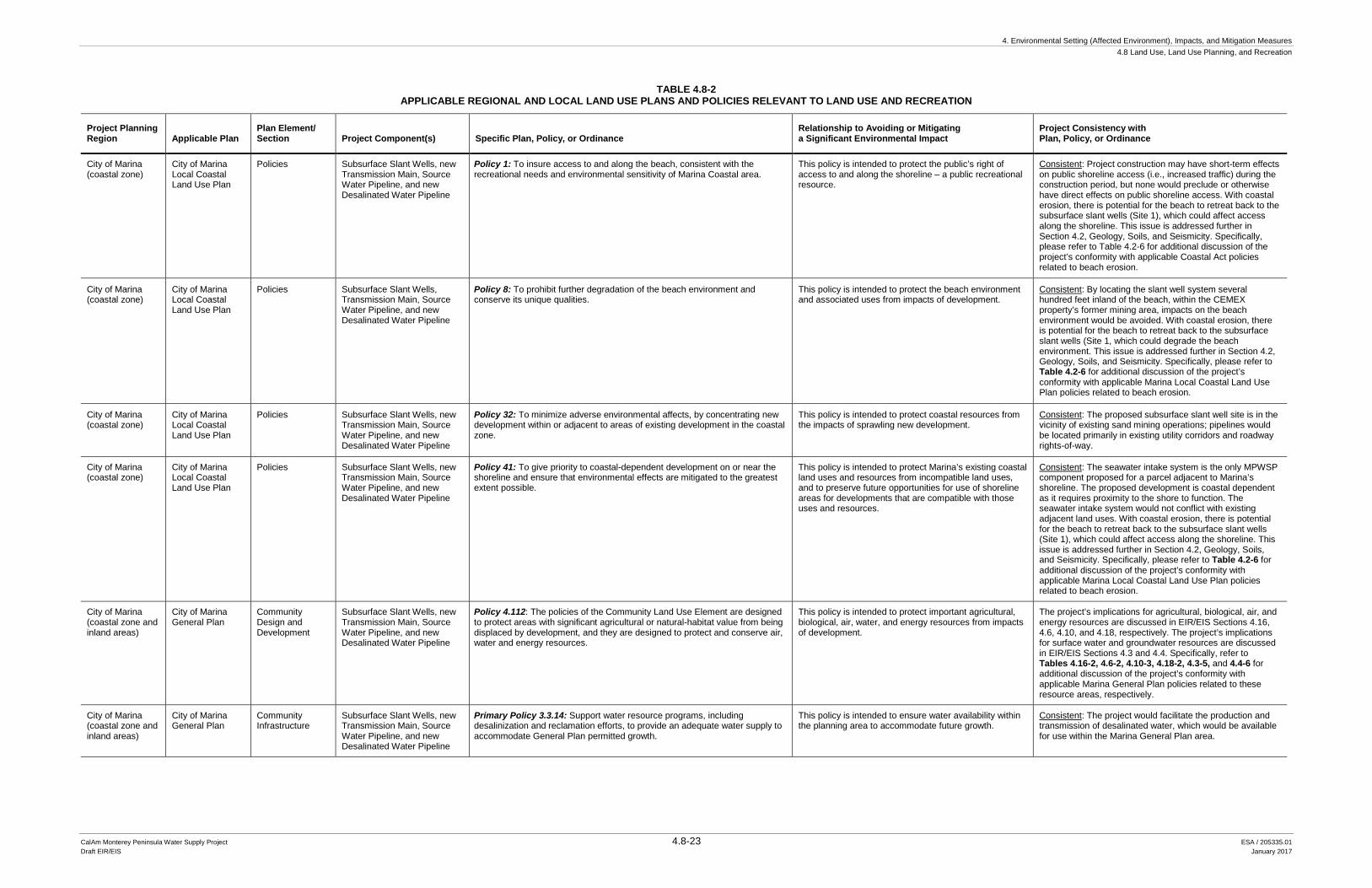
TABLE 4.8-2 APPLICABLE REGIONAL AND LOCAL LAND USE PLANS AND POLICIES RELEVANT TO LAND USE AND RECREATION
Project Planning Region Applicable Plan
Plan Element/ Section Project Component(s) Specific Plan, Policy, or Ordinance
Relationship to Avoiding or Mitigating a Significant Environmental Impact
Project Consistency with Plan, Policy, or Ordinance
City of Marina (coastal zone)
City of Marina Local Coastal Land Use Plan
Policies Subsurface Slant Wells, new Transmission Main, Source Water Pipeline, and new Desalinated Water Pipeline
Policy 1: To insure access to and along the beach, consistent with the recreational needs and environmental sensitivity of Marina Coastal area.
This policy is intended to protect the public’s right of access to and along the shoreline – a public recreational resource.
Consistent: Project construction may have short-term effects on public shoreline access (i.e., increased traffic) during the construction period, but none would preclude or otherwise have direct effects on public shoreline access. With coastal erosion, there is potential for the beach to retreat back to the subsurface slant wells (Site 1), which could affect access along the shoreline. This issue is addressed further in Section 4.2, Geology, Soils, and Seismicity. Specifically, please refer to Table 4.2-6 for additional discussion of the project’s conformity with applicable Coastal Act policies related to beach erosion.
City of Marina (coastal zone)
City of Marina Local Coastal Land Use Plan
Policies Subsurface Slant Wells, Transmission Main, Source Water Pipeline, and new Desalinated Water Pipeline
Policy 8: To prohibit further degradation of the beach environment and conserve its unique qualities.
This policy is intended to protect the beach environment and associated uses from impacts of development.
Consistent: By locating the slant well system several hundred feet inland of the beach, within the CEMEX property’s former mining area, impacts on the beach environment would be avoided. With coastal erosion, there is potential for the beach to retreat back to the subsurface slant wells (Site 1, which could degrade the beach environment. This issue is addressed further in Section 4.2, Geology, Soils, and Seismicity. Specifically, please refer to Table 4.2-6 for additional discussion of the project’s conformity with applicable Marina Local Coastal Land Use Plan policies related to beach erosion.
City of Marina (coastal zone)
City of Marina Local Coastal Land Use Plan
Policies Subsurface Slant Wells, new Transmission Main, Source Water Pipeline, and new Desalinated Water Pipeline
Policy 32: To minimize adverse environmental affects, by concentrating new development within or adjacent to areas of existing development in the coastal zone.
This policy is intended to protect coastal resources from the impacts of sprawling new development.
Consistent: The proposed subsurface slant well site is in the vicinity of existing sand mining operations; pipelines would be located primarily in existing utility corridors and roadway rights-of-way.
City of Marina (coastal zone)
City of Marina Local Coastal Land Use Plan
Policies Subsurface Slant Wells, new Transmission Main, Source Water Pipeline, and new Desalinated Water Pipeline
Policy 41: To give priority to coastal-dependent development on or near the shoreline and ensure that environmental effects are mitigated to the greatest extent possible.
This policy is intended to protect Marina’s existing coastal land uses and resources from incompatible land uses, and to preserve future opportunities for use of shoreline areas for developments that are compatible with those uses and resources.
Consistent: The seawater intake system is the only MPWSP component proposed for a parcel adjacent to Marina’s shoreline. The proposed development is coastal dependent as it requires proximity to the shore to function. The seawater intake system would not conflict with existing adjacent land uses. With coastal erosion, there is potential for the beach to retreat back to the subsurface slant wells (Site 1), which could affect access along the shoreline. This issue is addressed further in Section 4.2, Geology, Soils, and Seismicity. Specifically, please refer to Table 4.2-6 for additional discussion of the project’s conformity with applicable Marina Local Coastal Land Use Plan policies related to beach erosion.
City of Marina (coastal zone and inland areas)
City of Marina General Plan
Community Design and Development
Subsurface Slant Wells, new Transmission Main, Source Water Pipeline, and new Desalinated Water Pipeline
Policy 4.112: The policies of the Community Land Use Element are designed to protect areas with significant agricultural or natural-habitat value from being displaced by development, and they are designed to protect and conserve air, water and energy resources.
This policy is intended to protect important agricultural, biological, air, water, and energy resources from impacts of development.
The project’s implications for agricultural, biological, air, and energy resources are discussed in EIR/EIS Sections 4.16, 4.6, 4.10, and 4.18, respectively. The project’s implications for surface water and groundwater resources are discussed in EIR/EIS Sections 4.3 and 4.4. Specifically, refer to Tables 4.16-2, 4.6-2, 4.10-3, 4.18-2, 4.3-5, and 4.4-6 for additional discussion of the project’s conformity with applicable Marina General Plan policies related to these resource areas, respectively.
City of Marina (coastal zone and inland areas)
City of Marina General Plan
Community Infrastructure
Subsurface Slant Wells, new Transmission Main, Source Water Pipeline, and new Desalinated Water Pipeline
Primary Policy 3.3.14: Support water resource programs, including desalinization and reclamation efforts, to provide an adequate water supply to accommodate General Plan permitted growth.
This policy is intended to ensure water availability within the planning area to accommodate future growth.
Consistent: The project would facilitate the production and transmission of desalinated water, which would be available for use within the Marina General Plan area.
4. Environmental Setting (Affected Environment), Impacts, and Mitigation Measures 4.8 Land Use, Land Use Planning, and Recreation
CalAm Monterey Peninsula Water Supply Project 4.8-24 ESA / 205335.01 Draft EIR/EIS January 2017
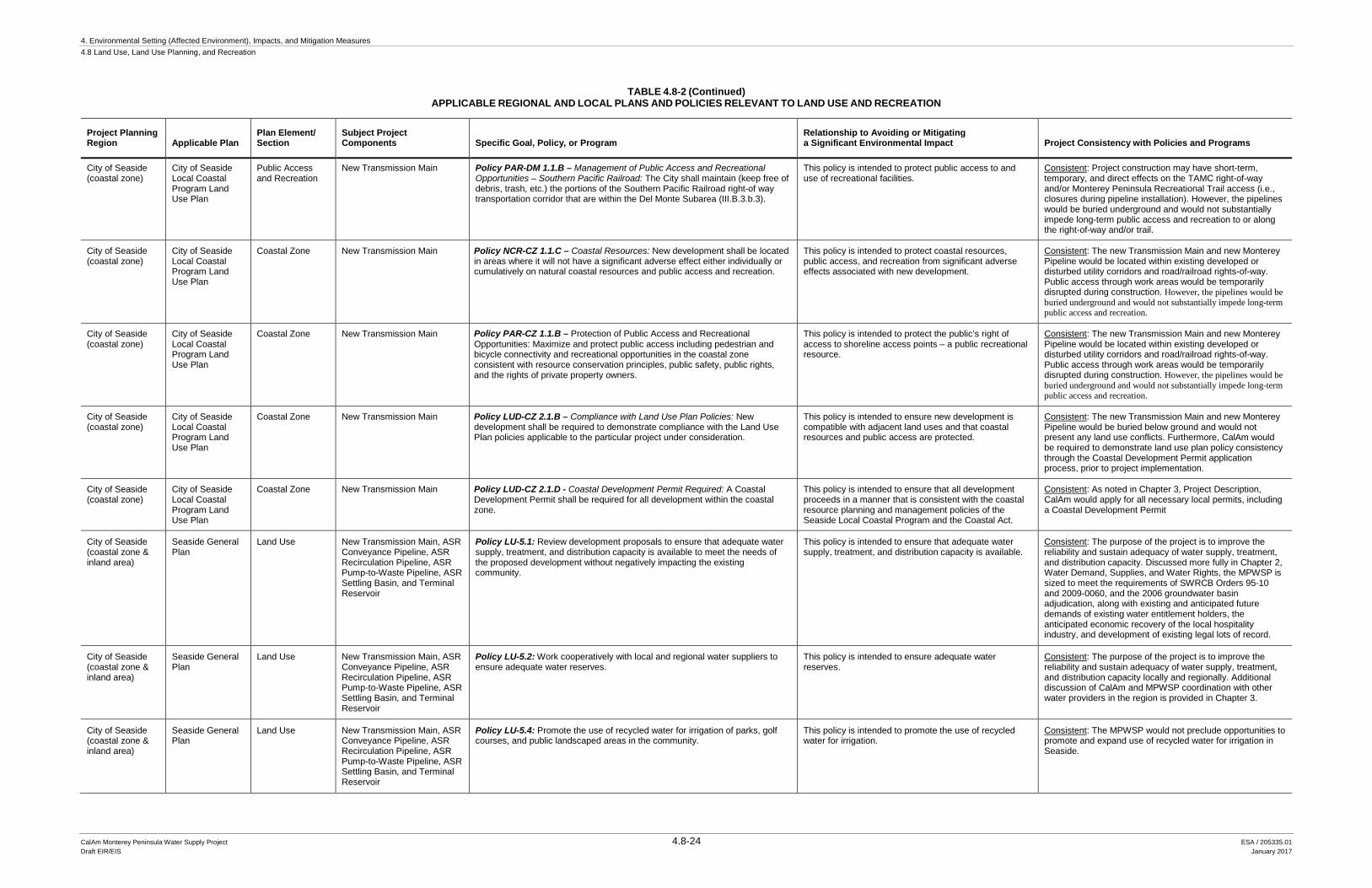
TABLE 4.8-2 (Continued) APPLICABLE REGIONAL AND LOCAL PLANS AND POLICIES RELEVANT TO LAND USE AND RECREATION
Project Planning Region Applicable Plan
Plan Element/ Section
Subject Project Components Specific Goal, Policy, or Program
Relationship to Avoiding or Mitigating a Significant Environmental Impact Project Consistency with Policies and Programs
City of Seaside (coastal zone)
City of Seaside Local Coastal Program Land Use Plan
Public Access and Recreation
New Transmission Main Policy PAR-DM 1.1.B – Management of Public Access and Recreational Opportunities – Southern Pacific Railroad: The City shall maintain (keep free of debris, trash, etc.) the portions of the Southern Pacific Railroad right-of way transportation corridor that are within the Del Monte Subarea (III.B.3.b.3).
This policy is intended to protect public access to and use of recreational facilities.
Consistent: Project construction may have short-term, temporary, and direct effects on the TAMC right-of-way and/or Monterey Peninsula Recreational Trail access (i.e., closures during pipeline installation). However, the pipelines would be buried underground and would not substantially impede long-term public access and recreation to or along the right-of-way and/or trail.
City of Seaside (coastal zone)
City of Seaside Local Coastal Program Land Use Plan
Coastal Zone New Transmission Main Policy NCR-CZ 1.1.C – Coastal Resources: New development shall be located in areas where it will not have a significant adverse effect either individually or cumulatively on natural coastal resources and public access and recreation.
This policy is intended to protect coastal resources, public access, and recreation from significant adverse effects associated with new development.
Consistent: The new Transmission Main and new Monterey Pipeline would be located within existing developed or disturbed utility corridors and road/railroad rights-of-way. Public access through work areas would be temporarily disrupted during construction. However, the pipelines would be buried underground and would not substantially impede long-term public access and recreation.
City of Seaside (coastal zone)
City of Seaside Local Coastal Program Land Use Plan
Coastal Zone New Transmission Main Policy PAR-CZ 1.1.B – Protection of Public Access and Recreational Opportunities: Maximize and protect public access including pedestrian and bicycle connectivity and recreational opportunities in the coastal zone consistent with resource conservation principles, public safety, public rights, and the rights of private property owners.
This policy is intended to protect the public’s right of access to shoreline access points – a public recreational resource.
Consistent: The new Transmission Main and new Monterey Pipeline would be located within existing developed or disturbed utility corridors and road/railroad rights-of-way. Public access through work areas would be temporarily disrupted during construction. However, the pipelines would be buried underground and would not substantially impede long-term public access and recreation.
City of Seaside (coastal zone)
City of Seaside Local Coastal Program Land Use Plan
Coastal Zone New Transmission Main Policy LUD-CZ 2.1.B – Compliance with Land Use Plan Policies: New development shall be required to demonstrate compliance with the Land Use Plan policies applicable to the particular project under consideration.
This policy is intended to ensure new development is compatible with adjacent land uses and that coastal resources and public access are protected.
Consistent: The new Transmission Main and new Monterey Pipeline would be buried below ground and would not present any land use conflicts. Furthermore, CalAm would be required to demonstrate land use plan policy consistency through the Coastal Development Permit application process, prior to project implementation.
City of Seaside (coastal zone)
City of Seaside Local Coastal Program Land Use Plan
Coastal Zone New Transmission Main Policy LUD-CZ 2.1.D - Coastal Development Permit Required: A Coastal Development Permit shall be required for all development within the coastal zone.
This policy is intended to ensure that all development proceeds in a manner that is consistent with the coastal resource planning and management policies of the Seaside Local Coastal Program and the Coastal Act.
Consistent: As noted in Chapter 3, Project Description, CalAm would apply for all necessary local permits, including a Coastal Development Permit
City of Seaside (coastal zone & inland area)
Seaside General Plan
Land Use New Transmission Main, ASR Conveyance Pipeline, ASR Recirculation Pipeline, ASR Pump-to-Waste Pipeline, ASR Settling Basin, and Terminal Reservoir
Policy LU-5.1: Review development proposals to ensure that adequate water supply, treatment, and distribution capacity is available to meet the needs of the proposed development without negatively impacting the existing community.
This policy is intended to ensure that adequate water supply, treatment, and distribution capacity is available.
Consistent: The purpose of the project is to improve the reliability and sustain adequacy of water supply, treatment, and distribution capacity. Discussed more fully in Chapter 2, Water Demand, Supplies, and Water Rights, the MPWSP is sized to meet the requirements of SWRCB Orders 95-10 and 2009-0060, and the 2006 groundwater basin adjudication, along with existing and anticipated future demands of existing water entitlement holders, the anticipated economic recovery of the local hospitality industry, and development of existing legal lots of record.
City of Seaside (coastal zone & inland area)
Seaside General Plan
Land Use New Transmission Main, ASR Conveyance Pipeline, ASR Recirculation Pipeline, ASR Pump-to-Waste Pipeline, ASR Settling Basin, and Terminal Reservoir
Policy LU-5.2: Work cooperatively with local and regional water suppliers to ensure adequate water reserves.
This policy is intended to ensure adequate water reserves.
Consistent: The purpose of the project is to improve the reliability and sustain adequacy of water supply, treatment, and distribution capacity locally and regionally. Additional discussion of CalAm and MPWSP coordination with other water providers in the region is provided in Chapter 3.
City of Seaside (coastal zone & inland area)
Seaside General Plan
Land Use New Transmission Main, ASR Conveyance Pipeline, ASR Recirculation Pipeline, ASR Pump-to-Waste Pipeline, ASR Settling Basin, and Terminal Reservoir
Policy LU-5.4: Promote the use of recycled water for irrigation of parks, golf courses, and public landscaped areas in the community.
This policy is intended to promote the use of recycled water for irrigation.
Consistent: The MPWSP would not preclude opportunities to promote and expand use of recycled water for irrigation in Seaside.
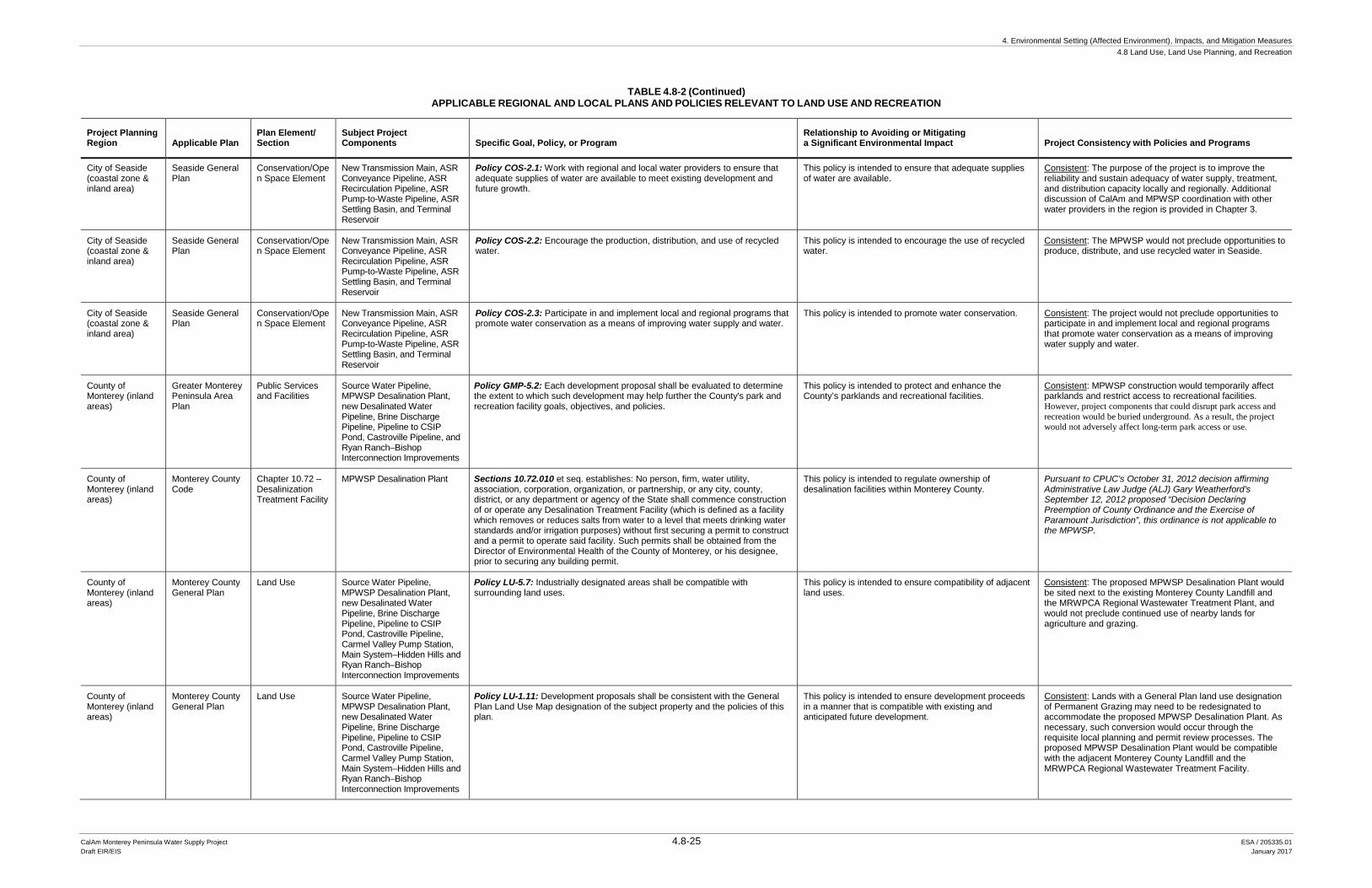
4. Environmental Setting (Affected Environment), Impacts, and Mitigation Measures 4.8 Land Use, Land Use Planning, and Recreation
CalAm Monterey Peninsula Water Supply Project 4.8-25 ESA / 205335.01 Draft EIR/EIS January 2017
TABLE 4.8-2 (Continued) APPLICABLE REGIONAL AND LOCAL PLANS AND POLICIES RELEVANT TO LAND USE AND RECREATION
Project Planning Region Applicable Plan
Plan Element/ Section
Subject Project Components Specific Goal, Policy, or Program
Relationship to Avoiding or Mitigating a Significant Environmental Impact Project Consistency with Policies and Programs
City of Seaside (coastal zone & inland area)
Seaside General Plan
Conservation/Open Space Element
New Transmission Main, ASR Conveyance Pipeline, ASR Recirculation Pipeline, ASR Pump-to-Waste Pipeline, ASR Settling Basin, and Terminal Reservoir
Policy COS-2.1: Work with regional and local water providers to ensure that adequate supplies of water are available to meet existing development and future growth.
This policy is intended to ensure that adequate supplies of water are available.
Consistent: The purpose of the project is to improve the reliability and sustain adequacy of water supply, treatment, and distribution capacity locally and regionally. Additional discussion of CalAm and MPWSP coordination with other water providers in the region is provided in Chapter 3.
City of Seaside (coastal zone & inland area)
Seaside General Plan
Conservation/Open Space Element
New Transmission Main, ASR Conveyance Pipeline, ASR Recirculation Pipeline, ASR Pump-to-Waste Pipeline, ASR Settling Basin, and Terminal Reservoir
Policy COS-2.2: Encourage the production, distribution, and use of recycled water.
This policy is intended to encourage the use of recycled water.
Consistent: The MPWSP would not preclude opportunities to produce, distribute, and use recycled water in Seaside.
City of Seaside (coastal zone & inland area)
Seaside General Plan
Conservation/Open Space Element
New Transmission Main, ASR Conveyance Pipeline, ASR Recirculation Pipeline, ASR Pump-to-Waste Pipeline, ASR Settling Basin, and Terminal Reservoir
Policy COS-2.3: Participate in and implement local and regional programs that promote water conservation as a means of improving water supply and water.
This policy is intended to promote water conservation. Consistent: The project would not preclude opportunities to participate in and implement local and regional programs that promote water conservation as a means of improving water supply and water.
County of Monterey (inland areas)
Greater Monterey Peninsula Area Plan
Public Services and Facilities
Source Water Pipeline, MPWSP Desalination Plant, new Desalinated Water Pipeline, Brine Discharge Pipeline, Pipeline to CSIP Pond, Castroville Pipeline, and Ryan Ranch–Bishop Interconnection Improvements
Policy GMP-5.2: Each development proposal shall be evaluated to determine the extent to which such development may help further the County's park and recreation facility goals, objectives, and policies.
This policy is intended to protect and enhance the County’s parklands and recreational facilities.
Consistent: MPWSP construction would temporarily affect parklands and restrict access to recreational facilities. However, project components that could disrupt park access and recreation would be buried underground. As a result, the project would not adversely affect long-term park access or use.
County of Monterey (inland areas)
Monterey County Code
Chapter 10.72 – Desalinization Treatment Facility
MPWSP Desalination Plant Sections 10.72.010 et seq. establishes: No person, firm, water utility, association, corporation, organization, or partnership, or any city, county, district, or any department or agency of the State shall commence construction of or operate any Desalination Treatment Facility (which is defined as a facility which removes or reduces salts from water to a level that meets drinking water standards and/or irrigation purposes) without first securing a permit to construct and a permit to operate said facility. Such permits shall be obtained from the Director of Environmental Health of the County of Monterey, or his designee, prior to securing any building permit.
This policy is intended to regulate ownership of desalination facilities within Monterey County.
Pursuant to CPUC’s October 31, 2012 decision affirming Administrative Law Judge (ALJ) Gary Weatherford’s September 12, 2012 proposed “Decision Declaring Preemption of County Ordinance and the Exercise of Paramount Jurisdiction”, this ordinance is not applicable to the MPWSP.
County of Monterey (inland areas)
Monterey County General Plan
Land Use Source Water Pipeline, MPWSP Desalination Plant, new Desalinated Water Pipeline, Brine Discharge Pipeline, Pipeline to CSIP Pond, Castroville Pipeline, Carmel Valley Pump Station, Main System–Hidden Hills and Ryan Ranch–Bishop Interconnection Improvements
Policy LU-5.7: Industrially designated areas shall be compatible with surrounding land uses.
This policy is intended to ensure compatibility of adjacent land uses.
Consistent: The proposed MPWSP Desalination Plant would be sited next to the existing Monterey County Landfill and the MRWPCA Regional Wastewater Treatment Plant, and would not preclude continued use of nearby lands for agriculture and grazing.
County of Monterey (inland areas)
Monterey County General Plan
Land Use Source Water Pipeline, MPWSP Desalination Plant, new Desalinated Water Pipeline, Brine Discharge Pipeline, Pipeline to CSIP Pond, Castroville Pipeline, Carmel Valley Pump Station, Main System–Hidden Hills and Ryan Ranch–Bishop Interconnection Improvements
Policy LU-1.11: Development proposals shall be consistent with the General Plan Land Use Map designation of the subject property and the policies of this plan.
This policy is intended to ensure development proceeds in a manner that is compatible with existing and anticipated future development.
Consistent: Lands with a General Plan land use designation of Permanent Grazing may need to be redesignated to accommodate the proposed MPWSP Desalination Plant. As necessary, such conversion would occur through the requisite local planning and permit review processes. The proposed MPWSP Desalination Plant would be compatible with the adjacent Monterey County Landfill and the MRWPCA Regional Wastewater Treatment Facility.
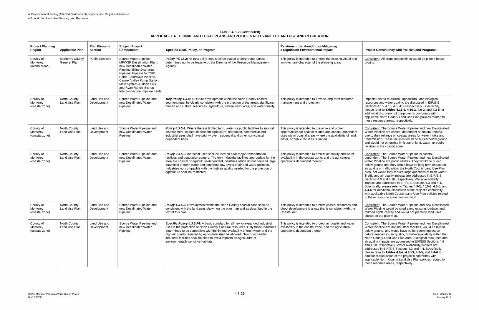
4. Environmental Setting (Affected Environment), Impacts, and Mitigation Measures 4.8 Land Use, Land Use Planning, and Recreation
CalAm Monterey Peninsula Water Supply Project 4.8-26 ESA / 205335.01 Draft EIR/EIS January 2017
TABLE 4.8-2 (Continued) APPLICABLE REGIONAL AND LOCAL PLANS AND POLICIES RELEVANT TO LAND USE AND RECREATION
Project Planning Region Applicable Plan
Plan Element/ Section
Subject Project Components Specific Goal, Policy, or Program
Relationship to Avoiding or Mitigating a Significant Environmental Impact Project Consistency with Policies and Programs
County of Monterey (inland areas)
Monterey County General Plan
Public Services Source Water Pipeline, MPWSP Desalination Plant, new Desalinated Water Pipeline, Brine Discharge Pipeline, Pipeline to CSIP Pond, Castroville Pipeline, Carmel Valley Pump Station, Main System–Hidden Hills and Ryan Ranch–Bishop Interconnection Improvements
Policy PS-13.2: All new utility lines shall be placed underground, unless determined not to be feasible by the Director of the Resource Management Agency.
This policy is intended to protect the existing visual and architectural character of the planning area.
Consistent: All proposed pipelines would be placed below ground.
County of Monterey (coastal zone)
North County Land Use Plan
Land Use and Development
Source Water Pipeline and new Desalinated Water Pipeline
Key Policy 4.3.4: All future development within the North County coastal segment must be clearly consistent with the protection of the area’s significant human and cultural resources, agriculture, natural resources, and water quality.
This policy is intended to provide long-term resource management and protection.
Impacts related to cultural, agricultural, and biological resources and water quality, are discussed in EIR/EIS Sections 4.15, 4.16, 4.6, 4.3, respectively. Specifically, please refer to Tables 4.15-6, 4.16-2, 4.6-2, and 4.3-5 for additional discussion of the project’s conformity with applicable North County Land Use Plan policies related to these resource areas, respectively.
County of Monterey (coastal zone)
North County Land Use Plan
Land Use and Development
Source Water Pipeline and new Desalinated Water Pipeline
Policy 4.3.5.4: Where there is limited land, water, or public facilities to support development, coastal dependent agriculture, recreation, commercial and industrial uses shall have priority over residential and other non-coastal dependent uses.
This policy is intended to preserve and protect opportunities for coastal-related and coastal-dependent uses within coastal areas where the availability of land, water, or public facilities is limited.
Consistent: The Source Water Pipeline and new Desalinated Water Pipeline are coastal-dependent or coastal-related, due to their reliance on coastal areas for water intake and transmission. These facilities would be buried below ground and would not otherwise limit use of land, water, or public facilities in the coastal zone.
County of Monterey (coastal zone)
North County Land Use Plan
Land Use and Development
Source Water Pipeline and new Desalinated Water Pipeline
Policy 2.3.5.6: Industrial uses shall be located near major transportation facilities and population centers. The only industrial facilities appropriate for the area are coastal or agriculture-dependent industries which do not demand large quantities of fresh water and contribute low levels of air and water pollution. Industries not compatible with the high air quality needed for the protection of agriculture shall be restricted.
This policy is intended to protect air quality and water availability in the coastal zone, and the agricultural operations dependent thereon.
Consistent: The Source Water Pipeline is coastal dependent. The Source Water Pipeline and new Desalinated Water Pipeline are public utilities. They would be buried below ground and they would have no long-term impact on air quality or traffic within the North County Land Use Plan area, nor would they require large quantities of fresh water. Traffic and air quality impacts are addressed in EIR/EIS Sections 4.9 and 4.10, respectively. Water availability impacts are addressed in EIR/EIS Sections 4.3 and 4.4. Specifically, please refer to Tables 4.9-2, 4.10-3, 4.3-5, and 4.4-6 for additional discussion of the project’s conformity with applicable North County Land Use Plan policies related to these resource areas, respectively.
County of Monterey (coastal zone)
North County Land Use Plan
Land Use and Development
Source Water Pipeline and new Desalinated Water Pipeline
Policy 4.3.5.8: Development within the North County coastal zone shall be consistent with the land uses shown on the plan map and as described in the text of this plan.
This policy is intended to protect coastal resources and direct development is a way that is consistent with the Coastal Act.
Consistent: The Source Water Pipeline and new Desalinated Water Pipeline would be sited along existing roadway and railroad rights-of-way and would not preclude land uses shown on the plan map.
County of Monterey (coastal zone)
North County Land Use Plan
Land Use and Development
Source Water Pipeline and new Desalinated Water Pipeline
Specific Policy 4.3.6 F4: A basic standard for all new or expanded industrial uses is the protection of North County’s natural resources. Only those industries determined to be compatible with the limited availability of freshwater and the high air quality required by agriculture shall be allowed. New or expanded industrial facilities shall be sited to avoid impacts on agriculture of environmentally sensitive habitats.
This policy is intended to protect air quality and water availability in the coastal zone, and the agricultural operations dependent thereon.
Consistent: The Source Water Pipeline and new Desalinated Water Pipeline are not industrial facilities, would be buried below ground, and would have no long-term impact on natural resources, air quality, or water availability within the North County Land Use Plan area. Biological resources and air quality impacts are addressed in EIR/EIS Sections 4.6 and 4.10, respectively. Water availability impacts are addressed in EIR/EIS Sections 4.3 and 4.4. Specifically, please refer to Tables 4.6-2, 4.10-3, 4.3-5, and 4.4-6 for additional discussion of the project’s conformity with applicable North County Land Use Plan policies related to these resource areas, respectively.
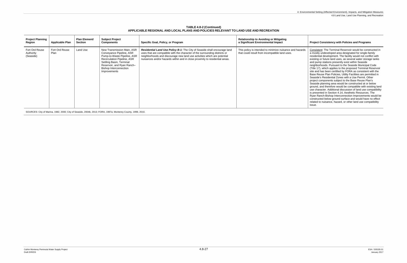
4. Environmental Setting (Affected Environment), Impacts, and Mitigation Measures 4.8 Land Use, Land Use Planning, and Recreation
CalAm Monterey Peninsula Water Supply Project 4.8-27 ESA / 205335.01 Draft EIR/EIS January 2017
TABLE 4.8-2 (Continued) APPLICABLE REGIONAL AND LOCAL PLANS AND POLICIES RELEVANT TO LAND USE AND RECREATION
Project Planning Region Applicable Plan
Plan Element/ Section
Subject Project Components Specific Goal, Policy, or Program
Relationship to Avoiding or Mitigating a Significant Environmental Impact Project Consistency with Policies and Programs
Fort Ord Reuse Authority (Seaside)
Fort Ord Reuse Plan
Land Use New Transmission Main, ASR Conveyance Pipeline, ASR Pump-to-Waste Pipeline, ASR Recirculation Pipeline, ASR Settling Basin, Terminal Reservoir, and Ryan Ranch–Bishop Interconnection Improvements
Residential Land Use Policy B-1: The City of Seaside shall encourage land uses that are compatible with the character of the surrounding districts or neighborhoods and discourage new land use activities which are potential nuisances and/or hazards within and in close proximity to residential areas.
This policy is intended to minimize nuisance and hazards that could result from incompatible land uses.
Consistent: The Terminal Reservoir would be constructed in a mostly undeveloped area designated for single-family residential development. The facility would not conflict with existing or future land uses, as several water storage tanks and pump stations presently exist within Seaside neighborhoods. Pursuant to the Seaside Municipal Code (Title 17), which applies to the proposed Terminal Reservoir site and has been certified by FORA as consistent with the Base Reuse Plan Policies, Utility Facilities are permitted in Seaside’s Residential Zones with a Use Permit. Other project components subject to the Base Reuse Plan’s Seaside planning area would be constructed at or below ground, and therefore would be compatible with existing land use character. Additional discussion of land use compatibility is presented in Section 4.14, Aesthetic Resources. The Ryan Ranch-Bishop Interconnection Improvements would be constructed below ground surface and would have no effect related to nuisance, hazard, or other land use compatibility issue.
SOURCES: City of Marina, 1982, 2000; City of Seaside, 2004b, 2013; FORA, 1997a; Monterey County, 1999, 2010.
4. Environmental Setting (Affected Environment), Impacts, and Mitigation Measures 4.8 Land Use, Land Use Planning, and Recreation
CalAm Monterey Peninsula Water Supply Project 4.8-28 ESA / 205335.01 Draft EIR/EIS January 2017
This page intentionally left blank
4. Environmental Setting (Affected Environment), Impacts, and Mitigation Measures 4.8 Land Use, Land Use Planning, and Recreation
CalAm Monterey Peninsula Water Supply Project 4.8-29 ESA / 205335.01 Draft EIR/EIS January 2017
Determinations of consistency with these criteria are reserved for the governing body with jurisdiction. However, for purposes of environmental review and public disclosure, this EIR/EIS provides a preliminary assessment of project consistency with applicable local land use policies and regulations. Analyses of consistency in this EIR/EIS are presented in each Chapter 4 environmental topic’s Regulatory Framework subsection (e.g., Section 4.2 of this Land Use, Land Use Planning, and Recreation section) and appear in tables entitled “Regional and Local Land Use Policies Relevant to [subject impact topic]”. As noted in the preceding subsection, where potential conflicts are identified, the reader is referred to the respective environmental topic’s subsection entitled Direct and Indirect Effects of the Project where the potential conflict is further evaluated.
In all but one instance related to specific MPWSP components’ compatibility with established land use policies related to biological resources (i.e., Impacts 4.6-4), potential land use policy and regulation conflicts are resolvable with the implementation of recommended mitigation. And in those instances in which potential conflicts could remain after mitigation is implemented, the proposed use would not be fundamentally inconsistent with intent of the respective site’s established land use and zoning classification, nor would the effects substantially conflict with the public health, safety, and welfare criteria underlying most Use Permit decisions. Therefore, based upon the analyses presented herein, the local body overseeing land use and development decisions should be able to make the consistency findings necessary for Use Permit and/or CDP issuance.
Subsurface Slant Wells
The subsurface slant wells are proposed in a retired portion of the CEMEX sand mining operation in northern Marina. This area is identified on the land use plan as Habitat Reserve and Other Open Spaces, and zoned for Coastal Conservation and Development (CD) uses. According to the City of Marina General Plan, lands designated as Habitat Reserve and Other Open Spaces are “intended for permanent retention in open space to protect significant plants and wildlife inhabiting these areas” (City of Marina, 2000). The City of Marina General Plan recognizes the presence of the CEMEX sand mining facility and provides for the continuation, modification, and expansion of sand mining activities on the property in accordance with the provisions of the Local Coastal Program and Reclamation Plan (City of Marina, 2000). The City of Marina Local Coastal Program and zoning regulations provide for conditional approval of coastal-dependent industrial land uses, including, but not limited to surf zone and offshore sand extraction and dune mining, within the CD district (City of Marina, 1982; 2009). CalAm will need to obtain a CDP from the City of Marina for implementation of the subsurface slant wells. Per the above discussion of project consistency with applicable land use policies and regulations, the City of Marina should be able to make findings in support of CDP issuance for the subsurface slant wells. With the requisite CDP, the proposed subsurface slant wells would not conflict with land use plan and zoning designations.
MPWSP Desalination Plant
The MPWSP Desalination Plant would be located in unincorporated Monterey County. The site is identified as Permanent Grazing (PG) in both the Monterey County General Plan Land Use Map and County Zoning Map. Per the Monterey County General Plan, the PG designation allows a
4. Environmental Setting (Affected Environment), Impacts, and Mitigation Measures 4.8 Land Use, Land Use Planning, and Recreation
CalAm Monterey Peninsula Water Supply Project 4.8-30 ESA / 205335.01 Draft EIR/EIS January 2017
range of uses that conserve and enhance productive grazing lands. According to the Monterey County General Plan, greenhouse operations notwithstanding, building coverage on PG lands shall be limited to 5 percent of the property (Monterey County, 2010). The Monterey County Zoning Ordinance provides for public and quasi-public uses, such as public utilities, within PG districts provided applicants obtain a Use Permit (Monterey County, 1997). The minimum building site is 40 acres. Per the zoning regulations, projects such as the MPWSP involving building coverage in excess of the 5 percent limit would require a variance. Chapter 21.72 establishes and outlines the process for obtaining a variance. The variance notwithstanding, per the above discussion of project consistency with applicable land use policies and regulations, the County of Monterey should be able to make findings in support of Use Permit issuance for the MPWSP Desalination Plant. Through adherence to the variance process, and with the Zoning Administrator’s finding that the criteria for a variance have been met, the MPWSP Desalination Plant would not conflict with land use plan and zoning designations.
Pipelines North of Reservation Road
Conveyance facilities north of Reservation Road would include the Source Water Pipeline and optional alignment, new Desalinated Water Pipeline and optional alignment, Castroville Pipeline and optional alignments, Brine Discharge Pipeline, and Pipeline to CSIP Pond. These facilities would be constructed within portions of Marina and unincorporated Monterey County. Pipeline alignments would generally follow the TAMC right-of-way, Monterey Peninsula Recreational Trail, and existing road rights-of-way. Land uses along these pipeline alignments are identified on the land use plans as Habitat Reserve and Other Open Space Preserve (coastal Marina); Agricultural Preservation and Light Industrial (coastal Monterey County); and Mixed Use, Low Density Residential, Farmland, and Permanent Grazing (inland Monterey County). Zoning designations for these lands include Coastal Conservation and Development (coastal Marina); Resource Conservation, Coastal Agricultural Preservation, and Light Industrial (coastal Monterey County); and Permanent Grazing, Farmland, Mixed Use, Low Density Residential, and Public/Quasi-Public uses (inland Monterey County). Marina (Section 17.06.020.D) and Monterey County (Sections 20.64.160.C and 21.64.160.C) zoning regulations allow public utility distribution and transmission facilities in all zone districts. Marina and Monterey County require project applicants to obtain one or more approvals (such as a Use Permit or a CDP, and/or planning commission review) prior to construction of any portion of the pipelines. Per the above discussion of project consistency with applicable land use policies and regulations, the City of Marina and Monterey County should be able to make findings in support of Use Permit and/or CDP authorization, as applicable, for MPWSP pipelines north of Reservation Road. With the requisite Use Permit and/or CDP, as applicable, the proposed pipelines would not conflict with underlying land use plan and zoning designations.
ASR-5 and ASR-6 Wells
The proposed ASR-5 and ASR-6 Wells would be constructed along the east side of General Jim Moore Boulevard in Seaside, entirely on federally-owned land within the former Fort Ord military base. As noted previously, land use decisions in this area are under the jurisdiction of the U.S. Army and are guided by the Real Property Master Plan. The U.S. Army analyzed the
4. Environmental Setting (Affected Environment), Impacts, and Mitigation Measures 4.8 Land Use, Land Use Planning, and Recreation
CalAm Monterey Peninsula Water Supply Project 4.8-31 ESA / 205335.01 Draft EIR/EIS January 2017
potential land use effects of the proposed ASR-5 and ASR-6 Wells in the Final Environmental Assessment and Finding of No Significant Impact, Monterey Bay Regional Water Project – Aquifer Storage and Recovery. The Environmental Assessment concluded the proposed ASR-5 and ASR-6 Wells would have no impact with respect to conflict with any applicable land use plans, policies, or regulations (RBF Consulting, 2010). As these components would be constructed entirely within lands under federal jurisdiction and not subject to local land use regulation, no determination regarding potential conflicts with established land use and zoning designations is provided.
Pipelines South of Reservation Road
Conveyance facilities south of Reservation Road would include the new Transmission Main and optional alignment, ASR pipelines, Main System–Hidden Hills Interconnection Improvements, and Ryan Ranch–Bishop Interconnection Improvements. These components would cross portions of the cities of Marina, Seaside, Monterey, and unincorporated Monterey County. The proposed pipeline alignments would generally follow the Monterey Peninsula Recreational Trail, TAMC right-of-way, and other road rights-of-way. Land use plan designations for property within or adjacent to these pipeline alignments range from Parks and Open Space Preserve, to Military and Industrial. Zoning along the pipeline alignments also spans a similarly broad range of designations. As noted for conveyance pipelines north of Reservation Road, Marina and Monterey County zoning regulations allow public utilities in all zone districts with a Use Permit, Coastal Development Permit, and/or planning commission review. Zoning regulations for the cities of Seaside and Monterey also allow major public utilities in all such districts with a Use Permit. Per the above discussion of project consistency with applicable land use policies and regulations, the cities of Seaside and Monterey should be able to make findings in support of Use Permit authorization, as applicable, for MPWSP pipelines south of Reservation Road. With the requisite Use Permit, as applicable, the proposed pipelines would not conflict with underlying land use plan and zoning designations.
Terminal Reservoir
The proposed Terminal Reservoir would be located in Seaside, east of General Jim Moore Boulevard, in the former Fort Ord military base. The Terminal Reservoir site has a land use plan designation of Low Density Residential and is zoned for Single Family Residential (RS-8) uses. The Seaside Zoning Code (Section 17.22.030) allows utility facilities in Residential districts with a Use Permit. The Seaside Zoning Code considers water supply infrastructure to be utility facilities. Per the above discussion of project consistency with applicable land use policies and regulations, the City of Seaside should be able to make findings in support of Use Permit authorization. With the requisite Use Permit, the proposed Terminal Reservoir would not conflict with the site’s land use and zoning designations.
Carmel Valley Pump Station
The Carmel Valley Pump Station would be constructed on lands in unincorporated Monterey County. The proposed site, which is located approximately 240 feet south of Carmel Valley Road (west of Rancho San Carlos Road), has land use plan and zoning designations Residential – Low
4. Environmental Setting (Affected Environment), Impacts, and Mitigation Measures 4.8 Land Use, Land Use Planning, and Recreation
CalAm Monterey Peninsula Water Supply Project 4.8-32 ESA / 205335.01 Draft EIR/EIS January 2017
Density (LDR/2.5-D-S-RAZ). The Carmel Valley Pump Station would be consistent with the Residential – Low Density land use classifications. The County of Monterey Zoning Ordinance for Inland Areas (Section 21.14.050.B) allows public and quasi-public uses, including public utility facilities, in the LDR zone with a Use Permit. Public utility facilities include facilities for the “production, storage, transmission, distribution, and recovery of water…” (21.06.910). Per the above discussion of project consistency with applicable land use policies and regulations, Monterey County should be able to make findings in support of Use Permit authorization. With the requisite Use Permit, the proposed pump station would not conflict with underlying land use plan and zoning designations.
4.8.2.4 Special Districts
Transportation Agency for Monterey County (TAMC)
Portions of the new Desalinated Water Pipeline, new Transmission Main, and Castroville Pipelines, and their respective optional alignments, would be located generally within the TAMC right-of-way. For these segments an easement or encroachment permit may be required from TAMC (refer to Chapter 3, Project Description). TAMC has identified potential future plans to utilize its existing right-of-way to extend commuter service in Salinas and passenger service to and from the Monterey Peninsula. CalAm and the MWPSP design engineer are coordinating with TAMC to ensure the proposed facilities do not conflict with potential future TAMC plans for use of the right-of-way.
Monterey Peninsula Water Management District
The Monterey Peninsula Water Management District (MPWMD) manages the production of surface water supplies from the Carmel River and groundwater pumped from municipal and private wells in Carmel Valley and the Seaside coastal area. The MPWMD’s jurisdictional boundary generally corresponds to CalAm’s Monterey District service area, with the exception of an area north and east of Seaside and Sand City that is within the MPWMD’s jurisdiction but is served by the Marina Coast Water District. MPWMD was created by the California Legislature in 1977 as a special district and approved by local voters in 1978. MPWMD regulates water allocation, delivery, and use within its jurisdictional boundary. The location of the facility or water source, quantity of water, and delivery determine the type of permit required from MPWMD and conditions of approval. Even if the proposed treatment facility is not located within MPWMD jurisdiction, the delivery and use of the desalinated water produced by the project (“product water”) within the jurisdiction is still subject to MPWMD regulations. That is, if any of the proposed facility components are within the MPWMD’s jurisdictional boundary, CalAm must apply for a Water System Expansion Permit (MPWMD, 2001). Portions of the proposed project would be within the MPWMD jurisdiction; therefore, CalAm would be required to obtain a Water System Expansion Permit for project operation.
4. Environmental Setting (Affected Environment), Impacts, and Mitigation Measures 4.8 Land Use, Land Use Planning, and Recreation
CalAm Monterey Peninsula Water Supply Project 4.8-33 ESA / 205335.01 Draft EIR/EIS January 2017
4.8.3 Evaluation Criteria Implementation of the proposed project would have a significant impact related to land use, land use planning, and recreational resources if it would:
• Physically divide an established community;
• Conflict with any applicable land use plan, policy, or regulation of an agency with jurisdiction over the project (including, but not limited to the general plan, specific plan, local coastal program, or zoning ordinance) adopted for the purpose of avoiding or mitigating an environmental effect;
• Conflict with any applicable habitat conservation plan or natural community conservation plan;
• Increase the use of existing neighborhood and regional parks or other recreational facilities such that substantial physical deterioration of the facility would occur or be accelerated; or
• Include recreational facilities or require the construction or expansion of recreational facilities which might have an adverse physical effect on the environment.
• Disrupt or preclude public access to or along the coast.
4.8.4 Approach to Analysis The analysis considers the proposed project’s potential to conflict with applicable plans, policies, and regulations governing land use decisions. This analysis addresses the potential for temporary impacts on land use and recreation during construction, as well as long-term impacts resulting from project siting and operations. Where the project would result in a significant impact or conflict with a regulatory requirement, mitigation measures are recommended to reduce the impact significance and/or resolve or minimize the potential regulatory conflict.
4.8.5 Direct and Indirect Effects of the Proposed Project Based on the nature of the proposed project, the following significance criteria are not addressed further in the section:
Physically divide an established community. All of the linear facilities that are proposed as part of the project (e.g., pipelines) would be located underground, and the overlying areas would be restored after construction. Aboveground structures that would be constructed include the subsurface slant wells vaults and housings, MPWSP Desalination Plant, Terminal Reservoir, the ASR-5 and ASR-6 Wells (pump houses), and the Carmel Valley Pump Station. None of the aboveground facilities would divide an established community or established land uses. Thus, the criterion related to the division of an established community is not applicable to the proposed project and is not discussed further.
Conflict with any applicable habitat conservation plan or natural community conservation plan. This criterion is addressed in Impact 4.6-8 in Section 4.6, Terrestrial Biological Resources, of this EIR/EIS.
Increase the use of existing neighborhood and regional parks or other recreational facilities. The project does not propose to construct new homes or businesses and would
4. Environmental Setting (Affected Environment), Impacts, and Mitigation Measures 4.8 Land Use, Land Use Planning, and Recreation
CalAm Monterey Peninsula Water Supply Project 4.8-34 ESA / 205335.01 Draft EIR/EIS January 2017
not increase the number of residents in the project area. The project would occur in the vicinity of and could be noticeable to users of recreational facilities, such as golf courses, parks, and ballfields. The project would not directly affect these types of facilities. Nor would the project be expected to cause permanent displacement of users from these facilities, such that other facilities experienced an increased level of use that resulted in physical impacts. Therefore, this significance criterion is not applicable to the proposed project and is not discussed further.
Include recreational facilities or require the construction or expansion of recreational facilities which might have an adverse physical effect on the environment. The proposed project does not include recreational facilities and would not result in the need for new or expanded recreational facilities. Thus, the significance criterion related to the construction or expansion of recreational facilities is not applicable to the proposed project and is not discussed further.
Disrupt or preclude public access to or along the coast during project operations. The proposed project does not involve any permanent aboveground facilities whose operations would affect coastal public access. All project facilities proposed within the Coastal Zone would be either buried below ground surface or sited on private land, outside of any public access areas. With coastal erosion, there is potential for the beach to retreat landward to the subsurface slant wells (Site 1), which could affect access along the shoreline. This issue is addressed further in Section 4.2, Geology, Soils, and Seismicity, which calls for coastal erosion monitoring and removal of portions of the slant well that could encroach into the public beach, prior to anticipated date of beach exposure. No other project components have potential to affect public access. Therefore, the significance criterion related to project operations impacts on public access to or along the coast is not discussed further.
Table 4.8-3 summarizes the MPWSP’s impacts and significance determinations related to land use and recreation.
TABLE 4.8-3 SUMMARY OF IMPACTS – LAND USE AND RECREATION
Impacts Significance Determinations
Impact 4.8-1: Consistency with applicable plans, policies, and regulations related to land use and recreation that were adopted for the purpose of mitigating an environmental effect. LS
Impact 4.8-2: Disrupt or preclude public access to or along the coast during construction. LSM Impact 4.8-C: Cumulative impacts related to land use and recreation. LSM
NOTES: LS = Less than Significant LSM = Less than Significant impact with mitigation
Impact 4.8-1: Consistency with applicable plans, policies, and regulations that were adopted for the purpose of mitigating an environmental effect. (Less than Significant)
Section 15125(d) of the CEQA Guidelines requires analysis of potential “conflict with any applicable land use plan, policy, or regulation of an agency with jurisdiction over the project (including, but not limited to the general plan, specific plan, local coastal program, or zoning
4. Environmental Setting (Affected Environment), Impacts, and Mitigation Measures 4.8 Land Use, Land Use Planning, and Recreation
CalAm Monterey Peninsula Water Supply Project 4.8-35 ESA / 205335.01 Draft EIR/EIS January 2017
ordinance) adopted for the purpose of avoiding or mitigating an environmental effect.” There are numerous plans, policies, and regulations that either are implicated by relevant significance criteria or were adopted for environmental purposes and thus are evaluated under the appropriate topical sections of this EIR/EIS. As an example, Section 4.6, Terrestrial Biological Resources, evaluates whether the project would conflict with the provisions of an adopted Habitat Conservation Plant or similar plan. As such, consistency with applicable Habitat Conservation Plans is discussed in Section 4.6.
This section evaluates overall project consistency with applicable plans, policies, and regulations pertaining to land use and recreation. The applicable plans, policies, and regulations related to these topics are presented in Table 4.8-2, above. The table also establishes the relationship of the plan, policy, or regulation to avoiding or mitigating an environmental effect. The range of issues represented in Table 4.8-2 include: land use compatibility and protection of land use values, development clustering, protection of public access and recreational opportunities, and coastal-dependency and priority land uses in the coastal zone. As presented in the table, the project would not be expected to conflict with plans, policies, and regulations related to these issue areas. Because many of the proposed pipelines would be installed along recreational trails, bike routes, and pedestrian paths, additional discussion regarding the proposed project’s effects on recreational resources is provided below to support the analysis of project consistency with plans, policies, and regulations pertaining to recreational resources. Recognizing that the affected jurisdiction has the ultimate authority over consistency determinations, the table was prepared in consultation with the potentially affected jurisdictions. A more focused discussion of potential effects on public access to and along the coast is provided in Impact 4.8-2, below.
Construction activities associated with the Source Water Pipeline, new Desalinated Water Pipeline, new Transmission Main, Castroville Pipeline, Ryan Ranch–Bishop Interconnection Improvements, ASR pipelines, and their respective optional alignments, would overlap geographically with recreational trails, bicycle routes, and pedestrian pathways and could directly affect the use of such recreational facilities during the construction period. As discussed in Section 4.9, Traffic and Transportation (Impact 4.9-5), pipeline construction activities, including vehicle ingress and egress, equipment and materials staging, trenching, and stockpiling, could disrupt established bicycle and pedestrian facilities located along the pipeline alignments. However, since pipeline construction would proceed at a rate of 150 to 250 feet per day, the total duration of disturbance at any one location would generally be 1 to 2 weeks. Upon completion of construction, the areas disturbed during pipeline installation activities would be returned to their approximate pre-construction condition.
Construction of subsurface slant wells would occur within the CEMEX sand mining facility. The wells would be constructed approximately 500 feet landward of the back of beach. No work on the beach is proposed. Given their locations within a former sand mining site, landward of existing mining activities, subsurface slant well construction would not be expected to disrupt recreational beach use in the area. See Impact 4.8-2 for additional discussion.
4. Environmental Setting (Affected Environment), Impacts, and Mitigation Measures 4.8 Land Use, Land Use Planning, and Recreation
CalAm Monterey Peninsula Water Supply Project 4.8-36 ESA / 205335.01 Draft EIR/EIS January 2017
Construction of Terminal Reservoir would occur over 15 months. The proposed Terminal Reservoir Site is located just west of the Fort Ord National Monument; however, this portion of the National Monument is closed to the public due to munitions hazards. As a result, impacts (i.e., fugitive dust, construction noise, etc.) on recreational resources at the National Monument during construction of Terminal Reservoir are not anticipated. The lands immediately north of the Terminal Reservoir site are designated for Parks and Open Space (POS) and zoned for Open Space and Recreation (OSR); however, this area is currently closed to the public and it is not anticipated that this area will become publicly accessible prior to completion of construction activities at the Terminal Reservoir site. As a result, Terminal Reservoir construction would not result in substantial adverse effects on nearby recreational resources or uses.
The plans, policies, and regulations related to land use and recreation in Table 4.8-2, above, reflect the long-term visions of the respective jurisdictions with respect to land use and development and are not directly relevant to temporary construction activities. Further, construction-related effects on adjacent land uses and on recreational facilities would be temporary and no long-term disruptions would result. None of the project components would substantially conflict with plans, policies, or regulations that were adopted for the purpose of avoiding or mitigating an adverse environmental effect related to land use or recreation. Therefore, the proposed project would have a less-than-significant effect with respect to land use and recreational policy conflicts.
Impact Conclusion
Based upon an initial review of consistency, the MPWSP would not be expected to conflict with applicable land use policies related to land use and recreation that were adopted for the purpose of avoiding or mitigating an environmental effect. Although construction of the Source Water Pipeline, new Desalinated Water Pipeline, new Transmission Main, and the Ryan Ranch–Bishop Interconnection Improvements, Terminal Reservoir, and ASR pipelines could affect recreational facilities, any disruptions would be temporary and limited to the construction phase. Therefore, the proposed project would not substantially conflict with plans, policies related to land use or recreation. The impact would be less than significant.
Mitigation Measures None proposed.
_________________________
Impact 4.8-2: Disrupt or preclude public access to or along the coast during construction. (Less than Significant with Mitigation)
The National Marine Sanctuaries Act, the California Coastal Act, and local coastal programs, among other planning and regulatory documents applicable to the project area, each emphasize the importance of maintaining public access and recreation opportunities to and along the coast. As noted in Impact 4.8-1 and Section 4.9, Traffic and Transportation (Impact 4.9-5), project construction would temporarily disrupt transportation routes in the project area, some of which are used for recreation (e.g., Monterey Peninsula Recreational Trail). Potential effects on such
4. Environmental Setting (Affected Environment), Impacts, and Mitigation Measures 4.8 Land Use, Land Use Planning, and Recreation
CalAm Monterey Peninsula Water Supply Project 4.8-37 ESA / 205335.01 Draft EIR/EIS January 2017
resources are not reanalyzed here. Rather, this impact evaluates the potential for project construction to disrupt existing vertical (i.e., between land and shore) and lateral (i.e., along the shoreline) access within the project area. An impact related to vertical or lateral access would be significant if project construction activities were to temporarily or permanently preclude the public’s utilization of established vertical or lateral coastal public accessways.
Project components proposed for construction in locations within the Coastal Zone include the subsurface slant wells, Source Water Pipeline, new Desalinated Water Pipeline, and new Transmission Main. The Source Water Pipeline, and new Desalinated Water Pipeline are proposed for areas where no coastal public access impacts would occur; there is no vertical access in the vicinity of the Source Water Pipeline, and the new Desalinated Water Pipeline would be constructed well inland (approximately 0.7 to 0.9 miles) of the nearest vertical accessway. The remaining project components would be constructed outside of the Coastal Zone boundary, in areas where no potential effects on vertical or lateral public access would occur. As such, this section evaluates the potential effects on project construction on vertical and lateral access in the vicinity of the subsurface slant wells and the new Transmission Main.
Subsurface Slant Wells
The subsurface slant wells are proposed for the CEMEX property, which is located west of Highway 1, in northern Marina. There is no vertical public access within the CEMEX facility. Although use levels are low, the beach seaward of the CEMEX site is used by the public; the nearest vertical public accessways are located 1 mile south at Marina Dunes Preserve and 1.25 miles north at the Salinas River National Wildlife Refuge. All of the subsurface slant well construction activities would occur on private CEMEX property, approximately 500 feet inland of the beach. While some of this work may be visible from the publicly accessible beach, none would occur on the beach or in areas that would otherwise disrupt or preclude lateral access along the shore. As a result, construction of the subsurface slant wells would have a less-than-significant impact related to public access to or along the coast.
New Transmission Main
The segment of the new Transmission Main proposed within the Coastal Zone would be constructed within or adjacent to the TAMC right-of-way or the Monterey Peninsula Recreational Trail. Along the proposed new Transmission Main alignment to the north, the Monterey Peninsula Recreational Trail and TAMC right-of-way run north-south adjacent to Fort Ord Dunes State Park; the State Park provides public opportunities for vertical access. In this area, the Monterey Peninsula Recreational Trail serves as a primary bicycle and pedestrian access route from Marina, Sand City, and Seaside to the park. The proposed new Transmission Main and optional alignment would intersect three Fort Ord Dunes State Park entrances. From north to south, these include the Beach Range Road access, the 8th Street access, and the Divarty Street/1st Street access.
At Beach Range Road, the Fort Ord Dunes State Park is accessible via the at-grade intersection with the Monterey Peninsula Recreational Trail. Pipeline construction at the Beach Range Road/Monterey Peninsula Recreational Trail intersection would impede access into the park. At
4. Environmental Setting (Affected Environment), Impacts, and Mitigation Measures 4.8 Land Use, Land Use Planning, and Recreation
CalAm Monterey Peninsula Water Supply Project 4.8-38 ESA / 205335.01 Draft EIR/EIS January 2017
8th Street, the park is accessible via bridge over the Monterey Peninsula Recreational Trail and TAMC right-of-way. The new Transmission Main would be constructed beneath the bridge and would not impede park access. At Divarty Street/1st Street, the park is accessible via a tunnel beneath the TAMC right-of-way and Monterey Peninsula Recreational Trail. The new Transmission Main would be constructed beneath the bridge and would not impede park access. At Divarty Street/1st Street, the park is accessible via a tunnel beneath the TAMC right-of-way and Monterey Peninsula Recreational Trail. The new Transmission Main would be constructed atop the tunnel, alongside the trail. However, temporary tunnel closures during pipeline installation over the tunnel would be required for public safety reasons.
Pipeline construction activities would progress at a rate of 150 to 250 feet per day. As such, construction-period impacts at park entrances would typically be limited to a period of one or two weeks. During this period, the public’s ability to access Fort Ord Dunes State Park through the above-listed entrances would be impeded. Temporary closures of these entrances would affect access into the Park at specific locations. However, other entrances would remain open and public access to and use of existing vertical and lateral public accessways within Fort Ord Dunes State Park would not be obstructed. Following construction, the affected Park entrance areas would be returned to their approximate pre-construction condition. No permanent effects on park access would result.
The effects of new Transmission Main construction on public access to vertical and lateral public accessways within Fort Ord Dunes State Park would be significant. Mitigation Measure 4.9-1, Traffic Control and Safety Assurance Plan, would require the preparation and implementation of a traffic control safety plan that would apply to all project construction activities that could affect the public right-of-way, including roads and trails leading into Fort Ord Dunes State Park, and include measures that would provide for continuity of vehicular, pedestrian, and bicyclist access. With implementation of Mitigation Measure 4.9-1, the effects of new Transmission Main construction on public access would be reduced to a less-than-significant level.
Impact Conclusion
Construction-related impacts on public access to or along the coast would be significant for the new Transmission Main. These impacts could be reduced to a less-than-significant level with implementation of the mitigation measure identified below.
Mitigation Measures Mitigation Measure 4.9-1 applies to all MPWSP facilities and associated construction activities; however, with respect to disruptions to coastal public access, only construction of the proposed new Transmission Main and optional alignment would require implementation of this measure to reduce impacts to a less-than-significant level.
Mitigation Measure 4.9-1: Traffic Control and Safety Assurance Plan.
(See Section 4.9, Traffic and Transportation, Impact 4.9-1, for description.)
4. Environmental Setting (Affected Environment), Impacts, and Mitigation Measures 4.8 Land Use, Land Use Planning, and Recreation
CalAm Monterey Peninsula Water Supply Project 4.8-39 ESA / 205335.01 Draft EIR/EIS January 2017
4.8.6 Cumulative Effects of the Proposed Project The cumulative scenario and cumulative impacts methodology are described in Section 4.1.7. Table 4.1-2 lists potential cumulative projects.
Impact 4.8-C: Cumulative impacts related to land use and recreation. (Less than Significant with Mitigation)
As analyzed in Section 4.8.5, above, the proposed project would not divide an established community, increase the use of existing neighborhood parks or other recreational facilities, include or require the construction of recreational facilities, or disrupt or preclude public access to or along the coast (operations phase); therefore, it could not cause or contribute to any cumulative impact related to these issues. The potential for the proposed project to individually or cumulatively conflict with an applicable habitat conservation plan or natural community conservation plan is addressed in Section 4.6, Terrestrial Biological Resources, and is not addressed in this section.
The geographic scope of potential cumulative impacts on land use and recreation encompasses the lands and recreational resources that would be affected by proposed project construction. The timeframe during which the proposed project could contribute to cumulative land use and recreation effects includes the construction phase. A significant cumulative impact on land use and recreation would result if the construction-phase effects of the MPWSP, combined in space and time with those of cumulative projects, would create a conflict with applicable land use plans or policies or to impede coastal public access.
As discussed in Impact 4.8-1, the proposed project would disrupt use of and/or access to recreational facilities within the project area, which could result in a conflict with applicable land use plans, policies, and regulations related to protecting public access to such facilities (see Table 4.8-2). However, these effects would be temporary, mainly limited to the construction period, and no long-term effects would result. Because the applicable land use plans, policies, and regulations pertaining to public access and recreational opportunities reflect the long-term visions of the respective jurisdictions with respect to land use and development, they are not directly relevant to temporary construction activities. Therefore, the proposed project would not substantially conflict with any plans, policies, or regulations related to land use or recreation that were adopted for the purpose of avoiding or mitigating an environmental effect. The residual impacts on public access and recreational opportunities following the completion of construction would be negligible, if any. Therefore, the proposed project would not have a cumulatively considerable contribution to a significant cumulative impact related to conflicts with plans, policies, and regulations adopted to protect public access or recreational facilities (less than significant).
As discussed in Impact 4.8-2, proposed project construction would temporarily obstruct specific Fort Ord Dunes State Parks entry points, and thus disrupt public access to existing vertical and lateral coastal accessways within the park. The Fort Ord Dunes Campground project (No. 46 in Table 4.1-2) is the only cumulative project whose effects could combine with those of the proposed project to further impact coastal public access within the park. The implementation
4. Environmental Setting (Affected Environment), Impacts, and Mitigation Measures 4.8 Land Use, Land Use Planning, and Recreation
CalAm Monterey Peninsula Water Supply Project 4.8-40 ESA / 205335.01 Draft EIR/EIS January 2017
schedule remains unknown. However, if the two projects were constructed at the same time or in sequence, the duration of disruption to Beach Range Road access and the Divarty Street/1st Street access points could be extended. As discussed in Impact 4.8-2, the impacts of the proposed project would be temporary, limited to the construction phase, and affected areas would thereafter be returned to their approximate pre-construction condition. During the construction period, alternative access entry points into the park would remain open, and vertical and lateral access within the park would not be impacted; however, the cumulative impact resulting from more than one project affecting coastal public access would be significant. Following implementation of Mitigation Measure 4.9-1 (Traffic Control and Safety Assurance Plan), the contribution of the proposed project to this potentially significant cumulative impact would be reduced to a level that is not cumulatively considerable because signage would be posted in advance of and during construction to notify bicyclists and pedestrians of construction activity and advise them about detour routes, and construction schedules would minimize impacts during periods of heavy recreational use (less than significant with mitigation).
_________________________
References – Land Use, Land Use Planning, and Recreation Bureau of Land Management (BLM), 2012. Fort Ord National Monument Trail Map. June 2012.
Available online at: http://www.blm.gov/pgdata/etc/medialib/blm/ca/pdf/hollister/ fortord.Par.87510.File.dat/Fort%20Ord%20Brochure_07_2012_508.pdf. Accessed February 27, 2014.
Bureau of Land Management (BLM), 2014. Fort Ord National Monument Website. Updated February 7, 2014. Available online at: http://www.blm.gov/ca/st/en/fo/hollister/fort_ord/ index.html. Accessed April 28, 2014.
California American Water (CalAm), County of Monterey, and County of Monterey Water Resources Agency, 2012. Settlement Agreement and Mutual Release. December 4, 2012.
California Public Utilities Commission (CPUC), 2012a. Administrative Law Judge Gary Weatherford, Decision Declaring Preemption of County Ordinance and the Exercise of Paramount Jurisdiction, Proceeding A.12-04-019, September 21, 2012.
California Public Utilities Commission (CPUC), 2012b. Decision Declaring Preemption of County Ordinance and the Exercise of Paramount Jurisdiction, Proceeding A.12-04-019, Decision 12-10-030. Issued October 31, 2012. Available online at: http://docs.cpuc.ca.gov/PublishedDocs/Published/G000/M031/K873/31873999.PDF. Accessed March 7, 2014.
Caraker, Elizabeth, 2014. Personal communication between Principal Planner Elizabeth Caraker and (City of Monterey) and Elijah Davidian (ESA) on May 5, 2014.
City of Marina, 1982. The City of Marina Local Coastal Land Use Plan. Prepared by Ironside and Associates. Certified by California Coastal Commission on April 30, 1982.
City of Marina, 2000. City of Marina General Plan, amended December 31, 2006.
4. Environmental Setting (Affected Environment), Impacts, and Mitigation Measures 4.8 Land Use, Land Use Planning, and Recreation
CalAm Monterey Peninsula Water Supply Project 4.8-41 ESA / 205335.01 Draft EIR/EIS January 2017
City of Marina, 2009. Zoning Ordinance 2009. Available online at: http://www.ci.marina.ca.us/ documents/14/16/zoning%20ordinance%202009.pdf. Accessed November 13, 2013.
City of Seaside, 2004a. Land Use Policy Map. Available online at: http://www.ci.seaside.ca.us/ Modules/ShowDocument.aspx?documentid=591. Accessed October 17, 2013.
City of Seaside, 2004b. Seaside General Plan EIR. Adopted January 2004.
City of Seaside, 2010. Seaside Zoning Districts (Map). Available online at: http://www.ci.seaside.ca.us/Modules/ShowDocument.aspx?documentid=640. Accessed October 17, 2013.
City of Seaside, 2013. City of Seaside Local Coastal Program, Land Use Plan. June 20, 2013.
Fort Ord Reuse Authority (FORA), 1997a. Fort Ord Reuse Plan. Adopted June 13, 1997.
Fort Ord Reuse Authority (FORA), 1997b. Fort Ord Reuse Authority Master Resolution. Adopted March 14, 1997.
Monterey County, 1997. Monterey County Municipal Code – Title 21, Zoning Ordinances. Available online at: http://www.co.monterey.ca.us/building/docs/ordinances/Title21/title21.pdf. Accessed November 13, 2013.
Monterey County, 1999. North County Land Use Plan, updated October 25, 1999.
Monterey County, 2010. 2010 Monterey County General Plan. Adopted October 26, 2010.
Monterey Peninsula Water Management District (MPWMD) Board of Directors Ordinance No. 96, An Ordinance of the Board of Directors of the Water Management District Revising the Definition and Regulation of Water Distribution Systems, adopted March 19, 2001.
National Oceanic and Atmospheric Administration (NOAA). 2010. Guidelines for Desalination Plants in the Monterey Bay National Marine Sanctuary. Prepared by NOAA’s Monterey Bay National Marine Sanctuary and National Marine Fisheries Service. May 2010. Available online at: http://montereybay.noaa.gov/resourcepro/resmanissues/pdf/050610desal.pdf. Accessed September 6, 2016.
RBF Consulting, 2010. Final Environmental Assessment and Finding of No Significant Impact, Monterey Bay Regional Water Project – Aquifer Storage and Recovery. (September 2010). Prepared for U.S. Army Garrison, Presidio of Monterey, and California American Water. Available online at: http://www.monterey.army.mil/DPW/inc/0045_DRAFT_EA_2010_ 12_15_with_figs.pdf. Accessed February 27, 2014.
RBF Consulting, 2012. Final Environmental Assessment and Finding of No Significant Impact, Monterey Bay Regional Desalination Project – Monterey Presidio Pipeline Crossing. (March 2012). Prepared for U.S. Army Garrison, Presidio of Monterey, and California American Water. Available online at: http://www.monterey.army.mil/DPW/inc/ SIGNED_EA-FONSI_0045-10FEA_May2012.pdf. Accessed February 27, 2014.
Szymanis, Theresa, 2014. Personal communication between Planning Services Manager Theresa Szymanis (City of Marina) and Elijah Davidian (ESA) on May 1, 2014.

4. Environmental Setting (Affected Environment), Impacts, and Mitigation Measures 4.8 Land Use, Land Use Planning, and Recreation
CalAm Monterey Peninsula Water Supply Project 4.8-42 ESA / 205335.01 Draft EIR/EIS January 2017
This page intentionally left blank