Embed Size (px)
Citation preview
Saccardi & Schiff, Inc.IV-4
Existing Conditions
restrictions, and sets limits on fertilizing vegetation. The Town Ordinance recognizes that increased density and types of land use can affect water quality. In addition, the transfer of development rights can help to preserve open space, specifi cally within the Pine Barrens, to protect groundwater.
Groundwater contamination is a concern among many community members in the Study Area, as public water mains have only recently been installed in some areas and many residents still rely on private wells for potable water. Remediation of polluted sites is regulated and overseen by the U.S. Environmental Protection Agency (EPA) and the N.Y.S. Department of Environmental Conservation (DEC). Two known pollution remediation sites include “BB&S Lumber”4 on the east side of Speonk-Riverhead Road and “Speonk Solvent VOC Plume”5 on the west side of Speonk-Riverhead Road and North Phillips Avenue.
Waterways
There are several notable waterbodies located within the Study Area, including the East River in Eastport and the Speonk River and Cook’s Pond in Westhampton, among other local ponds. One of the greatest natural assets that the Study Area offers to residents and visitors alike is the natural beauty of and access to Moriches Bay, which forms the southern boundary of the Study Area. As will be discussed further in later sections, several public roads within the Study Area provide access to Town Trustee properties fronting public rights to Moriches Bay. Beyond Moriches Bay is the Coastal Barrier Island (Dune Road) and then the Atlantic Ocean.
LAND USE AND ZONING
Land Use
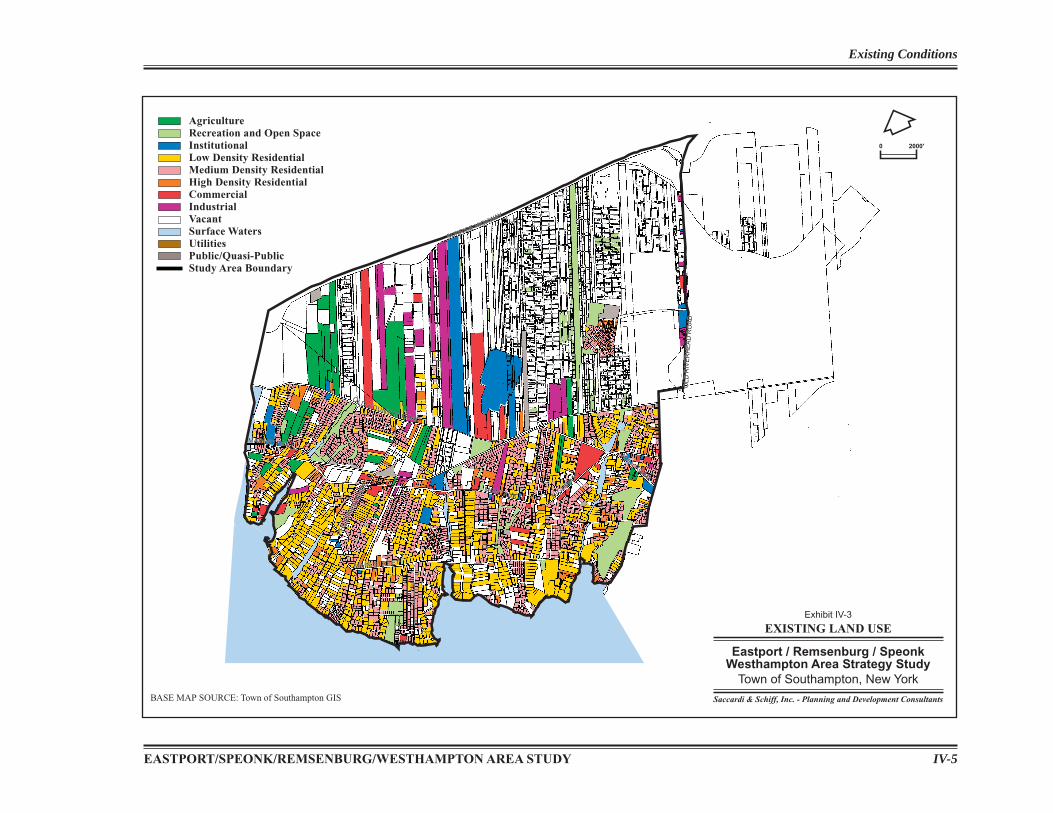
Exhibit IV-3 provides a graphic depiction of the existing land use pattern within the Study Area, which is primarily residential in nature, with selected exceptions in and around the hamlet cores, North Phillips Avenue and Speonk-Riverhead Road. Lands north of Old Country Road are primarily vacant; with agricultural, industrial and other commercial uses situated on large lots. The only signifi cant concentration of residential development located north of Old Country Road is Hampton West Park in Westhampton, located off of Old Riverhead Road. Provided below is a further description of the land use pattern.
Agricultural
There are approximately 350 acres of active agricultural lands within the Study Area. The primary agricultural uses are nurseries and fruit and vegetable farms. These lands often face signifi cant development pressures and the threat of diminishing farmland is real within Suffolk County.
The Town provides strategies for farmland preservation including the use of transfer or purchase of development rights (TDRs/PDRs). As previously discussed, through the use of TDRs, property owners can transfer development density to another property, in return for not developing further on the agricultural parcel. The Town can also purchase development rights from a farm property and allow the landowner to continue agricultural uses on-site, precluding any future development not related to farming – such as residential housing or commercial stores.
To slow the decline of farming, the County has also established a Farmland Preservation Program. This program allows the County to purchase the development rights of
4Record of Decision, BB&S Treated Lumber Corporation Site, Town of Southampton, Suffolk, Site Number 1-52-123; NYSDEC; February 2000.5Letter from NYSDEC, Ray E. Cowen, P.E., Regional Director; dated October 29, 2002.
EASTPORT/SPEONK/REMSENBURG/WESTHAMPTON AREA STUDY IV-5
Existing Conditions
EXISTING LAND USE
Eastport / Remsenburg / SpeonkWesthampton Area Strategy Study
Town of Southampton, New York
Saccardi & Schiff, Inc. - Planning and Development Consultants
Exhibit IV-3
AgricultureRecreation and Open SpaceInstitutionalLow Density ResidentialMedium Density ResidentialHigh Density ResidentialCommercialIndustrialVacantSurface WatersUtilitiesPublic/Quasi-PublicStudy Area Boundary
0 2000'
BASE MAP SOURCE: Town of Southampton GIS
SUNRISE HIGHWAY
OLD
RIV
ER
HE
AD
RO
AD
SUNRISE HIGHWAY
OLD
RIV
ER
HE
AD
RO
AD
MILLL ROAD
MILL ROAD
MONTAUKMONTAUK HIG
HWAY
HIGHW
AY
OLD COUNTRY ROAD
OLD COUNTRY ROAD
PH
ILLI
PS
AVE
NU
E
PH
ILLI
PS
AVE
NU
E
MAIN STREETMAIN STREET
MAIN STREETMAIN STREET
Saccardi & Schiff, Inc.IV-6
Existing Conditions
farmland; farmers then can continue to utilize the land for agricultural purposes, but no longer own the associated development rights, which would preclude residential development on residentially zoned tracts. As with the Town’s Farmland Preservation Program, farm buildings, however, can still be built on these agricultural properties.
The goal of the Farmland Preservation Program is to protect the most productive, prime agricultural soils in the county. Farmers who wish to be part of this program send letters to the Suffolk County Farmland Committee. The Committee utilizes a rating system for establishing a list of prioritized lands for preservation. The rating system looks at: soil type, development pressure; price; scenic vistas; and, contiguity to other preserved parcels.
Once this list is approved by resolution of the Suffolk County Division of Real Estate, appraisals are completed for each farm. The Real Estate Division then negotiates with the farmers for purchase of development rights. For farmlands to be eligible for this program, the land must consist of prime soils and have been actively farmed for at least the last two years.
Residential
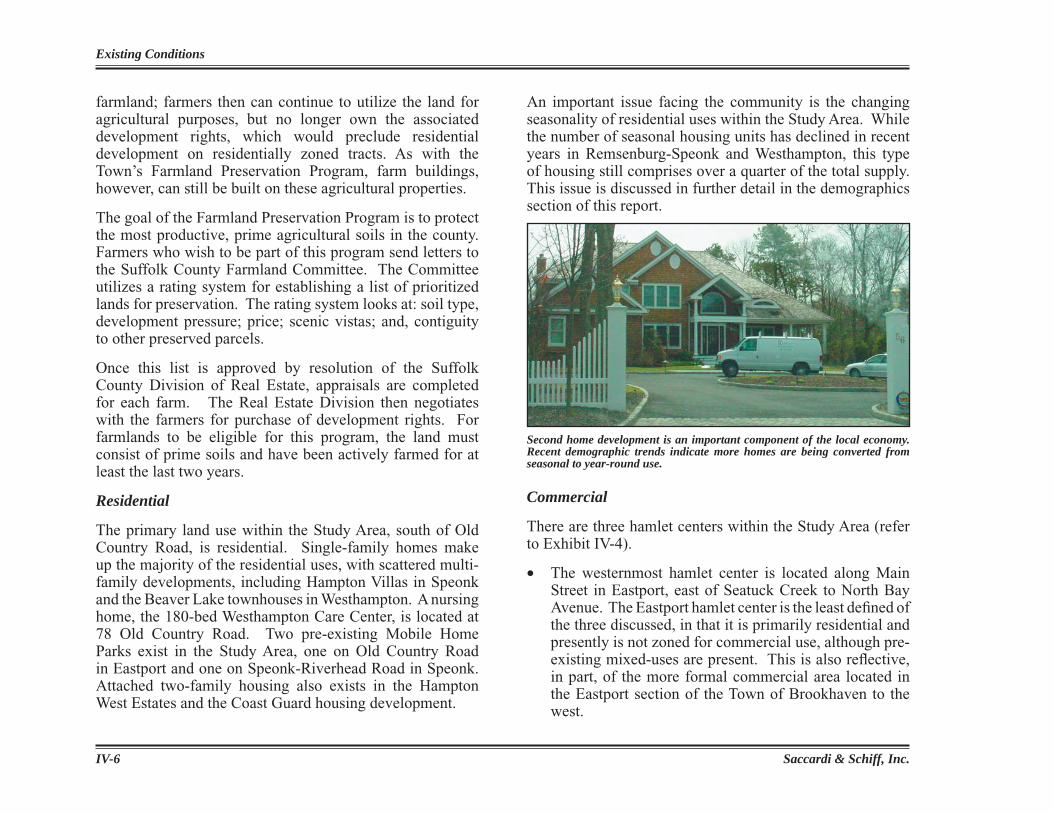
The primary land use within the Study Area, south of Old Country Road, is residential. Single-family homes make up the majority of the residential uses, with scattered multi-family developments, including Hampton Villas in Speonk and the Beaver Lake townhouses in Westhampton. A nursing home, the 180-bed Westhampton Care Center, is located at 78 Old Country Road. Two pre-existing Mobile Home Parks exist in the Study Area, one on Old Country Road in Eastport and one on Speonk-Riverhead Road in Speonk. Attached two-family housing also exists in the Hampton West Estates and the Coast Guard housing development.
An important issue facing the community is the changing seasonality of residential uses within the Study Area. While the number of seasonal housing units has declined in recent years in Remsenburg-Speonk and Westhampton, this type of housing still comprises over a quarter of the total supply. This issue is discussed in further detail in the demographics section of this report.
Commercial
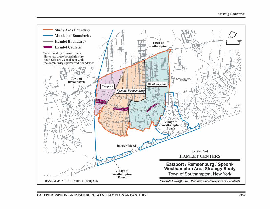
There are three hamlet centers within the Study Area (refer to Exhibit IV-4).
• The westernmost hamlet center is located along Main Street in Eastport, east of Seatuck Creek to North Bay Avenue. The Eastport hamlet center is the least defi ned of the three discussed, in that it is primarily residential and presently is not zoned for commercial use, although pre-existing mixed-uses are present. This is also refl ective, in part, of the more formal commercial area located in the Eastport section of the Town of Brookhaven to the west.
Second home development is an important component of the local economy. Recent demographic trends indicate more homes are being converted from seasonal to year-round use.
EASTPORT/SPEONK/REMSENBURG/WESTHAMPTON AREA STUDY IV-7
Existing Conditions
Study Area Boundary
Municipal Boundaries
Hamlet Boundary*
Hamlet Centers
As defined by Census Tracts.However, these boundaries arenot necessarily consistent withthe community’s perceived boundaries.
*
SUNRISE HIGHWAY
OLD
RIV
ER
HE
AD
SUNRISE HIGHWAY
OLD
RIV
ER
HE
AD
RD
SUFFOLK COUNTYAIRPORT
LIRR
LIRR
MILL
ROAD
MILL
ROADMONTAUKMONTAUK
HIGHW
AY
HIGHW
AY
OLD COUNTRY ROAD
OLD COUNTRY ROAD
PH
ILLI
PS
AVE
NU
E
PH
ILLI
PS
AVE
NU
E
MAIN STREETMAIN STREET
MAIN STREETMAIN STREET
SP
EO
NK
RIV
ER
HE
AD
RD
HAMLET CENTERS
Eastport / Remsenburg / SpeonkWesthampton Area Strategy Study
Town of Southampton, New York
Saccardi & Schiff, Inc. - Planning and Development Consultants
Exhibit IV-4
Speonk-RemsenburgEastport
Westhampton
0 4000'
Town ofBrookhaven
Town ofSouthampton
Village ofWesthampton
Dunes
Barrier Island
Village ofWesthampton
Beach
BASE MAP SOURCE: Suffolk County GIS
Saccardi & Schiff, Inc.IV-8
Existing Conditions
• The hamlet center in Speonk-Remsenburg is located along Montauk Highway between Phillips Avenue and the Speonk River.
• The hamlet center to the east along Montauk Highway in Westhampton extends from west of Seabreeze Avenue to just east of Station Road.
These two latter hamlet centers comprise the primary business centers in the Study Area.
In addition to the hamlet centers, the end of South Bay Avenue in Eastport contains waterfront resort businesses with a marina, a restaurant, a new catering facility, and two bed and breakfast establishments.
Recreation/Dedicated Open Space
The schools within the Study Area contain the main recreation fi elds for the area’s children and adults.
Speonk-Remsenburg School District facilities include:• 2 ballfi elds (baseball/softball)• 1 playground
Eastport/South Manor School District facilities include:• Eastport Elementary School• 1 Baseball fi eld• 1 Playground• 3 Tennis courts
Westhampton Beach School District facilities include:• 4 ballfi elds (baseball/softball)• 1 playground• 8 tennis courts• 1 football fi eld• 2 soccer fi elds• 2 outdoor basketball courts
Private recreational uses within the Study Area include:• The Westhampton Beach Golf and Country Club is
located at the southwestern boundary of the Study Area. • The private East Side Tennis Club is located on Montauk
Highway in Westhampton. • There are two private marinas at the southeastern
shores of the Study Area, one at the end of South Bay Avenue in Eastport and one at the end of Dock Road in Remsenburg.
• The Long Island Country Club has extensive property holdings that span both sides of Old Country Road from Seatuck Creek to the Sunrise Highway. The main building is located on the south side of Old Country Road.
Dedicated open space areas within the Study Area include:
• Hampton West Park Near the Hampton West Estates residential development
located on Stewart Avenue off of Old Riverhead Road, across from Gabreski Airport, Hampton Park West provides a 17-acre town recreation facility, with tennis courts, a baseball fi eld, soccer fi eld, basketball courts and playground. There is an opportunity to enhance access to this year-round park through directional signage and bicycle lanes, and by providing a connection to the existing and proposed trail system.
• Stokes Poges Tidal Marsh Stokes Poges Tidal Marsh, located in Remsenburg on
several parcels south of Main Street between Tuthill Lane and Halsey Road (land purchased through Community Preservation Funds and other land acquisition resources), has been identifi ed in an approved Management Plan for potential enhancement through wetland restoration and provisions of limited walking trails, a small-scale
EASTPORT/SPEONK/REMSENBURG/WESTHAMPTON AREA STUDY IV-9
Existing Conditions
• Tanners Neck Lane (Bay Beach Access);• Baycrest Avenue (Boat Basin).
The Board of Trustees for the Freeholders and Commonalty of Southampton Township (the Town Trustees) are stewards of the waterfront areas and key decision makers for planning processes impacting town bay bottoms, ponds, and public access points to waterways.
kayak launch and an observation station. The question has been raised within the community as to whether this sensitive land should be available to community access. The property is dedicated as a nature preserve.
• Cook’s Pond (Beaverdam Lake) This pond was dedicated to the Southampton Town
Trustees for park purposes when the subdivision of West Lake occurred. It has been suggested that a portion of the existing damaged fence should be removed and kayak launch area formalized so as to enhance access.
• Town-owned Park Property, Old Country Road This 15± acre property on Old Country Road adjacent
to “Water Hole” and north of the LIRR was dedicated to the Town for parks and recreation purposes as part of the subdivision process associated with the Mill Pond housing development
• CPF (Melzer) Property – Dock Road, Remsenburg Town-owned approximately 8-acre parcel that was
formerly part of the Melzer property purchased with CPF monies. This parcel is located adjacent to the Remsenburg Marina.
• Speonk River Greenbelt area, Montauk Highway Dedicated open space area part of the offi ce park/
institutional complex in Speonk on Montauk Highway (near North Fork Bank, former ActMedia building, etc.).
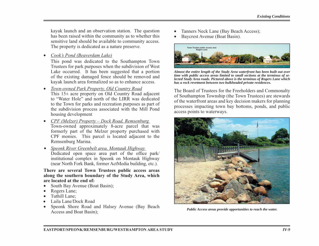
There are several Town Trustees public access areas along the southern boundary of the Study Area, which are located at the end of:• South Bay Avenue (Boat Basin);• Rogers Lane;• Tuthill Lane;• Laila Lane/Dock Road• Speonk Shore Road and Halsey Avenue (Bay Beach
Access and Boat Basin);
Town Trustee public access area Rogers Lane
Almost the entire length of the Study Area waterfront has been built out over time with public access areas limited to small sections at the terminus of se-lected Study Area roads. Pictured above is the terminus of Rogers Lane which has a rock revetment between two bulkheaded private residences.
Public Access areas provide opportunities to reach the water.
Saccardi & Schiff, Inc.IV-10
Existing Conditions
The right-of-way areas listed above are available to the public by the powers vested in the Town of Southampton Town Trustees, an elected fi ve-member board, whose responsibilities include, but are not limited to: preserving public access to the water; advising the Town Board on coastal related issues; maintaining and protecting surface water quality; regulating dock and bulkhead construction and impacts; and, inspecting all structures built on the bay bottom.
It is important to note that although other roads in the Study Area reach Moriches Bay, not all access points have the ability to be accessed by the public under Town Trustee easement standing and rights granted under the Dongan Patent. These other areas are private rights-of-way available only to those property owners whose deeds specify rights of access.
There is dedicated open space within the residential development along Drew Drive and Andy’s Lane south of Old Country Road in Speonk, and within the Hampton West Park accessed off of Old Riverhead Road in Westhampton.
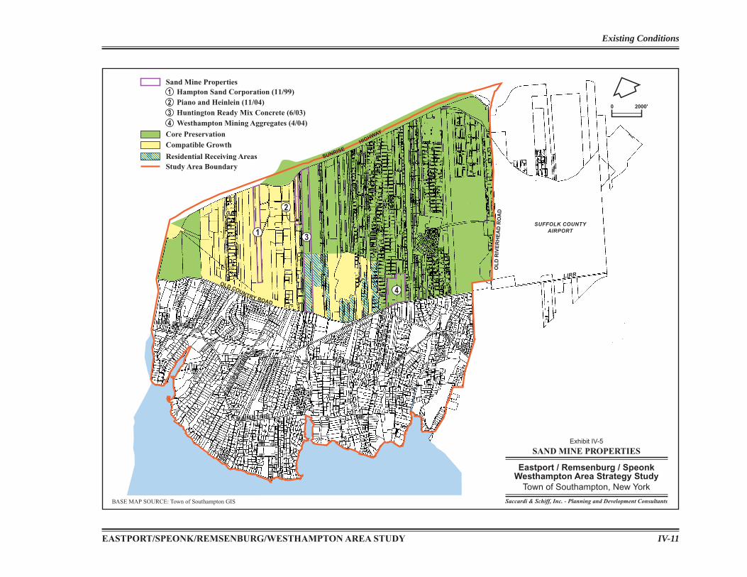
Sand Mines and IndustrialThere are four existing former or currently operating sand mine sites within the Study Area. (See Exhibit IV-5.) These include:
• Hampton Sand Corporation Thirty-six acres of this 50+-acre site had been issued
a New York State Department of Environmental Conservation (NYSDEC) mined land reclamation permit for sand and gravel. This permit expired in November 1999. The permitted mining area has been exhausted, and the land is to be reclaimed, regraded, and re-vegetated. A reclamation plan has been approved by the NYSDEC. This site is zoned CR-200 and is located within the Central Pine Barrens Compatible Growth Area.
• Piano and Heinlein Sand Mine
Over 13 acres of this 30+-acre site had been issued a NYSDEC mined land reclamation permit for sand and gravel. This permit is scheduled to expire in November 2004, however, it is anticipated that the permitted mining area will soon be exhausted.6 This site is zoned CR-200 and is located within the Central Pine Barrens Compatible Growth Area.
• Huntington Ready Mix Concrete Sand Mine Ninety-one acres of this approximate 115-acre site had been issued a NYSDEC mined land reclamation permit for sand and gravel. This permit expired in June 2003. It is unknown how many total acres have been mined. This site is zoned CR-200 and falls within both the Core Preservation Area and Compatible Growth Area of the Central Pine Barrens.
• Westhampton Mining Aggregates Sand and Gravel Mine Over 36 acres of this 50+-acre site had been issued a NYSDEC mined land reclamation permit for sand and gravel. This permit is scheduled to expire in April 2004; however, the permitted mining area has been exhausted. This site is zoned CR-200 and is located within the Central Pine Barrens Core Preservation Area.
There are several small, scattered areas of industrial use within this Study Area. A light industrial area located to the east of North Phillips Avenue is partly property owned by the Long Island Railroad (LIRR) and partly vacant. A second industrial area is located on Speonk-Riverhead Road in the Compatible Growth Area of the Central Pine Barrens
6Correspondence from Marty Shea, Chief Environmental Analyst, Town of Southampton, “Status of Sand Mines in Eastport, Speonk and Westhampton”, April 25, 2003.
EASTPORT/SPEONK/REMSENBURG/WESTHAMPTON AREA STUDY IV-11
Existing Conditions
1
2
3
4
Study Area Boundary
Core Preservation
Residential Receiving Areas
Compatible Growth
Sand Mine Properties1 Hampton Sand Corporation (11/99)2 Piano and Heinlein (11/04)3 Huntington Ready Mix Concrete (6/03)4 Westhampton Mining Aggregates (4/04)
SUNRISEHIGHWAY
OL
DR
IVE
RH
EA
DR
OA
D
SUFFOLK COUNTYAIRPORT
LIRR
MILL
ROAD
MILL
ROADMONTAUKMONTAUK
HIGHW
AY
HIGHW
AY
PH
ILLI
PS
AVE
NU
E
PH
ILLI
PS
AV
EN
UE
MAIN STREETMAIN STREET
MAIN STREETMAIN STREET
OLD COUNTRY ROAD
SAND MINE PROPERTIES
Eastport / Remsenburg / SpeonkWesthampton Area Strategy Study
Town of Southampton, New York
Saccardi & Schiff, Inc. - Planning and Development Consultants
Exhibit IV-5
0 2000'
BASE MAP SOURCE: Town of Southampton GIS
Saccardi & Schiff, Inc.IV-12
Existing Conditions
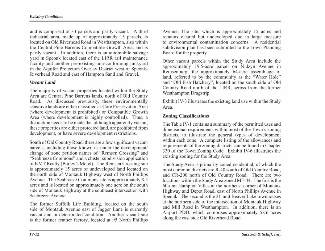
and is comprised of 33 parcels and partly vacant. A third industrial area, made up of approximately 15 parcels, is located on Old Riverhead Road in Westhampton, also within the Central Pine Barrens Compatible Growth Area, and is partly vacant. In addition, there is an automobile salvage yard in Speonk located east of the LIRR rail maintenance facility and another pre-existing non-conforming junkyard in the Aquifer Protection Overlay District west of Speonk-Riverhead Road and east of Hampton Sand and Gravel.
Vacant Land
The majority of vacant properties located within the Study Area are Central Pine Barrens lands, north of Old Country Road. As discussed previously, these environmentally sensitive lands are either classifi ed as Core Preservation Area (where development is prohibited) or Compatible Growth Area (where development is highly controlled). Thus, a distinction needs to be made that although apparently vacant, these properties are either protected land, are prohibited from development, or have severe development restrictions.
South of Old Country Road, there are a few signifi cant vacant parcels, including those known as under the development/change of zone petition names of “Remsen Crossing” and “Seabreeze Commons” and a cluster subdivision application of KMT Realty (Bailey’s Motel). The Remsen Crossing site is approximately 15 acres of undeveloped land located on the north side of Montauk Highway west of North Phillips Avenue. The Seabreeze Commons site is approximately 8.5 acres and is located on approximately one acre on the south side of Montauk Highway at the southeast intersection with Seabreeze Avenue.
The former Suffolk Life Building, located on the south side of Montauk Avenue east of Jagger Lane is currently vacant and in deteriorated condition. Another vacant site is the former feather factory, located at 95 North Phillips
Avenue, The site, which is approximately 15 acres and remains cleared but undeveloped due in large measure to environmental contamination concerns. A residential subdivision plan has been submitted to the Town Planning Board for the property.
Other vacant parcels within the Study Area include the approximately 19.5-acre parcel on Nidzyn Avenue in Remsenburg, the approximately 64-acre assemblage of land, referred to by the community as the “Water Hole” and “Old Fish Hatchery”, located on the south side of Old Country Road north of the LIRR, across from the former Westhampton Dragstrip.
Exhibit IV-3 illustrates the existing land use within the Study Area.
Zoning Classifi cations
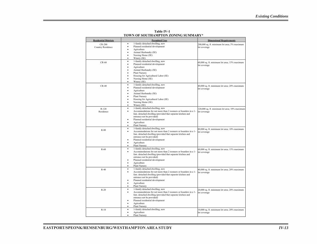
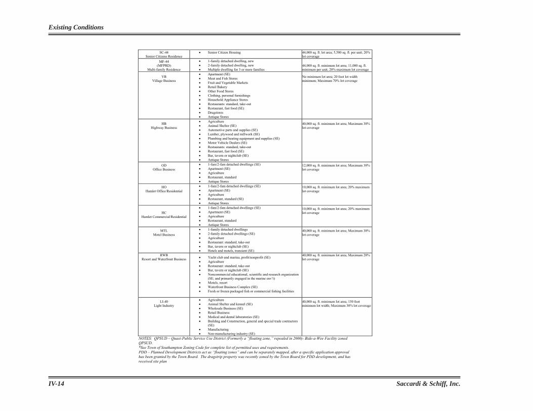
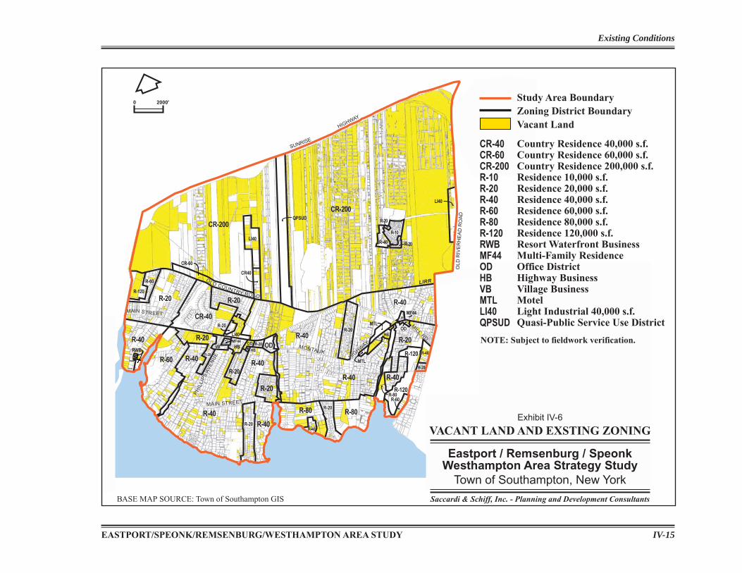
The Table IV-1 contains a summary of the permitted uses and dimensional requirements within most of the Town’s zoning districts, to illustrate the general types of development within each zone. A complete listing of the allowances and requirements of the zoning districts can be found in Chapter 330 of the Town Zoning Code. Exhibit IV-6 illustrates the existing zoning for the Study Area.
The Study Area is primarily zoned residential, of which the most common districts are R-40 south of Old Country Road, and CR-200 north of Old Country Road. There are two locations within the Study Area zoned MF-44. The fi rst is the 60-unit Hampton Villas at the northeast corner of Montauk Highway and Depot Road, east of North Phillips Avenue in Speonk. The second is the 21-unit Beaver Lake townhouses at the northern side of the intersection of Montauk Highway and Mill Road in Westhampton. In addition, there is an Airport PDD, which comprises approximately 58.6 acres along the east side Old Riverhead Road.
EASTPORT/SPEONK/REMSENBURG/WESTHAMPTON AREA STUDY IV-13
Existing Conditions
Table IV-1 TOWN OF SOUTHAMPTON ZONING SUMMARY*
Residential Districts Permitted Uses Dimensional Requirements
CR-200Country Residence
1-family detached dwelling, new Planned residential development Agriculture Animal Husbandry (SE) Nursing Home (SE) Winery (SE)
200,000 sq. ft. minimum lot area; 5% maximum lot coverage
CR-60 1-family detached dwelling, new Planned residential development Agriculture Animal Husbandry (SE) Plant Nursery Housing for Agricultural Labor (SE) Nursing Home (SE) Winery (SE)
60,000 sq. ft. minimum lot area; 15% maximum lot coverage
CR-40 1-family detached dwelling, new Planned residential development Agriculture Animal Husbandry (SE) Plant Nursery Housing for Agricultural Labor (SE) Nursing Home (SE) Winery (SE)
40,000 sq. ft. minimum lot area; 20% maximum lot coverage
R-120 Residence
1-family detached dwelling, new Accommodations for not more than 2 roomers or boarders in a 1-fam. detached dwelling (provided that separate kitchen and entrance not be provided) Planned residential development Agriculture Plant Nursery
120,000 sq. ft. minimum lot area; 10% maximum lot coverage
R-801-family detached dwelling, new Accommodations for not more than 2 roomers or boarders in a 1-fam. detached dwelling (provided that separate kitchen and entrance not be provided) Planned residential development Agriculture Plant Nursery
80,000 sq. ft. minimum lot area; 10% maximum lot coverage
R-60 1-family detached dwelling, new Accommodations for not more than 2 roomers or boarders in a 1-fam. detached dwelling (provided that separate kitchen and entrance not be provided) Planned residential development Agriculture Plant Nursery
60,000 sq. ft. minimum lot area; 15% maximum lot coverage
R-40 1-family detached dwelling, new Accommodations for not more than 2 roomers or boarders in a 1-fam. detached dwelling (provided that separate kitchen and entrance not be provided) Planned residential development Agriculture Plant Nursery
40,000 sq. ft. minimum lot area; 20% maximum lot coverage
R-20 1-family detached dwelling, new Accommodations for not more than 2 roomers or boarders in a 1-fam. detached dwelling (provided that separate kitchen and entrance not be provided) Planned residential development Agriculture Plant Nursery
20,000 sq. ft. minimum lot area; 20% maximum lot coverage
R-10 1-family detached dwelling, new Agriculture Plant Nursery
10,000 sq. ft. minimum lot area; 20% maximum lot coverage
Saccardi & Schiff, Inc.IV-14
Existing Conditions
SC-44Senior Citizens Residence
Senior Citizen Housing 44,000 sq. ft. lot area; 5,500 sq. ft. per unit; 20% lot coverage
MF-44(MFPRD)
Multi-family Residence
1-family detached dwelling, new 2-family detached dwelling, new Multiple dwelling for 3 or more families
44,000 sq. ft. minimum lot area; 11,000 sq. ft. minimum per unit; 20% maximum lot coverage
VBVillage Business
Apartment (SE) Meat and Fish Stores Fruit and Vegetable Markets Retail Bakery Other Food Stores Clothing, personal furnishings Household Appliance Stores Restaurants: standard, take-out Restaurant, fast food (SE) Drugstores Antique Stores
No minimum lot area; 20 foot lot width minimum; Maximum 70% lot coverage
HBHighway Business
Agriculture Animal Shelter (SE) Automotive parts and supplies (SE) Lumber, plywood and millwork (SE) Plumbing and heating equipment and supplies (SE) Motor Vehicle Dealers (SE) Restaurants: standard, take-out Restaurant, fast food (SE) Bar, tavern or nightclub (SE) Antique Stores
40,000 sq. ft. minimum lot area; Maximum 30% lot coverage
ODOffice Business
1-fam/2-fam detached dwellings (SE) Apartment (SE) Agriculture Restaurant, standard Antique Stores
12,000 sq. ft. minimum lot area; Maximum 30% lot coverage
HOHamlet Office/Residential
1-fam/2-fam detached dwellings (SE) Apartment (SE) Agriculture Restaurant, standard (SE) Antique Stores
10,000 sq. ft. minimum lot area; 20% maximum lot coverage
HCHamlet Commercial/Residential
1-fam/2-fam detached dwellings (SE) Apartment (SE) Agriculture Restaurant, standard Antique Stores
10,000 sq. ft. minimum lot area; 20% maximum lot coverage
MTLMotel Business
1-family detached dwellings 2-family detached dwellings (SE) Agriculture Restaurant: standard, take-out Bar, tavern or nightclub (SE) Hotels and motels, transient (SE)
40,000 sq. ft. minimum lot area; Maximum 30% lot coverage
RWB Resort and Waterfront Business Yacht club and marina, profit/nonprofit (SE)
Agriculture Restaurant: standard, take-out Bar, tavern or nightclub (SE) Noncommercial educational, scientific and research organization (SE; and primarily engaged in the marine env’t) Motels, resort Waterfront Business Complex (SE) Fresh or frozen packaged fish or commercial fishing facilities
40,000 sq. ft. minimum lot area; Maximum 20% lot coverage
LI-40 Light Industry
Agriculture Animal Shelter and kennel (SE) Wholesale Business (SE) Retail Business Medical and dental laboratories (SE) Building and Construction, general and special trade contractors (SE)Manufacturing Non-manufacturing industry (SE)
40,000 sq. ft. minimum lot area; 150 foot minimum lot width; Maximum 30% lot coverage
NOTES: QPSUD – Quasi-Public Service Use District (Formerly a “floating zone,” repealed in 2000)- Bide-a-Wee Facility zoned QPSUD.*See Town of Southampton Zoning Code for complete list of permitted uses and requirements. PDD – Planned Development Districts act as “floating zones” and can be separately mapped, after a specific application approvalhas been granted by the Town Board. The dragstrip property was recently zoned by the Town Board for PDD development, and has received site plan
EASTPORT/SPEONK/REMSENBURG/WESTHAMPTON AREA STUDY IV-15
Existing Conditions
OLD
RIV
ER
HE
AD
RO
AD
SUNRISE
HIGHWAY
OLD
RIV
ER
HE
AD
RO
AD
LIRR
OLDCO
UNTRY
ROAD
MONTAUK HIGHWAY
QU
OG
E-R
IVE
RH
EA
DR
OA
D
MILL
RD.
MILL
RD.MONTAUKMONTAUK
HIGHW
AY
HIGHW
AY
OLD COUNTRY ROAD
OLD COUNTRY ROAD
PH
ILLI
PS
AVE
NU
E
PH
ILLI
PS
AVE
NU
E
MAIN STREETMAIN STREET
MAIN STREETMAIN STREET
R-10
R-20
R-20R-40LI40
CR40
LI40
CR-200QPSUD
CR-60
R-20R-20
LI40
R-60
R-120
CR-200
R-20
R-40
R-20
CR-40
R-40
OD
R-40
R-80R-80
R-20
R-40
R-40
R-40
R-20
R-20
R-40R-60
R-20OD
HBVB
R-20
HB
R-20
R-20
R-40
R-80R-60
R-40
R-20
R-40
R-120
R-120
MTL
MTL
HB
MF44
OD
R-40
R-20
MF44
RWB
CR-40CR-60CR-200R-10R-20R-40R-60R-80R-120RWBMF44ODHBVBMTLLI40QPSUD
Country Residence 40,000 s.f.Country Residence 60,000 s.f.Country Residence 200,000 s.f.Residence 10,000 s.f.Residence 20,000 s.f.Residence 40,000 s.f.Residence 60,000 s.f.Residence 80,000 s.f.Residence 120,000 s.f.Resort Waterfront BusinessMulti-Family ResidenceOffice DistrictHighway BusinessVillage BusinessMotelLight Industrial 40,000 s.f.Quasi-Public Service Use District
NOTE: Subject to fieldwork verification.
Study Area BoundaryZoning District BoundaryVacant Land
VACANT LAND AND EXSTING ZONING
Eastport / Remsenburg / SpeonkWesthampton Area Strategy Study
Town of Southampton, New York
Saccardi & Schiff, Inc. - Planning and Development Consultants
Exhibit IV-6
0 2000'
BASE MAP SOURCE: Town of Southampton GIS
Saccardi & Schiff, Inc.IV-16
Existing Conditions
Each of the fi ve business districts can be found in the Study Area. The VB, HB and OD zoning designations are primarily concentrated along Montauk Highway, between North Phillips Avenue and the Speonk River. The MTL, HB and OD zones are located further east along Montauk Highway, from just west of Seabreeze Avenue to just east of Station Road in Westhampton. The RWB zoning district is located in the southeasternmost section of South Bay Avenue and currently includes a marina on the East River. There are three locations within the Study Area zoned LI-40: (1) east of North Phillips Avenue by the Speonk train station, (2) north of Old Country Road, along Speonk-Riverhead Road, which is partly vacant, and (3) Old Riverhead Road in Westhampton, across from the airport. The Study Area does not have any parcels zoned LI-200.
COMMUNITY FACILITIES
School Districts
The Study Area is divided among three school districts, including the Remsenburg-Speonk School District (RSUFSD), the Eastport/South Manor Central High School District (ESMCHSD) (resulting from a recent merger between the Eastport School District and the South Manor School District), and the Westhampton Beach School District (WHBUFSD). (See Exhibit IV-7.) The Remsenburg-Speonk School District contracts with the Westhampton
Beach School District for their middle- and high-school-aged students to attend Westhampton Beach schools. Each school district jurisdiction is administered by an elected Board of Education.
Fire Districts
The Study Area is bisected by two fi re districts: Eastport Fire District and Westhampton Beach Fire District. (See Exhibit IV-8, Fire District Boundaries.) The Eastport Fire District headquarters is located on Union Avenue in the Eastport section of the Town of Brookhaven. The Westhampton Beach Fire District headquarters is located at 108 Mill Road in the Incorporated Village of Westhampton Beach, west of the Study Area. These two fi re districts share a mutual aid agreement. An elected Board of Fire Commissioners administers each jurisdiction.
Ambulance
The Study Area is served by the Westhampton War Memorial Volunteer Ambulance Association for emergency medical service needs, which operates from a headquarters located in the Incorporated Village of Westhampton Beach at 3 Hazelwood Avenue, just east of the Study Area boundary. This volunteer Ambulance Corps serves an expansive area that covers the portion of Eastport in Southampton Town, Speonk-Remsenburg, Westhampton, Westhampton Beach, the Village of Westhampton Dunes, Quiogue, and the Village of Quogue.
Community Center
The Westhampton Community Center, located at 406 Mill Road, provides space for senior clubs, and small-scale community meetings, and also accommodates RSVP offi ce space needs. The Community Center was purchased from the local American Legion Chapter, and a condition of that sale
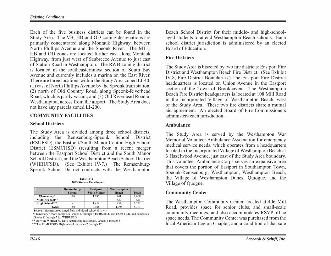
Table IV-2 2003 Student Enrollment
Remsenburg-Speonk
Eastport/ South Manor
Westhampton Beach Total:
Elementary* 180 1,987 441 2,608 Middle School** - - 422 422 High School*** - 1,419 932 2,351
Total: 180 3,406 1,795 5,381 Source: Information obtained from individual school districts. *Elementary School comprises Grades K through 6 for RSUFSD and ESMCHSD, and comprises Grades K through 5 for WHBUFSD. ** Only the WHBUFSD has a separate middle school, Grades 6 through 8. ***The ESMCHSD’s High School is Grades 7 through 12.