Embed Size (px)
Citation preview
SFO\131410001 iii ES052013145223BAO
COPYRIGHT 2013 BY CH2M HILL, INC.
Contents Section Page
Acronyms and Abbreviations ............................................................................................................................... v
1.0 Introduction ............................................................................................................................................ 1
2.0 Chemical Use Areas, Chemical Use Area Clusters, and Corrective Measures Study Areas ......................... 1
3.0 Comprehensive Data Quality Objectives Evaluation ................................................................................ 2 3.1 Unaffiliated Areas CUA Confirmation and Conditional NFA Area Documentation ............................. 2 3.2 Unaffiliated Areas Media‐specific DQO Evaluation ............................................................................. 3
4.0 Response to DTSC Comments on Draft RFI Reports ................................................................................. 3
5.0 Sampling and Analysis Plan ..................................................................................................................... 3 5.1 Sampling and Analysis Plan.................................................................................................................. 3
6.0 Schedule ................................................................................................................................................. 3
7.0 References .............................................................................................................................................. 4
Appendices
A Unaffiliated Areas Comprehensive Data Quality Objectives Evaluation B Responses to DTSC Comments Relevant to the Unaffiliated Areas C Unaffiliated Areas Data Gap Sampling and Analysis Plan
Tables
1a Current Status of DQO Evaluation for Unaffiliated Areas‐ Soil, Sediment, Soil Vapor, and Surface Water 1b Data Summary Table for Exceedances for Detected Results 1c Data Summary Table for Exceedances for Nondetect Results 2 Summary of Proposed Samples by Matrix within the Unaffiliated Areas 3 Schedule for Unaffiliated Areas Data Gap Work Plan Activities
Figures
1 Boeing RFI Subareas for Data Gap Categorization 2 Boeing Subarea 5/9 South Unaffiliated Areas
SFO\131410001 v ES052013145223BAO
COPYRIGHT 2013 BY CH2M HILL, INC.
Acronyms and Abbreviations Boeing The Boeing Company
CMS corrective measures study
CNFA conditional no further action
CUA chemical use area
DQO data quality objectives
DTSC California Environmental Protection Agency, Department of Toxic Substances Control
mg/kg milligrams per kilogram
MRL method reporting limit
NASA National Aeronautics and Space Administration
RBSL risk‐based screening level
RCRA Resource Conservation and Recovery Act
RFI RCRA facility investigation
RI remedial investigation
SAP sampling and analysis plan
SCL soil characterization level
SMOU Surficial Media Operable Unit
SSFL Santa Susana Field Laboratory
SVCL soil vapor characterization level
Unaffiliated Areas Subarea 5/9 South Areas Unaffiliated with RFI sites
SFO\131410001 1 ES052013145223BAO
COPYRIGHT 2013 BY CH2M HILL, INC.
Addendum to Master RCRA Facility Investigation Data Gap Work Plan, Boeing RFI Subarea 5/9 South, Areas Unaffiliated with RFI Sites, Santa Susana Field Laboratory, Ventura County, California
1.0 Introduction This addendum to the Master Resource Conservation and Recovery Act Facility Investigation Data Gap Work Plan, RCRA Facility Investigation, Santa Susana Field Laboratory, Ventura County, California (Master RFI Data Gap Work Plan) was prepared for The Boeing Company (Boeing) (CH2M HILL, 2013a) and relates to the areas within Boeing RFI Subarea 5/9 South that are unaffiliated with any Resource Conservation and Recovery Act (RCRA) facility investigation (RFI) site in Boeing RFI Subarea 5/9 South at the Santa Susana Field Laboratory (SSFL). The Areas Unaffiliated with RFI Sites within Boeing RFI Subarea 5/9 South (Unaffiliated Areas) consist of open space located outside the RFI site buffer boundaries within Boeing RFI Subarea 5/9 South. As presented in Figures 1 and 2, Boeing RFI Subarea 5/9 South includes:
The eastern portion of Group 5 located in Administrative Area III (includes the Systems Test Laboratory IV RFI site, Area III Sewage Treatment Plant RFI site, Compound A RFI site, and the southeast portion of the Environmental Effects Laboratory RFI site).
The southern portion of Group 9 located between Administrative Areas II and IV and south of Administrative Areas II, III, and IV.
Separate addenda to the Master RFI Data Gap Work Plan address the remaining portions of Boeing RFI Subarea 5/9 South. The Master RFI Data Gap Work Plan presents the overall framework and procedures to complete characterization of the nature and extent of contamination and to obtain necessary data to support corrective measures study (CMS) and conditional no further action (CNFA) recommendations1 for all portions of SSFL that are not subject to either the December 6, 2010 United States Department of Energy Administrative Order on Consent for Remedial Action or the December 6, 2010 National Aeronautics and Space Administration (NASA) Administrative Order on Consent for Remedial Action. The purpose of this addendum to the Boeing Master RFI Data Gap Work Plan is to:
Summarize the site characterization within the Unaffiliated Areas that has been completed to date.
Document the comprehensive data quality objective (DQO) evaluation for the Unaffiliated Areas (in Appendix A).
Respond to California Environmental Protection Agency, Department of Toxic Substances Control (DTSC) comments, when received (in Appendix B).
Present the proposed data gap work plan for the Unaffiliated Areas, which presents the plan for addressing data gaps, if any, identified through the DQO evaluation process (in Appendix C).
2.0 Chemical Use Areas, Chemical Use Area Clusters, and Corrective Measures Study Areas
To date, no chemical use areas (CUAs), CUA clusters, or CMS areas have been identified within the Unaffiliated Areas. All sampling locations within the Unaffiliated Areas were compared to the most recent soil characterization
1 A CNFA recommendation is based on current site information and weight-of-evidence documentation but is considered conditional pending resolution of Senate Bill 990, findings from future building demolition, and determination of background concentrations, analytical method reporting limits (MRLs), and final regulatory requirements.
ADDENDUM TO MASTER RCRA FACILITY INVESTIGATION DATA GAP WORK PLAN, BOEING RFI SUBAREA 5/9 SOUTH, AREAS UNAFFILIATED WITH RFI SITES, SANTA SUSANA FIELD LABORATORY, VENTURA COUNTY, CALIFORNIA
2 SFO\131410001 ES052013145223BAO
COPYRIGHT 2013 BY CH2M HILL, INC.
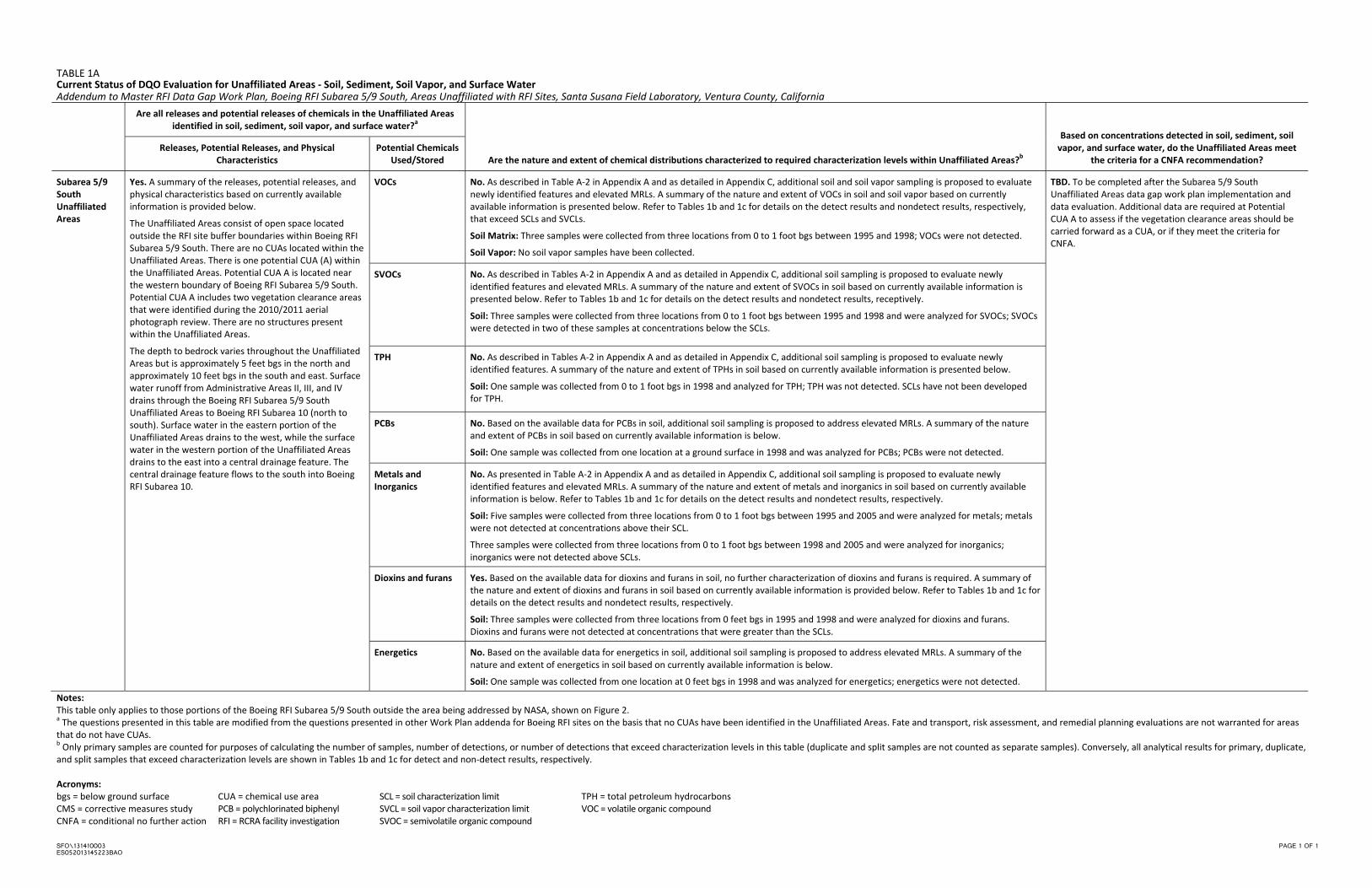
levels2 (SCLs) and soil vapor characterization levels (SVCLs). Table 1a presents a summary of the nature and extent of contamination and the contaminant fate‐and‐transport evaluations that have been performed to date within the Unaffiliated Areas. Tables 1b and 1c present summaries of exceedances for detected and non‐detect results, respectively, within the Unaffiliated Areas.
Two sampling locations (CABS0514 and CABS0515) are associated with the NASA Coca RFI Site but are within the Unaffiliated Areas. Since the Coca area is being investigated by NASA, it is not assessed further in this Work Plan. The portion of the Unaffiliated Areas that is currently being investigated by NASA is shown on Figure 2.
Because CUAs, CUA clusters, or CMS areas have not been identified within the Unaffiliated Areas, media‐specific DQO evaluations are not applicable.
3.0 Comprehensive Data Quality Objectives Evaluation Data gaps for the Unaffiliated Areas were identified by evaluating the DQOs identified in Comprehensive Data Quality Objectives, RCRA Facility Investigation, Santa Susana Field Laboratory, Ventura County, California (DQO Report) (CH2M HILL, 2013b) relative to the data and information specific to the Unaffiliated Areas. The data gaps that were identified within the Unaffiliated Areas through this process are presented in Appendix A.
3.1 Unaffiliated Areas CUA Confirmation and Conditional NFA Area Documentation
In accordance with the DQO Report (CH2M HILL, 2013b) and the Master RFI Data Gap Work Plan (CH2M HILL, 2013a), Appendix A to this document includes Tables A‐1 and A‐2, which contain the CNFA Area Weight of Evidence Documentation for the Surficial Media Operable Unit (SMOU) and the CUA Confirmation Status for newly identified features within the Unaffiliated Areas. Table A‐1 presents a comprehensive summary of the weight‐of‐evidence assessment of any potential release of any chemical within the Unaffiliated Areas for each of the activities listed in DQO Report Figure 2. Any potential release that has not already been identified, investigated, and documented in the Group 5 – Central Portions of Areas III and IV RCRA Facility Investigation Report, Santa Susana Field Laboratory, Ventura County, California (Group 5 RFI Report) (CH2M HILL, 2008) or in the Draft Group 9 Remedial Investigation Report (Group 9 RI Report) (NASA, 2009) is identified in Table A‐1 (highlighted yellow in Table A‐1) and carried forward into Table A‐2. The information presented in Table A‐1 for portions of the Unaffiliated Areas where a potential release of any chemical is not identified (highlighted magenta in Table A‐1) will be used to support a future CNFA recommendation for those portions of the Unaffiliated Areas.
Table A‐2 presents specific information on the newly identified releases and potential releases within the Unaffiliated Areas and the planned approach for addressing these potential releases. In accordance with DQO Report Figure 2, each new potential release identified in Table A‐2 is identified as a potential CUA and is subjected to a screening‐level investigation in accordance with DQO Report Table 2 (for suspect features). Table A‐2 presents the one potential CUA (highlighted yellow in Table A‐2) that requires a screening‐level investigation to determine whether a new release or potential release3 exists and to determine if the potential CUA should be carried forward as a new CUA and subjected to the media‐specific DQO evaluation. Appendix A also includes Figure A‐1, which presents the locations of the newly identified features and the potential CUA identified within
2 The SCLs used to prepare this work plan are the 2005 background levels, the suburban residential risk-based screening levels (RBSLs) included in the May 2012 Gold Copy hard-drive deliverable, and the low-toxicity-reference-value-based ecological RBSLs for soil included in the May 2012 Gold Copy hard-drive deliverable. The background levels and select RBSLs were updated in 2012 while this work plan was in development. The updated background levels and RBSLs will be used in future evaluations of data gaps for the Unaffiliated Areas in accordance with the comprehensive DQO process. The background levels for aluminum, arsenic, and orthophosphate have changed significantly since 2005. Consequently, the most recent background levels for these three chemicals (37,900 milligrams per kilogram [mg/kg], 24.2 mg/kg, and 863.2 mg/kg, respectively) were considered during the evaluation of soil data gaps. The SVCLs used to prepare this work plan are the residential SVCLs presented in Recommended Approach for Assessing the Vapor Intrusion Pathway, Boeing RFI Project, SSFL (CH2M HILL, 2013c) and the low-toxicity-reference-value-based ecological RBSLs for soil vapor included in the May 2012 Gold Copy hard-drive deliverable (CH2M HILL, 2012). 3 A new release or potential release is one that has not already been identified, investigated, and documented in the Group 5 RFI Report (CH2M HILL, 2008) or in the Group 9 RI Report (NASA, 2009). A new release or potential release can result in identification of a new CUA or can represent a new source and/or new chemical(s) associated with an existing CUA.
ADDENDUM TO MASTER RCRA FACILITY INVESTIGATION DATA GAP WORK PLAN, BOEING RFI SUBAREA 5/9 SOUTH, AREAS UNAFFILIATED WITH RFI SITES, SANTA SUSANA FIELD LABORATORY, VENTURA COUNTY, CALIFORNIA
SFO\131410001 3 ES052013145223BAO
COPYRIGHT 2013 BY CH2M HILL, INC.
the Unaffiliated Areas. Proposed samples to investigate the newly identified release or potential release are identified in Table C‐1, Unaffiliated Areas Data Gap Sampling and Analysis in Appendix C.
3.2 Unaffiliated Areas Media-specific DQO Evaluation Based on the approach presented in the DQO Report (CH2M HILL, 2013b), the media‐specific DQO evaluation is conducted for each new and existing CUA, which are grouped into CUA clusters based on similarities in geographic proximity, operational history, analytical parameters, and related factors. The CUA clusters are then subject to the media‐specific DQO process for surface water, soil and sediment, vadose zone, and groundwater and seeps.
As described in Section 2.0, no CUAs or CUA clusters have been identified within the Unaffiliated Areas. Therefore, the media‐specific DQO evaluation is not required at this time. As described in Section 3.1, one potential CUA has been identified in the Unaffiliated Areas that requires a screening‐level investigation. The outcome of the screening‐level investigation will help determine if the potential CUA should be identified as a new CUA. If a new CUA is identified, media‐specific DQO evaluations will then be performed.
It is also important to recognize that there may be media impacts in the Unaffiliated Areas that are associated with CUA clusters in adjacent or nearby RFI sites. These impacts may include contaminant transport (e.g., air, surface water, groundwater, vapor intrusion) from the RFI site into the Unaffiliated Areas. Per the DQO process, the nature, extent, fate, and transport of contaminants are evaluated for the RFI site where the source is located. This evaluation may result in the identification of CMS areas that extend from the RFI site into the Unaffiliated Areas, or will provide further evidence supporting CNFA for the Unaffiliated Areas.
4.0 Response to DTSC Comments on Draft RFI Reports No comments that were received from the California Environmental Protection Agency, Department of Toxic Substances Control (DTSC) Geological Services Unit on the Group 5 RFI Report (CH2M HILL, 2008; DTSC, 2009, 2010) or the Group 9 RI Report (NASA, 2009; DTSC, 2011a‐b) pertained directly to the Unaffiliated Areas. Any comments that are received in the future that pertain to the Unaffiliated Areas, along with the corresponding responses to those comments, will be provided in Appendix B.
5.0 Sampling and Analysis Plan This data gap work plan consists of a field SAP to address the RFI analytical data gaps that have been identified for the Unaffiliated Areas.
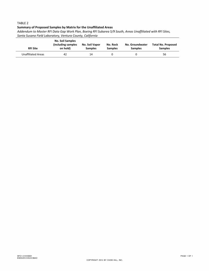
5.1 Sampling and Analysis Plan The Unaffiliated Areas Data Gap sampling and analysis plan (SAP) to address the data gaps identified in Appendix A is presented in Appendix C. Appendix C includes a table that lists the sample media, sample depth, and analytical groups for each proposed sample (Table C‐1) and a table that lists the analytical method proposed for each analytical group (Table C‐2). In addition, the rationale and the specific DQOs that the proposed sample are intended to satisfy are identified in Table C‐1 for each sample. Figure C‐1 in Appendix C presents the locations of the proposed samples. A summary of the samples proposed for collection within the Unaffiliated Areas is presented in Table 2.
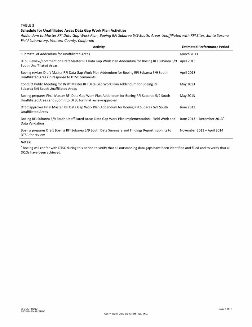
6.0 Schedule The schedule for implementing the Unaffiliated Areas Data Gap Work Plan is presented in Table 3. The table also presents the activities and associated performance periods that are anticipated to collect all data necessary to support the final CMS area and NFA area conclusions for the Unaffiliated Areas.
ADDENDUM TO MASTER RCRA FACILITY INVESTIGATION DATA GAP WORK PLAN, BOEING RFI SUBAREA 5/9 SOUTH, AREAS UNAFFILIATED WITH RFI SITES, SANTA SUSANA FIELD LABORATORY, VENTURA COUNTY, CALIFORNIA
4 SFO\131410001 ES052013145223BAO
COPYRIGHT 2013 BY CH2M HILL, INC.
7.0 References CH2M HILL. 2008. Group 5 – Central Portions of Areas III and IV RCRA Facility Investigation Report, Santa Susana
Field Laboratory, Ventura County, California. November.
CH2M HILL. 2010. Site‐wide Debris Removal and Documentation Summary, Santa Susana Field Laboratory, Ventura County, California. October.
CH2M HILL. 2012. SSFL Sitewide Gold Copy GIS Mapping and Analytical Geodatabase System (hard‐drive deliverable). May.
CH2M HILL. 2013a. Master Resource Conservation and Recovery Act Facility Investigation Work Plan. March.
CH2M HILL. 2013b. Comprehensive Data Quality Objectives, RCRA Facility Investigation, Santa Susana Field Laboratory, Ventura County, California. March.
CH2M HILL. 2013c. Recommended Approach for Assessing the Vapor Intrusion Pathway, Boeing RCRA Facility Investigation Project, Santa Susana Field Laboratory. March. (Appendix A to DQO Report).
California Environmental Protection Agency, Department of Toxic Substances Control (DTSC). 2009. Memorandum from Laura Rainey/DTSC to Gerard Abrams/DTSC. “Comments on Group 5 – Central Portion of Areas III and IV – RCRA Facility Investigation Report, Santa Susana Field Laboratory, Ventura County, California.” December 9.
California Environmental Protection Agency, Department of Toxic Substances Control (DTSC). 2010. Memorandum from Thomas M. Seckington/DTSC to Gerard Abrams/DTSC. “Group 5 RFI Report.” January 25.
California Environmental Protection Agency, Department of Toxic Substances Control (DTSC). 2011a. Memorandum from Mark Malinowski/DTSC to Allen Elliott/NASA. “DTSC Comments on Group 9 Remedial Investigation Report, Santa Susana Field Laboratory, Ventura County, CA.” March 30.
California Environmental Protection Agency, Department of Toxic Substances Control (DTSC). 2011b. Memorandum from Mark Malinowski/DTSC to Randy Ueshiro/Boeing. “DTSC Comments on Group 9 Remedial Investigation Report, Santa Susana Field Laboratory, Ventura County, CA.” March 30.
Montgomery Watson Harza International (MWH). 2009. Site‐Wide Groundwater Remedial Investigation Report.
National Aeronautics and Space Administration (NASA). 2009. Draft Group 9 Remedial Investigation Report. November.

Tables
SFO\131410003 PAGE 1 OF 1 ES052013145223BAO
TABLE 1A Current Status of DQO Evaluation for Unaffiliated Areas ‐ Soil, Sediment, Soil Vapor, and Surface Water Addendum to Master RFI Data Gap Work Plan, Boeing RFI Subarea 5/9 South, Areas Unaffiliated with RFI Sites, Santa Susana Field Laboratory, Ventura County, California
Are all releases and potential releases of chemicals in the Unaffiliated Areas identified in soil, sediment, soil vapor, and surface water?a
Are the nature and extent of chemical distributions characterized to required characterization levels within Unaffiliated Areas?b
Based on concentrations detected in soil, sediment, soil vapor, and surface water, do the Unaffiliated Areas meet
the criteria for a CNFA recommendation? Releases, Potential Releases, and Physical
Characteristics Potential Chemicals
Used/Stored
Subarea 5/9 South Unaffiliated Areas
Yes. A summary of the releases, potential releases, and physical characteristics based on currently available information is provided below.
The Unaffiliated Areas consist of open space located outside the RFI site buffer boundaries within Boeing RFI Subarea 5/9 South. There are no CUAs located within the Unaffiliated Areas. There is one potential CUA (A) within the Unaffiliated Areas. Potential CUA A is located near the western boundary of Boeing RFI Subarea 5/9 South. Potential CUA A includes two vegetation clearance areas that were identified during the 2010/2011 aerial photograph review. There are no structures present within the Unaffiliated Areas.
The depth to bedrock varies throughout the Unaffiliated Areas but is approximately 5 feet bgs in the north and approximately 10 feet bgs in the south and east. Surface water runoff from Administrative Areas II, III, and IV drains through the Boeing RFI Subarea 5/9 South Unaffiliated Areas to Boeing RFI Subarea 10 (north to south). Surface water in the eastern portion of the Unaffiliated Areas drains to the west, while the surface water in the western portion of the Unaffiliated Areas drains to the east into a central drainage feature. The central drainage feature flows to the south into Boeing RFI Subarea 10.
VOCs No. As described in Table A‐2 in Appendix A and as detailed in Appendix C, additional soil and soil vapor sampling is proposed to evaluate newly identified features and elevated MRLs. A summary of the nature and extent of VOCs in soil and soil vapor based on currently available information is presented below. Refer to Tables 1b and 1c for details on the detect results and nondetect results, respectively, that exceed SCLs and SVCLs.
Soil Matrix: Three samples were collected from three locations from 0 to 1 foot bgs between 1995 and 1998; VOCs were not detected.
Soil Vapor: No soil vapor samples have been collected.
TBD. To be completed after the Subarea 5/9 South Unaffiliated Areas data gap work plan implementation and data evaluation. Additional data are required at Potential CUA A to assess if the vegetation clearance areas should be carried forward as a CUA, or if they meet the criteria for CNFA.
SVOCs No. As described in Tables A‐2 in Appendix A and as detailed in Appendix C, additional soil sampling is proposed to evaluate newly identified features and elevated MRLs. A summary of the nature and extent of SVOCs in soil based on currently available information is presented below. Refer to Tables 1b and 1c for details on the detect results and nondetect results, receptively.
Soil: Three samples were collected from three locations from 0 to 1 foot bgs between 1995 and 1998 and were analyzed for SVOCs; SVOCs were detected in two of these samples at concentrations below the SCLs.
TPH No. As described in Tables A‐2 in Appendix A and as detailed in Appendix C, additional soil sampling is proposed to evaluate newly identified features. A summary of the nature and extent of TPHs in soil based on currently available information is presented below.
Soil: One sample was collected from 0 to 1 foot bgs in 1998 and analyzed for TPH; TPH was not detected. SCLs have not been developed for TPH.
PCBs No. Based on the available data for PCBs in soil, additional soil sampling is proposed to address elevated MRLs. A summary of the nature and extent of PCBs in soil based on currently available information is below.
Soil: One sample was collected from one location at a ground surface in 1998 and was analyzed for PCBs; PCBs were not detected.
Metals and Inorganics
No. As presented in Table A‐2 in Appendix A and as detailed in Appendix C, additional soil sampling is proposed to evaluate newly identified features and elevated MRLs. A summary of the nature and extent of metals and inorganics in soil based on currently available information is below. Refer to Tables 1b and 1c for details on the detect results and nondetect results, respectively.
Soil: Five samples were collected from three locations from 0 to 1 foot bgs between 1995 and 2005 and were analyzed for metals; metals were not detected at concentrations above their SCL.
Three samples were collected from three locations from 0 to 1 foot bgs between 1998 and 2005 and were analyzed for inorganics; inorganics were not detected above SCLs.
Dioxins and furans Yes. Based on the available data for dioxins and furans in soil, no further characterization of dioxins and furans is required. A summary of the nature and extent of dioxins and furans in soil based on currently available information is provided below. Refer to Tables 1b and 1c for details on the detect results and nondetect results, respectively.
Soil: Three samples were collected from three locations from 0 feet bgs in 1995 and 1998 and were analyzed for dioxins and furans. Dioxins and furans were not detected at concentrations that were greater than the SCLs.
Energetics No. Based on the available data for energetics in soil, additional soil sampling is proposed to address elevated MRLs. A summary of the nature and extent of energetics in soil based on currently available information is below.
Soil: One sample was collected from one location at 0 feet bgs in 1998 and was analyzed for energetics; energetics were not detected.
Notes: This table only applies to those portions of the Boeing RFI Subarea 5/9 South outside the area being addressed by NASA, shown on Figure 2. a The questions presented in this table are modified from the questions presented in other Work Plan addenda for Boeing RFI sites on the basis that no CUAs have been identified in the Unaffiliated Areas. Fate and transport, risk assessment, and remedial planning evaluations are not warranted for areas that do not have CUAs. b Only primary samples are counted for purposes of calculating the number of samples, number of detections, or number of detections that exceed characterization levels in this table (duplicate and split samples are not counted as separate samples). Conversely, all analytical results for primary, duplicate, and split samples that exceed characterization levels are shown in Tables 1b and 1c for detect and non‐detect results, respectively. Acronyms: bgs = below ground surface CUA = chemical use area SCL = soil characterization limit TPH = total petroleum hydrocarbons CMS = corrective measures study PCB = polychlorinated biphenyl SVCL = soil vapor characterization limit VOC = volatile organic compound CNFA = conditional no further action RFI = RCRA facility investigation SVOC = semivolatile organic compound
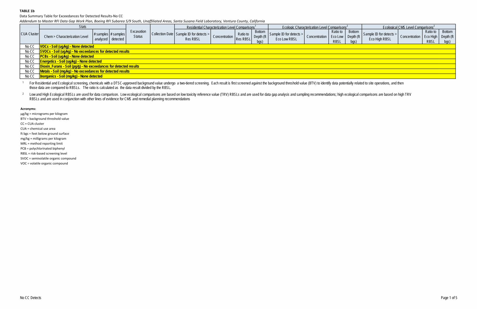
TABLE 1b
Data Summary Table for Exceedances for Detected Results‐No CC
Addendum to Master RFI Data Gap Work Plan, Boeing RFI Subarea 5/9 South, Unaffiliated Areas, Santa Susana Field Laboratory, Ventura County, California
Chem > Characterization Level # samples analyzed
# samples detected
Sample ID for detects > Res RBSL Concentration Ratio to
Res RBSL
Bottom Depth (ft
bgs)
Sample ID for detects > Eco Low RBSL Concentration
Ratio to Eco Low
RBSL
Bottom Depth (ft
bgs)
Sample ID for detects > Eco High RBSL Concentration
Ratio to Eco High
RBSL
Bottom Depth (ft
bgs)No CCNo CCNo CCNo CCNo CCNo CCNo CC
Energetics - Soil (ug/kg) - None detectedDioxin_Furans - Soil (pg/g) - No exceedances for detected resultsMetals - Soil (mg/kg) - No exceedances for detected resultsInorganics - Soil (mg/kg) - None detected
Ecologic Characterization Level Comparisons2 Ecological CMS Level Comparisons2
VOCs - Soil (ug/kg) - None detectedSVOCs - Soil (ug/kg) - No exceedances for detected resultsPCBs - Soil (ug/kg) - None detected
CUA Cluster
StatsExcavation
Status Collection DateResidential Characterization Level Comparisons1
1 For Residential and Ecological screening, chemicals with a DTSC-approved background value undergo a two-tiered screening. Each result is first screened against the background threshold value (BTV) to identify data potentially related to site operations, and then those data are compared to RBSLs. The ratio is calculated as the data result divided by the RBSL.
2 Low and High Ecological RBSLs are used for data comparison. Low ecological comparisons are based on low toxicity reference value (TRV) RBSLs and are used for data gap analysis and sampling recommendations; high ecological comparisons are based on high TRV
Acronyms:
µg/kg = micrograms per kilogram
BTV = background threshold value
CC = CUA cluster
CUA = chemical use area
ft bgs = feet below ground surface
mg/kg = milligrams per kilogram
MRL = method reporting limit
PCB = polychlorinated biphenyl
RBSL = risk‐based screening level
SVOC = semivolatile organic compound
VOC = volatile organic compound
g g p g p y ( ) g p y p g ; g g p gRBSLs and are used in conjunction with other lines of evidence for CMS and remedial planning recommendations
No CC Detects Page 1 of 5
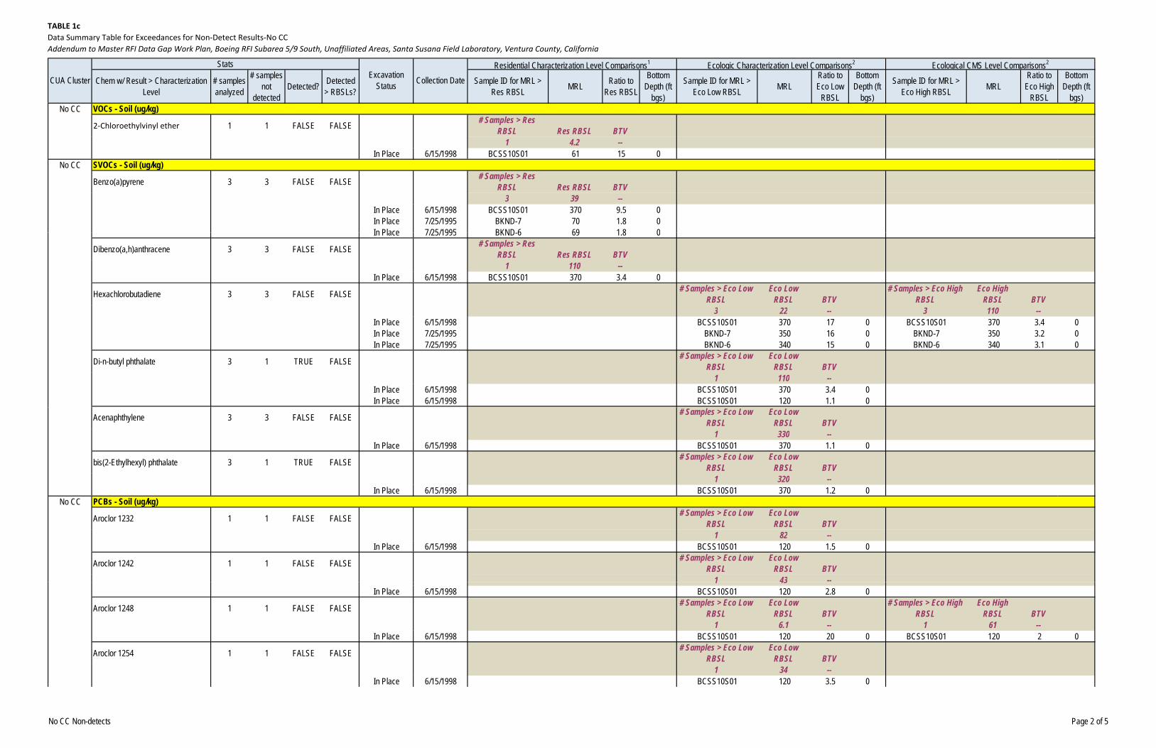
TABLE 1c
Data Summary Table for Exceedances for Non‐Detect Results‐No CC
Addendum to Master RFI Data Gap Work Plan, Boeing RFI Subarea 5/9 South, Unaffiliated Areas, Santa Susana Field Laboratory, Ventura County, California
Chem w/ Result > Characterization Level
# samples analyzed
# samples not
detectedDetected? Detected
> RBSLs?Sample ID for MRL >
Res RBSL MRL Ratio to Res RBSL
Bottom Depth (ft
bgs)
Sample ID for MRL > Eco Low RBSL MRL
Ratio to Eco Low
RBSL
Bottom Depth (ft
bgs)
Sample ID for MRL > Eco High RBSL MRL
Ratio to Eco High
RBSL
Bottom Depth (ft
bgs)No CC
2‐Chloroethylvinyl ether 1 1 FALSE FALSE # Samples > Res RBSL Res RBSL BTV
1 4.2 --In Place 6/15/1998 BCSS10S01 61 15 0
No CC
Benzo(a)pyrene 3 3 FALSE FALSE # Samples > Res RBSL Res RBSL BTV
3 39 --In Place 6/15/1998 BCSS10S01 370 9.5 0In Place 7/25/1995 BKND-7 70 1.8 0In Place 7/25/1995 BKND 6 69 1 8 0
Ecologic Characterization Level Comparisons2 Ecological CMS Level Comparisons2
VOCs - Soil (ug/kg)
SVOCs - Soil (ug/kg)
CUA Cluster
StatsExcavation
Status Collection DateResidential Characterization Level Comparisons1
In Place 7/25/1995 BKND-6 69 1.8 0
Dibenzo(a,h)anthracene 3 3 FALSE FALSE # Samples > Res RBSL Res RBSL BTV
1 110 --In Place 6/15/1998 BCSS10S01 370 3.4 0
Hexachlorobutadiene 3 3 FALSE FALSE # Samples > Eco Low RBSL
Eco Low RBSL BTV
# Samples > Eco High RBSL
Eco High RBSL BTV
3 22 -- 3 110 --In Place 6/15/1998 BCSS10S01 370 17 0 BCSS10S01 370 3.4 0In Place 7/25/1995 BKND-7 350 16 0 BKND-7 350 3.2 0In Place 7/25/1995 BKND-6 340 15 0 BKND-6 340 3.1 0
Di-n-butyl phthalate 3 1 TRUE FALSE # Samples > Eco Low RBSL
Eco Low RBSL BTV
1 110 --In Place 6/15/1998 BCSS10S01 370 3.4 0In Place 6/15/1998 BCSS10S01 120 1.1 0
Acenaphthylene 3 3 FALSE FALSE # Samples > Eco Low RBSL
Eco Low RBSL BTV
1 330 --In Place 6/15/1998 BCSS10S01 370 1.1 0
bis(2-Ethylhexyl) phthalate 3 1 TRUE FALSE # Samples > Eco Low RBSL
Eco Low RBSL BTV
1 320 --In Place 6/15/1998 BCSS10S01 370 1.2 0
No CC
Aroclor 1232 1 1 FALSE FALSE # Samples > Eco Low RBSL
Eco Low RBSL BTV
1 82 --In Place 6/15/1998 BCSS10S01 120 1.5 0
Aroclor 1242 1 1 FALSE FALSE # Samples > Eco Low RBSL
Eco Low RBSL BTV
1 43 --
PCBs - Soil (ug/kg)
1 43In Place 6/15/1998 BCSS10S01 120 2.8 0
Aroclor 1248 1 1 FALSE FALSE # Samples > Eco Low RBSL
Eco Low RBSL BTV
# Samples > Eco High RBSL
Eco High RBSL BTV
1 6.1 -- 1 61 --In Place 6/15/1998 BCSS10S01 120 20 0 BCSS10S01 120 2 0
Aroclor 1254 1 1 FALSE FALSE # Samples > Eco Low RBSL
Eco Low RBSL BTV
1 34 --In Place 6/15/1998 BCSS10S01 120 3.5 0
No CC Non-detects Page 2 of 5
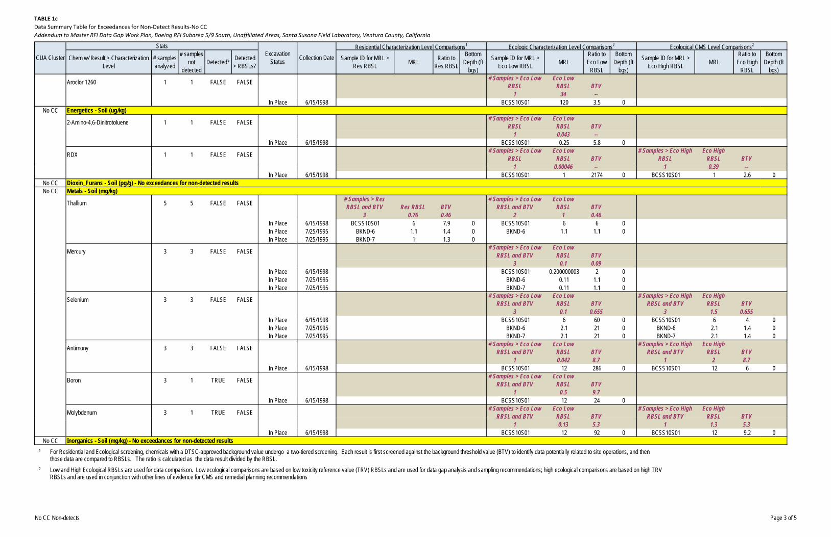
TABLE 1c
Data Summary Table for Exceedances for Non‐Detect Results‐No CC
Addendum to Master RFI Data Gap Work Plan, Boeing RFI Subarea 5/9 South, Unaffiliated Areas, Santa Susana Field Laboratory, Ventura County, California
Chem w/ Result > Characterization Level
# samples analyzed
# samples not
detectedDetected? Detected
> RBSLs?Sample ID for MRL >
Res RBSL MRL Ratio to Res RBSL
Bottom Depth (ft
bgs)
Sample ID for MRL > Eco Low RBSL MRL
Ratio to Eco Low
RBSL
Bottom Depth (ft
bgs)
Sample ID for MRL > Eco High RBSL MRL
Ratio to Eco High
RBSL
Bottom Depth (ft
bgs)
Ecologic Characterization Level Comparisons2 Ecological CMS Level Comparisons2
CUA Cluster
StatsExcavation
Status Collection DateResidential Characterization Level Comparisons1
Aroclor 1260 1 1 FALSE FALSE # Samples > Eco Low RBSL
Eco Low RBSL BTV
1 34 --In Place 6/15/1998 BCSS10S01 120 3.5 0
No CC
2-Amino-4,6-Dinitrotoluene 1 1 FALSE FALSE # Samples > Eco Low RBSL
Eco Low RBSL BTV
1 0.043 --In Place 6/15/1998 BCSS10S01 0.25 5.8 0
RDX 1 1 FALSE FALSE # Samples > Eco Low RBSL
Eco Low RBSL BTV
# Samples > Eco High RBSL
Eco High RBSL BTV
1 0 00046 -- 1 0 39 --
Energetics - Soil (ug/kg)
1 0.00046 -- 1 0.39 --In Place 6/15/1998 BCSS10S01 1 2174 0 BCSS10S01 1 2.6 0
No CCNo CC
Thallium 5 5 FALSE FALSE # Samples > Res RBSL and BTV Res RBSL BTV
# Samples > Eco Low RBSL and BTV
Eco Low RBSL BTV
3 0.76 0.46 2 1 0.46In Place 6/15/1998 BCSS10S01 6 7.9 0 BCSS10S01 6 6 0In Place 7/25/1995 BKND-6 1.1 1.4 0 BKND-6 1.1 1.1 0In Place 7/25/1995 BKND-7 1 1.3 0
Mercury 3 3 FALSE FALSE # Samples > Eco Low RBSL and BTV
Eco Low RBSL BTV
3 0.1 0.09In Place 6/15/1998 BCSS10S01 0.200000003 2 0In Place 7/25/1995 BKND-6 0.11 1.1 0In Place 7/25/1995 BKND-7 0.11 1.1 0
Dioxin_Furans - Soil (pg/g) - No exceedances for non-detected resultsMetals - Soil (mg/kg)
Selenium 3 3 FALSE FALSE # Samples > Eco Low RBSL and BTV
Eco Low RBSL BTV
# Samples > Eco High RBSL and BTV
Eco High RBSL BTV
3 0.1 0.655 3 1.5 0.655In Place 6/15/1998 BCSS10S01 6 60 0 BCSS10S01 6 4 0In Place 7/25/1995 BKND-6 2.1 21 0 BKND-6 2.1 1.4 0In Place 7/25/1995 BKND-7 2.1 21 0 BKND-7 2.1 1.4 0
Antimony 3 3 FALSE FALSE # Samples > Eco Low RBSL and BTV
Eco Low RBSL BTV
# Samples > Eco High RBSL and BTV
Eco High RBSL BTV
1 0.042 8.7 1 2 8.7In Place 6/15/1998 BCSS10S01 12 286 0 BCSS10S01 12 6 0
Boron 3 1 TRUE FALSE # Samples > Eco Low RBSL and BTV
Eco Low RBSL BTV
1 0.5 9.7In Place 6/15/1998 BCSS10S01 12 24 0
Molybdenum 3 1 TRUE FALSE # Samples > Eco Low RBSL and BTV
Eco Low RBSL BTV
# Samples > Eco High RBSL and BTV
Eco High RBSL BTVRBSL and BTV RBSL BTV RBSL and BTV RBSL BTV
1 0.13 5.3 1 1.3 5.3In Place 6/15/1998 BCSS10S01 12 92 0 BCSS10S01 12 9.2 0
No CC Inorganics - Soil (mg/kg) - No exceedances for non-detected results1 For Residential and Ecological screening, chemicals with a DTSC-approved background value undergo a two-tiered screening. Each result is first screened against the background threshold value (BTV) to identify data potentially related to site operations, and then
those data are compared to RBSLs. The ratio is calculated as the data result divided by the RBSL.2 Low and High Ecological RBSLs are used for data comparison. Low ecological comparisons are based on low toxicity reference value (TRV) RBSLs and are used for data gap analysis and sampling recommendations; high ecological comparisons are based on high TRV
RBSLs and are used in conjunction with other lines of evidence for CMS and remedial planning recommendations
No CC Non-detects Page 3 of 5
TABLE 1c
Data Summary Table for Exceedances for Non‐Detect Results‐No CC
Addendum to Master RFI Data Gap Work Plan, Boeing RFI Subarea 5/9 South, Unaffiliated Areas, Santa Susana Field Laboratory, Ventura County, California
Chem w/ Result > Characterization Level
# samples analyzed
# samples not
detectedDetected? Detected
> RBSLs?Sample ID for MRL >
Res RBSL MRL Ratio to Res RBSL
Bottom Depth (ft
bgs)
Sample ID for MRL > Eco Low RBSL MRL
Ratio to Eco Low
RBSL
Bottom Depth (ft
bgs)
Sample ID for MRL > Eco High RBSL MRL
Ratio to Eco High
RBSL
Bottom Depth (ft
bgs)
Ecologic Characterization Level Comparisons2 Ecological CMS Level Comparisons2
CUA Cluster
StatsExcavation
Status Collection DateResidential Characterization Level Comparisons1
Acronyms:
µg/kg = micrograms per kilogram
BTV = background threshold value
CC = CUA cluster
CUA = chemical use area
ft bgs = feet below ground surface
mg/kg = milligrams per kilogram
MRL = method reporting limit
PCB = polychlorinated biphenyl
RBSL = risk‐based screening level
SO = soil
SVOC = semivolatile organic compoundSVOC = semivolatile organic compound
VOC = volatile organic compound
No CC Non-detects Page 4 of 5
General Notes for Tables 1b and 1c:
‐ This table only lists chemicals for which a characterization level exists. The soil characterization levels used in preparing these summary tables are the 2005 background
levels, the suburban residential RBSLs included in the May 2012 Gold Copy hard‐drive deliverable, and the low toxicity reference value‐based ecological RBSLs for soil
included in the May 2012 Gold Copy hard‐drive deliverable. The background levels and select RBSLs were updated in 2012 while this work plan was in development. The
updated background levels and RBSLs will be used in future evaluations of data gaps for the STL‐IV RFI site, in accordance with the comprehensive DQO process. The
background levels for aluminum, arsenic, and orthophosphate have changed significantly since 2005. Consequently, the most recent background levels for these three
chemicals (37,900, 24.2, and 863.2 milligrams per kilogram, respectively) were considered during the evaluation of soil data gaps. The SVCLs used in preparing this work
plan are the residential SVCLs presented in Recommended Approach for Assessing the Vapor Intrusion Pathway, Boeing RFI Project, SSFL (CH2M HILL, 2013c) and the low
toxicity reference value‐based ecological RBSLs for soil vapor included in the May 2012 Gold Copy hard‐drive deliverable.
‐ Chemicals listed as VOC in Vapor Screens represent the total VOCs concentration measured using a field screening method.
‐ For non‐detect results, chemical characterization levels are compared against the practical quantification limits (PQL) as the method reporting limits. If PQL values were
not available, the method detection limits were used for the comparisons.SO = Soil
SFO\131410001 PAGE 1 OF 1 ES052013145223BAO
COPYRIGHT 2013 BY CH2M HILL, INC.
TABLE 2 Summary of Proposed Samples by Matrix for the Unaffiliated AreasAddendum to Master RFI Data Gap Work Plan, Boeing RFI Subarea 5/9 South, Areas Unaffiliated with RFI Sites, Santa Susana Field Laboratory, Ventura County, California
RFI Site
No. Soil Samples (including samples
on hold) No. Soil Vapor
Samples No. Rock Samples
No. Groundwater Samples
Total No. Proposed Samples
Unaffiliated Areas 42 14 0 0 56
SFO\131410001 PAGE 1 OF 1 ES052013145223BAO
COPYRIGHT 2013 BY CH2M HILL, INC.
TABLE 3 Schedule for Unaffiliated Areas Data Gap Work Plan ActivitiesAddendum to Master RFI Data Gap Work Plan, Boeing RFI Subarea 5/9 South, Areas Unaffiliated with RFI Sites, Santa Susana Field Laboratory, Ventura County, California
Activity Estimated Performance Period
Submittal of Addendum for Unaffiliated Areas March 2013
DTSC Review/Comment on Draft Master RFI Data Gap Work Plan Addendum for Boeing RFI Subarea 5/9 South Unaffiliated Areas
April 2013
Boeing revises Draft Master RFI Data Gap Work Plan Addendum for Boeing RFI Subarea 5/9 South Unaffiliated Areas in response to DTSC comments
April 2013
Conduct Public Meeting for Draft Master RFI Data Gap Work Plan Addendum for Boeing RFI Subarea 5/9 South Unaffiliated Areas
May 2013
Boeing prepares Final Master RFI Data Gap Work Plan Addendum for Boeing RFI Subarea 5/9 South Unaffiliated Areas and submit to DTSC for final review/approval
May 2013
DTSC approves Final Master RFI Data Gap Work Plan Addendum for Boeing RFI Subarea 5/9 South Unaffiliated Areas
June 2013
Boeing RFI Subarea 5/9 South Unaffiliated Areas Data Gap Work Plan Implementation ‐ Field Work and Data Validation
June 2013 – December 2013a
Boeing prepares Draft Boeing RFI Subarea 5/9 South Data Summary and Findings Report; submits to DTSC for review
November 2013 – April 2014
Notes: a Boeing will confer with DTSC during this period to verify that all outstanding data gaps have been identified and filled and to verify that all DQOs have been achieved.
Figures
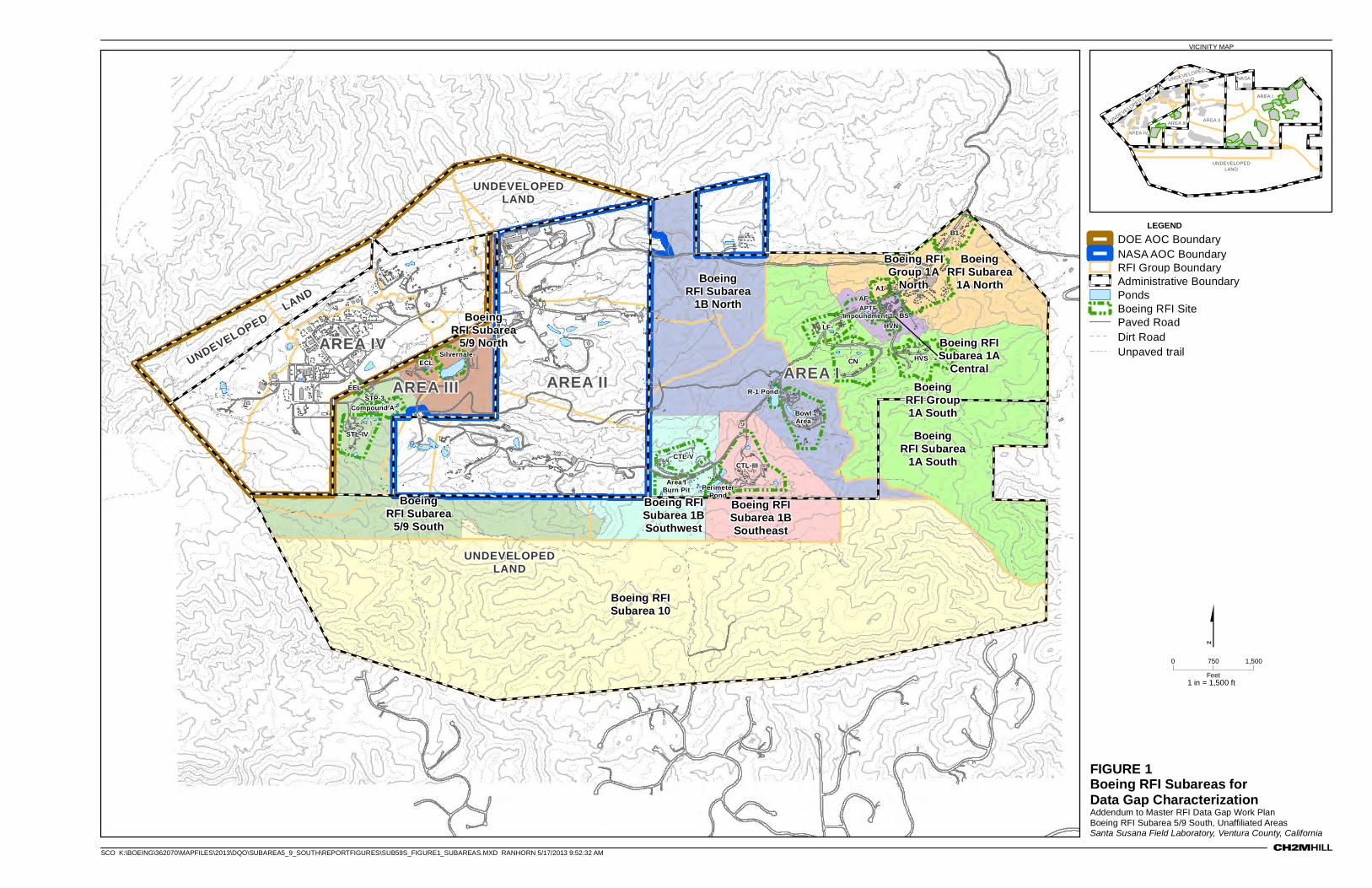
FIGURE 1Boeing RFI Subareas for Data Gap CharacterizationAddendum to Master RFI Data Gap Work PlanBoeing RFI Subarea 5/9 South, Unaffiliated AreasSanta Susana Field Laboratory, Ventura County, California
VICINITY MAP
UNDEVELOPEDLAND
UNDEVELOPEDLAND
UNDEVELOPED LAND
AREA IAREA II
AREA IV
AREA III
Boeing RFISubarea 1A
Central
BoeingRFI Subarea
1A South
BoeingRFI Subarea
1A NorthAPTF
Impoundment 1
A1IL
LF
CN
AF
B1
HVS
BSHVN
ECL
Area IBurn Pit
EEL R-1 Pond
BowlArea
STL-IV
STP-3Compound A
Silvernale
CTL-III
PerimeterPond
CTL-V
BoeingRFI Subarea
1B North
Boeing RFISubarea 10
Boeing RFISubarea 1BSoutheast
Boeing RFISubarea 1BSouthwest
BoeingRFI Subarea
5/9 North
BoeingRFI Subarea
5/9 South
BoeingRFI Group1A South
Boeing RFIGroup 1A
North
0 1,500750
Feet
NASA
AREA I
AREA II
AREA IV
AREA III
UNDEVELOPEDLAND
UNDEVELOPED
LAND
UNDEVELOPED LAND
$1 in = 1,500 ft
SCO K:\BOEING\362070\MAPFILES\2013\DQO\SUBAREA5_9_SOUTH\REPORTFIGURES\SUB59S_FIGURE1_SUBAREAS.MXD RANHORN 5/17/2013 9:52:32 AM
LEGENDDOE AOC BoundaryNASA AOC BoundaryRFI Group BoundaryAdministrative BoundaryPondsBoeing RFI SitePaved RoadDirt RoadUnpaved trail
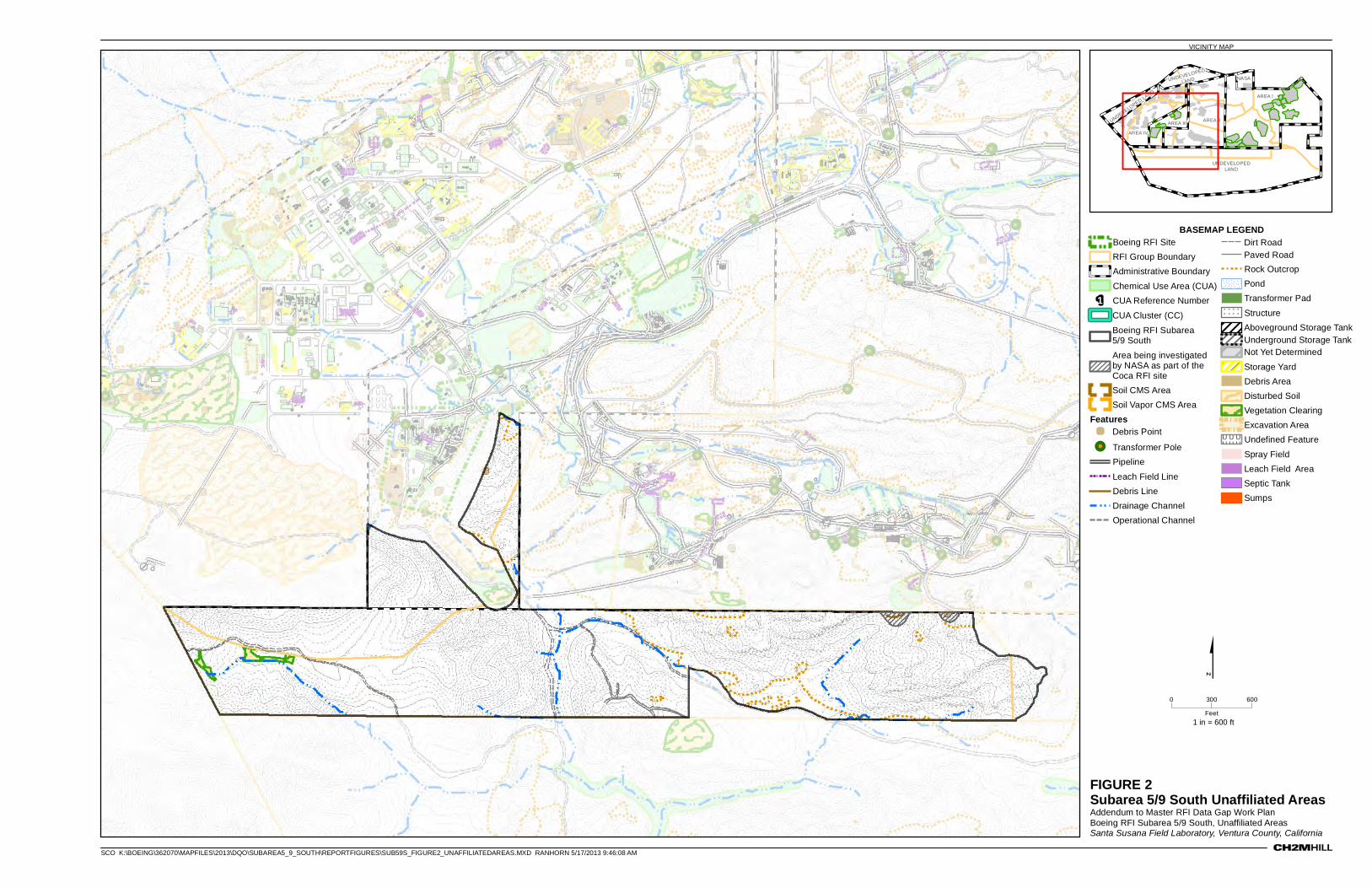
FIGURE 2Subarea 5/9 South Unaffiliated AreasAddendum to Master RFI Data Gap Work PlanBoeing RFI Subarea 5/9 South, Unaffiliated AreasSanta Susana Field Laboratory, Ventura County, California
VICINITY MAP
0 600300
Feet
BASEMAP LEGENDBoeing RFI Site
RFI Group Boundary
Administrative Boundary
Chemical Use Area (CUA)
1 CUA Reference Number
CUA Cluster (CC)
Boeing RFI Subarea 5/9 South
Area being investigated by NASA as part of the Coca RFI site
Soil CMS Area
Soil Vapor CMS Area
Features' Debris Point
!! Transformer Pole
Pipeline
Leach Field Line
Debris Line
Drainage Channel
Operational Channel
Dirt RoadPaved Road
Rock Outcrop
Pond
Transformer Pad
! ! ! ! ! !
! ! ! ! ! !
! ! ! ! ! !
Structure
Aboveground Storage TankUnderground Storage TankNot Yet Determined
Storage Yard
Debris Area
Disturbed Soil
Vegetation Clearing
Excavation Area
U U U U UU U U U UU U U U UUndefined Feature
Spray Field
Leach Field Area
Septic Tank
Sumps
NASA
AREA I
AREA II
AREA IV
AREA III
UNDEVELOPEDLAND
UNDEVELOPED
LAND
UNDEVELOPED LAND
$1 in = 600 ft
SCO K:\BOEING\362070\MAPFILES\2013\DQO\SUBAREA5_9_SOUTH\REPORTFIGURES\SUB59S_FIGURE2_UNAFFILIATEDAREAS.MXD RANHORN 5/17/2013 9:46:08 AM
Appendix A Unaffiliated Areas Comprehensive DQO Evaluation
SFO\131410001 A-1 ES052013145223BAO
COPYRIGHT 2013 BY CH2M HILL, INC.
Appendix A Contents CUA Confirmation and Conditional NFA Area Weight of Evidence Documentation
Table A‐1: Conditional NFA Weight of Evidence Documentation for the Boeing RFI Subarea 5/9 South Unaffiliated Areas
Table A‐2: Potential CUA Confirmation and Supplemental Conditional NFA Area Weight of Evidence Documentation for the SMOU, Boeing RFI Subarea 5/9 South Unaffiliated Areas
Figure A‐1: New Identified Features and Potential CUA within the Boeing RFI Subarea 5/9 South Unaffiliated Areas
Figure A‐2: Comparison of Analytical Results to Characterization Levels for Soil from 0 to 2 Feet Below Ground Surface, Subarea 5/9 South Unaffiliated Areas
Figure A‐3: Comparison of Analytical Results to Characterization Levels for Soil from 2 to 10 Feet Below Ground Surface, Subarea 5/9 South Unaffiliated Areas
Figure A‐4: Comparison of Analytical Results to Characterization Levels for VOCs (Soil and Soil Vapor) from 0 to 10 Feet Below Ground Surface, Subarea 5/9 South Unaffiliated Areas
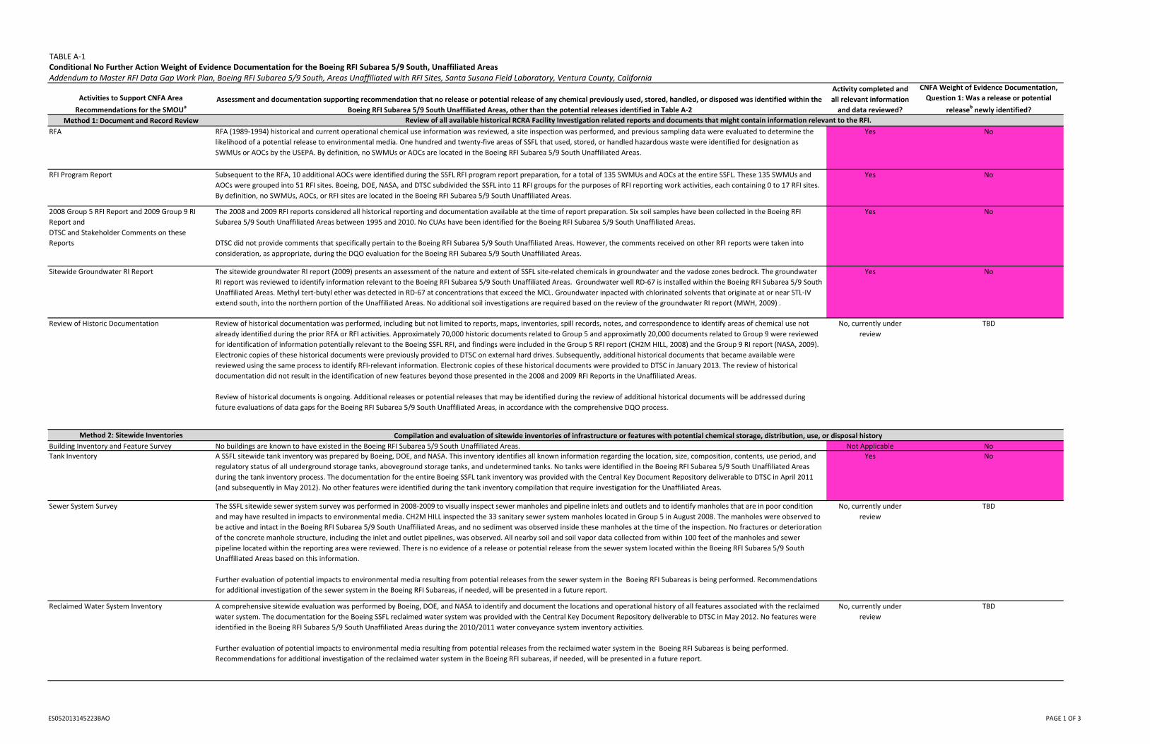
TABLE A‐1Conditional No Further Action Weight of Evidence Documentation for the Boeing RFI Subarea 5/9 South, Unaffiliated Areas Addendum to Master RFI Data Gap Work Plan, Boeing RFI Subarea 5/9 South, Areas Unaffiliated with RFI Sites, Santa Susana Field Laboratory, Ventura County, California
Activities to Support CNFA Area
Recommendations for the SMOUa
Assessment and documentation supporting recommendation that no release or potential release of any chemical previously used, stored, handled, or disposed was identified within the
Boeing RFI Subarea 5/9 South Unaffiliated Areas, other than the potential releases identified in Table A‐2
Activity completed and
all relevant information
and data reviewed?
CNFA Weight of Evidence Documentation,
Question 1: Was a release or potential
releasebnewly identified?
Method 1: Document and Record Review
RFA RFA (1989‐1994) historical and current operational chemical use information was reviewed, a site inspection was performed, and previous sampling data were evaluated to determine the
likelihood of a potential release to environmental media. One hundred and twenty‐five areas of SSFL that used, stored, or handled hazardous waste were identified for designation as
SWMUs or AOCs by the USEPA. By definition, no SWMUs or AOCs are located in the Boeing RFI Subarea 5/9 South Unaffiliated Areas.
Yes No
RFI Program Report Subsequent to the RFA, 10 additional AOCs were identified during the SSFL RFI program report preparation, for a total of 135 SWMUs and AOCs at the entire SSFL. These 135 SWMUs and
AOCs were grouped into 51 RFI sites. Boeing, DOE, NASA, and DTSC subdivided the SSFL into 11 RFI groups for the purposes of RFI reporting work activities, each containing 0 to 17 RFI sites.
By definition, no SWMUs, AOCs, or RFI sites are located in the Boeing RFI Subarea 5/9 South Unaffiliated Areas.
Yes No
2008 Group 5 RFI Report and 2009 Group 9 RI
Report and
DTSC and Stakeholder Comments on these
Reports
The 2008 and 2009 RFI reports considered all historical reporting and documentation available at the time of report preparation. Six soil samples have been collected in the Boeing RFI
Subarea 5/9 South Unaffiliated Areas between 1995 and 2010. No CUAs have been identified for the Boeing RFI Subarea 5/9 South Unaffiliated Areas.
DTSC did not provide comments that specifically pertain to the Boeing RFI Subarea 5/9 South Unaffiliated Areas. However, the comments received on other RFI reports were taken into
consideration, as appropriate, during the DQO evaluation for the Boeing RFI Subarea 5/9 South Unaffiliated Areas.
Yes No
Sitewide Groundwater RI Report The sitewide groundwater RI report (2009) presents an assessment of the nature and extent of SSFL site‐related chemicals in groundwater and the vadose zones bedrock. The groundwater
RI report was reviewed to identify information relevant to the Boeing RFI Subarea 5/9 South Unaffiliated Areas. Groundwater well RD‐67 is installed within the Boeing RFI Subarea 5/9 South
Unaffiliated Areas. Methyl tert‐butyl ether was detected in RD‐67 at concentrations that exceed the MCL. Groundwater inpacted with chlorinated solvents that originate at or near STL‐IV
extend south, into the northern portion of the Unaffiliated Areas. No additional soil investigations are required based on the review of the groundwater RI report (MWH, 2009) .
Yes No
Review of Historic Documentation Review of historical documentation was performed, including but not limited to reports, maps, inventories, spill records, notes, and correspondence to identify areas of chemical use not
already identified during the prior RFA or RFI activities. Approximately 70,000 historic documents related to Group 5 and approximatly 20,000 documents related to Group 9 were reviewed
for identification of information potentially relevant to the Boeing SSFL RFI, and findings were included in the Group 5 RFI report (CH2M HILL, 2008) and the Group 9 RI report (NASA, 2009).
Electronic copies of these historical documents were previously provided to DTSC on external hard drives. Subsequently, additional historical documents that became available were
reviewed using the same process to identify RFI‐relevant information. Electronic copies of these historical documents were provided to DTSC in January 2013. The review of historical
documentation did not result in the identification of new features beyond those presented in the 2008 and 2009 RFI Reports in the Unaffiliated Areas.
Review of historical documents is ongoing. Additional releases or potential releases that may be identified during the review of additional historical documents will be addressed during
future evaluations of data gaps for the Boeing RFI Subarea 5/9 South Unaffiliated Areas, in accordance with the comprehensive DQO process.
No, currently under
review
TBD
Method 2: Sitewide Inventories
Building Inventory and Feature Survey No buildings are known to have existed in the Boeing RFI Subarea 5/9 South Unaffiliated Areas. Not Applicable No
Tank Inventory A SSFL sitewide tank inventory was prepared by Boeing, DOE, and NASA. This inventory identifies all known information regarding the location, size, composition, contents, use period, and
regulatory status of all underground storage tanks, aboveground storage tanks, and undetermined tanks. No tanks were identified in the Boeing RFI Subarea 5/9 South Unaffiliated Areas
during the tank inventory process. The documentation for the entire Boeing SSFL tank inventory was provided with the Central Key Document Repository deliverable to DTSC in April 2011
(and subsequently in May 2012). No other features were identified during the tank inventory compilation that require investigation for the Unaffiliated Areas.
Yes No
Sewer System Survey The SSFL sitewide sewer system survey was performed in 2008‐2009 to visually inspect sewer manholes and pipeline inlets and outlets and to identify manholes that are in poor condition
and may have resulted in impacts to environmental media. CH2M HILL inspected the 33 sanitary sewer system manholes located in Group 5 in August 2008. The manholes were observed to
be active and intact in the Boeing RFI Subarea 5/9 South Unaffiliated Areas, and no sediment was observed inside these manholes at the time of the inspection. No fractures or deterioration
of the concrete manhole structure, including the inlet and outlet pipelines, was observed. All nearby soil and soil vapor data collected from within 100 feet of the manholes and sewer
pipeline located within the reporting area were reviewed. There is no evidence of a release or potential release from the sewer system located within the Boeing RFI Subarea 5/9 South
Unaffiliated Areas based on this information.
Further evaluation of potential impacts to environmental media resulting from potential releases from the sewer system in the Boeing RFI Subareas is being performed. Recommendations
for additional investigation of the sewer system in the Boeing RFI Subareas, if needed, will be presented in a future report.
No, currently under
review
TBD
Reclaimed Water System Inventory A comprehensive sitewide evaluation was performed by Boeing, DOE, and NASA to identify and document the locations and operational history of all features associated with the reclaimed
water system. The documentation for the Boeing SSFL reclaimed water system was provided with the Central Key Document Repository deliverable to DTSC in May 2012. No features were
identified in the Boeing RFI Subarea 5/9 South Unaffiliated Areas during the 2010/2011 water conveyance system inventory activities.
Further evaluation of potential impacts to environmental media resulting from potential releases from the reclaimed water system in the Boeing RFI Subareas is being performed.
Recommendations for additional investigation of the reclaimed water system in the Boeing RFI subareas, if needed, will be presented in a future report.
No, currently under
review
TBD
Review of all available historical RCRA Facility Investigation related reports and documents that might contain information relevant to the RFI.
Compilation and evaluation of sitewide inventories of infrastructure or features with potential chemical storage, distribution, use, or disposal history
ES052013145223BAO PAGE 1 OF 3
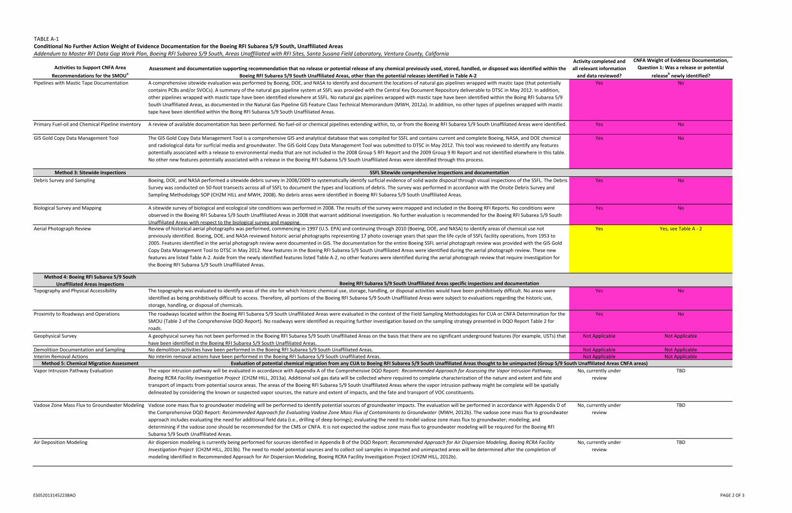
TABLE A‐1Conditional No Further Action Weight of Evidence Documentation for the Boeing RFI Subarea 5/9 South, Unaffiliated Areas Addendum to Master RFI Data Gap Work Plan, Boeing RFI Subarea 5/9 South, Areas Unaffiliated with RFI Sites, Santa Susana Field Laboratory, Ventura County, California
Activities to Support CNFA Area
Recommendations for the SMOUa
Assessment and documentation supporting recommendation that no release or potential release of any chemical previously used, stored, handled, or disposed was identified within the
Boeing RFI Subarea 5/9 South Unaffiliated Areas, other than the potential releases identified in Table A‐2
Activity completed and
all relevant information
and data reviewed?
CNFA Weight of Evidence Documentation,
Question 1: Was a release or potential
releasebnewly identified?
Pipelines with Mastic Tape Documentation A comprehensive sitewide evaluation was performed by Boeing, DOE, and NASA to identify and document the locations of natural gas pipelines wrapped with mastic tape (that potentially
contains PCBs and/or SVOCs). A summary of the natural gas pipeline system at SSFL was provided with the Central Key Document Repository deliverable to DTSC in May 2012. In addition,
other pipelines wrapped with mastic tape have been identified elsewhere at SSFL. No natural gas pipelines wrapped with mastic tape have been identified within the Boing RFI Subarea 5/9
South Unaffiliated Areas, as documented in the Natural Gas Pipeline GIS Feature Class Technical Memorandum (MWH, 2012a). In addition, no other types of pipelines wrapped with mastic
tape have been identified within the Boing RFI Subarea 5/9 South Unaffiliated Areas.
Yes No
Primary Fuel‐oil and Chemical Pipeline inventory A review of available documentation has been performed. No fuel‐oil or chemical pipelines extending within, to, or from the Boeing RFI Subarea 5/9 South Unaffiliated Areas were identified. Yes No
GIS Gold Copy Data Management Tool The GIS Gold Copy Data Management Tool is a comprehensive GIS and analytical database that was compiled for SSFL and contains current and complete Boeing, NASA, and DOE chemical
and radiological data for surficial media and groundwater. The GIS Gold Copy Data Management Tool was submitted to DTSC in May 2012. This tool was reviewed to identify any features
potentially associated with a release to environmental media that are not included in the 2008 Group 5 RFI Report and the 2009 Group 9 RI Report and not identified elsewhere in this table.
No other new features potentially associated with a release in the Boeing RFI Subarea 5/9 South Unaffiliated Areas were identified through this process.
Yes No
Method 3: Sitewide Inspections
Debris Survey and Sampling Boeing, DOE, and NASA performed a sitewide debris survey in 2008/2009 to systematically identify surficial evidence of solid waste disposal through visual inspections of the SSFL. The Debris
Survey was conducted on 50‐foot transects across all of SSFL to document the types and locations of debris. The survey was performed in accordance with the Onsite Debris Survey and
Sampling Methodology SOP (CH2M HILL and MWH, 2008). No debris areas were identified in Boeing RFI Subarea 5/9 South Unaffiliated Areas.
Yes No
Biological Survey and Mapping A sitewide survey of biological and ecological site conditions was performed in 2008. The results of the survey were mapped and included in the Boeing RFI Reports. No conditions were
observed in the Boeing RFI Subarea 5/9 South Unaffiliated Areas in 2008 that warrant additional investigation. No further evaluation is recommended for the Boeing RFI Subarea 5/9 South
Unaffiliated Areas with respect to the biological survey and mapping.
Yes No
Aerial Photograph Review Review of historical aerial photographs was performed, commencing in 1997 (U.S. EPA) and continuing through 2010 (Boeing, DOE, and NASA) to identify areas of chemical use not
previously identified. Boeing, DOE, and NASA reviewed historic aerial photographs representing 17 photo coverage years that span the life cycle of SSFL facility operations, from 1953 to
2005. Features identified in the aerial photograph review were documented in GIS. The documentation for the entire Boeing SSFL aerial photograph review was provided with the GIS Gold
Copy Data Management Tool to DTSC in May 2012. New features in the Boeing RFI Subarea 5/9 South Unaffiliated Areas were identified during the aerial photograph review. These new
features are listed Table A‐2. Aside from the newly identified features listed Table A‐2, no other features were identified during the aerial photograph review that require investigation for
the Boeing RFI Subarea 5/9 South Unaffiliated Areas.
Yes Yes, see Table A ‐ 2
Method 4: Boeing RFI Subarea 5/9 South
Unaffiliated Areas InspectionsTopography and Physical Accessibility The topography was evaluated to identify areas of the site for which historic chemical use, storage, handling, or disposal activities would have been prohibitively difficult. No areas were
identified as being prohibitively difficult to access. Therefore, all portions of the Boeing RFI Subarea 5/9 South Unaffiliated Areas were subject to evaluations regarding the historic use,
storage, handling, or disposal of chemicals.
Yes No
Proximity to Roadways and Operations The roadways located within the Boeing RFI Subarea 5/9 South Unaffiliated Areas were evaluated in the context of the Field Sampling Methodologies for CUA or CNFA Determination for the
SMOU (Table 2 of the Comprehensive DQO Report). No roadways were identified as requiring further investigation based on the sampling strategy presented in DQO Report Table 2 for
roads.
Yes No
Geophysical Survey A geophysical survey has not been performed in the Boeing RFI Subarea 5/9 South Unaffiliated Areas on the basis that there are no significant underground features (for example, USTs) that
have been identified in the Boeing RFI Subarea 5/9 South Unaffiliated Areas.
Not Applicable Not Applicable
Demolition Documentation and Sampling No demolition activities have been performed in the Boeing RFI Subarea 5/9 South Unaffiliated Areas. Not Applicable Not Applicable
Interim Removal Actions No interim removal actions have been performed in the Boeing RFI Subarea 5/9 South Unaffiliated Areas. Not Applicable Not Applicable
Method 5: Chemical Migration Assessment
Vapor Intrusion Pathway Evaluation The vapor intrusion pathway will be evaluated in accordance with Appendix A of the Comprehensive DQO Report: Recommended Approach for Assessing the Vapor Intrusion Pathway,
Boeing RCRA Facility Investigation Project (CH2M HILL, 2013a). Additional soil gas data will be collected where required to complete characterization of the nature and extent and fate and
transport of impacts from potential source areas. The areas of the Boeing RFI Subarea 5/9 South Unaffiliated Areas where the vapor intrusion pathway might be complete will be spatially
delineated by considering the known or suspected vapor sources, the nature and extent of impacts, and the fate and transport of VOC constituents.
No, currently under
review
TBD
Vadose Zone Mass Flux to Groundwater Modeling Vadose zone mass flux to groundwater modeling will be performed to identify potential sources of groundwater impacts. The evaluation will be performed in accordance with Appendix D of
the Comprehensive DQO Report: Recommended Approach for Evaluating Vadose Zone Mass Flux of Contaminants to Groundwater (MWH, 2012b). The vadose zone mass flux to groundwater
approach includes evaluating the need for additional field data (i.e., drilling of deep borings); evaluating the need to model vadose zone mass flux to groundwater; modeling; and
determining if the vadose zone should be recommended for the CMS or CNFA. It is not expected the vadose zone mass flux to groundwater modeling will be required for the Boeing RFI
Subarea 5/9 South Unaffiliated Areas.
No, currently under
review
TBD
Air Deposition Modeling Air dispersion modeling is currently being performed for sources identified in Appendix B of the DQO Report: Recommended Approach for Air Dispersion Modeling, Boeing RCRA Facility
Investigation Project (CH2M HILL, 2013b). The need to model potential sources and to collect soil samples in impacted and unimpacted areas will be determined after the completion of
modeling identified in Recommended Approach for Air Dispersion Modeling, Boeing RCRA Facility Investigation Project (CH2M HILL, 2012b).
No, currently under
review
TBD
SSFL Sitewide comprehensive inspections and documentation
Boeing RFI Subarea 5/9 South Unaffiliated Areas specific inspections and documentation
Evaluation of potential chemical migration from any CUA to Boeing RFI Subarea 5/9 South Unaffiliated Areas thought to be unimpacted (Group 5/9 South Unaffiliated Areas CNFA areas)
ES052013145223BAO PAGE 2 OF 3
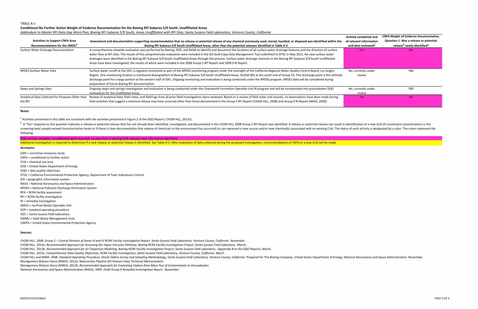
TABLE A‐1Conditional No Further Action Weight of Evidence Documentation for the Boeing RFI Subarea 5/9 South, Unaffiliated Areas Addendum to Master RFI Data Gap Work Plan, Boeing RFI Subarea 5/9 South, Areas Unaffiliated with RFI Sites, Santa Susana Field Laboratory, Ventura County, California
Activities to Support CNFA Area
Recommendations for the SMOUa
Assessment and documentation supporting recommendation that no release or potential release of any chemical previously used, stored, handled, or disposed was identified within the
Boeing RFI Subarea 5/9 South Unaffiliated Areas, other than the potential releases identified in Table A‐2
Activity completed and
all relevant information
and data reviewed?
CNFA Weight of Evidence Documentation,
Question 1: Was a release or potential
releasebnewly identified?
Surface Water Drainage Documentation A comprehensive sitewide evaluation was performed by Boeing, DOE, and NASA to identify and document the locations of all surface water drainage features and the direction of surface
water flow at RFI sites. The results of this comprehensive evaluation were included in the GIS Gold Copy Data Management Tool submitted to DTSC in May 2012. No new surface water
drainages were identified in the Boeing RFI Subarea 5/9 South Unaffiliated Areas through this process. Surface water drainage channels in the Boeing RFI Subarea 5/9 South Unaffiliated
Areas have been investigated, the results of which were included in the 2008 Group 5 RFI Report and 2009 9 RI Report.
Yes No
NPDES Surface Water Data Surface water runoff at the SSFL is regularly monitored as part of the NPDES monitoring program under the oversight of the California Regional Water Quality Control Board, Los Angles
Region. One monitoring location is monitored downgradient of Boeing RFI Subarea 5/9 South Unaffiliated Areas: Outfall 002 at the south end of Group 10. This discharge point is the ultimate
discharge point for a large portion of the western half of SSFL. Ongoing monitoring and evaluation is being conducted under the NPDES program. NPDES data will be considered during
preparation of future Boeing RFI documentation.
No, currently under
review
TBD
Seeps and Springs Data Ongoing seeps and springs investigation and evaluation is being conducted under the Chatsworth Formation Operable Unit RI program and will be incorporated into groundwater DQO
evaluations for the Unaffiliated Areas.
No, currently under
review
TBD
Analytical Data Collected for Purposes Other than
the RFI
Review of analytical data, field notes, and field logs from all prior field investigations were reviewed. Based on a review of field notes and records, no observations have been made during
field activities that suggest a chemical release may have occurred other than those documented in the Group 5 RFI Report (CH2M HILL, 2008) and Group 9 RI Report (NASA, 2009).
Yes No
Notes:
DQO activity complete, no additional work required, no new CUA or existing CUA‐relevant new information identified.
Sources:
CH2M HILL. 2008. Group 5 – Central Portions of Areas III and IV RCRA Facility Investigation Report, Santa Susana Field Laboratory, Ventura County, California. November.
CH2M HILL. 2013a. Recommended Approach for Assessing the Vapor Intrusion Pathway, Boeing RCRA Facility Investigation Project, Santa Susana Field Laboratory . March.
CH2M HILL. 2013b. Recommended Approach for Air Dispersion Modeling, Boeing RCRA Facility Investigation Project, Santa Susana Field Laboratory . (Appendix B to the DQO Report). March.
CH2M HILL. 2013c. Comprehensive Data Quality Objectives, RCRA Facility Investigation, Santa Susana Field Laboratory, Ventura County, California. March.
CH2M HILL and MWH. 2008. Standard Operating Procedure, Onsite Debris Survey and Sampling Methodology, Santa Susana Field Laboratory, Ventura County, California. Prepared for The Boeing Company, United States Department of Energy, National Aeronautics and Space Administration. November.
Montgomery Watson Harza (MWH). 2012a. Natural Gas Pipeline GIS Feature Class Technical Memorandum.
Montgomery Watson Harza (MWH). 2012b. Recommended Approach for Evaluating Vadose Zone Mass Flux of Contaminants to Groundwater.
National Aeronautics and Space Administration (NASA). 2009. Draft Group 9 Remedial Investigation Report . November.
Acronyms:
CMS = corrective measures study
CNFA = conditional no further action
CUA = chemical use area
DOE = United States Department of Energy
DQO = data quality objectives
DTSC = California Environmental Protection Agency, Department of Toxic Substances Control
GIS = geographic information system
NASA = National Aeronautics and Space Administration
NPDES = National Pollutant Discharge Elimination System
RFA = RCRA facility assessment
RFI = RCRA facility investigation
RI = remedial investigation
SMOU = Surficial Media Operable Unit
SOP = standard operating procedure
SSFL = Santa Susana Field Laboratory
SWMU = Solid Waste Management Units
USEPA = United States Environmental Protection Agency
a Activities presented in this table are consistent with the activities presented in Figure 2 of the DQO Report ( CH2M HILL, 2013c).b A "Yes" response to this question indicates a release or potential release that has not already been identified, investigated, and documented in the CH2M HILL 2008 Group 5 RFI Report was identified. A release or potential release can result in identification of a new CUA (if constituent concentrations in the
screening‐level sample exceed characterization levels or if there is clear documentation that release of chemicals to the environment has occurred) or can represent a new source and/or new chemical(s) associated with an existing CUA. The status of each activity is designated by a color. The colors represent the
following:
Additional investigation is required to determine if a new release or potential release is identified. See Table A‐2. After evaluation of data collected during the proposed investigation, recommendations of CNFA or a new CUA will be made.
ES052013145223BAO PAGE 3 OF 3
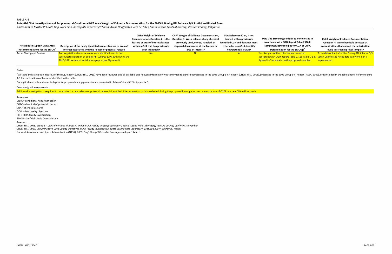
TABLE A‐2
Potential CUA Investigation and Supplemental Conditional NFA Area Weight of Evidence Documentation for the SMOU, Boeing RFI Subarea 5/9 South Unaffiliated Areas
Addendum to Master RFI Data Gap Work Plan, Boeing RFI Subarea 5/9 South, Areas Unaffiliated with RFI Sites, Santa Susana Field Laboratory, Ventura County, California
Activities to Support CNFA Area
Recommendations for the SMOUa
Description of the newly identified suspect feature or area of
interest associated with the release or potential release
CNFA Weight of Evidence
Documentation, Question 2: Is the
feature or area of interest located
within a CUA that has previously
been identified?
CNFA Weight of Evidence Documentation,
Question 3: Was a release of any chemical
previously used, stored, handled, or
disposed documented at the feature or
area of interest?
CUA Reference ID or, if not
located within previously
identified CUA and does not meet
criteria for new CUA, identify
new potential CUA ID
Data Gap Screening Samples to be collected in
accordance with DQO Report Table 2 (Field
Sampling Methodologies for CUA or CNFA
Determination for the SMOU)?b
CNFA Weight of Evidence Documentation,
Question 4: Were chemicals detected at
concentrations that exceed characterization
levels in screening‐level samples?
Aerial Photograph Review Two vegetation clearance areas were identified near in the
southwestern portion of Boeing RFI Subarea 5/9 South during the
2010/2011 review of aerial photographs (see Figure A‐1).
No No A Yes. Samples will be collected and analyzed
consistent with DQO Report Table 2. See Table C‐1 in
Appendix C for details on the proposed samples.
To be determined after the Boeing RFI Subarea 5/9
South Unaffiliated Areas data gap work plan is
implemented.
Notes:
b Analytical methods and sample depths for proposed data gap samples are presented in Tables C‐1 and C‐2 in Appendix C.
Color designation represents:
Acronyms:
Sources:
CH2M HILL. 2008. Group 5 – Central Portions of Areas III and IV RCRA Facility Investigation Report, Santa Susana Field Laboratory, Ventura County, California. November.CH2M HILL. 2013. Comprehensive Data Quality Objectives, RCRA Facility Investigation, Santa Susana Field Laboratory, Ventura County, California. March.
National Aeronautics and Space Administration (NASA). 2009. Draft Group 9 Remedial Investigation Report . March.
a All tasks and activities in Figure 2 of the DQO Report (CH2M HILL, 2013) have been reviewed and all available and relevant information was confirmed to either be presented in the 2008 Group 5 RFI Report (CH2M HILL, 2008), presented in the 2009 Group 9 RI Report (NASA, 2009), or is included in the table above. Refer to Figure
A‐1 for the locations of features identified in this table.
CNFA = conditional no further action
COPC = chemical of potential concern
CUA = chemical use area
DQO = data quality objective
RFI = RCRA facility investigation
SMOU = Surficial Media Operable Unit
Additional investigation is required to determine if a new release or potential release is identified. After evaluation of data collected during the proposed investigation, recommendations of CNFA or a new CUA will be made.
ES052013145223BAO PAGE 1 OF 1
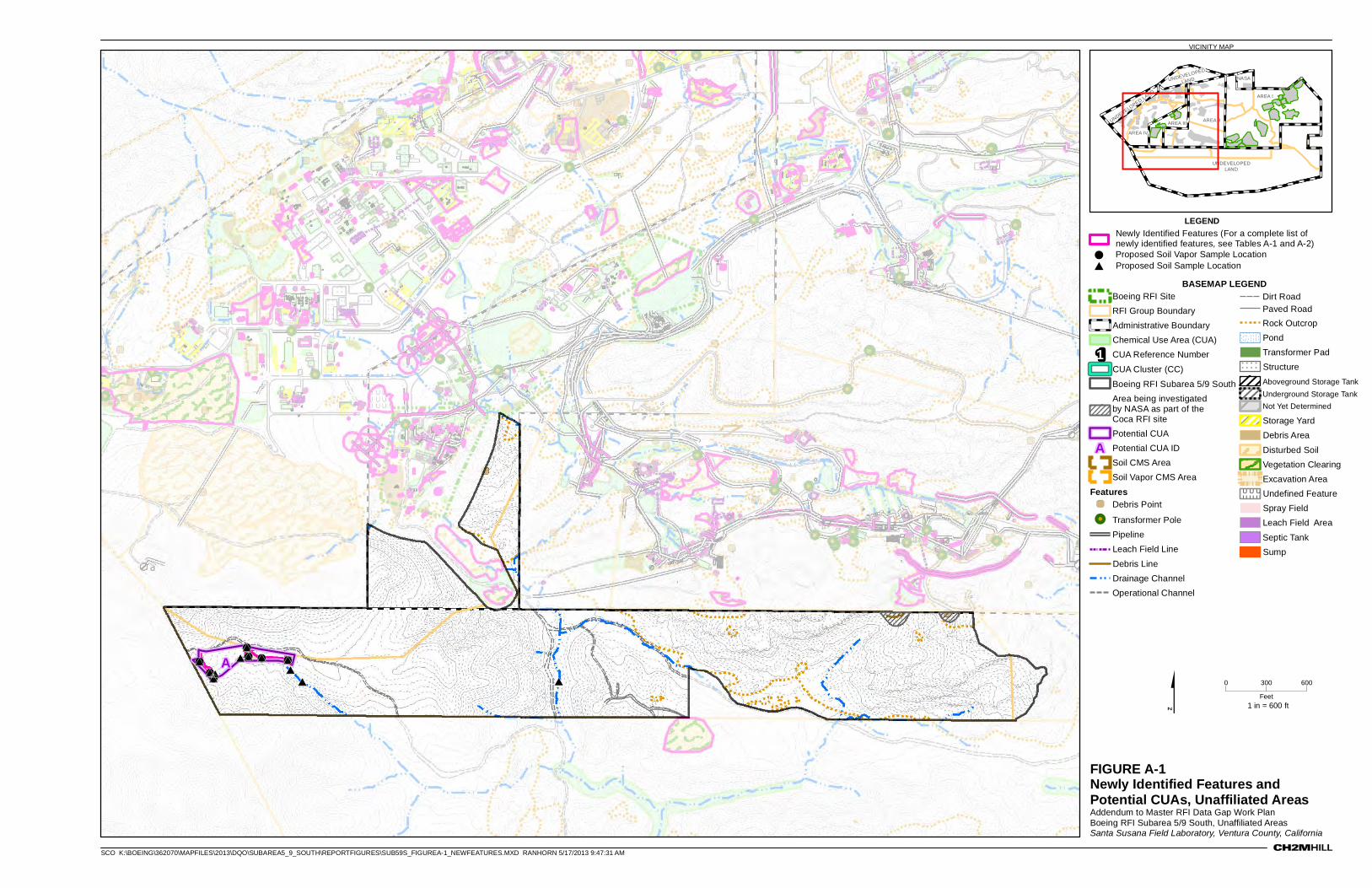
FIGURE A-1Newly Identified Features and Potential CUAs, Unaffiliated AreasAddendum to Master RFI Data Gap Work PlanBoeing RFI Subarea 5/9 South, Unaffiliated AreasSanta Susana Field Laboratory, Ventura County, California
VICINITY MAP
###
### # #
## #
#
!!!
!! ! !(
((
(( ( (*
**
*** * *
** *
*
A0 600300
Feet
BASEMAP LEGENDBoeing RFI Site
RFI Group Boundary
Administrative Boundary
Chemical Use Area (CUA)1 CUA Reference Number
CUA Cluster (CC)
Boeing RFI Subarea 5/9 South
Area being investigated by NASA as part of the Coca RFI site
Potential CUAA Potential CUA ID
Soil CMS Area
Soil Vapor CMS Area
Features' Debris Point
!! Transformer Pole
Pipeline
Leach Field Line
Debris Line
Drainage Channel
Operational Channel
Dirt RoadPaved Road
Rock Outcrop
Pond
Transformer Pad
! ! ! ! ! !
! ! ! ! ! !
! ! ! ! ! !
Structure
Aboveground Storage Tank
Underground Storage Tank
Not Yet Determined
Storage Yard
Debris Area
Disturbed Soil
Vegetation Clearing
Excavation Area
U U U UU U U UU U U U Undefined Feature
Spray Field
Leach Field Area
Septic Tank
Sump
NASA
AREA I
AREA II
AREA IV
AREA III
UNDEVELOPEDLAND
UNDEVELOPED
LAND
UNDEVELOPED LAND
$ 1 in = 600 ft
SCO K:\BOEING\362070\MAPFILES\2013\DQO\SUBAREA5_9_SOUTH\REPORTFIGURES\SUB59S_FIGUREA-1_NEWFEATURES.MXD RANHORN 5/17/2013 9:47:31 AM
LEGENDNewly Identified Features (For a complete list of newly identified features, see Tables A-1 and A-2)
! Proposed Soil Vapor Sample Location
# Proposed Soil Sample Location
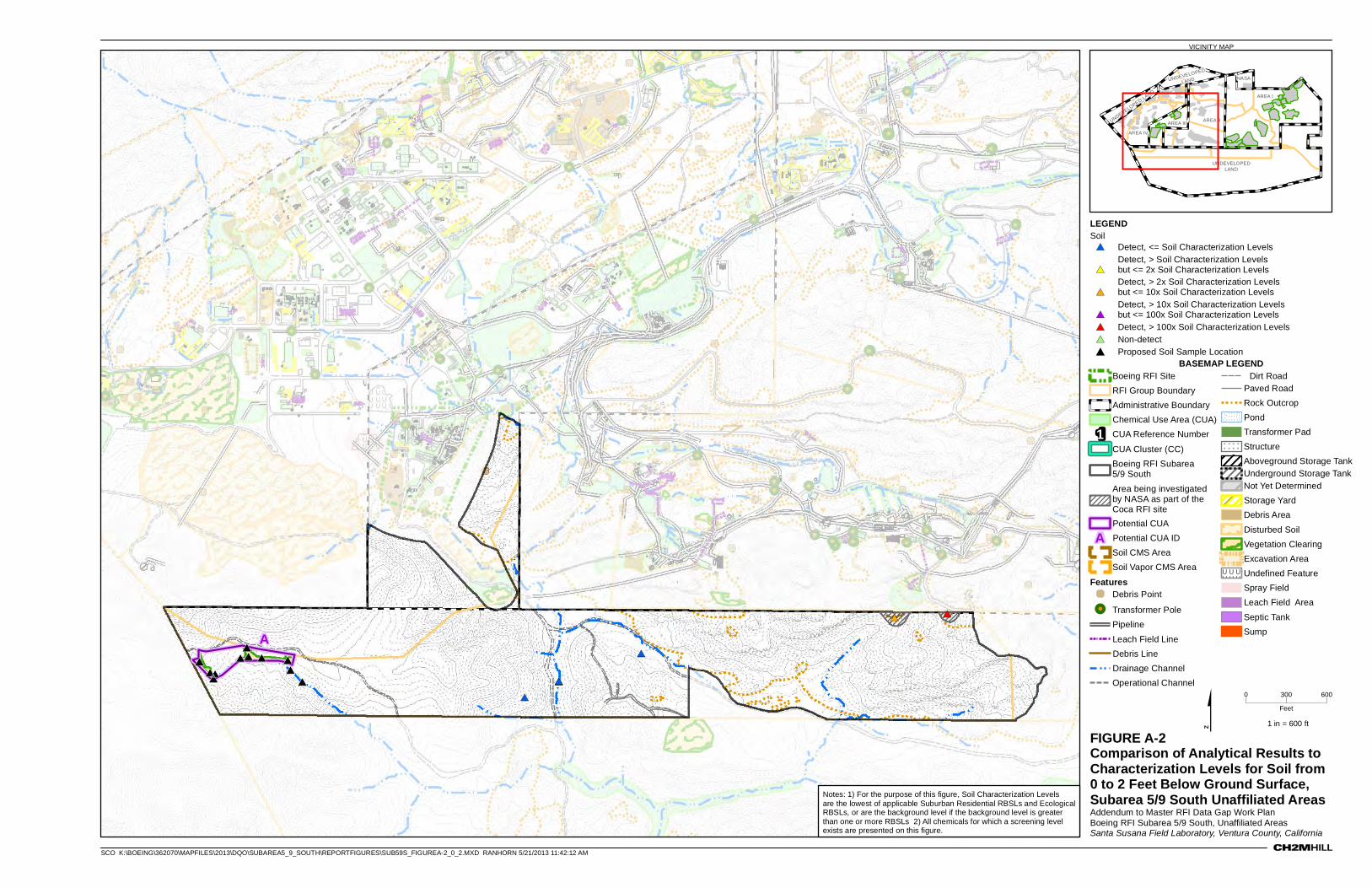
FIGURE A-2Comparison of Analytical Results to Characterization Levels for Soil from 0 to 2 Feet Below Ground Surface, Subarea 5/9 South Unaffiliated AreasAddendum to Master RFI Data Gap Work PlanBoeing RFI Subarea 5/9 South, Unaffiliated AreasSanta Susana Field Laboratory, Ventura County, California
VICINITY MAP
###
### # #
## #
#
***
*** * *
** *
*#
#
#
*
*
*
#* #*
A
0 600300
Feet
BASEMAP LEGENDBoeing RFI Site
RFI Group Boundary
Administrative Boundary
Chemical Use Area (CUA)1 CUA Reference Number
CUA Cluster (CC)
Boeing RFI Subarea 5/9 South
Area being investigated by NASA as part of the Coca RFI site
Potential CUAA Potential CUA ID
Soil CMS Area
Soil Vapor CMS Area
Features' Debris Point
!! Transformer Pole
Pipeline
Leach Field Line
Debris Line
Drainage Channel
Operational Channel
Dirt RoadPaved Road
Rock Outcrop
Pond
Transformer Pad
! ! ! ! ! !
! ! ! ! ! !
! ! ! ! ! !Structure
Aboveground Storage TankUnderground Storage TankNot Yet Determined
Storage Yard
Debris Area
Disturbed Soil
Vegetation Clearing
Excavation Area
U U U U UU U U U UU U U U U
Undefined Feature
Spray Field
Leach Field Area
Septic Tank
Sump
NASA
AREA I
AREA II
AREA IV
AREA III
UNDEVELOPEDLAND
UNDEVELOPED
LAND
UNDEVELOPED LAND
$ 1 in = 600 ft
SCO K:\BOEING\362070\MAPFILES\2013\DQO\SUBAREA5_9_SOUTH\REPORTFIGURES\SUB59S_FIGUREA-2_0_2.MXD RANHORN 5/21/2013 11:42:12 AM
LEGENDSoil#* Detect, <= Soil Characterization Levels
#*Detect, > Soil Characterization Levels but <= 2x Soil Characterization Levels
#*Detect, > 2x Soil Characterization Levels but <= 10x Soil Characterization Levels
#*Detect, > 10x Soil Characterization Levels but <= 100x Soil Characterization Levels
#* Detect, > 100x Soil Characterization Levels
#* Non-detect
# Proposed Soil Sample Location
Notes: 1) For the purpose of this figure, Soil Characterization Levels are the lowest of applicable Suburban Residential RBSLs and Ecological RBSLs, or are the background level if the background level is greater than one or more RBSLs 2) All chemicals for which a screening level exists are presented on this figure.
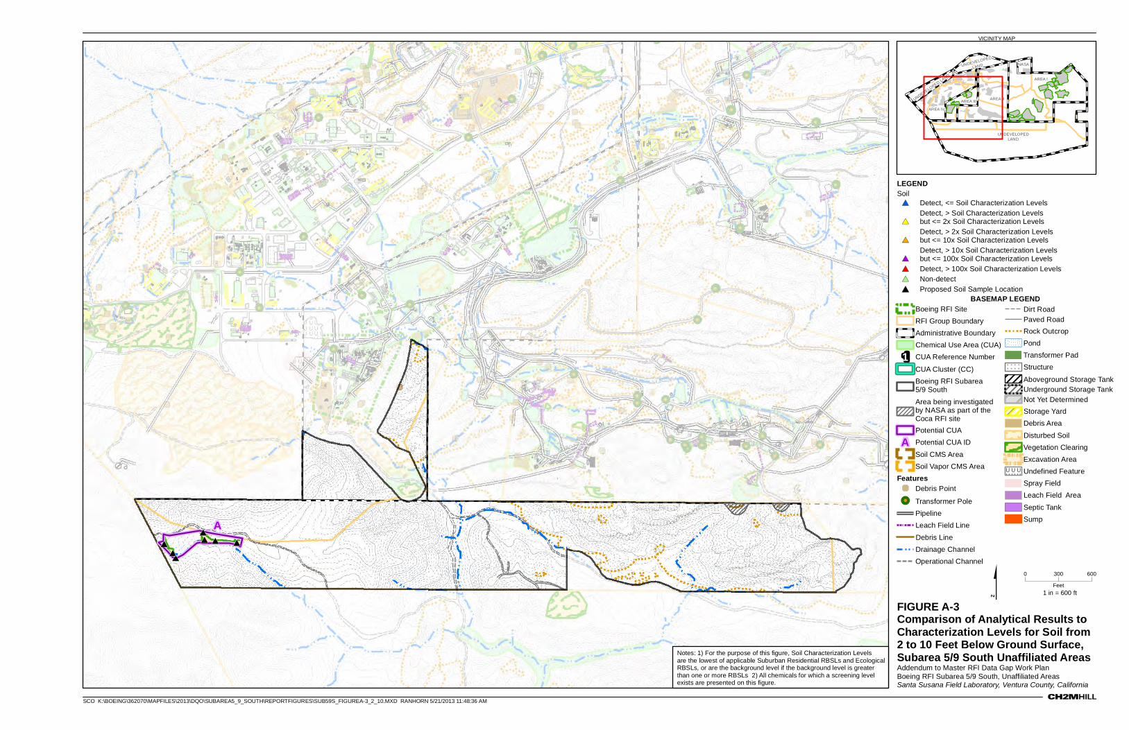
FIGURE A-3Comparison of Analytical Results to Characterization Levels for Soil from 2 to 10 Feet Below Ground Surface, Subarea 5/9 South Unaffiliated AreasAddendum to Master RFI Data Gap Work PlanBoeing RFI Subarea 5/9 South, Unaffiliated AreasSanta Susana Field Laboratory, Ventura County, California
VICINITY MAP
###
## # #*
**
** * *
RFI Group4
RFI Group3
A
0 600300
Feet
BASEMAP LEGENDBoeing RFI Site
RFI Group Boundary
Administrative Boundary
Chemical Use Area (CUA)1 CUA Reference Number
CUA Cluster (CC)
Boeing RFI Subarea 5/9 South
Area being investigated by NASA as part of the Coca RFI site
Potential CUAA Potential CUA ID
Soil CMS Area
Soil Vapor CMS Area
Features' Debris Point
!! Transformer Pole
Pipeline
Leach Field Line
Debris Line
Drainage Channel
Operational Channel
Dirt RoadPaved Road
Rock Outcrop
Pond
Transformer Pad
! ! ! ! !
! ! ! ! !
! ! ! ! ! Structure
Aboveground Storage TankUnderground Storage TankNot Yet Determined
Storage Yard
Debris Area
Disturbed Soil
Vegetation Clearing
Excavation Area
U U U UU U U UU U U U
Undefined Feature
Spray Field
Leach Field Area
Septic Tank
Sump
NASA
AREA I
AREA II
AREA IV
AREA III
UNDEVELOPEDLAND
UNDEVELOPED
LAND
UNDEVELOPED LAND
$ 1 in = 600 ft
SCO K:\BOEING\362070\MAPFILES\2013\DQO\SUBAREA5_9_SOUTH\REPORTFIGURES\SUB59S_FIGUREA-3_2_10.MXD RANHORN 5/21/2013 11:48:36 AM
LEGENDSoil#* Detect, <= Soil Characterization Levels
#*Detect, > Soil Characterization Levels but <= 2x Soil Characterization Levels
#*Detect, > 2x Soil Characterization Levels but <= 10x Soil Characterization Levels
#*Detect, > 10x Soil Characterization Levels but <= 100x Soil Characterization Levels
#* Detect, > 100x Soil Characterization Levels
#* Non-detect
# Proposed Soil Sample Location
Notes: 1) For the purpose of this figure, Soil Characterization Levels are the lowest of applicable Suburban Residential RBSLs and Ecological RBSLs, or are the background level if the background level is greater than one or more RBSLs 2) All chemicals for which a screening level exists are presented on this figure.
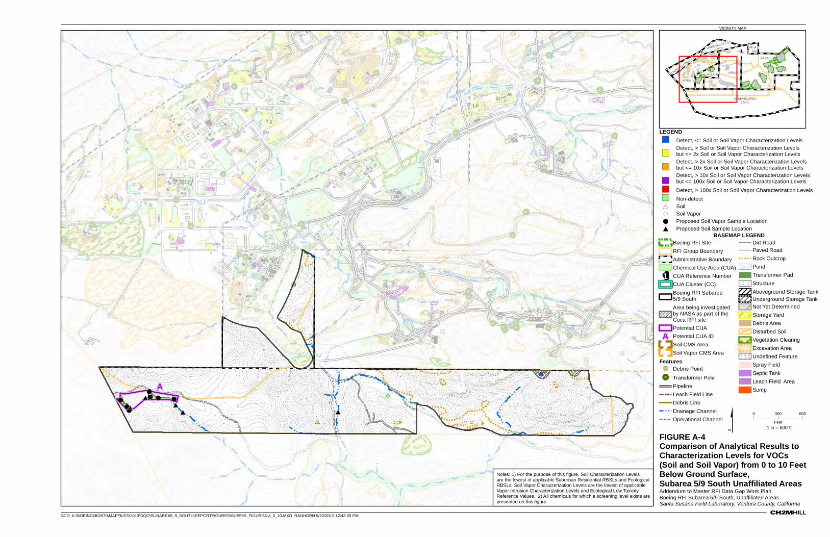
FIGURE A-4Comparison of Analytical Results to Characterization Levels for VOCs (Soil and Soil Vapor) from 0 to 10 Feet Below Ground Surface, Subarea 5/9 South Unaffiliated AreasAddendum to Master RFI Data Gap Work PlanBoeing RFI Subarea 5/9 South, Unaffiliated AreasSanta Susana Field Laboratory, Ventura County, California
VICINITY MAP
#
#
#
#
*
*
*
*#*
#
## #
#
!!!
!! ! !(
((
(( ( (*
** *
*
CTL-V
Area I Burn Pit
RFI Group4
RFI Group3
A
0 600300
Feet
BASEMAP LEGENDBoeing RFI Site
RFI Group Boundary
Administrative Boundary
Chemical Use Area (CUA)1 CUA Reference Number
CUA Cluster (CC)
Boeing RFI Subarea 5/9 South
Area being investigated by NASA as part of the Coca RFI site
Potential CUAA Potential CUA ID
Soil CMS Area
Soil Vapor CMS Area
Features' Debris Point
!! Transformer Pole
Pipeline
Leach Field Line
Debris Line
Drainage Channel
Operational Channel
Dirt RoadPaved Road
Rock Outcrop
Pond
Transformer Pad
! ! ! ! ! !
! ! ! ! ! !
! ! ! ! ! !Structure
Aboveground Storage TankUnderground Storage TankNot Yet Determined
Storage Yard
Debris Area
Disturbed Soil
Vegetation Clearing
Excavation Area
U U U U UU U U U UU U U U UUndefined Feature
Spray Field
Septic Tank
Leach Field Area
Sump
NASA
AREA I
AREA II
AREA IV
AREA III
UNDEVELOPEDLAND
UNDEVELOPED
LAND
UNDEVELOPED LAND
$ 1 in = 600 ft
SCO K:\BOEING\362070\MAPFILES\2013\DQO\SUBAREA5_9_SOUTH\REPORTFIGURES\SUB59S_FIGUREA-4_0_10.MXD RANHORN 5/22/2013 12:43:35 PM
LEGEND") Detect, <= Soil or Soil Vapor Characterization Levels
")Detect, > Soil or Soil Vapor Characterization Levels but <= 2x Soil or Soil Vapor Characterization Levels
")Detect, > 2x Soil or Soil Vapor Characterization Levels but <= 10x Soil or Soil Vapor Characterization Levels
")Detect, > 10x Soil or Soil Vapor Characterization Levelsbut <= 100x Soil or Soil Vapor Characterization Levels
") Detect, > 100x Soil or Soil Vapor Characterization Levels
") Non-detect
* Soil
( Soil Vapor
! Proposed Soil Vapor Sample Location
# Proposed Soil Sample Location
Notes: 1) For the purpose of this figure, Soil Characterization Levels are the lowest of applicable Suburban Residential RBSLs and Ecological RBSLs; Soil Vapor Characterization Levels are the lowest of applicable Vapor Intrusion Characterization Levels and Ecological Low Toxicity Reference Values. 2) All chemicals for which a screening level exists are presented on this figure.
Appendix B Responses to DTSC Comments Relevant to the
Unaffiliated Areas
SFO\131410001 B-1 ES052013145223BAO
COPYRIGHT 2013 BY CH2M HILL, INC.
Appendix B Contents No comments have been received to date that specifically relate to the Boeing RFI Subarea 5/9 South Unaffiliated Areas.
Appendix C Unaffiliated Areas Data Gap Sampling and Analysis Plan
COPYRIGHT 2013 BY CH2M HILL, INC.
Unaffiliated Areas Data Gap Sampling and Analysis Plan,
Santa Susana Field Laboratory, Ventura County, California
Prepared for The Boeing Company
May 2013
Prepared by
Contents Section Page
SFO\131410004 iii ES052013145223BAO
COPYRIGHT 2013 BY CH2M HILL, INC.
Acronyms and Abbreviations ............................................................................................................................... v
1.0 Introduction ............................................................................................................................................ 1
2.0 Summary of Proposed Samples for the Unaffiliated Areas....................................................................... 1
3.0 Field Sampling Procedures ...................................................................................................................... 1 3.1 Sampling Guidelines ............................................................................................................................ 2
3.1.1 Soil .......................................................................................................................................... 2 3.1.2 Soil Vapor ................................................................................................................................ 2
4.0 Analytical Guidelines .............................................................................................................................. 2 4.1 Criteria for Contingent Analyses .......................................................................................................... 3 4.2 Criteria for Contingent Samples .......................................................................................................... 3
5.0 Quality Assurance/Quality Control Sampling Requirements .................................................................... 3
6.0 Step‐out and Step‐down Samples ........................................................................................................... 4
7.0 References .............................................................................................................................................. 4
Tables
C‐1 Boeing RFI Subarea 5/9 South Unaffiliated Areas ‐ Proposed Data Gap Sampling and Analysis C‐2 Unaffiliated Areas Soil and Soil Vapor Analyses
Figure
C‐1 Proposed Sample Locations for the Subarea 5/9 South Unaffiliated Areas
SFO\131410004 v ES052013145223BAO
COPYRIGHT 2013 BY CH2M HILL, INC.
Acronyms and Abbreviations bgs below ground surface
DQO data quality objective
DTSC California Environmental Protection Agency, Department of Toxic Substances Control
MRL method reporting limit
QA/QC quality assurance/quality control
QAPP Quality Assurance Project Plan
RCRA Resource Conservation and Recovery Act
RFI RCRA facility investigation
SAP sampling and analysis plan
SOP standard operating procedure
SSFL Santa Susana Field Laboratory
Unaffiliated Areas Subarea 5/9 South Areas Unaffiliated with RFI Sites
VOC volatile organic compound
SFO\131410004 1 ES052013145223BAO
COPYRIGHT 2013 BY CH2M HILL, INC.
Unaffiliated Areas Data Gap Sampling and Analysis Plan, Santa Susana Field Laboratory, Ventura County, California
1.0 Introduction This document presents the data gap sampling and analysis plan (SAP) for the areas not affiliated with Resource Conservation and Recovery Act (RCRA) facility investigation (RFI) sites in Boeing RFI Subarea 5/9 South at the Santa Susana Field Laboratory (SSFL) in Ventura County, California. The purpose of this SAP is to present the plan for addressing data gaps identified within the Boeing RFI Subarea 5/9 South Areas Unaffiliated with RFI Sites (Unaffiliated Areas) through the comprehensive data quality objective (DQO) evaluation. The data gaps identified for the Unaffiliated Areas are presented in the Addendum to Master Resource Conservation and Recovery Act Facility Investigation Data Gap Work Plan, Boeing RFI Subarea 5/9 South, Areas Unaffiliated with RFI Sites, Santa Susana Field Laboratory, Ventura County, California (Master RFI Data Gap Work Plan) (CH2M HILL, 2013a). The SAP presented herein describes how and where data will be collected to address the data gaps identified within the Unaffiliated Areas.
2.0 Summary of Proposed Samples for the Unaffiliated Areas Table C‐1 presents the sample media, sample depth, and analytes for each sample proposed for collection within the Unaffiliated Areas. In addition, Table C‐1 presents the rationale and the specific DQOs that each proposed sample are intended to satisfy. Table C‐2 presents the laboratory analytical methods proposed for the analytes listed in Table C‐1. Figure C‐1 presents the locations of the proposed samples. The proposed samples presented in Table C‐1 and on Figure C‐1 were identified based on the characterization sampling and analysis strategy presented in the Comprehensive Data Quality Objectives, RCRA Facility Investigation, Santa Susana Field Laboratory, Ventura County, California (DQO Report) (CH2M HILL, 2013b) for surface water bodies, soil and sediment, and the vadose zone.
Samples will be collected from the locations presented in Table C‐1 and Figure C‐1. However, field staff will field check proposed sample locations relative to site drainage patterns, surface slope, and topography and will use professional judgment to modify sample locations accordingly. In addition, field staff will field‐check proposed sample locations relative to existing structures, rock outcrops, above‐ and belowground utilities, or other obstacles and adjust the sample locations accordingly. The final locations of each sample will be recorded using handheld global positioning system equipment. Soil sample depths may also be adjusted from the depths shown in Table C‐1 based on observed staining, discoloration, or elevated volatile organic compound (VOC) levels recorded with a photoionization detector during drilling.
Sample location identifications were developed using the two‐digit code that indicates the RFI site associated with the sample (U5 [for samples within Group 5] and U9 [for samples within Group 9] were used for samples within the Unaffiliated Areas), followed by the two‐digit code that indicates the sample/matrix type (for example, BS was used for soil boring samples and SV was used for soil vapor samples), followed by four numerical digits (starting with “2000” at each site). For example, a sample numbered U5BS2002 would be a soil boring sample (BS) and is the third consecutively numbered sample (2002) collected at within Group 5 in the Unaffiliated Areas.
3.0 Field Sampling Procedures Samples will be collected in accordance with the SSFL standard operating procedures (SOPs) (Boeing, 2013), which were submitted to and approved by DTSC in March 2013. Prior to sample collection, sample locations will be cleared of vegetation, SSFL utility diagrams will be reviewed, sample locations will be staked, third‐party utility surveys will be performed, and DigAlert will be contacted. The sample locations may be adjusted based on
UNAFFILIATED AREAS DATA GAP SAMPLING AND ANALYSIS PLAN, SANTA SUSANA FIELD LABORATORY, VENTURA COUNTY, CALIFORNIA
2 SFO\131410004 ES052013145223BAO
COPYRIGHT 2013 BY CH2M HILL, INC.
information regarding subsurface utilities or other subsurface structures provided by the third‐party utility survey company and DigAlert. The final locations of each sample will be recorded using handheld global positioning system equipment.
3.1 Sampling Guidelines Samples will be collected in accordance with the DQO Report and field SOPs. However, additional guidelines for soil and soil vapor sample collection are outlined in Sections 3.1.1 and 3.1.2.
3.1.1 Soil In cases where all the planned soil samples at a specific location cannot be collected due to the presence of bedrock, a soil sample will be collected just above the depth where the rig encountered refusal. However, the soil sample will not be collected from the refusal depth if the following two criteria are satisfied:
A more shallow sample(s) was collected at the same location and
The bottom depth of the shallower sample(s) would be less than 2 feet above the top of the refusal depth sample.
In accordance with DQO Report Table 6, step‐out samples are typically collected at the same depth as the original sample with concentrations that exceed characterization levels. However, VOC step‐out soil samples will not be collected from a more shallow depth than 1.5 feet (bottom sample depth). For example, if the original sample that contained VOCs at concentrations that exceed the corresponding characterization levels was collected from 0.5 feet below ground surface (bgs), the step out sample for that location would be collected from 1.5 feet bgs.
3.1.2 Soil Vapor Soil vapor samples will be collected from a minimum depth of 5 feet bgs. In cases where a soil vapor sample cannot be collected from at least 5 feet bgs due to refusal on bedrock or inadequate air flow, a soil sample will be collected in lieu of the soil vapor sample and analyzed for VOCs. This soil sample will be collected to support an evaluation of the vapor intrusion pathway. The soil sample will be collected from the maximum depth possible at that location, but no shallower than 3 feet bgs. The soil sample will not be collected if refusal on bedrock is encountered shallower than 3 feet bgs. In addition, the soil sample will not be collected if previous soil samples collected from greater than 3 feet bgs at that location were analyzed for VOCs.
At locations where a soil vapor sample may be collected from a minimum depth of 5 feet bgs but deeper samples cannot be collected from the proposed sample depths due to the presence of bedrock, a soil vapor sample will be collected just above the depth where the rig encountered refusal. However, the soil vapor sample will not be collected from the refusal depth if the bottom depth of the shallower soil vapor sample(s) would be less than three feet above the top of the refusal depth soil vapor sample.
4.0 Analytical Guidelines Table C‐1 presents the chemicals that are proposed for analysis in each sample. Table C‐2 presents the analytical methods that are proposed for use during implementation of this SAP. The Surficial Media Operable Unit Quality Assurance Project Plan (QAPP) (MECx, 2012] presents the specific chemicals that will be analyzed and reported under each method. Soil samples will be homogenized by the analytical laboratories in accordance with Boeing SSFL SOP 21, Soil Sampling.
Analytical guidelines that were followed during preparation of this SAP include:
For features where the historical uses are not known (and therefore, the chemical uses are also unknown), a screening for total petroleum hydrocarbons, VOCs, semivolatile organic compounds, and metals will be performed. Soil at these features also might be analyzed for other chemical groups based on the chemical uses of adjacent features/RFI sites.
UNAFFILIATED AREAS DATA GAP SAMPLING AND ANALYSIS PLAN, SANTA SUSANA FIELD LABORATORY, VENTURA COUNTY, CALIFORNIA
SFO\131410004 3 ES052013145223BAO
COPYRIGHT 2013 BY CH2M HILL, INC.
4.1 Criteria for Contingent Analyses In some cases, the need for performing select analytical methods is contingent on the results of performing other analytical methods on a particular sample. In these cases, the laboratory will be notified to hold the sample for analysis of select constituents until CH2M HILL has the opportunity to review the results of other analyses performed on the sample. CH2M HILL will notify the laboratory if analysis for the held constituents is necessary based on these results (based on a comparison of the analytical results to characterization levels). Table C‐1 identifies the constituents that will be held for analysis by the laboratory pending the results of other analytical methods. Examples of contingent analyses include:
In accordance with DQO Report Table 2, for newly identified features for which VOCs are listed for analysis in soil and soil vapor, the VOCs in soil samples will only be collected if the VOCs in soil vapor sample cannot be collected (either due to refusal on bedrock at a depth more shallow than 5 feet bgs or due to poor air flow in the soil vapor probe).
4.2 Criteria for Contingent Samples In some cases, the need for collecting a sample is contingent on the analytical results of other samples. Table C‐1 identifies the samples that will be held for collection or analysis pending the analytical results of other samples. Examples of contingent samples include:
In cases where the 10‐foot‐bgs sample is collected in the field, lab analysis of that sample will sometimes be held by the lab until CH2M HILL provides direction to analyze the sample. CH2M HILL will evaluate the need for lab analysis based on the results of samples above the proposed sample (generally based on analytical data for the 6‐foot‐bgs sample). The 10‐foot‐bgs sample will generally be analyzed by the lab (following direction from CH2M HILL) if constituents are detected above characterization levels in the 6‐foot‐bgs sample. The need to analyze the 10‐foot‐bgs sample is also dependent on the site conceptual model.
In some cases, samples will be recollected to address previous method reporting limits (MRLs) that exceed characterization levels. One instance in which samples may be recollected to address elevated MRLs is for analytes with previous elevated MRLs that have never been detected in the reporting area. If an analyte was never detected in the reporting area, data for that analyte would generally not be included in the risk assessment for that reporting area. Therefore, greater assurance that the analyte is not present above characterization levels is desired. Soil and soil vapor samples are proposed for collection in Table C‐1 to address this uncertainty. However, if the specific analytes that have not been detected previously are detected in one or more of the other samples planned for collection, the samples proposed to address this issue will not be collected.
5.0 Quality Assurance/Quality Control Sampling Requirements Laboratory analysis will be performed in accordance with the QAPP (MECx, 2012). The QAPP describes the quality assurance/quality control (QA/QC) requirements for SSFL and identifies the analytical methods, method detection limits, and analyte lists for the constituents used at SSFL. In accordance with the QAPP, QA/QC samples will be collected and analyzed at the following frequency:
Field Duplicate: Collected on a 5 percent frequency for each matrix and for each type of analysis.
Laboratory Split: Collected on a 5 percent frequency for each matrix for each type of analysis. Split samples are analyzed by a laboratory other than the primary laboratory.
Matrix Spike/Matrix Spike Duplicate: Collected on a 5 percent frequency for each matrix and for each type of analysis.
Equipment Blanks: One sample collected per day for each equipment type that is decontaminated.
Trip Blank: One sample per cooler containing samples for analysis of VOCs.
UNAFFILIATED AREAS DATA GAP SAMPLING AND ANALYSIS PLAN, SANTA SUSANA FIELD LABORATORY, VENTURA COUNTY, CALIFORNIA
4 SFO\131410004 ES052013145223BAO
COPYRIGHT 2013 BY CH2M HILL, INC.
6.0 Step-out and Step-down Samples Following the collection of the proposed samples identified herein, the need to collect “step‐out” (to define lateral extent to required characterization levels) and “step‐down” (to define vertical extent to required characterization levels) samples will be assessed. If the samples proposed herein are found to contain constituents at concentrations that exceed the required characterization levels and the extents of the elevated concentrations are not defined by concentrations in existing samples, step‐out and step‐down samples will be collected using the characterization sampling and analysis strategy presented in the DQO Report (CH2M HILL, 2013b).
For soil and sediment, step‐down samples will be collected to the maximum depth possible using a hand auger or direct push rig. Step‐down samples will not be re‐attempted at locations that have previously been drilled to (and characterized at) the maximum depth that may be accessed with a hand auger or direct‐push rig. The vadose zone is addressed by DQO Report Table 8.
The results of all data gap sampling within the Unaffiliated Areas will be presented in a future data summary and findings report for Boeing RFI Subarea 5/9 South.
7.0 References The Boeing Company (Boeing). 2013. Standard Operating Procedures for Areas I and III of the Santa Susana Field
Laboratory, Ventura County, California. March.
CH2M HILL. 2008. Group 5 – Central Portions of Areas III and IV RCRA Facility Investigation Report, Santa Susana Field Laboratory, Ventura County, California. November.
CH2M HILL. 2013a. Addendum to Master RCRA Facility Investigation Data Gap Work Plan, Boeing RFI Subarea 5/9 South, Unaffiliated Areas, Santa Susana Field Laboratory, Ventura County, California. March.
CH2M HILL. 2013b. Comprehensive Data Quality Objectives, RCRA Facility Investigation, Santa Susana Field Laboratory, Ventura County, California. March.
MECx. 2012. Quality Assurance Project Plan, Santa Susana Field Laboratory (SSFL) RCRA Field Investigation, Surficial Media Operable Unit, Revision 5. November.
Tables
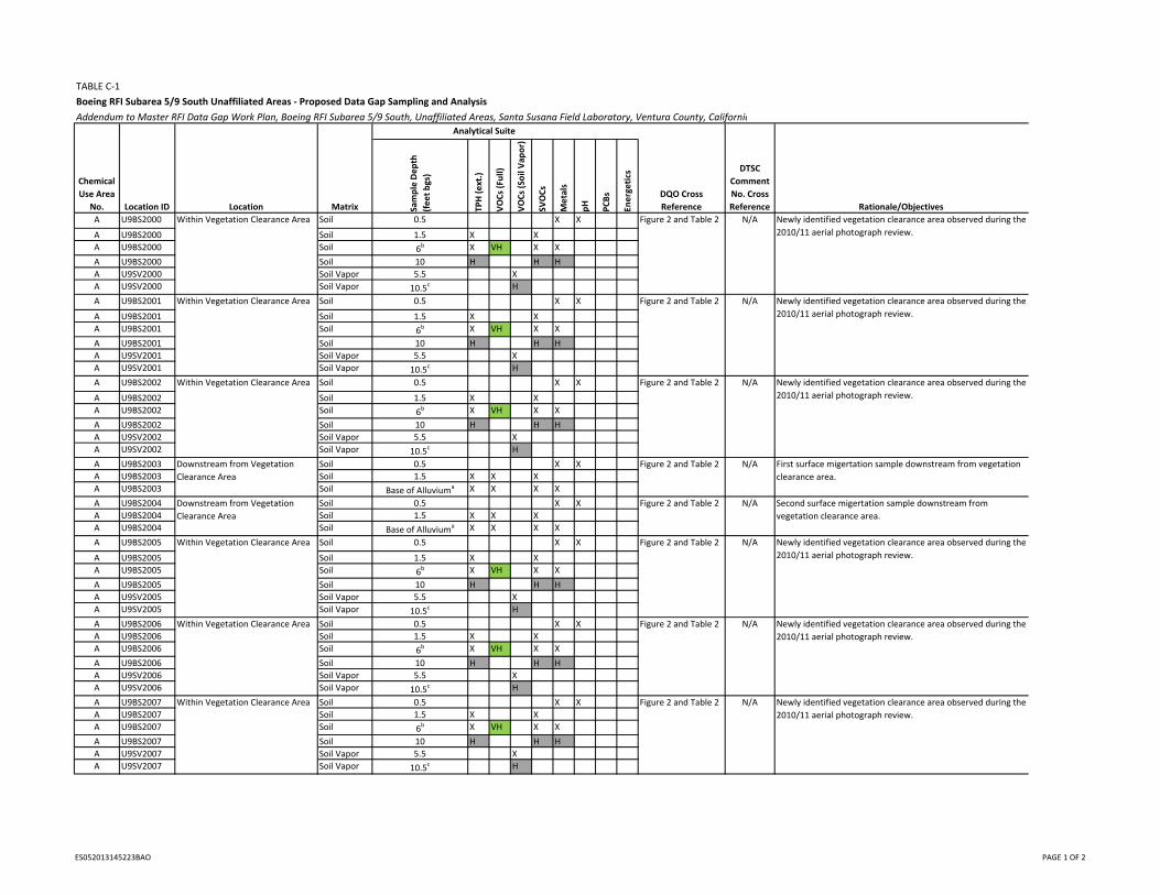
TABLE C‐1
Boeing RFI Subarea 5/9 South Unaffiliated Areas ‐ Proposed Data Gap Sampling and Analysis
Addendum to Master RFI Data Gap Work Plan, Boeing RFI Subarea 5/9 South, Unaffiliated Areas, Santa Susana Field Laboratory, Ventura County, California
Chemical
Use Area
No. Location ID Location Matrix Sample Depth
(feet bgs)
TPH (ext.)
VOCs (Full)
VOCs (Soil Vap
or)
SVOCs
Metals
pH
PCBs
Energetics
DQO Cross
Reference
DTSC
Comment
No. Cross
Reference Rationale/Objectives
A U9BS2000 Soil 0.5 X X
A U9BS2000 Soil 1.5 X X
A U9BS2000 Soil 6b X VH X X
A U9BS2000 Soil 10 H H H
A U9SV2000 Soil Vapor 5.5 X
A U9SV2000 Soil Vapor 10.5c H
A U9BS2001 Soil 0.5 X X
A U9BS2001 Soil 1.5 X X
A U9BS2001 Soil 6b X VH X X
A U9BS2001 Soil 10 H H H
A U9SV2001 Soil Vapor 5.5 X
A U9SV2001 Soil Vapor 10.5c H
A U9BS2002 Soil 0.5 X X
A U9BS2002 Soil 1.5 X X
A U9BS2002 Soil 6b X VH X X
A U9BS2002 Soil 10 H H H
A U9SV2002 Soil Vapor 5.5 X
A U9SV2002 Soil Vapor 10.5c H
A U9BS2003 Soil 0.5 X X
A U9BS2003 Soil 1.5 X X X
A U9BS2003 Soil Base of Alluviuma X X X X
A U9BS2004 Soil 0.5 X X
A U9BS2004 Soil 1.5 X X X
A U9BS2004 Soil Base of Alluviuma X X X X
A U9BS2005 Soil 0.5 X X
A U9BS2005 Soil 1.5 X X
A U9BS2005 Soil 6b X VH X X
A U9BS2005 Soil 10 H H H
A U9SV2005 Soil Vapor 5.5 X
A U9SV2005 Soil Vapor 10.5c H
A U9BS2006 Soil 0.5 X X
A U9BS2006 Soil 1.5 X X
A U9BS2006 Soil 6b X VH X X
A U9BS2006 Soil 10 H H H
A U9SV2006 Soil Vapor 5.5 X
A U9SV2006 Soil Vapor 10.5c H
A U9BS2007 Soil 0.5 X X
A U9BS2007 Soil 1.5 X X
A U9BS2007 Soil 6b X VH X X
A U9BS2007 Soil 10 H H H
A U9SV2007 Soil Vapor 5.5 X
A U9SV2007 Soil Vapor 10.5c H
Downstream from Vegetation
Clearance Area
First surface migertation sample downstream from vegetation
clearance area.
Downstream from Vegetation
Clearance Area
Second surface migertation sample downstream from
vegetation clearance area.
Newly identified vegetation clearance area observed during the
2010/11 aerial photograph review.
Within Vegetation Clearance Area Figure 2 and Table 2 N/A
Within Vegetation Clearance Area Newly identified vegetation clearance area observed during the
2010/11 aerial photograph review.
Within Vegetation Clearance Area Newly identified vegetation clearance area observed during the
2010/11 aerial photograph review.
N/AFigure 2 and Table 2
Figure 2 and Table 2 N/A
Figure 2 and Table 2 N/A
Figure 2 and Table 2 N/A
Analytical Suite
Within Vegetation Clearance Area Newly identified vegetation clearance area observed during the
2010/11 aerial photograph review.
Within Vegetation Clearance Area Newly identified vegetation clearance area observed during the
2010/11 aerial photograph review.
Within Vegetation Clearance Area Newly identified vegetation clearance area observed during the
2010/11 aerial photograph review.
Figure 2 and Table 2 N/A
Figure 2 and Table 2 N/A
Figure 2 and Table 2 N/A
ES052013145223BAO PAGE 1 OF 2
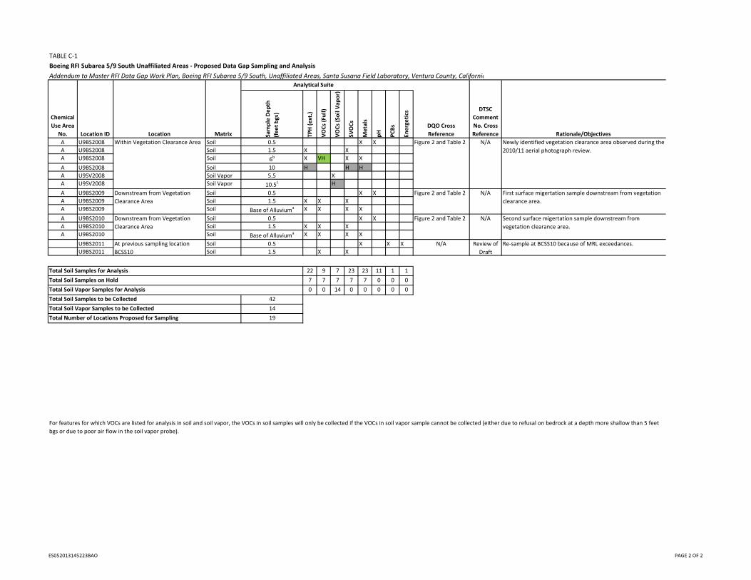
TABLE C‐1
Boeing RFI Subarea 5/9 South Unaffiliated Areas ‐ Proposed Data Gap Sampling and Analysis
Addendum to Master RFI Data Gap Work Plan, Boeing RFI Subarea 5/9 South, Unaffiliated Areas, Santa Susana Field Laboratory, Ventura County, California
Chemical
Use Area
No. Location ID Location Matrix Sample Depth
(feet bgs)
TPH (ext.)
VOCs (Full)
VOCs (Soil Vap
or)
SVOCs
Metals
pH
PCBs
Energetics
DQO Cross
Reference
DTSC
Comment
No. Cross
Reference Rationale/Objectives
Analytical Suite
A U9BS2008 Soil 0.5 X X
A U9BS2008 Soil 1.5 X X
A U9BS2008 Soil 6b X VH X X
A U9BS2008 Soil 10 H H H
A U9SV2008 Soil Vapor 5.5 X
A U9SV2008 Soil Vapor 10.5c H
A U9BS2009 Soil 0.5 X X
A U9BS2009 Soil 1.5 X X X
A U9BS2009 Soil Base of Alluviuma X X X X
A U9BS2010 Soil 0.5 X X
A U9BS2010 Soil 1.5 X X X
A U9BS2010 Soil Base of Alluviuma X X X X
U9BS2011 Soil 0.5 X X X
U9BS2011 Soil 1.5 X X
Total Soil Samples for Analysis 22 9 7 23 23 11 1 1
Total Soil Samples on Hold 7 7 7 7 7 0 0 0
Total Soil Vapor Samples for Analysis 0 0 14 0 0 0 0 0
Total Soil Samples to be Collected 42
Total Soil Vapor Samples to be Collected 14
Total Number of Locations Proposed for Sampling 19
For features for which VOCs are listed for analysis in soil and soil vapor, the VOCs in soil samples will only be collected if the VOCs in soil vapor sample cannot be collected (either due to refusal on bedrock at a depth more shallow than 5 feet
bgs or due to poor air flow in the soil vapor probe).
Downstream from Vegetation
Clearance Area
First surface migertation sample downstream from vegetation
clearance area.
Downstream from Vegetation
Clearance Area
Second surface migertation sample downstream from
vegetation clearance area.
Within Vegetation Clearance Area Newly identified vegetation clearance area observed during the
2010/11 aerial photograph review.
Figure 2 and Table 2 N/A
Figure 2 and Table 2 N/A
Figure 2 and Table 2 N/A
At previous sampling location
BCSS10
N/A Review of
Draft
Re‐sample at BCSS10 because of MRL exceedances.
ES052013145223BAO PAGE 2 OF 2
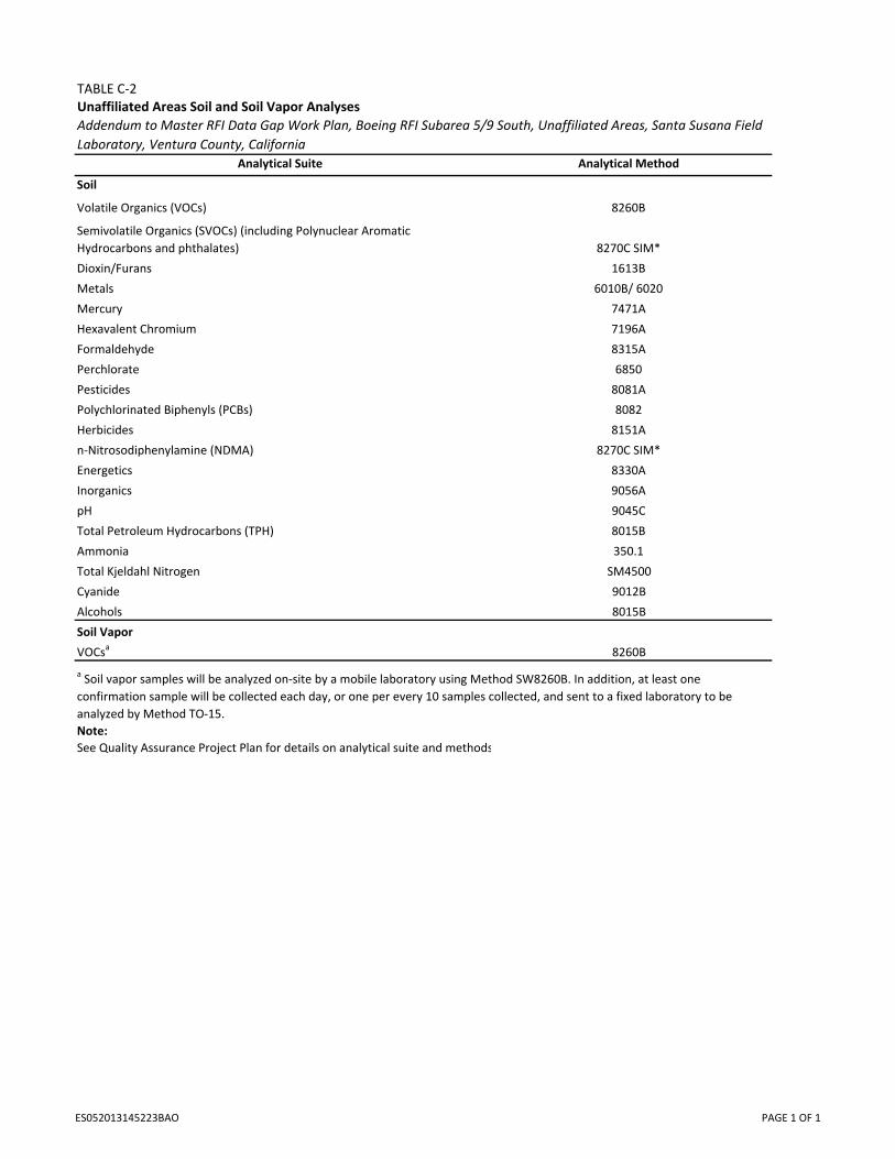
TABLE C‐2Unaffiliated Areas Soil and Soil Vapor Analyses
Analytical Suite Analytical Method
Soil
Volatile Organics (VOCs) 8260B
Semivolatile Organics (SVOCs) (including Polynuclear Aromatic
Hydrocarbons and phthalates) 8270C SIM*
Dioxin/Furans 1613B
Metals 6010B/ 6020
Mercury 7471A
Hexavalent Chromium 7196A
Formaldehyde 8315A
Perchlorate 6850
Pesticides 8081A
Polychlorinated Biphenyls (PCBs) 8082
Herbicides 8151A
n‐Nitrosodiphenylamine (NDMA) 8270C SIM*
Energetics 8330A
Inorganics 9056A
pH 9045C
Total Petroleum Hydrocarbons (TPH) 8015B
Ammonia 350.1
Total Kjeldahl Nitrogen SM4500
Cyanide 9012B
Alcohols 8015B
Soil Vapor
VOCsa 8260B
Note:
See Quality Assurance Project Plan for details on analytical suite and methods
Addendum to Master RFI Data Gap Work Plan, Boeing RFI Subarea 5/9 South, Unaffiliated Areas, Santa Susana Field
Laboratory, Ventura County, California
a Soil vapor samples will be analyzed on‐site by a mobile laboratory using Method SW8260B. In addition, at least one
confirmation sample will be collected each day, or one per every 10 samples collected, and sent to a fixed laboratory to be
analyzed by Method TO‐15.
ES052013145223BAO PAGE 1 OF 1

Figure

FIGURE C-1Proposed Sample Locations for the Subarea 5/9 South Unaffiliated AreasAddendum to Master RFI Data Gap Work PlanBoeing RFI Subarea 5/9 South, Unaffiliated AreasSanta Susana Field Laboratory, Ventura County, California
VICINITY MAP
###
### # #
## #
#
!!!
!! ! !(
((
(( ( (*
**
*** * *
** *
*U9BS2011
A
0 600300
Feet
BASEMAP LEGENDBoeing RFI Site
RFI Group Boundary
Administrative Boundary
Chemical Use Area (CUA)1 CUA Reference Number
CUA Cluster (CC)
Boeing RFI Subarea 5/9 South
Area being investigated by NASA as part of the Coca RFI site
Potential CUAA Potential CUA ID
Soil CMS Area
Soil Vapor CMS Area
Features' Debris Point
!! Transformer Pole
Pipeline
Leach Field Line
Debris Line
Drainage Channel
Operational Channel
Dirt RoadPaved Road
Rock Outcrop
Pond
Transformer Pad
! ! ! ! !
! ! ! ! !
! ! ! ! !
! ! ! ! !
Structure
Aboveground Storage TankUnderground Storage TankNot Yet Determined
Storage Yard
Debris Area
Disturbed Soil
Vegetation Clearing
Excavation Area
U U U UU U U UU U U U
Undefined Feature
Spray Field
Septic Tank
Leach Field Area
Sump
NASA
AREA I
AREA II
AREA IV
AREA III
UNDEVELOPEDLAND
UNDEVELOPED
LAND
UNDEVELOPED LAND
$ 1 in = 600 ft
SCO K:\BOEING\362070\MAPFILES\2013\DQO\SUBAREA5_9_SOUTH\REPORTFIGURES\SUB59S_FIGUREC-1_PROPSAMPLES.MXD RANHORN 5/17/2013 9:54:09 AM
LEGEND! Proposed Soil Vapor Sample Location
# Proposed Soil Sample Location
!(Proposed Soil Vapor Sample Location on hold until further evaluation of sample results
#*Proposed Soil Sample Location on hold until further evaluation of sample results
#
#
#
#
#
# ##
#
##
!
!
!
!
! !!(
(
(
(
( ((*
*
*
*
*
* **
*
**
U9BS2000
U9BS2001
U9BS2002
U9BS2004
U9BS2005U9BS2006
U9BS2007 U9BS2008
U9BS2010U9BS2003
U9BS2009
U9SV2000
U9SV2001
U9SV2002
U9SV2005
U9SV2006U9SV2007 U9SV2008
A
Sample Locations Detail0 100 200
Feet