Embed Size (px)
Citation preview

7/31/2019 5 SoilSurvey Handout
http://slidepdf.com/reader/full/5-soilsurvey-handout 1/24
Accelerated Certification Training, Soil Survey
Information, October 2012
ACT PRESENTATION 5
WEB SOIL SURVEY AND SOILCLASSIFICATION INFORMATION
OCTOBER 2012
Proper use of the soil surveys in theOSTDS Program
David Hammonds, Environmental Manager Florida Department of Health Division of Disease Control and Health Protection Bureau of Environmental Health Onsite Sewage Programs 850-245-4570
ACT PRESENTATION 5WEB SOIL SURVEY AND SOIL
CLASSIFICATION INFORMATION
APRIL 2012Proper use of the soil surveys in the
OSTDS Program
David Hammonds, Environmental Manager
Florida Department of Health
Division of Disease Control and Health Protection
Bureau of Environmental HealthOnsite Sewage Programs
Where do you find information on
soils?USDA NRCS
WEB SOIL SURVEY
LEGACY SOIL SURVEYS (BOOKS)

7/31/2019 5 SoilSurvey Handout
http://slidepdf.com/reader/full/5-soilsurvey-handout 2/24
Accelerated Certification Training, Soil Survey
Information, October 2012
Soil Survey (Legacy Documents)
Soil Map from a Published Soil Survey
Soil Survey
• One for each county
• Format: paper, pdf, GIS, Web
• Paper: most are out of print and hard to find (but veryuseful)
• pdf: a digital replica of the paper, but only for a fewcounties
• GIS: geo data layers and attribute tables for use in GISsoftware
• WSS: (web soil survey) a website delivering the GIS datathrough a web browser so anyone can use it (more later)

7/31/2019 5 SoilSurvey Handout
http://slidepdf.com/reader/full/5-soilsurvey-handout 3/24
Accelerated Certification Training, Soil Survey
Information, October 2012
Soil Survey• Excellent for planning and recon
• Soil survey not meant for field-scale• Cannot be used for on-site delineation due
to issues of scale and accuracy
• Therefore must use soil indicators for on-site delineation
• Excellent for field use, especially when youare learning and find a soil other thanwhat is actually mapped.
Using Web Soil Survey (WSS)
• Now the official soil survey
• Replaces traditional paper copies of soil surveyreports
• Most soil surveys in US are available
• Additional interpretations available
• Interpretive tables refined and presented innew format
• Designed for parcels or projects – not entirecounty
New Web Soil Survey 2.3
• Newest version of WSS
• Has new features
• How to use the new WSS:
http://websoilsurvey.nrcs.usda.gov/app/Help/
WSS_HomePage_HowTo.pdf
7/31/2019 5 SoilSurvey Handout
http://slidepdf.com/reader/full/5-soilsurvey-handout 4/24
Accelerated Certification Training, Soil Survey
Information, October 2012
WEB SOIL
SURVEY 2.3Updated2/17/12

7/31/2019 5 SoilSurvey Handout
http://slidepdf.com/reader/full/5-soilsurvey-handout 5/24
Accelerated Certification Training, Soil Survey
Information, October 2012
Navigate by address, PLSS, etc.
Type in address, hit “view”
Then begin navigation by
Area of Interest (AOI)
How is this done?

7/31/2019 5 SoilSurvey Handout
http://slidepdf.com/reader/full/5-soilsurvey-handout 6/24
Accelerated Certification Training, Soil Survey
Information, October 2012
This is how-----
• Several ways to navigate to AOI– Quick Navigation Options
– Magnifying Tool
• Two ways to define AOI
– Rectangle
– Polygon
• Limited to 10,000 acres in size
Soil Map
• Only available if AOI is defined
• Soil Map tab will not activate until AOI is
defined
• You will forget to define AOI
• You will think WSS does not work
• You will (finally) realize you did not define your
AOI
Don’t zoom in on a single small
parcel!!
• Make a fairly large AOI with your specific
target area in the middle. This allows
observation of the surrounding soilrelationships.
• WATCH THE SCALE! There is a warningthat shows up when the scale gets too large.
Reduce scale to what the warning tells you thearea was originally mapped at (or close to it).

7/31/2019 5 SoilSurvey Handout
http://slidepdf.com/reader/full/5-soilsurvey-handout 7/24
Accelerated Certification Training, Soil Survey
Information, October 2012
Calibrate Scale on WSS
Click on Scale Button and followdirections.
Scale Indicator
How to calibrate scale
Warning language

7/31/2019 5 SoilSurvey Handout
http://slidepdf.com/reader/full/5-soilsurvey-handout 8/24
Accelerated Certification Training, Soil Survey
Information, October 2012
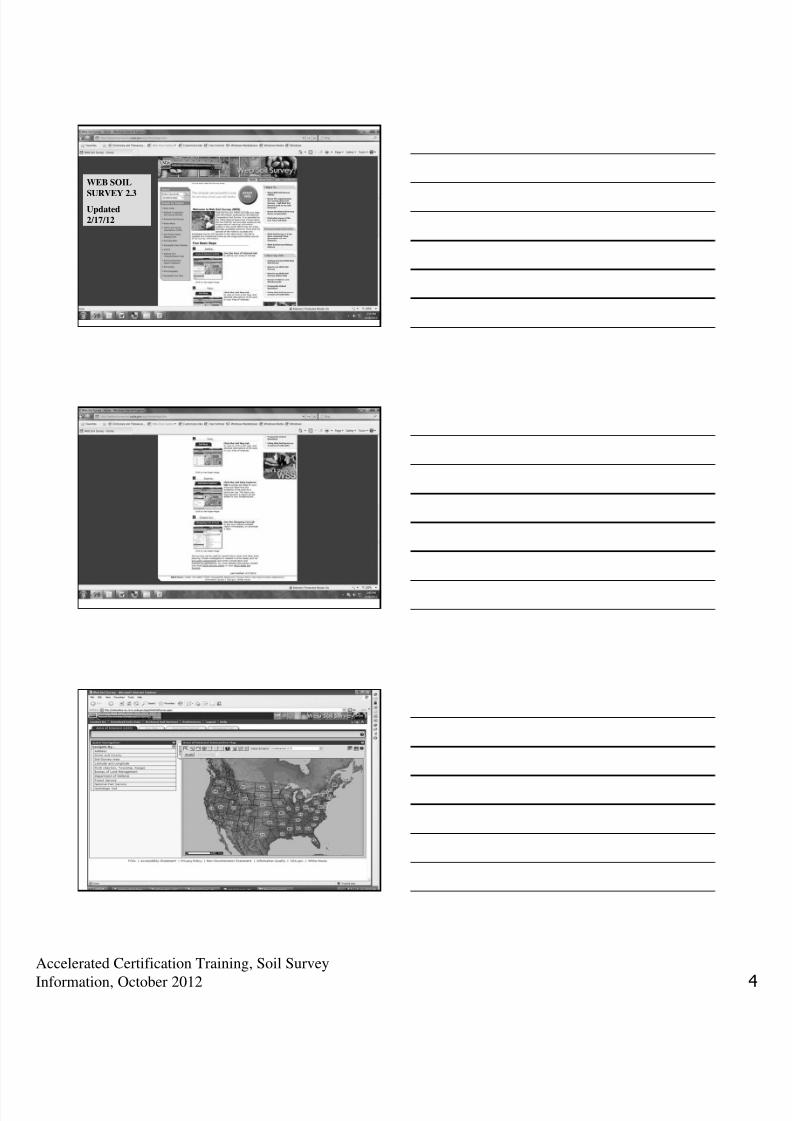
What you see after you make your Areaof Interest and click on the Soil Map
Tab (next slide)
SCALE
Notice the left side of the previous screen
• This information is the types and amounts of
soil (and water) that is included in your Area
of Interest, including the acreage mapped inthe AOI. Can be up to 10,000 acres in total.
• If you click on a map unit name, it will give youthe following information.

7/31/2019 5 SoilSurvey Handout
http://slidepdf.com/reader/full/5-soilsurvey-handout 9/24
Accelerated Certification Training, Soil Survey
Information, October 2012
7/31/2019 5 SoilSurvey Handout
http://slidepdf.com/reader/full/5-soilsurvey-handout 10/24
Accelerated Certification Training, Soil Survey
Information, October 2012
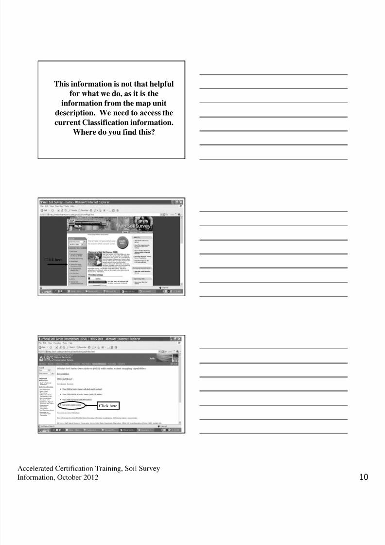
This information is not that helpful
for what we do, as it is theinformation from the map unit
description. We need to access the
current Classification information.Where do you find this?
Click here
Click here

7/31/2019 5 SoilSurvey Handout
http://slidepdf.com/reader/full/5-soilsurvey-handout 11/24
Accelerated Certification Training, Soil Survey
Information, October 2012
SAVE THIS TO “FAVORITES”
Type in the name of the soil, click “Process”
This is what you get. Click on “View Description”

7/31/2019 5 SoilSurvey Handout
http://slidepdf.com/reader/full/5-soilsurvey-handout 12/24
Accelerated Certification Training, Soil Survey
Information, October 2012
Classification Information

7/31/2019 5 SoilSurvey Handout
http://slidepdf.com/reader/full/5-soilsurvey-handout 13/24
Accelerated Certification Training, Soil Survey
Information, October 2012

7/31/2019 5 SoilSurvey Handout
http://slidepdf.com/reader/full/5-soilsurvey-handout 14/24
Accelerated Certification Training, Soil Survey
Information, October 2012
Soils Mapped by Counties• Soils are mapped for each county in Florida
• A minimum amount of soil must be found in thecounty for it to be mapped in the county.
• Just because a soil is not actually mapped in thecounty DOES NOT mean that the soil cannot befound there (assuming same temperature region).
• Therefore you may find a soil (or be given a soilname) that you do not recognize as mapped in thecounty.
• Look name up using the Official Soils Series
Description to find out more about the soil.
QUESTIONS???

7/31/2019 5 SoilSurvey Handout
http://slidepdf.com/reader/full/5-soilsurvey-handout 15/24
Accelerated Certification Training, Soil Survey
Information, October 2012
VEGETATION AND SOILS
VEGETATION AND SOILS
There is an intimate relationship between soil type and vegetation type. Plants have varying nutrient and water requirements, just as different soils have varying nutrient and water contents. Therefore, recognizing certain vegetative clues can help us predict certain soil characteristics. The cypress tree, for example, almost always grows in soils that have a SHWT at or above the surface.
Ecological Plant Communities
• Coastal Strand
• Sand Pine Scrub
• Longleaf Pine-Turkey Oak Hills
• Mixed Hardwood and Pine• Flatwoods (contains Pine and Saw Palmettos)
• Upland Hardwood Hammocks
• Wetland Hardwood Hammock
• Swamps
7/31/2019 5 SoilSurvey Handout
http://slidepdf.com/reader/full/5-soilsurvey-handout 16/24
Accelerated Certification Training, Soil Survey
Information, October 2012
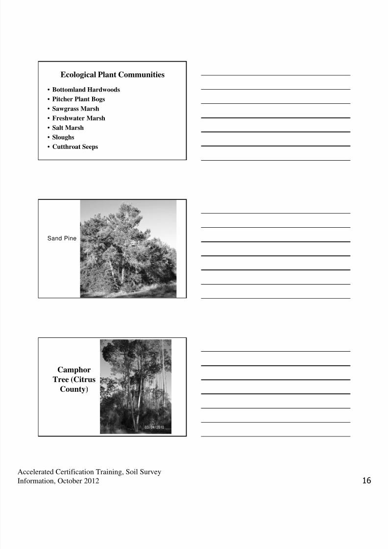
Ecological Plant Communities
• Bottomland Hardwoods
• Pitcher Plant Bogs
• Sawgrass Marsh
• Freshwater Marsh
• Salt Marsh
• Sloughs
• Cutthroat Seeps
Sand Pine
Camphor
Tree (CitrusCounty)

7/31/2019 5 SoilSurvey Handout
http://slidepdf.com/reader/full/5-soilsurvey-handout 17/24
Accelerated Certification Training, Soil Survey
Information, October 2012
Cattail(without
seeds)
Sand Oakand Saw
Palmetto
Everglades

7/31/2019 5 SoilSurvey Handout
http://slidepdf.com/reader/full/5-soilsurvey-handout 18/24
Accelerated Certification Training, Soil Survey
Information, October 2012
Turkey Oak
Pine Flatw oods

7/31/2019 5 SoilSurvey Handout
http://slidepdf.com/reader/full/5-soilsurvey-handout 19/24
Accelerated Certification Training, Soil Survey
Information, October 2012
PineFlatwoods
Saw Palmetto, Serenoa repens

7/31/2019 5 SoilSurvey Handout
http://slidepdf.com/reader/full/5-soilsurvey-handout 20/24
Accelerated Certification Training, Soil Survey
Information, October 2012
Cabbage Palm
Sabal Palmetto
Cypressand
CabbagePalm in
floodplain
Red Maple

7/31/2019 5 SoilSurvey Handout
http://slidepdf.com/reader/full/5-soilsurvey-handout 21/24
Accelerated Certification Training, Soil Survey
Information, October 2012
RedMapleSamara
(fruit)
Black Titi(Cliftonia
monophylla)in bloom
BlackTiti
close-
up

7/31/2019 5 SoilSurvey Handout
http://slidepdf.com/reader/full/5-soilsurvey-handout 22/24
Accelerated Certification Training, Soil Survey
Information, October 2012
Salt Marsh
Sawgrass
DEP Plant
Identification
Manual forwetter areas

7/31/2019 5 SoilSurvey Handout
http://slidepdf.com/reader/full/5-soilsurvey-handout 23/24
Accelerated Certification Training, Soil Survey
Information, October 2012
FLORIDA WETLAND PLANTS
• The manual is available from the University of Florida/The Institute of Food and AgriculturalSciences (UF/IFAS) Publications, P.O. Box110011, Gainesville, Florida, 32611. The cost is$35.00 plus $4.00 shipping and handling.Florida addresses must add the appropriatesales tax. Purchase orders, check, or charges(MasterCard, or VISA by calling 1-800-226-1764) are accepted. (as of 2/15/12)
QUESTIONS???
METHODS OF SOILINVESTIGATION

7/31/2019 5 SoilSurvey Handout
http://slidepdf.com/reader/full/5-soilsurvey-handout 24/24
METHODS OF SOIL INVESTIGATION
• Obtaining Soil Survey Data
• Evaluation of Surroundings
PROBLEM SOILS• Filled Areas
• Local Knowledge of Area Soils
• Consult OSTDS Program Office
• Consult Soil Scientist
• QUESTIONS????