Embed Size (px)
Citation preview

1
NeoStencil – Live Online Classes - IAS/IES/GATE/SSC/PSC | +91 95990 75552 | [email protected]
90 Days UPSC Mains Optional Answer Writing
Initiative
Geography – Paper 2
Question and Model Answers from Subject Experts
2
NeoStencil – Live Online Classes - IAS/IES/GATE/SSC/PSC | +91 95990 75552 | [email protected]
11-Dec-2017 – Question 1
What do you understand by soil pollution? Delineate the areas vulnerable to it in India and suggest remedial measures. 2017 (Words – 200)
Model Answer
The soil is a thin layer on the surface of the earth, composed of mineral matters, organic and inorganic compounds. There is a delicate natural balance of various compounds present in the soil. When the balance is lost and there is an increase in contamination of soil due to anthropogenic or natural factor, it is termed soil
pollution.
Various causes of soil pollution
Improper Agricultural practices leading to the high use of chemical agents like fertilizers, insecticide and pesticide is the dominant cause of soil pollution.
Over-irrigation of soil leading to salinity and alkalinity Improper solid waste management leading to leaching of harmful chemicals
in soil. Dumping of industrial waste on open fields and leaching of heavy metals
from these sites. Mining Activity, especially the open cast mining releases small particulate
matters that deposit in the nearby area and make soil contaminated.
The areas vulnerable to soil pollution in India are
Industrial areas: Surat, Kanpur, Lucknow
Urban areas: Delhi NCR, Kolkata, Banglore, Mumbai
Salinity: Indra Gandhi Canal command area.
Fertilizer/ Pesticide: Punjab Haryana and western UP
Mining:: Jharkhand, Chhattisgarh and Odisha
Locate these areas on the Map of India.
3
NeoStencil – Live Online Classes - IAS/IES/GATE/SSC/PSC | +91 95990 75552 | [email protected]
Remedial Measures
Practicing organic farming methods and minimizing the use of chemical fertilizers.
Using sprinkle irrigation, drip irrigation and increasing awareness about proper irrigation practices to farmers.
Proper solid waste management in the urban areas like recycling, segregation of biodegradable and non-biodegradable waste.
Strict regulation for Industrial pollution and mining activity. Increased community awareness and cooperation to fight the menace by
adopting a more sustainable life style.
4
NeoStencil – Live Online Classes - IAS/IES/GATE/SSC/PSC | +91 95990 75552 | [email protected]
11-Dec-2017 – Question 2
Describe the flood-prone areas and their management problems in the Ganga Plains. 2016 (words-200)
Model Answer
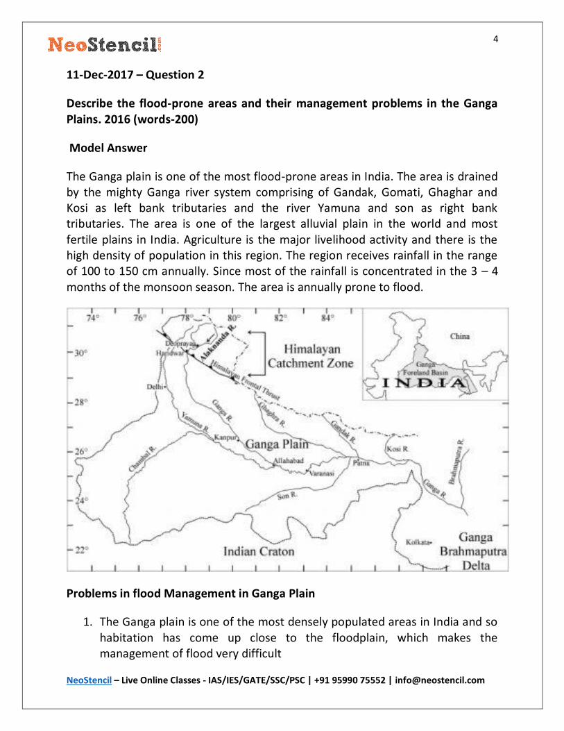
The Ganga plain is one of the most flood-prone areas in India. The area is drained by the mighty Ganga river system comprising of Gandak, Gomati, Ghaghar and Kosi as left bank tributaries and the river Yamuna and son as right bank tributaries. The area is one of the largest alluvial plain in the world and most fertile plains in India. Agriculture is the major livelihood activity and there is the high density of population in this region. The region receives rainfall in the range of 100 to 150 cm annually. Since most of the rainfall is concentrated in the 3 – 4 months of the monsoon season. The area is annually prone to flood.
Problems in flood Management in Ganga Plain
1. The Ganga plain is one of the most densely populated areas in India and so habitation has come up close to the floodplain, which makes the management of flood very difficult

5
NeoStencil – Live Online Classes - IAS/IES/GATE/SSC/PSC | +91 95990 75552 | [email protected]
2. Over-dependence on agriculture for the livelihood that does not allow people to leave their land as fallow to prevent crop damage due to flooding.
3. Lack of resources in the administrative department to manage large-scale flooding.
4. Lack of accurate flood forecasting methods and rapid evacuation strategy. 5. Rapid Deforestation in catchment areas to acquire more land for
agriculture.
Solution
1. Flood Zonation 2. Creation of water Harvesting infrastructure. 3. Strict Regulation of construction activity close to the floodplain 4. Construction of embankment and afforestation in the catchment area.
6
NeoStencil – Live Online Classes - IAS/IES/GATE/SSC/PSC | +91 95990 75552 | [email protected]
13-Dec-2017 – Question 1
Interlinking of rivers may serve as a major source of assured irrigation and all-
weather inland navigation in India. Comment on its feasibility taking into
account physical, economic and ecological implication. 2017 (250 words)
Model Answer
India is a diverse country grappled with the twin challenge of flooding and drought at the same time. To overcome this twin challenge, linking of Indian rivers is considered as the best solution. On the one hand the problems of flooding and drought will be solved and on the other hand, it will provide perennial waterways as a cheap mode of transportation.
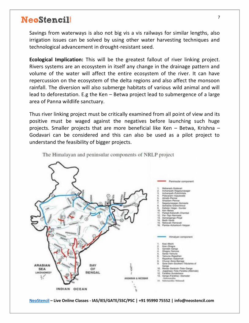
The River interlinking project envisages connecting the Himalayan Rivers and the Peninsular Rivers through a network of canals and reservoir to divert the surplus water from Himalayan rivers to the peninsular rivers. But the project has many unanswered questions that must be satisfied before commissioning the actual work.
Challenges in the Implementation of the project:
Physical Challenges: The implementation of the project will require huge stretches of land for construction of canal and reservoirs. The Gangetic region is densely populated and dependent on agriculture which will create problems in land acquisition and rehabilitation of people.
The diversion of water from the north to south is not feasible naturally considering the physiographic barriers like the Vindhya, Satpura ranges and the increase in height when we move from north to south.
The hard granitic landscape in Deccan plateau makes the construction of canals
difficult and expensive.
Economic Challenges: The Project is a Mammoth with any scale of imagination. It would require lakhs of crores of investment and debt. It will lead to huge debt on government and government may divert funds from important social security
schemes.
7
NeoStencil – Live Online Classes - IAS/IES/GATE/SSC/PSC | +91 95990 75552 | [email protected]
Savings from waterways is also not big vis a vis railways for similar lengths, also irrigation issues can be solved by using other water harvesting techniques and technological advancement in drought-resistant seed.
Ecological Implication: This will be the greatest fallout of river linking project. Rivers systems are an ecosystem in itself any change in the drainage pattern and volume of the water will affect the entire ecosystem of the river. It can have repercussion on the ecosystem of the delta regions and also affect the monsoon rainfall. The diversion will also submerge habitats of various wild animal and will lead to deforestation. E.g the Ken – Betwa project lead to submergence of a large area of Panna wildlife sanctuary.
Thus river linking project must be critically examined from all point of view and its positive must be waged against the negatives before launching such huge projects. Smaller projects that are more beneficial like Ken – Betwa, Krishna – Godavari can be considered and this can also be used as a pilot project to
understand the feasibility of bigger projects.

8
NeoStencil – Live Online Classes - IAS/IES/GATE/SSC/PSC | +91 95990 75552 | [email protected]
Note: The model answer is only for your reference and not an ideal answer for the
question.
9
NeoStencil – Live Online Classes - IAS/IES/GATE/SSC/PSC | +91 95990 75552 | [email protected]
13-Dec-2017 – Question 2
Delineate the coalfields of India and mention their distinctive features. 2013 (words – 200)
Model Answer
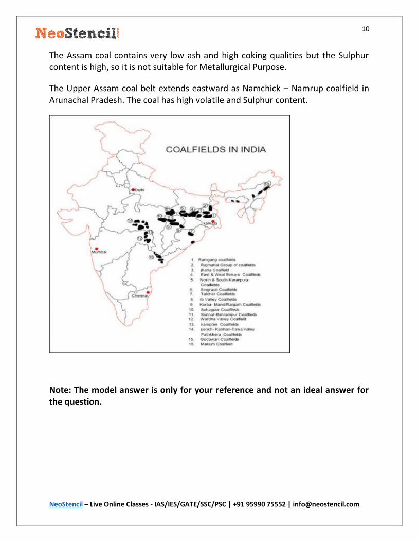
The coal fields in India can be broadly divided into two categories.
The Gondwana coalfield
The Tertiary Coalfield
The Gondwana coalfields account for 98 % of total reserve and 99 % of total production in India. It is the store house of India’s Metallurgical and superior quality coal. Gondwana coal is said to be about 250 million years old. The coal are of both coking as well as non-coking variety. Types of coal found are bituminous and sub-bituminous but Anthracite coal is not found in these fields. The Gondwana coals have ash content up to 30 % and carbon in the range of 55 – 60 %. These coals are free from moisture but it contains Sulphur and Phosphorus in small quantity.
The major Gondwana coal fields include
The korba , The Birampur, The Hasdo – Arand and theTatapani – Ramkota coalfields in Chattisgarh.
The Jharia, The Bokaro, The karharbari and the Karanpur and Ramgarh coalfield in Jharkhand.
The Talcher, The Rampur – Himgiri coalfields in Odisha Singrauli and Umaria coalfield in Madhya Pradesh.
The Tertiary coal field bears coals of younger age 15 – 60 million years old. They are found in the extra peninsular area. This coal has generally low carbon and a high percentage of moisture and Sulphur. Lignite and Peat are the types of coal found in this deposit. The tertiary coal fields generally occur in association with limestone and slates.
The major coal fields in Assam are Makum, Nazira, Mikir Hills and Lakhani.
10
NeoStencil – Live Online Classes - IAS/IES/GATE/SSC/PSC | +91 95990 75552 | [email protected]
The Assam coal contains very low ash and high coking qualities but the Sulphur content is high, so it is not suitable for Metallurgical Purpose.
The Upper Assam coal belt extends eastward as Namchick – Namrup coalfield in Arunachal Pradesh. The coal has high volatile and Sulphur content.
Note: The model answer is only for your reference and not an ideal answer for the question.

11
NeoStencil – Live Online Classes - IAS/IES/GATE/SSC/PSC | +91 95990 75552 | [email protected]
15-Dec-2017 – Question 1
Account for the geographical distribution of groundwater resources of India. How serious is its depletion in recent decades? 2015 (words – 250)
Model Answer
India is a diverse country with varied geological, climatological and topographical features. All these variations give rise to areas with different groundwater potential.
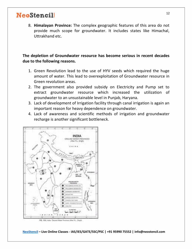
The groundwater distribution of India has been explained by RL Singh. He divided the entire country into 8 groundwater province which is explained below.
1. Pre – Cambrian Crystalline Province: It covers over half of the countries geographical area which include states like Tamil Nadu, Andhra Pradesh, Karnataka etc. It is deficient in groundwater resource.
2. Pre – Cambrian Sedimentary Province: It extends over cuddapha and Vindhayan basin, covering states of Eastern Rajasthan, MP etc. This area is also not significant with respect to the ground water resource.
3. Gondwana Sedimentary Province: This extends to the Godavari river basin and is a good source of groundwater.
4. Deccan Trap Province: This area has an impermeable basaltic layer which makes percolation of water difficult and so a poor source of groundwater. Some aquifers are available only in fractures where secondary porosity has developed due to weathering. States like Maharashtra and North Karnataka fall in this category.
5. Cenozoic Sedimentary Province: This province has tertiary sandstone and is a good source of groundwater. It includes coastal areas of Tamil Nadu, Kerala and Gujarat.
6. Cenozoic Fault Basin: This includes the rift zones of Narmada and Tapi and is a good source of groundwater.
7. Ganga – Brahmaputra Alluvial Province: This is the richest source of groundwater in India. The thick alluvial deposit has huge groundwater potential and is recharged by perineal rivers. It includes states like UP, Bihar, Punjab Haryana etc.
12
NeoStencil – Live Online Classes - IAS/IES/GATE/SSC/PSC | +91 95990 75552 | [email protected]
8. Himalayan Province: The complex geographic features of this area do not provide much scope for groundwater. It includes states like Himachal, Uttrakhand etc.
The depletion of Groundwater resource has become serious in recent decades
due to the following reasons.
1. Green Revolution lead to the use of HYV seeds which required the huge amount of water. This lead to overexploitation of Groundwater resource in Green revolution areas.
2. The government also provided subsidy on Electricity and Pump set to extract groundwater resource which increased the utilization of groundwater to an unsustainable level in Punjab, Haryana.
3. Lack of development of Irrigation facility through canal irrigation is again an important reason for heavy dependence on groundwater.
4. Lack of awareness and scientific methods of irrigation and groundwater recharge is another significant bottleneck.
13
NeoStencil – Live Online Classes - IAS/IES/GATE/SSC/PSC | +91 95990 75552 | [email protected]
Thus the depletion of groundwater has reached an alarming stage and need immediate attention of policymakers and the community dependent on them.
Steps that can be taken are:
1. Community awareness program. 2. Increased local level participation in watershed management and water
harvesting techniques. 3. Developing a new variety of seeds suitable to the Agro-climatic condition of
India. 4. Using sprinklers and drip irrigation.
14
NeoStencil – Live Online Classes - IAS/IES/GATE/SSC/PSC | +91 95990 75552 | [email protected]
15-Dec-2017 – Question 2
Give an account of the development of renewable resources of India. 2016
(words – 200)
Model Answer
Geography of India has blessed it with a long coastline of 7500 km suitable for wind, wave and tidal energy, Around 300 days of sunshine for solar power, the Himalayas in the North and North East as a perineal source of hydropower and
huge biomass potential due to fertile lands of India.
These geographic features make India an Ideal country for the development of renewable energy.
India has achieved substantial progress in the development of Renewable Energy in recent decades.
Solar Energy: The Installed solar capacity of India increased from 2 MW in 2008-09 to 3300 MW by 2015. There is a rapid increase in the solar capacity in India’s energy mix as India has committed for a 100GW of Installed capacity in solar energy by 2022. India has also taken lead in solar energy development by starting
an International solar alliance with countries in the tropical belt.
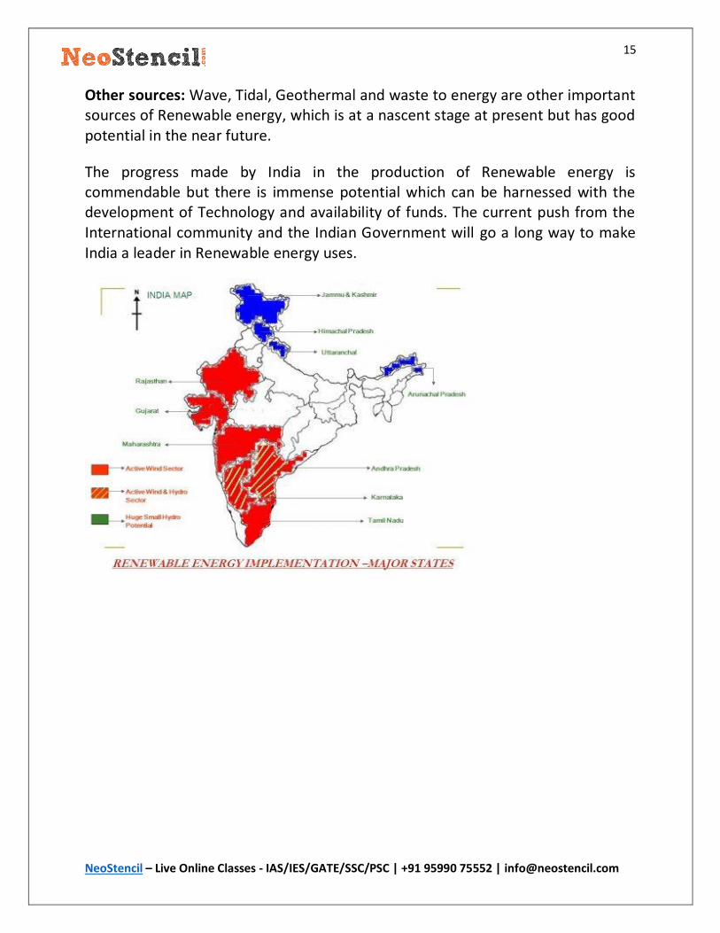
Wind Energy: Wind energy has shown a 26% year on year growth from 2002 onwards. The installed capacity increased from 1.5 k MW to 22.5 k MW by 2015.
The coastal states like Tamilnadu, Kerela, Gujarat has taken a lead in this sector.
Small hydropower (SHP): The installed capacity of SHP has increased from 2000 MW in 2006 to 4000 MW in 2015. Still, there is a lot of scope in this area as the unutilized capacity is around 15k MW can be tapped. This is a low hanging fruit and is available in states like Uttrakhand, Himachal Pradesh and North – Eastern states.
Biomass Power: The installed capacity of biomass has increased from 3200 MW to 4200 MW by 2015. The potential of biomass power is estimated to be 17.5 k MW by MNRE. India has a huge potential in this area due to its huge cattle population and agricultural biomass production.
15
NeoStencil – Live Online Classes - IAS/IES/GATE/SSC/PSC | +91 95990 75552 | [email protected]
Other sources: Wave, Tidal, Geothermal and waste to energy are other important sources of Renewable energy, which is at a nascent stage at present but has good potential in the near future.
The progress made by India in the production of Renewable energy is commendable but there is immense potential which can be harnessed with the development of Technology and availability of funds. The current push from the International community and the Indian Government will go a long way to make India a leader in Renewable energy uses.
16
NeoStencil – Live Online Classes - IAS/IES/GATE/SSC/PSC | +91 95990 75552 | [email protected]
25-Dec-2017 – Question 1
‘In spite of various negative impacts of Green Revolution, there is a demand for New Green Revolution’. Elaborate. 2014 (200)
Model Answer
India introduced the green revolution in the 1960s to end its vulnerable position in food security. The green revolution was a packaged program which provided HYV seeds, Fertilizer, Pesticide and irrigation facility to increase the farm productivity. This program increased the food productivity mainly wheat and rice
to manifold and India attended food security.
However, Green revolution had its pitfall in terms of ecological problems
1. Ecological Imbalance: Loss of biodiversity, soil pollution, depletion of groundwater etc.
2. Green revolution resulted in the regional disparity between western and eastern part of Gangetic plain and economic disparity between small and large farm holders.
3. Unemployment to the rural labourers due to mechanization of agriculture.
In spite of the negative impact, the success of green revolution cannot be dwarfed. It gave India a sense of pride and self-sufficiency as it was no longer a begging bowl. The green revolution increased the Per capita income in Punjab, Haryana and West UP which improved the living standard of farmers. Another spillover effect is the growth of industries to provide tractors, Fertilizer and pesticide, Agro-based industries etc. All this lead to the cumulative growth of this
region.
There is a demand for new Green Revolution due to:
1. The Increased economic prosperity of Farmers in the Green Revolution areas.
2. The eastern states have a good condition for new green revolution perennial source of water, fertile alluvial land etc.
3. The increasing population of India which is putting a strain on its food security.
4. Vulnerability in food security that may arise due to Global climate change.
17
NeoStencil – Live Online Classes - IAS/IES/GATE/SSC/PSC | +91 95990 75552 | [email protected]
5. The decrease in productivity in the initial green revolution areas. 6. The decrease in the availability of land due to urbanization and
development of industries etc.
However, In spite of the fact that the new green revolution is the need of the hour for India. We must keep the words of Father of Green revolution. That India needs to move from Green revolution to Evergreen Revolution, which
incorporates technology in harmony with ecology.
18
NeoStencil – Live Online Classes - IAS/IES/GATE/SSC/PSC | +91 95990 75552 | [email protected]
25-Dec-2017 – Question 2
Explain how modernization of Indian agriculutre is affected by unfavourable institutional factors with suitable examples. 2015 (200)
Model Answer
There are various parameters on which the modernization of Agriculture is measured such as:
Use of HYV / GM seeds in agriculture. Use of Fertilizer, pesticide, Insecticides etc. Use of modern farm equipment like Tractors, Tillers, Harvester, Thrasher
etc. High productivity per unit hectare of land. Perennial source of irrigation Insurance facility for crop failure Availability of capital for buying input materials.
The institutional factor plays the most important role in fulfilling the parameters on which modernization of agriculture depends. But due to continuous failure of institutional factors in supporting Indian Agriculture, The contribution of Agriculture has come down from 50-60 % to 15% of GDP from Independence to the present.
Failure of Institutional factors:
1. Irrigation Facility: The irrigation facility is still limited to only 40% of the cultivable land of India, which increases the vulnerability of farmers in rainfed regions due to the dependency of monsoon rain.
2. Capital Availability: In spite of various scheme for agricultural loans still the actual availability of loans to poor farmers is negligible due to corruption, tedious process of loan by banking sectors and delay in processing. This increases the chances of taking loan by farmers from money lenders at an exorbitant rate which decreases their profitability.
3. Technical support: Lack of availability of technical support to the farmers to make them aware of good agriculture practice to improve their agriculture income.
19
NeoStencil – Live Online Classes - IAS/IES/GATE/SSC/PSC | +91 95990 75552 | [email protected]
4. Crop Insurance: Still after independence, only 22 % of farmers are covered by insurance schemes, due to lack of insurance any failure of crop due to unforeseen factors results in debt and creates disincentives for the agriculture sector.
5. Infrastructure: lack of metalled road, warehouse/ cold storage facility, Marketing facility causes loss to farmers even if they have good agriculture productivity. The lack of these infrastructures in one of the major reason for lack of modernization of agriculture sector.
Thus there is a lot of potential in Indian Agriculture sector which can be properly harnessed if active institutional support is available to modernize Indian Agriculture. Some of the steps taken by the government are Fasal Bima Yogna,
Mera Gaon Mera Gaurav, Har khet ko Pani, Soil Health card. etc.
20
NeoStencil – Live Online Classes - IAS/IES/GATE/SSC/PSC | +91 95990 75552 | [email protected]
27-Dec-2017 – Question 1
Distinguish between ‘agricultural productivity’ and ‘agricultural efficiency’, and
bring out the disparity in regional distribution of agricultural efficiency. 2015
(250)
Model Answer
Agriculture Productivity Agriculture efficiency
Agriculture Productivity is a quantitative
analysis
Agriculture Efficiency is a qualitative
analysis.
It depends on the efficient utilization of
the factors of production viz. abiotic
factor, labour, capital etc.
It depends on the properties and
qualities of various inputs and the
manner in which they are combined and
put to use for production.
It is the gross estimation of total output. It is measured in terms of profitability.
Productivity can be used to compare
areal unit in a similar agro-climatic
condition for a unique crop
Efficiency can be applied across agro-
climatic conditions and various crops as
efficiency mean the best possible
utilization of available resources.
Efficiency is the maximum possible output that can be obtained from the available resources when putting to combined use in production.
The Kendall ranking coefficient method can be used to give disparity in the regional distribution of agriculture efficiency. Actually, Kendall’s classification was used to measure productivity but the same also give fairly good Idea of
agriculture efficiency.
Based on this classification India has been divided into five regions.
21
NeoStencil – Live Online Classes - IAS/IES/GATE/SSC/PSC | +91 95990 75552 | [email protected]
VHPR: States like Punjab, Haryana, Deltas of Krishna – Godavari, Kaveri, Southwest Maharashtra. Factors involved are Green revolution, Assured irrigation, Mechanization of agriculture, capitalistic agriculture.
HPR: East –UP, Ganga Plains, Assam Plain, River valley of peninsula etc. Factors involved are rich alluvial soil, partly irrigated, high cropping intensity, cheap labour.
MPR: Malwa Pleatue, Gujarat Plain, Tamil Nadu Pleatue, Coastal areas. Factors involved are Moderate land capability, soil responsive to irrigation and fertilizers, unavailability of assured irrigation.
LPR: Southern Pleatue having 60cm rainfall, Bundelkhand, Chota Nagpur. Factors involved are Physiographic constraints, poor quality of soil, Tribal economy.
VLPR: Rain Shadow area of the peninsula, Kutchh, Rajasthan, Himalayan Region. Factors involved are complex topography, climatic condition, poor soil quality, lack of rainfall.
22
NeoStencil – Live Online Classes - IAS/IES/GATE/SSC/PSC | +91 95990 75552 | [email protected]
27-Dec-2017 – Question 2
With the help of a map, indicate the principal areas of dryland farming in the country and account for farmers’ suicides mainly in those areas. 2015 (200)
Model Answer
Dryland Farming is practised in areas with less than 75 cm annual rainfall. These areas are mainly concentrated in the western part of the country. The area extends from Kashmir in the north to Kanyakumari in the south with a small gap in Himachal and J&k.
The principal areas of dry farming are whole of Rajasthan, Punjab and Haryana. The western part of MP and UP, Vidarbha and Marathwada region of Maharashtra, the Pleatue region of eastern Karnataka, Telangana etc.
It is estimated dry farming accounts for 22% of the agricultural land of the country.
Reasons for Farmers suicide in dry farming areas:
1. Rainfall is unpredictable and unreliable in this region. The variability in rainfall is 20 to 60 % which causes uncertainty in terms of floods, droughts and famine. This leads to crop failure and farmers fall into the trap of debt.
2. Large areas are covered by sandy soil which lacks nutrient material for soil fertility, due to poor fertility productivity is very low. So whatever is produced is barely sufficient for self-requirement which leads to poverty, hunger and mental stress.
3. The irrigation facility in non-existent in these areas which could have increased the productivity by utilizing the modern agriculture inputs.
4. Majority of farmers are poor in these regions and cannot afford inputs like better seed, fertilizers and farm machine etc.
5. Large areas of dry farming lack basic infrastructural facilities like market, transport, storage, refrigeration etc. The farmers are forced to distress sale in the absence of these facilities and fail to get remunerative prices for their products.
6. Lack of industrial growth in the region which could have provided necessary
financial support to the areas.
23
NeoStencil – Live Online Classes - IAS/IES/GATE/SSC/PSC | +91 95990 75552 | [email protected]
The cumulative effect of all these factors has led to increasing in farmers suicide in these areas.
However the government has been trying to improve the vulnerable situation by providing livelihood through schemes like MGNERAGA, Provision of agriculture loans through by universalizing banking through Jan Dhan Yojna, Crop insurance through Pradhan Mantri Fasal Bima Yojna. All these schemes are in the right
direction to help distressed farmers in this region.
Government is also investing in Micro irrigation projects and drip and sprinkler irrigation to increase the efficiency of water utilization in these areas.
24
NeoStencil – Live Online Classes - IAS/IES/GATE/SSC/PSC | +91 95990 75552 | [email protected]
29-Dec-2017 – Question 1
Discuss the potentiality and present status of horticulture in the Western and
Central Himalaya. 2013 (200)
Model Answer
The western and central Himalayan region has great potential for Horticulture crops. This agro-climatic region lies between the western Himalayan cold arid region in the north and the north plain region in the south and has warm sub-humid to the humid climate. The areas extend over Uttrakhand, Himachal Pradesh and southeastern part of j&k. The region has a long growing season of 180 t0 210 days, Brown and podzol soil gives natural support to fruits cultivation. The ecological condition of this region is suitable for horticulture and thus has
great potential for horticulture.
Other factors that contribute to its potentiality are the institutional support by the government in terms of better variety of seeds, easy loan availability, developed market and transport facility, subsidy, clustered development
approach, greenhouse facility etc.
Reform in APMC act and development of fruit markets close to the farm, storage facilities, online marketing practice, contract farming etc.
Availability of Delhi – NCR as one of the dominant market for horticulture crop is also one of the factors that contributes to the development of this sector in this region.
Status of Horticulture in the region:
Jammu & Kashmir: Horticulture is one of the most important economic activity in J&K. The production has risen from 1.8 MT in 1972 -73 to 25 LMT in 2015. The sector contributes 6000 crores to state GDP. The state has an eminent position in Apples and Walnut in the country.
Himachal Pradesh: 37% of the cultivable area of the state is engaged in Horticulture. Himachal Pradesh produced 8.5 LMT of horticulture crop in 2014-15 and it contributed 3700 crores to state GDP. The state is investing heavily in
25
NeoStencil – Live Online Classes - IAS/IES/GATE/SSC/PSC | +91 95990 75552 | [email protected]
horticulture development and providing technology, infrastructure support and subsidy to farmers.
Uttrakhand: 40% of the cultivable area of the state is engaged in the horticulture crops. It ranks first in the country in the production of Pears and Plum. Second in the production of Walnut. The state produced 18 LMT of horticulture crop in 2013.
The Government of India has also invested through schemes like Horticulture Mission on North East and the Himalayan States. Government is providing forward and backward linkages to develop horticulture as the main economic stay
of this region
26
NeoStencil – Live Online Classes - IAS/IES/GATE/SSC/PSC | +91 95990 75552 | [email protected]
29-Dec-2017 – Question 2
Describe the distribution of black soils in India and their specific use for
agriculture. 2016 (200)
Model Answer
The black soil is spread over 17 % of the geographical area of the country. It encompasses the region between 15 – 25 degrees N and 72 to 82 degree E. These soils are mainly found in Maharashtra, Madhya Pradesh, Parts of Karnataka,
Telangana and Andhra Pradesh Gujarat and Tamil Nadu.
The black soil is highly suitable for agriculture due to the following reasons:
The soil is highly retentive of moisture. It swells greatly and becomes sticky when wet in a rainy season.
In hot dry season, the moisture evaporates the soil shrinks and is seamed with broad and deep cracks. This permits oxygenation of the soil to sufficient depth and the soil has extraordinary fertility.
The soil argillaceous with a large clay factor of 62 %. It is rich in various minerals
such as phosphate, Nitrogen alumina which gives it natural fertility.
Because of these cumulative factors, a variety of crop is produced in this soil. Some of the major crops are Cotton, Wheat, Jowar, Linseed Millets. Rice and
sugarcane are equally important where irrigation facilities are available.
27
NeoStencil – Live Online Classes - IAS/IES/GATE/SSC/PSC | +91 95990 75552 | [email protected]
08-Jan-2018 – Question 1
Analyze the location, distributional pattern and problems of cotton textile
industries in India. 2016 (250)
Model Answer
India is one of the dominant players in cotton production in the global economy. India produces some of the finest quality of cotton which has demand world over. Even the hot and humid climate of the country provides a huge domestic market
for the cotton textile.
Location Factor
Cotton is a pure raw material so there is not much gain in weight in the processing of raw material to finished product. So the localization of cotton textile industry depends on other factors such as availability of Raw cotton, Transport facility, Cheap labour but the most important factor is the presence of a big market.
Most of the important hubs of cotton textile such as Mumbai, Gujarat have all these advantages and this lead to the development of the industry in these regions.
Distribution Pattern
The cotton Textile industry is mainly concentrated in five major states. These are Maharashtra, Gujarat, Uttar Pradesh, West Bengal and Tamilnadu. Maharashtra enjoys the domination with 40% of production and Gujarat in the second position with 33 % of production. Both these states have early advantages in cotton textile along with the availability of Capital, cheap labour, Raw material, market and Infrastructure.
With time cotton industry has diversified to many Indian states due to the large domestic market, improvement of transport facility, cheap labour and electricity. The important areas where the industry diversified are Coimbatore, Madurai,
Nagpur, Indore etc.
Problems of Cotton Textile Industry
28
NeoStencil – Live Online Classes - IAS/IES/GATE/SSC/PSC | +91 95990 75552 | [email protected]
The scarcity of raw material: The production of raw cotton has not been able to fulfil the demand of cotton industries and so the demand is met by import.
Obsolete Machinery: Most of the cotton mills in India have machinery 20 -25 years old which causes low productivity and inferior product. In the advanced country, the machinery is replaced in 10 – 15 years. Also, the level of automation is quite low when compared to global average.
Low productivity of labour: On an average, a labour in India handles 2 looms whereas a labour handles 30 looms in Japan and 60 in USA.
Stiff competition: the Cotton textile industry is facing stiff competition from power looms, handloom sector and synthetic factors.
In recent time, the government is taking proactive measures with various incentives to address the challenges in the cotton textile industry and has started schemes like Amended Technology Upgradation fund scheme, Export Promotion Schemes available for Textile Sector Firms in India, PowerTex India etc.
29
NeoStencil – Live Online Classes - IAS/IES/GATE/SSC/PSC | +91 95990 75552 | [email protected]
08-Jan-2018 – Question 2
What are the desired possible changes in our trade policy to promote the
development of cottage industry? 2014 (200)
Model Answer
Cottage and small-scale industries have a very important role in the national economy. These industries are particularly suited for the better utilization of local resources and for the achievement of the local self-sufficiency in respect of certain types of essential consumer goods like food, cloth and agricultural implements etc.
Challenges of cottage industries:
Availability of Capital: The availability of capital for cottage industry is scare. Even the available capital support by the government do not reach due to cumbersome loan processing, lack of financial knowledge and corruption.
Government regulation: Various government regulation related to safety, quality and standards are hard to meet by cottage industries and thereby stifling the progress of these industries.
Lack of awareness: Most of the people working in cottage industry are rural and lack sufficient knowledge to market their product, are unaware of the market value of their product and lack the business expertise to grow their business to a sustainable level.
Competition from import: The Indian cottage industry has been facing stiff competition from the cheap import from Chinese industries which again acts as a dampener for the growth of these industries.
The desirable changes in the trade policy could be:
Capital support: Cottage industry need to be provided with adequate capital support both from government and market so that the industry can grow and become sustainable.
Marketing support: Government should provide marketing support to cottage industry product so that the industry can get the true value of their product and

30
NeoStencil – Live Online Classes - IAS/IES/GATE/SSC/PSC | +91 95990 75552 | [email protected]
can grow on their own. Digital technology can also be harnessed to support cottage industry so that they can reach the major domestic market.
Skill Development: Most of the people in cottage industry have traditional skills which can be enhanced with support and training to make good quality and exportable quality product.
Technology Support: Government need to provide technical support to the industry so that they can compete with the cheap import products from the neighbouring country.
Export policy: Government need to provide the export subsidy, tax incentive and promote the cottage industry product in trade fairs to help globalize Indian cottage industry.
31
NeoStencil – Live Online Classes - IAS/IES/GATE/SSC/PSC | +91 95990 75552 | [email protected]
10-Jan-2018 – Question 1
“The Bokaro Iron and Steel Plant is an example of Industrial Complex.” 2016 (150)
Model Answer
Bokaro steel plant is situated in the eastern coal field of India in Jharkhand. The plant was established in 1972 to promote the Industrial growth of the region. The establishment of Bokaro steel plant leads to the development of forward and backward linkages and the region expanded to become an Industrial complex.
The requirement of raw material for the BSP, lead to the development of mining industries in the surrounding region.
The raw coal is procured from various mines in Jharia coalfields and washed coal is received from Dugda, Kathara, Giddi and Kargil washeries.
Lump and fine iron ore are supplied from the captive mines at Kiriburu mines from Singhbhum district.
Limestone for Blast Furnace grade is received from captive mines located in Palamu district.
Dolomite, the other flux material for Sinter Plant is obtained from Madhya Pradesh.
The finished product leads to the development of Small and Medium enterprise in the surrounding areas. Adityapur is one of the largest MSME complex situated in the region. The simultaneous development of infrastructure in terms of roads and railways has further pushed the growth of the complex.
The Plant is currently is in an expansion phase and is expected to be a 10 MT plant in near future. This will further expand the area of the industrial complex.
32
NeoStencil – Live Online Classes - IAS/IES/GATE/SSC/PSC | +91 95990 75552 | [email protected]
10-Jan-2018 – Question 2
Integrated development of road and rail networks in a complementary framework is a prerequisite for regional development. Explain with reference to North-Eastern Region of India. 2017 (250)
Model Answer
Roads and railways are the most important means of transport and communication in India, which is a country of continental size. Smooth connectivity in the mainland of India has contributed to the development of trade, commerce, industries, agriculture in all the states baring the northeast region.
The density of roads and railways per 100 sq km is an important indicator of development. This has led to the development of expressways, bullet trains and fright corridors to spur the overall growth and economic development of different regions of the country.
However, North – Eastern region has remained neglected from the development of roads and railways due to the reasons mentioned below:
Topography: The region has mountains and hills which makes the construction of roads and railways difficult as it requires more technical expertise and funds. Further, the area is prone to landslides and is deeply forested.
Ethnic strife: The tribal culture in the region and their internal conflict makes the region prone to violence. This affects the investment climate in the region and
developmental activity is stuck.
Insurgency: The region has insurgency and secessionist tendency which has also been responsible for the lack of development of roadways and railways in the
region.
The lack of roads and railways in the region has led to serious challenges and development deficit in the region and this has further fueled the insurgency and
secessionist tendency in the region.
Some of the challenges are:
33
NeoStencil – Live Online Classes - IAS/IES/GATE/SSC/PSC | +91 95990 75552 | [email protected]
In spite of having natural resources, there is significant lack of development of the industrial sector.
The area has remained off the radar of the private capital and FDI which require the development of roads and railways for investment.
The area has lower per capita income and poor development indicators in terms of health.
Government initiative
Though the NE region has remained neglected since the last decade government has realigned their priorities in the region and has set up Ministry of North
Eastern states to look into the development challenges in the region.
The government has recently approved a 1.4 trillion road development project in collaboration with Japan for faster and secure transport in the region.
Rail Ministry has given special attention to the region and wants to finish all the pending projects to connect all the states in the northeast region with the rail network.
BBIN corridor is also one of the important projects to connect NE area to the neighbouring country that will help the overall development of the region.
The completion of all these projects will bring smooth connectivity to the North East region and will lead to overall development of the region.
34
NeoStencil – Live Online Classes - IAS/IES/GATE/SSC/PSC | +91 95990 75552 | [email protected]
12-Jan-2018 – Question 1
Explain the role of ‘Hill Transport Subsidy Scheme’ in reducing regional
imbalances in areas identified by the Government of India. 2017 (150)
Model Answer
Hill transport subsidy scheme is meant for the states/UTs which are predominantly hilly and has poor transport infrastructure with respect to road and railways.
The scheme was planned to reimburse to state governments the cost to distribute food grains to the PDS so that the end consumer of the food grain does not have to bear the burden of high cost due to transport bottlenecks.
In States/UTs. the Food Corporation of India (FCI) is required to open godowns at Principal Distribution Centres (PDCs) wherever possible or reimburse the State Governments/UTs the cost of transportation of food grains, on the actual basis,
for the lifting of food grains from base depots of FCI to the designated PDCs.
In predominantly hilly States with difficult and inaccessible terrain moving grains by road to the interior is heavy and such cost gets added to the Central Issue Price of the food grains delivered to such States. If sufficient relief is not provided the end retail price of food grains may become out of reach for the beneficiaries dependent on PDS.
So the HTS scheme was launched by the central government to provide relief to the people of hilly states/UT and safeguard the Nutrition and food security of the people in these states.
Role of the scheme to remove regional Imbalance:
Direct Impact
Food Security: The scheme keeps the cost of food grains within the reach of marginalized and poor people and thereby helps to maintain their health and wellbeing.
Indirect Impact:
35
NeoStencil – Live Online Classes - IAS/IES/GATE/SSC/PSC | +91 95990 75552 | [email protected]
Labour Productivity: The health and well being of people helps in better labour productivity
Reducinganti-national sentiments: Most of the areas served by HTS have the international border. The lack of food and nutritional security can easily be used to fan anti-national sentiments.
The saving due to subsidy allows state government to spend in Education, health and infrastructure development of the state.
Thus the scheme has played an important role in mitigating the regional
imbalances in hilly areas with respect to their counterparts in Plains.
36
NeoStencil – Live Online Classes - IAS/IES/GATE/SSC/PSC | +91 95990 75552 | [email protected]
12-Jan-2018 – Question 2
Describe the salient features of Sagar Mala Project and highlight its role in port-led development of coastal regions in India. 2017 (200)
Model Answer
India has a 7500 Km coastline which has the potential to become the major driver in the economic development of India. So far the potential has not been utilized in an efficient manner and has been restricted to few pockets. Sagarmala project envisaged to make the coastline of India the new growth engine.
Salient Features of the Project
Port Modernization & New Port Development: Removing the existing bottleneck in the efficient management of ports, addition in the existing capacity and development of Greenfield ports.
Port Connectivity Enhancement: Enhancing the connectivity of the ports to the hinterland, optimizing cost and time of cargo movement through multi-modal logistics solutions including domestic waterways (inland water transport and coastal shipping)
Port-linked Industrialization: Developing port-proximate industrial clusters and Coastal Economic Zones to reduce logistics cost and time of EXIM and domestic cargo
Coastal Community Development: Promoting sustainable development of coastal communities through skill development & livelihood generation activities, fisheries development, coastal tourism etc.
Role of the project in port-led development:
The increased capacity and new port facility will increase the export-import capacity and will create new employment opportunities.
Improvement in logistics will create a synergy between hinterlands and the port and the hinterland will be able to get economic benefit by efficient evacuation of their industrial or agriculture products.
The development of waterways and efficient modal mix will decrease the cost of transport and will increase the competitiveness of our goods and services in the international market.
37
NeoStencil – Live Online Classes - IAS/IES/GATE/SSC/PSC | +91 95990 75552 | [email protected]
The project envisages the creation of Coastal economic zones, the Industrial cluster which will have tax incentives, world-class infrastructure and this will lead to the massive creation of capital and employment.
The project also has an inclusive approach and makes the coastal community an important stakeholder in development. The coastal community will be provided with skills and technology to reap the maximum advantage of the project.
Thus Sagarmala project will make the coastall areas of India as the growth engine of the economy which will spill over to the hinterlands. The only concern is the environmental impact of the project and the chances of increase marine pollution. The project must do a detail environment impact assessment before
implementing the projects.
38
NeoStencil – Live Online Classes - IAS/IES/GATE/SSC/PSC | +91 95990 75552 | [email protected]
22-Jan-2018 – Question 1
Point out the ethnic disparities in the N-E India. 2016 (200)
Model Answer
North-East tribes constitute a major part of Indian tribal community. They are all scattered over all the states of North East. Arunachal Pradesh consists of around 25 types of tribes. Nagaland has around more than 16 major tribes. Some examples of prominent tribes are Garo, Khasi, Jaintia, Adi, Nyishi, Angami, Bhutia, Kuki, Rengma, Bodo andDeori. They are scattered throughout the region. Christian-ism is followed by many of the tribes and some also follow Hinduism and Buddhism. The rest still have their indigenous beliefs and practise animism.
Though cultural and ethnic diversity per say are not causes for conflict, but one of the major problem areas is that the Northeast is territorially organized in such a manner that ethnic and cultural specificities were ignored during the process of delineation of state boundaries in the 1950s, giving rise to discontentment and assertion of one’s identity. The colonial rulers took nearly a century to annex the entire region, and administered the hills loosely with the result, that large parts of the northeastern hill areas never came in touch with the principle of a central administration before Independence. This resulted in a series of conflict in the region which was given enthno- political colour.
The other important reason is the developmental gaps in the region vis a vis mainland India, due to the neglect of the region by successive governments. This created a scarcity in the region and various tribes come in conflict to grab the maximum share in the pie.
The conflict between the Kukis and Mieties or the Naga Insurgency are all the result of the above reasons.
Government of India took various measures to bring normalcy to the region such as
1. Creation of various states like Nagaland, Meghalaya, Manipur to fulfil the political aspirations of the dominant group but the same also fuelled the demand of other states forms another group like Bodos.
39
NeoStencil – Live Online Classes - IAS/IES/GATE/SSC/PSC | +91 95990 75552 | [email protected]
2. To tame the political aspiration and insecurities of smaller tribes autonomous region under the provision of 6th schedule was created.
3. Creation of ASPFA to bring down the insurgency and secessionist tendency among the Tribes.
4. Forest Right act to protect the traditional rights of the Tribes on the land and forest resource.
40
NeoStencil – Live Online Classes - IAS/IES/GATE/SSC/PSC | +91 95990 75552 | [email protected]
22-Jan-2018 – Question 2
“Linguistic diversity is an asset as well as a challenge in India.” Explain the statement focussing on the distribution of languages and the major steps taken to address the related issues. 2017 (200)
Model Answer
India is a diverse country and the inhabitants of India has come from various parts of the world during the historical period. Over the period there have been interaction and intermingling of various cultures and their languages but still, a
people from different regions of India speak different languages.
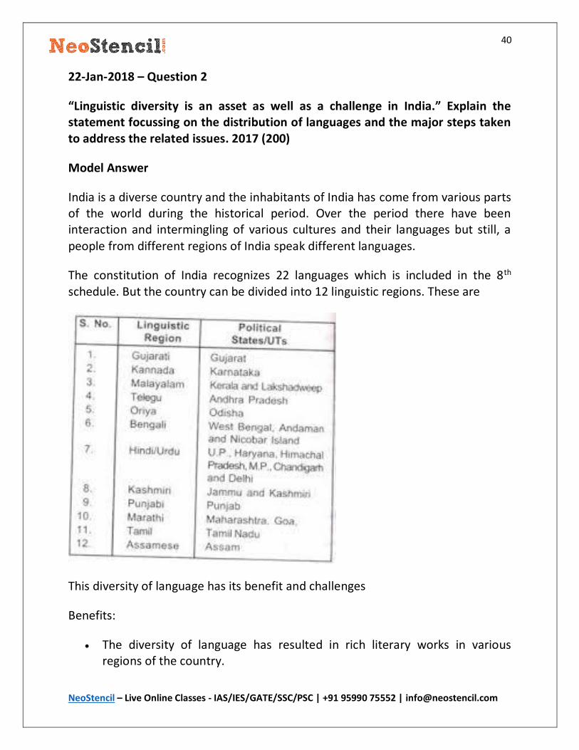
The constitution of India recognizes 22 languages which is included in the 8th schedule. But the country can be divided into 12 linguistic regions. These are
This diversity of language has its benefit and challenges
Benefits:
The diversity of language has resulted in rich literary works in various regions of the country.

41
NeoStencil – Live Online Classes - IAS/IES/GATE/SSC/PSC | +91 95990 75552 | [email protected]
It has resulted in cultural uniqueness in the different region of the country and provided India a rich cultural heritage.
Challenges
The diversity of Indian language has resulted in the conflict among the people of different languages as people speaking the same language share a sense of brotherhood and see other groups as different, with whom they do not want to share economic prosperity and political power and it leads to the demand of linguistic states in the country.
There are administrative challenges due to the diversity of language and it also resulted in internal security issues and ethnic conflict particular in the Northeastern states.
The flow of ideas and technology gets hindered as it is not easy to develop curriculums for such diverse set of languages.
In spite of the challenges, the government has taken measures to protect and flourish the linguistic diversity of the country.
The fundamental right provides protection to linguistic minorities. 22 languages have been included in the 8th scheduled list, that helps in the
development of these languages. Initial education of a child of the linguistic minority must be provided in its
own language. Official language act is a step in right direction as it would slowly and
steadily bridge the language barrier in the administrative matter.
These steps have allied the fear of linguistic domination of Hindi in the country and have allowed people to develop and prosper in their using their own
language.
42
NeoStencil – Live Online Classes - IAS/IES/GATE/SSC/PSC | +91 95990 75552 | [email protected]
24-Jan-2018 – Question 1
In population planning, the thrust of the Government has been ‘planning the population’ not ‘plan for the population’. Elaborate. 2015 (200)
Model Answer
India is the second most populous country in the world in spite of the fact that India was the first country in the world to come up will state-sponsored population planning measures. This summarizes the problem in the planning the population.
Since the start of the population planning processes in India, the thrust of the program was to control the rate of growth of population by providing cheap contraceptives, the incentive to doctors for sterilization, forced sterilization program during the emergency, advocacy program like Hum do Humare Do.
But in spite of all these effort, the problem of population growth continued and this has lead to a change in the perspective of the government and now the focus is on planning for the population.
The government has understood that development is the best contraceptive to population growth.
The focus is now on increasing the literacy rate by making compulsory education as a fundamental right. This will increase the literacy among women and also a literate person can better understand the importance of family planning and a small family, which will decrease the population growth
The focus is on improving the nutrition and health of mother and children to decrease MMR, CMR and IMR which will decrease the need for more children as there will be more choice of survival.
Schemes like Skill India will increase the employability of youth and may also lead to increase in the age of marriage for both male and female as an employed youth better understands that economic stability is required to start a family.
Thus In the long term, the prospect of India looks bright, Already we have started showing a decline in birth rate which in the coming decade will reach replacement label.
43
NeoStencil – Live Online Classes - IAS/IES/GATE/SSC/PSC | +91 95990 75552 | [email protected]
24-Jan-2018 – Question 2
Discuss the social and spatial ramificaitons of increasing longevity. 2015 (150)
Model Answer
The advances in medical science have drastically decreased the death rate in the 21st century. The average age of the population is increasing and the advanced countries have achieved an average age of 80 plus. But these countries have a low birth rate that balances the low death rate and so the population is balanced.
In India, the average longevity has increased considerably since Independence and has reached around 70, But the birth rate in India continues to be high and so the increasing longevity may have social and spatial ramification.
Social Ramification:
The cost of medical expenses will for the government. This will lead to a double dilemma for the government whether to spend money on development needs or to the medical need of the ageing population.
Out of pocket expenditure of family will increase. The increased out of pocket expenditure of family may lead to the destitution of elderly people or forcing the family to a lower living standard.
Due to the poor pension coverage in India, more and more elderly people will have to live a life of poverty unless government take an important policy decision.
It will lead to more issues of violence against the elderly population due to the family structure of India. Where elders are more dependent on their family.
Spatial Ramification
The high growth of population in India is the major cause of spatial problems, The overall growth of population will require more urban space for living including the decent quality of water, air and transport. In such a situation the increasing longevity will increase more pressure on the already stressed urban infrastructure of India. More slums and shanty houses will come up.

44
NeoStencil – Live Online Classes - IAS/IES/GATE/SSC/PSC | +91 95990 75552 | [email protected]
There will be increasing resource conflict in India between states as there will be states with a young vibrant population like Bihar and UP which will require more resource for development and on the other hand the states
like Kerala will require the resource for their older population.
Though the increase in longevity will have some problems if planned properly it can be managed to a great extent in India.
The government has already started Atal pension Yojna, such scheme will be very helpful to provide financial support in old age.
The medical system needs to be improved and health insurance needs to be promoted to fund the health issue of older people.
It will also open a set of new services for the old people related to nursing, community living etc.
The elderly with their knowledge and experience can also help in various social
sectors like education where the government has constantly failed.
45
NeoStencil – Live Online Classes - IAS/IES/GATE/SSC/PSC | +91 95990 75552 | [email protected]
26-Jan-2018 – Question 1
Mention various methods of functional classification of towns in India and explain the method applied by Asok Mitra. 2017 (250)
Model Answer
According to R.E Dickinson Functions are the driving force of city life, and influence to a very large extent its growth and morphology. It is the function of the town, rather than its size, which provides some basis of comparision.
There are three classes of method used to classify towns on the basis of function they perform.
1. Emperical or Qualitative methods: These are the initial methods of classifying towns on the basis of their function. Example, The method used by M. Aurousseau.
2. Emperical-cum-statistical method: It is a semi quantitative method and symbolizes a transition phase between the earlier empirical and later quantitive method. Example the method used by Chancy D Harris.
3. Pure statistical or quantitative Method: These are solely based on the statistical
analysis of the town and cities. Example, the method used by L.L Pownall.
Ashok Mitra, was The Registrar General of the Census of India, he attempted a comprehensive classification of all Indian Cities.
Following the classification of Harris, he divided the city function into nine groups.
The groups are :
I. Cultivation II. Agriculture Labour
III. Mining, Fishing, Forestry and Livestock IV. Household Industry V. Manufacturing
VI. Construction VII. Trade & Commerce
46
NeoStencil – Live Online Classes - IAS/IES/GATE/SSC/PSC | +91 95990 75552 | [email protected]
VIII. Transportation & Communication IX. Services
He ignored the first two groups as they are related to villages and grouped the seven industrial categories’ of workers into three broad groups:
(a) Manufacturing Town where (III+IV+V+VI) >(VII + VIII) or IX).
(b) Trade and Transport Town if (VII + VIII) > IX or (III+IV+V+VI).
(c) Service Town if (IX) > (III + IV+V+VI) or (VII + VIII).
In 1971 Ashok Mitra presented a triangular graph to classify the Indian town on a functional basis. The degree of specialization in each of the three basic groups (a, b, and c) was identified by a triangular method on a graph. The three sides of an equilateral triangle represent three groups by 100 values, the values of all the three groups are then plotted, and a point for each town within the triangle’s perpendiculars was located.
The point within the first circle shows highly diversified functions The points between first and second circle are moderately diversified The points between second and third represent specialized predominant
function The points outside the outer (third) circle show highly specialized
predominant function.
Based on this classification he classified 2462 towns/cities of India. According to his findings 83 were mining and plantation town, 496 were household industry towns, 374 were manufacturing town, 24 were construction towns, 244 were trade and commerce town, 78 were transport town and 1163 were service town.
47
NeoStencil – Live Online Classes - IAS/IES/GATE/SSC/PSC | +91 95990 75552 | [email protected]
26-Jan-2018 – Question 2
Small towns in India have problems and prospects of their own. Elaborate.
2017(150)
Model Answer
India is a developing nation and like any developing country, there is a continuous increase in its urban population. The urban population increased from 27% to 32% between 2001 and 2011. It is expected that the urban population may reach
50% by 2030 in India.
At present, the metropolitan cities in India attract the most number of migratory population from small towns and villages, as these cities provide diverse
employment opportunity, better living standards, infrastructure etc.
But the fast-paced migration to these urban centres has led to other challenges due to shear increase in the number of people migrating to these cities. There has been increased in a number of slums, the infrastructure created is unable to bear the increasing pressure.
In this context, the small towns in India present a lot of opportunities. India needs
to plan its urbanization taking in consideration the importance of small towns.
Problems of Small town
The planning process in India has mostly ignored the small towns. This has resulted in unplanned towns with haphazard construction without any consideration for the provision of roads, drainage, open space etc. The infrastructure in the small towns are poor from any standard, the road connectivity is lacking, Electricity not available as per the demand, non-existent solid waste management, lack of sanitation facility, lack of quality healthcare, very few employment opportunity etc.
But the same problem provides opportunities to convert the small towns to
growth centre and make them the next engine of urbanization for India.
These cities can be easily and economically planned to become world-class cities by improving the infrastructure. An improved infrastructure will bring new
48
NeoStencil – Live Online Classes - IAS/IES/GATE/SSC/PSC | +91 95990 75552 | [email protected]
employment opportunity. With improved facility, the migration to metropolitan cities will be checked. With decent health care and sanitation, the quality of life can be even better in the small town then the metro cities as there is less
pollution, traffic etc.
The policy makers have recently come to understand the importance of these small towns which is reflected in the schemes like JNURM, AMRUT, HRIDAY, Swatch Bharat etc. which has provision to improve the infrastructure and overall quality of living in the small towns.
49
NeoStencil – Live Online Classes - IAS/IES/GATE/SSC/PSC | +91 95990 75552 | [email protected]
05-Feb-2018 – Question 1
Describe the major tribal regions of India and their problems. 2016 (200)
Model Answer
Tribal peoples constitute 8.6 percent of India’s total population, about 104 million people according to the 2011 census. This is the largest population of the tribal people in the world.
The tribal regions of India are:
The tribes in the western Himalayan region residing in the states of Jammu and Kashmir, Himachal Pradesh, and Uttrakhand.
The Tribes in the North Eastern states of India Assam, Meghalaya, Tripura, Arunachal Pradesh, Mizoram and Nagaland. The states like Arunachal Pradesh, Meghalaya, Mizoram, and Nagaland have 90 percent of the population as tribal whereas in the remaining northeast states of Assam, Manipur, Sikkim, and Tripura, tribal peoples form between 20 and 30 percent of the population.
Another concentration lives in the hilly areas of central India (Madhya Pradesh, Orissa, and, to a lesser extent, Andhra Pradesh). The tribes also from a major portion of the population of the states of Jharkhand, West Bengal.
A smaller number of the tribal population reside in the western and the southern states of India and the union territories of Lakshadweep and the Andaman and Nicobar Islands.
The tribal population in India is facing various problems in spite of the protection provided in the constitution and various policies of the government.
Problems of tribal population in India
Loss of control over Natural Resources: The Tribal population predominantly depends on the forest and its resources for their survival but the policies of British during the colonial period and the continued policies after Independence has restricted the rights of Tribes on the use of natural resources of the forest which
has pushed them towards poverty and malnutrition.
50
NeoStencil – Live Online Classes - IAS/IES/GATE/SSC/PSC | +91 95990 75552 | [email protected]
A threat to their Culture and ways of Life: There has been a continuous encroachment of the areas previously inhabited by the Tribal population. Their interaction with the outside world and their culture has resulted in the loss of their culture and the new generation is slowly adapting to the new culture which may lead to complete extinction of their culture.
Displacement and Rehabilitation: Many development projects like Dams, Mines has lead to the displacement of Tribes from their native place and rehabilitation in a new place this completely changed their way of life, lead to their alienation and insecurities about their culture.
Lack of education: The government has not been able to make a sustainable effort to educate them and build their skills to take up alternative jobs and feel proud of their cultural practices.
Health and Nutrition: The medical facilities in the tribal areas are inadequate or non-existent due to the remote places in which they live. This has lead to many health and nutrition issues due to ignorance and continuous lack of health facilities.
The successive governments have understood the problems and have tried to address the issues. The schedule 6 has provided special provision to the administration of these areas and to involve the tribe in the administration process. The PESA act allowed the administration of local area by the tribal people. Various plants like Tribal Action Plans, Forest Right Act etc has been
designed to address the issues of tribal population of India.
51
NeoStencil – Live Online Classes - IAS/IES/GATE/SSC/PSC | +91 95990 75552 | [email protected]
05-Feb-2018 – Question 2
Examine the causes of regional disparities in economic development in India.
2016 (200)
Model Answer
The regional disparities in economic development can be observed from the per capita income of the states in India. On the one hand, we have states like Maharashtra with per capita income of 15lakh and state like Sikkim with per capita income of 13000.
Causes of regional disparities in the economic development of India.
Historical Factors: During the colonial period, cities like Bombay, Madras and Calcutta were developed by the British India government as these places had favourable conditions suitable for trade. These initial favourable conditions lead to the development of an entrepreneurial ecosystem which has continued to make these places the topmost economic destination in India.
Geographical Factor: The hilly and mountainous areas are difficult to develop as the creation of infrastructure is difficult for fast-paced economic growth and also it will affect the pristine environment of these areas. The states like Uttrakhand, Himachal Pradesh and North East are less developed precisely because of these conditions.
Locational Advantages: Some of the states in Plains have fertile lands for agriculture and some have mineral resources like Iron Ore, Coal. These factors contribute to the economic development of the areas. Cities like Jamshedpur, Dhanbad have developed because of their mineral richness. States like Punjab, Haryana developed utilizing their favourable agricultural conditions.
52
NeoStencil – Live Online Classes - IAS/IES/GATE/SSC/PSC | +91 95990 75552 | [email protected]
Institutional Support: Institutional Factors plays a dominant role in shaping the development of an area as the resources are mobilized in these areas to develop the area. Planning Commission used this mechanism to develop places like Rourkela, Bhilai, by establishing Iron and steel industries. Green revolution leads to economic development of Punjab and Haryana though similar physical conditions were available throughout the Gangetic India.
Political Factors: The political stability of a region is the foremost requirement for its development. After independence, the eastern regions have continued to face political problems due to the rise of Naxalism and the secessionist forces in the North Eastern States. This has lead to slow development of the region.
Human Factor: A skilled manpower is an important requirement for the economic development of the region. The states in South India like Kerela, Karnataka, Tamil Nadu have a better skilled human resource as compared to the Northern states of UP, Bihar etc. This has resulted in development disparities between these states.
Thus Development is a multifaceted challenge and it can only be solved by a multipronged approach. A common development model is not suitable for all the states and so the states need to be made proactive partner in the planning and development process. The establishment of NITI AYOG seems a reasonable step in the current paradigm which can help bridge the development gaps in the country.
53
NeoStencil – Live Online Classes - IAS/IES/GATE/SSC/PSC | +91 95990 75552 | [email protected]
07-Feb-2018 – Question 1
Is planning for a cluster of villages a viable option, when planning for backward
areas of the country? Discuss with suitable examples. 2015 (200)
Model Answer
Rural population in India is about 833 million as per 2011 census and the number of villages is about 6 lakh with an average population of 1000 people in each village. In such a scenario providing even the basic facility of Health, education
and infrastructure become unviable for each village.
The absence of basic facilities and infrastructure has made these villages a backward area as skilled workers in the field of health, education does not want to work in these villages. The absence of infrastructure and institutional factors do not allow industries to participate in the development process.
Planning for a cluster of the village taking 100 villages as a unit and creating all the modern facilities in these clusters is the only viable option to promote development in these backward areas.
For example, Madhya Pradesh has planned to create model village cluster for a cluster of 100 villages. This will allow serving a viable population of 50000 people and all the resources can be mobilized in this cluster to develop a viable township with Hospital, Schools, Agro-based Industries etc. This will also encourage the private sector to participate due to the economy of scale.
Thus planning for the cluster is the only solution to the backwardness of these villages. Keeping this in mind the Government of India has planned Rurban mission to develop these backward areas in the country.
54
NeoStencil – Live Online Classes - IAS/IES/GATE/SSC/PSC | +91 95990 75552 | [email protected]
07-Feb-2018 – Question 2
Explain the origin, dimension and implications of Sino-Indian border dispute. 2016 (200)
Model Answer
India and China are among the biggest economies currently dominating the global growth. Both the country are neighbours and shares thousands of Km of the border in the Himalayan region. There are border disputes due to the historical legacy which can become a flashing point and trigger a war of mammoth
dimension.
Origin of Dispute
The Sino – Indian border dispute is the legacy of colonial rule in India. The major dispute is in the western sector of Askai chin and in the eastern part of Arunachal Pradesh.
The dispute in the western sector is due to the confusion between Jonshon Line and Macartney-Macdonald Line. India considers Johnson line as final but China does not recognize Johnson line and wants India to accept Macartney Macdonald Line.
In the eastern sector, China does not recognize the McMohan Line as China has not been the party in the Shimla conference to delimit the border between Tibet and British India.
Dimension
The dimension of the dispute can only be gauged from understanding the fact that the dispute has remained unresolved even after 20 years of confidence-building measures and negotiations. In 2017 the dispute escalated to a prewar like scenario in the Doklam sector. Both the country has already fought a war in 1962 and the dispute can trigger a major global war in future if it remains unresolved.
Implication of the dispute
55
NeoStencil – Live Online Classes - IAS/IES/GATE/SSC/PSC | +91 95990 75552 | [email protected]
India and China are among the largest economy in the world, any dispute between the two is going to throw shock wave to the world economy.
Both the country are Nuclear power and any war can easily trigger a nuclear holocaust far greater in dimension than the Hiroshima- Nagasaki Nuclear holocaust.
Both the country has billions of people, a war between them will cause loss of life and property to a huge number of people far more than ever seen in the world history.
The major sector of the war will remain the Himalayan region and it will cause unimaginable loss of biodiversity in the region.
Thus any dispute between India and China can have disastrous implications both for the people living in India and China and the world community. The only solution to the problem is to have continuous negotiation and finalize the border without much changes in the historical benchmarks.
56
NeoStencil – Live Online Classes - IAS/IES/GATE/SSC/PSC | +91 95990 75552 | [email protected]
09-Feb-2018 – Question 1
How has India’s ‘Look East’ policy taken shape in the past two decades and how
it may affect India’s external trade? 2015 (200)
Model Answer
India’s Look East policy has taken birth in the changing global situation of the early 1990’s. After the disintegration of the former USSR and end of cold war, the world political and economic condition changed dramatically and it forced India to
reorient its Foreign policy to suit the changed global situation.
The Look East policy focused on increasing the engagement with East Asia and South East Asia. The main objective of the policy is to develop close economic relations with the countries of this region and to gain a better opportunity of the market, capital and technology for the rapid growth of Indian Economy.
Initially, the policy focused only on the development of trade and investment linkages with the members of the ASEAN. But now the Look East Policy has been rechristened to become Act East Policy. The Act east policy has expanded the content as well as the reach of this policy. Now the focus is not only the ASEAN but also non-ASEAN countries of East Asia. Again, besides economic relations, it is equally focused on deepening strategic relationships in the region.
The Policy has a great advantage for India’s External Trade. The linkages provide capital and technology to develop the export led the growth of the country. The market in these countries can be utilized to export Indian textile, handicraft and agriculture products which will help the growth of Indian economy. It will also help improve the competitiveness of the Indian manufacturing due to competition between the nation to control the market share.
Overall the Look East Policy has given a new dimension to India’s trade and Strategic relation which will increase the prosperity of the region and develop a sense of brotherhood between the nations.
57
NeoStencil – Live Online Classes - IAS/IES/GATE/SSC/PSC | +91 95990 75552 | [email protected]
09-Feb-2018 – Question 2
Identify the Naxal-affected areas in India and discuss their socio-economic
problems. 2017 (200)
Model Answer
The Naxal affected areas in India are predominantly the Eastern states and the central Indian states. The states are Jharkhand, West Bengal, Odisha, Chattisgarh, parts of Andhra Pradesh, Telangana, Madhya Pradesh, Uttar Pradesh and Bihar. As much as 88 districts, covering 1.2 lakh villages are under the influence of Naxalism. The earlier Prime Minister Dr Manmohan Singh has called Naxalism the greatest threat to India’s internal security but it also advocated the problem need development and socio-economic solution.
Socio-Economic problems in the Naxal affected areas:
Most of the Naxal affected areas are tribal areas and is facing the issues of poverty, unemployment, livelihood issues, low literacy and feeling of alienation. The successive governments of state and centre have not been able to resolve their issues which have alienated them from the government and they have been influenced by the ideology of Naxalism. Some of the Naxal Areas are rich in minerals and has led to the displacement of Tribal population, the displaced population has not been rehabilitated as per the promise by the government and has become a fodder for the growth of Naxal ideology. The forest administration has also contributed to the issue of Naxalism as the rights of Tribals to the forest and its resource has been curbed in the name of conservation and this has resulted in livelihood issues for tribals.
The problem of Naxal affected areas can only be solved by development efforts and outreach of the government to make the people feel that they are also the citizen of this country and they have same rights as their counterpart in any other areas of the country. The Government has already started making effort in this direction, Pradhan Mantri Gramin Sadak Yojna, Forest Right Act are steps in the right direction. These efforts along with development effort will surely make a dent on the Naxal Ideology but it will take sustained efforts for years to come.
58
NeoStencil – Live Online Classes - IAS/IES/GATE/SSC/PSC | +91 95990 75552 | [email protected]
19-Feb-2018 – Question 1
Give a reasoned account of river water disputes related to the River Krishna
Model Answer
The Krishna is the second largest river in peninsular India. It rises in the Western Ghats just to the north of Mahabaleshwar. It flows through the state of Maharashtra, Karnataka, Telangana and Andhra Pradesh before emptying in the Bay of Bengal.
The reorganization of states in India after Independence has resulted in disputes between the states for sharing of river water. Every state has its own agriculture and industrial development for which water is an important resource. To get maximum out of the pie most of the interstate flowing rivers are in a state of dispute.
Krishna River dispute is one such dispute between the four riparian state i.e Maharashtra, Karnataka, Telangana and Andhra Pradesh.
To resolve the issue of sharing of water between states, Indian constitution has
made a provision for the constitution of interstate water dispute tribunal.
Initially, Krishna river dispute tribunal was constituted in 1969 which gave its award in 1973 and the tribunal made a promise to review its order in 2000. After some delay in 2004 a new Krishna water dispute tribunal was set up and it again redistributed the water between the states considering 65 % dependability in 2010.
After the division of undivided Andhra Pradesh in Telangana and Andhra Pradesh. The two-state demanded the redistribution of the Krishna river water between the four riparian state but the plea was quashed by the KWRT II.
Still, the issue is not resolved and both the state are planning to move to the supreme court to quash the order of KWRT II.
59
NeoStencil – Live Online Classes - IAS/IES/GATE/SSC/PSC | +91 95990 75552 | [email protected]
19-Feb-2018 – Question 2
Discuss the freshwater crisis in India and prepare a blueprint for its sustainable management. 2017 (200)
Model Answer
The availability of fresh water is only 3% of the total water resource on the earth. Of this 3 % global water resource, India has only 4% of fresh water. In this 4 %, it supports 17% of the world’s population and 15 % of Livestock.
At the time of Independence, the per capita availability of water in India was 6008 cubic meter which has come down to 1540 cubic meter as per 2011 census. This is below the international threshold of 1700 cubic meter. It is estimated that by 2050 per capita availability of water will be limited to 1140 cubic meter. This shows the impending freshwater crisis which India will have to face if timely action is not taken.
Though the country is blessed with mighty rivers and monsoon rainfall of about 3 months which recharges the groundwater and other water storage structure but still India has not been able to tap its water resource which goes waste as run off and leave its population in a state of crisis.
Steps that can be taken to address the issue
India needs to invest heavily in creating water harvesting structure both in rural and urban areas to prevent the runoff of water during the monsoon.
The state has to take stringent action on industries polluting river waters. The municipalities need to recycle the used water to reuse them in
irrigation projects so that the wastage of water is reduced. Need to develop crops which require less water for its production. Measures like drip and sprinkler irrigation are required to prevent wastage
of water in Fields. Modern water law is required where Industries must recycle every drop of
water they use and there should be stringent punishment for those who violate these laws.
Even after the huge growth of population in India, we can manage the freshwater crisis if we can manage the available water resource in the country. This is the

60
NeoStencil – Live Online Classes - IAS/IES/GATE/SSC/PSC | +91 95990 75552 | [email protected]
responsibility of all the stakeholders of the society and not just the government. So we must join our hands and take a consistent effort to prevent the impending water crisis in the country.
61
NeoStencil – Live Online Classes - IAS/IES/GATE/SSC/PSC | +91 95990 75552 | [email protected]
21-Feb-2018 – Question 1
Bring out the geopolitical implications of Doklam dispute in the context of Indo-China relations. 2017 (150)
Model Answer
Doklam is situated in the tri-junction between India, China and Bhutan. The Doklam standoff started when the Chinese side tried to build a road in the disputed region. Since Bhutan is diplomatically and militarily supported by India, India supported Bhutan against the Chinese incursion and this resulted in a 75-day
military standoff between India and China.
The standoff was finally resolved after sustained negotiation and diplomacy and both sides withdrew their army from the disputed site.
The geopolitical implication of Indo-China dispute:
1. India’s strong resolve against Chinese provocation sent out a strong message to the south and south-east Asian countries that India would stand with its friend in time of crises.
2. The dispute was closely watched by the south East Asian nation who has a territorial dispute with China and now they have hope that China is not unstoppable.
3. This has raised the stature of India in the comity of the nation and now India is considered as a rising superpower.
4. The resolution of the dispute also shows that every dispute can be resolved through diplomacy and negotiation.

62
NeoStencil – Live Online Classes - IAS/IES/GATE/SSC/PSC | +91 95990 75552 | [email protected]
21-Feb-2018 – Question 2
Goods and Service Tax (GST) has differential impact on developed and backward
States of the country. How and why? 2017 (200)
Model Answer
GST is one of the greatest tax reform the country has seen since independence. The multiple tax collected by the government like service tax, excise, sales tax etc will be subsumed under GST as a single tax. This will remove the cascading effect of the tax on the economy and improve the competitiveness of the economy. Since the GST is completely automated it will improve the tax compliance and the tax to GDP ratio of India.
GST is a destination based tax which means the tax will accrue to the state where consumption of goods and services has taken place. This is different from the earlier tax system where the states involved in the manufacturing of goods and provision of services accrues all the tax benefit which improved their tax collection. The tax collection allowed these states to improve infrastructure and
social welfare and attract investment.
In GST regime the states consuming the goods and service will accrue tax and it will improve their tax collection. This will allow the backward states to improve the infrastructure and social welfare. It will also push industries to relocate in the states consuming their goods and services and it will improve the manufacturing capabilities of the back word states.
The Developed states will suffer some loss of tax due to GST which may affect their plans but the Center has committed that any loss to states due to GST will be compensated by the centre.
Thus GST will bridge the development disparity between the developed and backward state which has been a major objective of policymakers in the country.
63
NeoStencil – Live Online Classes - IAS/IES/GATE/SSC/PSC | +91 95990 75552 | [email protected]
23-Feb-2018 – Question 1
Bring out the significance of Indian Regional Navigation Satellite System (IRNSS) 2017 (200)
Model Answer
IRNSS is an independent regional navigation satellite system being developed by India. The IRNSS constellation is designed to provide navigational services to users in India and the region extending up to 1,500 km from the Indian boundaries. It will provide two types of services including Standard Positioning Service (SPS), which is provided to all the users and Restricted Service (RS), which is encrypted service provided only to the authorised users. The IRNSS System is expected to provide a position accuracy of better than 20m in the primary service area.
Significance of IRNSS
1. It will free India’s dependence on other country’s navigational satellite for civil as well as military purposes.
2. It will help the Indian defence forces to improve their operational efficiency by the improved accuracy of IRNSS.
3. During the war, India will not have to depend on other countries for GPS data. For instance, the difficulties that India had encountered while accessing the restricted services of American GPS, especially for a military application like the firing of missiles, has underscored the importance and strategic significance of an independent satellite navigation constellation.
4. India will be able to provide help to its neighbouring country during a natural disaster, as the region is quite prone to natural disaster.
IRNSS has placed India in the elite group of few nation which has their own navigation satellites. This further strengthens the position of Indias scientific and technological development and raises the stature of the country in the comity of nations.
64
NeoStencil – Live Online Classes - IAS/IES/GATE/SSC/PSC | +91 95990 75552 | [email protected]
23-Feb-2018 – Question 2
Analyze the pattern of India’s trade with the S-E Asian countries. 2016 (150)
Model Answer
India’s trade with S-E Asian countries got an initial push from the Look East policy of India in the 1990’s. The relation was given another boost recently by converting
the LEP to Act East in 2014.
India’s trade relationship has improved steadily over the past two and a half decade with the S-E Asian countries or ASEAN as the group commonly called.
India-ASEAN trade has risen to $70 billion in 2016-17 from $65 billion in 2015-16. The bilateral trade is expected to touch $200 billion by 2020. According to the industry body, Assocham, (India’s) trade deficit with ASEAN had risen from $0.5 billion in 2005-06 to $14.6 billion in 2015-16, which need to be bridged by getting more access to the ASEAN market.
ASEAN accounted for around 12.5% of investment flows into India since 2000. while FDI outflows from India to ASEAN countries, from 2007 to 2015, was $38.67
billion.
ASEAN and India also have a Free Trade Agreement (FTA) to boost investments, as well as trade in goods and services. Besides, India and ASEAN are involved in negotiations for a mega-regional FTA called the Regional Comprehensive Economic Partnership which will further improve the trade relation with S-E Asian countries.

![[Download] Sociology Optional Subject Paper 1 & 2 of UPSC Civil Service IAS IPS Mains Exam 2013 - Mrunal](https://img.pdfslide.net/doc/110x75/577cc1421a28aba711928a06/download-sociology-optional-subject-paper-1-2-of-upsc-civil-service-ias.jpg)


![[UPSC MAINS-2014] Insights Secure Mains, 01 August 2014 · [UPSC MAINS-2014] Insights Secure Mains, ... Critically evaluate the success of the South Asian Association for Regional](https://img.pdfslide.net/doc/110x75/5ada2dfe7f8b9ae1768cd560/upsc-mains-2014-insights-secure-mains-01-august-upsc-mains-2014-insights-secure.jpg)