Embed Size (px)
Citation preview
1
NeoStencil – Live Online Classes - IAS/IES/GATE/SSC/PSC | +91 95990 75552 | [email protected]
90 Days UPSC Mains Optional Answer Writing
Initiative
Geography – Paper 1
Question and Model Answers from Subject Experts
2
NeoStencil – Live Online Classes - IAS/IES/GATE/SSC/PSC | +91 95990 75552 | [email protected]
04-Dec-2017 – Question 1
What is Base Level? Explain the types of base level. (2013)
Model Answer
J W Powell was an American geologist who proposed the idea of Base Level. His
concept of the base level has been used in geomorphology and hydrology to
explain erosion by stream channels.
The base level is defined as the lowest level of land below which erosion cannot
take place. The sea level is considered to be the grand base level below which the
land cannot be eroded. We may also have a local or temporary purpose other
base levels of erosion, which are the level of the bed of principal stream carrying
the product of erosion.
There are three types of base level as explained by Powell
1. The grand base level is the sea level for subaerial erosion. Any change to
the sea level can bring change to grand base level. E.g. Submergence or
emergence of sea surface due to tectonic activity or isostatic changes.
2. The local or temporary base level. E.g. a channel may drain into a lake and
lose its erosion capacity. For this channel, the level of the lake is its base
level. Similarly, a river may encounter soft and hard bed rocks during its
course. When passing from a soft rock bed to a hard rock bed, the river
may face temporary base level in its path. Anthropogenic activity like the
building of a dam in the path of the river can also act as a local base level
for the river.
3. It is an imaginary sloping surface of a stream where erosion has practically
ceased to take place. This idea was supported by Campbell. He explained
that when the stream is in its old age the surface will constitute a
peneplane. This peneplane will approach very close to base level.
3
NeoStencil – Live Online Classes - IAS/IES/GATE/SSC/PSC | +91 95990 75552 | [email protected]
04-Dec-2017 – Question 2
“Present day landforms bear more complexity than simplicity.” Elucidate (2015)
Model Answer
The present-day landforms are the result of millions of years of geomorphological processes.
In these millions of years, the earth has been in continuous movement (as explained by plate tectonics) which gave rise to new geological structures, rejuvenation of old landforms and wiping out of existing landforms.
E.g. The convergence of Indian plate with the Asian plate lead to the development of the loftiest mountain system in the world. The glaciers piled up in these mountain systems has been the source of some of the largest river system in the world, which has shaped the landforms by various denudation and deposition processes. The rivers have created gorges, alluvial cones, and fans, Plains and deltas.
Secondly, the climate of the earth has undergone significant changes in the past
which have also shaped the landforms of the present.
E.g. The Pleistocene ice age witnessed the advancement of huge glaciers to the North European countries such as Great Britain, Denmark and Parts of Germany and caused the erosion of land surfaces which has resulted in their present landforms.
This interplay of plate tectonics and climatic changes during the course of earth
evolution gives complexity rather simplicity to the landform.

4
NeoStencil – Live Online Classes - IAS/IES/GATE/SSC/PSC | +91 95990 75552 | [email protected]
06-Dec-2017 – Question 1
State the concept of Plate Tectonics. How does it help in explaining the formation of the Himalayas and Appalachians? (2014)
Model Answer
The theory of plate tectonics was postulated by Harry Hess and his team. He based his concept of plate tectonics on the premise of Seafloor spreading and Paleomagnetism.
According to the concept of Plate Tectonics, The earth has a rigid outer layer known as Lithosphere. The lithosphere is about 100 km thick and is floating on the semi-viscous layer called Asthenosphere. Further, the Lithosphere is divided into various plates of large, medium and small dimensions. These plates are in a dynamic state relative to each other. The movement of these plates result in convergence, divergence and slipping of plates which explains various geological events like earthquake and volcanoes as well as multiple geomorphic structures on the earth crust.
Driving force: Thermal convective cells in the mental is the driving forces responsible for the dynamic state of plates.
The interaction of plates results in 3 – types of boundary :
1. The convergent Boundary 2. The divergent Boundary 3. The transform Boundary
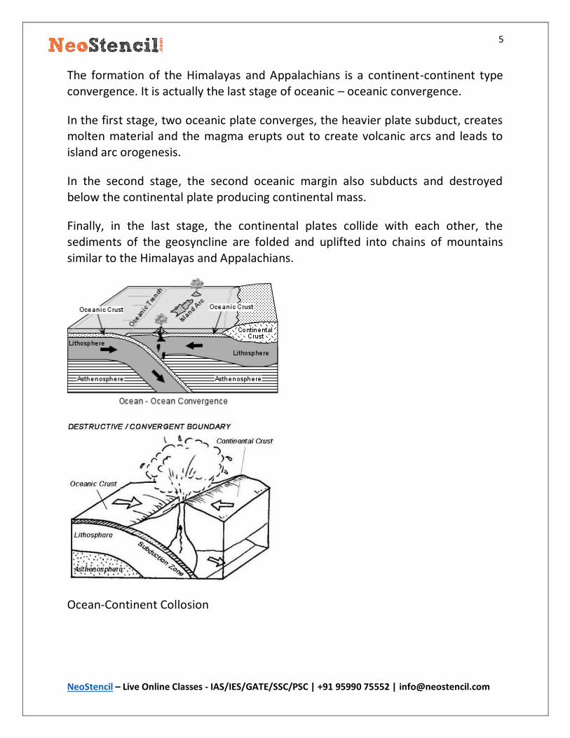
The formation of the Himalayas and Appalachians can be explained by the convergent boundary theory explained in plate tectonics.
5
NeoStencil – Live Online Classes - IAS/IES/GATE/SSC/PSC | +91 95990 75552 | [email protected]
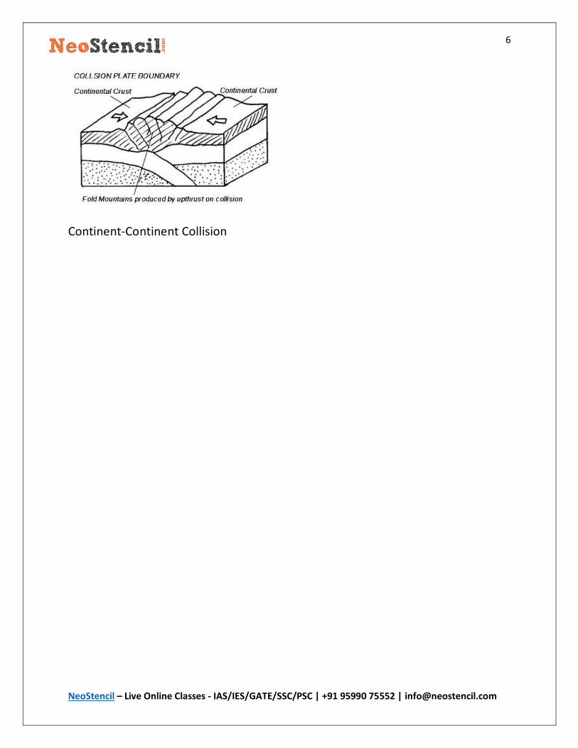
The formation of the Himalayas and Appalachians is a continent-continent type convergence. It is actually the last stage of oceanic – oceanic convergence.
In the first stage, two oceanic plate converges, the heavier plate subduct, creates molten material and the magma erupts out to create volcanic arcs and leads to island arc orogenesis.
In the second stage, the second oceanic margin also subducts and destroyed below the continental plate producing continental mass.
Finally, in the last stage, the continental plates collide with each other, the sediments of the geosyncline are folded and uplifted into chains of mountains similar to the Himalayas and Appalachians.
Ocean-Continent Collosion
6
NeoStencil – Live Online Classes - IAS/IES/GATE/SSC/PSC | +91 95990 75552 | [email protected]
Continent-Continent Collision

7
NeoStencil – Live Online Classes - IAS/IES/GATE/SSC/PSC | +91 95990 75552 | [email protected]
06-Dec-2017 – Question 2
State the concept of Erosion Surface and highlight the factors responsible for
their development. (2014)
Model Answer
Erosion surface is almost the plain topographic surfaces having undulated ground surface and the remnant of low relief cause by dynamic wheels of denudational processes, cutting across geological formations and structures. These surfaces are flat or nearly flat plains that have been formed very close to base level and is a result of cycles of erosion that have reached well beyond the stages of youth and in many instances into the stage of old age. Example of erosion surface are peneplain, pediplain, periglacial surface, etc.
The concept of erosion surface helps in understanding the historical evolution of the landscape and its present form. A study of the erosional surface gives an insight into the old denudation process and the base level of erosion. E.g The erosion surface can give an idea of the agent of denudation, the active and
passive phase of the tectonic activity, any change in the climatic factors etc.
Factors responsible for the development of erosional surface are:
The agent of denudation: Various agents of denudation such as fluvial, glacial, Aeolian leads to the formation of various types of erosional surface. E.g., Peneplain is a result of a fluvial process as explained by Davis. Periglacial erosion surface is formed by the glacial agents.
Climatic Factor: The climatic factor determines the agent of the gradation, which in turn shapes the final character of the erosional surface. Climate change in a region also affects the final erosional surface as it would lead to variation in degree as well as the initial agent of gradation.( e.g. During Pleistocene age the areas engulfed by glacier underwent glacial erosion process rather a normal fluvial process).
Tectonic Activity: The tectonic activity of the earth may impact the normal cycle of erosion and in turn affect the final erosion surface. E.g The emergence and submergence of the surface due to endogenetic forces before the completion of the cycle of erosion will result in a composite landform.
8
NeoStencil – Live Online Classes - IAS/IES/GATE/SSC/PSC | +91 95990 75552 | [email protected]
08-Dec-2017 – Question 1
Explain with examples as to how channel dynamics has been responsible for the
development of alluvial Fans and cones. (2015)
Model Answer
Channel dynamics is a function of the gradient of the channel, volume of the
channel and the velocity of the stream. The channel dynamics helps in
determining the capacity and competence of the stream.
Capacity is the total potential load of sediment which stream can carry and varies
with particle size. Competence is the weight of largest particles that the stream
can possibly move.
During the course of its journey, a river undergoes changes in channel dynamics
due to the break in the slope, widening of the valley floor, contact with quiet
water etc. These changes lead to change the carrying capacity of river and
deposition of sediments takes place.
The Fans and cones are the depositional features of a stream formed along the
foothills of the mountains or where there is a sudden change in the slope.
E.g., Alluvial fans and cones are easily visible in the Himalayan river system. The
fans formed when the Himalayan River leaves the mountain slope and enters the
low lying plane. This result in a sudden change in channel dynamics and carrying
capacity of river resulting in deposition of sediments. A cone is nothing but a type
of alluvial fan with steeper slope coarser deposits. The best example of fans is the
fans formed by river Kosi in Nepal.
10
NeoStencil – Live Online Classes - IAS/IES/GATE/SSC/PSC | +91 95990 75552 | [email protected]
08-Dec-2017 – Question 2
Geological structure has a dominant control on landform and is reflected on
them. Discuss
Model Answer
The role of the structure has been highlighted by Davis, where he defined
landforms as a function of structure, process and stage.
Thornbury also stated that the structure is the dominant control factor in the
evolution of landform.
The term geological structure has a wide connotation. It includes the composition
of the rock, its physical characteristics, the tectonic features of the rock and its
lithological characteristics.
All these factors play an important role in determining the rate of Endogenetic
and Exogenetic forces which shapes the landforms.
The tectonic features of the rock further include the slope, angle of inclination
and declination and orientation of rock. These factors influence the final shape of
landforms E.g. Layered sedimentary rocks of alternating resistance create marked
relief effects. Where the dips are almost horizontal mesas are produced. Where
the rock form is gently dipping, a cuesta form is typically produced. The
scarplands of south-east England, South Wales areas are good example cuesta.
The lithological characteristic includes the permeability, porosity, stratigraphy of
the rock. The effect of porosity and permeability can be easily visualized in the
karst region. E.g In karst region the highly permeable limestone often have very
steep slopes, Chalk slopes are frequently convex.
Structure controls the work of the agents of gradation which finally determine the
shape of landforms. The intensity of weathering and erosion in the initial
landforms of Davision cycle is weak due to the resistant nature of the structure.
Thus it can be concluded that geologic structure has dominant control over
landform and is reflected on them.
11
NeoStencil – Live Online Classes - IAS/IES/GATE/SSC/PSC | +91 95990 75552 | [email protected]
18-Dec-2017 – Question 1
Compare the origin and weather conditions associated with the tropical and
temperate cyclones. 2016 (200 words)
Model Answer
Tropical Cyclone
The condition for the origin of Tropical Cyclone:
Presence of sea surface with minimum temperature of 27 degrees C Presence of Coriolis force Presence of a preexisting vortex Existence of conventional current SALR must prevail over ELR
Whether condition
The weather conditions are violent and unpredictable. As tropical cyclone approaches pressure starts dropping, wind velocity increase from a gentle breeze to hurricane speed. With the approach of storm cirrus or cirrostratus cloud appear in the sky which then gradually thickens to cumulonimbus cloud. The weather is associated with thunder, lightning and heavy rain. Then there is sudden arrival of the central calm zone and the weather improves but this is short lived and the again the storm begins. Now the direction of the wind is reversed. Gradually the severity of storm relieves as the storm moves out.
Temperate cyclone
Origin Conditions
Temperate cyclone originates in the latitude (30 to 65) degree N-S. This cyclone has a dynamic origin. It is more prevalent in North hemisphere due to more temperature contrast. The warm air mass from tropical region interacts with the cold air mass of the polar region, which results in frontogenesis.The cyclone dissipates when the energy of interacting air mass harmonizes.
Whether condition
12
NeoStencil – Live Online Classes - IAS/IES/GATE/SSC/PSC | +91 95990 75552 | [email protected]
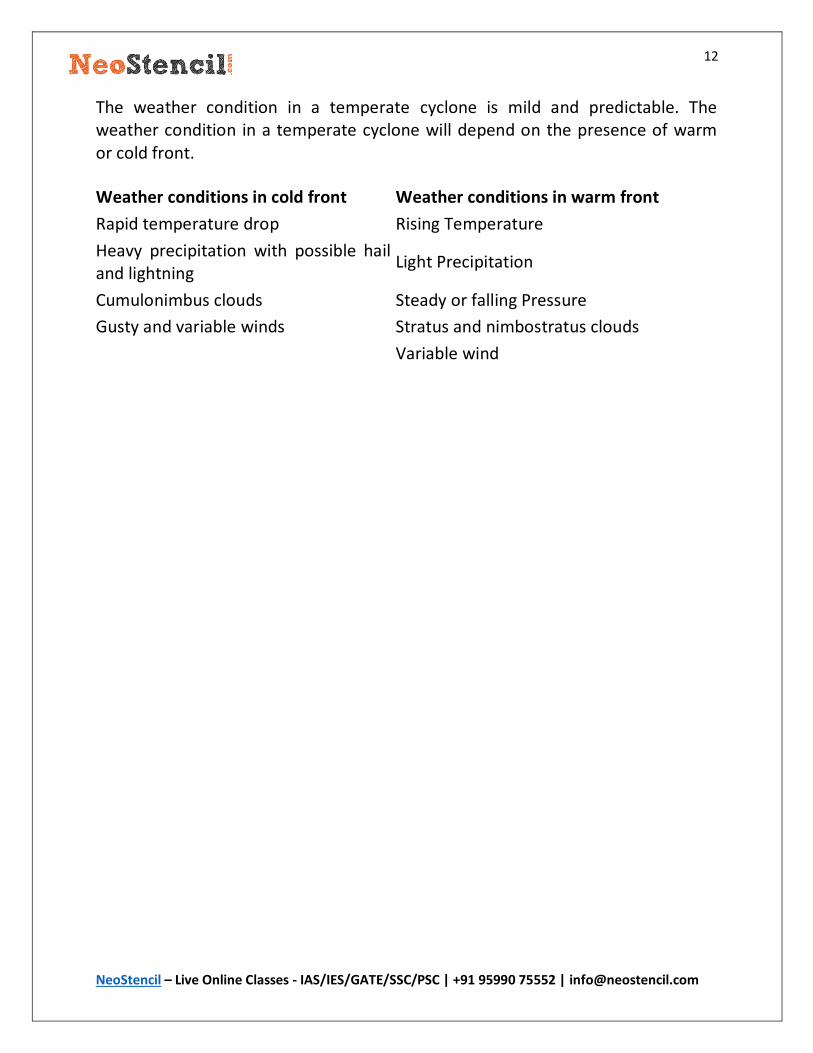
The weather condition in a temperate cyclone is mild and predictable. The weather condition in a temperate cyclone will depend on the presence of warm or cold front.
Weather conditions in cold front Weather conditions in warm front
Rapid temperature drop Rising Temperature
Heavy precipitation with possible hail and lightning
Light Precipitation
Cumulonimbus clouds Steady or falling Pressure
Gusty and variable winds Stratus and nimbostratus clouds
Variable wind
13
NeoStencil – Live Online Classes - IAS/IES/GATE/SSC/PSC | +91 95990 75552 | [email protected]
18-Dec-2017 – Question 2
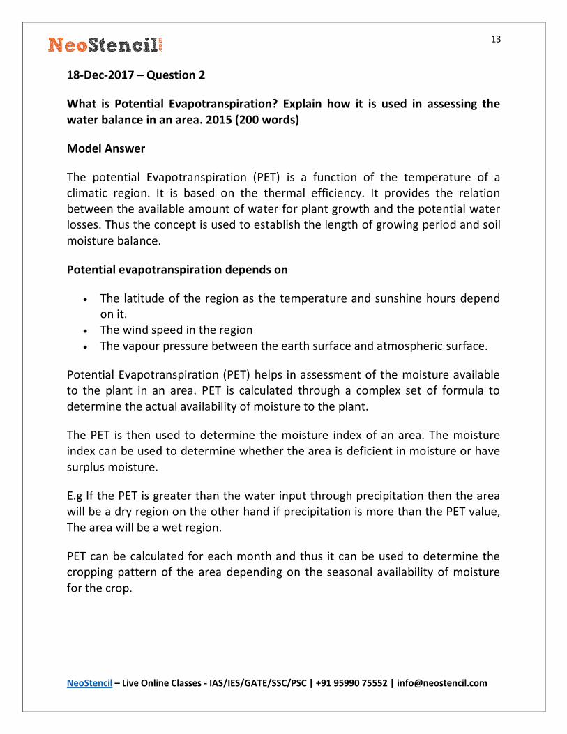
What is Potential Evapotranspiration? Explain how it is used in assessing the water balance in an area. 2015 (200 words)
Model Answer
The potential Evapotranspiration (PET) is a function of the temperature of a climatic region. It is based on the thermal efficiency. It provides the relation between the available amount of water for plant growth and the potential water losses. Thus the concept is used to establish the length of growing period and soil
moisture balance.
Potential evapotranspiration depends on
The latitude of the region as the temperature and sunshine hours depend on it.
The wind speed in the region The vapour pressure between the earth surface and atmospheric surface.
Potential Evapotranspiration (PET) helps in assessment of the moisture available to the plant in an area. PET is calculated through a complex set of formula to determine the actual availability of moisture to the plant.
The PET is then used to determine the moisture index of an area. The moisture index can be used to determine whether the area is deficient in moisture or have surplus moisture.
E.g If the PET is greater than the water input through precipitation then the area will be a dry region on the other hand if precipitation is more than the PET value, The area will be a wet region.
PET can be calculated for each month and thus it can be used to determine the cropping pattern of the area depending on the seasonal availability of moisture for the crop.
14
NeoStencil – Live Online Classes - IAS/IES/GATE/SSC/PSC | +91 95990 75552 | [email protected]
20-Dec-2017 – Question 1
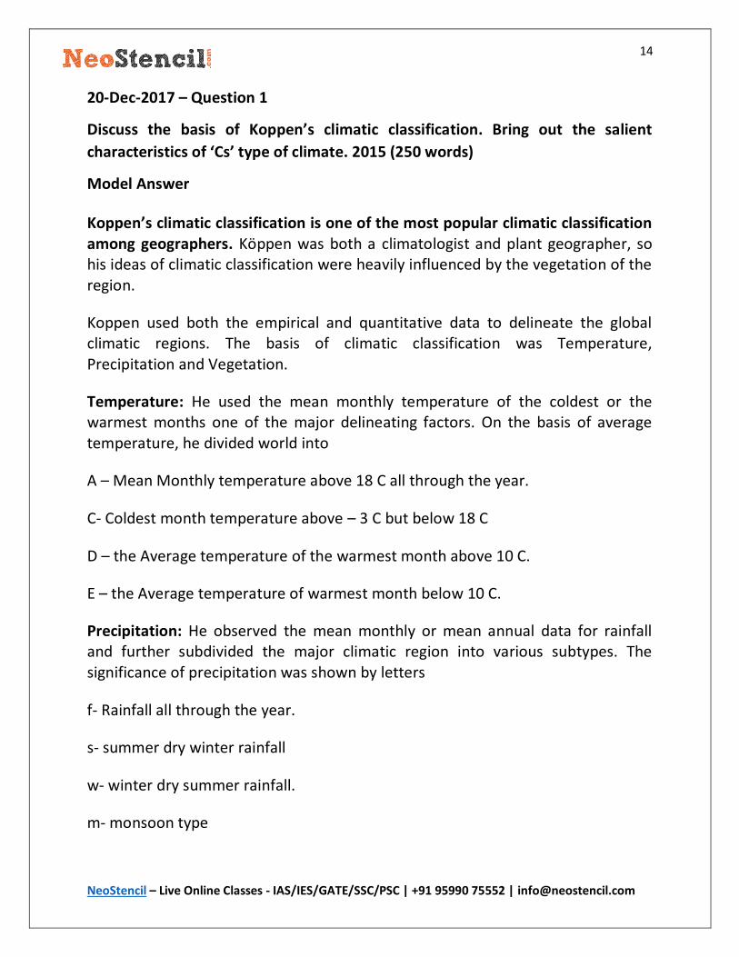
Discuss the basis of Koppen’s climatic classification. Bring out the salient
characteristics of ‘Cs’ type of climate. 2015 (250 words)
Model Answer
Koppen’s climatic classification is one of the most popular climatic classification among geographers. Köppen was both a climatologist and plant geographer, so his ideas of climatic classification were heavily influenced by the vegetation of the region.
Koppen used both the empirical and quantitative data to delineate the global climatic regions. The basis of climatic classification was Temperature, Precipitation and Vegetation.
Temperature: He used the mean monthly temperature of the coldest or the warmest months one of the major delineating factors. On the basis of average temperature, he divided world into
A – Mean Monthly temperature above 18 C all through the year.
C- Coldest month temperature above – 3 C but below 18 C
D – the Average temperature of the warmest month above 10 C.
E – the Average temperature of warmest month below 10 C.
Precipitation: He observed the mean monthly or mean annual data for rainfall and further subdivided the major climatic region into various subtypes. The significance of precipitation was shown by letters
f- Rainfall all through the year.
s- summer dry winter rainfall
w- winter dry summer rainfall.
m- monsoon type

15
NeoStencil – Live Online Classes - IAS/IES/GATE/SSC/PSC | +91 95990 75552 | [email protected]
The ratio of evaporation and precipitation was also used to demarcate regions of B type climate.
Vegetation: Koppen’s classification was influenced by vegetation as he considered vegetation as the sum total of a climatic region and thus his climatic boundaries match with the major biomes of the world.
C Type Climate: Mild, humid (mesothermal) climates – The coldest month has an average temperature of under 18°C, but above -3 C; at least one month has an average temperature above 10°C. The C climates thus have both a summer and a winter.
Cs Type Climate: This type of climate has warm dry summer due to the presence of subtropical high-pressure belts and rainy winter season due to the westerly wind and extratropical cyclone. This type of climate is found in the region around Mediterranean sea and in the USA. The average annual precipitation is 90 cm. The
climate is ideal for citrus fruits and suitable for the wine industry.
16
NeoStencil – Live Online Classes - IAS/IES/GATE/SSC/PSC | +91 95990 75552 | [email protected]
20-Dec-2017 – Question 2
Describe the origin and development of thunderstorms with examples. 2014
(200 words)
Model Answer
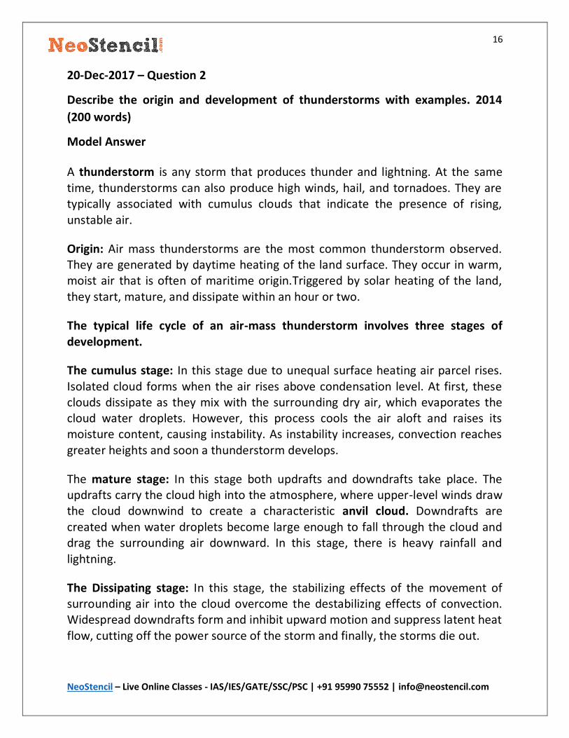
A thunderstorm is any storm that produces thunder and lightning. At the same time, thunderstorms can also produce high winds, hail, and tornadoes. They are typically associated with cumulus clouds that indicate the presence of rising, unstable air.
Origin: Air mass thunderstorms are the most common thunderstorm observed. They are generated by daytime heating of the land surface. They occur in warm, moist air that is often of maritime origin.Triggered by solar heating of the land, they start, mature, and dissipate within an hour or two.
The typical life cycle of an air-mass thunderstorm involves three stages of development.
The cumulus stage: In this stage due to unequal surface heating air parcel rises. Isolated cloud forms when the air rises above condensation level. At first, these clouds dissipate as they mix with the surrounding dry air, which evaporates the cloud water droplets. However, this process cools the air aloft and raises its moisture content, causing instability. As instability increases, convection reaches greater heights and soon a thunderstorm develops.
The mature stage: In this stage both updrafts and downdrafts take place. The updrafts carry the cloud high into the atmosphere, where upper-level winds draw the cloud downwind to create a characteristic anvil cloud. Downdrafts are created when water droplets become large enough to fall through the cloud and drag the surrounding air downward. In this stage, there is heavy rainfall and lightning.
The Dissipating stage: In this stage, the stabilizing effects of the movement of surrounding air into the cloud overcome the destabilizing effects of convection. Widespread downdrafts form and inhibit upward motion and suppress latent heat flow, cutting off the power source of the storm and finally, the storms die out.

17
NeoStencil – Live Online Classes - IAS/IES/GATE/SSC/PSC | +91 95990 75552 | [email protected]
Examples:
The thunderstorm is a daily occurrence in the month of April – May in eastern India. It is popularly known as kaal baishek in the region. Due to intense heating in during the day, clouds develop and rainfalls in the evening giving respite from summer.
18
NeoStencil – Live Online Classes - IAS/IES/GATE/SSC/PSC | +91 95990 75552 | [email protected]
22-Dec-2017 – Question 1
Discuss the nature and origin of Indian monsoon and recent techniques of its prediction. 2014 (250)
Model Answer
Monsoon is defined as the seasonal reversal of wind over the Indian subcontinent caused by the apparent shift of the sun and characterized by the rain-bearing system, oscillation of ITCZ, Break and burst.
The nature of Indian Monsoon
An approximately 180º change in the direction of winds between summer and winter.
Rainy summer and dry winter. Break and Burst during monsoon.
The origin and Mechanism of Indian Monsoon.
The phenomenon of monsoon is complex and still, attempts are going on to understand this completely. Some of the most trusted and accepted theories which explain the origin and mechanism are
1 Shifting of ITCZ over Tropic of Cancer:
During summer solstice sun’s rays are vertical over the Tropic of Cancer. Therefore, all wind and pressure belts of the globe shift towards the north. At this point of time, ITCZ shifts northwards and becomes NITCZ (Northern Inter Tropical Convergence Zone). It extends up to 30º N Latitude in South and South-East Asia. The excessive heating of Indian sub-continent further intensifies this process. According to Flohn, at this point in time, the equatorial westerlies of doldrums shift northward and get extended as southwest monsoon winds. Some other scholars consider south-west monsoon winds as an extension of south-east trade winds of southern hemisphere towards NITCZ. They become south-westerly under the influence of Coriolis force as they cross the equator. NITCZ also result in tropical disturbances which play the significant role in surface weather conditions. Heavy rainfall is received during summer and the season become the south-west monsoon.
19
NeoStencil – Live Online Classes - IAS/IES/GATE/SSC/PSC | +91 95990 75552 | [email protected]
2 The heating of Tibetan Pleatue:
In the summer season, the Tibetan Plateau gets heated and acts as a high altitude heat source which produces a thermal anticyclone over this region (in the upper atmosphere). This anti-cyclone weakens the westerly sub-tropical jet stream south of the Himalayas, and gives rise to the tropical easterly jet stream at 80º E longitude and intensifies the high-pressure cell over the Indian Ocean. Thus a surface pressure gradient is produced from the Indian Ocean towards India and it activates south-west monsoon.
3 El Nino and Southern Oscillation:
Sir Gilbert Walker in 1920 noticed that when the pressure was high over equatorial south Indian Ocean, it was low over the equatorial south Pacific and vice-versa. This pressure variation gives rise to circulation along the equator known as Walker Circulation. The pressure variation is stated as Southern Oscillation Index (SOI) and it is measured as the difference in pressure between Tahiti in French Polynesia and Port Darwin in northern Australia, representing the Indian Ocean. During an El Nino year, the SOI Index is negative i.e. pressure at Port Darwin exceeds that at Tahiti. When there is low pressure over the Indian Ocean in winter months, it indicates the chances of the following monsoon being good. But in an El Nino year the SOI being negative, India receives a lesser amount of rainfall from southwest monsoon.
Recent technique in prediction of monsoon
The phenomenon of Monsoon is very important from the socio-economic point of view of the country. So its prediction has been very important. IMD has been using the regression model to predict monsoon over the years. But recently a dynamic model has been developed to predict monsoon. In this model, simulation is used to extrapolate the data obtained from various metrological station to a particular time frame. But still the technique is not full proof and so IMD has been providing predictions from both the models and using a coupled model forecast for Monsoon.

20
NeoStencil – Live Online Classes - IAS/IES/GATE/SSC/PSC | +91 95990 75552 | [email protected]
22-Dec-2017 – Question 2
Explain the meriodional circulation of the atmosphere and its importance in world climate. 2015 (200 words)
Model Answer
The tricellular model explains the meridional circulation of the atmosphere. According to this model, the global air circulation can be divided into three cells. These cells have been divided based on the thermal and dynamic factors associated with the global air circulation.
1 Hadley cell: The cell is located between 10 – 30-degree latitude in both the hemisphere. This is a thermally induced cell and is the result of intense solar insolation. The intense insolation produces rising air along the equator. The rising air cools down below tropopause and diverges towards the pole as anti-trade. They lead to upper air pilation around 30 degrees latitude and sink causing the sub-tropical high pressure. The trade wind flows from this HP toward the equator and completes this cell. It is one of the most permanent cells and is associated with Tropical monsoon climate and tropical desert.
2 Ferrell Cell: This cell extends from 35 to 60-degree latitude in both the hemisphere. This is a thermally indirect cell and induced due to dynamic forces. In this cell the warm air is seen ascending from the polar front and breaking through near the tropopause. The most important feature of this cell is that the polar front is more continuous in the middle troposphere. There is subsidence of air in the horse latitude from the tropical as well as polar front dells. On the surface, the circulation is completed by the westerly wind flowing toward the poleward side.
3 Polar cell: It extends from 65 to 90 degree in both the hemisphere. This is a thermally direct cell and is strongest during winter. There is sinking air along the poles which moves towards the subpolar low as easterly wind. In the subpolar lows, the easterly and westerly interact and the air rise to complete the polar cell circulation.
Meridional circulation plays an important role in world climate:
21
NeoStencil – Live Online Classes - IAS/IES/GATE/SSC/PSC | +91 95990 75552 | [email protected]
1. They maintain the heat balance throughout the globe by transferring energy from high energy tropical areas to low energy polar areas.
2. The interaction of easterly and westerly creates frontogenesis which influences the climate of the subpolar area.
3. The tropical deserts of the world are a manifestation of the air circulation of the Hadley cell.
4. The Phenomenon of monsoon is heavily influenced by the Upper air circulation and the trade wind movement.
Thus meridional circulation plays an important part in global climate and its understanding.
22
NeoStencil – Live Online Classes - IAS/IES/GATE/SSC/PSC | +91 95990 75552 | [email protected]
01-Jan-2018 – Question 1
Describe the configuration of the Pacific Ocean floor. 2017 (200)
Model Answer
The Pacific ocean is the largest ocean and covers 1/3rd of the area of the earth. It extends from Asia in the west to America in the east and Bering Strait in the north to cape Adre in South.
The configuration of Pacific Ocean floor.
1. Continental Shelf: The continental self of Pacific ocean is broad in the west and narrow in the west section. Various Islands such as Kuriles, Japenese Islands, Philippines and inland seas like Bearing, java sea, coral sea etc are situated on the continental shelf.
2. Ridges: Pacific ocean does not have central ridge but a few submarine ridge dotted here and there.
In the eastern section lies the Albatross plateau. It is quite extensive and spread from central America in the north to Antartica in the south. It has a breadth of 1000 miles.
The most important rise in the central Pacific is the Hawaiian swell. The water here is only 2000m deep. On this ridge lies the island of Hawaii and Honolulu.
In the western part, the ocean has a depth of 3000m which extend from Japan to Antartica. Though there is no single ridge few mounts and raises could be found. Example Chatham rise, South Tasmania Ridge etc.
3. Basins: Many basins are found in Pacific separated by numerous swells. Some of the important basins are Aleutian Basin, Philiphine basin Fiji Basin etc.
4. Deeps: Most of the deeps of pacific ocean are found in the Trenches parallel to Island arc or the mountain chain. The deeps are mostly located in the western part of the ocean. Some of the important trenches are Aleutian Trench (avg depth 6000m), Kurile Trench (avg depth 8000m), Nero Deep is more than 9000m deep etc.
5. Marginal Sea: Most of the marginal seas are located in the western part of the ocean. Some of the important marginal seas are Bearing Sea of Japan,

23
NeoStencil – Live Online Classes - IAS/IES/GATE/SSC/PSC | +91 95990 75552 | [email protected]
Banda Sea etc. in the eastern side only a shallow Gulf of California and submerged coastal seas near British Columbia.
24
NeoStencil – Live Online Classes - IAS/IES/GATE/SSC/PSC | +91 95990 75552 | [email protected]
01-Jan-2018 – Question 2
“The relationship between the winds and the currents is best seen in the Indian
Ocean.” Justify.(2016) (200)
Model Answer
The Indian Ocean is a unique ocean as it is partially closed from the North by the continental mass. The nature of the monsoon in the Indian subcontinent greatly influence the currents in the Indian Ocean and no permanent current is found in
the north part of Indian Ocean.
During the summers, the monsoon originates from 10 degrees south and affects the Equatorial current. During the Monsoon Northeast trade wind is absent and so no N. Equatorial current is produced. The South Equatorial Current and Counter Equatorial current is drifted south by 10 degrees latitude towards the south. South Westerly monsoon generates SW monsoon drift which is clockwise circulation. The offshore movement of SW monsoon wind creates an upwelling zone on the west coast of Africa which again strengthens the SW monsoon drift.
During the winters the North East trade and NE monsoon prevails. This condition brings back the normal condition. The whole current in the northern circulation gets reversed that is the movement becomes anticlockwise. The Equatorial
current comes back and the Somalian cold current disappears.
Such a complete reversal of current with the change of season in the Indian Ocean clearly establishes the relation between Wind and the Ocean Current.
25
NeoStencil – Live Online Classes - IAS/IES/GATE/SSC/PSC | +91 95990 75552 | [email protected]
03-Jan-2018 – Question 1
Compare the Subsidence and Glacial control theories on the formation of coral
reefs. 2014 (250)
Model Answer
Coral Reefs are the most diverse marine ecosystems formed by the deposition of
calcium carbonate by the coral polyps, a marine anemone that lives in the
symbiotic relationship with algae which provide nutrition to coral polyps. These
are the important surface feature of topography found attached to submarine
platforms.
Various theories have been put forward to understand the formation of the coral
reef but still, some gap has remained incomplete understanding of coral reefs.
Comparison of the subsidence and Glacial control theories on the formation of
coral reef.
1. The subsidence theory of reef formation is postulated by Davis in
which he emphasized on the subsidence of the land for the
development of different types of coral reefs whereas the Glacial
control theory put forward by Daly gave importance to the changing
sea level and the wave cut platform formed in the Pleistocene age for
the formation of different types of coral reefs.
2. Subsidence theory explains different types of coral reefs as the
different stage in the evolution of coral reef. The stages being
Fringing reef then barrier reef and atoll being the last stage whereas
Daly considers them distinct and each formed with different sets of
the initial condition. Fringing reef formed on narrow platforms,
barrier reef formed on broad platform and atolls formed on isolated
submarine plateau eroded at the time of lowered sea level.
3. The formation of lagoons has been explained as a stage in subsidence
theory and its shallow depth to the deposition of the sediments
whereas Daly’s theory attributes the uniform lowering of sea level
and rapid growth of corals on the margins as the condition for the
formation of lagoons.

26
NeoStencil – Live Online Classes - IAS/IES/GATE/SSC/PSC | +91 95990 75552 | [email protected]
4. The presence of the barrier reef and the fringing reef on the same
Island could not be explained by subsidence theory whereas it can be
easily explained by Daly’s theory.
5. The variation in depth of the lagoons could not be explained by the
Daly’s theory whereas subsidence theory can explain the same with
ease.
Though both the theories have differences and could not explain all the aspect of
coral reefs together they can explain most of the coral reefs. Thus both the
theories are complementary to each other.
27
NeoStencil – Live Online Classes - IAS/IES/GATE/SSC/PSC | +91 95990 75552 | [email protected]
03-Jan-2018 – Question 2
Describe the characteristics of different types of pelagic deposits. 2015 (150)
Model Answer
Murray classified the ocean deposits on the basis of the area they are found, commonly known as terrigenous and pelagic deposits.
Pelagic deposits are mainly formed of skeletons, shells and some inorganic substances, found in the deep sea. These are light in colour and fine-grained deposits.
Types of Pelagic deposit:
Oozes: These pelagic deposits are in the form of liquid mud. They are basically of two types calcareous and siliceous in nature. Calcareous is further divided into Pteropod and Globigerian and are found up to 1000 fathom. Siliceous oozes are divided into Radiolarian and diatom which are found in the deep sea.
Red Clay: It is one of the most widely spread pelagic deposit. It consists of silicates of aluminium and oxides of iron.
Extra – Terrestrial Matter: These are deposits formed due to the fall of meteoric dust in the open ocean which gets deposited on the ocean floor. They are rich in oxides of iron and are important for scientific investigation.
28
NeoStencil – Live Online Classes - IAS/IES/GATE/SSC/PSC | +91 95990 75552 | [email protected]
05-Jan-2018 – Question 1
Distinguish between the characteristics of Chernozem and Sierozem soils. 2017
(200)
Model Answer
Chernozem and Sierozem are soils of sub-humid to dry climatic conditions. They are classified as Pedocals by Marbut in the genetic soil classification. They are the result of calcification of the soil horizon. But there are some differences also
Differences between Chernozem and Sierozem:
Chernozem Sierozem
Found in the Temperate Grassland like
Steppe or Prairie.
Found in the desertic and semi-
desertic areas in subtropical countries.
The Humus content is not more than
10 % in the soil composition.
Being soil of desertic condition the
humus is very low to non-existent.
The soil is dark in colour due to the
base-rich Matrix. The soil has brownish grey colour.
Capillary action is less due to better
moisture balance. Calcium layer is
found deep within the soil profile.
Capillary action well developed and it
has led to deposition of lime and
gypsum near to surface.
The soil is good for agriculture activity
and has extensive agriculture in the
area of chernozem.
The soil is fertile and can support
agriculture if irrigation facility is
available.
29
NeoStencil – Live Online Classes - IAS/IES/GATE/SSC/PSC | +91 95990 75552 | [email protected]
05-Jan-2018 – Question 2
Classify soils based on their zonal distribution and describe the characteristics of
pedocals. 2015 (200)
Model Answer
Soil refers to the upper sedimentary layer of the earth crust which has the capability to sustain vegetation on it. It is a combination of various organic and inorganic matter with associated moisture.
The genetic classification of soil by Marbut is the most suitable classification for Geographers. He recognized a strong relationship between climate, Vegetation and Soil throughout the world. The three main class of soil recognized are Zonal, Intrazonal and Azonal.
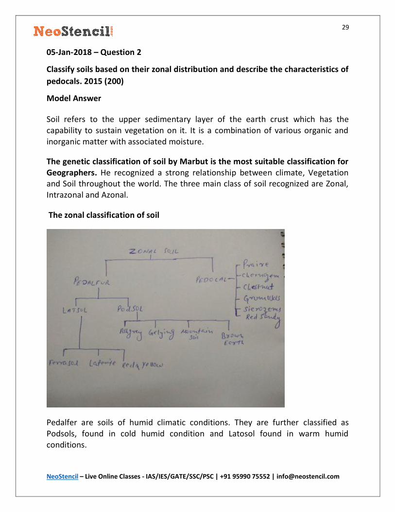
The zonal classification of soil
Pedalfer are soils of humid climatic conditions. They are further classified as Podsols, found in cold humid condition and Latosol found in warm humid conditions.
30
NeoStencil – Live Online Classes - IAS/IES/GATE/SSC/PSC | +91 95990 75552 | [email protected]
Characteristics of Pedocals
Pedocals are soils of sub-humid to dry condition. They are classified into Chernozem, Chestnut, Prairie, sierozem, grumusols and sandy soil.
1. Chernozem, Chestnut and Prairie soil: Chernozems are found in association with steppe or prairie vegetation. These soil are rich in calcium and poor in organic material. Chestnut is found in the arid side of chernozem and Prairie on the wet side of chernozem.
2. Sierozems: These can be regarded as an extreme form of chestnut soil and occur in desertic and semi-desertic condition. The lime and gypsum may come near to surface due to capillary action. They have low organic content.
3. Grumusols: these are dark clayey soils found in savanna region having a wet and dry climate. They are rich in base and develops crack in dry
season.

31
NeoStencil – Live Online Classes - IAS/IES/GATE/SSC/PSC | +91 95990 75552 | [email protected]
15-Jan-2018 – Question 1
Bring out the various ecological problems associated with the exploitation and
use of oceans and their resources. 2016 (250)
Model Answer
The ocean is one of Earth’s most valuable natural resources. It is an important source of seafood and provides food security to millions of people. It is used as a means of transport and communication and is the major source of bulk transportation. It provides a source of recreation for humans. It is mined for minerals and drilled for crude oil.
Being such an important resource, there has been exploitation of its resource to fulfil the demand of society. But in recent years due to the massive increase in the population and their development needs the resources of an ocean is being exploited in an unsustainable manner.
Ecological problems associated with the exploitation of ocean resource.
Marine Pollution: Marine pollution has become an important concern particularly for the Island nations and people living in the coastal areas. The major source of marine pollution is the disposal of untreated municipal and industrial waste. Oil spills, mining of minerals and crude oil are also an important source of marine pollution. The pollution leads to loss of biodiversity, deterioration in the quality of fish causing a loss of livelihood for local fisherman etc.
Over fishing: The increasing demand for fish in the global market has led to the use of deep trawling and modern fishing equipment. This has led to overfishing which is causing a threat to the sustainability of the various species of fishes.
Coral bleaching: Coral is a most important marine ecosystem, but the increase in pollution in the ocean due to mining of calcium from coral reefs, disposal of warm ocean water or industrial waste and unbridled tourism cause death of the corals
and leads to coral bleaching.
Eutrophication: The disposal of untreated waste or runoff from the local streams cause algae bloom and lead to the death of marine life.

32
NeoStencil – Live Online Classes - IAS/IES/GATE/SSC/PSC | +91 95990 75552 | [email protected]
Ocean desert: The increasing pollution may also lead to the expansion of ocean deserts. The mining of metallic nodules can trigger the expansion of ocean deserts.
Thus there is a need to use the resources of the ocean in a sustainable manner so as to minimize the damage already done. The concept of blue revolution to utilize the ocean resources sustainably must be adopted by the countries so that we
meet the demand of the society without damaging the ocean resource.
33
NeoStencil – Live Online Classes - IAS/IES/GATE/SSC/PSC | +91 95990 75552 | [email protected]
15-Jan-2018 – Question 2
Give a reasoned account on how the impact of Global Warming differs from one
part of the Earth to the other. 2015 (200)
Model Answer
Global Warming is a reality today and we are witnessing its effect on our generation. The development activity by the human’s post-industrial revolution has resulted in increasing the number of greenhouse gases in the atmosphere which has resulted in rising of the temperature. The globe is witnessing various changes due to the global warming.
Impact in different parts of the world:
Equatorial Region:
The rise in the temperature will lead to intensive conventional rainfall and will disrupt the lives of people and habitat of the living organism in the regions. The region may see a rise in water level and submergence of some of the island nation.The region is already inhabited by poor countries which will cause more health and nutrition issues.
Tropical region
There will be the rise in average temperature of the tropical region. Duration of summer will increase and winter will decrease. There will be an intensification of cyclonic activity, increase in the vulnerability of population due to the variability of rainfall in the region. The cropping pattern will change. The coastal regions will submerge and cause a loss of livelihood for the people in coastal areas. The deserts in the tropical region will witness extreme temperature making the area
inhospitable to the human being.
Temperate region
The rise in temperature in the temperate region will increase the agricultural area particularly in northern Europe and continental Russia. There will be the impact on the habitat of the plants and animal and there will be large-scale migration.
34
NeoStencil – Live Online Classes - IAS/IES/GATE/SSC/PSC | +91 95990 75552 | [email protected]
The burden of diseases in the region will increase due to the rise in temperature. Intensification of the extratropical cyclone.
Polar Region
The polar region will see the melting of ice in huge scale. This will lead to the large-scale change in the climatic condition as the Polar Regions maintains the global climate balance. The sea level may rise. The artic may see a rise in the mining of petroleum and natural gas which may start new settlements in the areas. The region may also see the growth of some crops. The most affected will be the polar animals who may see extinction due to these changes.
Overall the impact will be negative for the world community and so the global community have to take a concentrated effort to tackle the problem. International initiative like Paris climate deals, International solar alliance etc are the efforts in the right direction and must be pursued with utmost commitment
35
NeoStencil – Live Online Classes - IAS/IES/GATE/SSC/PSC | +91 95990 75552 | [email protected]
17-Jan-2018 – Question 1
Describe Newbigin’s scheme of Floristic regions of the world and explain the Mediterranean Floristic region. 2016 (200)
Model Answer
The geological evolution of the earth combined with the climatic variation has led to the evolution of different biogeographic regions of the world. Today’s continental distribution has come about after millions of years of tectonic movements and in this course of distribution, the endemic flora and fauna of different part of the world have evolved to give rise to different variations. Various scholars of geography and botany tried to classify this flora and fauna into certain groups.
Newbigin classified the world into five floristic regions these are:
Northern Land (Holarctic): This region includes includes the temperate to Arctic portions of North America and Eurasia. Its flora is inherited from the ancient supercontinent of Laurasia. Some of the endemic species of flora found in the region are Theaceae, Salicaceae, Brassicaceae, Ericaceae, etc.
Mediterranean: The Mediterranean region covers a portion of three continents Europe, Asia and Africa. The region is characterized by hot and dry summer and wet winter. It is home to a number of plant communities, which vary with rainfall, elevation, latitude, and soils.
Scrublands occur in the driest areas, especially areas near the seacoast where wind and salt spray are frequent. These are characterized by low and soft leaf scrubs.
Shrublands are dense thickets of evergreen sclerophyll shrubs and small trees and are the most common plant community around the Mediterranean. In some places shrublands are the mature vegetation type, and in other places the result of degradation of former forest or woodland by logging or overgrazing, or disturbance by major fires.
Grassland occur around the Mediterranean, usually dominated by annual grasses.
36
NeoStencil – Live Online Classes - IAS/IES/GATE/SSC/PSC | +91 95990 75552 | [email protected]
Woodlands are usually dominated by oak and pine, mixed with other sclerophyll and coniferous trees.
Mediterranean forests are generally composed of evergreen trees, predominantly oak and pine. At higher elevations Mediterranean forests transition to mixed broadleaf and tall conifer forests similar to temperate zone forests.
Some of the endemic species prominent in the Mediterranean vegetation are the Aleppo pine, stone pine, Mediterranean cypress, bay laurel etc.
Paleotropical Desert: The floristic region is comprising of tropical area of Africa, Asia and Oceania (excluding Australia and New Zealand). This region is characterized by hot and dry climate and this has lead to evolution of xerophytic species. Some of the endemic species in this region are Nepenthaceae, Musaceae, Pandanaceae and Flagellariaceae etc.
Intertropical: The region includes the tropical terrestrial ecoregions of the Americas and the entire South American temperate zone. This region is characterized by the broad leave Amazonian rain forest, The grassland of the Brazilian plateau. Some of the endemic species
are Caryocaraceae, Pellicieraceae, Quiinaceae, Peridiscaceae, Bixaceae etc.
Austral: The flora of Australia has evolved independently of other regions. After its separation from the Gondwana land, the species in this region evolved independently and acquired characteristics unique to this region. Woodlands of Eucalyptus cover much of the eastern third of the continent. About 19 families and 500 genera are endemic in this region.
37
NeoStencil – Live Online Classes - IAS/IES/GATE/SSC/PSC | +91 95990 75552 | [email protected]
17-Jan-2018 – Question 2
Discuss the relevance of ‘Stop and Go Determinism’ in the present day context.
2015 (200)
Model Answer
The concept of Neo – determinism was put forward by Griffith Taylor. In his assessment of the agricultural settlement in Australia, he put forward his idea that physical environment sets a broad limit and man should work within the limit
set by the environment.
He explained that man at best can accelerate or decelerate the rate of progress. He is like the traffic controller in a large city, who alters the rate, not the direction of progress; and perhaps the phrase ‘Stop-and-Go Determinism’ expresses succinctly the writer’s geographical philosophy.
Stop and Go determinism has become quite relevant in the present day context:
The unabated use of the earth’s resource to fulfil the greed of human society has led to the various problem.
Since the dawn of the industrial revolution, man has been continuously using fossil fuel for the development of human society. The fossil fuel produces greenhouse gases far in excess of the rate at which environment can recycle it. This has lead to the excess of greenhouse gas and the consequent global warming. Off late man has come in term with the stop and go determinism. The recent Paris climate deal, International solar alliance etc are the result of this understanding.
The growth of world population has put pressure on the land resource of the earth. Scientists earlier used fertilizers and other chemicals to increase the food production but this led to land degradation. The use of irrigation in the Indra Gandhi command region for agriculture is an important example that supports the idea of stop and go determinism of Taylor. The scientific community of the world has come in terms with the concept and now the focus is on the
development that is in harmony with the physical environment.

38
NeoStencil – Live Online Classes - IAS/IES/GATE/SSC/PSC | +91 95990 75552 | [email protected]
The stop and go determinism has become the most important paradigm of development world over in the present society. The man has finally understood their limitation and they are now trying to live sustainably with the environment.
39
NeoStencil – Live Online Classes - IAS/IES/GATE/SSC/PSC | +91 95990 75552 | [email protected]
19-Jan-2018 – Question 1
“There is a rejuvenation of environmentalism as a paradigm in geographical
studies.” Comment. 2015 (250)
Model Answer
Environmentalism focuses to improve and protect the quality of the natural environment from harmful human activity, through the adoption of a political, economic and social organization that is thought to be necessary for benign
treatment of the environment.
Environmentalism of 1960’s and 70’s was generally pessimistic reflecting a pervasive sense of civilization malice.
Work such as Rachel Carson’s Silent Spring, Paul’s Ehrlich’s Pollution Bomb, Donella.H.Meadone’s The limit to Growth, suggested that planetary ecosystem was reaching its limit.
This apocalyptic view of environmentalist was countered by another stream of an environmentalist.
They attempted to develop strategies for limiting environmental degradation through recycling, the use of alternative energy technologies and democratization of social & economic planning. This rejuvenation in environmentalism was observed in the growth of radicalism, welfareism as geographical perspective.
This rejuvenation in environmentalism can be further traced from earth summit 1992, which gave birth to the various global organizational structure for the protection of the environment. The recent Paris summit in 2015 shows our commitment to environmentalism and how together we can overcome the harms
caused to the environment.
40
NeoStencil – Live Online Classes - IAS/IES/GATE/SSC/PSC | +91 95990 75552 | [email protected]
19-Jan-2018 – Question 2
“Areal differentiation forms the core theme in Geography.” Explain. 2016 (150)
Model Answer
The study of areal variation of the human and physical phenomenon as they relate to other spatially proximate and causally linked phenomenon is known as Areal differentiation (AD). The term was coined by Hartshorne in his classical work “The Nature of Geography”. The Areal differentiation is also known as chorology as it is solely concerned with the unique character of different areas of earth’s
surface.
Areal differentiation forms the core theme in Geography as the subject matter of geography is the study of the man in relation to its physical environment.
1. In settlement geography, we study the nature of settlement in a place and it is intricately linked with the physical environment, A mountainous region has a dispersed kind of settlement whereas a plain area has concentrated settlements.
2. The areal differentiation helps to identify the unique solution to the challenges of a particular region and the policymakers design developmental plans accordingly.
3. In welfare geography, we identify the developmental gaps in health,
education and living standard to address the concern of the population.
The essence variation in regions with respect to human and environment is what we study in Areal differentiation. Thus Areal Differentiation forms the core theme
in geography.
41
NeoStencil – Live Online Classes - IAS/IES/GATE/SSC/PSC | +91 95990 75552 | [email protected]
29-Jan-2018 – Question 1
“World is passing through a global resource dilemma.” Comment. 2015 (200)
Model Answer
The world in 21st century is grappled with a lot of challenges. On the one hand there is increasing population pressure with a vocal demand for growth and development and on the other hand, the world is facing problems like climate change, food security issue, land degradation, increasing unemployment due to automation etc. The above context highlights the state of the dilemma the world is passing through in utilizing the available resources.
The statement can be explained with the following help of following examples
Energy resource: The demand for energy is increasing globally due to the growth of population and the increasing per capita consumption of energy in developing countries. Simultaneously there is a fear of climate change if the world continues to exploit the available energy resources. This highlights the dilemma whether to go for development at the cost of climate or to protect climate at the cost of human development.
Land Resource: The need to feed the growing population of the world calls for an increased use of fertilizers and pesticide but the continuous use of these chemicals has already led to land degradation and loss of productivity. There is also demand for land for other development activity, so more land cannot be brought to agriculture. The dilemma is again how to use the available land resources to maintain the food security at the same time and do not compromise the development efforts.
Human Resource: The world is moving towards 4th generation of industrialization which gives immense importance to automation and artificial intelligence. On the one hand there is increasing demand for employment and on the other hand the need of economics call for increased automation. The dilemma is how to use the available human resource without compromising the growth of science and technology.
Thus we can definitely say the world is in a state of dilemma, but slowly and steadily we are trying to resolve the issues with new innovation. To maintain the

42
NeoStencil – Live Online Classes - IAS/IES/GATE/SSC/PSC | +91 95990 75552 | [email protected]
energy security, there is an increasing use of renewable source of energy. Organic farming and genetic engineering is being used to maintain food security. The development of science and technology is being used to create new job
opportunities.
43
NeoStencil – Live Online Classes - IAS/IES/GATE/SSC/PSC | +91 95990 75552 | [email protected]
29-Jan-2018 – Question 2
“Energy mix is a step towards sustainability.” Discuss. 2015 (150)
Model Answer
Since the beginning of Industrial Revolution, the energy need of the world has been overwhelmingly fulfilled by the non-renewable sources of energy i.e coal and Petroleum products. The reckless use of the nonrenewable energy has led to the concentration of greenhouse gases in the atmosphere which has resulted in global warming.
The dramatic changes in the climate of the world have forced the world community to take drastic steps to limit the emission of GH gases to prevent the climate change but at the same time, there is a growing demand of energy due to the increasing population pressure and development in the underdeveloped parts of the world.
In this context, the only solution is to use a mix of renewable and nonrenewable sources of energy as all the demand of energy cannot be met by renewable sources only. Also, the technology and the funds are not available to go for a complete transition to renewables. So energy mix is the step towards sustainability.
44
NeoStencil – Live Online Classes - IAS/IES/GATE/SSC/PSC | +91 95990 75552 | [email protected]
31-Jan-2018 – Question 1
Discuss environmental and economic problems associated with coal production.
2014 (200)
Model Answer
Coal has remained the mainstay of worlds energy requirement since the beginning of the Industrial revolution. Though the discovery of petroleum resource has somewhat decreased its importance but still it accounts for 40% of global energy requirement. The extraction of coal causes various environmental and economic problems which is addressed below.
Environment Problems
Air Pollution: The mining and extraction of coal causes a release of particulate matters which causes air pollution in the surrounding area and causes health hazards to the local population.
Land degradation: Open cast mining leads to land degradation due to the deposition of the particulate matters on the land, Landmines are also used to loosen the coal beds which also increase the degradation and soil erosion in the
area.
Deforestation: The mining also lead to deforestation in the area which increases the risk of an environmental problem in the coal mining area.
Water pollution: The drainage of acid water from the coal mines or the leaching of heavy metals into nearby water source due to rain washing away the heavy metals also causes water pollution in the area.
Biodiversity Loss: Most of the coal mines are located in the deep forest. Mining activity in such areas results in loss of biodiversity of the area.
Global Warming: The mining of coal sometimes result in coal fire issues which release a huge amount of greenhouse gases in the atmosphere and causes global warming.
Economic Problems
45
NeoStencil – Live Online Classes - IAS/IES/GATE/SSC/PSC | +91 95990 75552 | [email protected]
Displacement of People: Displacement of People is one of the most important economic issues in the area of coal mining. The need to resettle the people causes a huge cost to the government in the mining areas.
Loss of Livelihood: The people living in the area most of the time are either farmers or Tribal people, the mining activity leads to loss of livelihood of such people.
Increasing health risk to communities living in surrounding area: The Air, water and soil pollution increases the health expenditure of the people. Mining also causes respiratory diseases to the workers which also increase the economic cost.
Thus, there is a need to shift the dependence on coal and more utilization of renewable resources in the energy mix. Also, the mining activity should be properly regulated to cause minimum loss to the environment and social life of people.
46
NeoStencil – Live Online Classes - IAS/IES/GATE/SSC/PSC | +91 95990 75552 | [email protected]
31-Jan-2018 – Question 2
Examine the causes and consequences of forced migration of population in the present context. 2017 (200)
Model Answer
Forced Migration has remained a global challenge since the beginning of Industrial revolution and colonization. The industrialized country used their brute power for forced migration eg. The slaves from Africa, Indentured labour from colonies. But the current context of forced migration is different in the present.
Causes of Forced Migration in the present:
Political Instability: The political instability in an area causes loss of peace and harmony in the area, loss of employment opportunities and unavailability of necessary resource for the survival of population this leads to migration. Eg Syrian crises.
Displacement of People for building Infrastructure: The construction of huge infrastructure projects like dams, industrial regions etc leads to displacement of people.
Mining Projects: Mining projects leads to displacement of the tribal people as most of the mining areas are present in the deep forest areas.
Natural Disaster: Natural disaster causes complete upheaval to life and livelihood
in the area and leads to forced migration. E.g cyclone, earthquake
Social strife: The social strife in the region due to the ethnicity, regionalism, communalism leads to disharmony and insecurities to the vulnerable population
and causes their migration.
Consequences of Migration
Positive Impact
The migration leads to cultural interaction and improves the diversity of the area.
47
NeoStencil – Live Online Classes - IAS/IES/GATE/SSC/PSC | +91 95990 75552 | [email protected]
The Migratory population provide a source of cheap labour which promotes economic activity.
Negatives
The migration may increase the demand on the available resources and increase the cost to community and government like the migration of Syrian refuge in Europe.
The Migratory population leads to conflict with the local population and may cause insecurity of life to a migratory population.

48
NeoStencil – Live Online Classes - IAS/IES/GATE/SSC/PSC | +91 95990 75552 | [email protected]
02-Feb-2018 – Question 1
What is Geriatrics? What are the problems associated with Geriatric population. 2014(200)
Model Answer
Geriatrics is a medical term and it is related to the healthcare for elderly people above the age of 60. The advances in the medical facilities have increased the life expectancy of people and there has been a phenomenal growth of elderly population in the world. By 2050 it is expected that the elderly population would be around 22%. The world needs to gear up to understand the issue of geriatrics and how to meaningfully engage them.
The problem associated with Geriatrics population:
Personal issues of Geriatrics population
Economic hardship and dependency.
Mental changes including impairment of memory
Chronic health issues like BP, Cardio-vascular diseases, diabetes etc.
Need for constant care
Neglect in society and family.
Violence
Issue for a country
1. Increased health care cost for the country. 2. More dependent population leading to stagnation of economy as witnessed
in developed countries. 3. Increasing pension cost for the governments.
Way Forward
1. Creating a social structure to engage the elderly population in meaning full such as in teaching, consultancy etc where they can use their experience and also contribute to society.
2. Age for retirement can also be increased so as to decrease the cost for an economy.

49
NeoStencil – Live Online Classes - IAS/IES/GATE/SSC/PSC | +91 95990 75552 | [email protected]
3. A robust healthcare network to provide quality healthcare. 4. Increased insurance cover to mitigate any economic hardship.
50
NeoStencil – Live Online Classes - IAS/IES/GATE/SSC/PSC | +91 95990 75552 | [email protected]
02-Feb-2018 – Question 2
“Marx’s view on population is more humanistic.” Comment. 2015 (150)
Model Answer
Marx was a revolutionary thinker and his work encompass Philosophy, Economy, Sociology etc. He wasn’t much concerned about size or growth of population rather his focus was on the quality of population like equality of class, a standard of living, better working conditions etc.
In his view, large rate of proletariat population was due to the capitalistic model of economy and the desire among working class to have more hand for more work. He envisaged that by removing the private property, establishment of public ownership of resources and equal distribution of resources will eliminate the need of fast population growth among working class.
His theory is more humanistic in the sense that it keeps the human action and human desire at the centre and suggest that creation of a communist model by abolishing capitalistic society which would improve working condition, health and living condition of the population.

51
NeoStencil – Live Online Classes - IAS/IES/GATE/SSC/PSC | +91 95990 75552 | [email protected]
12-Feb-2018 – Question 1
“Geographical traits lead to regional imbalances”. Examine 2015 (200)
Model Answer
Geography of an area plays a role in the development of an area. Various physical factors are responsible for the development of an area such as:
Natural resource climate Soil & the soil fertility Hydrology Location
Natural resource: The presence of natural resource such as coal, iron ore leads to the development of mining industries, mineral processing industries. This provides employment opportunity to the population and leads to the overall economic development of the regions. The cities like Dhanbad, Jamshedpur etc
has developed due to the availability of natural resources in the area.
Climate: Development process is not possible in areas of extreme climate. The areas having an extreme cold temperature like Ladhak, hill stations in Himalayan
states are less developed from their counterparts in moderate climatic conditions.
Soil & the soil fertility: The quality and fertility of soil is an important parameter for the agriculture development of an area. The areas in the Gangetic plain, the delta regions of the major rivers are important agricultural area due to the availability of fertile alluvial soil. But the areas of red soil and lateritic soil are poor in nutrient and are agriculturally less developed.
Hydrology: Water is a basic requirement both for the development of Agriculture and also for the industrialization. The availability of water in the river valleys of Ganga are agricultural more developed than areas like vidharba, marathawada, Bundelkhand etc.
Location: The location of a city is another important criteria for development. The hilly areas are less developed due to the lack of infrastructure and the sensitive

52
NeoStencil – Live Online Classes - IAS/IES/GATE/SSC/PSC | +91 95990 75552 | [email protected]
ecology of the area, whereas the plain has better infrastructure and are ecologically more resistant to bear the brunt of developmental activities.
Thus the above example clearly illustrates that Geographical traits play a dominant role in regional disparities of a country.
53
NeoStencil – Live Online Classes - IAS/IES/GATE/SSC/PSC | +91 95990 75552 | [email protected]
12-Feb-2018 – Question 2
Examine the role of small towns in the regional development process. 2017
(200)
Model Answer
The approach towards development process has seen a paradigm change in recent past. Bottom-up development has become the buzz word in development paradigm from the earlier top-down approach. This decentralization of the development process has increased the significance of small town in development planning.
As small towns are closest to rural communities, small towns are perceived as important and efficient nodal points for linking or connecting rural producers to national and international markets, centres for locating social services within relatively easy reach of rural communities, and centres for the transmission of government policies and modernisation.
There is also an increasing recognition that rural and urban areas do not exist as ‘islands’ but are linked by flows of people, goods, services, and information (spatial linkages) and sectoral interactions (employment and occupations, such as rural non-farm employment and urban agriculture). These spatial linkages and sectoral interactions between rural and urban areas are also increasingly recognised as critical survival and accumulation strategies for the poor and the rich respectively in both rural and urban households.
Thus small towns can play an important role in the overall development process and removing the development disparities between the regions. But to implement this approach the local government institutions must be given sufficient authority and resources to implement the development processes.
54
NeoStencil – Live Online Classes - IAS/IES/GATE/SSC/PSC | +91 95990 75552 | [email protected]
14-Feb-2018 – Question 1
Reduction in regional disparities has been one of the priority goals of national planning in India, How the proposed new Smart urban centres may contribute to the process? 2015 (250)
Model Answer
Regional disparities are one of the major challenges of the policymakers as it leads to a fissure in the society and growth of the tendency of regionalism. Since Independence India has understood the importance of planning and has tried its best to use its scarce resources to fulfil the regional aspirations. But still, a lot has remained to be done to mitigate the issue of developmental disparities.
Smart urban centres have been envisaged as a growth centre providing the best of institutional and infrastructure facility for rapid economic development. These smart centres have been planned in each state of India and it will help to mobilize the local resources and help in decentralize development of each state of India.
Smart urban centres can contribute in following ways:
It will provide employment opportunity to local people and help develop local talent pool which can help rapid development of the region.
It will act as a nodal point for a cluster of villages and small town in its vicinity and provide a market facility for the local industries and services.
It will allow preventing migration of talented individual and will provide a facility for entrepreneurial development leading to the creation of more jobs.
The smart urban centre will attract investment from national and international players and will encourage local development.
Thus smart urban centre has a huge potential to make a dent in the regional disparities. The only concern is that these smart urban centres must be located considering the development need of the area and not based on the political motivation. Another important factor is that a single model of development must not be followed rather an area specific model must be developed giving scope for addressing the local needs of the region.
55
NeoStencil – Live Online Classes - IAS/IES/GATE/SSC/PSC | +91 95990 75552 | [email protected]
14-Feb-2018 – Question 2
Explain the necessary conditions of takeoff and subsequent stages of development of a nation as propounded by Rostow. 2014 (250)
Model Answer
Rostow theory is considered as one of the most popular development theory of the twentieth century. He based his theory of the development of the capitalistic economy of western countries and proposed a linear path to development which every country should follow to become a developed nation.
According to Rostow the necessary conditions for Take off are:
Change in the attitude of the society. Sovereignty of the country A centralized tax system and financial institution Development of infrastructure like Road, Railways, ports etc.
Take off stage
The take-off stage is the shortest period of rapid economic growth. There is the development of large-scale industries, service sectors, Migration of labour force from villages to the urban centre. There is an increase in investment in the economy, the rise in the living standard of the people. The productivity of the economy as a whole increase.
Mature stage
This is the stage of sustained economic growth. The GDP of the country increases. Though the rate of growth is low there is positive growth. The Industries which led the initial development diminishes its return but the growth is maintained by development in new sectors of the economy.
Stages of Mass consumption
In this stage the basic needs of the population are satisfied and the society gets involved in the consumption of luxury goods and services. Industries producing

56
NeoStencil – Live Online Classes - IAS/IES/GATE/SSC/PSC | +91 95990 75552 | [email protected]
durable consumer goods develops. There is increasing automation and growth of knowledge economy.
57
NeoStencil – Live Online Classes - IAS/IES/GATE/SSC/PSC | +91 95990 75552 | [email protected]
16-Feb-2018 – Question 1
Discuss the applicability of Christaller’s Central Place Theory. 2017 (250)
Model Answer
Central Place Theory of Christaller presented a theoretical account of the size and distribution of settlement in an urban Setup.
Major concept ingrained in the CPT are:
Concept of Central Place (Focal point of source delivery) Concept of complimentary area (Area served by CP) Concept of central goods and services (Service is provided by CP) Concept of Range of Goods (Extent to which service is delivered) Concept of threshold (Minimum number of customer for feasible service
delivery)
The applicability of CPT can be easily observed if we see the administrative
hierarchy in our country or we can also see the delivery of medical services.
In case of an Administrative hierarchy, The gram panchayat is the lowest level of central place in India providing administrative services to the surrounding village, then there is a block to support village panchayat, then district, the State capital and National capital. Though the strict ratio and K values used by christaller is not strictly applicable, in a general sense his theory is widely applicable.
In the example of medical services, Primary health care facility is available in a gram panchayat or block, a speciality hospital in the district but a super speciality hospital is available only in the state capital or national capital. In this example also centre place theory is easily applicable.
Thus central place theory has wide applicability but not in a strict sense as the assumptions of the theory like Isotropic surface, Size and spacing of settlement are not available in the real world.
58
NeoStencil – Live Online Classes - IAS/IES/GATE/SSC/PSC | +91 95990 75552 | [email protected]
16-Feb-2018 – Question 2
Discuss the relevance of Von Thunen’s model on agricultural location in the
contemporary context. 2015 (200)
Model Answer
The agriculture location theory of Von Thunen was based on the relationship between Market, Product and Distance. He proposed the land use pattern around a market will depend on the maximization of profit from the land. The relative costs of transporting different agricultural commodities to the central market determined the agricultural land use around a city as other factors such as fertility of Land, Productivity has been kept constant.
Some of the important assumptions of the Theory are
Isolated market at the centre with no interaction with outside.
Uniform flat and fertile land
Transportation cost varying with distance and commodity.
Relevance in contemporary context
The world has changed a lot from the time this theory was proposed. Rapid modes of transportation have developed, Refrigeration facility has advanced, Markets are no longer isolated and different markets are competing with each other. The uniformity of land and its uniform fertility is also an erroneous assumption in the real world.
Thus the basic assumption on which this theory was based is no longer applicable in the present context and so the theory is largely inapplicable in the local area but the theory still holds if we see the land distribution in a continental level like North America or around Metropolitan city like Delhi where Fruits and vegetable are grown close to city, food grains are grown at a larger distance from the market and still inferior crops are grown in low productive regions of Rajasthan,
UP etc.
Thus the theory has very little relevance in the contemporary context, though it was one of the pioneering works in the field of Agriculture location.


![[UPSC MAINS-2014] Insights Secure Mains, 01 August 2014 · [UPSC MAINS-2014] Insights Secure Mains, ... Critically evaluate the success of the South Asian Association for Regional](https://img.pdfslide.net/doc/110x75/5ada2dfe7f8b9ae1768cd560/upsc-mains-2014-insights-secure-mains-01-august-upsc-mains-2014-insights-secure.jpg)
![[Download] Sociology Optional Subject Paper 1 & 2 of UPSC Civil Service IAS IPS Mains Exam 2013 - Mrunal](https://img.pdfslide.net/doc/110x75/577cc1421a28aba711928a06/download-sociology-optional-subject-paper-1-2-of-upsc-civil-service-ias.jpg)