Embed Size (px)
Citation preview

A CASE STUDY OF THUNDERSTORM FORECASTING IN WEST AFRICA
BY* Okoloye C. U., ** Alilonu B. N.
*Nigerian Meteorological Agency (NIMET)Mallam Aminu Kano Int’l Airport, Kano, Nigeria
** Nigerian Meteorological Agency (NIMET)Port Harcourt Int’l Airport, Port Harcourt, Nigeria
INTRODUCTION
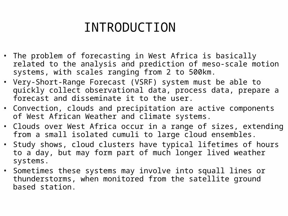
• The problem of forecasting in West Africa is basically related to the analysis and prediction of meso-scale motion systems, with scales ranging from 2 to 500km.
• Very-Short-Range Forecast (VSRF) system must be able to quickly collect observational data, process data, prepare a forecast and disseminate it to the user.
• Convection, clouds and precipitation are active components of West African Weather and climate systems.
• Clouds over West Africa occur in a range of sizes, extending from a small isolated cumuli to large cloud ensembles.
• Study shows, cloud clusters have typical lifetimes of hours to a day, but may form part of much longer lived weather systems.
• Sometimes these systems may involve into squall lines or thunderstorms, when monitored from the satellite ground based station.

STUDY AREA

METHOD OF ANALYSIS
• Forecaster’s Tools Include:MDDPDUSHRPTMESSIR VISION2 Objective analyses and re-analyses of the NWP
forecast MODELS at 850hPa level.3 Systems are displaced 2 to 3 degrees of lats. over
West Africa during wet season.4 Observational data superimposed with the computed
analysis.5 Cloud animation employed to monitor process.

NWP PRODUCTS AND SATELLITE IMAGERY
• Presently, no Limited Area Model (LAM) for the Short-Range Weather Forecasting for West Africa.
• The General Circulation Models (GCMs) used include Meteo France, ECMWF and UK NWP models.

THUNDERSTORM OF 5th MARCH 1999
• 5.0 THUNDERSTORMS OF 5th MARCH 1999
1 The convective activity which started around 1500 UTC on 4th March 1999 (Fig. 2.1), over mainly the mountainous areas of the region as mere cloud patches, developed and moved southwestwards to affect the cities.
2The thunderstorms which were estimated to affect most coastal cities by early morning of 5th March 1999, actually came (Fig. 2.2).

Fig. 2.1 Infra-red satellite Cloud Image. 15:00 UTC, 4 March 1999
(Source: EUMETSAT)

Fig. 2.2 Infra-red satellite Cloud
Image. 01: 30 UTC, 5 March 1999
(Source: EUMETSAT)

STREAMLINE ANALYSIS

STREAMLINE CONT.

SOCIO-ECONOMIC BENEFITS OF VSRF • i) The forecast can bring about safety of lives and
property. Safety reasons have motivated the use of weather forecasts. Weather forecasts or warnings for severe weather can prevent damages on structures and save human life.
• (ii) VSRF is used to increase economic efficiency. In order words, it can be used to minimize weather induced losses. For instance, there is a potential for large economic savings by using VSRF to a large extent
• (iii) VSRF can be used to improve environmental conditions and the quality of life. For instance, leisure time activities can be arranged and planned on the basis of weather forecast

HOW TO IMPROVE THE VSRF
• (a) The VSRF system should be designed on the basis of users needs as well as meteorological, geographical and economic conditions
• (b) A regional model or a Limited Area Model (LAM) can be developed for West Africa so that the basis for imposing Global models on regional parameters is avoided and therefore paves the way to more accurate weather forecasts.
• (c) A VSRF system must be able to quickly collect observational data, process data, prepare a forecast and disseminate it to the appropriate user

CONCLUSION
• The analyses of both satellite data and NWP products have strongly indicated the enhancement of convective activity in the trough region.
• The study however, noted that cloud clusters generally develop as mature organized systems near the centre of cyclonic vorticity and in the regions of an easterly wave where the strongest vertical motions are found.
• Various synoptic analyses have indicated that the convective systems over west Africa occur most frequently near or just to the wave trough at 700 hPa level.


![dishes out 10 [G] AUSTIN RIVERS [F] AL-FAROUQ AMINU](https://img.pdfslide.net/doc/110x75/61f0673e998ad607274438fd/dishes-out-10-g-austin-rivers-f-al-farouq-aminu.jpg)