Embed Size (px)
Citation preview
1
A Closer Look at the FAA’s Drone Data From military crashes to a UFO sighting, AMA analysis reveals a more complex picture of drone activity in the United States – and only a small fraction were legitimately reported as “close calls”
Executive Summary Headlines from the past few weeks are enough to make you rethink your summer vacation. “FAA records detail hundreds of close calls between airplanes and drones,” proclaimed The Washington Post. “Leaked FAA report shows almost 700 close calls between drones and planes,” wrote The Christian Science Monitor. Stories portray drones “clogging U.S. airspace,” “snarling air traffic,” “giving the FAA fits,” and “penetrating some of the most guarded airspace in the country.” As a nationwide community-based organization of more than 180,000 model aviation enthusiasts, the Academy of Model Aeronautics (AMA) is deeply concerned about these reports. Safety is the cornerstone of our organization; our members have been flying model aircraft safely for nearly eight decades. In order to better understand what’s occurring, and what role AMA could play to help advance safe flying, our organization closely analyzed each of the more than 700 records of “drone sightings” recently released by the FAA. Without a doubt, some drones are flying too close to manned aircraft, airports, wildfires, critical infrastructure and in restricted airspace. AMA is concerned about these reports and helped create the ‘Know Before You Fly’ (KBYF) campaign in 2014 to educate newcomers to drone technology about where they should and shouldn’t fly. AMA and its partners continue to work with manufacturers and distributors to include safety brochures in product packaging and/or at the point of sale. To date, six manufacturers and distributors – Castle, DJI, Hobbico, Horizon, Yuneec and UAV Experts – have agreed to include KBYF brochures with their products and even more supporters in the manned and unmanned aviation communities are joining each month. Hobby People, a brick and mortar retailer, is displaying the KBYF materials at the point of sale in all 18 of their stores. DJI, which manufacturers the popular Phantom quadcopter, has also asked its sales dealers to distribute KBYF brochures with drone equipment sales, and has implemented altitude limitations and GPS-based warnings and limitations into its products. Beyond education, AMA has encouraged the FAA to more aggressively enforce existing rules against careless and reckless behavior, as well as violations of restricted airspace. The FAA currently has the authority to assess civil penalties of up to $25,000 against careless and reckless operators. Hefty fines could help deter bad behavior, yet very few fines have been levied to date. While AMA’s members are responsible and know where they should and should not fly, all users of the airspace have a responsibility to ensure safety, and AMA is committed to doing its part.

2
At the same time, AMA’s analysis of the FAA data shows that the number of “close calls” and “near misses” is substantially lower than the headlines would suggest. So what’s in the data? A closer look reveals a hodgepodge of reports. Some of the key takeaways:
• Not every sighting or report was a ”close call.” Many were just that – sightings. Only a small fraction was legitimately reported as “near misses” or “near mid-air collisions.”
• Some of the most serious incidents in the FAA data – including two actual crashes – involve government-authorized military drones, not civilian drones.
• It’s not just uninformed consumers causing problems; the records include several reports of authorized or unauthorized public entities and commercial operators flying. Given the widespread interest in commercial applications, unidentified operators cannot be presumed to be “hobbyists.”
• Some sightings appear to involve people flying responsibly and within the FAA’s current recreational guidelines.
• Many things in the air – from balloons and birds to model rockets and mini blimps – are mistaken for, or reported as, drone sightings even when they are not. One pilot in Minnesota even reported seeing something that “resembled a dog.”
• A number of sightings have occurred over or around stadium events, wildfires,
power plants and other critical infrastructure. These raise different concerns from pilot sightings.
• Despite the FAA’s stated desire to find and punish rogue operators, in almost 20% of reports – 142 reports, to be exact – local law enforcement either wasn’t notified or it was unknown whether local law enforcement was notified.
The following analysis delves into each of these findings in greater detail. Meanwhile, the conclusion contains recommendations for the FAA going forward, both in terms of how this data should be released in the future as well as what more can be done to address instances of irresponsible operations.
3
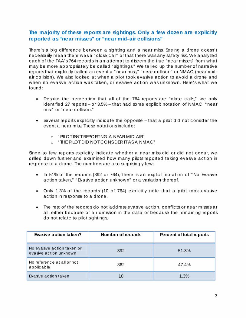
The majority of these reports are sightings. Only a few dozen are explicitly reported as “near misses” or “near mid-air collisions” There’s a big difference between a sighting and a near miss. Seeing a drone doesn’t necessarily mean there was a “close call” or that there was any safety risk. We analyzed each of the FAA’s 764 records in an attempt to discern the true “near misses” from what may be more appropriately be called “sightings.” We tallied up the number of narrative reports that explicitly called an event a “near miss,” “near collision” or NMAC (near mid-air collision). We also looked at when a pilot took evasive action to avoid a drone and when no evasive action was taken, or evasive action was unknown. Here’s what we found:
• Despite the perception that all of the 764 reports are “close calls,” we only identified 27 reports – or 3.5% – that had some explicit notation of NMAC, “near miss” or “near collision.”
• Several reports explicitly indicate the opposite – that a pilot did not consider the
event a near miss. These notations include:
o “PILOT ISN'T REPORTING A NEAR MID-AIR” o “THE PILOT DID NOT CONSIDER IT AS A NMAC”
Since so few reports explicitly indicate whether a near miss did or did not occur, we drilled down further and examined how many pilots reported taking evasive action in response to a drone. The numbers are also surprisingly few:
• In 51% of the records (392 or 764), there is an explicit notation of “No Evasive action taken,” “Evasive action unknown” or a variation thereof.
• Only 1.3% of the records (10 of 764) explicitly note that a pilot took evasive
action in response to a drone.
• The rest of the records do not address evasive action, conflicts or near misses at all, either because of an omission in the data or because the remaining reports do not relate to pilot sightings.
Evasive action taken? Number of records Percent of total reports
No evasive action taken or evasive action unknown 392 51.3%
No reference at all or not applicable 362 47.4%
Evasive action taken 10 1.3%

4
AMA’s Recommendation(s): The FAA needs to better analyze and categorize pilot reports to indicate which present serious safety risks (near mid-air collisions) and which could be more appropriately classified as sightings. There are several issues with the FAA’s handling of this most recent announcement of drone sightings. First, the FAA fueled inaccurate and sensational headlines claiming that all drone reports involve “close calls,” which even a causal review of the FAA’s data shows is inaccurate. This happened first and foremost because the agency’s own press release from August 12, 2015, bears the headline, “Pilot Reports of Close Calls With Drones Soar in 2015” and
the FAA cited more than 650 reports.1 When the actual reporting data was released on August 21, the FAA’s characterization changed dramatically to describe these same reports as merely “possible encounters.” During that intervening two-week period, public opinion was influenced by media coverage that relied upon, and cited, the FAA’s description of these 650 possible encounters as “close calls.” These media reports have, in turn, been cited by lawmakers in Washington and in various states as a reason to call for new legal restrictions. More recently, the FAA admitted in an August 30 news story that there is no regulatory definition for what constitutes a “close call.” The agency said the phrase was “simply part of a news headline,”2 Implying that the agency may have intentionally used sensational language to spur media interest in its data. The general public, the media, our nation’s lawmakers, and all stakeholders in drone technology deserve better from the government agency responsible for the safety of the nation’s skies and for reporting objectively and accurately on public safety issues.
1 http://www.faa.gov/news/updates/?newsId=83445 2 http://www.journalnow.com/news/local/cloudy-faa-data-skews-drone-threat/article_80e10858-3fbb-51ba-827c-e5fb55a26534.html
FAA’s characterization of its data has led to sensationalized and
inaccurate reporting, including in The Washington Post.

5
Most importantly, the FAA’s lack of analysis makes it more difficult for the broader community, whether recreational or commercial, to easily identify the most serious safety risks and work toward advancing solutions. There is a flattening of perception that every report is just as important as the next, which clearly isn’t the case. Some reports in the data – where near misses occurred or when pilots took evasive action – deserve more attention than others. Meanwhile, the release of preliminary, raw data without any analysis, context or investigative findings only tells part of the story. Presumably there are investigative findings and other information on at least some of these sightings that would shed light greater on their accuracy or legitimacy. The FAA should be more transparent with this information. Military drones, not civilian drones, are involved in some of the most serious incidents, including all actual crashes While civilian drones have been the focus of news reports, more than a dozen events in the FAA data involve military drones, or are very likely FAA-approved military drone operations. What’s more, the incidents involving military drones are among the most serious in the data, including two actual crashes.
• On July 24, 2015, Lockheed Martin lost control of a small military drone in Owego, NY, prompting the operator to alert a nearby control tower to “watch out.”
• On May 26, 2015, a Swedish Air Force C-130 climbed to avoid a military MQ-9
Reaper drone near Victorville, CA.
• On March 25, 2015, an MQ-1C military drone crashed near Wilsona Gardens, CA. The MQ-1C, manufactured by General Atomics, is reportedly an upgrade to the popular Predator drone.3
• In what may be the same event as above, on March 25, 2015, a citizen in Lancaster, CA reported that a “25 foot drone crashed” in a residential neighborhood. A photo was posted to the website of a local radio station.4
• On March 3, 2015, controllers at MacDill Air Force Base in Tampa, FL reported that a drone weighing “less than 300 pounds” crashed by the perimeter fence of the base.
While the incidents detailed above are among the most serious, there are several other reports involving military drones, or possibly military drones.
3 http://www.ga-asi.com/gray-eagle 4 http://www.kfiam640.com/onair/john-and-ken-37487/check-out-this-photo-of-a-13446744/

6
• A Cessna pilot in Van Nuys, CA reported a “huge, silver, military style UAS” which passed a few hundred feet overhead.
• A U.S. Army aircraft operating near Washington, D.C. reported seeing a drone that is “dark gray and smaller than a Predator.”
• A VFR pilot in Anchorage, AK entered “hot” restricted airspace where a military
drone was operating. The number of reports involving military drones, or possible military drones, calls into question how many other reports in the FAA data may have been sightings of military aircraft. This is especially true of sightings at higher altitudes, including Class A airspace, which is the airspace between 18,000 feet and 60,000 feet above sea level. Reaching Class A airspace is generally beyond the capabilities of model aircraft and consumer-grade drones. Indeed, the most popular consumer drone sold today, the DJI Phantom, has a built-in maximum altitude function. The FAA data includes reports of drone sightings at the following unusually high altitudes:
• 24,000 feet – July 24, 2015, near Colorado Springs, CO
• 51,000 feet – July 24, 2015 near Washington, D.C.
• 20,000 feet – March 5, 2015 near Los Angeles, CA
• 25,000 feet – February 9, 2015 near Teterboro, NJ
• 25,500 feet – February 9, 2015 near West Palm Beach, FL
• 19,000 feet – November 24, 2014 near Beaumont, TX To put these reports into context, many small manned aircraft cannot even reach these heights. For example, the service ceiling – the maximum achievable altitude – of a single-engine Cessna Skyhawk (C172) is 14,000 feet.5 Likewise, the maximum operating altitude of a manned Robinson R22 helicopter is 14,000 feet.6
AMA’s Recommendation: The FAA should separate out reports that involve military or government agency-operated drones, or that likely involve such drones, from future drone sighting data. This could either mean excluding these military reports entirely, or explicitly indicating when the report relates to military use, and not civilian use, of a drone. These incidents should not be included in reported numbers of civilian drone sightings. 5 http://cessna.txtav.com/single-engine/skyhawk 6 http://www.robinsonheli.com/rhc_r22_beta_ii.html

7
There are public entities and commercial operators in the FAA’s reports too The FAA currently prohibits commercial drone use unless the operator has received a Section 333 exemption to fly. Likewise, public entities wanting to fly drones – including publicly funded universities, law enforcement agencies, fire departments and other government agencies – can do so by applying for a Certificate of Waiver or Authorization (COA) from the FAA. Despite the perception that all irresponsible operators are uninformed consumers or recreational users, the FAA data reveal several instances of public entities and commercial operations – some or all of which may have been unauthorized.
• In perhaps the most surprising example, on August 18, 2015, the Los Angeles Police Department notified the Inglewood Police Department that a drone the latter agency was flying over a crime scene “needed to come down.” The drone was flying two miles from the approach end of a runway at LAX.
• On August 5, 2015, the Coast Guard in Mobile, AL reported a drone being used to film a commercial for a car dealership, in close proximity to the Mobile airport. The report notes that the company involved “does not appear to have a section 333 exemption.”
• On August 2, 2015, authorities in Pomona, CA observed a drone flying over a
concert, ¼ mile from a nearby airport. The report states the drone was operated by the event host, Live Nation.
• On July 7, 2015, a pilot in Redding, CA reported a drone ¼ mile from the runway of a local airport. Local police verified that the drone was being operated by a construction company, which was advised to cease operations.
• On April 28, 2015, a local photography and marketing business in Winchester, VA was reportedly hired to capture aerial photos of the Shenandoah Apple Blossom Festival. The same company may have also used a drone to produce a public service announcement for the Winchester Public Schools. The company does not appear to have FAA approval to fly. Meanwhile, the superintendent of the Winchester Public Schools said the business owner, “does this all the time.”
Whether innocent or intentional, there are some public entities and commercial operators in the FAA’s data. Meanwhile, as with the military reports, the presence of several clearly identifiable public entities and commercial operators in the reports raises questions about how many other drone sightings may be authorized or unauthorized public entities and commercial operators. All of the sightings like these have been inaccurately and unfairly characterized by the FAA as “hobbyist” operations, when clearly not all are. AMA Recommendation(s): As with military reports, the FAA should clearly separate out and explicitly indicate reports that are public entities and commercial operators, or very

8
likely public entities and commercial operators. In the absence of any operator identification, and given the heightened interest in commercial applications, it is inappropriate to assume, or to report, that a drone was operated by a “hobbyist.” Meanwhile, the FAA needs to finalize its small UAS (drone) rules without any further delays. Congress directed the FAA to put these rules in place by September 30, 2015, a deadline the agency is likely to miss. The faster these rules are finalized, the faster public entities and commercial operators will have a regulatory framework with clear requirements in which to operate. Rules won’t just help public entities and commercial operators; they will enhance safety across the board by requiring everyone to follow either the new rules for commercial operators or the safety programming of a community-based organization (CBO), like the AMA. Some drone flyers appear to be following proper recreational guidelines, yet they are reported anyway One of the more surprising findings in the FAA data is the discovery that, in at least half a dozen instances, some drone flyers may be following FAA-endorsed recreational guidelines. Yet, these users are reported and included in the FAA data set because of a citizen or pilot who is unfamiliar with the proper guidelines. The FAA has indicated that recreational flyers should stay below 400 feet, stay well clear of manned aircraft, fly their drones or model aircraft within visual line of sight at all times and not fly within five miles of an airport without prior notification to the airport operator or air traffic control tower (when an air traffic facility is located at the airport). Below are examples of reports that appear to meet these guidelines:
• On July 24, 2015, a “low flying” drone was reported five miles south of the Leigh Valley International Airport in Allentown, PA. No specific altitude was reported.
• On June 10, 2015, a helicopter flying “below 500 feet” reported seeing a drone
five miles away from Fort Lauderdale-Hollywood International Airport.
• On April 28, 2015, a 9-1-1 caller reported a drone 13 miles from Chicago Midway International Airport. The caller stated the drone was “not high.”
• On March 28, 2015, a resident of Sioux Falls, SD reported a drone flying “around the area...at 400 feet.”
• On February 14, 2015, a drone was reported “below 400 feet” in the vicinity of downtown Anchorage, AK.
• That same day, a helicopter reported a drone 6.5 miles away from Miami International Airport at an altitude of “400-500 feet.”
9
• Also in Miami, on December 14, 2014, a helicopter pilot reported a drone at 150 feet, 5 miles from Miami International Airport.
These are just some of the reports that may actually be cases of safe and responsible operators who are flying within the FAA’s current guidelines. There may be many other operators following the guidelines in the data set, but it’s difficult to discern because of the two different ways altitudes are reported. When pilots report drone sightings, they typically report the MSL (mean sea level altitude) of their aircraft along with the sighting. That’s because altimeters in manned aircraft measure altitude above sea level. Drone enthusiasts on the ground are advised to stay under 400 feet AGL (above ground level). At sea level, 400 feet MSL equals 400 feet AGL. As a practical matter, the ground elevation of most places in the country is higher than sea level, especially in western states. This means that, to get a true picture of how high a drone may be flying above its location, one needs to subtract the ground elevation from an altitude report given in mean sea level. Consider the following hypothetical example. A drone enthusiast flying six miles away from Denver International Airport (DEN) believes he is following all of the appropriate recreational guidelines, including staying below 400 feet. Meanwhile, a pilot landing at DEN reports a drone off in the distance at 5,700 feet. Is this operator doing something wrong? No. The pilot is reporting his altitude above sea level, 5,700 feet. The field elevation of the Denver airport is 5,327 feet. That means that the drone is actually flying at 373 feet above ground – under 400 feet. In this instance, there is no “close call” and no danger to the manned aircraft, it is merely a reported sighting of a drone operation that is in compliance with FAA guidelines, which include the instruction that drones should yield right of way to manned aircraft. The direction to yield right of way necessarily means that drones and manned aircraft will be visible to each other’s pilots, and that sightings will occur and will be reported. AMA Recommendation(s): First and foremost, the FAA should exclude from its records any reports where the operator is following, or very likely following, recreational guidelines. There are at least a few of these. By including these reports – and only including preliminary data – the agency is essentially considering all drone operators guilty until proven innocent. The presumption is, if someone sees a drone and makes a report, the drone operator is automatically doing something wrong, which isn’t always the case. These reports also underscore the problems with preliminary data. Some of the reports noted above, as well as others in the data set, may later have been investigated and found to be safe and/or appropriate flights. But the public doesn’t know if that’s the
10
case because no investigative findings are being released. As stated previously, the FAA needs to be more transparent and release more information, not less. Finally, in keeping with greater transparency, the FAA needs to clear up the ambiguities in altitude reporting going forward. Specifically, AMA would like to see any altitudes for drone sightings reported in AGL altitude, in addition to the MSL altitudes reported by some pilots. This conversion could be done, or at least approximated, by using the field elevation of the nearest airport. It is also important for pilots to be prompted to include in their reports the estimated altitude of the drone they have observed, not just their own altitude. Drones are the new UFOs…except for one report of an actual UFO In more than a dozen FAA records, pilots either reported seeing “something” other than a drone, or a pilot was unsure whether an object was a drone at all. Such an object is, quite literally, an unidentified flying object (“UFO”). However, it seems the term “drone” has become the new UFO, applying to everything from balloons and birds to model rockets and mini blimps. A few examples:
• On August 12, 2015, a pilot in Salt Lake City, UT reported seeing “an ultra light or drone type aircraft.”
• On July 19, 2015, ground personnel at JFK in New York reported a cluster of silver balloons blowing over the airport fence. Controllers in the tower also noted seeing “a silver object.”
• Also at JFK, on July 10, 2015, a JetBlue pilot reported seeing “a fast moving gray object.”
• On July 5, 2015, an American Airlines pilot near LaGuardia Airport in New York reported seeing a “model rocket” at 2,800 feet.
• On May 31, 2015, a Quantas pilot reported seeing a “mini blimp” at LAX in Los Angeles.
• In one of the more ambiguous reports, on April 5, 2015, an Alaska Airlines pilot near Des Moines, WA “reported seeing something below” his aircraft.
• In what could have been a sighting of a manned aircraft, on February 10, 2015, a Southwest Airlines pilot reported seeing an “unidentified helicopter” while on final approach to LAX in Los Angeles.
• On November 30, 2014, a plane landing at Andrews Air Force Base outside of Washington, D.C. reported seeing a drone that looked like a “large vulture.”

11
There are several more reports that indicate that pilots, at times, aren’t sure what they’re seeing. “Pilot was not positive that the object he saw was a drone” reads one entry from Sarasota, FL. A pilot in Georgia reported seeing “a red UAS (or balloon).” Similarly, a pilot near San Francisco, CA reported “a UAS or balloon at 10,000 feet.” While any object in the sky seems to be reported as a drone, occasionally a UFO is still a UFO. On July 24, 2015, two aircraft near Washington, D.C. spotted what they describe as a UFO at 51,000 feet – higher than commercial airliners typically fly. Even airline pilots who fly very close to these “UFOs” can misperceive what they are. In one report, an airline pilot reported that his aircraft had actually collided with a drone and created sparks. Upon landing, an investigation revealed that his aircraft had actually collided with a bird. With approximately 10 billion birds in the United States, and with many birds presenting an anatomical shape in flight that is similar to the “X” shape of a quadcopter drone, it is quite conceivable that at least some of these reports are actually bird sightings. It is also apparent that the FAA’s reporting system reflected in the summary spreadsheet released to the public on August 21 is not always accurate or complete. For example, the spreadsheet indicates that on January 31, 2015, the pilot of United flight 1087 on approach to Boston’s Logan Airport “REPORTED SEEING A UAS 100 FEET ABOVE ACFT ALTITUDE OF 7,000 FEET FOOTBALL SHAPED RED-BLUE IN COLOR.” However, the ATC audio recording indicates that the pilot actually reported: “I don’t know if it was a balloon or a drone.”7 The FAA’s spreadsheet omits any mention of the possibility that this object was a balloon, even though the shape, altitude and pilot’s audio recording all point to that as the more likely explanation. This misreporting by the FAA’s own system suggests a bias towards reporting flying objects as drones even when the existing evidence indicates otherwise. AMA Recommendation(s): The FAA shouldn’t include reports of flying objects that are clearly not drones – balloons, model rockets, birds, etc. - in its data. The FAA should also separate out and clearly identify reports that are ambiguous – something below the aircraft, dark gray object, etc. – or which express doubt as to whether a flying object is, in fact, a drone. The report should include all facts as reported by the pilot to ATC, FAA or the airline, including any uncertainty about the object that was sighted.
7 http://www.wcvb.com/news/drone-sighted-by-pilot-landing-at-logan/31035050
A UFO Sighting? “A/C REPORTED A UFO AT 150NM NORTH OF SWL APPROXIMATE FL510 MOVING FROM WEST TO EAST JUST ABOVE HORIZON WITH STEADY LIGHT ILLUMINATION. FAST MOVING DUE EAST GONE WITHIN 5 MINUTES. AVA020 CONCURRED WITH THIS REPORT. REPORT TO HQ/DEN.”

12
The data isn’t all about pilots and airliners. People are flying over stadium events, wildfires, power plants and other places that may raise different concerns While the FAA’s press release and subsequent news coverage of the drone data focus on pilot reports and airliners, we have identified at least 26 records of drones flying near stadium events, wildfires, critical infrastructure and in restricted airspace. While these are potentially objectionable if unauthorized, they are certainly not “close calls” when no other aircraft is reported in the area.
For stadium events, wildfires and VIP movements, the FAA typically issues temporary flight restrictions (TFRs) that limit access to the airspace for both manned and unmanned aircraft. For example, the FAA restricts flights over stadiums during Major League Baseball games, National Football League games, NCAA games and motor speedway events. The so-called “stadium TFR” prohibits aircraft operations at or below 3,000 feet AGL within a three nautical mile radius of any stadium with a seating capacity of 30,000 or more. The TFRs go into effect one hour before the scheduled event time and last until one hour after the event concludes. Specifically, our analysis found:
• At least six reports of drone activity in and around Washington, DC’s restricted airspace, including drones incidents at the White House that have been the subject of extensive media coverage.
• In another instance of a security breach, the Coast Guard reported a drone in the vicinity of the President playing golf in West Palm Beach, FL.
• At least 13 sightings involve stadiums or large event venues. However, it is often not noted whether a TFR was in place at the time of the report.
• There are at least four reports of drones flying near power plants in Maine, Wisconsin and
Drones over stadiums According the FAA data, drones have been sighted over the following stadiums and event venues, in some cases more than once: • University of Alabama
Stadium, Tuscaloosa, AL • High School Football
Stadium, Glendale, AZ • Levi’s Stadium, San Jose,
CA • Stanford University
Stadium, Stanford, CA • Nationals Park,
Washington, DC • Marlins Park, Miami, FL • Fenway Park, Boston, MA • Bank of America Stadium,
Charlotte, NC • Citi Field, New York, NY • PNC Park, Pittsburgh, PA • Seahawks Training Camp,
Renton, WA
SOURCE: FAA database on Pilot UAS reports
13
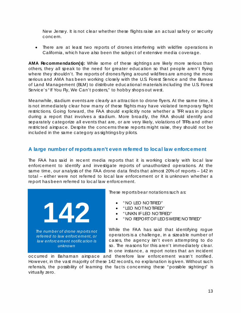
New Jersey. It is not clear whether these flights raise an actual safety or security concern.
• There are at least two reports of drones interfering with wildfire operations in California, which have also been the subject of extensive media coverage.
AMA Recommendation(s): While some of these sightings are likely more serious than others, they all speak to the need for greater education so that people aren’t flying where they shouldn’t. The reports of drones flying around wildfires are among the more serious and AMA has been working closely with the U.S. Forest Service and the Bureau of Land Management (BLM) to distribute educational materials including the U.S. Forest Service’s “If You Fly, We Can’t posters,” to hobby shops out west. Meanwhile, stadium events are clearly an attraction to drone flyers. At the same time, it is not immediately clear how many of these flights may have violated temporary flight restrictions. Going forward, the FAA should explicitly note whether a TFR was in place during a report that involves a stadium. More broadly, the FAA should identify and separately categorize all events that are, or are very likely, violations of TFRs and other restricted airspace. Despite the concerns these reports might raise, they should not be included in the same category as sightings by pilots. A large number of reports aren’t even referred to local law enforcement The FAA has said in recent media reports that it is working closely with local law enforcement to identify and investigate reports of unauthorized operations. At the same time, our analysis of the FAA drone data finds that almost 20% of reports – 142 in total – either were not referred to local law enforcement or it is unknown whether a report has been referred to local law enforcement.
These reports bear notations such as:
• “NO LEO NOTIFIED” • “LEO NOT NOTIFIED” • “UNKN IF LEO NOTIFIED” • “NO REPORT OF LEOS WERE NOTIFIED”
While the FAA has said that identifying rogue operators is a challenge, in a sizeable number of cases, the agency isn’t even attempting to do so. The reasons for this aren’t immediately clear. In one instance, a report notes that an incident
occurred in Bahaman airspace and therefore law enforcement wasn’t notified. However, in the vast majority of these 142 records, no explanation is given. Without such referrals, the possibility of learning the facts concerning these “possible sightings” is virtually zero.
142 The number of drone reports not referred to law enforcement, or law enforcement notification is
unknown
14
AMA Recommendation(s): The AMA has been calling for more aggressive enforcement of careless and reckless operators and therefore urges the FAA to, as a starting point, report all instances of potentially irresponsible behavior to local law enforcement for further investigation. Our analysis has shown that not all of these reports are equally serious, and some reports may actually be people flying responsibly. That said, it is clear that greater communication and coordination between the FAA and local law enforcement is needed to identify and hold accountable operators who pose a danger to the national airspace system. Conclusion A close examination of the FAA’s drone data reveals a much more complex picture of drone activity in the U.S. There are pilot reports of near misses that represent actual safety concerns, and more needs to be done to address these. But contrary to the FAA’s assertion in its press release of August 12, and the widespread media reporting that followed, the narrative descriptions and notations in the 764 reports suggest that the number of actual “close calls” appears to be in the dozens, not the hundreds.
Moreover, the assumption that all drone flyers are “hobbyists” or recreational users is clearly inaccurate. As noted in this analysis, there are several instances of military sightings and mishaps, including two actual crashes. There are also public entities and commercial operators flying with or without authorization. When the operator is not identified, it is not possible to determine the purpose of the operation. Further, some reports may actually be drones operating responsibly pursuant to FAA guidelines, and some reported sightings of drones may not even be drones at all.
There is some useful information in the FAA’s dataset – data that could help guide policy conversations about drones and help all stakeholders identify solutions to mitigate true safety risks. But the data is only useful if the FAA takes the time to analyze and accurately characterize it; the same holds true for the media and others.
While AMA works closely with the FAA, and we continue to consider the agency a partner in promoting model aircraft and consumer drone safety, the FAA mishandled the release of its drone data. The agency used misleading language in its press release, released only preliminary reports and did not critically analyze those reports. The agency should not have asserted in the media that there are hundreds of reports of “close calls” with drones when that is not supported by the data, and the agency admits that it has no regulatory definition of what constitutes a “close call.”
Moving forward, AMA has two sets of recommendations – one set of recommendations relating to the FAA’s handling of its drone data, and another set of recommendations to ensure the continued safety of the U.S. airspace.
Data recommendations:

15
1. Don’t just release raw reports or summary numbers; analyze all future drone data. The AMA believes the FAA needs to conduct an analysis of all future data releases in order to more accurately portray what is happening. AMA recommends that these reports need to be better categorized going forward to highlight the most serious safety risks so that all stakeholders can work together to address them. Some of the categories or filters AMA recommends include:
• Near misses / near mid air collisions • Sightings / not reported as a near miss • Military reports / reports involving military or government agency drones • Commercial reports / reports involving commercial use • Potential violations of TFRs or other restricted airspace • Note which reports are airborne pilot reports vs. ground reports
Additionally, reports relating to balloons, UFOs, model rockets and other flying objects should not be included in the drone data. In addition to better categorizing the reports, the AMA urges the FAA to provide greater context for these reports, which includes:
• Computing the approximate AGL (above ground level altitude) of any
drone reports that are stated in MSL (mean sea level) altitudes. • Cross-referencing stadium reports with past TFRs (temporary flight
restrictions) and explicitly noting whether a TFR was in effect during a stadium-related sighting.
2. Release not just preliminary reports or numbers, but also investigative findings and
any other information. The problem with preliminary reports is just that – they are preliminary. Once investigated, the reports may turn out to be accurate. However, there’s reason to believe that some may be inaccurate. While the FAA only released the preliminary data to the public, The Washington Post reportedly obtained some investigative findings. In one instance, a pilot reported hitting a drone, only later to determine that it was a bird. The Washington Post on August 20, 2015 reports:
On May 9, the pilot of United Airlines Flight 863 — traveling from San Francisco to Sydney — reported that the Boeing 777 hit a drone at an altitude of 3,000 to 4,000 feet along the California coast. “Sparks were observed after contact,” according to the FAA report, which said the 777 kept flying because it did not appear to be damaged. A United spokesman said it was later determined that the plane had hit a bird, not a drone.
This incorrect report, from a pilot who was close enough to actually see the object his aircraft collided with, is a good example of why initial reports cannot be relied upon to draw conclusions that might influence policy decisions. The general public, the media, lawmakers, and drone stakeholders deserve greater transparency.

16
Policy recommendations:
Safety is a top priority for the AMA. Our members have been flying model aircraft safely for nearly eight decades and want to see everyone embrace new drone technology safely and responsibly. While our analysis finds several serious issues with the FAA’s data, we are aligned with the FAA when it comes to promoting the safety of the nation’s airspace. In light of some of the reports that may constitute careless and reckless behavior, AMA recommends the following:
1. Refer all reports to local law enforcement. As noted in our analysis, more than 140
reports either weren’t referred to local law enforcement or it is not known whether local law enforcement was notified. While not every report is a serious safety risk, or even someone behaving irresponsibly, the only way to identify the truly careless and reckless operators, and to learn the facts about what happened, is better communication and coordination with local law enforcement.
2. More aggressively enforce existing rules. There are existing federal rules against
careless and reckless operations, for which the FAA can fine operators up to $25,000. In many jurisdictions, there are also criminal laws under which careless and reckless operators could be prosecuted. Despite the FAA having the authority to levy hefty penalties, very few fines have been assessed to date. AMA supports the FAA taking a more aggressive approach to assessing civil penalties against operators who endanger the safety of the national airspace system.
3. Finalize the small UAS rules. One of the most immediate things the FAA can do to
increase safety is to finalize its small UAS rules. The draft rules will enhance safety by requiring everyone who wants to fly to either follow the safety programming of a community-based organization (CBO), like AMA, or follow new FAA rules for commercial operators. Once this happens, everyone would need to have some level of oversight and education in order to legally fly. These rules have been delayed several times and, in all likelihood, the FAA will miss its congressionally-mandated deadline of September 30, 2015 to issue final rules.
4. Continue to educate new users. Many of these reports underscore the need for
more education of newcomers to the technology who aren’t traditional model aviation enthusiasts and who aren’t trained aviators. AMA is committed to continue advancing safety education under the “Know Before You Fly” campaign along with its campaign partners the Association for Unmanned Vehicle Systems International and the FAA. The FAA itself encourages model aircraft operators: “Do take lessons and learn to fly safely.”8 One of the keys to this commendable suggestion is to recognize that compensation of an instructor’s time that is spent helping someone learn how to operate a model aircraft or recreational drone must not be viewed as commercial operation of a UAS requiring a Section 333 exemption and pilot certificate.
8 https://www.faa.gov/uas/publications/model_aircraft_operators/