Embed Size (px)
Citation preview
EARTH SURFACE PROCESSES AND LANDFORMS, VOL 22, 1089–1107 (1997)
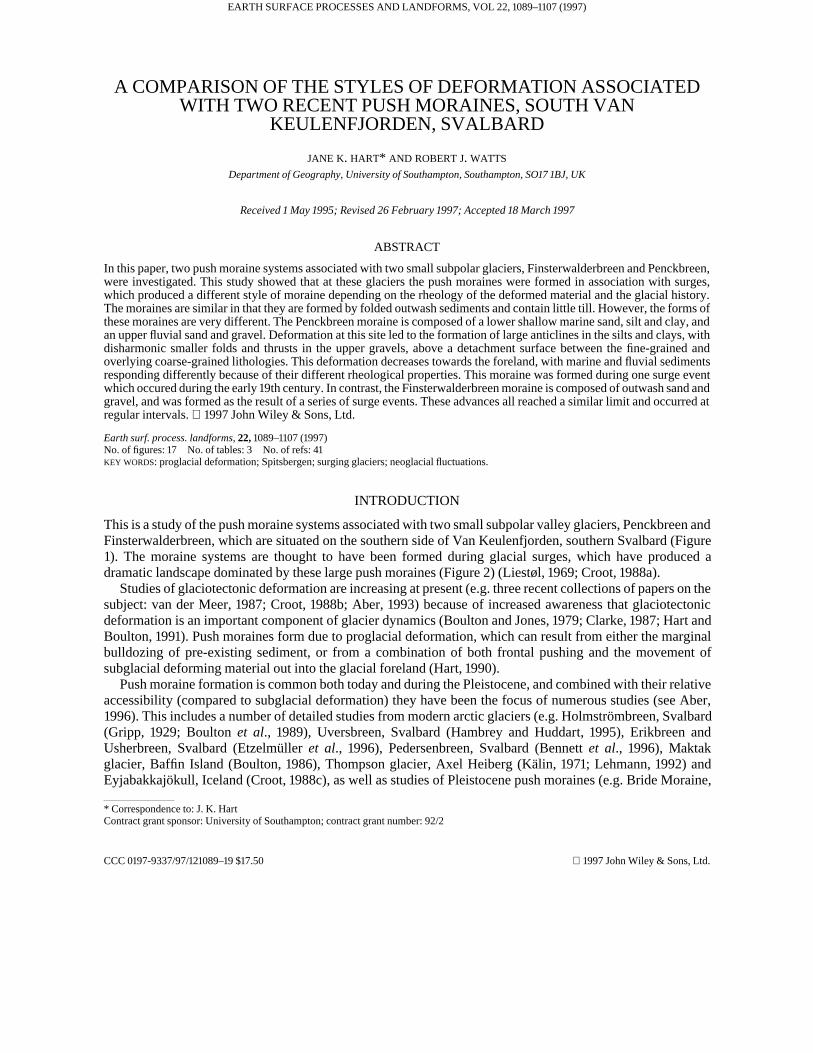
A COMPARISON OF THE STYLES OF DEFORMATION ASSOCIATEDWITH TWO RECENT PUSH MORAINES, SOUTH VAN
KEULENFJORDEN, SVALBARD
JANE K. HART* AND ROBERT J. WATTS
Department of Geography, University of Southampton, Southampton, SO17 1BJ, UK
Received 1 May 1995; Revised 26 February 1997; Accepted 18 March 1997
ABSTRACT
In this paper, two push moraine systems associated with two small subpolar glaciers, Finsterwalderbreen and Penckbreen,were investigated. This study showed that at these glaciers the push moraines were formed in association with surges,which produced a different style of moraine depending on the rheology of the deformed material and the glacial history.The moraines are similar in that they are formed by folded outwash sediments and contain little till. However, the forms ofthese moraines are very different. The Penckbreen moraine is composed of a lower shallow marine sand, silt and clay, andan upper fluvial sand and gravel. Deformation at this site led to the formation of large anticlines in the silts and clays, withdisharmonic smaller folds and thrusts in the upper gravels, above a detachment surface between the fine-grained andoverlying coarse-grained lithologies. This deformation decreases towards the foreland, with marine and fluvial sedimentsresponding differently because of their different rheological properties. This moraine was formed during one surge eventwhich occured during the early 19th century. In contrast, the Finsterwalderbreen moraine is composed of outwash sand andgravel, and was formed as the result of a series of surge events. These advances all reached a similar limit and occurred atregular intervals. 1997 John Wiley & Sons, Ltd.
Earth surf. process. landforms, 22, 1089–1107 (1997)No. of figures: 17 No. of tables: 3 No. of refs: 41KEY WORDS: proglacial deformation; Spitsbergen; surging glaciers; neoglacial fluctuations.
INTRODUCTION
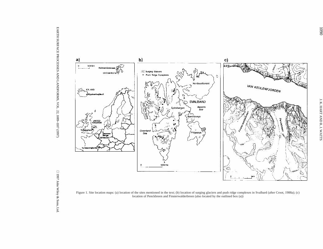
This is a study of the push moraine systems associated with two small subpolar valley glaciers, Penckbreen andFinsterwalderbreen, which are situated on the southern side of Van Keulenfjorden, southern Svalbard (Figure1). The moraine systems are thought to have been formed during glacial surges, which have produced adramatic landscape dominated by these large push moraines (Figure 2) (Liestøl, 1969; Croot, 1988a).
Studies of glaciotectonic deformation are increasing at present (e.g. three recent collections of papers on thesubject: van der Meer, 1987; Croot, 1988b; Aber, 1993) because of increased awareness that glaciotectonicdeformation is an important component of glacier dynamics (Boulton and Jones, 1979; Clarke, 1987; Hart andBoulton, 1991). Push moraines form due to proglacial deformation, which can result from either the marginalbulldozing of pre-existing sediment, or from a combination of both frontal pushing and the movement ofsubglacial deforming material out into the glacial foreland (Hart, 1990).
Push moraine formation is common both today and during the Pleistocene, and combined with their relativeaccessibility (compared to subglacial deformation) they have been the focus of numerous studies (see Aber,1996). This includes a number of detailed studies from modern arctic glaciers (e.g. Holmströmbreen, Svalbard(Gripp, 1929; Boulton et al., 1989), Uversbreen, Svalbard (Hambrey and Huddart, 1995), Erikbreen andUsherbreen, Svalbard (Etzelmüller et al., 1996), Pedersenbreen, Svalbard (Bennett et al., 1996), Maktakglacier, Baffin Island (Boulton, 1986), Thompson glacier, Axel Heiberg (Kälin, 1971; Lehmann, 1992) andEyjabakkajökull, Iceland (Croot, 1988c), as well as studies of Pleistocene push moraines (e.g. Bride Moraine,
* Correspondence to: J. K. HartContract grant sponsor: University of Southampton; contract grant number: 92/2
CCC 0197-9337/97/121089–19 $17.50 1997 John Wiley & Sons, Ltd.
1090J. K
. HA
RT
AN
D R
. J. WA
TT
S
Figure 1. Site location maps: (a) location of the sites mentioned in the text; (b) location of surging glaciers and push ridge complexes in Svalbard (after Croot, 1988a); (c)location of Penckbreen and Finsterwalderbreen (also located by the outlined box (a))
EA
RT
H SU
RFA
CE
PRO
CE
SSES A
ND
LA
ND
FOR
MS, V
OL
. 22, 1089–1107 (1997)
1997 John Wiley &
Sons, Ltd.

1091DEFORMATION OF PUSH MORAINES
(a) (b)
Figure 2. Photographs of: (a) Penckbreen push moraine; (b) Finsterwalderbreen push moraine
Isle of Man (Thomas, 1984), Cromer Ridge, UK (Hart, 1990), Dammer Berge, Germany (van der Wateren,1987), Melabakkar-Ásbakkar, Iceland (Ingólfsson, 1988; Hart, 1994) and Lake Pukaki, New Zealand (Hart,1996a). In this paper, we show the results from the detailed investigations of the two sites and go on to comparethese with other push moraines formed by surging and non-surging glaciers.
USING LICHENOMETRY TO DATE PUSH MORAINE FORMATION
In arctic areas, lichens are often the only way to date landscape-forming events, because of the lack of historicalrecords. Lichens can be used to find both relative and absolute dates. However, lichenometry can beproblematic since lichen growth is not simply related to age (for discussion of the problems and techniques, seeLocke et al (1979)). The dating of push moraines is even more difficult because lichens may have been alreadygrowing on the land surface prior to the deformation event. At the two push moraine sites discussed below, itwill be shown that the push moraines formed from the proglacial compression of pre-existing outwash surfaces.
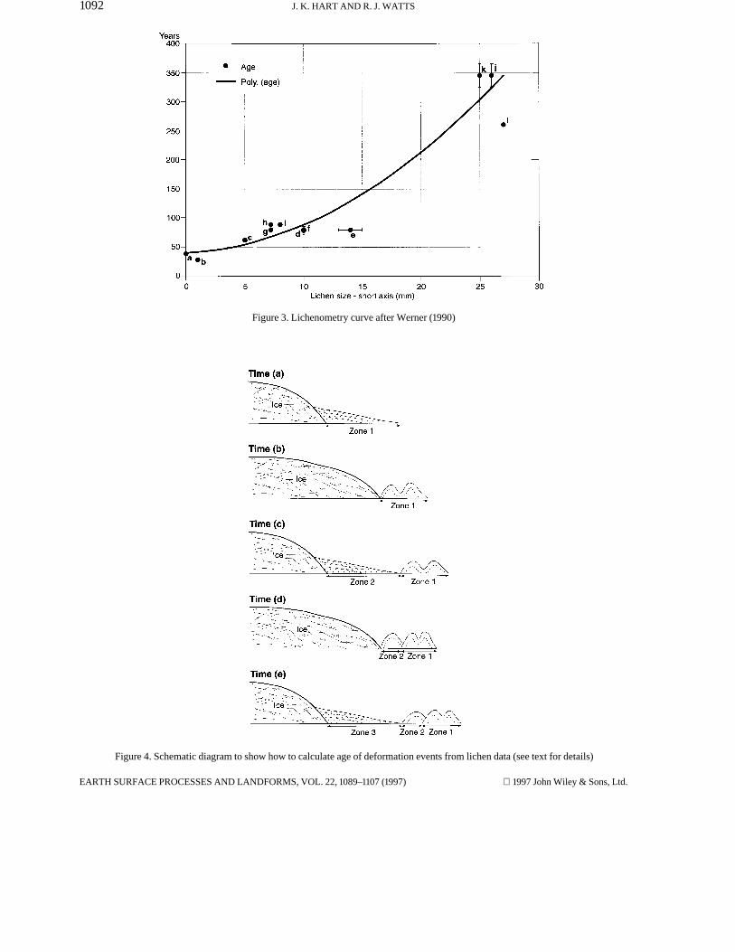
Werner (1990) produced a growth curve for Rhizocarpon based on known historical dated surfaces inSvalbard, based on measuring the short-axis average of the five largest thalli to date the lichens. His results areshown in Figure 3, and a polynomial trendline fitted through these data gives a lichen as follows:
y=0·38x2+0·81x+41·1 (where R2=0·89)
Given this curve, the push moraine surfaces were dated in the following way (see Figure 4).
1. During time a the outwash fan forms and the lichens growth to size x.2. At time b the glacier surges to form a push moraine.3. At time c the ice sheet retreats and a new outwash surface is produced, and the lichens grow on both surfaces.4. This process is repeated durimg times d and e, etc.
The last surge (Sn) (time d) must reflect the current date (taken as 1995) minus the time to produce the largestlichen formed in zone 3 (Yn), and the first surge (Sn−1) (time b) must reflect the current date minus the time toproduce the largest lichen formed in zone 2(Yn−1). That is:
Sn=1995−1Yn−1
This method was used to date the surge events and will be discussed in more detail below.
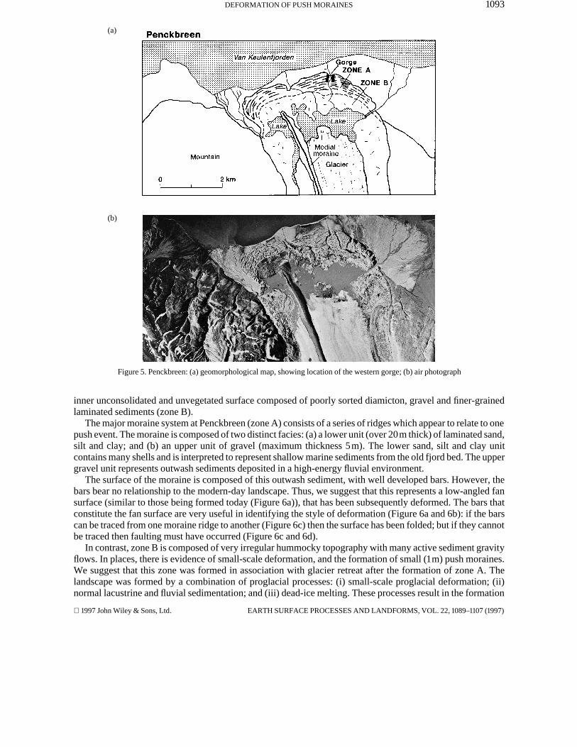
PENCKBREEN
This is the larger of the two glaciers and presently is melting into a lake held up between the moraines and theglacier front (Figure 5). The foreland consists of two areas of differing sedimentology, structural geology andland surface consolidation: (a) an outer consolidated gravel surface with some lichen cover (zone A); and (b) an
1997 John Wiley & Sons, Ltd. EARTH SURFACE PROCESSES AND LANDFORMS, VOL. 22, 1089–1107 (1997)
1092 J. K. HART AND R. J. WATTS
Figure 3. Lichenometry curve after Werner (1990)
Figure 4. Schematic diagram to show how to calculate age of deformation events from lichen data (see text for details)
EARTH SURFACE PROCESSES AND LANDFORMS, VOL. 22, 1089–1107 (1997) 1997 John Wiley & Sons, Ltd.
1093DEFORMATION OF PUSH MORAINES
(a)
(b)
Figure 5. Penckbreen: (a) geomorphological map, showing location of the western gorge; (b) air photograph
inner unconsolidated and unvegetated surface composed of poorly sorted diamicton, gravel and finer-grainedlaminated sediments (zone B).
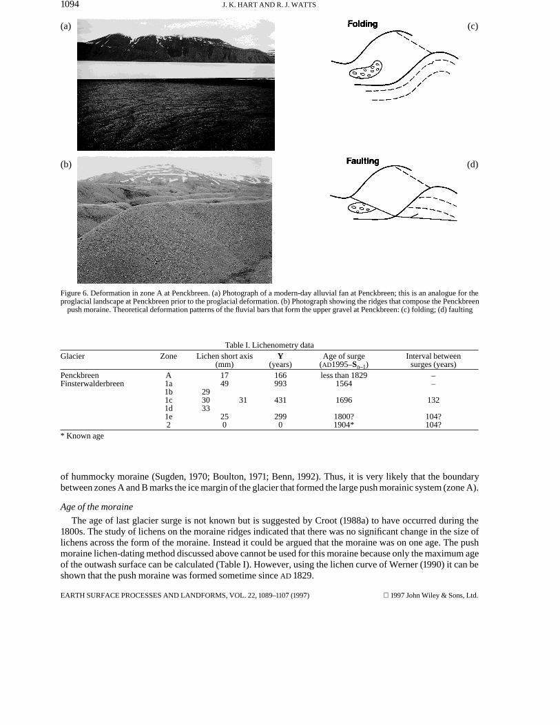
The major moraine system at Penckbreen (zone A) consists of a series of ridges which appear to relate to onepush event. The moraine is composed of two distinct facies: (a) a lower unit (over 20m thick) of laminated sand,silt and clay; and (b) an upper unit of gravel (maximum thickness 5m). The lower sand, silt and clay unitcontains many shells and is interpreted to represent shallow marine sediments from the old fjord bed. The uppergravel unit represents outwash sediments deposited in a high-energy fluvial environment.
The surface of the moraine is composed of this outwash sediment, with well developed bars. However, thebars bear no relationship to the modern-day landscape. Thus, we suggest that this represents a low-angled fansurface (similar to those being formed today (Figure 6a)), that has been subsequently deformed. The bars thatconstitute the fan surface are very useful in identifying the style of deformation (Figure 6a and 6b): if the barscan be traced from one moraine ridge to another (Figure 6c) then the surface has been folded; but if they cannotbe traced then faulting must have occurred (Figure 6c and 6d).
In contrast, zone B is composed of very irregular hummocky topography with many active sediment gravityflows. In places, there is evidence of small-scale deformation, and the formation of small (1m) push moraines.We suggest that this zone was formed in association with glacier retreat after the formation of zone A. Thelandscape was formed by a combination of proglacial processes: (i) small-scale proglacial deformation; (ii)normal lacustrine and fluvial sedimentation; and (iii) dead-ice melting. These processes result in the formation
1997 John Wiley & Sons, Ltd. EARTH SURFACE PROCESSES AND LANDFORMS, VOL. 22, 1089–1107 (1997)
1094 J. K. HART AND R. J. WATTS
(a) (c)
(b) (d)
Figure 6. Deformation in zone A at Penckbreen. (a) Photograph of a modern-day alluvial fan at Penckbreen; this is an analogue for theproglacial landscape at Penckbreen prior to the proglacial deformation. (b) Photograph showing the ridges that compose the Penckbreen
push moraine. Theoretical deformation patterns of the fluvial bars that form the upper gravel at Penckbreen: (c) folding; (d) faulting
Table I. Lichenometry dataGlacier Zone Lichen short axis
(mm)Y
(years)Age of surge
(AD1995–Sn–1)Interval between
surges (years)Penckbreen A 17 166 less than 1829 –Finsterwalderbreen 1a 49 993 1564 –
1b 291c 30 31 431 1696 1321d 331e 25 299 1800? 104?2 0 0 1904* 104?
* Known age
of hummocky moraine (Sugden, 1970; Boulton, 1971; Benn, 1992). Thus, it is very likely that the boundarybetween zones A and B marks the ice margin of the glacier that formed the large push morainic system (zone A).
Age of the moraine
The age of last glacier surge is not known but is suggested by Croot (1988a) to have occurred during the1800s. The study of lichens on the moraine ridges indicated that there was no significant change in the size oflichens across the form of the moraine. Instead it could be argued that the moraine was on one age. The pushmoraine lichen-dating method discussed above cannot be used for this moraine because only the maximum ageof the outwash surface can be calculated (Table I). However, using the lichen curve of Werner (1990) it can beshown that the push moraine was formed sometime since AD 1829.
EARTH SURFACE PROCESSES AND LANDFORMS, VOL. 22, 1089–1107 (1997) 1997 John Wiley & Sons, Ltd.
1095DEFORMATION OF PUSH MORAINES
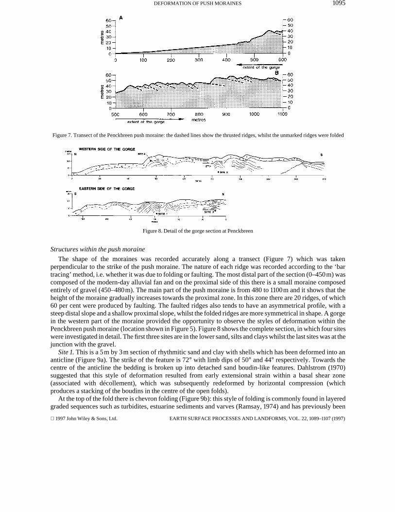
Figure 7. Transect of the Penckbreen push moraine: the dashed lines show the thrusted ridges, whilst the unmarked ridges were folded
Figure 8. Detail of the gorge section at Penckbreen
Structures within the push moraine
The shape of the moraines was recorded accurately along a transect (Figure 7) which was takenperpendicular to the strike of the push moraine. The nature of each ridge was recorded according to the ‘bartracing’ method, i.e. whether it was due to folding or faulting. The most distal part of the section (0–450m) wascomposed of the modern-day alluvial fan and on the proximal side of this there is a small moraine composedentirely of gravel (450–480m). The main part of the push moraine is from 480 to 1100m and it shows that theheight of the moraine gradually increases towards the proximal zone. In this zone there are 20 ridges, of which60 per cent were produced by faulting. The faulted ridges also tends to have an asymmetrical profile, with asteep distal slope and a shallow proximal slope, whilst the folded ridges are more symmetrical in shape. A gorgein the western part of the moraine provided the opportunity to observe the styles of deformation within thePenckbreen push moraine (location shown in Figure 5). Figure 8 shows the complete section, in which four siteswere investigated in detail. The first three sites are in the lower sand, silts and clays whilst the last sites was at thejunction with the gravel.
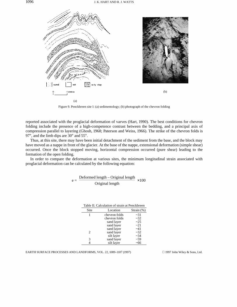
Site 1. This is a 5m by 3m section of rhythmitic sand and clay with shells which has been deformed into ananticline (Figure 9a). The strike of the feature is 72° with limb dips of 50° and 44° respectively. Towards thecentre of the anticline the bedding is broken up into detached sand boudin-like features. Dahlstrom (1970)suggested that this style of deformation resulted from early extensional strain within a basal shear zone(associated with décollement), which was subsequently redeformed by horizontal compression (whichproduces a stacking of the boudins in the centre of the open folds).
At the top of the fold there is chevron folding (Figure 9b): this style of folding is commonly found in layeredgraded sequences such as turbidites, estuarine sediments and varves (Ramsay, 1974) and has previously been
1997 John Wiley & Sons, Ltd. EARTH SURFACE PROCESSES AND LANDFORMS, VOL. 22, 1089–1107 (1997)
1096 J. K. HART AND R. J. WATTS
(a)
(b)
Figure 9. Penckbreen site 1: (a) sedimentology; (b) photograph of the chevron folding
reported associated with the proglacial deformation of varves (Hart, 1990). The best conditions for chevronfolding include the presence of a high-competence contrast between the bedding, and a principal axis ofcompression parallel to layering (Ghosh, 1968; Paterson and Weiss, 1966). The strike of the chevron folds is97°, and the limb dips are 30° and 55°.
Thus, at this site, there may have been initial detachment of the sediment from the base, and the block mayhave moved as a nappe in front of the glacier. At the base of the nappe, extensional deformation (simple shear)occurred. Once the block stopped moving, horizontal compression occurred (pure shear) leading to theformation of the open folding.
In order to compare the deformation at various sites, the minimum longitudinal strain associated withproglacial deformation can be calculated by the following equation:
e =Deformed length – Original length
Original length×100
Table II. Calculation of strain at PenckbreenSite Location Strain (%)
1 chevron folds −31chevron folds −32
sand layer −25sand layer −21sand layer −41
2 sand layer −32silt layer −34
3 sand layer −594 silt layer −66
EARTH SURFACE PROCESSES AND LANDFORMS, VOL. 22, 1089–1107 (1997) 1997 John Wiley & Sons, Ltd.
1097DEFORMATION OF PUSH MORAINES
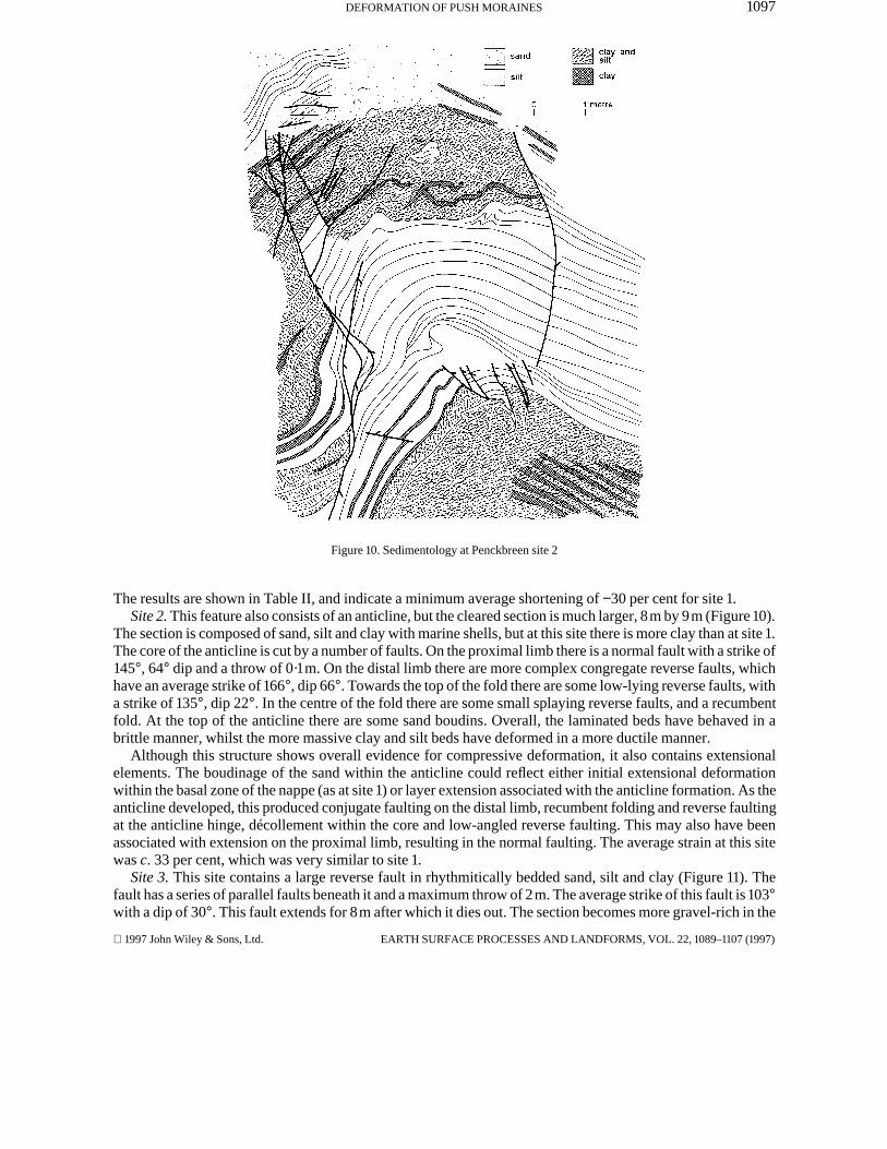
Figure 10. Sedimentology at Penckbreen site 2
The results are shown in Table II, and indicate a minimum average shortening of −30 per cent for site 1.Site 2. This feature also consists of an anticline, but the cleared section is much larger, 8m by 9m (Figure 10).
The section is composed of sand, silt and clay with marine shells, but at this site there is more clay than at site 1.The core of the anticline is cut by a number of faults. On the proximal limb there is a normal fault with a strike of145°, 64° dip and a throw of 0·1m. On the distal limb there are more complex congregate reverse faults, whichhave an average strike of 166°, dip 66°. Towards the top of the fold there are some low-lying reverse faults, witha strike of 135°, dip 22°. In the centre of the fold there are some small splaying reverse faults, and a recumbentfold. At the top of the anticline there are some sand boudins. Overall, the laminated beds have behaved in abrittle manner, whilst the more massive clay and silt beds have deformed in a more ductile manner.
Although this structure shows overall evidence for compressive deformation, it also contains extensionalelements. The boudinage of the sand within the anticline could reflect either initial extensional deformationwithin the basal zone of the nappe (as at site 1) or layer extension associated with the anticline formation. As theanticline developed, this produced conjugate faulting on the distal limb, recumbent folding and reverse faultingat the anticline hinge, décollement within the core and low-angled reverse faulting. This may also have beenassociated with extension on the proximal limb, resulting in the normal faulting. The average strain at this sitewas c. 33 per cent, which was very similar to site 1.
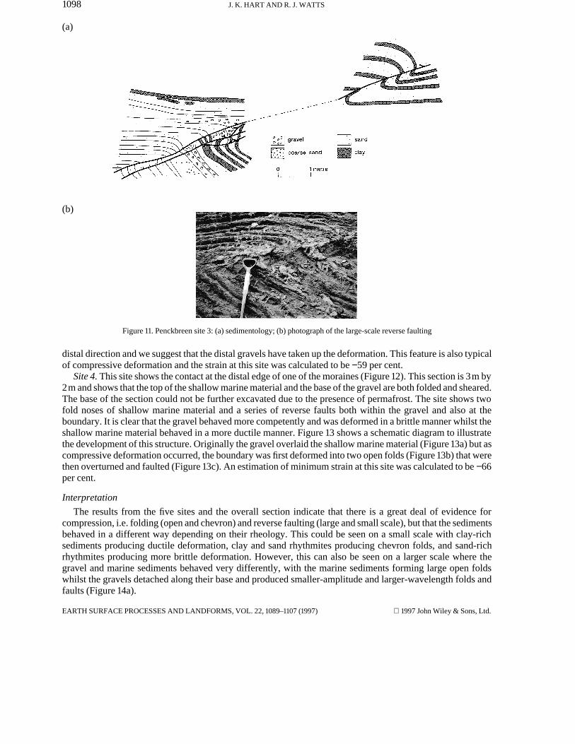
Site 3. This site contains a large reverse fault in rhythmitically bedded sand, silt and clay (Figure 11). Thefault has a series of parallel faults beneath it and a maximum throw of 2m. The average strike of this fault is 103°with a dip of 30°. This fault extends for 8m after which it dies out. The section becomes more gravel-rich in the
1997 John Wiley & Sons, Ltd. EARTH SURFACE PROCESSES AND LANDFORMS, VOL. 22, 1089–1107 (1997)
1098 J. K. HART AND R. J. WATTS
(a)
(b)
Figure 11. Penckbreen site 3: (a) sedimentology; (b) photograph of the large-scale reverse faulting
distal direction and we suggest that the distal gravels have taken up the deformation. This feature is also typicalof compressive deformation and the strain at this site was calculated to be −59 per cent.
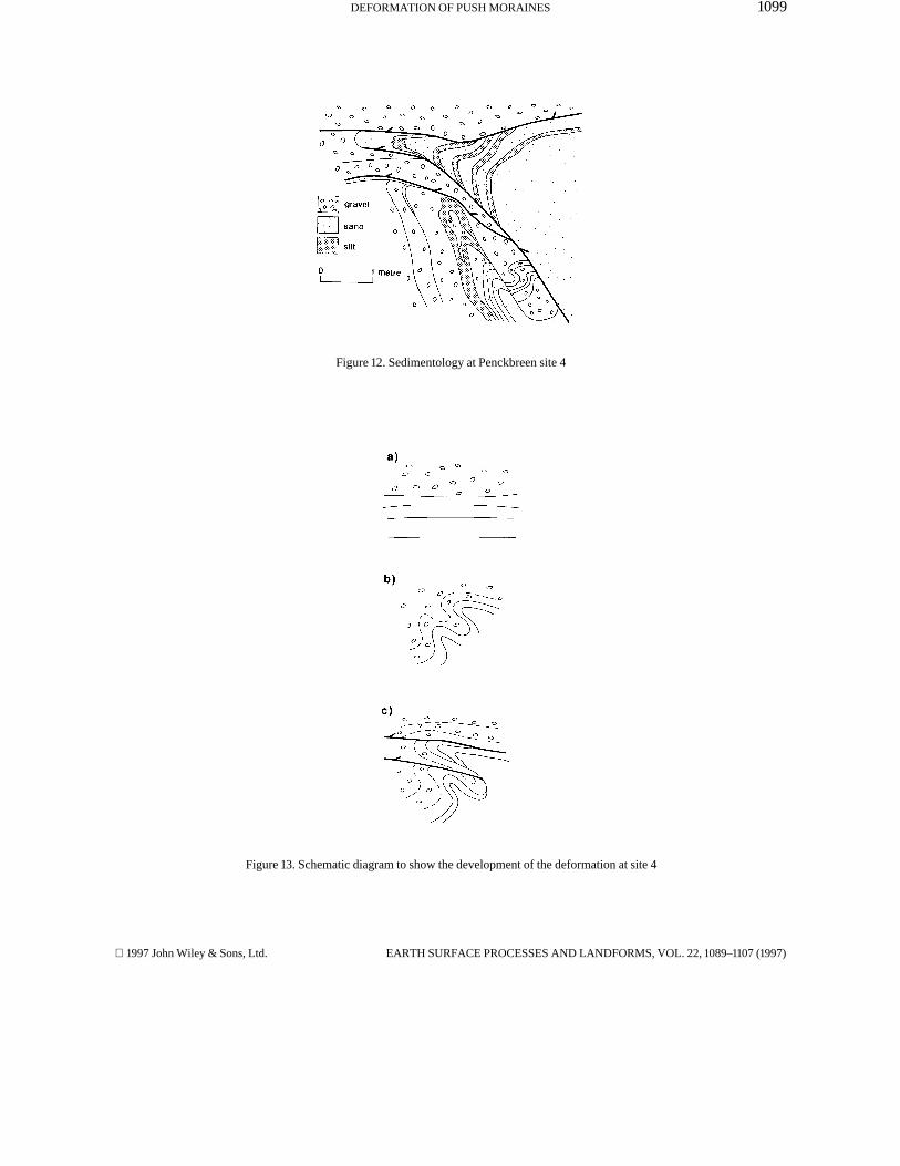
Site 4. This site shows the contact at the distal edge of one of the moraines (Figure 12). This section is 3m by2m and shows that the top of the shallow marine material and the base of the gravel are both folded and sheared.The base of the section could not be further excavated due to the presence of permafrost. The site shows twofold noses of shallow marine material and a series of reverse faults both within the gravel and also at theboundary. It is clear that the gravel behaved more competently and was deformed in a brittle manner whilst theshallow marine material behaved in a more ductile manner. Figure 13 shows a schematic diagram to illustratethe development of this structure. Originally the gravel overlaid the shallow marine material (Figure 13a) but ascompressive deformation occurred, the boundary was first deformed into two open folds (Figure 13b) that werethen overturned and faulted (Figure 13c). An estimation of minimum strain at this site was calculated to be −66per cent.
Interpretation
The results from the five sites and the overall section indicate that there is a great deal of evidence forcompression, i.e. folding (open and chevron) and reverse faulting (large and small scale), but that the sedimentsbehaved in a different way depending on their rheology. This could be seen on a small scale with clay-richsediments producing ductile deformation, clay and sand rhythmites producing chevron folds, and sand-richrhythmites producing more brittle deformation. However, this can also be seen on a larger scale where thegravel and marine sediments behaved very differently, with the marine sediments forming large open foldswhilst the gravels detached along their base and produced smaller-amplitude and larger-wavelength folds andfaults (Figure 14a).
EARTH SURFACE PROCESSES AND LANDFORMS, VOL. 22, 1089–1107 (1997) 1997 John Wiley & Sons, Ltd.
1099DEFORMATION OF PUSH MORAINES
Figure 12. Sedimentology at Penckbreen site 4
Figure 13. Schematic diagram to show the development of the deformation at site 4
1997 John Wiley & Sons, Ltd. EARTH SURFACE PROCESSES AND LANDFORMS, VOL. 22, 1089–1107 (1997)
1100 J. K. HART AND R. J. WATTS
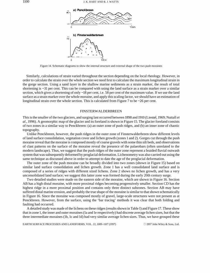
Figure 14. Schematic diagrams to show the internal structure and external shape of the two push moraines
Similarly, calculations of strain varied throughout the section depending on the local rheology. However, inorder to calculate the strain over the whole section we need first to calculate the maximum longitudinal strain inthe gorge section. Using a sand layer in the shallow marine sediments as a strain marker, the result of totalshortening is −31 per cent. This can be compared with using the land surface as a strain marker over a similarsection, which gives a shortening of only −18 per cent, i.e. 58 per cent of the maximum value. If we use the landsurface as a strain marker over the whole moraine, and apply this scaling factor, we should have an estimation oflongitudinal strain over the whole section. This is calculated from Figure 7 to be −26 per cent.
FINSTERWALDERBREEN
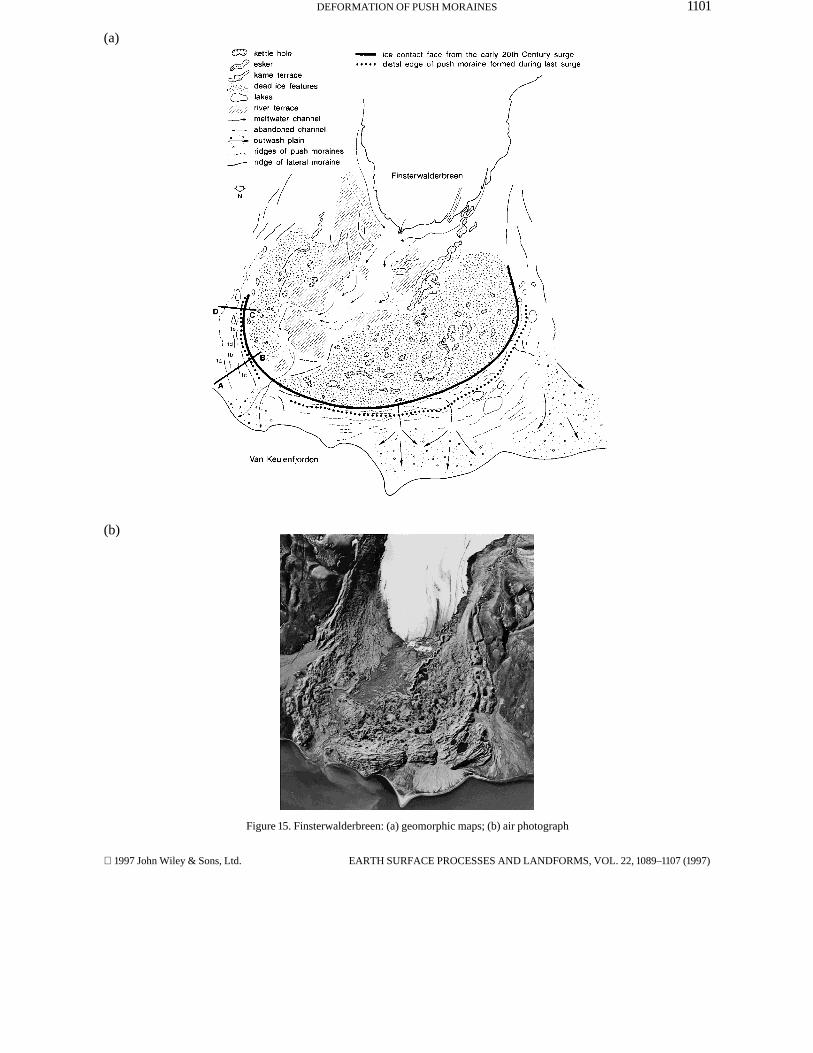
This is the smaller of the two glaciers, and surging last occurred between 1898 and 1910 (Liestøl, 1969; Nuttall etal., 1996). A geomorphic map of the glacier and its foreland is shown in Figure 15. The glacier foreland consistsof two zones in a similar way to Penckbreen: (a) an outer zone of push ridges, and (b) an inner zone of chaotictopography.
Unlike Penckbreen, however, the push ridges in the outer zone of Finsterwalderbreen show different levelsof land surface consolidation, vegetation cover and lichen growth (zones 1 and 2). Gorges cut through the pushmoraine reveal that the moraine is composed mostly of coarse gravels with some thin silt beds, and observationsof clast patterns on the surface of the moraine reveal the presence of the palaeobars (often unrelated to themodern landscape). Thus, we suggest that the push ridges of the outer zone represent a braided fluvial outwashsystem that was subsequently deformed by proglacial deformation. Lichenometry was also carried out using thesame technique as discussed above in order to attempt to date the age of the proglacial deformation.
The outer zone of the push moraine can be broadly divided into two zones (shown in Figure 15) based onsimilar land surface consolidation and lichen growth. Zone 1 has a well consolidated land surface and iscomposed of a series of ridges with different sized lichens. Zone 2 shows no lichen growth, and has a veryunconsolidated land surface; we suggest this latter zone was formed during the early 20th century surge.
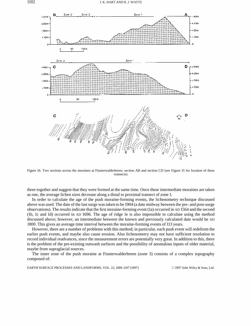
Two detailed studies were made on the eastern side of the moraine, which are shown in Figure 16. SectionAB has a high distal moraine, with more proximal ridges becoming progressively smaller. Section CD has thehighest ridge in a more proximal position and contains only three distinct subzones. Section AB may havesuffered distal marine erosion, and probably the true shape of the moraine is similar to that shown schematicallyin Figure 16. Since the moraine was composed mostly of gravel, large-scale structures were not present as atPenckbreen. However, from the surface, using the ‘bar tracing’ methods it was clear that both folding andfaulting had occurred.
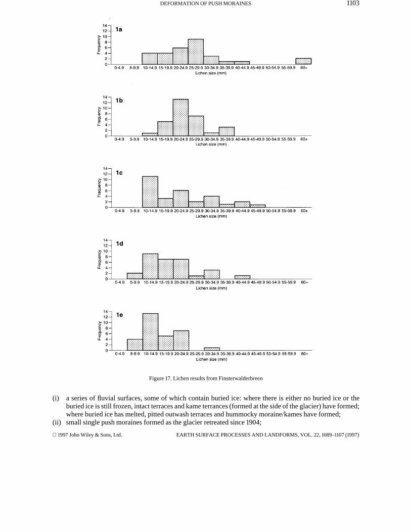
A detailed study was made of the lichens on these ridges (results shown in Table I) and Figure 17. These showthat in zone 1, the inner and outer moraines (1a and 1e respectively) had discrete average lichen sizes, but that thethree intermediate moraines (1b, 1c and 1d) had very similar average lichen sizes. Thus, we have grouped these
EARTH SURFACE PROCESSES AND LANDFORMS, VOL. 22, 1089–1107 (1997) 1997 John Wiley & Sons, Ltd.
1101DEFORMATION OF PUSH MORAINES
(a)
(b)
Figure 15. Finsterwalderbreen: (a) geomorphic maps; (b) air photograph
1997 John Wiley & Sons, Ltd. EARTH SURFACE PROCESSES AND LANDFORMS, VOL. 22, 1089–1107 (1997)
1102 J. K. HART AND R. J. WATTS
Figure 16. Two sections across the moraines at Finsterwalderbreen: section AB and section CD (see Figure 15 for location of thesetransects)
three together and suggest that they were formed at the same time. Once these intermediate moraines are takenas one, the average lichen sizes decrease along a distal to proximal transect of zone 1.
In order to calculate the age of the push moraine-forming events, the lichenometry technique discussedabove was used. The date of the last surge was taken to be 1904 (a date midway between the pre- and post-surgeobservations). The results indicate that the first moraine-forming event (1a) occurred in AD 1564 and the second(1b, 1c and 1d) occurred in AD 1696. The age of ridge 1e is also impossible to calculate using the methoddiscussed above; however, an intermediate between the known and previously calculated date would be AD
1800. This gives an average time interval between the moraine-forming events of 113 years.However, there are a number of problems with this method; in particular, each push event will redeform the
earlier push events, and maybe also cause erosion. Also lichenometry may not have sufficient resolution torecord individual readvances, since the measurement errors are potentially very great. In addition to this, thereis the problem of the pre-existing outwash surfaces and the possibility of anomalous inputs of older material,maybe from supraglacial sources.
The inner zone of the push moraine at Finsterwalderbreen (zone 3) consists of a complex topographycomposed of:
EARTH SURFACE PROCESSES AND LANDFORMS, VOL. 22, 1089–1107 (1997) 1997 John Wiley & Sons, Ltd.
1103DEFORMATION OF PUSH MORAINES
Figure 17. Lichen results from Finsterwalderbreen
(i) a series of fluvial surfaces, some of which contain buried ice: where there is either no buried ice or theburied ice is still frozen, intact terraces and kame terrances (formed at the side of the glacier) have formed;where buried ice has melted, pitted outwash terraces and hummocky moraine/kames have formed;
(ii) small single push moraines formed as the glacier retreated since 1904;
1997 John Wiley & Sons, Ltd. EARTH SURFACE PROCESSES AND LANDFORMS, VOL. 22, 1089–1107 (1997)
1104 J. K. HART AND R. J. WATTS
(iii) a large esker which was exposed after 1970.
Because the deformed outwash gravel at Finsterwalderbreen contains no continuous record of the bedding,strain could only be estimated from the moraine land surface. Using the scaling technique found fromPenckbreen, the strain over section CD is −20 per cent and over section AB −44 per cent, so the average strainwas calculated to be −32 per cent.
DISCUSSION
Penckbreen and Finsterwalderbreen are adjacent glaciers with similarly extensive push moraines; however,they show important differences. The Penckbreen moraine was formed during one push event which deformedshallow marine and outwash sediments into a series of upright and overturned open folds. In general, thedeformation decreased down-ice (except in local areas, e.g. site 4), with marine and fluvial sedimentsresponding differently to the gravel because of their different rheological properties. This produced a pushmoraine 650m long. We suggest that this large moraine was formed because the shallow marine sedimentswere relatively weak and because of the presence of a basal décollement surface in the shallow marinesediments.
This moraine is very similar to that observed at Holmströmbreen by Boulton et al. (1989), which was formedby one large push event and had a basal unit of shallow marine muds, silts and sands. The push moraine atHolmströmbreen was formed during a surge in 1890, and it is very likely that Penckbreen was formed during asimilar surge in the early 19th century. Since there is no record of any previous surging recorded in thesesediments (or those at Holmströmbreen), the nature or ages of previous surges is not known.
In contrast, the Finsterwalderbreen moraine was formed as the result of a series of advances. From historicalrecords it is known that the glacier surged in the early 20th century, but the nature of the early readvances is notknown. It is known that push moraines form in front of both surging and non-surging glaciers (Eybergen, 1987;van der Wateren, 1987; Hart, 1990; Etzelmüller et al., 1996; Hambrey et al., 1996), and it has also been arguedthat surging glaciers do not produce unique landscapes (Hart, 1996b). However, it can be seen that eachreadvance event reached a similar location, which may reflect a surge rather than a climatically drivenreadvance (which may have reached different locations in the foreland reflecting different climatic changes). Ifwe assume that these readvances do reflect surges then from the lichenometry data we can suggest that theseoccurred on an average time interval of 113 years. It is very likely that this is an overestimation because of theproblems with the lichenometry technique. However, Penckbreen has a similarly long quiescent period since ithas not surged since the early 19th century (maximum time since surge, 166 years).
The results are similar to those of Dowdeswell et al. (1991) who suggested that Svalbard glaciers have alonger surge duration than glaciers in other parts of the world, with lower velocities and a longer quiescentperiod. Liestøl (in press) reported 50 years for Turnabreen, 70 years for Hambergbreen and 110 years forRecherchebreen. However, Svalbard was the only high-arctic region investigated so they could not determine ifthis longer duration was due simply to low temperatures or to other factors.
At Finsterwalderbreen, the surge events were more localized and only affected outwash sediments. Wesuggest that each surge moraine was much shorter at Finsterwalderbreen because: (a) the outwash sedimentsare far more competent than the shallow marine sediments; (b) there was no laterally extensive fine-grainedbasal décollement surface; and (c) there was a large obstacle to deformation in the form of the previous pushmoraine.
A similar push moraine composed of asynchronous elements has been found at Usherbreen, Svalbard, and isdescribed by Etzelmüller et al. (1996). This moraine was finer-grained than Finsterwalderbreen, beingcomposed of sand-rich pebbles, pebbles, sandy loam, sand, silt, clay and ground/glacier ice. However, the mostrecent deformational event at this site caused deformation throughout the whole moraine belt, but caused newpush moraines to be formed at the distal end of the moraine belt. Additionally, the overall form of the pushmoraine at Finsterwalderbreen is very similar (although much larger) to the gravel-rich Turtmannglacier pushmoraine in Switzerland (Eybergen, 1987) (although that was formed in association with one push event).
EARTH SURFACE PROCESSES AND LANDFORMS, VOL. 22, 1089–1107 (1997) 1997 John Wiley & Sons, Ltd.
1105DEFORMATION OF PUSH MORAINES
The strains in the two sections were similar, −26 per cent at Penckbreen and −32 per cent atFinsterwalderbreen. These figures compare favourably with earlier estimates of strain from other sitesassociated with proglacial glaciotectonic deformation (see Table III).
Table III. Characteristics of various push morainesExample Strain (%)Penckbreen, Svalbard −26Finsterwalderbreen, Svalbard −32Holmströmbreen, Svalbard (Boulton et al., 1989) −43Eyjabakkajökull, Iceland (Croot 1988c) −46Melabakkar-Asbakkar, West Iceland (Hart, 1994) −32Trimingham, East Anglia, UK (Hart 1990) −32
CONCLUSION
This study showed that the push moraines at the two glaciers were formed in association with surges whichproduced a different style of moraine depending on the rheology and glacial history. The Penckbreen morainewas formed by one advance into a two-layer proglacial sequence. This sequence was composed of a lowershallow marine sand, silt and clay, and an upper fluvial sand and gravel. Deformation at this site led to theformation of large anticlines in the silts and clays, with disharmonic smaller folds and thrusts in the uppergravels, above a detachment surface between the fine-grained and overlying coarse-grained lithologies. Thisresulted in a longitudinally extensive push moraine, with a relatively low-amplitude (in the upper gravels)folded and thrusted surface. This style of push moraine is very common, and is very similar in size, deformationstyle and longitudinal strain to a number of others described in the literature, e.g. Holmströmbreen (Gripp, 1929;Boulton et al., 1989), Maktak glacier, Baffin Island (Boulton, 1986), Thompson glacier, Axel Heiberg (Kälin,1971; Lehmann, 1992) and Eyjabakkajökull, Iceland (Croot, 1988c).
In contrast, the push moraine at Finsterwalderbreen was more unusual in style. This was formed by a seriesof advances and was formed from the proglacial deformation of a previous outwash plain. This moraine wasmuch shorter in longitudinal extent, although of similar height to the Penckbreen moraine. We suggest that themoraine was less longitudinally extensive at Finsterwalderbreen because it was composed of a more competentmaterial than Penckbreen (i.e. a more gravel-rich lithology and without an obvious fine-grained décollementsurface), and the presence of previously formed push moraines. Although gravel-rich moraines have beenrecorded in the past (e.g. Turtmann glacier, Switzerland (Eybergen, 1987)), push moraines composed ofdifferent aged elements have received little attention (with the exception of Usherbreen). AtFinsterwalderbreen, it was shown that the surge events all reached a similar limit and occurred at regularintervals.
This study has highlighted the importance of sediment competence and glacial history in the formation ofpush moraines, and has shown how adjacent glaciers can produce different styles of moraine.
ACKNOWLEDGEMENTS
We would like to thank all members of the Department of Geography, Penckbreen 1994 expedition, especiallyKirk Martinez for tireless fieldwork assistance and photography, and Emma Lewis for the lichenometry; and allthose who helped with the successful running of the expedition, including Andy Hodson and JulianDowdeswell. We would also like to thank Tim Aspden and Alan Burn and their colleagues for figurereproduction, and Alan Burn and John Hurst for technical support. Thanks must also go to the Syssleman,Svalbard, for permission to carry out research in Svalbard. This research was funded by University ofSouthampton Grant 92/2.
1997 John Wiley & Sons, Ltd. EARTH SURFACE PROCESSES AND LANDFORMS, VOL. 22, 1089–1107 (1997)
1106 J. K. HART AND R. J. WATTS
REFERENCES
Aber, J. S. (Ed.) 1991. Glaciotectonics and Mapping Glacial Deposits, Canadian Plains Research Centre, Regina, 286–302.Aber, J. S. 1996. Bibliography of Glaciotectonic References, INQUA Work Group on Glacial Tectonics.Benn, D. 1992. ‘The genesis and significance of ‘‘hummocky moraine’’: evidence from the Isle of Sky, Scotland’, Quaternary Science
Reviews, 11, 781–799.Bennett, M. R., Huddart, M. and Ghienne, F. 1996. ‘Moraine development at the high-arctic valley glacier Pedersenbreen, Svalbard’,
Geografiska Annaler, 78A, 209–222.Boulton, G. S. 1971. ‘Till genesis and fabric in Svalbard, Spitsbergen’, in Goldthwaite, R. P. (Ed.), Till, A Symposium, Ohio State
University Press, 41–72.Boulton, G. S. 1986. ‘Push-moraines and glacier-contacts fans in marine and terrestrial environments’, Sedimentology, 33, 677–698.Boulton, G. S. and Jones, A. S. 1979. ‘Stability of temperate ice caps and ice sheets resting on beds of deformable sediment’, Journal of
Glaciology, 24, 29–44.Boulton, G. S., Meer, J. J. M. van der, Ruegg, G. H. J., Beets, D. J., Riezebos, P. A., Castel, I. I. Y., Hart, J., Quinn, I., Thornton, M.,
Wateren, F. M. van der, 1989. Preliminary Report on Glaciotecs ‘84, Report of the Fysisch Geografisch en BodemkundigLaboratorium, University of Amsterdam.
Clarke, G. K. C. 1987. ‘Subglacial till: A physical framework for its properties and processes’, Journal of Geophysical Research, 92(B9),8942–8984.
Croot, D. G. 1988a. ‘Glaciotectonics and surging glaciers: A correlation based on Vestspitsbergen, Svalbard, Norway’, in Croot, D. (Ed.),Glaciotectonics: Forms and Processes, Balkema, Rotterdam, 49–61.
Croot, D. G. (Ed.) 1988b. Glaciotectonics: Forms and Processes, Balkema, Rotterdam, 212 pp.Croot, D. G. 1988c. ‘Morphological, structural and mechanical analysis of neoglacial ice-pushed ridges in Iceland’, in Croot, D. (Ed.),
Glaciotectonics: Forms and Processes, Balkema, Rotterdam, 33–48.Dahlstrom, C. D. A. 1970. ‘Structural geology in the eastern margin of the Canadian Rocky Mountains’, Bulletin of Canadian Petroleum
Geology, 18, 332–406.Dowdeswell, J. A., Hamilton, G. S. and Ove Hagen, J. 1991. ‘The duration of the active phase on surge-type glaciers: contrasts between
Svalbard and other regions’, Journal of Glaciology, 37, 388–400.Etzemüller, B., Hagan, J. O., Vatne, G., Ødegård, R. S. and Sollid, J. L. 1996. ‘Glacier debris accumulation and sediment deformation
influenced by permafrost: examples from Svalbard’, Annals of Glaciology, 22, 63–62.Eybergen, F. A. 1987. ‘Glacier snout dynamics and contemporary push moraine formation at the Turtmannglacier, Wallis, Switzerland’,
in van der Meer, J. J. M. (Ed.), Tills and Glaciotectonics, Balkema, Rotterdam, 217–234.Ghosh, S. K. 1968. ‘Experiments of buckling of multilayers which permit interlayer gliding’, Tectnophysics, 6, 207–250.Gripp, K. 1929. ‘Glaziologische und geologische Ergebnisse der Hamburgischen Spitzbergen-Ekspedition 1927’, Abhandlungen des
Naturwissenschaftlichen Vereins in Hamburg, 22, 147–247 (translated into English by J. J. M. van der Meer).Hambrey, M. J. and Huddart, D. 1995. ‘Englacial and proglacial glaciotectonic processes at the snout of a thermally complex glacier in
Svalbard’, Journal of Quaternary Science, 10, 313–327.Hambrey, M. J., Dowdeswell, J. A., Murray, T. and Porter, P. R. 1996. ‘Thrusting and debris-entrainment in a surging glacier:
Bakaninbreen, Svalbard’, Annals of Glaciology, 22, 241–248.Hart, J. K. 1990. ‘Proglacial glaciotectonic deformation and the origin of the Cromer Ridge push moraine complex, North Norfolk, U.K.’,
Boreas, 19, 165–180.Hart, J. K. 1994. ‘Proglacial glaciotectonic deformation at Melabakkar-Asbakkar, west Iceland’, Boreas, 23, 112–121.Hart, J. K. 1995. ‘An investigation of the deforming layer/debris-rich ice continuum, illustrated from three Alaskan glaciers’, Journal of
Glaciology, 41, 619–633.Hart, J. K. 1996a. ‘Proglacial glaciotectonic deformation associated with glaciolacustrine sedimentation, Lake Pukaki, New Zealand’,
Journal of Quaternary Research, 11, 149–160.Hart, J. K. 1996b. Alaska Expedition 1995, Department of Geography, University of Southampton, Discussion Paper, 40, 161 pp.Hart, J. K. and Boulton, G. S. 1991. ‘The interrelationship between glaciotectonic deformation and glaciodeposition within the glacial
environment’, Quaternary Science Reviews, 10, 335–350.Ingólfsson, Ó. 1988. Large-scale glaciotectonic deformation of soft sediments: A case study of a late Weichselian sequence in western
Iceland’, in Croot, D. G. (Ed.), Glaciotectonic Forms and Processes, Balkema, Rotterdam, 101–107.Kälin, M. 1971. ‘The active push moraine of the Thompson Glacier, Axel Heiberg Island Research Report, McGill University, Montreal’,
Glaciology, 4, 86 pp.Lehmann, R. 1992. ‘Arctic push moraines, a case study of the Thompson Glacier Moraine, Axel Heiberg Island, N. W. T., Canada’,
Zeitschrift fur Geomorphologie, N. F. 86, 161–171.Liestøl, O. 1969. ‘Glacier surges in West Spitsbergen’, Canadian Journal of Earth Sciences, 6, 895–897.Liestøl, O. (in press). Glaciers of Svalbard, Norway, US Geological Survey of Professional Paper, 1396, Chapter 5E.Locke, W. W., III, Andrews, J. T. and Webber, P. J. 1979. ‘A manual for lichenometry’, British Geomorphological Research Group
Technical Bulletin, 26, 48 pp.Meer, van der J. M. M. (Ed.) 1987. Tills and Glaciotectonics, Balkema, Rotterdam.Nuttall, A. -M., Hagen, J. O. and Dowdeswell, J. A. 1996. ‘Quiescent-phase surge-type glacier: Finsterwalderbreen; I: changes in velocity
and geometry’, in Dowdeswell, J. A. and Nuttall, A. -M. (Eds), Investigations of Glacier Surges: Measurements and Modelling of IceDynamics in Svalbard, European Arctic, Centre for Glaciology, Report, 96–2, 46–55.
Paterson, M. S. and Weiss, L. E. 1966. ‘Experimental deformation and folding in phyllite’, Geological Society of America Bulletin, 77,343–374.
Ramsay, J. G. 1974. ‘Development of chevron folds’, Geological Society of America Bulletin, 85, 1741–1754.
EARTH SURFACE PROCESSES AND LANDFORMS, VOL. 22, 1089–1107 (1997) 1997 John Wiley & Sons, Ltd.

1107DEFORMATION OF PUSH MORAINES
Sugden, D. E. 1970. ‘Landforms of deglaciation in the Cairngorm Mountains, Scotland’, Transactions of the Institute of BritishGeographers, 51, 201–219.
Thomas, G. S. P. 1984. ‘The origin of the glacio-dynamic structure of the Bride Moraine, Isle of Man’, Boreas, 13, 355–364.Wateren, van der F. M. 1987. ‘Structural geology and sedimentology of the Dammer Berge push moraine, FRG., in J. J. M. van der Meer
(Ed.), Tills and Glaciotectonics, Balkema, Rotterdam, 157–182.Werner, A. 1990. ‘Lichen growth rates for the northwest coast of Spitsbergen, Svalbard’, Arctic and Alpine Research, 22, 129–140.
1997 John Wiley & Sons, Ltd. EARTH SURFACE PROCESSES AND LANDFORMS, VOL. 22, 1089–1107 (1997)