Embed Size (px)
Citation preview
www.fastionline.org/docs/FOLDER-it-2014-314.pdf
The Journal of Fasti Online (ISSN 1828-3179) ● Published by the Associazione Internazionale di Archeologia Classica ● Piazza San Marco, 49 – I-00186 Roma ● Tel. / Fax: ++39.06.67.98.798 ● http://www.aiac.org; http://www.fastionline.org
A Forgotten Roman Settlement in the Veneto. University of Kentucky Geoarchaeological Investigations
at Tezze di Arzignano (Vicenza, Italy) in 2012
Paolo Visonà
with George M. Crothers – Justin N. Carlson – Donald L. Handshoe – Silvana Lora – P. Allegra Rasia – Luana Toniolo*
The results of a geophysical survey at località Valbruna near Tezze di Arzignano (VI), in Italy’s western Veneto, cast new light on a Roman site that has never been systematically investigated. Conspicuous remains of houses possibly belonging to a large Roman settlement were uncovered in this area in 1795 and 1882 after major river floods. Among a series of buried anomalies revealed by gradiometer and GPR data, a rectangular wall-like feature (corresponding on the surface with a cluster of roof tiles and mosaic tesserae) has been interpreted as a portion of a Roman building. Another significant anomaly has been tentatively identified as an ancient roadway. Several small, pit-like anomalies found at a lower depth than these installations have affinities with prehistoric features but cannot be conclusively explained without further testing. There are indications that this building, whose size and functions could not be determined, may have been located near a burial ground outside the main settlement. The dating of the pottery recovered from the survey area suggests that the site was continuously occupied from the final phase of the late Iron age until the 3
rd century A.D.
Introduction
The Agno Valley extends for 32.09 km in a north-northwest to south-southeast direction from the headwaters of the Agno River at Passo di Buse Scure to Tezze di Arzignano, a village to the north-west of Vicenza, in Italy’s Veneto region (fig. 1). Only near Tezze, where two small tributaries (the Arpega and the Restena) join the Agno to form the Guà Riv-er, does the valley widen beyond 2 km from east to west (fig. 2)
1. Sporadically frequented along its
length from the Mesolithic to the end of the Iron age, this enclave has yielded numerous Roman materials
* G.M. Crothers is Associate Professor in the Department of Anthropology at the University of Kentucky; J.N. Carlson is a doctoral stu-dent in the Department of Anthropology at the University of Kentucky; D.L. Handshoe is a graduate of the Department of Anthropology at the University of Kentucky; S. Lora is an independent scholar from Valdagno (Vicenza); P.A. Rasia is a graduate of the Dipartimento di Antropologia, Università degli Studi di Venezia Ca’ Foscari; L. Toniolo, Ph.D., is affiliated with the Dipartimento di Archeologia, Università degli Studi di Venezia Ca’ Foscari; P. Visonà is Associate Professor Adjunct in the School of Art and Visual Studies at the University of Kentucky. 1 See MILIANI 1939: 42-46; 53-58; FABIANI 1920: 13-14; ZANON 2002: 115-116. For the names Agno, Arpega, and Restena (first attested
in 1179, 1282, and 1288, respectively) see CHILESE 2003a: 26; CHILESE 2003b: 404-407; CHILESE 2009: 564-568, 621-622 and 634. “A Tezze, a partire dal punto di confluenza con il Restena, l’Agno cambia la denominazione in quella di Guà”, according to ZANON 2002: 115 (following MILIANI 1939: 46).
Fig. 1. The Agno River Valley. From ZANON 2002: 124. Computer-aided enhancement by L.F. Chapman.
Paolo Visonà with George M. Crothers, Justin N. Carlson, Donald L. Handshoe, Silvana Lora, P. Allegra Rasia, and Luana Toniolo ● A Forgotten Roman Set-
tlement in the Veneto. University of Kentucky Geoarchaeological Investigations at Tezze di Arzignano (Vicenza, Italy) in 2012
www.fastionline.org/docs/FOLDER-it-2014-314.pdf 2
Fig. 2. Satellite view of the Agno Valley at Tezze di Arzignano (in the foreground) on July 7, 2000. Courtesy of Google Earth. Visualization by J.R. Jansson.
and has been continuously inhabited since the 13
th
century A.D. (fig. 3). The extent to which it was set-tled in Roman and late antiquity, however, is still un-known
2. Scant information from Latin epigraphic
sources has led scholars to hypothesize that the Dripsinates, an indigenous people, lived in the lower Agno Valley and had their main settlement in the vi-cinity of Trissino, a small town 3 km to the north of Tezze, whose name has preserved the Dripsinates’ root word. According to the historian and topogra-pher P. Fraccaro, they were among the Latini iuris Euganeae gentes mentioned by the Elder Pliny (NH 3.133) and occupied the mountainous hinterland to the northwest of Vicenza at the beginning of the Em-pire
3. Their name has also been linked to the
ence of Celts, who interacted with local Raetian and Venetic populations in this liminal corner of the neto from the end of the 5
th century B.C. onwards
4.
Inscriptional evidence indicates that the Dripsinates may have acquired political autonomy by the 1
st cen-
tury A.D., as did other indigenous communities in northern Italy. Their citizens were enrolled in the Collina tribe (whereas the Roman citizens of Vicetia and its territory belonged to the Menenia tribe), and
2 MIGLIAVACCA 2002. For a glance at the distribution of the prehistoric and Roman sites known in the Agno Valley by the late 1980s see
CAV II: 21 and 97, F. 49; for early Medieval settlements see FORNASA 2000, CHILESE 2009: 631-633, and FORNASA 2012: 12, 17-21. 3 FRACCARO 1957 (followed by TALBERT 2000, I: 589 and Map 40). S. Maffei first proposed in 1732 that the Dripsinates were among the
dwellers of the “Valle di Trissino”, as the Agno Valley was named until the late 19th century (CHILESE 2003a: 41; cf. TESSARI 1884: 45,
and CHILESE 2009: 633). See also GARDUCCI VELO undated, Fasc. IV, p. 36, n. 8 (“i Dripsinates a Trissino e nella val d’Agno”). 4 Thus CHILESE 2003b: 483-484 and CHILESE 2009: 634. Chilese believes that the word Tezze is also of Celtic origin. G. Da Schio clai-
med that the Dripsinates were Celts: “i Drepsinati […] sono Galli tra quelli che furono seguaci dei Romani”; see DA SCHIO 1863: 68 and 104. For the presence of Celts at nearby Montebello Vicentino see RUTA SERAFINI 1997: 545-546; GAMBACURTA, RUTA SERAFINI 2001: 188-189; BONDINI 2005; GAMBARI, BONDINI 2013: 158.
Fig. 3. Distribution of archaeological sites in the Agno-Guà Valley from CAV II: 97. Roman sites are color-coded in red.

Paolo Visonà with George M. Crothers, Justin N. Carlson, Donald L. Handshoe, Silvana Lora, P. Allegra Rasia, and Luana Toniolo ● A Forgotten Roman Set-
tlement in the Veneto. University of Kentucky Geoarchaeological Investigations at Tezze di Arzignano (Vicenza, Italy) in 2012
www.fastionline.org/docs/FOLDER-it-2014-314.pdf 3
Fig. 4. Distribution of Roman rural sites in the Agno-Guà Valley to the south of Tezze. From PELTRIN et al. 1987: 25.
a civitas Dripsinatium existed in the 2
nd century A.D.
5. An Imperial appointee of equestrian rank, known from a post-
Trajanic inscription (CIL V, 4484), was an overseer of local affairs and a patronus of the Dripsinates, suggesting that their community was of some importance
6. Yet, no major site of the Dripsinates and no distinctive features of their
material culture have been identified thus far. Excavations at Trissino between 1981-1994 yielded the remains of a hilltop Iron age village which may exemplify the settlement pattern in the area until the beginning of the ‘Romaniza-tion’ period
7. This site was continuously occupied from the 5
th to the early 1
st centuries B.C. and is believed to have
functioned as a nexus for economic exchanges between the Raetians and the Veneti. But its cultural and political identity in the last phase of habitation (the 2
nd and 1
st centuries B.C.), when it may also have boasted a frontier sanc-
tuary, remain uncertain. Other indigenous hillsites in the piedmont zone to the north and west of Vicenza appear to have been generally abandoned at this time
8. Since the investigations conducted at Trissino were focused upon a
small area of the Iron age settlement, and their findings have not been fully published, it is not known at present whether the site survived under the Empire.
Remains of Roman structures come predominantly from the southern end of the Agno Valley, a floodplain at 100 m above sea level extending southwards from Trissino
9. Archaeological materials attributable to Roman farm
buildings have been found at several sites to the south of Tezze (fig. 4), indicating that the lower part of the valley
5 RIGONI 1987: 149; TOZZI 1987: 132. Cf. MAGGI, ZACCARIA 1999: 15.
6 This observation was made by S. Lora. See CRACCO RUGGINI 1987: 220-221 and 230-232.
7 RUTA SERAFINI 1984: 768-769; MIGLIAVACCA 2002: 194-197; MIGLIAVACCA 2003. For a recent definition of “romanizzazione” as “il pro-
cesso attraverso il quale si consuma nel tempo l’incontro tra cultura indigena e cultura romana”, see CRESCI MARRONE 2011: 95; cf. CRACCO RUGGINI 1987: 209-220; DI FILIPPO BALESTRAZZI 2013. But see the caveats of MATTINGLY 2010: 284-290 and cf. BUTTI
RONCHETTI 2004. 8 See DE GUIO et al. 1986; DE GUIO 1987: 116; RIGONI 1987: 149; CAPUIS 1993: 100, 192, 259; MIGLIAVACCA 2002: 195-196; cf. MAGGI,
ZACCARIA 1999: 14. For a Celtic import at Trissino, see RUTA SERAFINI 1997: 546, fig. 6. The bronze figurine from Trissino illustrated by DE BON 1937: 50, fig. 99, and DE BON 1942, fig. 45 (opposite p. 139) is probably a modern forgery, according to M. Bolla. 9 For Mediterranean floodplains see the remarks by BROWN 1997: 237-248.
Paolo Visonà with George M. Crothers, Justin N. Carlson, Donald L. Handshoe, Silvana Lora, P. Allegra Rasia, and Luana Toniolo ● A Forgotten Roman Set-
tlement in the Veneto. University of Kentucky Geoarchaeological Investigations at Tezze di Arzignano (Vicenza, Italy) in 2012
www.fastionline.org/docs/FOLDER-it-2014-314.pdf 4
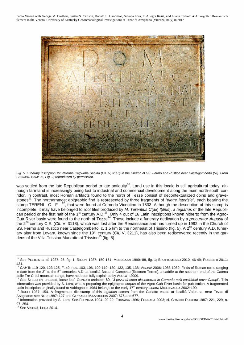
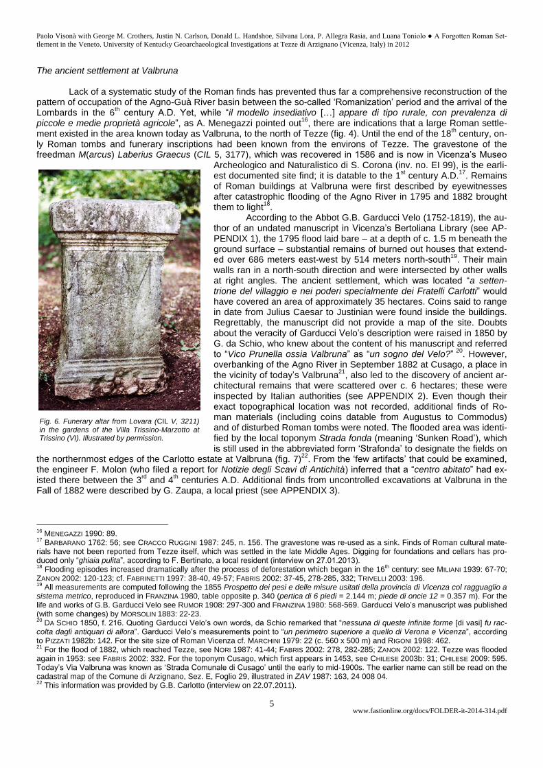
Fig. 5. Funerary inscription for Vaternia Calpurnia Sabina (CIL V, 3118) in the Church of SS. Fermo and Rustico near Castelgomberto (VI). From FORNASA 1994: 36, Fig. 2; reproduced by permission.
was settled from the late Republican period to late antiquity
10. Land use in this locale is still agricultural today, alt-
hough farmland is increasingly being lost to industrial and commercial development along the main north-south cor-ridor. In contrast, most Roman artifacts found to the north of Tezze consist of decontextualized coins and grave-stones
11. The northernmost epigraphic find is represented by three fragments of “pietre laterizie”, each bearing the
stamp TERENI · C · F · 12
, that were found at Cornedo Vicentino in 1833. Although the description of this stamp is incomplete, it may have belonged to roof tiles produced by M. Terentius C(aii) f(ilius), a teglarius of the late Republi-can period or the first half of the 1
st century A.D.
13. Only 4 out of 16 Latin inscriptions known hitherto from the Agno-
Guà River basin were found to the north of Tezze14
. These include a funerary dedication by a procurator Augusti of the 2
nd century C.E. (CIL V, 3118), which was lost after the Renaissance and has turned up in 1992 in the Church of
SS. Fermo and Rustico near Castelgomberto, c. 1.5 km to the northeast of Trissino (fig. 5). A 2nd
century A.D. funer-ary altar from Lovara, known since the 19
th century (CIL V, 3211), has also been rediscovered recently in the gar-
dens of the Villa Trissino-Marzotto at Trissino15
(fig. 6).
10
See PELTRIN et al. 1987: 25, fig. 1; RIGONI 1987: 150-151; MENEGAZZI 1990: 88, fig. 1; BRUTTOMESSO 2010: 46-49; POSSENTI 2011: 431. 11
CAV II: 119-120, 123-125, F. 49, nos. 103, 106, 109-110, 130, 132, 135, 138; VISONÀ 2006: 1088-1089. Finds of Roman coins ranging in date from the 3
rd to the 5
th centuries A.D. at località Basto al Campetto (Recoaro Terme), a saddle at the southern end of the Catena
delle Tre Croci mountain range, have not been fully explained by ASOLATI 2009. 12
See STECCHINI undated, loose leaf; GONZATI undated: 89, “3 pezzi di cotto dissotterrati in Cornedo nelli cosiddetti nove Campi”. This information was provided by S. Lora, who is preparing the epigraphic corpus of the Agno-Guà River basin for publication. A fragmented Latin inscription originally found at Valdagno in 1964 belongs to the early 17
th century, contra MIGLIAVACCA 2002: 199.
13 BUCHI 1987: 154. A fragmented tile stamp of this teglarius comes from the Carlotto estate at località Valbruna, near Tezze di
Arzignano: see NORI 1987: 127 and CIPRIANO, MAZZOCCHIN 2007: 675 and 677. 14
Information provided by S. Lora. See FORNASA 1994: 20-29; FORNASA 1996; FORNASA 2003; cf. CRACCO RUGGINI 1987: 221, 229, n. 97, 254. 15
See VISONÀ, LORA 2014.
Paolo Visonà with George M. Crothers, Justin N. Carlson, Donald L. Handshoe, Silvana Lora, P. Allegra Rasia, and Luana Toniolo ● A Forgotten Roman Set-
tlement in the Veneto. University of Kentucky Geoarchaeological Investigations at Tezze di Arzignano (Vicenza, Italy) in 2012
www.fastionline.org/docs/FOLDER-it-2014-314.pdf 5
The ancient settlement at Valbruna
Lack of a systematic study of the Roman finds has prevented thus far a comprehensive reconstruction of the pattern of occupation of the Agno-Guà River basin between the so-called ‘Romanization’ period and the arrival of the Lombards in the 6
th century A.D. Yet, while “il modello insediativo […] appare di tipo rurale, con prevalenza di
piccole e medie proprietà agricole”, as A. Menegazzi pointed out16
, there are indications that a large Roman settle-ment existed in the area known today as Valbruna, to the north of Tezze (fig. 4). Until the end of the 18
th century, on-
ly Roman tombs and funerary inscriptions had been known from the environs of Tezze. The gravestone of the freedman M(arcus) Laberius Graecus (CIL 5, 3177), which was recovered in 1586 and is now in Vicenza’s Museo
Archeologico and Naturalistico di S. Corona (inv. no. EI 99), is the earli-est documented site find; it is datable to the 1
st century A.D.
17. Remains
of Roman buildings at Valbruna were first described by eyewitnesses after catastrophic flooding of the Agno River in 1795 and 1882 brought them to light
18.
According to the Abbot G.B. Garducci Velo (1752-1819), the au-thor of an undated manuscript in Vicenza’s Bertoliana Library (see AP-PENDIX 1), the 1795 flood laid bare – at a depth of c. 1.5 m beneath the ground surface – substantial remains of burned out houses that extend-ed over 686 meters east-west by 514 meters north-south
19. Their main
walls ran in a north-south direction and were intersected by other walls at right angles. The ancient settlement, which was located “a setten-trione del villaggio e nei poderi specialmente dei Fratelli Carlotti” would have covered an area of approximately 35 hectares. Coins said to range in date from Julius Caesar to Justinian were found inside the buildings. Regrettably, the manuscript did not provide a map of the site. Doubts about the veracity of Garducci Velo’s description were raised in 1850 by G. da Schio, who knew about the content of his manuscript and referred to “Vico Prunella ossia Valbruna” as “un sogno del Velo?”
20. However,
overbanking of the Agno River in September 1882 at Cusago, a place in the vicinity of today’s Valbruna
21, also led to the discovery of ancient ar-
chitectural remains that were scattered over c. 6 hectares; these were inspected by Italian authorities (see APPENDIX 2). Even though their exact topographical location was not recorded, additional finds of Ro-man materials (including coins datable from Augustus to Commodus) and of disturbed Roman tombs were noted. The flooded area was identi-fied by the local toponym Strada fonda (meaning ‘Sunken Road’), which is still used in the abbreviated form ‘Strafonda’ to designate the fields on
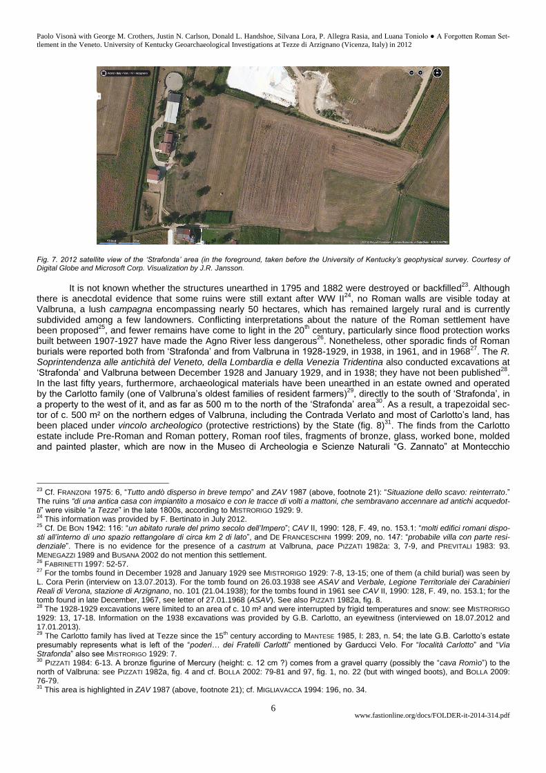
the northernmost edges of the Carlotto estate at Valbruna (fig. 7)22
. From the ‘few artifacts’ that could be examined, the engineer F. Molon (who filed a report for Notizie degli Scavi di Antichità) inferred that a “centro abitato” had ex-isted there between the 3
rd and 4
th centuries A.D. Additional finds from uncontrolled excavations at Valbruna in the
Fall of 1882 were described by G. Zaupa, a local priest (see APPENDIX 3).
16
MENEGAZZI 1990: 89. 17
BARBARANO 1762: 56; see CRACCO RUGGINI 1987: 245, n. 156. The gravestone was re-used as a sink. Finds of Roman cultural mate-rials have not been reported from Tezze itself, which was settled in the late Middle Ages. Digging for foundations and cellars has pro-duced only “ghiaia pulita”, according to F. Bertinato, a local resident (interview on 27.01.2013). 18
Flooding episodes increased dramatically after the process of deforestation which began in the 16th century: see MILIANI 1939: 67-70;
ZANON 2002: 120-123; cf. FABRINETTI 1997: 38-40, 49-57; FABRIS 2002: 37-45, 278-285, 332; TRIVELLI 2003: 196. 19
All measurements are computed following the 1855 Prospetto dei pesi e delle misure usitati della provincia di Vicenza col ragguaglio a sistema metrico, reproduced in FRANZINA 1980, table opposite p. 340 (pertica di 6 piedi = 2.144 m; piede di oncie 12 = 0.357 m). For the life and works of G.B. Garducci Velo see RUMOR 1908: 297-300 and FRANZINA 1980: 568-569. Garducci Velo’s manuscript was published (with some changes) by MORSOLIN 1883: 22-23. 20
DA SCHIO 1850, f. 216. Quoting Garducci Velo’s own words, da Schio remarked that “nessuna di queste infinite forme [di vasi] fu rac-colta dagli antiquari di allora”. Garducci Velo’s measurements point to “un perimetro superiore a quello di Verona e Vicenza”, according to PIZZATI 1982b: 142. For the site size of Roman Vicenza cf. MARCHINI 1979: 22 (c. 560 x 500 m) and RIGONI 1998: 462. 21
For the flood of 1882, which reached Tezze, see NORI 1987: 41-44; FABRIS 2002: 278, 282-285; ZANON 2002: 122. Tezze was flooded again in 1953: see FABRIS 2002: 332. For the toponym Cusago, which first appears in 1453, see CHILESE 2003b: 31; CHILESE 2009: 595. Today’s Via Valbruna was known as ‘Strada Comunale di Cusago’ until the early to mid-1900s. The earlier name can still be read on the cadastral map of the Comune di Arzignano, Sez. E, Foglio 29, illustrated in ZAV 1987: 163, 24 008 04. 22
This information was provided by G.B. Carlotto (interview on 22.07.2011).
Fig. 6. Funerary altar from Lovara (CIL V, 3211) in the gardens of the Villa Trissino-Marzotto at Trissino (VI). Illustrated by permission.
Paolo Visonà with George M. Crothers, Justin N. Carlson, Donald L. Handshoe, Silvana Lora, P. Allegra Rasia, and Luana Toniolo ● A Forgotten Roman Set-
tlement in the Veneto. University of Kentucky Geoarchaeological Investigations at Tezze di Arzignano (Vicenza, Italy) in 2012
www.fastionline.org/docs/FOLDER-it-2014-314.pdf 6
Fig. 7. 2012 satellite view of the ‘Strafonda’ area (in the foreground, taken before the University of Kentucky’s geophysical survey. Courtesy of Digital Globe and Microsoft Corp. Visualization by J.R. Jansson.
It is not known whether the structures unearthed in 1795 and 1882 were destroyed or backfilled
23. Although
there is anecdotal evidence that some ruins were still extant after WW II24
, no Roman walls are visible today at Valbruna, a lush campagna encompassing nearly 50 hectares, which has remained largely rural and is currently subdivided among a few landowners. Conflicting interpretations about the nature of the Roman settlement have been proposed
25, and fewer remains have come to light in the 20
th century, particularly since flood protection works
built between 1907-1927 have made the Agno River less dangerous26
. Nonetheless, other sporadic finds of Roman burials were reported both from ‘Strafonda’ and from Valbruna in 1928-1929, in 1938, in 1961, and in 1968
27. The R.
Soprintendenza alle antichità del Veneto, della Lombardia e della Venezia Tridentina also conducted excavations at ‘Strafonda’ and Valbruna between December 1928 and January 1929, and in 1938; they have not been published
28.
In the last fifty years, furthermore, archaeological materials have been unearthed in an estate owned and operated by the Carlotto family (one of Valbruna’s oldest families of resident farmers)
29, directly to the south of ‘Strafonda’, in
a property to the west of it, and as far as 500 m to the north of the ‘Strafonda’ area30
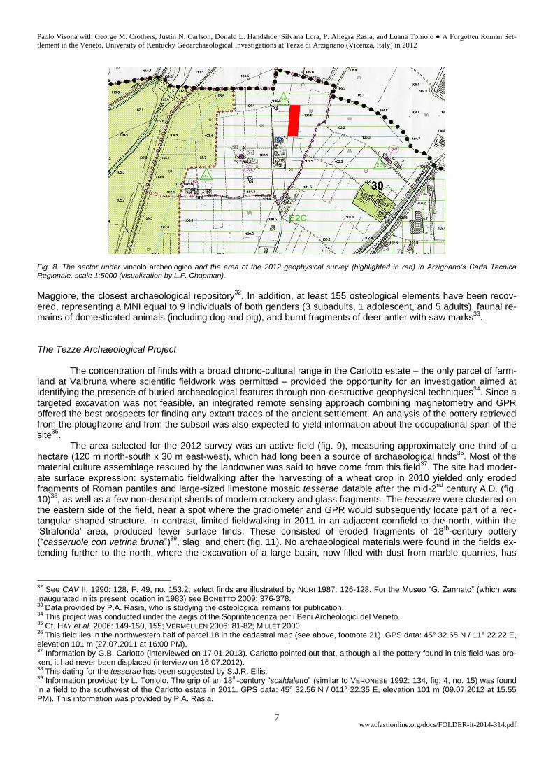
. As a result, a trapezoidal sec-tor of c. 500 m² on the northern edges of Valbruna, including the Contrada Verlato and most of Carlotto’s land, has been placed under vincolo archeologico (protective restrictions) by the State (fig. 8)
31. The finds from the Carlotto
estate include Pre-Roman and Roman pottery, Roman roof tiles, fragments of bronze, glass, worked bone, molded and painted plaster, which are now in the Museo di Archeologia e Scienze Naturali “G. Zannato” at Montecchio
23
Cf. FRANZONI 1975: 6, “Tutto andò disperso in breve tempo” and ZAV 1987 (above, footnote 21): “Situazione dello scavo: reinterrato.” The ruins “di una antica casa con impiantito a mosaico e con le tracce di volti a mattoni, che sembravano accennare ad antichi acquedot-ti” were visible “a Tezze” in the late 1800s, according to MISTRORIGO 1929: 9. 24
This information was provided by F. Bertinato in July 2012. 25
Cf. DE BON 1942: 116: “un abitato rurale del primo secolo dell’Impero”; CAV II, 1990: 128, F. 49, no. 153.1: “molti edifici romani dispo-sti all’interno di uno spazio rettangolare di circa km 2 di lato”, and DE FRANCESCHINI 1999: 209, no. 147: “probabile villa con parte resi-denziale”. There is no evidence for the presence of a castrum at Valbruna, pace PIZZATI 1982a: 3, 7-9, and PREVITALI 1983: 93. MENEGAZZI 1989 and BUSANA 2002 do not mention this settlement. 26
FABRINETTI 1997: 52-57. 27
For the tombs found in December 1928 and January 1929 see MISTRORIGO 1929: 7-8, 13-15; one of them (a child burial) was seen by L. Cora Perin (interview on 13.07.2013). For the tomb found on 26.03.1938 see ASAV and Verbale, Legione Territoriale dei Carabinieri Reali di Verona, stazione di Arzignano, no. 101 (21.04.1938); for the tombs found in 1961 see CAV II, 1990: 128, F. 49, no. 153.1; for the tomb found in late December, 1967, see letter of 27.01.1968 (ASAV). See also PIZZATI 1982a, fig. 8. 28
The 1928-1929 excavations were limited to an area of c. 10 m² and were interrupted by frigid temperatures and snow: see MISTRORIGO 1929: 13, 17-18. Information on the 1938 excavations was provided by G.B. Carlotto, an eyewitness (interviewed on 18.07.2012 and 17.01.2013). 29
The Carlotto family has lived at Tezze since the 15th century according to MANTESE 1985, I: 283, n. 54; the late G.B. Carlotto’s estate
presumably represents what is left of the “poderi… dei Fratelli Carlotti” mentioned by Garducci Velo. For “località Carlotto” and “Via Strafonda” also see MISTRORIGO 1929: 7. 30
PIZZATI 1984: 6-13. A bronze figurine of Mercury (height: c. 12 cm ?) comes from a gravel quarry (possibly the “cava Romìo”) to the north of Valbruna: see PIZZATI 1982a, fig. 4 and cf. BOLLA 2002: 79-81 and 97, fig. 1, no. 22 (but with winged boots), and BOLLA 2009: 76-79. 31
This area is highlighted in ZAV 1987 (above, footnote 21); cf. MIGLIAVACCA 1994: 196, no. 34.
Paolo Visonà with George M. Crothers, Justin N. Carlson, Donald L. Handshoe, Silvana Lora, P. Allegra Rasia, and Luana Toniolo ● A Forgotten Roman Set-
tlement in the Veneto. University of Kentucky Geoarchaeological Investigations at Tezze di Arzignano (Vicenza, Italy) in 2012
www.fastionline.org/docs/FOLDER-it-2014-314.pdf 7
Fig. 8. The sector under vincolo archeologico and the area of the 2012 geophysical survey (highlighted in red) in Arzignano’s Carta Tecnica Regionale, scale 1:5000 (visualization by L.F. Chapman).
Maggiore, the closest archaeological repository
32. In addition, at least 155 osteological elements have been recov-
ered, representing a MNI equal to 9 individuals of both genders (3 subadults, 1 adolescent, and 5 adults), faunal re-mains of domesticated animals (including dog and pig), and burnt fragments of deer antler with saw marks
33.
The Tezze Archaeological Project
The concentration of finds with a broad chrono-cultural range in the Carlotto estate – the only parcel of farm-land at Valbruna where scientific fieldwork was permitted – provided the opportunity for an investigation aimed at identifying the presence of buried archaeological features through non-destructive geophysical techniques
34. Since a
targeted excavation was not feasible, an integrated remote sensing approach combining magnetometry and GPR offered the best prospects for finding any extant traces of the ancient settlement. An analysis of the pottery retrieved from the ploughzone and from the subsoil was also expected to yield information about the occupational span of the site
35.
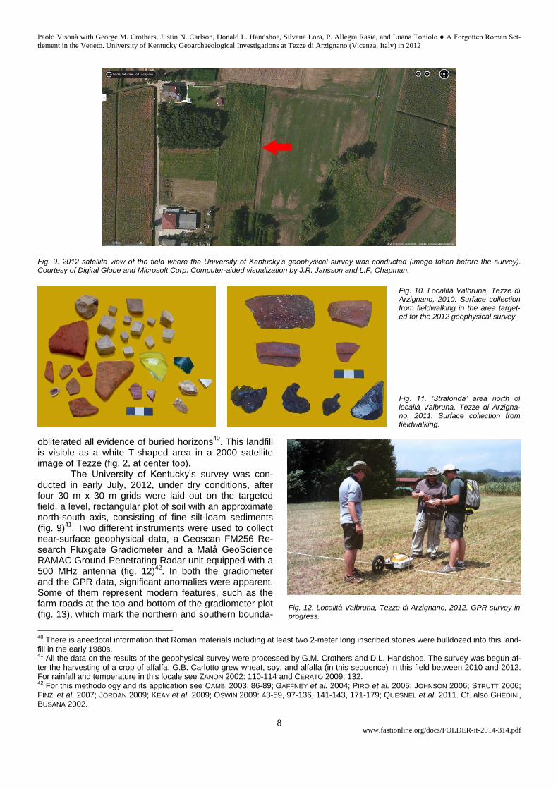
The area selected for the 2012 survey was an active field (fig. 9), measuring approximately one third of a hectare (120 m north-south x 30 m east-west), which had long been a source of archaeological finds
36. Most of the
material culture assemblage rescued by the landowner was said to have come from this field37
. The site had moder-ate surface expression: systematic fieldwalking after the harvesting of a wheat crop in 2010 yielded only eroded fragments of Roman pantiles and large-sized limestone mosaic tesserae datable after the mid-2
nd century A.D. (fig.
10)38
, as well as a few non-descript sherds of modern crockery and glass fragments. The tesserae were clustered on the eastern side of the field, near a spot where the gradiometer and GPR would subsequently locate part of a rec-tangular shaped structure. In contrast, limited fieldwalking in 2011 in an adjacent cornfield to the north, within the ‘Strafonda’ area, produced fewer surface finds. These consisted of eroded fragments of 18
th-century pottery
(“casseruole con vetrina bruna”)39
, slag, and chert (fig. 11). No archaeological materials were found in the fields ex-tending further to the north, where the excavation of a large basin, now filled with dust from marble quarries, has
32
See CAV II, 1990: 128, F. 49, no. 153.2; select finds are illustrated by NORI 1987: 126-128. For the Museo “G. Zannato” (which was inaugurated in its present location in 1983) see BONETTO 2009: 376-378. 33
Data provided by P.A. Rasia, who is studying the osteological remains for publication. 34
This project was conducted under the aegis of the Soprintendenza per i Beni Archeologici del Veneto. 35
Cf. HAY et al. 2006: 149-150, 155; VERMEULEN 2006: 81-82; MILLET 2000. 36
This field lies in the northwestern half of parcel 18 in the cadastral map (see above, footnote 21). GPS data: 45° 32.65 N / 11° 22.22 E, elevation 101 m (27.07.2011 at 16:00 PM). 37
Information by G.B. Carlotto (interviewed on 17.01.2013). Carlotto pointed out that, although all the pottery found in this field was bro-ken, it had never been displaced (interview on 16.07.2012). 38
This dating for the tesserae has been suggested by S.J.R. Ellis. 39
Information provided by L. Toniolo. The grip of an 18th-century “scaldaletto” (similar to VERONESE 1992: 134, fig. 4, no. 15) was found
in a field to the southwest of the Carlotto estate in 2011. GPS data: 45° 32.56 N / 011° 22.35 E, elevation 101 m (09.07.2012 at 15.55 PM). This information was provided by P.A. Rasia.
Paolo Visonà with George M. Crothers, Justin N. Carlson, Donald L. Handshoe, Silvana Lora, P. Allegra Rasia, and Luana Toniolo ● A Forgotten Roman Set-
tlement in the Veneto. University of Kentucky Geoarchaeological Investigations at Tezze di Arzignano (Vicenza, Italy) in 2012
www.fastionline.org/docs/FOLDER-it-2014-314.pdf 8
Fig. 9. 2012 satellite view of the field where the University of Kentucky’s geophysical survey was conducted (image taken before the survey). Courtesy of Digital Globe and Microsoft Corp. Computer-aided visualization by J.R. Jansson and L.F. Chapman.
obliterated all evidence of buried horizons40
. This landfill is visible as a white T-shaped area in a 2000 satellite image of Tezze (fig. 2, at center top).
The University of Kentucky’s survey was con-ducted in early July, 2012, under dry conditions, after four 30 m x 30 m grids were laid out on the targeted field, a level, rectangular plot of soil with an approximate north-south axis, consisting of fine silt-loam sediments (fig. 9)
41. Two different instruments were used to collect
near-surface geophysical data, a Geoscan FM256 Re-search Fluxgate Gradiometer and a Malå GeoScience RAMAC Ground Penetrating Radar unit equipped with a 500 MHz antenna (fig. 12)
42. In both the gradiometer
and the GPR data, significant anomalies were apparent. Some of them represent modern features, such as the farm roads at the top and bottom of the gradiometer plot (fig. 13), which mark the northern and southern bounda-
40
There is anecdotal information that Roman materials including at least two 2-meter long inscribed stones were bulldozed into this land-fill in the early 1980s. 41
All the data on the results of the geophysical survey were processed by G.M. Crothers and D.L. Handshoe. The survey was begun af-ter the harvesting of a crop of alfalfa. G.B. Carlotto grew wheat, soy, and alfalfa (in this sequence) in this field between 2010 and 2012. For rainfall and temperature in this locale see ZANON 2002: 110-114 and CERATO 2009: 132. 42
For this methodology and its application see CAMBI 2003: 86-89; GAFFNEY et al. 2004; PIRO et al. 2005; JOHNSON 2006; STRUTT 2006; FINZI et al. 2007; JORDAN 2009; KEAY et al. 2009; OSWIN 2009: 43-59, 97-136, 141-143, 171-179; QUESNEL et al. 2011. Cf. also GHEDINI, BUSANA 2002.
Fig. 10. Località Valbruna, Tezze di Arzignano, 2010. Surface collection from fieldwalking in the area target-ed for the 2012 geophysical survey.
Fig. 11. ‘Strafonda’ area north of localià Valbruna, Tezze di Arzigna-no, 2011. Surface collection from fieldwalking.
Fig. 12. Località Valbruna, Tezze di Arzignano, 2012. GPR survey in progress.
Paolo Visonà with George M. Crothers, Justin N. Carlson, Donald L. Handshoe, Silvana Lora, P. Allegra Rasia, and Luana Toniolo ● A Forgotten Roman Set-
tlement in the Veneto. University of Kentucky Geoarchaeological Investigations at Tezze di Arzignano (Vicenza, Italy) in 2012
www.fastionline.org/docs/FOLDER-it-2014-314.pdf 9
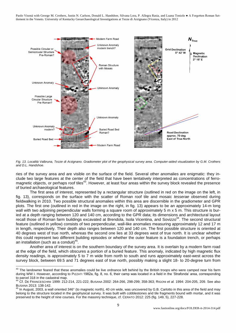
Fig. 13. Località Valbruna, Tezze di Arzignano. Gradiometer plot of the geophysical survey area. Computer-aided visualization by G.M. Crothers and D.L. Handshoe.
ries of the survey area and are visible on the surface of the field. Several other anomalies are enigmatic: they in-clude two large features at the center of the field that have been tentatively interpreted as concentrations of ferro-magnetic objects, or perhaps roof tiles
43. However, at least four areas within the survey block revealed the presence
of buried archaeological features. The first area of interest, represented by a rectangular structure (outlined in red on the image on the left, in
fig. 13), corresponds on the surface with the scatter of Roman roof tile and mosaic tesserae observed during fieldwalking in 2010. Two possible structural anomalies within this area are discernible in the gradiometer and GPR plots. The first one (outlined in red in the image on the right, in fig. 13) appears to be an approximately 14-m long wall with two adjoining perpendicular walls forming a square room of approximately 5 m x 5 m. This structure is bur-ied at a depth ranging between 120 and 140 cm, according to the GPR data; its dimensions and architectural layout recall those of Roman farm buildings excavated at Brendola, Isola Vicentina, and Sovizzo
44. The second structural
feature (outlined in yellow) consists of two perpendicular, wall-like anomalies measuring approximately 12 and 17 m in length, respectively. Their depth also ranges between 120 and 140 cm. The first possible structure is oriented at 40 degrees west of true north, whereas the second one lies at 33 degrees west of true north. It is unclear whether this could represent two different building episodes or whether the outer feature is a foundation trench, or perhaps an installation (such as a conduit)
45.
Another area of interest is on the southern boundary of the survey area. It is overlain by a modern farm road at the edge of the field, which obscures a portion of a buried feature. This anomaly, indicated by high magnetic flux density readings, is approximately 5 to 7 m wide from north to south and runs approximately east-west across the survey block, between 69.5 and 71 degrees east of true north, possibly making a slight 18- to 20-degree turn from
43
The landowner feared that these anomalies could be live ordnance left behind by the British troops who were camped near his farm during WW I. However, according to PIZZATI 1982a, fig. 8, no. 6, their camp was located in a field in the ‘Strafonda’ area, corresponding to parcel 318 in the cadastral map. 44
Cf. DE FRANCESCHINI 1999: 212-214, 221-222; BUSANA 2002: 264-266, 298-299; 358-363; RIGONI et al. 1994: 204-205, 209. See also BUSANA 2013: 138-142. 45
In August, 2003, a wall oriented 346° (to magnetic north), 40 cm wide, was uncovered by G.B. Carlotto in this area of the field and may belong to the structure located in the geophysical survey. It was built with cobblestones and tile fragments bound with mortar, and it was preserved to the height of nine courses. For the masonry technique, cf. CERATO 2012: 225 (fig. 149, 5), 227-228.
Paolo Visonà with George M. Crothers, Justin N. Carlson, Donald L. Handshoe, Silvana Lora, P. Allegra Rasia, and Luana Toniolo ● A Forgotten Roman Set-
tlement in the Veneto. University of Kentucky Geoarchaeological Investigations at Tezze di Arzignano (Vicenza, Italy) in 2012
www.fastionline.org/docs/FOLDER-it-2014-314.pdf 10
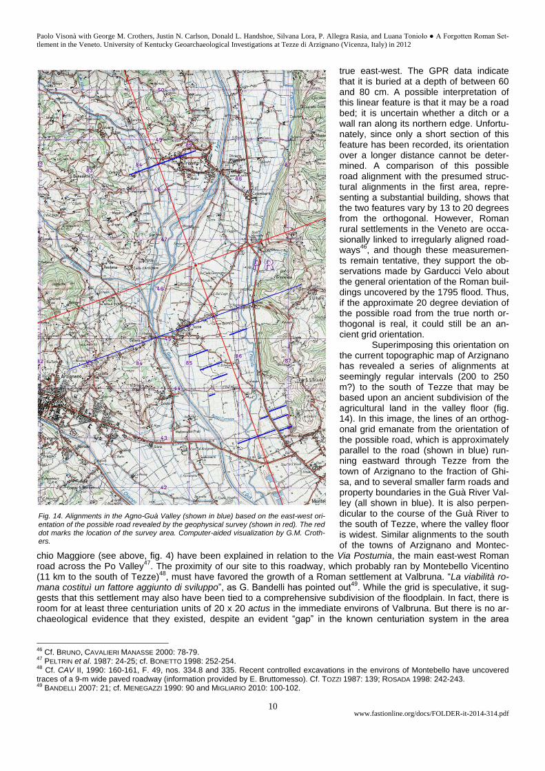
true east-west. The GPR data indicate that it is buried at a depth of between 60 and 80 cm. A possible interpretation of this linear feature is that it may be a road bed; it is uncertain whether a ditch or a wall ran along its northern edge. Unfortu-nately, since only a short section of this feature has been recorded, its orientation over a longer distance cannot be deter-mined. A comparison of this possible road alignment with the presumed struc-tural alignments in the first area, repre-senting a substantial building, shows that the two features vary by 13 to 20 degrees from the orthogonal. However, Roman rural settlements in the Veneto are occa-sionally linked to irregularly aligned road-ways
46, and though these measuremen-
ts remain tentative, they support the ob-servations made by Garducci Velo about the general orientation of the Roman buil-dings uncovered by the 1795 flood. Thus, if the approximate 20 degree deviation of the possible road from the true north or-thogonal is real, it could still be an an-cient grid orientation.
Superimposing this orientation on the current topographic map of Arzignano has revealed a series of alignments at seemingly regular intervals (200 to 250 m?) to the south of Tezze that may be based upon an ancient subdivision of the agricultural land in the valley floor (fig. 14). In this image, the lines of an orthog-onal grid emanate from the orientation of the possible road, which is approximately parallel to the road (shown in blue) run-ning eastward through Tezze from the town of Arzignano to the fraction of Ghi-sa, and to several smaller farm roads and property boundaries in the Guà River Val-ley (all shown in blue). It is also perpen-dicular to the course of the Guà River to the south of Tezze, where the valley floor is widest. Similar alignments to the south of the towns of Arzignano and Montec-
chio Maggiore (see above, fig. 4) have been explained in relation to the Via Postumia, the main east-west Roman road across the Po Valley
47. The proximity of our site to this roadway, which probably ran by Montebello Vicentino
(11 km to the south of Tezze)48
, must have favored the growth of a Roman settlement at Valbruna. “La viabilità ro-mana costituì un fattore aggiunto di sviluppo”, as G. Bandelli has pointed out
49. While the grid is speculative, it sug-
gests that this settlement may also have been tied to a comprehensive subdivision of the floodplain. In fact, there is room for at least three centuriation units of 20 x 20 actus in the immediate environs of Valbruna. But there is no ar-chaeological evidence that they existed, despite an evident “gap” in the known centuriation system in the area
46
Cf. BRUNO, CAVALIERI MANASSE 2000: 78-79. 47
PELTRIN et al. 1987: 24-25; cf. BONETTO 1998: 252-254. 48
Cf. CAV II, 1990: 160-161, F. 49, nos. 334.8 and 335. Recent controlled excavations in the environs of Montebello have uncovered traces of a 9-m wide paved roadway (information provided by E. Bruttomesso). Cf. TOZZI 1987: 139; ROSADA 1998: 242-243. 49
BANDELLI 2007: 21; cf. MENEGAZZI 1990: 90 and MIGLIARIO 2010: 100-102.
Fig. 14. Alignments in the Agno-Guà Valley (shown in blue) based on the east-west ori-entation of the possible road revealed by the geophysical survey (shown in red). The red dot marks the location of the survey area. Computer-aided visualization by G.M. Croth-ers.
Paolo Visonà with George M. Crothers, Justin N. Carlson, Donald L. Handshoe, Silvana Lora, P. Allegra Rasia, and Luana Toniolo ● A Forgotten Roman Set-
tlement in the Veneto. University of Kentucky Geoarchaeological Investigations at Tezze di Arzignano (Vicenza, Italy) in 2012
www.fastionline.org/docs/FOLDER-it-2014-314.pdf 11
between the Valle d’Illasi (to the east of Verona) and the ager of Vicetia
50. Local scholars already noted that “le tracce abita-
tive affiorate a livello di campagna nell’ampio territorio com-preso fra Arzignano e Montecchio Maggiore risultano inserite nelle aree nelle quali persiste il regolare allineamento dei campi. Viceversa, le aree che non manifestano tale caratteri-stica (la zona a nord-ovest di S. Vitale, la destra idrografica dell’Agno-Guà tra Montorso e Montebello, il bacino del Bren-dola, ecc.) dovrebbero costituire le parti di territorio rurale che più frequentemente, nel corso dei secoli successivi alla cadu-ta dell’impero romano, sono state sconvolte dalle esondazio-ni dei corsi d’acqua”
51. Traces of an ancient parcelization of
the rural landscape are less likely to have been preserved to the north of Tezze because of the greater erosion and deep-er fluvial deposits caused by the action of three overbanking streams.
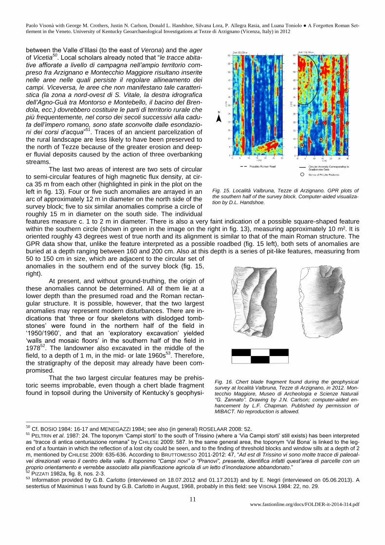
The last two areas of interest are two sets of circular to semi-circular features of high magnetic flux density, at cir-ca 35 m from each other (highlighted in pink in the plot on the left in fig. 13). Four or five such anomalies are arrayed in an arc of approximately 12 m in diameter on the north side of the survey block; five to six similar anomalies comprise a circle of roughly 15 m in diameter on the south side. The individual features measure c. 1 to 2 m in diameter. There is also a very faint indication of a possible square-shaped feature within the southern circle (shown in green in the image on the right in fig. 13), measuring approximately 10 m². It is oriented roughly 43 degrees west of true north and its alignment is similar to that of the main Roman structure. The GPR data show that, unlike the feature interpreted as a possible roadbed (fig. 15 left), both sets of anomalies are buried at a depth ranging between 160 and 200 cm. Also at this depth is a series of pit-like features, measuring from 50 to 150 cm in size, which are adjacent to the circular set of anomalies in the southern end of the survey block (fig. 15, right).
At present, and without ground-truthing, the origin of these anomalies cannot be determined. All of them lie at a lower depth than the presumed road and the Roman rectan-gular structure. It is possible, however, that the two largest anomalies may represent modern disturbances. There are in-dications that ‘three or four skeletons with dislodged tomb-stones’ were found in the northern half of the field in ‘1950/1960’, and that an ‘exploratory excavation’ yielded ‘walls and mosaic floors’ in the southern half of the field in 1978
52. The landowner also excavated in the middle of the
field, to a depth of 1 m, in the mid- or late 1960s53
. Therefore, the stratigraphy of the deposit may already have been com-promised.
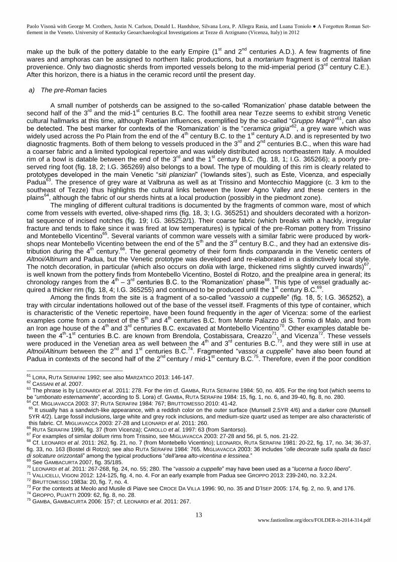
That the two largest circular features may be prehis-toric seems improbable, even though a chert blade fragment found in topsoil during the University of Kentucky’s geophysi-
50 Cf. BOSIO 1984: 16-17 and MENEGAZZI 1984; see also (in general) ROSELAAR 2008: 52. 51
PELTRIN et al. 1987: 24. The toponym ‘Campi storti’ to the south of Trissino (where a ‘Via Campi storti’ still exists) has been interpreted as “tracce di antica centuriazione romana” by CHILESE 2009: 587. In the same general area, the toponym ‘Val Bona’ is linked to the leg-end of a fountain in which the reflection of a lost city could be seen, and to the finding of threshold blocks and window sills at a depth of 2 m, mentioned by CHILESE 2009: 635-636. According to BRUTTOMESSO 2011-2012: 47, “Ad est di Trissino vi sono molte tracce di paleoal-vei direzionati verso il centro della valle. Il toponimo “Campi novi” o “Pranovi”, presente, identifica infatti quest’area di parcelle con un proprio orientamento e verrebbe associato alla pianificazione agricola di un letto d’inondazione abbandonato.” 52
PIZZATI 1982a, fig. 8, nos. 2-3. 53
Information provided by G.B. Carlotto (interviewed on 18.07.2012 and 01.17.2013) and by E. Negri (interviewed on 05.06.2013). A sestertius of Maximinus I was found by G.B. Carlotto in August, 1968, probably in this field: see VISONÀ 1984: 22, no. 29.
Fig. 15. Località Valbruna, Tezze di Arzignano. GPR plots of the southern half of the survey block. Computer-aided visualiza-tion by D.L. Handshoe.
Fig. 16. Chert blade fragment found during the geophysical survey at località Valbruna, Tezze di Arzignano, in 2012. Mon-tecchio Maggiore, Museo di Archeologia e Scienze Naturali “G. Zannato”. Drawing by J.N. Carlson; computer-aided en-hancement by L.F. Chapman. Published by permission of MIBACT. No reproduction is allowed.

Paolo Visonà with George M. Crothers, Justin N. Carlson, Donald L. Handshoe, Silvana Lora, P. Allegra Rasia, and Luana Toniolo ● A Forgotten Roman Set-
tlement in the Veneto. University of Kentucky Geoarchaeological Investigations at Tezze di Arzignano (Vicenza, Italy) in 2012
www.fastionline.org/docs/FOLDER-it-2014-314.pdf 12
cal survey suggests that this area was frequented in the late Neolithic or the early Bronze age (fig. 16)54
. Much smaller sub-circular features, interpreted as the remains of Neolithic shelters, are known from settlements of the Fiorano Culture excavated at Savignano near Modena and at Le Basse di Valcalaona in the southern Veneto, and from Colognola ai Colli, to the east of Verona
55. Traces of “unità abitative del tipo probabilmente capannicolo a
pianta ellisoidale seminterrata”, datable to the second half of the 10th and to the 9
th centuries B.C., and circular struc-
tures (diameter: 2.4 to 2.8 m), datable between the 5th and 2
nd centuries B.C., have also been found at Montebello
Vicentino and S. Ambrogio di Valpolicella56
. Nonetheless, a series of regular pits slightly over 1 m in diameter, inter-preted as bins for the storage of foodstuffs, and as refuse pits, was found outside the presumed Neolithic dwellings at Savignano, and there is evidence that circular pits of various sizes were used for different functions at several sites in the Veneto from the Neolithic to the early Iron age
57. These comparanda, and the presence of a few frag-
ments of pre-Roman pottery among the finds from the Carlotto estate, do not preclude the possibility that the pit-like features detected by the GPR may have cultural significance. Unfortunately, we were not allowed to conduct any testing or coring to determine the nature of these anomalies, and we could not expand our survey into the adjacent fields to provide greater horizontal coverage
58.
G.M.C., J.N.C., D.L.H., S.L., P.A.R., P.V.
The pottery from the Carlotto estate at Valbruna
The decontextualized sherds found in the Carlotto estate range in date from the 4
th-
3rd
centuries B.C. to the modern age and comprise the only sample of pottery currently available from Valbruna. They originated for the most part from the same field where the geophysical survey was conducted
59. Their
relatively sharp breaks also suggest that they were not rolled around and eroded by allu-viation. Body sherds (53.65%) and coarse ware handles (17.14%) make up most of the ceramic finds; there are relatively few rims and bases (29.21%). The interpretation of this material is hampered not only by its poor condition, but also by the dearth of published comparanda from this corner of the Veneto. Examples of imported fine wares and of
transport amphoras that could yield reliable chronological markers are exceedingly scarce. Nevertheless, compari-sons with pottery finds from nearby sites in the ager of Vicenza, and from Padua, Verona, and the Venice area, have proved useful to identify the coarse wares made locally, which comprise 61.75% of this assemblage
60.
Three horizons stand out (fig. 17). The pre-Roman facies is documented by relatively few sherds datable to the final phases of the Late Iron age and to the ‘Romanization’ period. Locally-produced coarse and cooking wares
54
GPS data: 45°32.61 N / 11° 22.36 E, elevation 100 m (11.07.2012 at 14.55 PM). Length: 3.4 cm; width: 2.1 cm (proximal) x 1.8 cm (distal); thickness: 0.5 cm. Munsell: between 10YR 6/2 (pale yellowish brown) and 5YR N6 (light gray). Data provided by J.N. Carlson. Cf. CHELIDONIO, MOTTES 1994: 81, fig. 1, no. 2. 55
BAGOLINI 1987: 73-74; SALZANI 1992: 101-102. 56
DE GUIO 1987: 100; BROMBO 2012: 161-162. 57
Cf. BAGOLINI 1987: 73 (Savignano); SALZANI 1989: 144-146 (Gazzo Veronese); SALZANI, CHELIDONIO 1995: 53-55 (Nogara); BIANCHIN
CITTON 1996: 100-101 (Roncade); TINÉ et al. 2012: 102-103 (Vicenza, Dal Molin); SALZANI 1987: 112-113 (Mozzecane); BIANCHIN CIT-
TON 1989: 231-234, 252-253 (S. Martino di Lupari – Castello di Godego); GAMBACURTA 2011: 124-125 (Oderzo). 58
Threats of physical violence against the American team by anonymous local residents, reported by G.B. Carlotto, caused the abrupt termination of the University of Kentucky’s geophysical survey after three days of actual fieldwork. There is anecdotal information that other ancient structures were located in the field outside the northeastern corner of parcel 18 in the current cadastral map. In 1910, G.B. Carlotto’s father found “i mattoni per fare un camino” in this field, known as “il Campo Rosso” (information provided by G.B. Carlotto, in-terviewed on 22.06.2010). Remains of buried structures to the east of the Carlotto estate were visibile on infrared aerial photos seen by E. Bruttomesso during the preparation of his tesi di laurea (information provided by E. Bruttomesso on 07.06.2013). 59
See above, footnote 37. In June, 2010, G.B. Carlotto asserted that topsoil was brought to his farm ‘long ago’ and that sand was taken out. Topsoil was needed because the soil was very thin ‘in front of his farm’, where there was gravel at a depth of 30 cm. However, in an interview on 01.17.2013, Carlotto stated that soil was never brought into the field where the geophysical survey was conducted. This field lies c. 150 m. to the north of the Carlotto farmhouse. 60
For the use of this term here, see the remarks by MILLET 2000: 218-219.
Fig. 17. MNI-based quantification of the pottery from the Carlotto estate at località Valbruna, Tezze di Arzignano. Diagram by L. Toniolo.
Paolo Visonà with George M. Crothers, Justin N. Carlson, Donald L. Handshoe, Silvana Lora, P. Allegra Rasia, and Luana Toniolo ● A Forgotten Roman Set-
tlement in the Veneto. University of Kentucky Geoarchaeological Investigations at Tezze di Arzignano (Vicenza, Italy) in 2012
www.fastionline.org/docs/FOLDER-it-2014-314.pdf 13
make up the bulk of the pottery datable to the early Empire (1st and 2
nd centuries A.D.). A few fragments of fine
wares and amphoras can be assigned to northern Italic productions, but a mortarium fragment is of central Italian provenience. Only two diagnostic sherds from imported vessels belong to the mid-imperial period (3
rd century C.E.).
After this horizon, there is a hiatus in the ceramic record until the present day. a) The pre-Roman facies
A small number of potsherds can be assigned to the so-called ‘Romanization’ phase datable between the second half of the 3
rd and the mid-1
st centuries B.C. The foothill area near Tezze seems to exhibit strong Venetic
cultural hallmarks at this time, although Raetian influences, exemplified by the so-called “Gruppo Magrè”61
, can also be detected. The best marker for contexts of the ‘Romanization’ is the “ceramica grigia”
62, a grey ware which was
widely used across the Po Plain from the end of the 4th century B.C. to the 1
st century A.D.
and is represented by two
diagnostic fragments. Both of them belong to vessels produced in the 3rd
and 2nd
centuries B.C., when this ware had a coarser fabric and a limited typological repertoire and was widely distributed across northeastern Italy. A moulded rim of a bowl is datable between the end of the 3
rd and the 1
st century B.C. (fig. 18, 1; I.G. 365266); a poorly pre-
served ring foot (fig. 18, 2; I.G. 365269) also belongs to a bowl. The type of moulding of this rim is clearly related to prototypes developed in the main Venetic “siti planiziari” (‘lowlands sites’), such as Este, Vicenza, and especially Padua
63. The presence of grey ware at Valbruna as well as at Trissino and Montecchio Maggiore (c. 3 km to the
southeast of Tezze) thus highlights the cultural links between the lower Agno Valley and these centers in the plains
64, although the fabric of our sherds hints at a local production (possibly in the piedmont zone). The mingling of different cultural traditions is documented by the fragments of common ware, most of which
come from vessels with everted, olive-shaped rims (fig. 18, 3; I.G. 365251) and shoulders decorated with a horizon-tal sequence of incised notches (fig. 19; I.G. 365252/1). Their coarse fabric (which breaks with a hackly, irregular fracture and tends to flake since it was fired at low temperatures) is typical of the pre-Roman pottery from Trissino and Montebello Vicentino
65. Several variants of common ware vessels with a similar fabric were produced by work-
shops near Montebello Vicentino between the end of the 5th and the 3
rd century B.C., and they had an extensive dis-
tribution during the 4th century.
66. The general geometry of their form finds comparanda in the Venetic centers of
Altnoi/Altinum and Padua, but the Venetic prototype was developed and re-elaborated in a distinctively local style. The notch decoration, in particular (which also occurs on dolia with large, thickened rims slightly curved inwards)
67,
is well known from the pottery finds from Montebello Vicentino, Bostel di Rotzo, and the prealpine area in general; its chronology ranges from the 4
th – 3
rd centuries B.C. to the ‘Romanization’ phase
68. This type of vessel gradually ac-
quired a thicker rim (fig. 18, 4; I.G. 365255) and continued to be produced until the 1st century B.C.
69.
Among the finds from the site is a fragment of a so-called “vassoio a cuppelle” (fig. 18, 5; I.G. 365252), a tray with circular indentations hollowed out of the base of the vessel itself. Fragments of this type of container, which is characteristic of the Venetic repertoire, have been found frequently in the ager of Vicenza: some of the earliest examples come from a context of the 5
th and 4
th centuries B.C. from Monte Palazzo di S. Tomio di Malo, and from
an Iron age house of the 4th and 3
rd centuries B.C. excavated at Montebello Vicentino
70. Other examples datable be-
tween the 4th-1
st centuries B.C. are known from Brendola, Costabissara, Creazzo
71, and Vicenza
72. These vessels
were produced in the Venetian area as well between the 4th and 3
rd centuries B.C.
73, and they were still in use at
Altnoi/Altinum between the 2nd
and 1st centuries B.C.
74. Fragmented “vassoi a cuppelle” have also been found at
Padua in contexts of the second half of the 2nd
century / mid-1st century B.C.
75. Therefore, even if the poor condition
61
LORA, RUTA SERAFINI 1992; see also MARZATICO 2013: 146-147. 62
CASSANI et al. 2007. 63
The phrase is by LEONARDI et al. 2011: 278. For the rim cf. GAMBA, RUTA SERAFINI 1984: 50, no. 405. For the ring foot (which seems to be “umbonato esternamente”, according to S. Lora) cf. GAMBA, RUTA SERAFINI 1984: 15, fig. 1, no. 6, and 39-40, fig. 8, no. 280. 64
Cf. MIGLIAVACCA 2003: 37; RUTA SERAFINI 1984: 767; BRUTTOMESSO 2010: 41-42. 65
It usually has a sandwich-like appearance, with a reddish color on the outer surface (Munsell 2.5YR 4/6) and a darker core (Munsell 5YR 4/2). Large fossil inclusions, large white and grey rock inclusions, and medium-size quartz used as temper are also characteristic of this fabric. Cf. MIGLIAVACCA 2003: 27-28 and LEONARDI et al. 2011: 260.
66 RUTA SERAFINI 1996, fig. 37 (from Vicenza); CAROLLO et al. 1997: 63 (from Santorso).
67 For examples of similar dolium rims from Trissino, see MIGLIAVACCA 2003: 27-28 and 56, pl. 5, nos. 21-22.
68 Cf. LEONARDI et al. 2011: 262, fig. 21, no. 7 (from Montebello Vicentino); LEONARDI, RUTA SERAFINI 1981: 20-22, fig. 17, no. 34; 36-37,
fig. 33, no. 163 (Bostel di Rotzo); see also RUTA SERAFINI 1984: 765. MIGLIAVACCA 2003: 36 includes “olle decorate sulla spalla da fasci di solcature orizzontali” among the typical productions “dell’area alto-vicentina e lessinea.” 69
See GAMBACURTA 2007, fig. 35/185. 70
LEONARDI et al. 2011: 267-268, fig. 24, no. 55; 280. The “vassoio a cuppelle” may have been used as a “lucerna a fuoco libero”. 71
VALLICELLI, VIGONI 2012: 124-125, fig. 4, no. 4. For an early example from Padua see GROPPO 2013: 239-240, no. 3.2.24. 72
BRUTTOMESSO 1983a: 20, fig. 7, no. 4. 73
For the contexts at Meolo and Musile di Piave see CROCE DA VILLA 1996: 90, no. 35 and D’ISEP 2005: 174, fig. 2, no. 9, and 176. 74
GROPPO, PUJATTI 2009: 62, fig. 8, no. 28. 75
GAMBA, GAMBACURTA 2006: 157; cf. LEONARDI et al. 2011: 267.
Paolo Visonà with George M. Crothers, Justin N. Carlson, Donald L. Handshoe, Silvana Lora, P. Allegra Rasia, and Luana Toniolo ● A Forgotten Roman Set-
tlement in the Veneto. University of Kentucky Geoarchaeological Investigations at Tezze di Arzignano (Vicenza, Italy) in 2012
www.fastionline.org/docs/FOLDER-it-2014-314.pdf 14
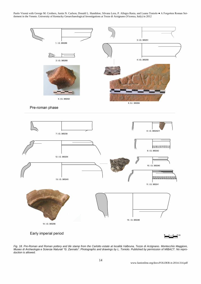
Fig. 18. Pre-Roman and Roman pottery and tile stamp from the Carlotto estate at località Valbruna, Tezze di Arzignano. Montecchio Maggiore, Museo di Archeologia e Scienze Naturali “G. Zannato”. Photographs and drawings by L. Toniolo. Published by permission of MIBACT. No repro-duction is allowed.
Paolo Visonà with George M. Crothers, Justin N. Carlson, Donald L. Handshoe, Silvana Lora, P. Allegra Rasia, and Luana Toniolo ● A Forgotten Roman Set-
tlement in the Veneto. University of Kentucky Geoarchaeological Investigations at Tezze di Arzignano (Vicenza, Italy) in 2012
www.fastionline.org/docs/FOLDER-it-2014-314.pdf 15
of our fragment prevents it from being dated more narrowly, its occurrence at Valbruna is noteworthy. On the whole, both the “ceramica grigia” and this artifact corroborate the possibility that the late Iron age occupants of Valbruna had contacts with Venetic groups from the lowlands, and especially from Padua, who may have been involved with this piedmont area as a gateway to the mining district in the upper Agno Valley
76.
b) The early imperial period
Most of the pottery that can be assigned to the early Empire is datable to the 1
st century A.D. / beginning of the 2
nd
century A.D. The fine wares are represented exclusively by Po Valley sigillata, such as the plate Conspectus 21 with a plain vertical rim (fig. 18, 7; I.G. 365239), which was made from the Augustan period until the late Tiberian or the early Claudian period
77. In the Po Valley the production of these plates seems
to have begun slightly later (under Tiberius), and to have con-tinued until the end of the 1
st century A.D. A fragment of
Firmalampen (fig. 18, 14; inv. 365256) hints at this chronologi-cal horizon but cannot be dated more precisely, since only the lamp’s shoulder is preserved. Although it is uncertain when this lamp began to be made, it had a long typological evolution and lasted until the Antonine age
78. Firmalampen are very common
in the ager of Vicenza, as can be inferred by the examples bearing the stamp FORTIS from the necropolis of Cava Silma at Isola Vicentina
79, and from Rosà
80.
Twenty sherds from Carlotto’s estate can be attributed to thin-walled ware made in northern Italy and include both examples with grey fabrics (20%) and with pale-orange fabrics (80%). Thin-walled grey ware was produced in the 1
st century A.D. and reached its floruit between the reign of Claudius and the Flavian age; it gradually went out of
circulation in the 2nd
century. These grey productions are characteristic of northern Italy. The type of vessel with this fabric that occurs most frequently is a deep bowl with a small rounded rim and a straight wall, usually decorated à la barbotine or with strigillations, corresponding to the type Marabini XXXVI
81. This was widely distributed in the north-
ern Italian area and is also among the pottery found at Valbruna82
. However, it is difficult to find close comparisons for the fragments of bowls from our site, since the type Marabini XXXVI (more a ‘typological family’ than a consistent type of vessel) comprises a broad range of varieties that have never been studied in detail
83. A sherd (fig. 18, 8; I.G.
365242/1) can be attributed to one of the most common and simple variants of this type, featuring a small rounded rim offset by a groove from the walls of the vessel. This fragment has a rather coarse barbotine decoration consist-ing of motifs in between lunettes and pine scales
84. Similar bowls were produced from the Augustan age and the
reign of Tiberius to the first quarter or the first half of the 2nd
century A.D., peaking under Tiberius or Claudius and the Flavians.
The thin-walled ware with pale brown-orange fabrics, on the other hand, is represented at our site by beak-ers or bowls with rouletting decoration (fig. 18, 9-11) for which no close comparisons have been found in the stand-ard catalogues. Some of them share the same typological repertoire of northern Italian coarse wares: the beaker in fig. 18, 11 (I.G. 365241), in particular, is akin to one of the most common types of jar, but has a finer fabric, thin walls, and a red coating.
76
For mineral resources in the upper Agno Valley see MANTESE 1966: 25-26, 30-31; TRIVELLI 1991: 18, 70-71; FRIZZO 2002: 81-82; DEMO 2004: 75-81. Cf. RUTA SERAFINI 1984: 769; BOARO 2001: 170; MIGLIAVACCA 2009: 108-110; DE GUIO, MIGLIAVACCA 2012; MIGLIAVACCA 2012-2014: 6-8, 10-11. 77
See Conspectus: 88-89, Form 21; cf. CIOTOLA 2011: 165-166. 78
S. Loeschcke proposed a date of c. 75 A.D. for this type of lamp: see LOESCHCKE 1919: 268-270. However, a dating close to the mid-1
st century A.D., or even in the early Julio-Claudian period (from Tiberius to Claudius) has been suggested by FARKA 1977: 323-324. On
present evidence, a dating near 60 A.D. seems plausible: see PAVOLINI 1981: 167, and LARESE, SGREVA 1996: 251-253. 79
PETTENÒ, VIGONI 2008: 106, fig. 7, no. 14. 80
PETTENÒ et al. 2002: 74. 81
Cf. RICCI 1985: 322, decorative motif 163, pl. 104, no. 7. 82
Cf. RICCI 1985: 134-135, pl. 25. For its distribution in Lombardy and for finds at Brescia, see TASSINARI 1998 and MORANDINI 1999: 67. Cf. also CIOTOLA 2011: 169. 83
A reorganization of the type Marabini XXXVI for the pottery made in the Bay of Naples area has been proposed by FAGA 2010. 84
Cf. RICCI 1985: type 233 and pl. 108, no. 13.
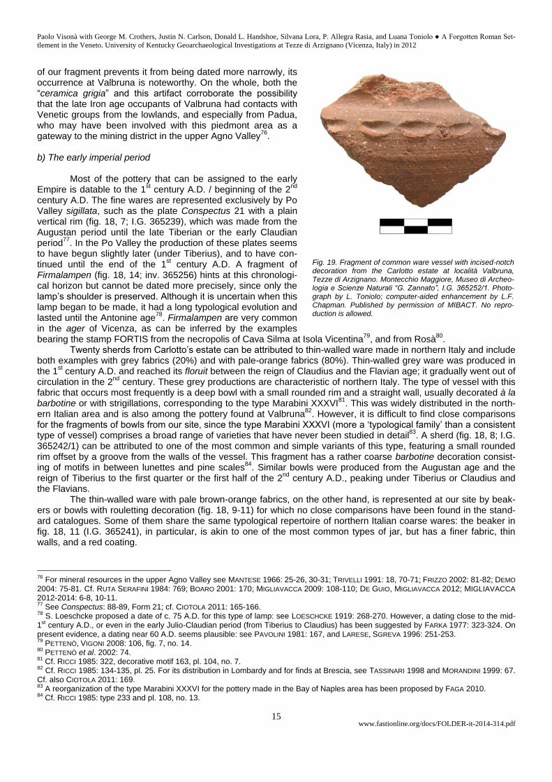
Fig. 19. Fragment of common ware vessel with incised-notch decoration from the Carlotto estate at località Valbruna, Tezze di Arzignano. Montecchio Maggiore, Museo di Archeo-logia e Scienze Naturali “G. Zannato”, I.G. 365252/1. Photo-graph by L. Toniolo; computer-aided enhancement by L.F. Chapman. Published by permission of MIBACT. No repro-duction is allowed.
Paolo Visonà with George M. Crothers, Justin N. Carlson, Donald L. Handshoe, Silvana Lora, P. Allegra Rasia, and Luana Toniolo ● A Forgotten Roman Set-
tlement in the Veneto. University of Kentucky Geoarchaeological Investigations at Tezze di Arzignano (Vicenza, Italy) in 2012
www.fastionline.org/docs/FOLDER-it-2014-314.pdf 16
Only two diagnostic sherds of early imperial amphoras made in the northern Adriatic region have been re-covered
85. The best preserved one is an early example of a Dressel 6A amphora (fig. 18, 15; I.G. 365246), datable
to the end of the 1st century B.C. / beginning of the 1
st century A.D. An evolution of the Lamboglia 2 amphora that
characterized Adriatic contexts of the second half of the 1st century B.C., it probably contained wine. Another sherd,
very fragmented, can be attributed to a northern Adriatic Dressel 6B, an amphora with a funnel-shaped rim that was common in the second half of the 1
st century A.D. This type of amphora was produced in northern Italy and in Istria,
and it is frequently found in northern Italy from Mediolanum to Altinum; it may have been filled with oil or other food-stuffs
86. All the common wares have a coarse fabric resembling that of the pottery made during the ‘Romanization’
phase, which suggests that the same sources of raw materials continued to be exploited under the early Empire. The technology and firing techniques used to produce these vessels also remained traditional. Their typological rep-ertoire, however, is fully Roman and finds close comparisons in archaeological contexts across northern Italy. Chronological markers are provided by vessels with an everted moulded rim with single or double grooving and a globular body that is usually decorated on the shoulder (fig. 18, 12; I.G. 365254), which are generally datable from the 1
st century A.D. to the beginning of the 2
nd century, but continued to be produced until the 4
th century A.D in
some contexts. In fact, this type of vessel belongs to a typological family that exhibits slight morphological variants from site to site. In the X Regio it has been found at Ca’ Tron and in the Verona area
87; the variety of fabrics points
to different production centers that are still unknown. It is also common in Lombardy (especially in contexts datable between the 1
st and 3
rd centuries A.D.)
88, at Modena
89, and at Albintimilium
90. Another type of common ware vessel
from Valbruna with a simpler rim and a globular body (fig. 18, 13; I.G. 365245) belongs to the same chronological horizon and shares the same fabric and area of distribution within the X Regio, and beyond its boundaries
91.
The only imported vessel datable to the first two centuries of the Empire is a poorly preserved rim of a mortarium of central Italic provenience, similar to Dramont D2 (Joncheray type 2). Its yellow-pinkish fabric (Munsell 7.5 YR 7/6) with large inclusions of mica and quartz is distinctive. This implement has a very large and thick rim (of-ten stamped), a big spout, a shallow body, and a flat base; it was produced from the mid-1
st century A.D. to the
Antonine age. The occurrence of a mortarium made in central Italy among the Roman materials from our site sug-gests that the lower Agno Valley was tied to a regional network of trade under the early Empire, since this type of vessel is found across the entire X Regio. The main harbor in the Veneto through which these mortaria reached the interior of the Po Valley was probably Altinum, which has yielded a large number of them
92.
Two stamped tile fragments in the assemblage can also be assigned to the late Republican period or to the first half of the 1
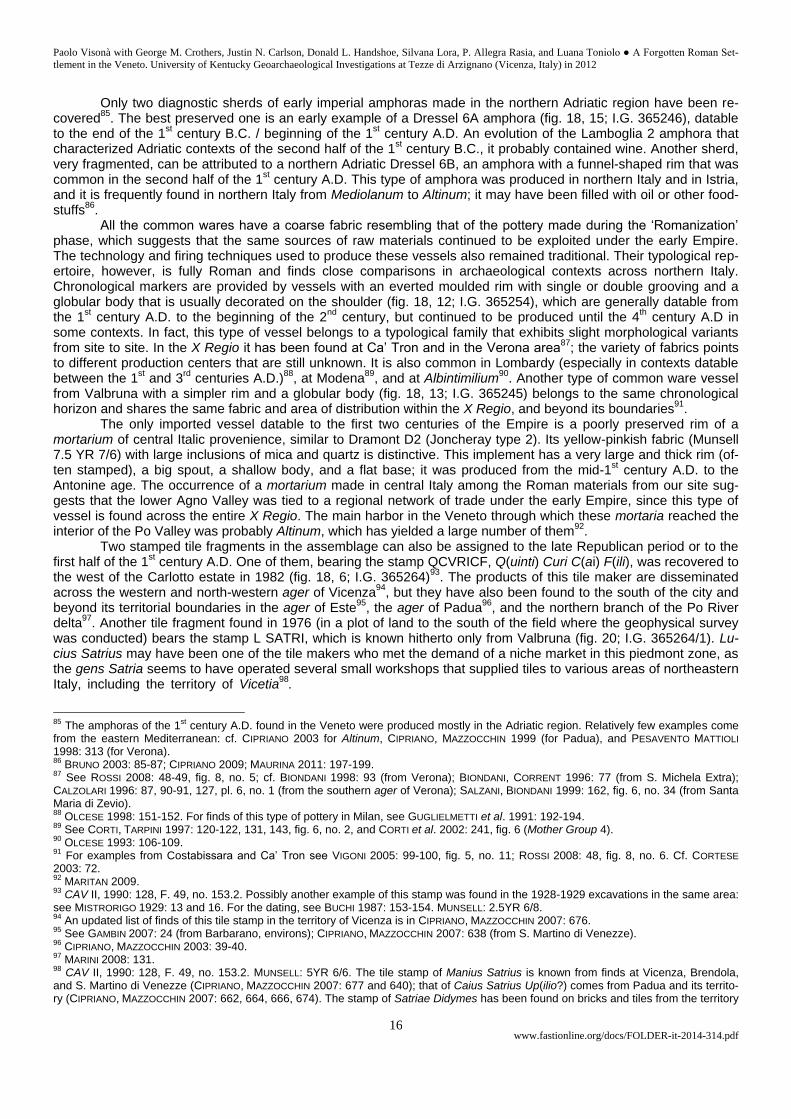
st century A.D. One of them, bearing the stamp QCVRICF, Q(uinti) Curi C(ai) F(ili), was recovered to
the west of the Carlotto estate in 1982 (fig. 18, 6; I.G. 365264)93
. The products of this tile maker are disseminated across the western and north-western ager of Vicenza
94, but they have also been found to the south of the city and
beyond its territorial boundaries in the ager of Este95
, the ager of Padua96
, and the northern branch of the Po River delta
97. Another tile fragment found in 1976 (in a plot of land to the south of the field where the geophysical survey
was conducted) bears the stamp L SATRI, which is known hitherto only from Valbruna (fig. 20; I.G. 365264/1). Lu-cius Satrius may have been one of the tile makers who met the demand of a niche market in this piedmont zone, as the gens Satria seems to have operated several small workshops that supplied tiles to various areas of northeastern Italy, including the territory of Vicetia
98.………………………………………………………………………………………..
85
The amphoras of the 1st century A.D. found in the Veneto were produced mostly in the Adriatic region. Relatively few examples come
from the eastern Mediterranean: cf. CIPRIANO 2003 for Altinum, CIPRIANO, MAZZOCCHIN 1999 (for Padua), and PESAVENTO MATTIOLI 1998: 313 (for Verona). 86
BRUNO 2003: 85-87; CIPRIANO 2009; MAURINA 2011: 197-199. 87
See ROSSI 2008: 48-49, fig. 8, no. 5; cf. BIONDANI 1998: 93 (from Verona); BIONDANI, CORRENT 1996: 77 (from S. Michela Extra); CALZOLARI 1996: 87, 90-91, 127, pl. 6, no. 1 (from the southern ager of Verona); SALZANI, BIONDANI 1999: 162, fig. 6, no. 34 (from Santa Maria di Zevio). 88
OLCESE 1998: 151-152. For finds of this type of pottery in Milan, see GUGLIELMETTI et al. 1991: 192-194. 89
See CORTI, TARPINI 1997: 120-122, 131, 143, fig. 6, no. 2, and CORTI et al. 2002: 241, fig. 6 (Mother Group 4). 90
OLCESE 1993: 106-109. 91
For examples from Costabissara and Ca’ Tron see VIGONI 2005: 99-100, fig. 5, no. 11; ROSSI 2008: 48, fig. 8, no. 6. Cf. CORTESE 2003: 72. 92
MARITAN 2009. 93
CAV II, 1990: 128, F. 49, no. 153.2. Possibly another example of this stamp was found in the 1928-1929 excavations in the same area: see MISTRORIGO 1929: 13 and 16. For the dating, see BUCHI 1987: 153-154. MUNSELL: 2.5YR 6/8. 94
An updated list of finds of this tile stamp in the territory of Vicenza is in CIPRIANO, MAZZOCCHIN 2007: 676. 95
See GAMBIN 2007: 24 (from Barbarano, environs); CIPRIANO, MAZZOCCHIN 2007: 638 (from S. Martino di Venezze). 96
CIPRIANO, MAZZOCCHIN 2003: 39-40. 97
MARINI 2008: 131. 98
CAV II, 1990: 128, F. 49, no. 153.2. MUNSELL: 5YR 6/6. The tile stamp of Manius Satrius is known from finds at Vicenza, Brendola, and S. Martino di Venezze (CIPRIANO, MAZZOCCHIN 2007: 677 and 640); that of Caius Satrius Up(ilio?) comes from Padua and its territo-ry (CIPRIANO, MAZZOCCHIN 2007: 662, 664, 666, 674). The stamp of Satriae Didymes has been found on bricks and tiles from the territory
Paolo Visonà with George M. Crothers, Justin N. Carlson, Donald L. Handshoe, Silvana Lora, P. Allegra Rasia, and Luana Toniolo ● A Forgotten Roman Set-
tlement in the Veneto. University of Kentucky Geoarchaeological Investigations at Tezze di Arzignano (Vicenza, Italy) in 2012
www.fastionline.org/docs/FOLDER-it-2014-314.pdf 17
c) The mid-imperial period
In contrast with the relative abundance of sherds datable to the 1
st and 2
nd centuries A.D., very few data are available for the mid-
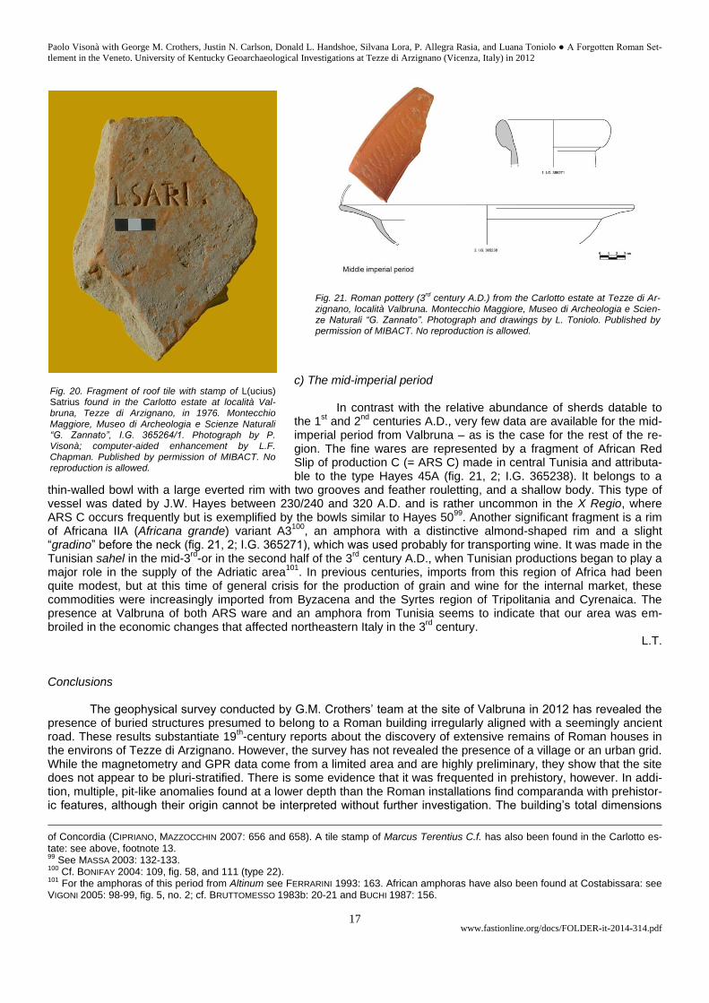
imperial period from Valbruna – as is the case for the rest of the re-gion. The fine wares are represented by a fragment of African Red Slip of production C (= ARS C) made in central Tunisia and attributa-ble to the type Hayes 45A (fig. 21, 2; I.G. 365238). It belongs to a
thin-walled bowl with a large everted rim with two grooves and feather rouletting, and a shallow body. This type of vessel was dated by J.W. Hayes between 230/240 and 320 A.D. and is rather uncommon in the X Regio, where ARS C occurs frequently but is exemplified by the bowls similar to Hayes 50
99. Another significant fragment is a rim
of Africana IIA (Africana grande) variant A3100
, an amphora with a distinctive almond-shaped rim and a slight “gradino” before the neck (fig. 21, 2; I.G. 365271), which was used probably for transporting wine. It was made in the Tunisian sahel in the mid-3
rd-or in the second half of the 3
rd century A.D., when Tunisian productions began to play a
major role in the supply of the Adriatic area101
. In previous centuries, imports from this region of Africa had been quite modest, but at this time of general crisis for the production of grain and wine for the internal market, these commodities were increasingly imported from Byzacena and the Syrtes region of Tripolitania and Cyrenaica. The presence at Valbruna of both ARS ware and an amphora from Tunisia seems to indicate that our area was em-broiled in the economic changes that affected northeastern Italy in the 3
rd century.
L.T. Conclusions
The geophysical survey conducted by G.M. Crothers’ team at the site of Valbruna in 2012 has revealed the presence of buried structures presumed to belong to a Roman building irregularly aligned with a seemingly ancient road. These results substantiate 19
th-century reports about the discovery of extensive remains of Roman houses in
the environs of Tezze di Arzignano. However, the survey has not revealed the presence of a village or an urban grid. While the magnetometry and GPR data come from a limited area and are highly preliminary, they show that the site does not appear to be pluri-stratified. There is some evidence that it was frequented in prehistory, however. In addi-tion, multiple, pit-like anomalies found at a lower depth than the Roman installations find comparanda with prehistor-ic features, although their origin cannot be interpreted without further investigation. The building’s total dimensions
of Concordia (CIPRIANO, MAZZOCCHIN 2007: 656 and 658). A tile stamp of Marcus Terentius C.f. has also been found in the Carlotto es-tate: see above, footnote 13. 99
See MASSA 2003: 132-133. 100
Cf. BONIFAY 2004: 109, fig. 58, and 111 (type 22). 101
For the amphoras of this period from Altinum see FERRARINI 1993: 163. African amphoras have also been found at Costabissara: see VIGONI 2005: 98-99, fig. 5, no. 2; cf. BRUTTOMESSO 1983b: 20-21 and BUCHI 1987: 156.
Fig. 20. Fragment of roof tile with stamp of L(ucius) Satrius found in the Carlotto estate at località Val-bruna, Tezze di Arzignano, in 1976. Montecchio Maggiore, Museo di Archeologia e Scienze Naturali “G. Zannato”, I.G. 365264/1. Photograph by P. Visonà; computer-aided enhancement by L.F. Chapman. Published by permission of MIBACT. No reproduction is allowed.
Fig. 21. Roman pottery (3rd
century A.D.) from the Carlotto estate at Tezze di Ar-zignano, località Valbruna. Montecchio Maggiore, Museo di Archeologia e Scien-ze Naturali “G. Zannato”. Photograph and drawings by L. Toniolo. Published by permission of MIBACT. No reproduction is allowed.
Paolo Visonà with George M. Crothers, Justin N. Carlson, Donald L. Handshoe, Silvana Lora, P. Allegra Rasia, and Luana Toniolo ● A Forgotten Roman Set-
tlement in the Veneto. University of Kentucky Geoarchaeological Investigations at Tezze di Arzignano (Vicenza, Italy) in 2012
www.fastionline.org/docs/FOLDER-it-2014-314.pdf 18
are uncertain and its functions also remain problematic, despite the fact that the surface finds of mosaic tesserae seem consistent with its identification as a villa. Finds of Roman tombs in its vicinity raise the possibility that it may have been situated near a burial ground on the outskirts of the settlement uncovered in 1795 and 1882, whose exact location remains elusive.
L. Toniolo’s study of the pottery suggests that the site was continuously occupied from the ‘Romanization’ phase in the late Iron age until the 3
rd century A.D. and that Valbruna’s occupants continued to rely on local ceramic
productions under the Empire. Although the largest number of potsherds belongs to the 1st and 2
nd centuries A.D.
102,
the overall quantity of imported wares appears to have been relatively small throughout the same period. A reduced level of economic activity may perhaps be inferred from the dearth of sherds datable after the Severan period
103.
Nonetheless, this area was seemingly well integrated within a regional network of trade and redistribution even in epochs of prolonged warfare, such as the mid-3
rd century. It is not known at present whether the site was destroyed
and abandoned in the wake of the conflicts in which the Veneto was involved between 249 and 260 A.D.104
. If the remains do belong to the pars urbana of an isolated farmstead
105, the building’s demise would fit the general pattern
of abandonment of Roman villae in this period. The data gained from the Tezze Archaeological Project warrant further research and have implications for
an understanding of the pattern of settlement in the lower Agno Valley under the Romans. Even though the location of the ruins brought to light in the late 18
th and 19th centuries is still unknown, there are indications that a nucleated
settlement existed on the valley floor. The likely presence of a village or “centro vicanico”, presumably with its own ager, in this corner of the Agno-Guà Valley would point to a more complex organization of the countryside than a mere subdivision of the agricultural land into rural estates
106. A Roman settlement in the environs of Tezze di
Arzignano would have been well positioned to exploit valuable natural resources107
, and to serve as a node for commercial exchanges with Vicenza and Verona, the closest ‘central places’ on the Via Postumia
108. Its inhabitants
may have included and probably interacted with the descendants of the pre-Roman population that had lived in the piedmont since the late Iron age. APPENDIX 1 G.B. GARDUCCI VELO, “Rovine della così detta Valbruna (Vico Prunella)”, in Epoche, e Memorie dell’antica, e moderna Vi-cenza. Biblioteca Civica Bertoliana, Vicenza, MS 2686 (Gonzati 21.11.3), Fasc. V: 31-34. “In Valle di Trissino, nel tenere delle Tezze d’Arzignano, a settentrione del villaggio, e nei poderi specialmente dei Fratelli Carlotti si trovò nel 1795, per accidentale esundazione del fiume Agno messa improvvisamente a giorno larga estensione di rovinati ed arsi edifici, e considerabili macerie d’antico Luogo o Vico. Quattro piedi circa sotto il livello ordinario de’ cam-pi si scoprono tali ruine. L’estesa maggiore è di levante in ponente, occupando in tal direzione una linea di più di 320. per-tiche; mentre dal mezzodì al settentrione non si prolungano che 240. Il che viene a formare più d’un miglio di circuito, e dimostra ch’era Vico, o Borgata non mediocre, e di qualche considerazione. La base de’ fondamenti posa sopra uno strato di argilla vulcanica nerastra sottoposta immediat.e agli ammassi delle ghiaie sopra accumulatevi dalle alluvioni del torren-te. I muri ne son composti o di gran breccie di strato calcareo bianco; o di ciottoloni di sasso nero basaltino (sic), o di lava vulcanica misti a sassi calcarei fluitati. Il cemento durissimo è di calce, ed arena calcarea grossa. La lor grossezza in base
102
A sample of Roman pottery from Valbruna seen by J.W. Hayes in 1984 was datable mainly to the 1st century A.D.: see VISONÀ 1987:
201, n. 62. 103
The coin finds also taper off after the second quarter of the 3rd
century, to which a sestertius of Maximinus I and a bronze of Gordian III from Viminacium can be assigned: see above, footnote 52, and VISONÀ 2000: 68-70. An AE 4 with SALVS REIPVBLICAE also comes from Valbruna: see VISONÀ 1984: 42, n. 10. A fragmented handle of a Blechkanne (similar to Bolla IIb1) with traces of repair, datable to the 3
rd century, was found to the north of the Carlotto estate in the early 1980s; it is in a private collection. Cf. BOLLA 1989: 97-98, 107
and pl. L, figs. 15-18. For these bronze bottles, see also CASSANI 2002: 511-515; CASTOLDI 2002: 289-290. 104
See CRACCO RUGGINI 1987: 259-260. Farms in northern Italy were generally small and produced mainly grain and wine for local mar-kets, according to ROSELAAR 2008: 163, n. 609. The buildings uncovered in 1795 were burnt (“arsi”), according to Garducci Velo (AP-PENDIX 1). The architectural structures unearthed in the Poscola quarry (c. 2 km to the southeast of Valbruna), in which a 5
th century
A.D. burial of an eastern European horseman was deposited, also probably belong to an abandoned or destroyed farmstead; ved. POS-
SENTI 2011: 431. 105 See n. 25 above. 106
See MENEGAZZI 1990: 90: “dalla seconda metà del I sec. a.C. si va organizzando nel territorio un modello insediativo il quale, pur non arrivando mai ad aggregazioni in centri organizzati, certamente utilizza più razionalmente ed intensivamente delle fasi precedenti gli spazi pianeggianti”. However, cf. MAGGI, ZACCARIA 1999: 14-15 and REALI 2004: 72-73. 107
For clay deposits and sources of limestone and marble, see FABIANI 1930: 71-82, 86, 89, 93, 95. Cf. also above, footnote 75, and BONETTO 1999. 108
Cf. the remarks by MALKIN 2011: 20-45; RIVERS et al. 2013: 127-132.
Paolo Visonà with George M. Crothers, Justin N. Carlson, Donald L. Handshoe, Silvana Lora, P. Allegra Rasia, and Luana Toniolo ● A Forgotten Roman Set-
tlement in the Veneto. University of Kentucky Geoarchaeological Investigations at Tezze di Arzignano (Vicenza, Italy) in 2012
www.fastionline.org/docs/FOLDER-it-2014-314.pdf 19
è dai due piedi, e mezzo fino ai quattro e mezzo109
. La direzione dei maggiori corre da settentrione a mezzodì, e viene in-tersecata ad angoli retti da quella dei minori, i quali vanno da levante a ponente. Le stanze sono di varia grandezza; di 12 di 15. ed anche di 30. piedi
110 Vi si osservan qualche arco di porta, e sotterranee
cavità profonde, e capaci. Quelle stanze che sonsi potute vedere allo scoperto, veggionsi tutte pavimentate di un mastico, o terrazzo durissimo, non composto di breccie marmoree, ma di sassolini fluitati di vario colore. Vi ho trovato quantità di bei marmi, i quali sembran de’ monti circomvicini. Tra l’altre riflettei parecchie piastrelle di un marmo fino, variegato di rosso, e bianco, che servivano forse all’intarsio delle pareti, o dei pavimenti, vasi di terra cotta d’infinite forme, e terre diverse; urne e pentole da cucina, ed alcune anche arse dal fuoco, e coperte di fuligine; èmbrici an-tichi, con cornice, e lavori; immensa congerie di carboni, e di ferro fuso; ossa umane; lastre di cristallo bellissimo; coperchi, e vasi marmorei; cannoni di piombo; pezzi di bronzo fuso, ed anche lavorato, di cui uno conservo, che sembra esser frammento di statua colossale; parecchie monete di Giulio Cesare, Giustiniano, e di Tastio Rufo Triumviro, una, che qui si riporta, e che parimenti conservo; pezzi d’intonaco di calce, ed arena finissima somigliante alla marmorina fatta di scagliò-la. Tra gli altri si distinse uno dipinto a guazzo di bella tinta rossa, detta dagli antichi rùbrica colle sigle WPL (NB: in ligature). Ciò potrebbe aggiunger luce alla corruzione del nome di codesto Vico o Pago ne’ barbari tempi. Poiche (sic) scrivendosi così V.Pruna cioe (sic) Vicus Prunarum, o Prunorum, o Prunellus, fu letto ignorantemente dai rozzi Vallis Bruna; di cui ri-mane ancor fama nella tradizione, e nei Cronisti. Essendovisi trovate monete di Giustiniano; (sic) pare che codesto Vico sia stato arso, e fino ai fondamenti atterrato dai barbari, i quali al tempo di quest’Imperatore invasero l’Impero di occidente. Pare, che vi passasse per mezzo una strada Vicinale della Postumia, la quale venendo dai colli Veronesi per Celere, Ila-sio, Castel Quirino, e Zermeghedo, di quinci usciva per Val di Alonte, per Subizzo, Creaazzo (sic), il Monte della Maddale-na, e giungeva a Vicenza dalla banda di settentrione -------” APPENDIX 2 G. FIORELLI, “Arzignano”, in Notizie degli Scavi di Antichità 8, 1883: 11-12. In Cusago alle Tezze, frazione del comune di Arzignano nella provincia di Vicenza, le recenti inondazioni resero necessa-rî, da parte dei privati, alcuni lavori di sterro e di riporto, che misero in luce parecchi oggetti di antichità, i quali furono rac-colti dal curato del luogo, rev. G. Zanpa (sic)
111, che ne fece parola nel giornale Il Berico, esagerandone forse l’importanza.
Ma l’ispettore di Vicenza ing. Francesco Molon, che unitamente all’ispettore locale sig. P. Zuffellato si recò sul luogo delle scoperte, compilò su di esse la relazione che qui trascrivo. “Nella vallata del Guà, e precisamente dove questo fiume corre fra le colline di Arzignano e quelle di Montecchio Maggio-re, in occasione delle passate inondazioni le acque rompendo l’argine sinistro, si aprirono un varco al sud verso Tezze di Arzignano, e scorsero lungo una vecchia strada assai depressa, detta la Strada fonda. I danni che ne seguirono reclamarono alcuni lavori, che posero a giorno parecchi oggetti archeologici non solo, ma pure gli avanzi di vecchie mura, sparse qua e là in un’area che potrebbesi calcolare a sei ettari circa. La precisa ubicazione di tali mura corrisponderebbe alla prolungazione dell’asse della Vallata ad occidente, detta della Restena, e precisamente dove questa ha il suo sbocco al piano. Gli oggetti archeologici rinvenuti sono di trovamento sporadico, sparsi nel terreno rimaneggiato, nè si trovarono, come si dice, sul posto entro monumenti o sepolcreto. Fra questi si notano molti frammenti di vasi vinari, di anfore e di vasi comuni di argilla abbastanza fina, due perle in succi-no nero incise a fettuccie oblunghe, una lucerna comune, ed una coppa da offerte in argilla a fondo nero decorato a tinta rossa, il frammento di una coppa in ferro e poche monete di Augusto, di Domiziano, di Traiano e di Commodo. Si rinven-nero inoltre alcuni lacrimatoi. Si trovarono pure frammenti di ossa umane sparse nel terreno rimaneggiato. Fra i vasi fittili è degno di nota un orciuolo con manico in alto, quasi in aderenza all’orlo, simile ai vasi comuni dell’età ro-mana. Ciò però che torna di qualche interesse è la scoperta di avanzi di antiche costruzioni, ad una profondità non maggiore di circa un metro, costituite di ciottoli in cemento di calce viva come si usava dai Romani. Tali ruderi appartengono a quanto sembra ad abitazioni antiche, scoprendovisi talvolta pavimenti a battuto finemente eseguito. Tracce di vôlte sotterranee accennano a condotti di acque, che potrebbero far sospettare la preesistenza di un fabbricato ad uso termale, e ciò ver-rebbe giustificato dalle traccie di un locale quadrato, dove si trovarono frammenti di una pietra refrattaria, che potrebbero indicare l’esistenza ivi di un piccolo calidarium. Dalle asserzioni dei proprietari limitrofi sembra però, che non mancassero tombe a lastre di pietra ai lati della Strada fonda, le quali nondimeno furono da tempo esplorate e manomesse. Dai pochi oggetti che si osservarono sembra potersi giudicare, che quivi fra il terzo e quarto secolo dell’era cristiana fosse un centro abitato. Il quale secondo le tradizioni raccolte dall’illustre Maccà fu denominato Valbruna
112, nome forse nato dal
trovarsi questa stazione di fronte alla valle della Restena tutta di neri tufi e di basalti”.
109
According to the metric system (see above, footnote 19), wall thickness (at base) ranged from 89.25 cm to 160 cm. 110
Room sizes ranged from 4.28 m to 5.3 m to 10 m. 111
Probably don Giuseppe Zaupa, a priest who witnessed the 1882 flood and reported on the finds from Valbruna: see MANTESE 1985, Tomo II: 718 and ZAUPA 1883. 112
G. Maccà did not mention the ruins uncovered at Valbruna in his discussion of the Roman antiquities from Arzignano and Tezze: see MACCÀ 1813: 31-38, 41-42, 46.
Paolo Visonà with George M. Crothers, Justin N. Carlson, Donald L. Handshoe, Silvana Lora, P. Allegra Rasia, and Luana Toniolo ● A Forgotten Roman Set-
tlement in the Veneto. University of Kentucky Geoarchaeological Investigations at Tezze di Arzignano (Vicenza, Italy) in 2012
www.fastionline.org/docs/FOLDER-it-2014-314.pdf 20
APPENDIX 3 G. ZAUPA, “Relazione storica sul Comune di Arzignano, del 24 dicembre 1882”, in Guida amministrativa della città e pro-vincia di Vicenza per l’anno 1883 compilata per cura del segretario comunale di Arzignano Rosa Francesco, Arzignano: 16-17 (reprinted in NORI 1987: 13-14). […] Intanto i proprietarii dei fondi cominciarono a scavare delle fosse per seppellirvi la ghiaia trasportatavi dall’acqua e nel-la località del Cusago vicino a quella di Valbruna si rinvennero degli oggetti che ci confermano l’esistenza della necropoli di Valbruna. E qui sarebbe da dire alcun che di questa Val-Bruna che da alcuni vuolsi esser stata una antica città di questi luoghi. Ma le conghietture sono ancora troppo vaghe ed incorte (sic). Un’attuale contrada però di Tezze detta delle Mura, ed un’altra detta del Borgo, la località surriferita dove si fanno gli scavi – detta Valbruna – sepolcri di cotto fatti a foggia di croce che scavando si trovano assieme di coppi romani (sic)
113, lumiere, calamai, bottiglie di diverse foggie e grandezze,
tegami in cotto ed in bronzo di forma elegantissima, pezzi di marmo Pario, ed una filo-granata intera trovata testè al collo d’uno scheletro umano, non sono è vero indizii ancor tanto certi da fondarvi sopra la esistenza d’una antica città, ma pure svegliano il desiderio che vengano continuate o per meglio dire spinte le indagini. Non puossi però negare che gli Arzignanesi non si stettero a tanta novità indifferenti, che anzi vollero si continuassero gli escavi, e perciò furono eseguiti tre assaggi in una località dove la tradizione dei borghigiani ammettea si dovessero fare, e si rinvenne alla profondità di un metro sotterra il tetto d’una casa compostodi un terrazzo dello spessore di m. 0,30, i cui muri sporgenti al di sopra di esso un 20 centim. coperti di coppi romani servivano come di merlatura. Lì vicino si ebbe ad osservare altro fabbricato, le cui pareti sono a marmorina, e vicini a questo quattro muri paralleli tra loro colla differenza che i due di mezzo, uniti agli esterni, sono un po’ più bassi a guisa di gradini colla distanza l’uno dall’altro di 40 centim. Oltre agli oggetti sovraesposti, altri si rinvennero, coll’aggiunta di cinque scheletri umani l’uno dall’altro separate; l’ossa pe-rò di ognuno erano tutte unite e non erano sotterra che dai 35 ai 50 centimetri; locchè dà a conoscere che furono o anne-gati, quegli uomini, ovvero salvati dall’onde sulla cima delle case, dove sen perirono di fame. Quando poi sia accaduta questa innondazione in (sic) non vel saprei dire: solamente vi dirò che la città di Val-Bruna esistea ai tempi del primo im-peratore di Roma Cesare Augusto, e questo lo si deduce dalle monete testè trovate, dove si legge la presente iscrizione: DIVUS AUGUSTUS PATER. […]
Acknowledgments
This report is dedicated to the memory of G. Battista Carlotto (1929-2013), whose interest in preserving the antiquities found in his land provided the stimulus for the Tezze Archaeological Project. Special thanks for information and assistance in the preparation of this es-say are owed to Dr. Armando Bernardelli (Museo Naturalistico e Archeologico di S. Corona, Vicenza), Mr. Francesco Bertinato (Tezze di Arzignano, VI), Dr. Margherita Bolla (Museo Archeologico al Teatro Romano di Verona), Dr. Annachiara Bruttomesso (Museo di Ar-cheologia e Scienze Naturali “G. Zannato”, Montecchio Maggiore, VI), Dr. Enrico Bruttomesso (Arzignano, VI), Mr. Ferdinando Businaro (Director of Marzotto S.p.A.), the late G. Battista Carlotto (Tezze di Arzignano, VI), Lesley F. Chapman (Visual Resources Curator, De-partment of Art and Art History, Colgate University, New York, U.S.A.), Dr. Luciano Chilese (Montecchio Maggiore, VI), Ms. Laura Cora Perin (Trissino, VI), Prof. Steven J.R. Ellis (Department of Classics, University of Cincinnati, Ohio, U.S.A.), Dr. Silvano Fornasa (Castel-gomberto, VI), Istituto Geografico Militare (Firenze), Dr. Alexandre Galiotto (Arzignano, VI), Dr. Mariolina Gamba (Soprintendenza per i Beni Archeologici del Veneto, Padova), Mr. James R. Jansson (The Foundation for Calabrian Archaeology, Parker, Colorado, U.S.A.), Mr. Antonio Lora (Ghisa, VI), Mr. Erminio Negri (Valdagno, VI), the late Dr. Franca Ronconi (Valdagno), Dr. Davide Sandini (Mossano, VI), Don Piero Savio (Church of Madonna dei Prati, Costo di Arzignano, VI), and Mr. Gianni Urbani (Valdagno, VI), and - for her thou-ghtful remarks - Elizabeth Fentress. Generous support for the geophysical investigations conducted in the Carlotto estate in 2012 was provided by Dr. Giorgio Gentilin, Mayor of the City of Arzignano, by Dean Michael Tick (College of Fine Arts) and Dean Mark Kornbluh (College of Arts and Sciences) of the University of Kentucky, and by the Foundation for Calabrian Archaeology (Parker, Colorado, U.S.A.).
Paolo Visonà University of Kentucky
E-mail: [email protected]
BIBLIOGRAPHY Aquileia 2007: G. CUSCITO, C. ZACCARIA (eds.), Aquileia dalle origini alla costituzione del ducato longobardo. Territo-
rio – economia – società [Antichità Altoadriatiche 65], Trieste. ASAV: Archivio della Soprintendenza per i Beni Archeologici del Veneto.
113
Here Zaupa may be quoting the historian F. Barbarano (1596-1656), who described the church of Madonna dei Prati (c. 1.8 km to the south of Tezze), as follows: “s. Maria di Nale, anticamente detta di Val Bruna, come si chiamava la Valle di Dressino, per la terra Val Bruna, ivi vicina. Qui è un’immagine della B.V. Miracolosa, spesso cavando (sic) nel circuito si trovano opere di Mosaico, e già non molti anni si trovarono alcuni sepolcri fatti di pietra Cotta in forma di croce, di modo, che seppellivano i morti con le braccia stese, come se fossero Crocefissi.” See BARBARANO 1762: 62.
Paolo Visonà with George M. Crothers, Justin N. Carlson, Donald L. Handshoe, Silvana Lora, P. Allegra Rasia, and Luana Toniolo ● A Forgotten Roman Set-
tlement in the Veneto. University of Kentucky Geoarchaeological Investigations at Tezze di Arzignano (Vicenza, Italy) in 2012
www.fastionline.org/docs/FOLDER-it-2014-314.pdf 21
ASOLATI M., 2009, “Le monete”, in A. DE GUIO, M. MIGLIAVACCA (eds.), “Per la storia e la valorizzazione di un pae-saggio senza tempo. Basto al Campetto. Risultati della campagna 2008”, in Quaderni di Archeologia del Vene-to 25: 194-195.
BAGOLINI B., 1987, “Il Neolitico”, in Storia di Vicenza 1987: 71-83. BANDELLI G., 2007, “Considerazioni storiche sull’urbanizzazione cisalpina di età repubblicana (283-89 a.C.)”, in L.
BRECCIAROLI TABORELLI (ed.), Forme e tempi dell’urbanizazione nella Cisalpina (II secolo a.C. – I secolo d.C.). Atti delle Giornate di Studio Torino 4-6 maggio 2006, Firenze: 15-28.
BARBARANO F., 1762. Historia Ecclesiastica della Città Territorio e Diocese di Vicenza. Libro Sesto nel quale si de-scrivono le Chiese, Oratorj, ed Hospitali del Territorio, e della Diocese, Vicenza (published posthumously).
BIANCHIN CITTON E. (ed.), 1989, “S. Martino di Lupari (Padova) – Castello di Godego (Treviso): il sito arginato de “Le Motte di Sotto”. Relazione delle prime indagini di scavo”, in Quaderni di Archeologia del Veneto 5: 216-261.
BIANCHIN CITTON E. (ed.), 1996, “Indagine interdisciplinare nell’insediamento neolitico di Roncade (Treviso) – Locali-tà Biancade”, in Quaderni di Archeologia del Veneto 12: 94-119.
BIONDANI F., 1998, “Verona, via Ponte Pietra 19. Rinvenimenti di strutture in opera reticolata”, in Quaderni di Archeo-logia del Veneto 14: 55-66.
BIONDANI F., CORRENT G., 1996, “Ricerche di superficie nel territorio a sud di San Michele Extra”, in Quaderni di Ar-cheologia del Veneto 12: 73-80.
BOARO S., 2001, “Dinamiche insediative e confini nel Veneto dell’età del Ferro: Este, Padova e Vicenza”, in Padusa 37: 153-197.
BOLLA M., 1989, “ “Blechkannen”: aggiornamenti”, in Rassegna di Studi del Civico Museo Archeologico e del Civico Gabinetto Numismatico di Milano 43-44: 95-118.
BOLLA M., 2002, “Bronzetti romani di divinità in Italia Settentrionale: alcune osservazioni”, in Bronzi di età romana in Cisalpina 2002: 73-159.
BOLLA M., 2009, “Bronzetti romani da Montecchio Maggiore e Isola Vicentina”, in Studi e ricerche 16: 67-82. BONDINI A., 2005, “I materiali di Montebello Vicentino. Tra cultura veneto-alpina e civiltà di La Tène”, in D. VITALI
(ed.), Studi sulla media e tarda età del ferro nell’Italia settentrionale [Studi e Scavi, N.S. 12], Bologna: 215-324. BONETTO J., 1998, “La via Postumia e gli agri centuriati della X regio: rapporti topografici e funzionali”, in Tesori della
Postumia 1998: 251-255. BONETTO J., 1999, “Gli insediamenti alpini e la pianura Veneto-friulana: complementarità economica sulle rotte della
transumanza”, in Studio e conservazione 1999: 95-106. BONETTO J., 2009, Archeologia delle Regioni d’Italia. Veneto, Roma. BONIFAY M., 2004, Études sur la ceramique tardive d’Afrique [British Archaeological Reports International Series
1301], Oxford. BOSIO L., 1984, “Capire la terra: la centuriazione romana nel Veneto”, in Misurare la terra: centuriazione e coloni nel
mondo romano. Il caso veneto, Modena: 15-21. Bronzi di età romana in Cisalpina 2002: G. CUSCITO, M. VERZÀR-BASS (eds.), 2002, Bronzi di età romana in Cisalpi-
na. Novità e riletture [= Antichità altoadriatiche 51], Trieste. BROWN A.G., 1997, Alluvial Geoarchaeology. Floodplain Archaeology and Environmental Change, Cambridge. BROMBO D., 2012, “Le strutture dell’età del Ferro”, in B. BRUNO, D. BROMBO, “S. Ambrogio di Valpolicella (Verona):
abitato dell’età del Ferro e complesso abitativo di età romana”, in Quaderni di Archeologia del Veneto 28: 160-162.
BRUNO B., 2003, “Le anfore della cava di UC VII. Considerazioni sulle anfore nei contesti databili tra la tarda età an-tonina e la prima età severiana”, in Dall’antichità al Medioevo 2003: 85-97.
BRUNO B., CAVALIERI MANASSE G., 2000, “ Peschiera del Garda: scavi recenti nel vicus di Arilica”, in Quaderni di Ar-cheologia del Veneto 16: 78-83.
BRUTTOMESSO A., 1983a, “Materiali per lo studio di Vicenza paleoveneta”, in Archeologia Veneta 6: 7-30. BRUTTOMESSO A., 1983b, Guida alla mostra archeologica dei reperti rinvenuti nel territorio di Costabissara. Costa-
bissara, 25 ottobre – 8 novembre 1981 [Gruppo Archeologico Bissari]. BRUTTOMESSO A., 2010, “Testimonianze archeologiche”, in Montecchio Maggiore, un Colle, due Castelli, Vicenza:
35-52. BRUTTOMESSO A., PETTENÒ E., VERONESE F., 2002, “Di alcuni materiali da Costabissara (Vicenza)”, in Quaderni di
Archeologia del Veneto 18: 130-142. BRUTTOMESSO E., 2011-2012, Geografia del popolamento romano nell’ovest vicentino. Dalla geomorfologia
all’archeologia del paesaggio per uno studio dell’organizzazione territoriale di epoca romana. Tesi di laurea, U-niversità degli Studi di Padova, Dipartimento dei beni culturali: Archeologia, Storia dell’arte, del cinema e della musica. Corso di laurea in archeologia, relatore prof. A. De Guio.
BUCHI E., 1987, “Le strutture economiche del territorio”, in Storia di Vicenza 1987: 145-157. BUSANA M.S., 2002, Architetture rurali nella Venetia romana, Roma.
Paolo Visonà with George M. Crothers, Justin N. Carlson, Donald L. Handshoe, Silvana Lora, P. Allegra Rasia, and Luana Toniolo ● A Forgotten Roman Set-
tlement in the Veneto. University of Kentucky Geoarchaeological Investigations at Tezze di Arzignano (Vicenza, Italy) in 2012
www.fastionline.org/docs/FOLDER-it-2014-314.pdf 22
BUSANA M.S., 2013, “Gli insediamenti rurali”, in P. BASSO, G. CAVALIERI MANASSE (eds.), Storia dell’architettura nel Veneto. L’età romana e tardoantica, Venezia: 136-143.
BUTTI RONCHETTI F., 2004, “Non-romanizzazione”, in Le popolazioni dell’Italia antica 2004: 87-94. CALZOLARI M., 1996, “Ricerche archeologiche di superficie nell’agro centuriato tra il Bastione San Michele e il Navi-
glio Bussè (Valli Grandi Veronesi): i siti e i materiali di età romana”, in E. MARAGNO (ed.), La ricerca archeologi-ca di superficie in area padana. Atti del workshop Villadose – 1 ottobre 1994, Stanghella: 85-139.
CAMBI F., 2003, Archeologia dei paesaggi antichi: fonti e diagnostica, Urbino. CAPUIS L., 1993, I Veneti. Società e cultura di un popolo dell’Italia preromana, Milano. CAROLLO E., GIOVANNETTI E., PANOZZO N. (eds.), 1997, Museo Archeologico dell’Alto Vicentino, Catalogo, Santorso. CASSANI G., 2002, “Blechkannen dall’Italia nordorientale”, in Bronzi di età romana in Cisalpina 2002: 511-524. CASSANI G., CIPRIANO S., DONAT P., MERLATTI R., 2007, “Il ruolo della ceramica grigia nella romanizzazione dell’Italia
nord-orientale: produzione e circolazione”, in Aquileia 2007: 249-281. CASTOLDI M., 2002, “I recipienti in bronzo in Italia settentrionale tra III e V secolo d.C.”, in Bronzi di età romana in Ci-
salpina 2002: 289-308. CAV II, 1990: L. CAPUIS, G. LEONARDI, S. PESAVENTO MATTIOLI, G. ROSADA (eds.), Carta Archeologica del Veneto, II,
Modena. CERATO E., 2009, “Aspetti climatici dei Colli Berici”, in Natura Vicentina 13: 131-198. CERATO I., 2012, “Strutture murarie”, in F. GHEDINI, M. ANNIBALETTO (eds.), Atria Longa Patescunt. Le forme
dell’abitare nella Cisalpina romana Vol. 1. Saggi, Roma: 221-229. CHELIDONIO G., MOTTES E., 1994, “Negrar. Rinvenimento di manufatti litici in località Tormene di Monte Nuvolà”, in
Quaderni di Archeologia del Veneto 10: 80-82. CHILESE L., 2003a, “Contributo alla toponomastica della Valle dell’Agno”, in Quaderni del Gruppo Storico Valle
dell’Agno 8 no. 24: 21-56. CHILESE L., 2003b, “Toponomastica storica di Cornedo Vicentino”, in S. FORNASA (ed.), Cornedo Vicentino nell’età
contemporanea, Cornuda (TV): 389-494. CHILESE L., 2009, “ “Dripsinum / Trissino”. La toponomastica storica del comune di Trissino”, in G.L. FONTANA, G.
BRESSAN (eds.), Trissino nel Novecento, Dolo (VE): 559-644. CIOTOLA A., 2011, “Ceramica fine da mensa”, in DE VOS, MAURINA 2011: 159-172. CIPRIANO S., 2003, “Il consumo di derrate ad Altinum tra I secolo a.C. e II secolo d.C.: i dati dei contenitori da tra-
sporto”, in G. CRESCI MARRONE, M. TIRELLI (eds.), Produzioni merci e commerci in Altino preromana e romana. Atti del Convegno, Venezia 12-14 dicembre 2001, Roma: 235-259.
CIPRIANO S., 2009, “Le anfore olearie Dressel 6B”, in S. PESAVENTO MATTIOLI, M.-B. CARRE (eds.), Olio e pesce in epoca romana: produzione e commercio nelle regioni dell’Alto Adriatico, Atti del Convegno,Padova, 16 febbraio 2007, Roma: 173-189.
CIPRIANO S., 2011, “I laterizi bollati del Museo della Centuriazione Romana di Borgoricco (Padova)”, in Archeologia Veneta 34: 120-131.
CIPRIANO S., MAZZOCCHIN S., 1999, “Il quadro economico di Padova tra il I secolo a.C. e il I secolo d.C.: i dati dalle bonifiche con anfore”, in Archeologia e Calcolatori 10: 289-304.
CIPRIANO S., MAZZOCCHIN S., 2003, “I laterizi bollati del Museo Archeologico di Padova: una revisione dei dati mate-riali ed epigrafici”, in Bollettino del Museo Civico di Padova 92: 29-76.
CIPRIANO S., MAZZOCCHIN S., 2007, “Produzione e circolazione dei laterizi nel Veneto tra I secolo a.C. e II secolo d.C.: autosufficienza e rapporti con l’area aquileiese”, in Aquileia 2007: 633-686.
CISOTTO G.A. (ed.), 2002, Storia della Valle dell’Agno. L’ambiente, gli uomini, l’economia, Valdagno. Conspectus: E. ETTLINGER, B. HEDINGER, B. HOFFMANN, P.M. KENRICK, G. PUCCI, K. ROTH-RUBI, G. SCHNEIDER, S.
VON SCHNURBEI., C.M. WELLS, S. ZABEHLICKY-SCHEFFENEGGER, Conspectus formarum terrae sigillatae italico modo confectae, Bonn 1990.
CORTESE C., 2003, “Le ceramiche comuni. Forme e produzioni tra l’età augustea e il III secolo d.C.”, in Dall’antichità al Medioevo 2003: 67-83.
CORTI C., GIORDANI N., LOSCHI GHITTONI A.G., MEDICI A., 2002, “Coarse Ware of the Po Valley: A Proposed Method-ology for the Archaeometric Study of Ceramics of the Roman Age of Mutina (Modena, Italy)”, in V. KILIKOGLOU, A. HEIN, Y. MANIATIS (eds.), Modern Trends in Scientific Studies on Ancient Ceramics. Papers presented at the 5
th European Meeting on Ancient Ceramics, Athens 1999, Oxford: 233-244.
CORTI C., TARPINI R., 1997, “Le ceramiche comuni: ceramica depurata e ceramica grezza”, in M. CALZOLARI, P. CAM-
PAGNOLI, N. GIORDANI (eds.), La Bassa Modenese in età romana. Sintesi di un decennio di ricognizioni archeo-logiche, San Felice sul Panaro (Modena): 113-146.
CRACCO RUGGINI L., 1987, “Storia totale di una piccola città: Vicenza romana”, in Storia di Vicenza 1987: 205-303. CRESCI MARRONE L., 2011, “La romanizzazione (seconda metà III-metà I secolo a.C.)”, in M. TIRELLI (ed.), Altino an-
tica. Dai Veneti a Venezia, Venezia: 95-99.
Paolo Visonà with George M. Crothers, Justin N. Carlson, Donald L. Handshoe, Silvana Lora, P. Allegra Rasia, and Luana Toniolo ● A Forgotten Roman Set-
tlement in the Veneto. University of Kentucky Geoarchaeological Investigations at Tezze di Arzignano (Vicenza, Italy) in 2012
www.fastionline.org/docs/FOLDER-it-2014-314.pdf 23
CROCE DA VILLA P, 1996, “Musile di Piave. Il santuario”, in L. MALNATI, P. CROCE DA VILLA, E. DI FILIPPO BALESTRAZZI (eds.), La protostoria tra Sile e Tagliamento: antiche genti tra Veneto e Friuli, Padova: 81-96.
Dall’antichità al Medioevo 2003: S. LUSUARDI SIENA, M.P. ROSSIGNANI (eds.), Dall’antichità al Medioevo. Aspetti inse-diativi e manufatti [Contributi di Archeologia 2. Ricerche archeologiche nei cortile dell’Università Cattolica], Pe-schiera Borromeo (MI).
DA SCHIO G., 1850, Le antiche iscrizioni che si dicono essere state in Vicenza e che più non ci sono, Venezia (Bi-blioteca Civica Bertoliana, Vicenza, MS 2576).
DA SCHIO G., 1863, Sui Cimbri primi e secondi irruenti o permanenti nel Vicentino dissertazione, Venezia. DE BON A., 1937, Romanità del territorio vicentino, Vicenza. DE BON A., 1942, Storia e leggende della terra veneta I. Le strade del diavolo, Schio. DE FRANCESCHINI M., 1999, Le ville romane della X Regio (Venetia et Histria). Catalogo e carta archeologica
dell’insediamento romano nel territorio, dall’età repubblicana al tardo impero, Roma. DE GUIO A., 1987, in G. Fogolari, E. Bianchin Citton , A. De Guio, A. Ruta Serafini, “La fine dell’età del Bronzo e la
civiltà paleoveneta”, in Storia di Vicenza 1987: 114-116. DE GUIO A., EVANS S.P., RUTA SERAFINI A., 1986, “Marginalità territoriale ed evoluzione del “paesaggio di potere”: un
caso di studio nel Veneto”, in Quaderni di Archeologia del Veneto 2: 160-172. DE GUIO A., MIGLIAVACCA M., 2012, “Progetto Agno-Leogra. Le indagini 2010-2011”, in Quaderni di Archeologia del
Veneto 28: 132-136. DEMO E., 2004, “Le manifatture tra Medioevo ed Età moderna”, in G.L. FONTANA (ed.), Storia dell’economia vicenti-
na. 2. L’industria vicentina dal Medioevo a oggi, Padova: 21-126. DE VOS M., MAURINA B. (eds.), 2011, La villa romana di Isera. Ricerche e scavi (1973-2004), Rovereto. DI FILIPPO BALESTRAZZI E., 2013, “La romanizzazione”, in Venetkens 2013: 162-171. D’ISEP L., 2005, “I materiali ceramici”, in E, PETTENÒ, L. D’ISEP, “Di alcuni materiali ceramici da Meolo e Musile di
Piave (Venezia).”, in Quaderni di Archeologia del Veneto 21: 174-182. FABIANI R., 1920, Idrografia del bacino del’Agno-Guà. Parte Iª. Struttura geologica [Pubbl. N. 78 dell’Ufficio del R.
Magistrato alle Acque], Venezia. FABIANI R., 1930, Le risorse del sottosuolo della provincia di Vicenza, Vicenza. FABRINETTI D., 1997, Natura nella Valle dell’Agno. Il Torrente Agno e “l’Oasi delle Rotte del Guà”. Storia – Ambiente
– Gestione, Schio. FABRIS A., 2002, Brentane. Cinquecento anni di alluvioni del torrente Agno-Guà nella Valle dell’Agno e nella pianura
sottostante. Province di Vicenza, Verona e Padova, Valdagno. FAGA I., 2010, “Ceramica “a pareti sottili” della prima metà imperiale dal porto di Neapolis. Primi risultati dello studio
crono-tipologico”, in Rei Cretariae Romanae Fautorum Acta 41: 189-198. FARKA C., 1977, Die römischen Lampen vom Magdalensberg [Kärtner Museumsschriften 61], Klagenfurt. FERRARINI F., 1993, “Osservazioni su due tipologie di anfore della media età imperiale da Altino”, in Quaderni di Ar-
cheologia del Veneto 9: 157-164. FINZI E., PRATICELLI N., VETTORE L., ZAJA A., 2007, “Multi-temporal Geophysical Survey of a Roman Bath Complex at
Montegrotto Terme (Padova, Northern Italy)”, in Archaeological Prospection 14.3: 182-190. FIORELLI G., 1883, “Arzignano”, in Notizie degli Scavi di Antichità 8: 11-12. FORNASA S., 1994, La chiesa campestre di S. Fermo nella storia di Castelgomberto, Castelgomberto. FORNASA S., 1996, “Romanizzazione nella Valle dell’Agno: la stele funeraria di S. Fermo (Castelgomberto)”, in Qua-
derni del Gruppo Storico Valle dell’Agno 1 no. 2: 7-15. FORNASA S., 2000, “Origine e sviluppo degli insediamenti della Valle dell’Agno in età medievale”, in Quaderni del
Gruppo Storico Valle dell’Agno 5 no. 14: 8-14. FORNASA S., 2003, “Il ritrovamento di un’epigrafe romana in Castelgomberto”, in CHILESE 2003a: 51-52. FORNASA S., 2012, “Otto secoli di storia e devozione. Le origini medioevali”, in S. FORNASA, I. TOVO, F. FONTANA,
Santa Maria di Panisacco. Otto secoli di storia e devozione, Vicenza: 10-43. FRACCARO P., 1957, “I Dripsinates, Dripsinum e Trissino”, in Opuscula III/1, Studi di topografia e di epigrafia Pavia:
245-251 (reprinted from Athenaeum 27, 1939: 171-177). FRANZINA E., 1980, Vicenza. Storia di una città 1404-1866, Vicenza. FRANZONI L., 1975, Edizione archeologica della Carta d’Italia al 100.000. Foglio 49 Verona, Firenze. FRIZZO P., 2002, “Giacimenti minerari e attività estrattive della Valle dell’Agno”, in Storia della Valle dell’Agno 2002:
79-107. From Space to Place 2006: S. CAMPANA, M. FORTE (eds.), From Space to Place. 2
nd International Conference on
Remote Sensing in Archaeology. Proceedings of the 2nd
International Workshop, CNR, Rome, Italy, December 4-7, 2006 [British Archaeological Reports International Series 1568], Oxford.
FURLANETTO P., RIGONI M., 1987, “Il territorio vicentino”, in G. Cavalieri Manasse (ed.), Il Veneto nell’età romana, II, Verona: 135-156.
Paolo Visonà with George M. Crothers, Justin N. Carlson, Donald L. Handshoe, Silvana Lora, P. Allegra Rasia, and Luana Toniolo ● A Forgotten Roman Set-
tlement in the Veneto. University of Kentucky Geoarchaeological Investigations at Tezze di Arzignano (Vicenza, Italy) in 2012
www.fastionline.org/docs/FOLDER-it-2014-314.pdf 24
GAFFNEY V., PATTERSON H., PIRO S., GOODMAN D., NISHIMURA Y., 2004, “Multimethodological Approach to Study and Characterize Forum Novum (Vescovio, Central Italy)”, in Archaeological Prospection 11.4: 201-212.
GAMBA M., GAMBACURTA G., 2006, “I materiali”, in A. RUTA SERAFINI, C. SAINATI, A. VIGONI (eds.), “Lo scavo pluristrati-ficato di Piazza Castello n. 18 a Padova”, in Quaderni di Archeologia del Veneto 22: 155-158.
GAMBA M., RUTA SERAFINI A., 1984, “La ceramica grigia dallo scavo ex Pilsen a Padova”, in Archeologia Veneta 7: 7-80.
GAMBACURTA G., 2007, L’aspetto Veneto Orientale: materiali della seconda Età del Ferro tra Sile e Tagliamento, Ve-nezia.
GAMBACURTA G. (ed.), 2011,” Oderzo, via Dalmazia: un quartiere insediativo e produttivo del centro protourbano. Prime note”, in Quaderni di Archeologia del Veneto 27: 123-140.
GAMBACURTA G., RUTA SERAFINI A., 2001, “I Celti in Veneto: appunti per una revisione”, in G. CUSCITO (ed.), I Celti nell’Alto Adriatico. Atti delle Tre Giornate Internazionali di Studio Trieste, 5-7 aprile 2001 [Antichità Altoadriati-che 48], Trieste: 187-201.
GAMBARI F.M., BONDINI A., 2013, “Poco differenti per usi e costumi: Veneto e Celti”, in Venetkens 2013: 156-161. GAMBIN G., 2007, Storia delle comunità di Villaga, Toara e Belvedere [Centro Studi Berici]. GARDUCCI VELO G.B., undated, Epoche, e Memorie dell’antica, e moderna Vicenza, Biblioteca Civica Bertoliana, Vi-
cenza, MS 2686 (Gonzati 21.11.3). GHEDINI F., BUSANA M.S. (eds.), 2002, “Indagine ambientale e storico-archeologica nella tenuta di Ca’ Tron (Ronca-
de – Treviso/Meolo-Venezia)”, in Quaderni di Archeologia del Veneto 18: 36-47. GONZATI V., undated, Iscrizioni vicentine, Biblioteca Civica Bertoliana, Vicenza, MS 2735. GREGNANIN R., 2002-2003, “Le tombe di romanizzazione e di età romana dallo scavo del 1959 di G.B. Frescura nel-
la necropoli meridionale di Este”, in Archeologia Veneta 25: 7-90. GROPPO V., 2013, “Abitare in città”, in Venetkens 2013: 227-243. GROPPO V., PUJATTI E., 2009, “Altino. Nuove indagini nell’insediamento protostorico”, in Quaderni di Archeologia del
Veneto 25: 55-65. GUGLIELMETTI A., LECCA BISHOP L., RAGAZZI L., 1991, “Ceramica comune”, in D. CAPORUSSO (ed.), Scavi MM3. Ricer-
che di archeologia urbana a Milano durante la costruzione della linea 3 della Metropolitana 1982-1990. 3.1: I reperti. Testo, Milano: 133-257.
HAY S., KEAY S., MILLETT M., STRUTT K., 2006, “Roman urban landscapes in Italy: an integrated approach”, in From Space to Place 2006: 149-156.
JOHNSON J.K., 2006, “Introduction”, in J.K. JOHNSON (ed.), Remote Sensing in Archaeology: An Explicitly North American Perspective, Tuscaloosa: 1-15.
KEAY S., EARL G., HAY S., KAY S., OGDEN J., STRUTT K.D., 2009, “The role of integrated geophysical survey methods in the assessment of archaeological landscapes: the case of Portus”, in Archaeological Prospection 16.3: 154-160.
LARESE A., SGREVA D., 1996, Le lucerne fittili del Museo Archeologico di Verona, I, Roma. LEONARDI G., RUTA SERAFINI A., 1981, “L’abitato preistorico di Rotzo (Altipiano di Asiago)’, in Preistoria Alpina 17: 7-
75. LEONARDI G., FACCHI A., MIGLIAVACCA M., 2011, “Una casetta seminterrata dell’età del ferro a Montebello Vicentino,
Vicenza, Italia”, in Preistoria Alpina 45: 243-292. Le popolazioni dell’Italia antica 2004: Le popolazioni dell’Italia antica e la loro continuità culturale e istituzionale sotto
il dominio di Roma. Atti del seminario Biassono 20 settembre 2003 Villa Verri, Macherio. LOESCHKE S., 1919, Lampen aus Vindonissa. Ein Beitrag zur Geschichte von Vindonissa und des antiken
Beleuchtungswessen, Zürich. LORA S., RUTA SERAFINI A., 1992, “Il gruppo Magrè”, in I.R. METZGER, P. GLEIRSCHER (eds.), Die Räter, Bozen: 247-
272. MACCÀ G., 1813, Storia del territorio vicentino, Tomo III, Caldogno. MAGGI P., ZACCARIA C., 1999, “Gli studi sugli insediamenti minori alpini in Italia”, in Studio e conservazione 1999: 13-
34. MALKIN I., 2011, A Small Greek World. Networks in the Ancient Mediterranean, Oxford. MANTESE G., 1966, Storia di Valdagno, Vicenza. MANTESE G., 1985, Storia di Arzignano (ed. by V. Nori), Tomi I-II, Arzignano. MARCHINI G.P., 1979, Vicenza romana. Storia topografia monumenti, Verona. MARINI C., 2008, “La produzione laterizia nel Polesine”, in G.M. FACCHINI, C. MARINI (eds.), “Ricerche archeologiche
ed epigrafiche nel Medio Polesine: i dati dei rinvenimenti di materiale laterizio negli scavi dell’Università degli Studi di Verona a Villadose (Rovigo)”, in Quaderni di Archeologia del Veneto 24: 125-134.
MARITAN F.E., 2009, “I mortaria fittili romani da Altino: tipologia, corpus epigrafico e distribuzione areale”, in Quaderni di Archeologia del Veneto 25: 162-179.
Paolo Visonà with George M. Crothers, Justin N. Carlson, Donald L. Handshoe, Silvana Lora, P. Allegra Rasia, and Luana Toniolo ● A Forgotten Roman Set-
tlement in the Veneto. University of Kentucky Geoarchaeological Investigations at Tezze di Arzignano (Vicenza, Italy) in 2012
www.fastionline.org/docs/FOLDER-it-2014-314.pdf 25
MASSA S., 2003, “Il vasellame fine tardoantico dai livelli di ‘dark’ del lotto 3 (UC VII, US 1098)”, in Dall’antichità al Medioevo 1993: 131-146.
MATTINGLY D., 2010, “Cultural Crossovers: Global and Local Identities in the Classical World”, in S. HALES, T. HODOS (eds.), Material Culture and Social Identities in the Ancient World, New York: 283-295.
MAURINA B., 2011, “Contenitori da trasporto”, in DE VOS, MAURINA 2011: 195-211. MAZZOCCHIN S., TUZZATO S., BONATO S., ROSSI C., 2006, “Un nuovo drenaggio d’anfore dai Giardini dell’Arena a Pa-
dova”, in Bollettino del Museo Civico di Padova 95: 7-43. MENEGAZZI A., 1984, “Vicenza”, in R. BUSSI, V. VANDELLI (eds.), Misurare la terra: centuriazione e coloni nel mondo
romano. Il caso veneto, Modena: 140-144. MENEGAZZI A., 1990, “Via Postumia e territorio: l’area di transito tra colli Berici e monti Lessini”, in La Venetia
nell’area padano-danubiana. Le vie di comunicazione. [Convegno internazionale Venezia 6-10 aprile 1988], Padova: 87-96.
MIGLIAVACCA M., 1994, “Proposte per una metodologia di tutela preventiva dei beni archeologici: l’esperienza del progetto preliminare del piano territoriale provinciale di Vicenza”, in Quaderni di Archeologia del Veneto 10: 195-200.
MIGLIAVACCA M., 2002, “La Valle dell’Agno dalla preistoria ai Longobardi”, in Storia delle Valle dell’Agno 2002: 183-208.
MIGLIAVACCA M., 2003, “Trissino dalla preistoria all’età romana”, in Storia di Trissino 2003: 19-61. MIGLIAVACCA M., 2009, “Frequentazione antica nella Lessinia vicentina”, in La Lessinia – Ieri oggi domani, no. 32:
105-112. MIGLIAVACCA M., 2012-2014, “Archeologia totale sulla dorsale Agno-Leogra: alla scoperta dei paesaggi antichi del
versante Agno”, in Quaderni del Gruppo Storico Valle dell’Agno 17-19 no. 39: 5-27. MILIANI L., 1939, Le piene dei fiumi veneti e i provvedimenti di difesa. L’Agno-Guà-Frassine-Fratta-Gorzone il Bac-
chiglione ed il Brenta [R. Accademia Nazionale dei Lincei, Pubblicazioni della Commissione Italiana per lo stu-dio delle grandi calamità VIII), Firenze.
MILLETT M., 2000, “The comparison of surface and stratified artifact assemblages”, in M. PASQUINUCCI, F. TRÉMENT (eds.), Non-Destructive Techniques Applied to Landscape Archaeology, Oxford: 216-222.
MISTRORIGO F., 1929, Esumazioni storiche. Arzignano e il suo castello, Arzignano. MOLON F., 1883, in Notizie degli Scavi di Antichità 8: 11-12. MORANDINI F., 1999, “La ceramica a pareti sottili”, in G.P. BROGIOLO (ed.), S. Giulia di Brescia. Gli scavi dal 1980 al
1992. Reperti preromani, romani e alto medievali, Firenze: 65-68. MORSOLIN B., 1883, Le scoperte archeologiche di Tezze d’Arzignano. Rettificazioni e congetture, Vicenza. NORI V., 1987, Tezze di Arzignano attraverso i tempi, Arzignano. OLCESE G., 1993, Le ceramiche comuni di Albintimilium. Indagne archeologica e archeometrica sui materiali
dell’area del Cardine, Firenze. OLCESE G., 1998, Ceramiche in Lombardia tra II sec. a.C. e VII sec. d.C. Raccolta dei dati editi [Documenti di arche-
ologia 16], Mantova. OSWIN J., 2009, A Field Guide to Geophysics in Archaeology, Chichester. PAVOLINI C., 1981, “Le lucerne nell’Italia romana”, in A. GIARDINA, A. SCHIAVONE (eds.), Merci, mercati e scambi nel
Mediterraneo. Storia romana e produzione schiavistica, Roma-Bari: 139-184. PELTRIN G., DALL’OLIO G., BESCHIN C., 1987, “Contributo archeologico alla conoscenza di Montecchio Maggiore”, in
N. ZANNI (ed.), Montecchio Maggiore. Vedere e conoscere (1ª ristampa), Tavernelle: 23-31. PESAVENTO MATTIOLI S., 1998, “I commerci di Verona e il ruolo della via Postumia. Un aggiornamento sui dati delle
anfore”, in G. SENA CHIESA, E ARSLAN (eds.), Optima via. Postumia. Storia e archeologia di una grande strada romana alle radici dell’Europa, Milano: 311-327.
PETTENÒ E., TUZZATO S., VIGONI A., MAZZOCCHIN S., SOLINAS P., 2002, “Rosà (Vicenza), località Brega. Notizie preli-minari relative alla campagna di scavo 2001”, in Quaderni di Archeologia del Veneto 18: 69-78.
PETTENÒ E., VIGONI A., 2008, “Isola Vicentina. La necropoli di Cava Silma”, in Quaderni di Archeologia del Veneto 24: 99-110.
PIRO S., GOODMAN D., NISHIMURA Y., 2005, “Identification and Visualization of Roman Archaeological Sites using high-resolution GPR Method”, in M. FORTE (ed.), The Reconstruction of Archaeological Landscapes through Digital Technologies. Proceedings of the 2
nd Italy-United States Workshop, Rome, Italy, November 3-5, 2003
Berkeley, USA, May 2005 [British Archaeological Reports International Series 1379], Oxford: 147-152. PIZZATI G., 1982a, Rilievi ed ipotesi sui manufatti emersi dal letto del fiume Agno nella secca del 1982 [Gruppo Sto-
rico Archeologico Agno Chiampo. Centro culturale Villa Trissino – Cornedo], Valdagno, agosto 1982 (Biblioteca Civica di Cornedo, VI, Archivio “Mezzanino”, inv. 0764; typescript).
PIZZATI G., 1982b, “Ipotesi su allineamenti territoriali romani e sulla collocazione della così detta città di Prunello o Valbruna presso Tezze di Arzignano (VI)”, in Atti del 1° Convegno Regionale dei Gruppi o delle Associazioni di Archeologia del Veneto 15-16 Maggio 1982, Treviso (undated): 141-143.

Paolo Visonà with George M. Crothers, Justin N. Carlson, Donald L. Handshoe, Silvana Lora, P. Allegra Rasia, and Luana Toniolo ● A Forgotten Roman Set-
tlement in the Veneto. University of Kentucky Geoarchaeological Investigations at Tezze di Arzignano (Vicenza, Italy) in 2012
www.fastionline.org/docs/FOLDER-it-2014-314.pdf 26
PIZZATI G., 1984, Tracce di probabili opere edili rilevate sul manto erboso in via Valbruna a Tezze-Arzignano [Grup-po Storico Archeologico Agno Chiampo – Cornedo] Valdagno, agosto 1984 (typescript).
POSSENTI E., 2011, “Una tomba di cavaliere della metà del V secolo da Arzignano (VI)”, Archeologia Medievale 38: 431-457.
PREVITALI A., 1983, Longobardi a Vicenza. Una conquista, un ducato, una cultura, Vicenza. QUESNEL Y., JRAD A., MOCCI F., GATTACCECA J., MATHÉ P.-E., DUSSOUILLEZ P., WALSH K., MIRAMONT C., BONNET S.,
VEHARA M., 2011, “Geophysical Signatures of a Roman and Early Medieval Necropolis”, in Archaeological Pro-spection 18.2: 105-115.
REALI M., 2004, “Le microcomunità locali sulle “nostre pietre”, in Le popolazioni dell’Italia antica 2004: 69-86. RICCI A., 1985, “Ceramica a pareti sottili”, in Atlante delle forme ceramiche II. Ceramica fine romana nel bacino Me-
diterraneo (Tardo Ellenismo e primo Impero), Roma: 241-357. RIGONI M., 1987, “La zona collinare e pedecollinare dei Lessini”, in FURLANETTO, RIGONI 1987: 148-151. RIGONI M., 1998, “Vicenza”, in Tesori della Postumia 1998: 460-466. RIGONI M., HUDSON P., LA ROCCA C., 1994, “Indagini archeologiche a Sovizzo. Scavo di una villa rustica romana e di
una necropolis di età longobarda”, in A. DANI (ed.), Sovizzo e le sue genti. Storia di un villaggio rurale alle sor-genti del Retrone, Altavilla Vicentina (VI): 203-215.
RIVERS R., KNAPPETT C., EVANS T., 2013, “What Makes a Site Important? Centrality, Gateways, and Gravity”, in C. KNAPPETT (ed.), Network Analysis in Archaeology, Oxford: 124-150.
ROSADA G., 1998, “La via Postumia da Verona ad Aquileia: un percorso in terre umide”, in Tesori della Postumia 1998: 242-248.
ROSELAAR S.T., 2008, Public land in the Roman Republic: a social and economic history of the ager publicus. Ph.D. dissertation, Leiden University.
ROSSI C., 2008, “I materiali”, in M.S. BUSANA, I. CERATO, A.R. GHIOTTO, C. ROSSI, “Progetto Ca’ Tron (Roncade-Treviso/Meolo-Venezia): indagini su due insediamenti rustici di età romana nell’agro orientale di Altino”, in Quaderni di Archeologia del Veneto 24: 41-51.
RUMOR S., 1908, Gli scrittori vicentini dei secoli decimottavo e decimonono [Miscellanea di Storia Veneta edita per cura della R. Dep. di Storia Patria, Serie seconda, Tomo XI, P. III], Venezia.
RUTA SERAFINI A., 1984, “Gli abitati di altura tra l’Adige e il Brenta”, in A. ASPES (ed.), Il Veneto nell’Antichità. Preisto-ria e Protostoria, II, Verona: 753-776.
RUTA SERAFINI A.,1996, “Età del Ferro”, in Il Museo Archeologico di Vicenza, Padova: 29-36. RUTA SERAFINI A., 1997, “Veneto – Età del Ferro”, in L. ENDRIZZI, F. MARZATICO (eds.), Ori delle Alpi, Trento: 543-
546. SALZANI L., 1987, “Mozzecane, Quarto del Tormine”, in L. SALZANI (ed.), “Rinvenimenti preistorici e protostorici nel
Veronese”, in Quaderni di Archeologia del Veneto 3: 112-117. SALZANI L., 1989, “Gazzo Veronese, località Ronchetrin: villaggio neolitico”, in Quaderni di Archeologia del Veneto 5:
144-152, SALZANI L., 1992, “Colognola ai Colli. Abitato neolitico in località Pieve”, in L. SALZANI (ed.), “Rinvenimenti archeolo-
gici nel Veronese”, in Quaderni di Archeologia del Veneto 8: 99-102. SALZANI L., CHELIDONIO G., RIEDEL A., 1995, “Nogara. Scavo di pozzetti neolitici in località Olmo”, in Quaderni di Ar-
cheologia del Veneto 11: 53-63. SALZANI L., BIONDANI F., 1999, “Santa Maria di Zevio (Verona). Insediamento rustico di età romana”, in Padusa 34-
35: 119-176. STECCHINI B., undated, Raccolta e studi su iscrizioni specialmente romane, esistenti o trovate a Vicenza, Biblioteca
Civica Bertoliana, MS 2772 (Gonzati 22.9.4). Storia della Valle dell’Agno 2002: G.A. CISOTTO (ed.), Storia della Valle dell’Agno. L’ambiente, gli uomini, l’economia,
Valdagno. Storia di Trissino 2003: G. TRIVELLI (ed.), Storia di Trissino dai primi insediamenti all’età contemporanea, Cittadella,
PD. Storia di Vicenza 1987: A. BROGLIO, L. CRACCO RUGGINI (eds.), Storia di Vicenza I. Il territorio – la preistoria – l’età
romana, Vicenza. STRUTT K.D., 2006, “Tidgrove Warren Farm Archaeological Project: An Integrated Approach to the Study of an
Arcaheological Landscape in Hampshire, UK”, in From Space to Place 2006: 207-212. Studio e conservazione 1999: S. SANTORO BIANCHI (ed.), Studio e conservazione degli insediamenti minori romani in
area alpina. Atti dell’incontro di studi, Forgaria del Friuli, 20 settembre 1997, Castel Bolognese. TALBERT R.J.A., 2000, Barrington Atlas of the Greek and Roman World, Princeton NJ. TASSINARI G., 1998, “Ceramica a pareti sottili”, in G. OLCESE (ed.), Ceramiche in Lombardia tra II secolo a.C. e VII
secolo d.C. Raccolta dei dati editi [Documenti di Archeologia 16], Mantova: 37-65. Tesori della Postumia 1998: Tesori della Postumia. Archeologia e storia intorno a una grande strada romana alle ra-
dici dell’Europa, Milano.
Paolo Visonà with George M. Crothers, Justin N. Carlson, Donald L. Handshoe, Silvana Lora, P. Allegra Rasia, and Luana Toniolo ● A Forgotten Roman Set-
tlement in the Veneto. University of Kentucky Geoarchaeological Investigations at Tezze di Arzignano (Vicenza, Italy) in 2012
www.fastionline.org/docs/FOLDER-it-2014-314.pdf 27
TESSARI S., 1884, Idrografia della Provincia di Vicenza, Vicenza. TINÉ V., BRONZONI L., BALISTA C., 2012, “Vicenza, Dal Molin. Lo scavo dei livelli neolitici del Building 18”, in Quaderni
di Archeologia del Veneto 28: 101-105. TOZZI P., 1987, “Lettura topografica del territorio”, in Storia di Vicenza 1987: 131-144. TRIVELLI G., 1991, Storia del territorio e delle genti di Recoaro, Milano. TRIVELLI G., 2003, “L’Ottocento”, in Storia di Trissino 2003: 191-259. VERMEULEN F., 2006, “Integrating aerial photography for the study of Roman towns in Italy: a case study from the
Adriatic area”, in From Space to Place: 81-86. VERONESE F., 2002, “Note sulla ceramica romana”, in A. BRUTTOMESSO, E PETTENÒ (eds.), “Di alcuni materiali da
Costabissara (Vicenza)”, in Quaderni di Archeologia del Veneto 18: 131-137. VIGONI A., 2005, “Le recenti indagini”, in E. PETTENÒ, A. VIGONI (eds.), “Costabissara (Vicenza): nuove note sul com-
plesso rustico di via Mascagni”, in Quaderni di Archeologia del Veneto 21: 97-102. VALLICELLI M.C., VIGONI A., 2012, “Creazzo, località Carpaneda (Vicenza). La campagna di scavi 2011 nell’in-
sediamento rustico di età romana”, in Quaderni di Archeologia del Veneto 28: 122-128. VISONÀ P., 1984, Circolazione monetaria antica nella Valle dell’Agno, Vicenza. VISONÀ P., 1987, “La circolazione monetaria”, in Storia di Vicenza 1987: 189-204. VISONÀ P., 2000, “Nuovi rinvenimenti di monete greche e romane provinciali nel territorio vicentino. Addenda a
RMRVe IV/1 e IV/2”, in Rivista Italiana di Numismatica 101: 63-73. VISONÀ P., 2006, “Nuovi rinvenimenti di monete romane dalla Catena delle Tre Croci (Provincia di Vicenza)”, in An-
notazioni Numismatiche 13-16, Ser. IV, nos. 49-50 (Dicembre 2003 – Dicembre 2006): 1085-1090. VISONÀ P., LORA S., 2014, “Lost and Found: CIL V, 3118 and 3211, Two Funerary Inscriptions from the Agno River
Valley (northwestern Veneto, Italy)”, in Zeitschrift für Papyrologie und Epigraphik 188 (forthcoming). ZANON G., 2002, “Lineamenti geografico-fisici del bacino dell’Agno”, in Storia della Valle dell’Agno 2002: 109-128. ZAUPA G., 1883, “Relazione storica sul Comune di Arzignano, del 24 dicembre 1882”, in Guida amministrativa della
città e provincia di Vicenza per l’anno 1883 compilata per cura del segretario comunale di Arzignano Rosa Francesco, Arzignano: 16-17.
ZAV 1987: Le Zone Archeologiche del Veneto. Elenco e delimitazione ai sensi delle leggi: 1° giugno 1939 e 8 ago-sto 1985, n. 431, Venezia.