Embed Size (px)
DESCRIPTION
A Guide to Geoscience in Ontario
Citation preview
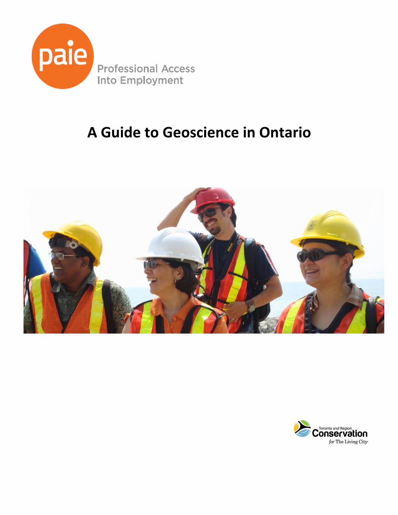
A Guide to Geoscience in Ontario
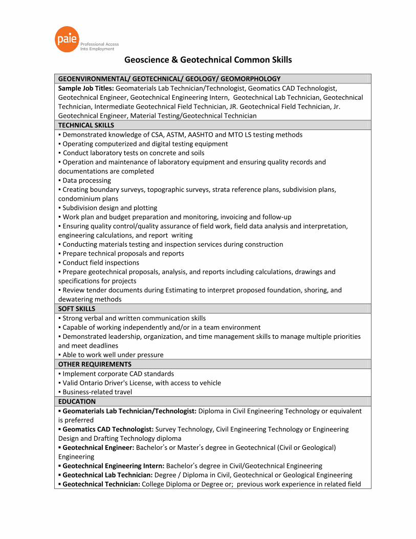
Geoscience & Geotechnical Common Skills
GEOENVIRONMENTAL/ GEOTECHNICAL/ GEOLOGY/ GEOMORPHOLOGY
Sample Job Titles: Geomaterials Lab Technician/Technologist, Geomatics CAD Technologist, Geotechnical Engineer, Geotechnical Engineering Intern, Geotechnical Lab Technician, Geotechnical Technician, Intermediate Geotechnical Field Technician, JR. Geotechnical Field Technician, Jr. Geotechnical Engineer, Material Testing/Geotechnical Technician
TECHNICAL SKILLS
▪ Demonstrated knowledge of CSA, ASTM, AASHTO and MTO LS testing methods ▪ Operating computerized and digital testing equipment ▪ Conduct laboratory tests on concrete and soils ▪ Operation and maintenance of laboratory equipment and ensuring quality records and documentations are completed ▪ Data processing ▪ Creating boundary surveys, topographic surveys, strata reference plans, subdivision plans, condominium plans ▪ Subdivision design and plotting ▪ Work plan and budget preparation and monitoring, invoicing and follow-up ▪ Ensuring quality control/quality assurance of field work, field data analysis and interpretation, engineering calculations, and report writing ▪ Conducting materials testing and inspection services during construction ▪ Prepare technical proposals and reports ▪ Conduct field inspections ▪ Prepare geotechnical proposals, analysis, and reports including calculations, drawings and specifications for projects ▪ Review tender documents during Estimating to interpret proposed foundation, shoring, and dewatering methods
SOFT SKILLS
▪ Strong verbal and written communication skills ▪ Capable of working independently and/or in a team environment ▪ Demonstrated leadership, organization, and time management skills to manage multiple priorities and meet deadlines ▪ Able to work well under pressure
OTHER REQUIREMENTS
▪ Implement corporate CAD standards ▪ Valid Ontario Driver's License, with access to vehicle ▪ Business-related travel
EDUCATION
▪ Geomaterials Lab Technician/Technologist: Diploma in Civil Engineering Technology or equivalent is preferred ▪ Geomatics CAD Technologist: Survey Technology, Civil Engineering Technology or Engineering Design and Drafting Technology diploma ▪ Geotechnical Engineer: Bachelor’s or Master’s degree in Geotechnical (Civil or Geological) Engineering ▪ Geotechnical Engineering Intern: Bachelor’s degree in Civil/Geotechnical Engineering ▪ Geotechnical Lab Technician: Degree / Diploma in Civil, Geotechnical or Geological Engineering ▪ Geotechnical Technician: College Diploma or Degree or; previous work experience in related field
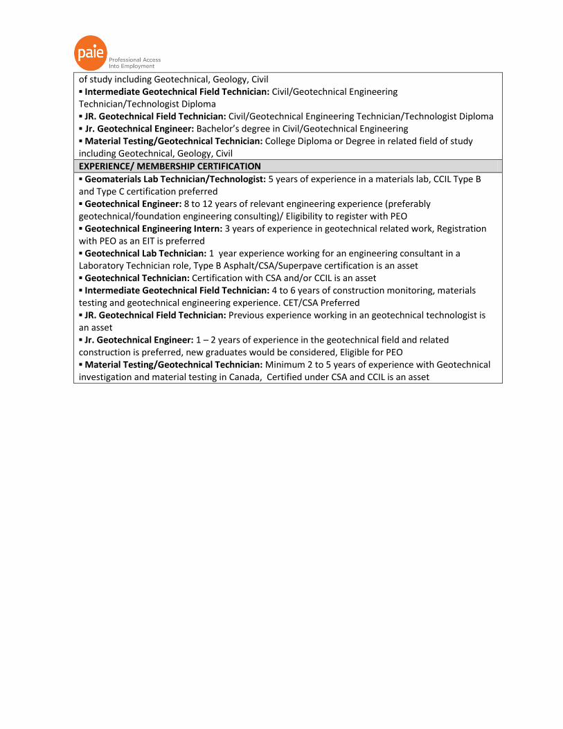
of study including Geotechnical, Geology, Civil ▪ Intermediate Geotechnical Field Technician: Civil/Geotechnical Engineering Technician/Technologist Diploma ▪ JR. Geotechnical Field Technician: Civil/Geotechnical Engineering Technician/Technologist Diploma ▪ Jr. Geotechnical Engineer: Bachelor’s degree in Civil/Geotechnical Engineering ▪ Material Testing/Geotechnical Technician: College Diploma or Degree in related field of study including Geotechnical, Geology, Civil
EXPERIENCE/ MEMBERSHIP CERTIFICATION
▪ Geomaterials Lab Technician/Technologist: 5 years of experience in a materials lab, CCIL Type B and Type C certification preferred ▪ Geotechnical Engineer: 8 to 12 years of relevant engineering experience (preferably geotechnical/foundation engineering consulting)/ Eligibility to register with PEO ▪ Geotechnical Engineering Intern: 3 years of experience in geotechnical related work, Registration with PEO as an EIT is preferred ▪ Geotechnical Lab Technician: 1 year experience working for an engineering consultant in a Laboratory Technician role, Type B Asphalt/CSA/Superpave certification is an asset ▪ Geotechnical Technician: Certification with CSA and/or CCIL is an asset ▪ Intermediate Geotechnical Field Technician: 4 to 6 years of construction monitoring, materials testing and geotechnical engineering experience. CET/CSA Preferred ▪ JR. Geotechnical Field Technician: Previous experience working in an geotechnical technologist is an asset ▪ Jr. Geotechnical Engineer: 1 – 2 years of experience in the geotechnical field and related construction is preferred, new graduates would be considered, Eligible for PEO ▪ Material Testing/Geotechnical Technician: Minimum 2 to 5 years of experience with Geotechnical investigation and material testing in Canada, Certified under CSA and CCIL is an asset

Geoscience & Geotechnical Employers
Employer List
Alston Associates Inc. AMEC Ausenco Engineering Canada Inc. Construction Control Inc. Contestoga- Rovers & Associates DBA Engineering Ltd. Dessau DST Consulting Engineers Inc. EBA Engineering Consultants Ltd. exp Services Inc. Genviar Golder KGS Group Consulting Klohn Crippen Berger LVM Inc. M.R. Wright & Associates Co. Nasiruddin Engineering Ltd. O’ Connor Associates Paterson Group Consulting Patriot Engineering and Environment Peto MacCallum Ltd. Sarafinchin Associates SLR Consultant Stantec Terrapex Env Ltd. Terraprobe Tetra Tech Thurber Engineering Ltd. Virtual Engineers
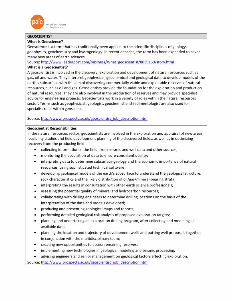
GEOSCIENTIST
What is Geoscience? Geoscience is a term that has traditionally been applied to the scientific disciplines of geology, geophysics, geochemistry and hydrogeology. In recent decades, the term has been expanded to cover many new areas of earth sciences. Source: http://www.leaderpost.com/business/What+geoscientist/8039169/story.html What is a Geoscientist? A geoscientist is involved in the discovery, exploration and development of natural resources such as gas, oil and water. They interpret geophysical, geochemical and geological data to develop models of the earth's subsurface with the aim of discovering commercially viable and exploitable reserves of natural resources, such as oil and gas. Geoscientists provide the foundation for the exploration and production of natural resources. They are also involved in the production of reserves and may provide specialist advice for engineering projects. Geoscientists work in a variety of roles within the natural resources sector. Terms such as geophysicist, geologist, geochemist and sedimentologist are also used for specialist roles within geoscience.
Source: http://www.prospects.ac.uk/geoscientist_job_description.htm
Geoscientist Responsibilities In the natural resources sector, geoscientists are involved in the exploration and appraisal of new areas, feasibility studies and field development planning of the discovered fields, as well as in optimizing recovery from the producing field.
collecting information in the field, from seismic and well data and other sources;
monitoring the acquisition of data to ensure consistent quality;
interpreting data to determine subsurface geology and the economic importance of natural
resources, using sophisticated technical software;
developing geological models of the earth's subsurface to understand the geological structure,
rock characteristics and the likely distribution of oil/gas/mineral-bearing strata;
interpreting the results in consultation with other earth science professionals;
assessing the potential quality of mineral and hydrocarbon resources;
collaborating with drilling engineers to determine drilling locations on the basis of the
interpretation of the data and models developed;
producing and presenting geological maps and reports;
performing detailed geological risk analysis of proposed exploration targets;
planning and undertaking an exploration drilling program, after collecting and modeling all
available data;
planning the location and trajectory of development wells and putting well proposals together
in conjunction with the multidisciplinary team;
creating new opportunities to access remaining reserves;
implementing new technologies in geological modeling and seismic processing;
advising engineers and senior management on geological factors affecting exploration.
Source: http://www.prospects.ac.uk/geoscientist_job_description.htm

GEOTECHNICAL ENGINEERING
What is Geotechnical Engineering? Geotechnical engineering is the study of the behaviour of soils under the influence of loading forces and soil-water interactions. This knowledge is applied to the design of foundations, retaining walls, earth dams, clay liners, and geo-synthetics for waste containment. Source: http://www.mcgill.ca/civil/undergrad/areas/geotechnical Geotechnical engineering is a civil engineering discipline that is concerned with building on, in, or with soil and rock. Source: http://www.ntnu.edu/bat/geotechnics
Applications/ Responsibilities The goals of geotechnical engineers could range from the design of foundations and temporary excavation support, through route selection for railways and highways, to the increasingly important areas of landfill disposal of wastes and groundwater contamination. As such, the geotechnical engineer is involved in field and laboratory investigations to determine the engineering properties of site soils and other geo-materials and their subsequent use in the analytical study of the problem at hand. Source: http://www.mcgill.ca/civil/undergrad/areas/geotechnical Geotechnical engineers design dams, embankments, cuts, foundations, retaining walls, anchors, tunnels, and all other structures directly interacting with the subsoil, both onshore and offshore. Risk assessment associated to geo-hazards such as landslides or earthquakes is another responsibility of geotechnical engineers. Source: http://www.ntnu.edu/bat/geotechnics
Job Opportunities Employment opportunities include geotechnical and engineering consultants, public utilities, governmental agencies, environmental agencies, specialized contractors and resource industry companies. Source: http://www.mcgill.ca/civil/undergrad/areas/geotechnical
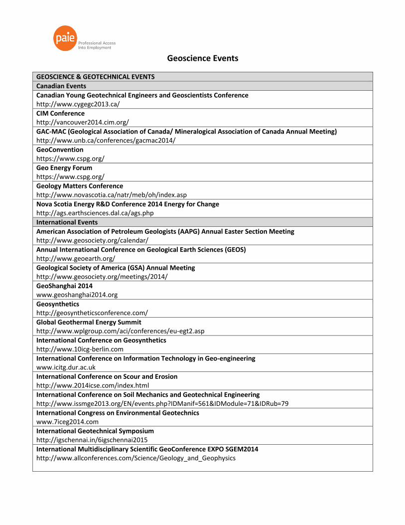
Geoscience Events
GEOSCIENCE & GEOTECHNICAL EVENTS
Canadian Events
Canadian Young Geotechnical Engineers and Geoscientists Conference http://www.cygegc2013.ca/
CIM Conference http://vancouver2014.cim.org/
GAC-MAC (Geological Association of Canada/ Mineralogical Association of Canada Annual Meeting) http://www.unb.ca/conferences/gacmac2014/
GeoConvention https://www.cspg.org/
Geo Energy Forum https://www.cspg.org/
Geology Matters Conference http://www.novascotia.ca/natr/meb/oh/index.asp
Nova Scotia Energy R&D Conference 2014 Energy for Change http://ags.earthsciences.dal.ca/ags.php
International Events
American Association of Petroleum Geologists (AAPG) Annual Easter Section Meeting http://www.geosociety.org/calendar/
Annual International Conference on Geological Earth Sciences (GEOS) http://www.geoearth.org/
Geological Society of America (GSA) Annual Meeting http://www.geosociety.org/meetings/2014/
GeoShanghai 2014 www.geoshanghai2014.org
Geosynthetics http://geosyntheticsconference.com/
Global Geothermal Energy Summit http://www.wplgroup.com/aci/conferences/eu-egt2.asp
International Conference on Geosynthetics http://www.10icg-berlin.com
International Conference on Information Technology in Geo-engineering www.icitg.dur.ac.uk
International Conference on Scour and Erosion http://www.2014icse.com/index.html
International Conference on Soil Mechanics and Geotechnical Engineering http://www.issmge2013.org/EN/events.php?IDManif=561&IDModule=71&IDRub=79
International Congress on Environmental Geotechnics www.7iceg2014.com
International Geotechnical Symposium http://igschennai.in/6igschennai2015
International Multidisciplinary Scientific GeoConference EXPO SGEM2014 http://www.allconferences.com/Science/Geology_and_Geophysics
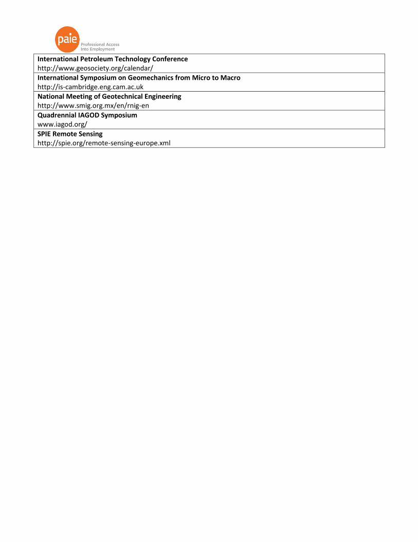
International Petroleum Technology Conference http://www.geosociety.org/calendar/
International Symposium on Geomechanics from Micro to Macro http://is-cambridge.eng.cam.ac.uk
National Meeting of Geotechnical Engineering http://www.smig.org.mx/en/rnig-en
Quadrennial IAGOD Symposium www.iagod.org/
SPIE Remote Sensing http://spie.org/remote-sensing-europe.xml
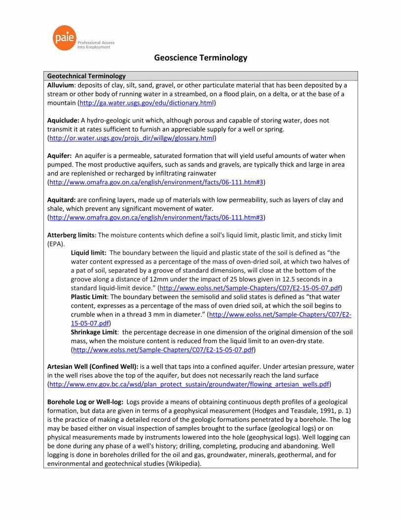
Geoscience Terminology
Geotechnical Terminology
Alluvium: deposits of clay, silt, sand, gravel, or other particulate material that has been deposited by a stream or other body of running water in a streambed, on a flood plain, on a delta, or at the base of a mountain (http://ga.water.usgs.gov/edu/dictionary.html) Aquiclude: A hydro-geologic unit which, although porous and capable of storing water, does not transmit it at rates sufficient to furnish an appreciable supply for a well or spring. (http://or.water.usgs.gov/projs_dir/willgw/glossary.html) Aquifer: An aquifer is a permeable, saturated formation that will yield useful amounts of water when pumped. The most productive aquifers, such as sands and gravels, are typically thick and large in area and are replenished or recharged by infiltrating rainwater (http://www.omafra.gov.on.ca/english/environment/facts/06-111.htm#3) Aquitard: are confining layers, made up of materials with low permeability, such as layers of clay and shale, which prevent any significant movement of water. (http://www.omafra.gov.on.ca/english/environment/facts/06-111.htm#3) Atterberg limits: The moisture contents which define a soil's liquid limit, plastic limit, and sticky limit (EPA).
Liquid limit: The boundary between the liquid and plastic state of the soil is defined as “the water content expressed as a percentage of the mass of oven-dried soil, at which two halves of a pat of soil, separated by a groove of standard dimensions, will close at the bottom of the groove along a distance of 12mm under the impact of 25 blows given in 12.5 seconds in a standard liquid-limit device.” (http://www.eolss.net/Sample-Chapters/C07/E2-15-05-07.pdf) Plastic Limit: The boundary between the semisolid and solid states is defined as “that water content, expresses as a percentage of the mass of oven dried soil, at which the soil begins to crumble when in a thread 3 mm in diameter.” (http://www.eolss.net/Sample-Chapters/C07/E2-15-05-07.pdf) Shrinkage Limit: the percentage decrease in one dimension of the original dimension of the soil mass, when the moisture content is reduced from the liquid limit to an oven-dry state. (http://www.eolss.net/Sample-Chapters/C07/E2-15-05-07.pdf)
Artesian Well (Confined Well): is a well that taps into a confined aquifer. Under artesian pressure, water in the well rises above the top of the aquifer, but does not necessarily reach the land surface (http://www.env.gov.bc.ca/wsd/plan_protect_sustain/groundwater/flowing_artesian_wells.pdf) Borehole Log or Well-log: Logs provide a means of obtaining continuous depth profiles of a geological formation, but data are given in terms of a geophysical measurement (Hodges and Teasdale, 1991, p. 1) is the practice of making a detailed record of the geologic formations penetrated by a borehole. The log may be based either on visual inspection of samples brought to the surface (geological logs) or on physical measurements made by instruments lowered into the hole (geophysical logs). Well logging can be done during any phase of a well's history; drilling, completing, producing and abandoning. Well logging is done in boreholes drilled for the oil and gas, groundwater, minerals, geothermal, and for environmental and geotechnical studies (Wikipedia).

Boreholes: Any exploratory hole drilled into the Earth or ice to gather geophysical data (EPA). Casing: is large-diameter pipe lowered into an open hole and cemented in place. The well designer must design casing to withstand a variety of forces, such as collapse, burst, and tensile failure, as well as chemically aggressive brines. (http://www.glossary.oilfield.slb.com/Display.cfm?Term=casing) The pipe material placed inside a drilled hole to prevent the hole from collapsing. The two types of casing in most injection wells are surface casing, the outer most casing that extends from the surface to the base of the lowermost USDW, and long-string casing, which extends from the surface to or through the injection zone (EPA) Cofferdam: A coffer dam is a temporary structure built into a waterway to contain or divert movement of water and to provide a reasonably dry construction area. Coffer dams are commonly made of steel sheet pile, rock, gabions, concrete jersey barriers, vinyl tubes filled with water, or wood and may be lined with geotextile, plastic sheeting, or other materials to prevent water from entering the construction area. (http://www.itd.idaho.gov/manuals/Online_Manuals/BMP/) Dewatering: Removing water from a system. For instance removing water from a stream or aquifer for use in a quarry. (http://www.bgs.ac.uk/planning4minerals/glossary.htm#dewatering) Ontario EA Process: Environmental Assessment: Environmental assessments are prepared for large-scale, complex projects that have the potential for significant environmental effects and require a ministry approval. (http://www.ene.gov.on.ca/environment/en/industry/assessment_and_approvals/environmental_assessments/STDPROD_075715)
The Steps of Ontario EA: (http://www.ene.gov.on.ca/environment/en/industry/assessment_and_approvals/environmental_assessments/STDPROD_075715)
1. Submission of the Terms of References (ToR): The proponent must submit a document explaining the purpose and need of the undertaking. Consultation with the public must be documented.
2. EA preparation: After the ToR is approved, the proponent will need to produce an environmental assessment. The EA must include the development plan and the decision making process. In addition, the EA will identify and evaluate alternatives to the undertaking, the environmental effects, impacts mitigation and management measures. Finally, a record of consultation must be included with the EA. Therefore, consultation with the public, Aboriginal communities and government agencies must occur.
3. EA submission: the proponent submits the EA along with the EA summary form to the Ministry of the Environment for a review.
4. Public Review: the public, Aboriginal communities and other parties and experts are encouraged to review and comment on the EA. The proponent is allowed to include any changes to the EA.
5. Ministry Review: The ministry takes the comments from the public, the revisions by the proponent and produces the Ministry Review document. The document also includes a discussion of how the proponent is in compliance with the ToR and the EA Act.
6. Public Review: the public, Aboriginal communities and other interested parties are than

encouraged to provide comments to the Ministry Review to the MOE. 7. Minister’s decision: The Minister and Cabinet review the EA and select one of the following 3
options: Refer the process to mediation, refer the process to the Environmental Review Tribunal or Make a decision. The final option has 3 more options: approve the EA, approve the EA with conditions or refuse the EA.
8. Project implementation: Once the EA is approved, the proponent must obtain any other permits or approvals required under other Ontario legislation. The project proponent must demonstrate how they have fulfilled their commitments in the EA during construction.
All projects do not have to go through this EA process. Some may be more suited for a Streamlined EA if the project impacts are known and understood. Furthermore, some projects may only be subjected to certain parts of the EA Act, or voluntary measures may be imposed. Erosion Control Measures (ie. planting, re-vegetation, geotextile membranes, etc): (http://www.trca.on.ca/dotAsset/83077.pdf) Erosion: The wearing away of soil by wind and water. Erosion occurs naturally from weather or runoff, but land-clearing practices related to farming, residential or industrial development, road building, mining, or timber cutting can intensify the runoff (Idaho Transportation Department). Berm: A raised and elongated area of earth or rock for erosion control intended to divert or direct the flow of water(Idaho Transportation Department).
Riprap: Durable, angular field or quarry stones of approved quality, sound, hard, free from seams and other structural defects that are placed for protection against the erosive action of water or wind (Idaho Transportation Department). Faults: are displacements along fractures that cut the rock (Bowman). Fill: Man-made deposits of natural soils or rock products and waste materials (EPA) Geotechnical Reports: is required to confirm that the land may be used safely for the intended use without undue risk of hazards or damage to the environment. (http://www.crd.bc.ca/buildinginspection/documents/GuidelinesforthePreparationofGeotechnicalReports.pdf) Groundwater: 1) water that flows or seeps downward and saturates soil or rock, supplying springs and wells. The upper surface of the saturate zone is called the water table. (2) Water stored underground in rock crevices and in the pores of geologic materials that make up the Earth's crust. (http://ga.water.usgs.gov/edu/dictionary.html) Hydrogeological Investigations (process) \\Downsview01\data\Home\Public\Diversity Projects\PAIE Program\Curriculum Development\Resource Guides, Targeting & Supplementary\Resource & Networking Guides\AR's Files\4_Terminology\State of Michigan_General Guidelines for Hydrogeological Investigations.pdf
Leaching: The percolation of nutrients and other compounds such as salt within the top layers of soil into subsoil layers and ground-water zones (http://el.erdc.usace.army.mil/dots/budm/glossary.cfm)

Slope Protection: http://www.ipcbee.com/vol13/36-R017.pdf http://ottawa.ca/cs/groups/content/@webottawa/documents/pdf/mdaw/mtm4/~edisp/cap137604.pdf Bio-engineering : Restoration or reinforcement of slopes and stream banks with living plant materials. (Idaho Transportation Department, 2008, p. 111) Soil Compaction (static load, impacting force, vibration): the process of bringing soil to a dense state by blows, by passage of a roller, or by some other type of loading. (http://www.eolss.net/Sample-Chapters/C07/E2-15-05-07.pdf) Soil Properties & Characteristics (clay, sand, etc) SOIL SEPARATES: A Natural Resource Conservation Service classification of mineral particles less than 2 millimeters in equivalent diameter and ranging between specified size limits. The names and sizes of separates recognized in the United States are as follows: very coarse sand (2.0 to 1.0 millimeter); coarse sand (1.0 to 0.5 millimeter); medium sand (0.5 to 0.25 millimeter); fine sand (0.25 to 0.10 millimeter); very fine sand (0.10 to 0.05 millimeter); silt (0.005 to 0.002 millimeter); and clay (less than 0.02 millimeter) (Idaho Transportation Department). Clay : Soil particle having a grain size of less than 2 micrometers (http://el.erdc.usace.army.mil/dots/budm/glossary.cfm) Sand: That fraction of soil or dredged material whose grain size distribution is 2.00 to 0.05 mm, generally referred to as coarse-grained. micrometers. (http://el.erdc.usace.army.mil/dots/budm/glossary.cfm) Silt: The fraction of soil or dredged material whose grain size distribution is 0.05 to 0.002 mm, generally referred to as fine grained. (http://el.erdc.usace.army.mil/dots/budm/glossary.cfm) Gravel: A loose mixture of pebbles and rock fragments coarser than sand, often mixed with clay (http://el.erdc.usace.army.mil/dots/budm/glossary.cfm) Standard Penetration Test: The Standard Penetration Test SPT is performed from the base of a bore-hoIe where a drop weight of certain mass and falling distance drives a standardized cone into the soil. The number of blows required tor a certain penetration depth is being recorded. (http://www.nordmeyer.nl/membersonly/SPT%20english.pdf)
Standard Proctor Maximum Dry Density (SPMDDT) (Proctor Compaction Test): a lab procedure designed to bring soils to approximately the same state of density that is obtained when earth dams are compacted by means of rolling equipment. (http://www.eolss.net/Sample-Chapters/C07/E2-15-05-07.pdf)) Topographic Survey: determining the relative locations of points (places) on the earth's surface by measuring horizontal distances, differences in elevation and directions. (http://uregina.ca/~sauchyn/geog411/topographic_surveying.html) Trench Boxes: A pre-constructed set of side plates and adjustable cross members to prevent the walls of the pit from collapsing. (http://www.nastt.org/glossary/T?page=1)
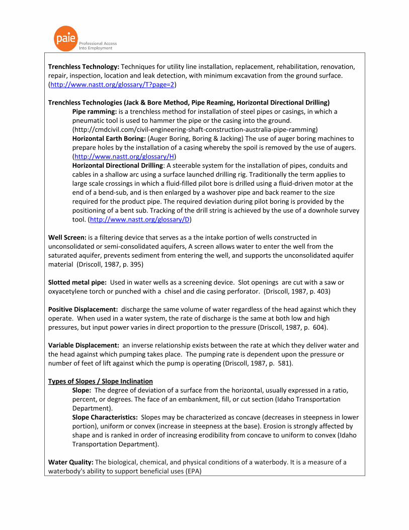
Trenchless Technology: Techniques for utility line installation, replacement, rehabilitation, renovation, repair, inspection, location and leak detection, with minimum excavation from the ground surface. (http://www.nastt.org/glossary/T?page=2) Trenchless Technologies (Jack & Bore Method, Pipe Reaming, Horizontal Directional Drilling)
Pipe ramming: is a trenchless method for installation of steel pipes or casings, in which a pneumatic tool is used to hammer the pipe or the casing into the ground. (http://cmdcivil.com/civil-engineering-shaft-construction-australia-pipe-ramming) Horizontal Earth Boring: (Auger Boring, Boring & Jacking) The use of auger boring machines to prepare holes by the installation of a casing whereby the spoil is removed by the use of augers. (http://www.nastt.org/glossary/H) Horizontal Directional Drilling: A steerable system for the installation of pipes, conduits and cables in a shallow arc using a surface launched drilling rig. Traditionally the term applies to large scale crossings in which a fluid-filled pilot bore is drilled using a fluid-driven motor at the end of a bend-sub, and is then enlarged by a washover pipe and back reamer to the size required for the product pipe. The required deviation during pilot boring is provided by the positioning of a bent sub. Tracking of the drill string is achieved by the use of a downhole survey tool. (http://www.nastt.org/glossary/D)
Well Screen: is a filtering device that serves as a the intake portion of wells constructed in unconsolidated or semi-consolidated aquifers, A screen allows water to enter the well from the saturated aquifer, prevents sediment from entering the well, and supports the unconsolidated aquifer material (Driscoll, 1987, p. 395) Slotted metal pipe: Used in water wells as a screening device. Slot openings are cut with a saw or oxyacetylene torch or punched with a chisel and die casing perforator. (Driscoll, 1987, p. 403) Positive Displacement: discharge the same volume of water regardless of the head against which they operate. When used in a water system, the rate of discharge is the same at both low and high pressures, but input power varies in direct proportion to the pressure (Driscoll, 1987, p. 604).
Variable Displacement: an inverse relationship exists between the rate at which they deliver water and the head against which pumping takes place. The pumping rate is dependent upon the pressure or number of feet of lift against which the pump is operating (Driscoll, 1987, p. 581).
Types of Slopes / Slope Inclination
Slope: The degree of deviation of a surface from the horizontal, usually expressed in a ratio, percent, or degrees. The face of an embankment, fill, or cut section (Idaho Transportation Department). Slope Characteristics: Slopes may be characterized as concave (decreases in steepness in lower portion), uniform or convex (increase in steepness at the base). Erosion is strongly affected by shape and is ranked in order of increasing erodibility from concave to uniform to convex (Idaho Transportation Department).
Water Quality: The biological, chemical, and physical conditions of a waterbody. It is a measure of a waterbody's ability to support beneficial uses (EPA)
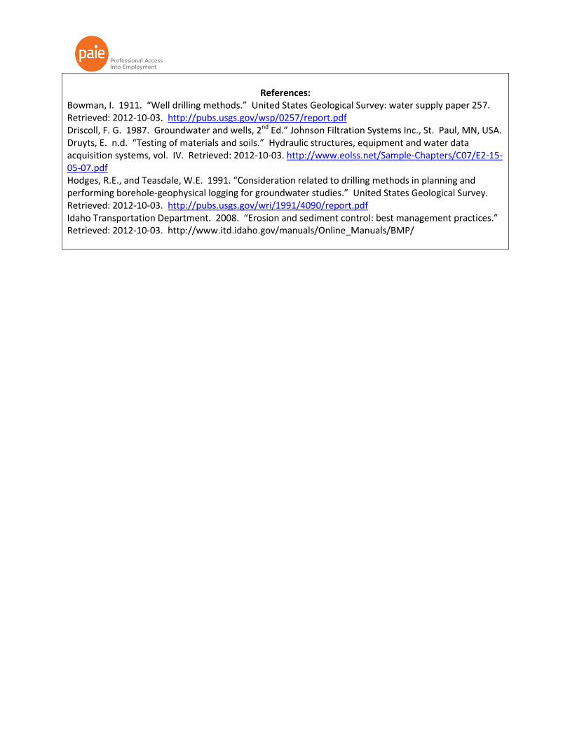
References:
Bowman, I. 1911. “Well drilling methods.” United States Geological Survey: water supply paper 257. Retrieved: 2012-10-03. http://pubs.usgs.gov/wsp/0257/report.pdf Driscoll, F. G. 1987. Groundwater and wells, 2nd Ed.” Johnson Filtration Systems Inc., St. Paul, MN, USA. Druyts, E. n.d. “Testing of materials and soils.” Hydraulic structures, equipment and water data acquisition systems, vol. IV. Retrieved: 2012-10-03. http://www.eolss.net/Sample-Chapters/C07/E2-15-05-07.pdf Hodges, R.E., and Teasdale, W.E. 1991. “Consideration related to drilling methods in planning and performing borehole-geophysical logging for groundwater studies.” United States Geological Survey. Retrieved: 2012-10-03. http://pubs.usgs.gov/wri/1991/4090/report.pdf Idaho Transportation Department. 2008. “Erosion and sediment control: best management practices.” Retrieved: 2012-10-03. http://www.itd.idaho.gov/manuals/Online_Manuals/BMP/

Geoscience Publications
Geoenvironmental / Geotechnical / Geology Publications
Acta Geotechnica Canadian Geotechnical Journal CATENA Electronic Journal of Geotechnical Engineering Engineering Geology Environmental and Engineering Geoscience Geological Abstracts Geomaterials Geomechanics Abstracts Geomechanics and Engineering Geomechanics and Geoengineering Geomorphology Georisk Geosynthetics International Geotechnical News Geotechnical Testing Journal Geotechnique Geotextiles and Geomembranes IEEE Geoscience and Remote Sensing Letters International Journal for Numerical and Analytical Methods in Geomechanics International Journal of Geotechnical Earthquake Engineering International Journal of Geotechnical Engineering International Journal of Mineral Processing International Journal of Mining Science and Technology International Journal of Rock Mechanics and Mining Sciences Journal of GeoEngineering Journal of Geophysics and Engineering Journal of Geotechnical and Geoenvironmental Engineering Journal of Mining and Metallurgy Journal of Mining Science Journal of Rock Mechanics and Geotechnical Engineering Journal of Terramechanics Minerals Engineering Quarterly Journal of Engineering Geology and Hydrogeology Rock Mechanics and Rock Engineering Soil Dynamics and Earthquake Engineering Soils and Rocks

Geoscience Social Media Pages
SOCIAL MEDIA
Geoenvironmental / Geotechnical / Geology / Geomorphology
LinkedIn Groups AAPG/Division of Environmental Geosciences Brownfield Redevelopment Canadian Environmental Compliance Contaminated Land Management e3Plus – PDAC Earth Science Engineering Geologists Environmental Geologists/Hydrogeologists Environmental Health & Safety Professionals (10,000 members+) Environmental Impact Assessment Exploration Geologist Geologist Network Geology Professionals Geomorphology Geo-Professionals Geotechnical Engineering Experts GIS in the Geosciences Professionals Linked:Energy (Energy industry expertise) Ontario Geological Survey [M] Petroleum Explorationists / Geologists / Geophysicists Professionals in Environmental Risk Assessment Quaternary Geology & Geomorphology Remediation Technology Resource Group River Restoration Professionals Sediment Remediation Sedimentary Geology SEPM (Society for Sedimentary Geology) Stream Restoration Professionals The Geological Society of America Women in Mining
Twitter @SoilScience @SSSA_soils @USGS @geologynews @GetGeologyJobs @geolsoc @Fielders @GeologyReport @GeologyDotCom @coalgeology
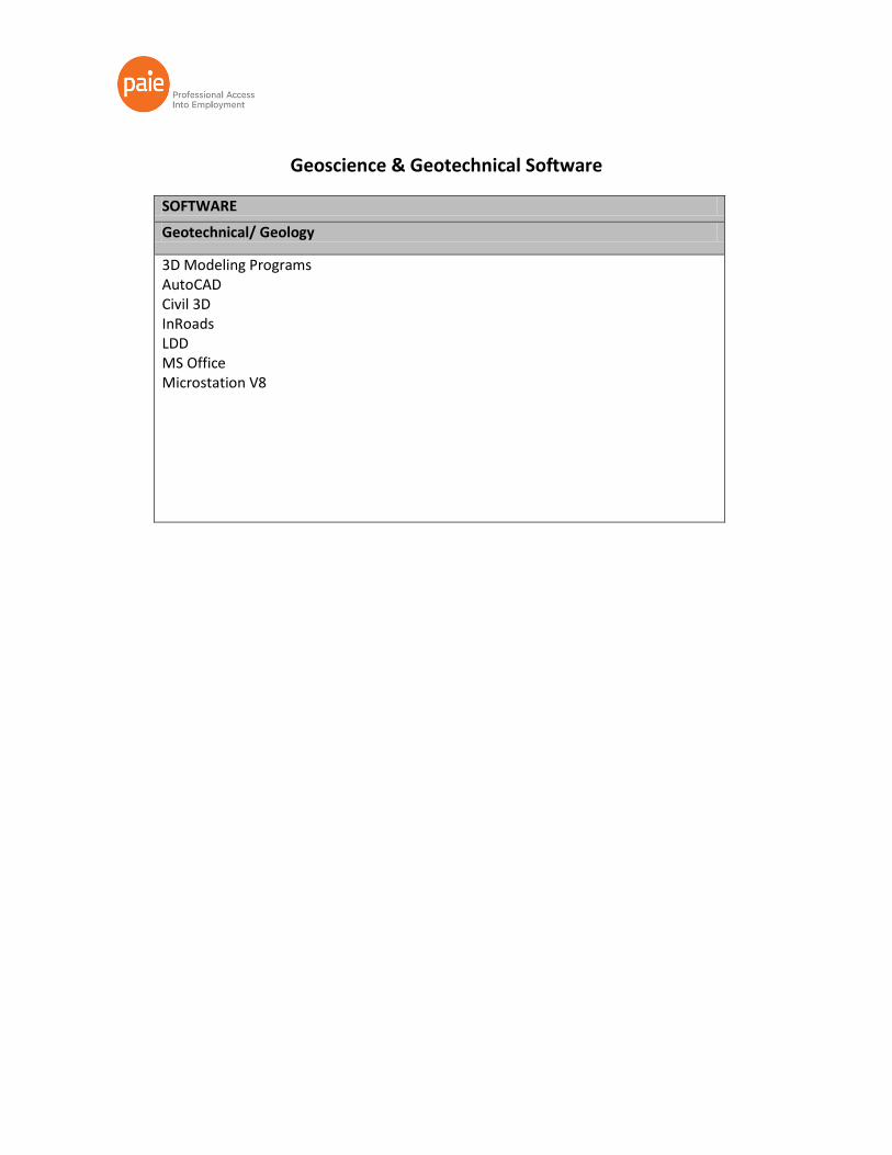
Geoscience & Geotechnical Software
SOFTWARE
Geotechnical/ Geology
3D Modeling Programs AutoCAD Civil 3D InRoads LDD MS Office Microstation V8
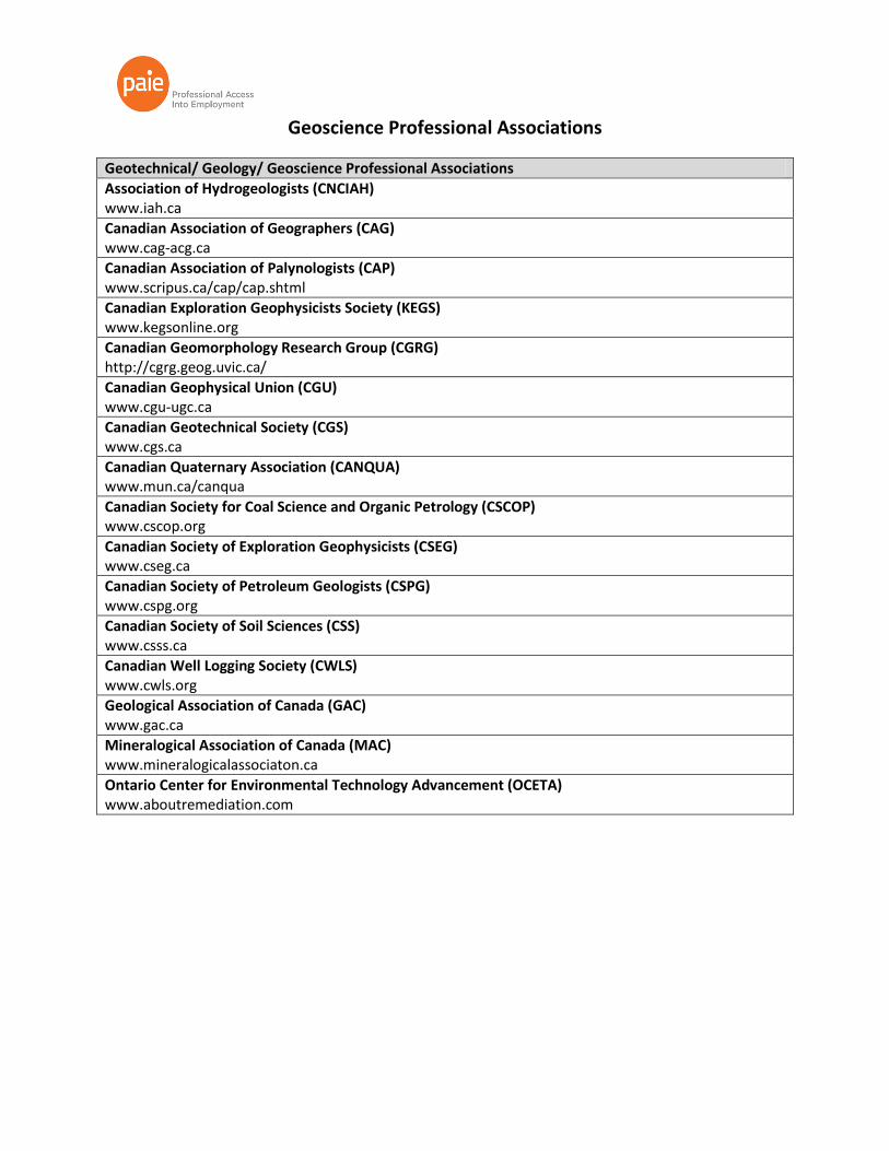
Geoscience Professional Associations
Geotechnical/ Geology/ Geoscience Professional Associations
Association of Hydrogeologists (CNCIAH) www.iah.ca
Canadian Association of Geographers (CAG) www.cag-acg.ca
Canadian Association of Palynologists (CAP) www.scripus.ca/cap/cap.shtml
Canadian Exploration Geophysicists Society (KEGS) www.kegsonline.org
Canadian Geomorphology Research Group (CGRG) http://cgrg.geog.uvic.ca/
Canadian Geophysical Union (CGU) www.cgu-ugc.ca
Canadian Geotechnical Society (CGS) www.cgs.ca
Canadian Quaternary Association (CANQUA) www.mun.ca/canqua
Canadian Society for Coal Science and Organic Petrology (CSCOP) www.cscop.org
Canadian Society of Exploration Geophysicists (CSEG) www.cseg.ca
Canadian Society of Petroleum Geologists (CSPG) www.cspg.org
Canadian Society of Soil Sciences (CSS) www.csss.ca
Canadian Well Logging Society (CWLS) www.cwls.org
Geological Association of Canada (GAC) www.gac.ca
Mineralogical Association of Canada (MAC) www.mineralogicalassociaton.ca
Ontario Center for Environmental Technology Advancement (OCETA) www.aboutremediation.com