Embed Size (px)
Citation preview

Afr. J . Ecol. 1989, Volume 27, pages 7-21
A peat fire in the Okavango Delta, Botswana, and its importance as an ecosystem process
W . N . ELLERY*, K. ELLERY*, T . S . M c C A R T H Y f , B . CAIRNCROSSf a n d R. OELOFSES Departmentsof *Botanyand tGeology, University of the Witwatersrand, PO Wits, Johannesburg 20.50; and $Anglo American Corporation of S.A., PO Box 61.587, Marshalltown 2107, Johannesburg, RSA
Summary The progressive abandonment and desiccation of the lower Nqoga River system and its associated vegetation-covered peat deposits, has resulted in the develop- ment of subsurface peat fires. These appear to have been burning within the study area for decades and consist of a mosaic of burning fronts, the first of which burns to a depth of up to 15 cm. This relatively shallow fire destroys the bases of stems and plant rhizomes, thereby preventing re-establishment of the former plant community by vegetative growth. Deeper fires are initiated where cracks develop in the peat during drying and desiccation. The depths to which these burn are limited by peat moisture content or by the presence of an incombustible inorganic sub- strate. The initial collapse is some 30-40 vol. %. Further compaction is brought about by rainfall and animal trampling which may cause volume reductions of as much as 98%.
The short-term consequences of subsurface peat fires include the release of plant nutrients, enhancement of soil texture and soil water retention properties, and temporary transformation of the area into a terrestrial habitat. However, physiographic changes induced by the peat fire result in its eventual reflooding. It is proposed that the time delay between burning and reflooding, and the rate and depth of reflooding, determine the nature of the habitats which form after re-inundation. These processes are important in maintaining the overall structure and functioning of the Okavango Delta ecosystem.
RCsumC L’abandon progressif et le dessichement de la basse Nqoga et des dep6ts de tourbe qui y sont associks ont abouti au dkveloppement de feux de tourbe sous la surface. I1 semble que ceux-ci brdlaient depuis des dkcennies a I’endroit des recherches et qu’ils se composent d’une mosaique de petits feux dont le premier briile jusqu’a une profondeur de 15cm. Ce feu assez superficiel detruit les bases des tiges et les rhizomes des plantes, empichant de ce fait le rktablissement de la plante originelle par simple croissance vegetative. Des feux plus profonds surviennent lorsque des fissures se dkveloppent dans la tourbe en voie de dessication. La profondeur a laquelle ils briilent est limitte par I’humiditk de la tourbe ou par la prksence d’un substrat inorganique incombustible. L’effondrement initial correspond A quelque 30 a 40% en volume. Les chutes de pluies et le pietinement des animaux peuvent
7

8 W. N. Ellery et al.
tasser encore plus et causer des rtductions de volume atteignant 98%. Les consequences a court terme des feux de tourbe souterrains comprennent la libtration de nutriments vkgktaux, une amelioration de la texture du sol et de ses proprittks de rktention d’eau, et la transformation temporaire de la rkgion en un habitat terrestre. Cependant les modifications physiographiques induites par les feux de tourbe rtsultent ultkrieurement en de nouvelles inodations. On pense que le dklai entre le feu et l’inondation ainsi que l’importance et la prondeur de l’inondation dkterminent la nature des habitats qui se forment aprks inondation. Ces processus sont importants pour le maintien de la structure gknkrale et du fonctionnement de l’kcosysttime du Delta de I’Okavango.
Introduction Fire has been recognized as an important ecosystem process in many of the major wetlands of the world. Two types of fire are common. Surface fires affect only the aerially exposed plant parts, while the more severe subsurface peat fires lead to the destruction of above- and below- ground plant organs. In the case of the former, the plant communities are rapidly re-established vegetatively from the undamaged rooting parts while in the latter, destruction of the above- and below-ground organs is complete and the character of the plant communities and even the environment is radically modified (Cypert, 1961; Tallis, 1983; Mar, 1984).
Recognition of the importance of subsurface peat fires in wetland ecosystems has arisen partly from the study of peat cores taken in various wetland areas, particularly in the United States. In such cores, layers of charcoal bear testimony to periods of peat burning. Differences in the character of the charcoal in the peat allows a distinction to be made between that produced by surface fires and that produced by peat fires (Cohen et al., 1987). Extensive charcoal layers in peats from the Okefenokee Swamp (Georgia) have been identified by Cohen (1974), indicating a history of peat burning. Similar layers (termed ‘fire splays’) have been recorded in the peats of the Snuggedy Swamp (South Carolina) by Staub & Cohen (1979), while Craighead, quoted in Hamilton (1984) refers to similar subsurface indications of peat fires in the Everglades (Florida). Despite these references to subsurface peat fires, they have seldom been observed, and as far as is known, have never been described in detail.
The consequences of peat fires in the Okefenokee Swamps have been examined by Cypert (1961). Many of the lakes in this swamp are in fact ‘holes in the peat’ rather than a reflection of subsurface topography. This has been ascribed to the destruction of the peat by fire (Cypert, 1961). It was suggested that subsequent plant succession in these water bodies led to the formation of prairies. The occurrence of ponds in the Snuggedy Swamp has similarly been ascribed to peat fires (Staub 8z Cohen, 1979).
Burning of peat leads to a release of contained minerals which are available for use by subsequent generations of plants (Tallis, 1983). This principle has been used as an agricultural practice in the San Joaquim-Sacremento River ‘Delta’ area of California, where shallow burning of peat was regularly undertaken to improve potato crop yields (Weir, 1950).
We have had the opportunity to examine a peat fire in progress in a remote and fairly inaccessible part of one of Africa’s largest wetlands, the Okavango Delta.

Peatfire in the Okavango Delta 9
190s
200s
22’E 23.OE 24’E
- A\N\\\\\\
MainThaoge - blockage 1
NOoqo Xoenqo
- 190s
Fig. 1. Map of the Okavango Delta.
The fire was discovered quite by chance, and we were thus not equipped to do detailed measurements on the fire itself. This study forms part of a broader investi- gation of the determinants of channel changes, and is, necessarily, based on a knowledge of other aspects of the ecosystem structure and functioning. In this paper we place on record our observations and indicate the possible importance of peat fires to the dynamics of the ecosystem as a whole.
The Study area The Okavango Delta The Okavango Delta situated in northern Botswana, forms part of the large, internal, semi-arid drainage region known as the Kalahari Basin. In the upper reaches of the Delta, the Okavango River is confined in a narrow, linear depression known as the ‘pan-handle’ (Fig. I), but at Seronga it disperses into a number of distributaries resembling a classic ‘birds-foot’ delta, but which is in fact, a large, conical alluvial fan with average gradients of about 1:3600 (Wilson & Dincer, 1976).
10 W. N . Ellery et al.
Seasonal flood waters cannot be accommodated in the distributary channel systems and there is considerable overspill, forming perennial swamps in the upper delta and seasonal swamps in the lower delta (Fig. 1). Water loss is high and hydrological models suggest that some 95% of the seasonal floodwater is lost by evapotranspiration in the Delta.
The peat deposits are restricted to the perennial swamps where emergent plant communities are dominated almost exclusively by Cyperus papyrus L. and Miscanthus junceum (Stapf.) Stapf. Peat accumulation occurs right up to channel margins and the channel banks themselves are composed of vegetatively stabilized peat (McCarthy et al., 1988).
Surface fires, which remove a large proportion of the above-ground plant biomass, burn up to 75 per cent of the area of the Delta each year (Patterson, 1976), particularly in the winter months from June to September. These fires are extensive and in windy conditions may cover tens of square kilometres and can even jump across channels as wide as 20m. The dead plant parts ignite first and provide sufficient heat to enable the combustion of all the emergent plant organs which burn vigorously. Following a fire, however, these communities are able to re-establish rapidly by vegetative growth from submerged plant organs.
Sediments brought into the Delta by the Okavango River consist predomi- nantly of fine bed-load sand and the proportion of suspended load is apparently small (Wilson & Dincer, 1976). The bed-load cannot escape from the peat-lined channels during down-channel sediment movement and accordingly aggradation of channel systems occurs (McCarthy et al., 1986) leading ultimately to a decline in down-channel hydraulic gradients. Vegetation blockages ensue as an increasing proportion of water is lost from the channels into the flanking swamps. Erosion of alternative water courses through the peat eventually leads to channel avulsion (McCarthy et al., 1986). This is accompanied by progressive desiccation of the abandoned river course, coincident with progressive inundation of the newly formed river system.
The lower Nqoga River system
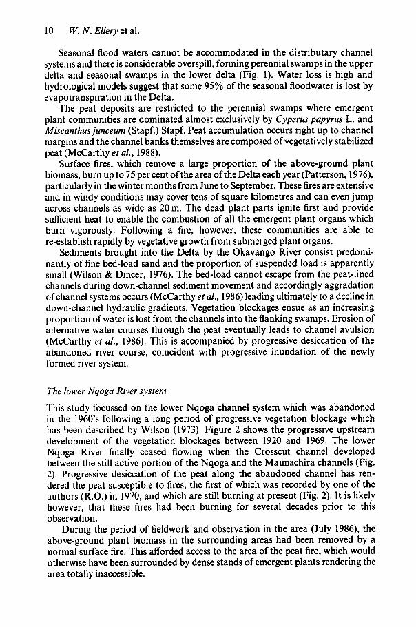
This study focussed on the lower Nqoga channel system which was abandoned in the 1960’s following a long period of progressive vegetation blockage which has been described by Wilson (1973). Figure 2 shows the progressive upstream development of the vegetation blockages between 1920 and 1969. The lower Nqoga River finally ceased flowing when the Crosscut channel developed between the still active portion of the Nqoga and the Maunachira channels (Fig. 2). Progressive desiccation of the peat along the abandoned channel has ren- dered the peat susceptible to fires, the first of which was recorded by one of the authors (R.O.) in 1970, and which are still burning at present (Fig. 2). It is likely however, that these fires had been burning for several decades prior to this observation.
During the period of fieldwork and observation in the area (July 1986), the above-ground plant biomass in the surrounding areas had been removed by a normal surface fire. This afforded access to the area of the peat fire, which would otherwise have been surrounded by dense stands of emergent plants rendering the area totally inaccessible.

Peat j re in the Okavango Delta 11
Area of
Maunochim lediba
i- Approximate limit i. of peranneal water
Fig. 2. Detail ofa portion of the northeastern perennial swamps, showing the progressive development of the Nqoga blockage (Modified from Wilson, 1973).
Methods Survey of active channels The dimensions (width and depth) of the presently active lower Nqoga River, as well as the Maunachira River, were measured in a stratified manner (n= 16). The elevation of the channel bed in relation to the elevation of the surrounding substratum sands was measured at each of these sites. A metal pole was inserted through the peat deposits flanking the channel until further penetration was prevented by the presence of underlying sand.
Survey of abandoned channel area The width and elevation of the abandoned channel bed were measured in relation to the surrounding plains using a dumpy level and staff in an area where the peat flanking the channel had been virtually destroyed as a consequence of peat fires (Site C , Fig. 2). In conjunction with this survey, a number of subsurface profiles (n = 6) were examined at right angles to the channel axis, starting in the thalweg of the former channel. These profiles were surveyed to accurately reflect the relative elevations of various strata.
Long-range channel gradient survey Following channel abandonment and the destruction of peat by fire, the former river course is clearly visible as a linear series of sand bars and scour pools
12 W. N . Ellery et al.
surrounded by a flat and featureless plain (McCarthy et al., 1987). The gradients of the peat substratum, channel bed and water table of the upper reaches of the abandoned channel were measured by one of the authors (R.O.) in 1970 (transect A-C; Fig. 2). This was achieved by measuring the elevation of a temporary survey station on Letenetso Island relative to a station on an island midway along the abandoned channel using simultaneous reciprocal levelling. This method was used to overcome the effects of near-ground thermal refraction. The distance between the two stations was determined using a telurometer. Elevations along the abandoned section itself were surveyed using a dumpy level and staff.
Chemical composition and density of peat and peat ash Samples of peat were collected from each profile examined in the survey of the abandoned channel area. These were subsequently ashed and the concentrations of various mineral constituents were determined by X-ray fluorescence spectrometry (Norrish & Hutton, 1969).
The bulk density of ash samples collected in the field and which had been compacted by rainfall and animal trampling was determined by measuring the volume of water displaced by a wax-coated sample of known weight. The bulk density of peat extracted from a permanently inundated area, using a peat corer which prevents compaction, was determined by measuring the mass of an oven- dried sample (80°C for 48 h) of known volume. The volume was determined by removing a section of core of known length from the corer of known internal diameter. The peat samples (n = 3) used in the determination of bulk density were collected on the Maunachira River near Maunachira Lediba (Fig. 2).
The extent of collapse of peat after burning was estimated by measuring the ash content of the peat samples used in the determination of peat bulk density (n = 3). These were ignited at 450°C in a muffle furnace, and the ash content was deter- mined by mass reduction. The volume of compacted ash of known mass was assumed to be directly related to the bulk density of the compacted ash determined separately as described above.
Investigation of the peatJire itself At the time of the study the peat fire was active approximately 2 km east of the uppermost limit of the Nqoga Blockage (Site B; Fig. 2). The area was visited on three separate occasions within a week. Detailed observations were made on the nature of the fire itself, sites at which it appeared to be initiated, and the nature of the ash which is produced as a consequence of burning to various depths. In the context of the studies on active channels, the burned out section of the abandoned channel, and the composition and density of peat and peat ash, the significance of the peat fire as an ecosystem process over a short time period (years to decades) has been inferred. The consequences of subsurface peat fires over longer time periods (decades to centuries) is evident based on larger scale studies of plant succession in areas other than that affected by the present peat fire (Ellery, 1987).
Results and discussion Description of a section of the active lower Nqoga channel The presently active region of the lower Nqoga River is characteristically between 3 and 4 m deep, and has a width of between 12 and 20 m. A typical cross-section is

PeatJire in the Okavango Delta 13
Fig. 3. Cross section ofa portion ofthe active lower Nqoga River in the region ofHamoga island, showing the distribution of sand and peat.
illustrated in Fig. 3. The depth to the sand beneath the peat deposits flanking the channel is similar to that of the channel.
Although rapid water movement is largely confined to in-channel areas by vegetated peat banks, large quantities of water move into the surrounding swamps by seepage through the peat as well as by overspill through the emergent vegetation (McCarthy et al., 1988). This is in contrast to the movement of bed-load sediments which are confined entirely to in-channel areas by the vegetated peat banks flank- ing the channel. The deposition of bed-load sediments along the channel floor is considered to contribute to channel avulsion (McCarthy et al., 1986). Despite evidence of channel bed aggradation along the lower reaches of the Nqoga River, however (McCarthy et al., 1986), the channel bed is not raised above the level of the surrounding substratum sands. This appears to be due to erosional processes which characterise channel initiation, and which result in the incision of the channel into the pre-channel substratum.
Description of the abandoned area previously burned in subsurface peatJires The sands of the pre-channel substratum within the area of the lower Nqoga river south of Jerejere Lediba (site C; Fig. 2) were grey-black in colour, and easily distinguished from the channel sands themselves which were a clean golden-white colour (Fig. 4). In areas flanking the former channel the ash remains of former peat deposits overlie a thin layer of peat, which, in turn, overlies the pre-channel sands. The former channel bed is raised approximately lm above the level of the surrounding pre-channel substratum sands. Prior to abandonment, and as in the case of the active region of the lower Nqoga River, the peat deposits must have confined rapid water movement as well as bed-load sediment deposition to within channel areas.

14 W. N. Elleryet al,
Position of former channel
- - 3 m
s g - - 4
B x %
p
c
c = c 0 - .- c
- - 5
- -6
,... Mired rand ond corbonocoour motorio I
m c l o a n sono
Pro-channel 8ub8trOtUm :. :I \ :'I
Fig. 4. A surface elevation profile across the abandoned lower Nqoga channel south of Jerejere lediba (Site C; Fig. 2), showing the distribution of pits in which subsurface profiles were examined, and illustrating the probable distribution of the former peat deposits.
The inverted topography which was observed in the region of the abandoned section of the Nqoga River (Fig. 4) is the direct result ofcollapse of the former peat deposits which constituted the channel banks. This collapse is due largely to the volume decrease associated with peat burning.
Topographic survey linking the active and abandoned sections The topographic survey downstream along the abandoned section starting from Letenetso Island, indicated a regular gradient along the channel bed which was shallower than the gradient of the water table (Fig. 5a). During the period when the channel was active, the gradient of the water surface and of the adjacent peat which flanked the channel would have been very similar to that of the channel bed (Fig. 5b) and the waterlogged peat would not have been susceptible to burning. Channel abandonment appears to have been accompanied by a progressive decline in the water table. This in turn may have resulted in some degree of peat shrinkage, but eventually the peat must have become desiccated. As in the case of channel abandonment, this would appear to have occurred progressively upstream. The

Peat fire in the Okavango Delta 15
(a) S i t e s A e C
Water level ( A p r i l 1970)
Channel b e d . . 4. .p 2. . . . . s a n d : . . . . . . . . . . . . . . . .
. . . . . . . . . . . . . . . . . . . . . . O r i
. . . . . . . . . . . . . :. . * * . . * . . . . . . . . . . . . . . . . . . . * . * . . . . . . . 0 2 4 6 e 10 12 14
Distance (km)
Inferred water level before abandonment
. . . . . . Sand . . . . . . . . . . . - . .
. . . . . . . . . . . . . . . . . . . . . . . . . . . . . . . . * . ’ . . 0. * .. * * *: .
v 0 2 4 6 8 10 12 14
Distance (km)
0 Relat ive e levat ion o f water level in Apr i l 1970
Relative elevation of channel bed
Fig. 5. Results of a topographic sur- vey along the upper reaches of the abandoned section of the Nqoga river (a) and a schematic reconstruc- tion of the former relationships between water level, peat distri- bution and the channel bed (b). See Fig. 2 for the location of the transect.
Fig. 6. Deep cracks formed in deeply desiccated peat.

16 W. N . Ellery et al.
Fig. 7. Lines of smoke rising from a mosaic of deeply burning peat fire fronts.
creation of a mass of dry peat in this manner gives rise to a substantial fuel load, which would potentially be available for burning. This is indicated by the dry peat in Fig. 5b.
A description of thepeatJire The peat fire does not comprise a single entity, but consists of several burning fronts. These peat fire fronts burn at different depths depending on the atmospheric oxygen availability and the moisture content of the peat. The first peat fire to pass through an area burns close to the surface-up to 15 cm deep. It destroys the plant rhizomes, bases of the stems, the shallower portions of the roots and any detritus which occurs above the peat itself, leaving a thin layer of ash. Therefore, the former plant communities are unable to re-establish vegetatively. Nevertheless, observations indicate that the grass Imperata cylindrica (L.) Beauv. is a common colonizer of such areas. This community may persist without further disturbance but if desiccation proceeds further, deeper fires are possible as were observed in the present study area.
Deep desiccation of the peat results in large cracks, typically 0.5 m wide, up to 1-m deep and several metres long (Fig. 6). Burning of this material thus occurs at different depths over widely scattered fronts, giving rise to the mosaic of burning fronts which are seen as lines of smoke plumes rising from the ground (Fig. 7).
The depth to which the fire burned at the present study site appears to be limited by the moisture content of the peat. Excavation of an area that had recently been burnt revealed a steaming layer of damp peat below the surface ash. Although this was above the local water table, the peat was moist due to capillarity, and hot to touch.
The ash produced immediately after burning still preserves much of the struc- ture of the original peat, and has an extremely low density. It is typically pale orange-brown in colour and is very weakly consolidated (Fig. 8). Small

Peatfire in the Okavango Delta 17
Fig. 8. Low density, unconsolidated ash pro- duced by a peat fire. Note that the person has sunk into the ash.
whirl-winds are common over the burning peat and lift ash several hundred metres into the air. The localization of these atmospheric disturbances to the area of a peat fire suggests a causal association, probably by uplift of rising hot air.

18 W. N . Ellery et al.
Fig. 10. A typical profile of the subsurface after consoli- dation of the products of a peat fire.
Because of the low density of the peat, fire results in considerable volume decrease. Thus the mosaic of fires burning at different depths produces an extremely irregular topography. During collapse induced by burning, consolidated and colonized older ash layers may be undermined and may collapse as coherent slabs. Some of the resident plant communities on these slabs may actually survive these deeper burns.
Access in such areas of deeply burning peat is hazardous. Two of the authors fell through the surface of the peat ahead of a burning front and were burnt to knee- height. The holes that resulted emitted smoke and rapidly became new burning fronts.
The overall nature of the advance of the peat fires is summarized diagramati- cally in Fig. 9. The peat may be removed in a number of shallow burns, as shown on the left of the diagram, or by a combination of deep and shallow burns. Several seasons may pass between successive burns. The ultimate depth of burning would appear to be controlled by the depth of the water table or by burning to an incombustible substrate. The lateral extent of burning seems to be similarly controlled.
Short-term consequences of the peat fire A typical undisturbed vertical profile from the area of the abandoned channel south of Jerejere Lediba (Site C; Fig. 2) is shown in Fig. 10. The ash layer is still recognizable and, indeed, the internal structure of the ash in some cases still reflects the original plant material in the form of stalk and rhizome impressions. A charcoal or unburnt peat layer may also be present underlying the ash. However, the surface of the ash layer has weathered to a grey, inorganic soil. Bioturbation, particularly by large mammals, and invasion of the area by termites results in mixing of such profiles and locally may lead to the complete destruction of this stratification. The contribution of this material to the soil is important.
Following peat burning it is likely that the nutrients in the ash are either immediately available for uptake by plants or will become available at some later stage as secondary minerals formed during peat fires, gradually decompose (Cohen et al., 1987). The chemical composition of ash derived from peat deposits flanking the abandoned lower Nqoga channel is indicated in Table 1. The only other component of soils within the Okavango Basin are the Kalahari sands introduced from source areas. These are clean, characteristically infertile sands made up entirely of SiO,. The addition of the ash to the substratum sands must,

Peat j re in the Okavango Delta 19
Table 1. Chemical analyses ofpeat ash from the region of the abandoned lower Nqoga river
Sample No. G72 G73
YO SiO, YO TiO,
Yo Fe,O, YO MnO
YO CaO % Na,O
Yo A1,0,
Yo MgO
YO K,O Y O P,O,
72.6 70.97 0.86 0.95
18.47 19.45 4.29 4.66 0.10 0.06 0.51 0.53 1.36 1.19 0.08 0.07 0.98 I .06 0.12 0.10
therefore, improve soil fertility. Furthermore, the ash, being extremely fine grained, enhances the soil texture and hence water retention properties. So, the addition of ash to the soil must improve soil quality because the typical soils in the area are very sandy and have a low proportion of fine material.
The beneficial effects of peat ash on soil quality in the Okavango Delta were recognized by Stigand (1923), who observed peat fires in the Lake Ngami area following the abandonment of the lower Thaoge channel on the western side of the Delta (Fig. 1). Stigand visited the lake in 1915 and recorded subsurface fires which removed over lm of peat from the floor of the lake. In 1922, when he returned to the lake, he noted that a hard soil had been produced on the floor of the lake and this formed a smooth ‘golf-course-like’ flat covered with grass.
Longer term consequences of the peatJire The long-term consequences of peat fires depend on the changes in physiography induced by the fires. It is clear from the survey data (Fig. 5) that the elevation of the land surface after the peat fire is lower than the original water-level in the study area prior to abandonment of the channel. The extent of collapse is illustrated by a consideration of likely volume decreases which take place as a result of burning. Prior to desiccation the peat would have had a bulk density of approximately 100 kg m-3. The extent of final collapse depends on the ash content of the original peat which, based on samples from the study area, appears to be less than 20% by weight. Therefore, final collapse may be between 90 and 98% by volume.
The virtual restoration of the former base-level-the consequence of collapse caused by peat fires-makes reflooding of these areas inevitable. The time scales involved in reflooding, and of subsequent plant successional events, are such that quantitative measurement is impossible. However, from the range of habitats observed within and adjacent to the peat fire area and the surrounding perennial swamps, we believe that it is possible to conceptually reconstruct the sequence of events that might follow re-inundation after a peat fire.
It is proposed that the most crucial factors that would determine the nature of habitats produced during reflooding are the rate of reflooding and the depth to which reflooding occurs. The time delay between the peat fire and re-inundation

20 W. N. Ellery et al.
would appear to be less important, but would also influence the character of the resulting habitats.
Initially, gradual reflooding would create a system of shallow pools inter- spersed with dry land. Fertility of the soils would be high and enable rapid coloni- zation by a variety of plant species. Such areas are highly productive and support large populations of herbivores including buffalo (Syncerus cufer) and red lechwe (Kobus leche) as well as a great variety of bird species. An area such as this occurs south of Jerejere Lediba (Fig. 2), where the ash-covered plains are gradually being reflooded. As the flooding progresses plant and animal diversity appears to decline and, in time, this could lead to a completely vegetated peat swamp dominated by emergent plants such as M.junceum.
Catastrophic reflooding, in contrast, might produce large open water bodies dominated by submerged plant species. Work in progress suggests that the long- term survival of these open water bodies is critically dependent on water depth (Ellery, 1987). Initial filling is gradual via accumulation of unconsolidated plant debris, but once a critical depth threshold is passed, relatively rapid colonization by plants takes place.
The time delay between the peat fire and the commencement of reflooding would determine the extent to which termite invasion could occur. Extended delays allow the establishment of termitaria which pock-mark the landscape after flooding, frequently projecting above the water-level. These termitaria create micro-environments which, in turn, are colonized by a number of plant species.
Conclusions Although the primary productivity of African swamps is extremely high, these ecosystems do not support large herbivore biomasses according to Howard- Williams & Gaudet (1985). They attribute this to the unfavourable physical environment (dense vegetation, unstable substrate and permanent inundation), low palatability and low nutrient status of the dominant plant species. Peat fires facilitate the conversion from declining permanent swamp to a seasonally inun- dated flood plain or mixed terrestrial/aquatic habitat suitable for large herbivores.
Gaudet (1976) and McCarthy et al., (1989) have noted the strong ability of papyrus peat swamps to retain nutrients. As a consequence of a peat fire these nutrients are suddenly released and the area is rapidly colonized by plant species, particularly grasses. The area becomes accessible, water is readily available and grazing becomes plentiful.
The virtual restoration of the former base-level, however, makes it inevitable that at some time in the future the area will be reflooded again. Rapid, deep inundation may create habitats suitable for aquatic species, whereas slow inundation may lead to the development of peat swamps. Therefore, channel abandonment and the subsequent peat fires are suggested as important processes in the maintenance of habitat diversity and, hence, in maintenance of the overall structure of the Okavango Delta ecosystem.
Acknowledgments The authors gratefully acknowledge the contribution of Mr P. A. Smith in promoting the present investigation and in assisting us in recognizing the

Peatfire in the Okavango Delta 21
importance of peat fires in the Okavango Delta. Anglo American Corporation of South Africa gave us permission to publish the survey data in Fig. 5 . Financial support was provided by the Claude Leon Harris Trust and the University of the Witwatersrand. Judy Wilmot typed the manuscript, and Dr K. H. Rogers, Dr M. Zavada. and Professor M. T. Mentis each commented on the draft.
References COHEN, A.D. (1974) Petrography and paleoecoogy of Holocene peats from the Okefenokee swamp-marsh
complex of Georgia. J. sedim. Petrol. 44,716-720. COHEN, A.D., SPACKMAN, W. & RAYMOND, R. JR. (1987) Interpreting thecharacteristics ofcoal seams from
chemical, physical and petrographic studies of peat deposits. In: Coal and Coal-bearing Strata: Recent Advances (Ed. A.C. Scott). Spec. Publ. geol. SOC. Am. 32,107-125.
CYPERT, E. (1961)Theeffectsoffiresin theOkefenokeeSwampin 1954and 1955. Am. Mid. Nut. 66,485-503. ELLERY, K. (1987) The composition and dynamics of wetland plant communities of the Maunachira
River system, Okavango Delta, Botswana. Unpubl. MSc thesis, University of the Witwatersrand, Johannesburg.
GAUDET, J.J. (1976) Nutrient relationships in the detritus ofa tropical swamp. Arch. Hydrobiol. 78,213-239. HAMILTON, D.B. (1984) Plant succession and the influence of disturbance in Okefenokee swamp. In: The
Okefenokee Swamp: Its Natural History. Geology and Geochemistry (Eds A. D. Cohen, D. J. Casagrande, M. J. Andrejko & G. R. Best), pp. 8 6 1 11. Wetland Surveys, Los Alamos, New Mexico.
HOWARD-WILLIAMS, C. & GAUDET, J.J. (1985) The structure and functioning of African Swamps. In: The Ecology and Management of African Wetland Vegetation (Ed. P. Denny), pp. 153-176. W. Junk, Dordrecht.
IZLAR, R.L. (1984) Some comments on fire and climate in the Okefenokee swamp-marsh complex. In: The Okefenokee Swamp: Its Natural History. Geology and Geochemistry (Eds A. D. Cohen, D. J. Casagrande, M. J. Andrejko & G. R. Best), pp. 7685. Wetland Surveys, Los Alamos, New Mexico.
MCCARTHY, T.S., ELLERY, W.N., ROGERS, K.H., CAIRNCROSS, B. & ELLERY, K. (1986) The roles of sedimentation and plant growth in changing flow patterns in the Okavango Delta, Botswana. S. Afr. J . Sci. 82,579-584.
MCCARTHY, T.S., ELLERY, W.N., ELLERY, K. & ROGERS, K.H. (1987). Observations on the abandoned Nqoga channel of the Okavango Delta. Botswana Notes and Records 19,83-89.
MCCARTHY, T.S., ROGERS, K.H., STANISTREET, I.G., ELLERY, W.N., CAIRNCROSS, B., ELLERY, K. & GROBICKI, T.S.A. (1988). Features ofchannel margins in the Okavango Delta. Palaeoecology of Africa. (In press.)
MCCARTHY, T.S., MCIVER, J.R., CAIRNCROSS, B., ELLERY, W.N. & ELLERY, K. (1989.) The inorganic chemistry of peat from the Okavango Delta, Botswana. Geochim. Cosmochim. Acta. (In press.)
NORRISH, K. & HUTTON, J.T. (1969) An accurate X-ray specrographic method for the analysis of a wide range of geological samples. Geochim. Cosmochim. Acta 33,43 1-447.
PATTERSON, L. (1976) An introduction to the ecology and zoogeography of the Okavango Delta. In: Proceedings of the Symposium of the Okavango Delta and its Future Utilization, pp. 55-60. Botswana Society, Gaborone.
STAUB, J.R. & COHEN, A.D. (1979) The Snuggedy swamp of South Carolina. A back barrier estuarine coal-forming environment. J. sedim. Petrol. 49,133-144.
STIGAND, A.G. (1923) Ngamiland. Geogr. J . 62,401419. TALLIS, J.H. (1983) Changes in wetland communities. In: Ecosystems of the World, 4A, Mires: Swamp, Bog,
WEIR, W.W. (1950) Subsidence of peat lands of the Sacromento-San Joaquim Delta, California. Hilgardia
WILSON, B.H. (1973) Some natural and man-madechanges in the channels of the Okavango Delta. Botswana Notes and Records 5,132-153.
WILSON, B.H. & DINCER, T. (1976) An introduction to the hydrology of the Okavango Delta. In: Proceedings of the Symposium of the Okavango Delta and its Future Utilisation, pp. 33-48. Botswana Society, Gaborone.
Fen andMoor. GeneralStudies. (Ed. A. J. P. Gore), pp. 31 1-347. Elsevier, Amsterdam.
20-37-56.
(Manuscript accepted 3 June 1988)


![BOTSWANA WILD PARKS...Day 3 - 4 OKAVANGO DELTA [tented camp x2 BLD] We drive into the Okavango Delta to the launch station where we board our mekoro’s and pole to our tented camp](https://img.pdfslide.net/doc/110x75/6024111e889b9e642c2cc51c/botswana-wild-parks-day-3-4-okavango-delta-tented-camp-x2-bld-we-drive-into.jpg)