Embed Size (px)
Citation preview

1
A stream, or river, flows from one place to another.You can see it flow fromyour neighbor's property toyours, or from your town to the next town or village.Whatever happens to a river in one place is carried downstream to thenext place.
Since very little of the water inFrench Creek is spring fed; mostarrives by way of rain orsnowmelt. The streams are fedeither directly from over the land(called runoff) or indirectly fromone or more streams that jointhem. These joining streams arecalled tributaries. The entire net-work system of smaller streamsfeeding larger ones is the conceptof a watershed. Watersheds arenature's boundaries. They collectthe water in a particular area and
transport it to another area. Ofcourse wetlands include lakes,streams, rivers and wetlands, butand most importantly, watershedsinclude the surrounding land. You live work and play in onewatershed or another.
Sometimes extreme rainfallamounts overwhelm a stream'scapacity to carry water, but thereis a natural built-in release mecha-nism. The low flat areas adjacentto the streams that can handle thelarger flows are called floodplains.In the floodplains, the force ofwater slows, allowing sediments to fall out. The slower flows also create less erosion. Sometimesthe floodplains have wetlandareas associated with them.Wetland areas are importantfloodplain features as well,because they can store excesswater and filter the runoff. In addition, wetlands create exceptional habitat refuges.
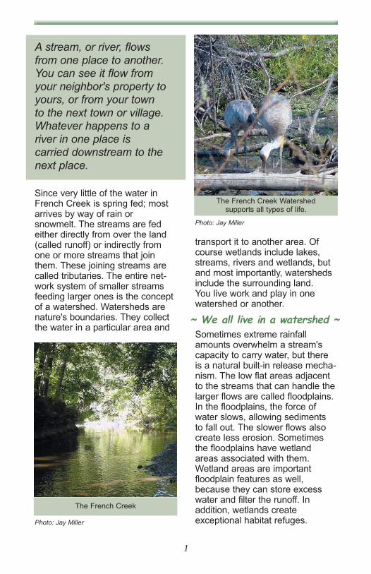
The French Creek Watershed supports all types of life.
Photo: Jay Miller
The French Creek
Photo: Jay Miller
~ We all live in a watershed ~

2
The naturally vegetated area nextto streams and rivers also serveimportant functions. These areasare called the riparian corridorsand the roots of the trees andbushes along the stream hold thestream banks in place. The trees,bushes and shrubs slow the flowof water over the land, reducingerosion of the streams. Riparianareas filter out sediments andexcessive nutrients from runoffbefore they can get into thestreams. The branches and leavesform a cover, or canopy, over thestream. This shades the stream,keeping the water cooler. Finally,the riparian areas also serve as
important habitat sites and migration corridors for wildlife.
Natural streams have definite features associated within them.Riffles are the white-water areasof the waterway, just like therapids in larger rivers. Rifflesserve to add needed oxygen tothe water and also serve as habitat sites for the smaller creatures like insect larvae, smallfish and crayfish. Pools are deeper, quieter waters and aregood fishing spots. Runs or glidesare faster moving water. The associations of good riffle-pool-runsequences demonstrate healthyriver dynamics.
French Creek is the largest tributary to the mainstem of theBlack River and an important natural resource for the region.
The U.S. Army Corps ofEngineers and the Black RiverRemedial Action PlanCoordinating Committee havedeveloped this French Creekhandbook in an effort to help youlearn about the French Creek andits geology, history, wildlife, andbeauty. The handbook will alsoexplain the findings of an intensiveenvironmental survey conductedfor the Black River RAP by theArmy Corps during 2002-2003. Finally, the handbook will presentsome ideas of how you, yourneighbors and your communitycan help protect this valuable natural resource of yours.
"Unless someone like you cares a whole awful lot, nothing is going to get better. It's not."
Theodor Geisel (Dr. Seuss)
LOR
AIN
CO
UN
TY
CU
YAH
OG
A C
OU
NTY
AvonTownship
DoverTownship
OlmstedTownship
RidgevilleTownship
ElyriaTownship
SheffieldTownship
Black River
SheffieldVillage
French Creek
French CreekWatershed BoundryBlack River
The French Creek and its watershed.
The French Creek Watershed

3
During the Ice Age, advancing glaciers covered the French Creekwatershed, along with all of north-ern Ohio. The glaciers, toweringmore than 200 feet high, scraped
the ground as they moved south-ward and brought with them a lotof material from far away. As theymelted, the land was blanketedwith a 50-foot thick deposit of thematerial, which is called glacial till,a mixture of clay, sand, gravel andboulders. Many of the rocks andboulders of the region likely camewith the glaciers from Canada.
Since the retreat of the last glacier, what is now known asLake Erie has gone through somemajor changes. The early versionsof Lake Erie were much higherand larger and had names likeLake Warren, Lake Whittlesey andLake Maumee.
Lake Erie's present elevation isabout 575 feet above sea level.Lake Warren was about 100 feethigher, Lake Whittesley was about150 feet higher and Lake Maumeewas up to 200 feet higher. As thewater levels changed, the beaches of old lake versionsremained as sandy ridges on thelandscape. Early settlers foundthese ridges to be convenienttravel routes as the sandy soilsand slight elevations rarely flooded. Today, parts of many ofthese beach ridges are still impor-tant roadways. They now carrynames like Center Ridge Roadand Chestnut Ridge Road.
The glacial till left by the glaciersand the silty bottoms of the ancientlakes are the predominant soiltypes for the region. These soilstypes are generally comprised ofmostly clay and silt loams. Thesesoils have a slow permeabilityresulting in a seasonally highwater table and a ponding of runoff waters in level areas.
Shale formations created by silt deposits on ancient lakebeds.
Photo: Ted Conlin
Geology and History
Watershed Size . . . . . . . . . . . . . . . . . . . . . . . . 38.3 Square MilesStreams. . . . . . . . . . . . . . . . . . . . . . . . . . . . . . . . . . . . . 53.4 MilesAverage Stream Gradient . . . . . . . . . . . . . . . . . . 7.6 feet per mileDrainage Density . . . . . . . . . . 1.39 Stream Mile/per Square Miles Rail Lines . . . . . . . . . . . . . . . . . . . . . . . . . . . . . . . . . . . . . 12 MilesMunicipal Roads . . . . . . . . . . . . . . . . . . . . . . . . . . . . . . 66.2 Miles

4
Wars with competing tribes compelled some to construct fortifications high on the shalebluffs overlooking French Creek.Important Native American artifacts, such as tools, ceramics,ornaments and pipes have beenfound at the Eiden and Burrell Fortarcheological sites, near whereFrench Creek meets the mainstem of the Black River.
In more recent times, the FrenchCreek area was an important stopon the old Underground Railroad.Slaves from the South arrived atthe Burrell House in Sheffield andeagerly awaited passage downthe Black River to Lake Erie andfreedom in Canada.
Normal yearly precipitation forthe French Creek watershed isabout 35 inches of rain and 42.5inches of snow. Approximatelyone third of this results in streamflow. The French Creek watershed has about 1.39 milesof streams per square mile ofland, which is normal for thisregion.
In some areas, you can seewhere centuries of silt deposits on the ancient lakebeds were compressed and over time formed extensive shale forma-tions. Here, fossils of pre-historicfish can be found.
One important discoverywas a fossil uncovered inthe shale formations aroundSheffield. It is called"Dunkleosteus" and is theremains of a 20-foot longarmored fish. It has beencalled "Tyrell's Terrible Fish."
Dunkleosteus lived in a vastinland sea that covered the areaand even sharks were suspectedto have been on its menu.Preserved in shale for over 300million years, the French Creek"Dunk" is now on display at theCleveland Museum of NaturalHistory.
The French Creek watershed has always been a popular site for human settlements. TheAdena, Hopewell, Woodland andother Native American people frequented the area to hunt andfish along the streams and LakeErie. Some set up villages in andaround the watershed.
300 million years ago, this imposing creature inhabited the French Creek area.
Illustration: Karen Carr - www.karencarr.com

5
Within the waters and along the banks of the French Creek watershed, a variety of plant andanimal life can be discovered. Of course, ducks, teals, heronsand geese are abundant. But lucky individuals can also spot pheasants, wild turkeys and a variety of hawks and owls. Deer, foxes and beavers can be found along the waterways, but one important individual might be missing.
The River Otter was once commonin Ohio until the pressures of habitatloss from the late 1800s to the early1900s drove their numbers down.They have not been seen in thegreater Black River watershed forsome time.
From 1986 to 1993, the OhioDepartment of Natural Resourcesreintroduced the species into theGrand River, Killbuck Creek, LittleMuskingum River and StillwaterCreek. The bordering states ofIndiana, Kentucky, Pennsylvania andWest Virginia had River Otter reintroduction programs as well. Therestocking has been so successful,River Otters have been spotted in51 Ohio counties. To date, nonehave been seen in either FrenchCreek or the Black River watershed.Although tracks have been seen thatare believed to be from river otters,one has not been spotted in FrenchCreek or the greater Black Riverwatershed. If you spot a River Otter,you are asked to report it to ODNR,Division of Wildlife at 330-644-2293.
Wildlife
The French Creek watersheddisplays a kaleidoscope ofland uses. The beauty of thewatershed comes from itsrural/suburban nature. Almosthalf of the land in the water-shed is used for agriculturalpurposes and woods coveranother third of the land. Asdevelopment continues in theFrench Creek area, the landuses will change quickly.
Land Usesin the
French Creek WatershedLO
RAI
N C
OU
NTY
CU
YAH
OG
A C
OU
NTY
AvonTownship
DoverTownship
OlmstedTownship
RidgevilleTownship
ElyriaTownship
SheffieldTownship
Black River
3 0 3 6 Miles
Open WaterLow IntensityResidentialHigh Intensity ResidentialCommercial/Industrial/TransportationQuarries/Strip Mines/Gravel PitsTransitionalDeciduous ForestEvergreen ForestMixed ForestPasture/HayRow CropsUrban/Recreational GrassesWoody WetlandsEmergent Herbaceous Wetlands
LOR
AIN
CO
UN
TY
CU
YAH
OG
A C
OU
NTY
AvonTownship
DoverTownship
OlmstedTownship
RidgevilleTownship
ElyriaTownship
SheffieldTownship
Black River
SheffieldVillage
French Creek
Land use within the French Creek watershed is very diverse.
Land Uses
The River Otter has beensorely missed in the area.
Photo: Courtesy of www.otternet.com

6
There is an ample supply of thingsto do in the French Creek water-shed. Stretch your legs on one of the many nature paths in theFrench Creek Metroparks - maybe you can find one of the animalsnoted above. Golfers have a variety of spots to hone theirgames and shoppers can browsethrough the French Creek DistrictShops in Avon.
Recreational Opportunities in theFrench Creek Watershed include:Lorain Metroparks -
• French Creek Reservation• James Day Park
Golf Courses -• Avondale, Hillliard Lakes, • Bob O'Links, Red Tail
French Creek District ShoppingSteelhead Fishing in French Creek
As you can see, the French Creekwatershed is full of ecological, historical and recreational importance. So, who wouldn'twant to live here? The area has a small town feel with quiet communities but is close to boththe Lake Erie north coast and themetropolitan areas of Elyria,Lorain and Cleveland. The FrenchCreek watershed area has astrong historic background withbeautiful vistas and peacefulgreen areas.
But the face of the French Creekwatershed is changing. With thewestward expansion of GreaterCleveland and the eastwardexpansion of Lorain, the FrenchCreek watershed is caught in themiddle. It is the northeastern gateway between Lorain Countyand Greater Cleveland. With thatfact comes the head on collisionof the needs of the natural watershed and the changing landuses of development.
During these times, it is extremelyimportant to get involved inenhancing and protecting yourwatershed.
"Uncontrolled growth anddegradation of our naturalresources will provide a few with immediate gain,but will ultimately cost theentire populace."
Lorain County Comprehensive Plan 2000
"Living along French Creek" canremain a positive venture. And asyou help protect the FrenchCreek watershed, you, as ahomeowner, may be helpingyourself in the process.
In studies that compared the valueof residential properties, theappraised value of homes alongnatural streams is three timeshigher than a comparable homealong a channelized stream. Mostpeople enjoy natural settings andwildlife viewing and are willing topay a higher price to enjoy thesebenefits. The closer the property isto a natural area, the higher theprice prospective buyers are willing to pay.
Recreaationaal Opportunities
Living Along French Creek

7
U.S. Army Corps of Engineers Survey of French Creek
1 - SurveyBeginning in the summer of 2002,the U.S. Army Corps of Engineers(USACE) - Buffalo District initiateda comprehensive survey of theFrench Creek Watershed. Thepurpose of the survey was to perform evaluations on all of thestreams and tributaries within theFrench Creek watershed utilizing:
• Qualitative Habitat EvaluationIndex (QHEI) on the largerstreams, and,
• Primary Headwaters HabitatEvaluation Index (HHEI) on thesmaller streams (streams withdrainage area of less than 1square-mile).
In addition, any adjacent wetlandareas were evaluated utilizing theOhio Rapid Assessment Method(ORAM).
The objective of conducting theQHEI, HHEI and/or ORAM evaluations was to facilitate acomprehensive 'walk-over' of thewatershed to ascertain baselineconditions of the riverine habitat.Utilizing numeric habitat assess-ments, such as those notedabove, any changes to the habitat'health' of the watershed can bemonitored over time.
The initial intent of this FrenchCreek sub-watershed evaluationwas to be able to identify areaswithin the watershed where conditions are good, and moreimportantly, identify areas whereconditions are becoming or currently are poor. The FrenchCreek survey also provides for the
development of recommendationmeasures to improve the overallcondition of these areas and thewatershed as a whole.
The stream segments investigatedduring this survey included portions of the following:
• French Creek• Unnamed Tributary to French
Creek at River Mile 0.38(Quarry Ditch1)
• Jungbluth Ditch (Sugar Creek2)• Walker Ditch (Fish Creek2)• Kline Ditch• Avins Ditch• Unnamed Tributary to French
Creek at River Mile 8.9(Schwartz Ditch1)
• Mills Creek• Unnamed Tributary to French
Creek at River Mile 12.8(French Ditch1)
• Unnamed Tributary to FrenchCreek at River Mile 14.3(Nagle Ditch1)
Aerial photographs, existing GISdatabases, and traditional papermaps were used to determinepotential sampling points for theinvestigation. Points were selectedmainly at road crossings, accesstrails, or other readily accessiblefeatures. A total of 70 locationswere identified as potential sampling points, however, actualevaluations were conducted atonly 51 of these sites (Table 1).
1 Name given by USACE field personnel - not ‘official’ name2 According to French Creek Reservation Trail Guide

8
Table 1
NOTES: River Miles (RM's) for most of the ditches as well as the final four French Creek sites havebeen estimated using ArcView in conjunction with the 1999 aerial maps. These estimated RM's arenot intended to replace the official RM's contained on OEPA's official RM maps, but are insteadbeing used as a reference point for the purposes of these investigations (as actual RM's wereunavailable). Likewise, due to discrepancies between several different maps and the lack ofassigned names on some creeks, names were assigned to the waterways for reference purposesonly. Those names appear above in quotation marks.No QHEI/HEEI conducted at sites where names above are depicted in italics.

9
NOTES: River Miles (RM's) for most of the ditches as well as the final four French Creek sites havebeen estimated using ArcView in conjunction with the 1999 aerial maps. These estimated RM's arenot intended to replace the official RM's contained on OEPA's official RM maps, but are insteadbeing used as a reference point for the purposes of these investigations (as actual RM's wereunavailable). Likewise, due to discrepancies between several different maps and the lack ofassigned names on some creeks, names were assigned to the waterways for reference purposesonly. Those names appear above in quotation marks.No QHEI/HEEI conducted at sites where names above are depicted in italics.
Table 1 (continued))

Although formal QHEI/HHEI eval-uations were not conducted at theremaining sites, mainly due to lackof access, photographs and gen-eral site notes were taken at all ofthe sites, including those whereevaluations were not conducted.
2 - Survey FindingsLack of riparian corridors is the main concern in theFrench Creek Watershed
A - QHEI Survey ResultsIn general, the QHEI survey conducted on French Creek andits tributaries showed a downwardtrend in QHEI scores, startingfrom the mouth and progressingupstream through the headwatersof the creek. The sites within thefirst section (RM's 0.1 - 6.9) of the creek received on average favorable scores that are consis-tent with the creek's designationas warmwater habitat (WWH).
Warmwater Habitat defines the 'typical' warmwater communities of aquatic organisms forOhio rivers and streams.WWH represents the principal restoration targetfor the majority of waterresource managementefforts in Ohio.
The second section of the creek(RM's 7.65 - 14.1) received scoresthat would put the creek in non-attainment of its WWH designation. Figure 1 depicts aschematic of the French Creekwatershed, and show the QHEIscores attained at each of theFrench Creek sites.
The following pages give a brief description of the findingsand observations derived from the survey in each portion ofFrench Creek.
10
French Creek QHEI Scores
0
10
20
30
40
50
60
70
80
90
0.1 0.38 0.54 1.4 3.2 4.0 4.5 5.5 6.1 6.9 7.65 8.9 10.4 10.7 12.4 12.7 14.1
French Creek River Mile
QH
EI S
core
Figure 1French Creek QHEI Scores
French Creek River Mile
QH
EI S
core

River Mile 0.1 through 6.9: Withthe primary exceptions of the siteat the mouth of French Creek (RM0.1) and the site located near theI-90 crossing (RM 4.5), the lower7 river miles received QHEIscores that would be consistentwith a designation as WWH, withan average score of 63.5. The siteat the mouth of the creek receiveda low score due to several factors.First, the river bottom at the site,while dominated by gravel, washighly embedded with silt. Siltdeposits that blanket a river bot-tom can impair aquatic life suchas insects and crayfish. Amplifyingthis effect is that this portion of thecreek is relatively straight, over 1meter deep, extremely slow moving (some flow reversaleffects were also noted from theBlack River mainstem) anddemonstrates no true riffle/poolcomplex. Riffles provide forair/water mixture increasing theamount of available dissolved oxygen for fish and insects.
The artificially straightened riverconditions decreases stream flowvelocity, allowing for a significantamount of suspended sediment inthe creek to settle out in this location. The suspended sedimentin the river can even cause an irritation to or a clogging of fish gilltissues.
At the I-90 crossing site, the creekwas evidently re-routed for theconstruction of the I-90 and alsomaintains a glide habitat. Due tothe relocation of the creek, thearea is almost completely straight,and demonstrates moderate siltembeddedness, slow flows, andlittle riffle/pool complex. This portion of the creek is also
adjacent to an old fly-ash disposalarea, and is also in close proximityto two large gas stations, one ofwhich had a large fuel spill into thecreek in December of 2002.
The above exceptions aside, the majority of thisportion of the creek runsthrough areas with minimal development (such as the Lorain County MetroParks - French CreekReservation) and is of relatively good quality.
In general, this portion of thecreek has moderate to wide ripari-an buffers zones (over 10 meters),dominated by forested and/or old-field habitat. Substrates in thisportion of the creek were dominat-ed by cobble, gravel, sand andbedrock with normal levels of siltembeddedness. Because thecreek runs through areas withwide to moderate riparian buffers, in-stream cover was generallygood, and reasonable channeldevelopment with deep pools(over 70 cm) and riffles (over 10cm) dominated. Two wetlandswere also identified within this portion of the watershed. One isconnected to French Creek by"Quarry" Ditch at RM 0.38 and is a wetland created by past quarrymining activities (around 23acres). The other is located nearthe northwest corner of the intersection of French Creek andEast River Road. This wetland is asmall (around 2.5 acres) forestedfloodplain wetland, which is sea-sonally flooded by French Creek.
11

Although this portion of the mainstem of French Creek is of relatively good quality, some unfavorable issues were noted inthe tributaries in this section of thewatershed. Five tributaries flowinto French Creek in this portion ofthe watershed: "Quarry" Ditch (atRM 0.38), Jungbluth Ditch (at RM0.54), Walker Ditch (at RM 1.23),Kline Ditch (at RM 3.9), and AvinsDitch (at RM 4.0). A total of 20sites were investigated on thesetributaries, and 15 of the 20 sitesreceived QHEI scores that werewell below the level for the attainment of WWH designation,with an average score of 49.2.The only sites that received QHEIscores above the level for WWHdesignation attainment were eachof the first two sites on JungbluthDitch and Walker Ditch where theyflow through the Lorain CountyMetro Parks French CreekReservation, and the first sitetaken at Kline Ditch. The primaryproblems identified at the remaining sites were issues associated with runoff from theextensive residential developmentin the watershed. Most sites hadlittle, if any, riparian buffer areaswith mowed lawns up to thestreambanks. In many cases, thestreams had been re-routed orculverted to accommodate development, or were 'ponded'into retention basins within developments. Several instanceswere noted where ongoing construction offered little, if any,best management practices toprotect the streams from theimpacts of the land disturbanceactivities. All of these issues arecausing significant run-off andsedimentation into the streams,and are impacting and/or
eliminating in-stream habitat andalso having an adverse effect onwater quality.
River Mile 7.65 through 14.3: Thesites investigated on this portion ofthe main stem of French Creek allreceived scores that would put thecreek in non-attainment of itsWWH designation. The averageQHEI score of the sites in this portion of French Creek was 40.6.In this portion of the watershed,the creek flows through an areathat is developed to a greaterextent than the downstream portions, and is dominated by residential and commercial uses.Here, the primary water qualityand river habitat problem notedwas the lack of riparian buffers. Inmost cases, riparian buffers measured less than 5 meters inwidth, and in many cases nobuffer was present.
The lack of adequate buffersleads to very flashy stormflows, increased riverbankerosion and increased run-off and sedimentation,which were noted in substrate evaluations.
While some moderate amounts ofcobble, gravel, and bedrock werepresent at many of the sites, apredominance of silt and sandsubstrates was evident. Alsoattributable to the lack of riparianbuffers was a general lack of highquality in-stream cover in this portion of the creek. Most sitesinvestigated within the creek alsowere channelized, re-routed, orotherwise altered to accommodate
12

residential and commercial devel-opment, which has impacted thecreek's sinuosity and developmentof riffle/pool complexes. Rifflesand pools tended to be muchshallower in this portion of thewatershed, also.
As seen in the French Creekmainstem, the sites investigated inthe tributaries to French Creek inthis portion of the watershed alsoreceived QHEI scores that wouldbe in non-attainment of WWHdesignation. Four main tributariesflow into French Creek in this portion of the watershed:"Schwartz" Ditch (at RM 8.9), MillsCreek (at RM 9.3), "French" Ditch(at RM 12.85), and "Nagle" Ditch(at RM 14.3). The average QHEIscore of the sites investigated onthese tributaries was 45. The mainfactors contributing to the lowscores are similar in nature tothose that affect the main stem ofthe creek, as well as the tributar-ies in the other portion of thewatershed. These include extensive development, streammodifications/relocation, lack ofriparian buffers, silt embeddedsubstrates, run-off/sedimentation,and construction impacts.
B - Water Quality Data and Trends
In late May of 2003, water qualitydata were collected at each of the51 sites where QHEI evaluationswere conducted. This data wascollected using a Hydrolab fieldmonitor, Hach field tests, and aturbidity meter. Parameters testedduring this effort included:
• Water Temperature (F°),• Dissolved Oxygen (mg/L),• Conductivity (mS/cm),
• Salinity (ppt),• pH,• Redox Potential,• Ammonia Nitrogen (mg/L),• Free Chlorine (mg/L),• Total Chlorine (mg/L),• Phosphate (mg/L),• Phosphorus (mg/L),• Nitrate nitrogen (mg/L),• Nitrite nitrogen (mg/L), and• Turbidity
In general, no significantexceedances of State water quality standards were noted during the water quality data collection effort. The primaryparameters that were found to be at levels of some concernincluded low dissolved oxygenand high nitrate/nitrite nitrogen.
Several sites throughout thewatershed exhibited low levels ofdissolved oxygen. Typically, sitesthat had low dissolved oxygen levels tended to be the ones thatalso had elevated levels ofnitrate/nitrite nitrogen. The lack ofriparian buffers, particularly in theupstream portion of the water-shed, allows the elevated levels ofnitrogen to enter the river system.Urban runoff containing high levelsof fertilizers and other compoundscontaining nitrogen is carried tothe creek virtually unfiltered inmany cases, and is likely a primary cause for the elevatednitrogen levels. Elevated turbiditylevels (lack of water clarity) werealso noted in several sites, andare also likely caused by the introduction of suspended silt-laden runoff due to the lack ofadequate riparian buffers.
13

14
• Improved enforcement of exist-ing State and local storm waterregulations. Many constructionsites encountered during theFrench Creek study did notappear to be in compliance.Silt fences were not used regularly where required alongstream channels, etc. Localmunicipalities need to be educated on the regulationsand held responsible for compliance.
• Improved enforcement of existing Federal and StateSection 404 and 401 regulations. Suggest thatmunicipalities be educated andheld responsible for ensuringthat compliance with theselaws is obtained prior to, during, and after the construction of new residential subdivisions, commercial andindustrial developments.Several instances of severeimpact to stream channelswere encountered during theFrench Creek study, includingdrastic alterations to the channels themselves, widespread culverting andconstructing retention pondswithin the former channels.
• Encourage (both voluntarilyand with the use of incentives)the development of woodedbuffers adjacent to FrenchCreek and its tributaries. Thedevelopment of buffersimproved both habitat andwater quality.
• Create wetland filtration wetlands in areas wheresevere erosion is adding to thesediment loads of the creekand its tributaries. Restoreexisting wetland areas. Thesewetlands serve the dual purpose of improving waterquality by absorbing nutrientsand filtering out sediment andlimiting flood damage to adjacent structures.
• Enforce local health depart-ment regulations in relation toresidential septic systems.Various failures of these systems were noted during theFrench Creek study.Coordination with the HealthDepartment and OEPA isencouraged to rectify the discharge of raw sewage intothe creeks. Opportunities mayexist through the OhioEnvironmental Infrastructureauthority (Section 594).
• Construct bioengineering erosion control projects wheresevere erosion is occurringalong stream banks.
• Curtail discharge of stormwaterrunoff from urban areas directly into French Creek andits tributaries. Encourage thedevelopment and use of stormwater detention basins (notretention basins).
3 - Restoraation RecommendaationsSeveral measures can be taken to encourage improvementsin the habitat and water quality of French Creek and its tributaries:

15
Lawns and LandscaapingMany times, the things we do toimprove our vistas or our lawnsdisrupt the natural systems thatare necessary for the health of thestreams in our backyards.Removing natural vegetationalong the stream banks or replac-ing it with lawns might look nice inthe short run, but it will lead to anerosion of the stream bank. Theroots of the trees and shrubs holdthe stream banks in place; withoutthem, there is nothing to slow theforce of the moving waters. Prettysoon your pretty stream sceneswill be replaced with an erodingriverbank and a loss of what couldbe sizeable portions of your land.Allow a little shrub/tree corridorbetween your lawn or field and thestream, don't plant lawn or mow tothe river's edge; you are just inviting the problems of erosiononto your property.
The fertilizers you use on yourlawn can be too powerful for thestream; so don't over-fertilize yourlawn. These chemicals can becarried with runoff waters directlyto a stream, especially if there is
no natural shrub/tree corridor toabsorb them. In a stream, the fertilizers can lead to unsightlyblooms of algae, a decrease ofavailable dissolved oxygen, andfish kills.
Don't dump your lawn clippings in the stream. In addition to degrading the beauty of a stream,their decomposition can lead to a decrease in dissolved oxygenand fish kills.
Use pesticides and herbicidesaccording to the manufacturer'sinstructions. Excessively appliedamounts of these chemicals canmake their way to the streams andwreak havoc with the natural system. Proper disposal of thesematerials is critical. Contact theLorain County Solid WasteManagement District at 440-329-5440 for more information or col-lection days for these chemicals.
Plant only native species near thewater's edge. Native plants areaccustomed to the climate of yourarea and won't be affected by theextremes in Ohio's weather likesome non-native species wouldbe. Your local greenhouse or theLorain Soil and WaterConservation District may be ableto help you in selecting appropri-ate native plant species.
By following these simple suggestions, you will be rewardedwith a more natural stream in your backyard, increasing numbers of wildlife species, andpossibly an increase in propertyvalues as well.
Excessive fertilizer runoff can lead toincreased algae growth.
Photo: Jay Miller
But Whaat Caan I Do In My Little Backyaard??

16
Decreaase the Amount of Runoff
Slowing the surface runoff fromplaces like roof, patios and driveways will minimize theamount of soil that can get to thestreams. Excessive amounts ofsoil reaching the streams are amajor problem throughout theentire Black River basin, includingFrench Creek.
Look for and repair areas in youryard that show the signs of erosion. You should look for barespots on your property andexposed tree roots. Small stonesappearing on soil surface and the appearance of rills and gullies are other indications of erosion. The Lorain Soil andWater Conservation District has developed a brochure called theLorain County Water QualityGuide that will help you under-stand the problems of erosion and what to do about it on yourproperty.
Maintaain Your SepticTank System
Properly located and maintained,your septic tank and leach bedsystem can be an effective meansfor the treatment of householdwastes. For this type of system(called a Home SewageTreatment System or HSTS) towork effectively, it must be locatedin proper soil types and not withinan area of extremely slopingground. It is the soil and bacteriain the soil that actually treat thewastes. A system located on aseverely sloping ground cancause a rapid runoff of the liquidwastes therefore not allowing for the time necessary for bacteria totreat the wastes.
Improperly located, installed ormaintained systems can severelydegrade the streams and canallow bacteria and viruses topotentially cause serious healthproblems.
An HSTS system is not a "set andforget" system and must be peri-odically inspected by qualified per-sonnel to ensure that it is operat-ing properly. In addition, the septictank must be routinely pumped ofaccumulated solids and scum.
Drawing: Ohio State University Extension
Home Sewage Treatment System
Septic Tank
Drawing: Ohio State University Extension

17
Information on HSTS systems can be obtained through the Ohio StateUniversity Extension Office or the Lorain County General Health District.Some fact sheets and additional information can be found on the web at:
Lorain County General Health District: http://www.loraincountyhealth.com/environmental.shtml
Ohio State University Extension:http://ohioline.osu.edu/aex-fact/0740.htmlhttp://ohioline.osu.edu/aex-fact/0741.htmlhttp://ohioline.osu.edu/aex-fact/0742.html
Don't dump anything intostreams or storm sewers.Storm sewers will deliver the wastes to the streams without treatment. Follow the mantra of today's more ecologically sound lifestyles,"Reduce - Reuse - Recycle."
Use alternative products insteadof hazardous household materials.A list of alternative products canbe found in the "Lorain CountyWater Quality Guide." When youmust use a potentially hazardousmaterial, read the label and followthe directions carefully. Do notflush these chemicals down thedrain into either a public sewersystem or a home sewage treatment system. The LorainCounty Solid Waste District hasset up collection dates and timesfor household hazardous wastes.
Old fluorescent tubes, thermostatsand mercury thermometers cancontain considerable amounts ofmercury. In a river system, that
mercury can be transformed into a more toxic type of mercury, called methyl mercury. Please dispose of these items by turningthem into approved collection facilities. The Lorain County SolidWaste District has set up collectiondates and times for fluorescenttubes and ballasts.
To contact the Lorain County SolidWaste District for additional information or for a schedule ofupcoming collection days call: 440-329-5440. Or you may accessthem on the web at:
Other Useful Suggestions To Help Preserve The French Creek Watershed
http://www.lorcnty.org/waste/default.asp

18
Learn about and be able to recognize potentially troublesomeinvasive species, like PurpleLoosestrife and Phragmites. Theproliferation of these invaders is asevere problem throughout theGreat Lakes by replacing nativespecies and clogging waterways.Learn the best method of control-ling the spread of these plants.
Try to keep your automobile ingood working order.
Photo: Ted Conlin
Photo: Paul Anderson
Purple Loosetrife
Photo: Jay Miller
Since most of your travelsthroughout the French Creekwatershed will start and end byautomobile, it is important to keepyour car in good working order. Oiland gasoline leaked onto drive-ways, parking lots and streets findtheir way to the water system byway of ditches and storm sewers.Don't dump used or unwanted oilinto a storm sewer; take it to arecycling center.
Leaking oil and gasoline will find it’s into the water system.
Photo: Dave Stroud
Phragmites

Some communities are also incorporating the protection ofwetland areas as well. For thesake of the French Creek basin, it is important for you and yourcommunity to adopt, support andenforce stream protection ordinances, especially thosedesigned to protect riparian areasand wetlands. These ordinancesnot only protect your property from flooding and erosion; theyhelp your downstream neighborsas well.
Identify areas of the watershedthat could be protected, improvedor rehabilitated, like erodedstream banks and wetland areas.Support efforts to repair, enhanceand preserve these areas. TheU.S. Corps of Engineers has identified several of these areas,as part of their Black RiverRAP/French Creek assistanceproject. The Black River RAPCoordinating Committee may beable to assist you in seeking fundsfor these projects.
Encourage programs that dealwith the handling, storage, andproper use and disposal of hazardous wastes. Develop clean-up days that provide for drop-offlocations of these products.
"Achieving a balancebetween the needs of theenvironment and the desirefor growth and economicgain is key to the well beingof the County."
Lorain County Comprehensive Plan 2000
Ensure that Best ManagementPractices are used during andafter construction of new developments. These practiceshave been designed to keepexposed soils from getting into the streams.
Encourage and support a wetland design of new stormwater retention basins in new subdivisions. The new designs will create new habitat for wildlifeand will reduce the amount of soil getting into the French Creekwater system.
Develop and support an initiativeto control the spread of invasivespecies, like Purple Loosestrifeand Phragmites. Incorporate thebest methods of controlling thespread of these plants in smalland large-scale infestations.
Many communities are nowunderstanding the importance ofnative streamside vegetation andits ability to reinforce the streambanks and to decrease theamount of sediment, nutrients,pesticides and herbicides that canenter the stream. These communi-ties have developed setback ordinances in the planning stagesof development.
19
Whaat caan my community and I do together??

20
Talk to your neighbors, friends,community officials and organiza-tions about the importance ofeveryone pitching in to protecttheir valuable water resource. Agood idea might be the formationof a French Creek watershed
group or a watershed stewardshipprogram. The Black River RAPwould be happy to help you formsuch a group. Suggested mem-bers of the group would be localhomeowners & businesses andlocal government officials.
Lorain County Soil & Water Conservation District440-326-5800
Lorain County General Health District440-322-6367www.loraincountyhealth.com/environmental.html
Lorain County Solid Waste Management District440-329-5440www.lorcnty.org/waste/default.asp
Lorain County Community Development Department440-244-6261
Lorain County Metroparks440-458-5121www.loraincountymetroparks.com
Lorain County Community Alliance440-366-4160
Ohio Environmental Protection Agency330-963-1131 (Ted Conlin-Black River RAP Coordinator)
Ohio Department of Natural Resources, Division of Wildlife330-644-2293
U.S. Environmental Protection Agency440-250-1720
U. S. Department of Agriculture-Natural Resource Conservation Service
440-326-5800Black River Remedial Action Plan
www.noaca.org/blkrap.htmlwww.epa.gov/glnpo/aoc/blackriver.html
Northeast Ohio Areawide Coordinating Agency216-241-2414 (Pam Davis-Black River RAP Secretariat)
Isaak Walton League-Lorain County Ely Chapter440-647-5074
The Ohio State University Extensionhttp://ohioline.ose.edu
Your local government officials
And Finaally....
Contaacts

ResourcesPPublicaations::Explorations of a Watershed, The Natural History of the Black River,Edited by Brad Masi, Oberlin College, Oberlin OhioCommon Groundwork, A Practical Guide to Protecting Rural and UrbanLand, Third Edition, Joseph H. and Mary M. Chadbourn, 2000,Chadbourne & ChadbourneEngineers For The Public Good, A History of the Buffalo District U.S.Army Corps of Engineers, Nuala Drescher, U. S. Army Corps ofEngineersBlack River Study, An Interpretive Study of the Black River for Inclusioninto Ohio's Scenic Rivers Program, Russell W. Gibson, OhioDepartment of Natural Resources, August 29, 1977, Appended March1998The Lorax, Dr. Seuss, Dr Seuss Enterprises. L.P., Random House, 1971Soil Survey Map of Lorain County, Ohio, USDA, ODNR, July 1976
WWeb SSites::
21
Lorain County Metroparkswww.loraincountymetroparks.com
West Virginia Universityhttp://www.nis.wvu.edu/2002_Releases/OttersStudy.htm
River Otter Alliancehttp://www.otternet.com/ROA/news.htm
Yahooligans.comwww.yahooligans.com/content/animals/trach/3909.html
Connecticut Rivers Joint Commission - Buffer Websiteswww.crjc.org/buffers/Introduction.pdfwww.crjc.org/buffers
/Backyard%20buffers.pdf www.crjc.org/buffers/Guidance%20for%20Communities.pdfwww.crjc.org/buffers%20for%20Agriculture.pdfwww.crjc.org/pdfiles/rivdynero.pdfwww.crjc.org/corridor-plan/plan-riverwide1.html#Goals-river
National Academies Press Riparian Areas: Functions and Strategies for Management
(2002) www.nap.edu/books/0309082951/htmlU.S. EPA
www.epa.gov/owow/watershed/wa1.html

AAbout the UU..SS.. AArmy Corps of EEngineers::The United States Army Corps of Engineers has, at its disposal, the talent, skill, ingenuity and resourcefulness that are requisite for the creation of a viable defense establishment, as well as the constructionof numerous public works projects erected for the public good; it hasplayed a key role in the discovery and development of the wealth of the Great Lakes Region.
AAbout the WWaater RResource DDevelopment AAct::The Water Resource Development Act of 1990 authorizes the U.S.Army Corps of Engineers to support the development and implementa-tion of Remedial Action Plans at U.S. Areas of Concern on the GreatLakes. Section 401 of the Act enables the Corps to provide technicalsupport to State and Local Governments, and non-profit agencies.
AAbout the BBlaack RRiver RRemediaal AAction PPlaan::The Black River Remedial Action Plan Coordinating Committee is a group of watershed stakeholders, representing local public agencies, state and federal agencies, industries and private commercial groups and citizen representatives that have been working together to restore the Black River Watershed. The Black River Watershed is the only Great Lakes Area of Concern in Ohio that encompasses the entire watershed.
22

Created by the U.S. Army Corps of EngineersUnder the Water Resource Development Act
Assistance to The Black River Remedial Action Plan