Embed Size (px)
Citation preview

A Walk Around Laleham Village
The long history of our village has been well recorded in ‘The Laleham Common Place Book’ and in ‘Our Dear Laleham’; both books were written and compiled by the late Oswald Adamson. The village name is recorded as ‘Laelham’ on 10th Century charts; the word probably coming from ‘lael’ meaning twig and from ‘ham’ meaning water meadow or village. 5th Century Iron Age spearheads have been found in the Thames at the site of the former Laleham Ferry, suggesting that this has long been used as a crossing point. The foundations of our Parish Church of All Saints date back to the 12th Century and records show that in the 13th Century the monks of Westminster had their "Grange" and watermill on the banks of the Thames, very close to the site of Laleham Abbey. In 1970 much of the centre of the village was designated as a Conservation Area in order to protect our heritage for future generations. The walk was planned and compiled by Susan de Pear, on behalf of The Laleham Society (now Laleham Residents Association), with acknowledgement to all contributors to the two Laleham books from which much of the information is gleaned. Thanks also to local artist Matthew Wright, for the use of some of his sketches and thanks to former pupils of Matthew Arnold School; Jessica Harris & Kim Underwood for the line drawings, and David Williams & Paul Mitschke for drawing the outline map. This pamphlet is provided by Laleham Residents Association and was most recently updated in June 2016. For further information about the Association and about Laleham, see http://www.lalehamonthames.com
The Walk The River Thames provides a natural western boundary to the village and there are three routes towards the neighbouring communities of Ashford, Shepperton and Staines which diverge from the junction and roundabout outside All Saints churchyard’s north gate, close to the War Memorial (No 14 on the village plan, page 2). This walk is presented in three sections; each is a circular route beginning and ending at this central point and a minimum walking time is given for each section. Refreshment is available at any of our three village pubs, The Three Horseshoes, The Feathers or The Turk’s Head, also at Notcutts Garden Centre (Staines Road) and at Meson Toby Restaurant (Ashford Road). Section 1 - The Broadway / Ashford Road / All Saints Church - 30+ minutes Section 2 - Staines Road / Thameside / Blacksmiths Lane / War Memorial - 30+ minutes An optional extended walk to Penton Hook, its lock and island is outlined. Section 3 - Vicarage Lane / Ferry Lane / Laleham Abbey and Park / Shepperton Road - 35+ minutes An optional extended walk to Chertsey Bridge is outlined. The majority of the properties described are private residences. We hope you find the walks interesting and enjoyable and we ask that you respect the privacy of our residents.
Thank you.

A Walk Around Laleham Village
2
- - - - Conservation Area boundary
(1) Church Farm (13) High Elms and Yew Corner (2) The Village Hall (14) The War Memorial (3) The Limes (15) Dial House (4) Manor Farmhouse and Barns (16) Old Farm (5) Cambridge Cottage and Red Cottage (17) Little Ravenswell (6) Laleham School (18) Laleham House/Abbey (7) The Turk's Head Public House (19) The Thatched Cottage (8) All Saints Church (20) The Coverts (9) The Tower (21) Muncaster House (10) Harris Boatyard (22) The Shops (11) The Old Forge and Forge Cottage (23) Three Horseshoes Public House (12) Plane Tree (24) The Nursery and Orchard Wall

A Walk Around Laleham Village
3
Section 1 - The Broadway / Ashford Road / All Saints Church (30+ minutes)
The walk begins at Church Farm (1), situated adjacent to the Church and at the junction of The Broadway and Staines Road. This is an early 17th Century brick farmhouse with Georgian alterations and is an excellent example of a central chimney house, having a standard layout for such a house, with a living room on either side of the central chimney. The entrance is through a tiled two-storey porch, with stairs filling the space on the opposite side of the chimney to the doorway. It once housed the Lucan Family’s bailiff and was sold by the Lucan estate in 1966.
(1) Church Farm
The traditional roadsign outside Church Farm shows the route towards Ashford along The Broadway, passing the Recreation Ground entrance, the allotments and the Heritage Centre and on to The Village Hall (2). The land on which all these amenities stand was given to the village by the Fourth Earl of Lucan in 1907 and the foundation stone of the Village Hall was laid by Lady Lucan in 1908. It is here that The Laleham Players performed throughout the 1940s, 50s and 60s and it’s the regular meeting venue for many local groups. The original plans for the Village Hall can be seen in the book ‘Our Dear Laleham’. Does the Village Hall look familiar? It featured in an episode of ‘Call the Midwife’ in January 2016.
(2) Village Hall Walking on towards Ashford you pass Home Farm Cottages (1876), these are similar to the School Cottages across the road, which will be described later. You will also pass The Feathers public house (1796) with its large forecourt; typical of pubs that were staging points on transport routes. The next house of interest is The Limes (3), an early 18th Century farmhouse with double pile old tile roof. The front is stuccoed and the back is of yellowish field bricks.
(3) The Limes Cross the road outside The Limes. Continuing towards Ashford you pass many charming 18th Century cottages, nestling between more recent houses, until you reach Meson Toby, which is immediately before the bridge over a water channel. This 18th century property was built as a private residence until Albert King opened his house to serve teas about 40 years ago and it has since become a restaurant. Opposite the restaurant is the Village Pond, a historic feature which was lost for many years before being recreated and developed, since 1997, as a wildlife habitat area (As such, this is a fenced area with limited opening times).

A Walk Around Laleham Village
4
Walk back towards the village to Manor Farm, with its listed farm buildings (4).
(4) Manor Farmhouse and Barns Adjacent to Manor Farm are a good pair of early 18th Century brick houses, now called Cambridge Cottage and Red Cottage (5). The porches were added at a later date. Inside both are many Georgian features including red quarry tiled flooring, panelling and shutters, stairs winding round a newel post and semi circular brick parlour fireplaces. The Red Cottage has deeds dating back to 1726; Cambridge Cottage was formerly an inn called ‘The Generous Britain’. Both have large walled gardens at the rear.
(5) Cambridge Cottage & Red Cottage Walking back towards the village you pass more Victorian cottages and School Cottages (1873) with their pointed gables, diaper pattern brickwork and Lucan coats of arms. Laleham Church of England School (6) was opened in 1865, the land having been given by the Third Earl of Lucan. The New Junior School was built in the playground in 1959 and a further extension block was added in 1977. A detailed history can be found in ‘Our Dear Laleham’.
(6) Laleham School Next to the school stands Glebe House, built in 1865 as the vicarage. It stands on the site of Thomas Arnold's house and private school. These were demolished in 1864, with the bricks being re-used in the new school.

A Walk Around Laleham Village
5
Further towards the village centre is The Turk's Head public house (7). The name may just refer to the knot, although this pub name is generally attributed to the time of the Crusades when returning soldiers brought back dried heads as trophies which, when exhibited in the ale houses of the time, attracted customers in large numbers. Laleham’s Turk’s Head is more recent, circa. 1867. Its exterior has beautiful hanging baskets throughout the summer months. Adjacent are Wisteria Cottage and Corner House, both listed buildings.
(7) The Turk's Head Public House This section of the walk ends at All Saints Church (8), the oldest and most historically important of all our many listed buildings. Inside, 12th Century pillars and arcades still remain; a pre-reformation altar slab is preserved on the West wall and medieval graffiti is to be seen in several areas. Stained glass windows, memorials, grave slabs and wall plaques all add significantly to the history of All Saints, telling of various families and persons from Laleham's past. Parish Records, which date from 1538, are no longer kept at the church. They were removed for safe custody to the Greater London Records Office in 1983. Further detailed description of the wealth of heritage within its walls is contained in the two books on Laleham.
(8) All Saints Church The church is aligned broadly east-west, with the tower at the west end. Looking at the Church from below the tower and within the churchyard, a very small amount of the original 12th century west wall can be seen. The Tower (9) was brick built in 1730 to replace a wooden steeple and had to be extensively repaired and buttressed a hundred years later. At the north side is the Lucan Chapel with its red Tudor brickwork. Walking further around the churchyard, the Lucan Memorial can be seen in the graveyard at the east end. Here the Earls of Lucan are buried. Both the north and the south walls were rebuilt and the geometrically designed windows were restored in 1889. It is possible that the present porch was added at this time. To the south side is the grave of Matthew Arnold, his wife and three of their sons, who died young.
(9) The Tower

A Walk Around Laleham Village
6
Section 2 - Staines Road / Thameside / Blacksmith's Lane / War memorial (30+ minutes) Begin this section by walking north from the road junction towards Staines. Here, Staines Road was formerly known as ‘Love Lane’. Take the right/east side pavement as the left side has only a grass verge in certain places. The high boundary wall on the left side is listed and ends at the former entrance gateway to High Elms, a property that faces onto the War Memorial, but whose original frontage looks out onto the garden and would now be considered to be at the back of the property. After this, on the left side, is the beautiful Cedar tree which gives Cedar Close its name. Behind the properties on the right side, and in places meeting the road, are the fields of Manor Farm (see Section 1 walk). On the left side, the many long driveways lead to riverside properties which you’ll pass later. As with High Elms, all these properties originally extended to the road, but the plots have been divided for development. The first road on the left side, Beech Tree Lane, leads to the river and to Penton Hook Lock. Cross the road here to the left side and continue to walk along Staines Road to the Water Intake Station. Each day 200 million gallons of Thames water is pumped through here 1.3km along a channel to the Queen Mary Reservoir. A little further along, on the left, take the signposted public footpath to the river towpath to reach Thameside. If you have time, at least 10 minutes, walk upstream and see the activity at Penton Hook Lock (constructed 1815) or enjoy a longer walk around Penton Island. Beyond the island is Penton Hook Marina, opened in 1962, with berths for 500 boats. Following the river’s towpath downstream towards the village, you’ll pass the unique and individual properties that were built as the riverside was developed in the 20th century. Fairfields, where Beech Tree Lane first joins the riverside, takes its name from the place where Village Fairs were historically held. Across the river from here you can see Dennets, one of Laleham’s two working boatyards. A short distance further, Blacksmith’s Lane reaches the river at ‘Town Quay’, where once bundles of osiers (the willow used in wickerwork) from the opposite bank were unloaded before starting their journey to the furniture makers of London. In the 18th Century, when barge traffic was continuous, a Paygate charging a penny toll was situated here. Goods carried included coal, timber, rushes grain, malt and slate. From 1197 until the middle of the 19th Century the City of London held jurisdiction over the lower Thames as far as Staines and evidence of this can be seen further along the quay where white City posts are positioned along the wall forming the property boundaries with the towpath. Look for the City of London crest inlaid into the posts. On the far riverbank is the other working boatyard, which has been in the Harris family for over a hundred years. In the 1920s and 1930s, the Harris Boatyard (10) built and hired out dozens of punts and skiffs and Laleham’s yearly regatta was held there with a huge marquee on the lawn. The former Burway Rowing Club boathouse at the upstream end of the yard is now used by Jerry Sutton, the specialist car manufacturer.
(10) Harris Boatyard The Dennet and Harris boatyards are described as Laleham’s boatyards. By a quirk of history, a narrow strip of the southern ‘Surrey’ bank of the river, between Dennets boatyard and the site of Laleham Ferry, was within the historic county of Middlesex and the historic Parish of Laleham. From Town Quay walk up Blacksmith's Lane (formerly Church Lane). Coachman’s Cottage, a tall red-brick Victorian building 80m along the right/south side, was once a coach house with living quarters above. Several of the older houses on the north side were part of the High Elms estate and included the head-gardener's house (now Laleham Cottage) and the two under-gardeners' cottages (now Perry’s Cottage),
A Walk Around Laleham Village
7
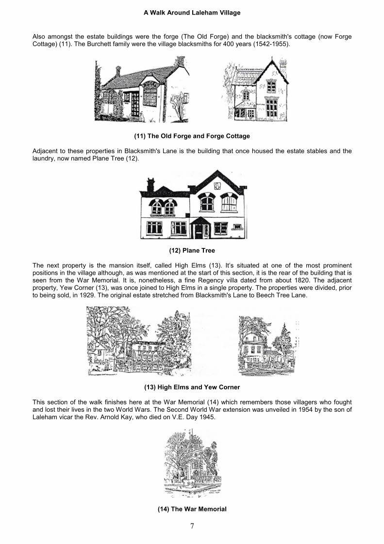
Also amongst the estate buildings were the forge (The Old Forge) and the blacksmith's cottage (now Forge Cottage) (11). The Burchett family were the village blacksmiths for 400 years (1542-1955).
(11) The Old Forge and Forge Cottage Adjacent to these properties in Blacksmith's Lane is the building that once housed the estate stables and the laundry, now named Plane Tree (12).
(12) Plane Tree The next property is the mansion itself, called High Elms (13). It’s situated at one of the most prominent positions in the village although, as was mentioned at the start of this section, it is the rear of the building that is seen from the War Memorial. It is, nonetheless, a fine Regency villa dated from about 1820. The adjacent property, Yew Corner (13), was once joined to High Elms in a single property. The properties were divided, prior to being sold, in 1929. The original estate stretched from Blacksmith's Lane to Beech Tree Lane.
(13) High Elms and Yew Corner This section of the walk finishes here at the War Memorial (14) which remembers those villagers who fought and lost their lives in the two World Wars. The Second World War extension was unveiled in 1954 by the son of Laleham vicar the Rev. Arnold Kay, who died on V.E. Day 1945.
(14) The War Memorial

A Walk Around Laleham Village
8
Section 3 - Vicarage Lane / Ferry Lane / Laleham Abbey (35+ minutes) From the War Memorial walk along Shepperton Road towards Vicarage Lane, passing the gable end of Barn Cottage, which was converted from the barn of Old Farm (16). Look across Shepperton Road from the corner of Vicarage Lane; to the left is the lych-gate of All Saints Church (a memorial to a Mr Thornton of Vicarage Lane who died in 1908). To the right of this is Thorobred Cars. These buildings have previously housed a bakery and a Post Office, and the extensive workshop area behind was once stabling for a horse and cab service before becoming a garage in the 1920s. Adjacent to the garage are The Old Cottage (18th Century with axial chimneys) and Dial House (15). The latter is a fine three-storey Queen Anne house with a sundial (dated 1730) blocking one of its central windows. Inside it has fine panelled rooms.
(15) Dial House Walk down Vicarage Lane towards the river. On the left side of the road there was once a high wall against which peaches were grown, together with a large vine which produced black grapes. In the first decade of the 20th century the wall was demolished, making way for a shop and 15 houses. Towards the end of the lane, on the right, are Old Farm (16) and the adjoining cottages, called Riverside. Their roof is of Queen Post construction and is certainly older than the buildings below, which are of 18th Century type. Perhaps a barn was rebuilt as houses using the original roof? Old Farm was the home of the Honnor family from the mid 17th Century until 1941.
(16) Old Farm Next to Riverside is Little Ravenswell (17), which backs onto Town Quay. It is a fine example of a small Queen Anne brick house with a dentilled wooden cornice at the eaves and a projecting wooden hood over the doorway. This leads straight into the ‘hearth room’, where the cooking used to be done. It has a semi-circular staircase round a newel post and a central chimney. The house has many Georgian features such as corner hearths with duck-egg fire baskets.
(17) Little Ravenswell

A Walk Around Laleham Village
9
Continue down Vicarage Lane, turning left at the river along Thameside towards Ferry Lane. On the left you will pass Condor Road (formerly Cheese Lane) which was the locality of the former Lord of the Manor's Mansion house. Adjacent to this, on the river bank, was once The Greyhound public house, much used in the 18th Century for meetings of the Court Leet, as well as it being a favourite drinking place for the bargees and other river users. You will also pass The Barn, an unusual house built by Sir Edward Maufe in 1909 for the musical comedy star Marie Studholme. It was named after one of her hit songs, "The Little Dutch Barn". When you reach the junction of Thames Side and Ferry Lane you can see the small slipway that the ferry used up until the retirement of George Knight in 1972, after 36 years as ferryman at Laleham. The ferry was mostly used by visitors to Laleham Golf Club (founded in 1903) which is situated on the Surrey bank of the Thames. An amusing history of the club can be read in ‘Our Dear Laleham. Walk on past some beautiful willows (reduced in number during the storm of 1987) and past the riverbank habitat of local wildfowl and then cross to the public car park. Take the well trodden paths up into Laleham Park that are alongside either Burway Rowing Club or the adjoining school rowing club. For a longer walk of a further 1.5km each way, continue downstream along the riverside, passing Burway Rowing Club, Surrey Canoe Club and the campsite to Chertsey Lock and Bridge (built 1780), and The Kingfisher public house. An alternative return route is through Laleham Park, accessed shortly after returning under the motorway flyover. On reaching the road, Abbey Drive, you’ll see the gates of Laleham Abbey (formerly Laleham House) on the right. Laleham House (18) was built by John Buonarotti Papworth (architect to the Prince Regent) in 1805 for the Second Earl of Lucan. It stands in 83 acres of parkland and has an imposing neo-classical style with a Greek Doric porch. The interior has marble floors and pillars, a beautiful semi-circular staircase and a cupola. After the 5th Earl had sold the house in 1928 it was used by the nuns of the Community of St Peter (hence the current title ‘Abbey’). In 1981 it was sold and redeveloped into multiple properties and is now a private estate.
(18) Laleham House/Abbey Turn left along Abbey Drive, towards Ferry Lane. Opposite the horse paddock in Abbey Drive is The Thatched Cottage (19), once the Lucan Estate Lodge and built around the same time as Laleham House (1807). It is a charming example of a ‘Cottage Orné’ with ornate barge boards, a thatched roof and veranda supported on rustic posts, ornamental chimney stacks and cast iron windows with a lattice design.
(19) Thatched Cottage

A Walk Around Laleham Village
10
The Coverts (20) is the next house of historical significance that you pass on your way to the junction with Ferry Lane. It is a fine example of an early 18th Century symmetrical house with a parapet surrounding three roofs. The elegant front door with its Doric pilasters is reached by a flight of stone steps and above the windows are flat arches of rubbed bricks which were fashionable at the time. The original kitchens are in the basement.
(20) The Coverts On the left, immediately beyond Moorhayes Drive, is Muncaster House (21) (formerly Moorhayes House), an early 18th Century stuccoed building with a parapet and pilasters, two wings at the rear, a fine tile roof and late 19th Century additions. It was famous nationwide in the early 19th Century as the first preparatory school in the country; founded by the Rev. John Buckland when he and his brother-in-law, the Rev. Thomas Arnold, settled in Laleham. The house later became a hotel and is now divided into flats.
(21) Muncaster House Walk up Ferry Lane towards the village centre. The area behind the remaining high walls on the left was once Daisy Field. Later parts of these listed walls are remains from the Lord of the Manor's land, which covered the area down to the riverside. On the death of the Earl of Lonsdale in 1803 the Manor, and much of Laleham, was bought by Lord Lucan, who built his new house in Laleham Park. Facing the junction of Ferry Lane and Shepperton Road are the last of the villages original shop buildings (22), which currently trade as a vets and as a hair salon.
(22) The Shops

A Walk Around Laleham Village
11
Alongside the shops is the oldest public house in the village, The Three Horseshoes (23). A building is shown on this site on John Norden's map of 1623, and part of the present building is known to have been used as an inn in 1624. In the 18th Century it was acquired as part of the Manor of Laleham by Sir James Lowther and was sold by auction a year after his death in 1802. There were numerous licensees over the years including William Clifton who ran the pub for 37 years (1886-1923).
(23) Three Horseshoes Public House From here you are again in sight of the War Memorial, to your left. In a further detour to the right, of interest to horticulturalists, and a short distance along Shepperton Road at the edge of the village, are the walls of what is now the council nursery. A row of fireplaces are built into the wall (No 24 on the village plan, page 2). These were once lit during cool periods of the summer months to help ripen the fruit in the adjoining orchard. Laleham's listed buildings In the 1950s Building Preservation Orders were introduced to safeguard our country's heritage. Statutory lists giving legal protection to buildings and structures considered to be of special architectural or historic interest were provided for Local Authorities, who had to ensure that the legal requirements affecting ’listed buildings’ in their area were observed. Laleham has 26 listed buildings and structures, most of which have been mentioned and illustrated in these pages. Grade I
All Saints Church Chertsey Bridge
Grade II Abbey Drive: Ferry Lane:
Laleham House Muncaster House Abbey Mews Shepperton Road: The Coverts Dial House The Thatched Cottage Dial House Garden
The Broadway: Staines Road: Church Farmhouse The Corner House High Elms Vicarage Lane: Yew Corner Old Farm Wisteria Cottage Riverside The Turk's Head Public House Little Ravenswell Cambridge Cottage Red Cottage Manor Farmhouse
In addition the following are also listed:
The boundary wall of Yew Corner on Staines Road Outbuildings adjacent to Manor Farmhouse and Barn Outbuildings to northeast of the Barn at Manor Farm The City Post at southeast of Chertsey Bridge The City Post 200 yards north of Chertsey Lock