Embed Size (px)
Citation preview

A WEB-BASED APPLICATION FOR REAL-TIME GIS
O. Ozdilek a, *, D. Z. Seker a
a ITU, Civil Engineering Faculty, 80626 Maslak Istanbul, Turkey - (ozdilek, seker)@itu.edu.tr
KEY WORDS: Spatial Information Sciences, GIS, Internet/Web, Real-time, Data mining, Data Structures, Decision Support, Open
Systems ABSTRACT: Weather plays a significant role in the operation of various facilities and industries in the world. Nowadays, there are many sources of weather data maps and tables. Naturally, there are many information systems created to manage and to manipulate weather-based data. The function of an information system is to improve one’s ability to make decisions. An information system relates to a chain of operations lead to planning the observation and collection of data, to storage and analysis of data, to the use of derived information in decision-making processes. The creation of a GIS database almost always represents the most significant investment in a GIS project. Therefore, data management becomes the most important part of GIS. Various data structures and exchanging different types of data cause serious problems at the beginning phase of GIS. Recently, web-based GIS with the rapid expansion of internet and the World Wide Web is regarded as one of important issues for web application, and several GIS products running on web browser have been announced. The system used in this study has two main differences from other web-based GIS applications. It is real-time and gets data from sources simultaneously in exact time intervals that users defined previously, and secondly, all the developing and publishing tools used in the system are open sourced. Aim of this study is to create a web-based, free and open sourced GIS that can work with different data formats by exchanging and presenting data as a real-time map on web.
* Corresponding author.
1. INTRODUCTION
Information technologies have gained importance in the worldwide organizations due to their efficiency with low costs. Naturally, developments in computer and information systems, especially data management systems, directly affect GIS. Data management is the most important part of GIS. Various data structures and exchanging different types of data cause serious problems at the beginning phase of GIS. Although organizations and individuals involved with GIS have developed many different solutions, data exchange still remains as one of the main problems. However, development of computers and data systems linked with some problems, they also have opened new perspectives of creating and managing data systems easily and economically. Furthermore, expansion of the computer systems and advances in internet related technologies extend GIS in a new horizon. Due to development of the internet technologies; collecting data, delivering materials (maps), manipulating and updating data becomes easier. The recent technologies provide lots of tools for spatial technologies and data modelling. As weather is the statement of the physical conditions at an instant, forecasting is of concern to one and all living bodies over the earth. As such, time immemorial weather forecasting is a subject of great concern for the physical scientists (Saseendran, 2003). Most of the organizations like transportation, agriculture, water and emergency management need specific weather requirements. Various methods were developed and used by scientists to observe, and monitor weather-related information. Development of information systems, especially GIS, bring out new solutions for managing and monitoring weather-related data. Monitoring weather conditions within a GIS is now relatively an easy task. The use of GIS technology is necessary because information about the
structure and development of it cannot be derived without careful examination of spatial and temporal relations of weather data. Distinguished from the other information technologies, GIS offers a set of functions to analyze and relate spatial data. During converting information into GIS, analysis tools can be used to solve more complex business problems. Support of real-time maintenance of geographic related data and the distribution of updates to all relevant groups within an organization in timely manner is realized. This improved access to current data increases the overall effectiveness of information users. With the right weather information delivered at the right time, many business leaders could make profitable decisions (Vadlapudi, 2003). Therefore, combining real-time and weather information has very significant potential for improving weather-related decision support systems. GIS offers much more than a typical “display” of weather graphics, and provides the capability of combining the weather data itself with virtually any other geographically based information, and make it possible to calculate meaningful value-added results (Sznaider, 2004). 1.1 Objectives of the Study
The objective of this study is to create a weather processing system by integrating weather data with different structures collected from different sources in various formats, in a web-based real-time GIS. The detailed objectives are:
• Integration of weather data in a GIS, • Creating a web-based system, • Creating a real-time system, • Creating an open-sourced system, • Capable data structure that recognize different raw
data formats,

• Creating a data processing system that exchange different data formats into one format,
• Creating an Interactive web-map on the fly with the processed data,
• Creating a reporting system that produces reports based on user specified parameters.
The benefits of having such a system are;
• Reducing monitoring costs, • Improving the speed of decision making by
supporting the decision-makers with real time information,
• Ability to access by everyone and everywhere over the internet,
• Reducing time and minimizing effort to reach data, • High speed, security and high rate of error handling
with new internet technologies, • Centralized database that provides a single source of
common information providing standardization, and faster retrieval and selective modification of information (Montgomery, 1993),
• Ability to produce reports based on user specified parameters.
2. METHODOLOGY AND THE DATA USED
2.1 The Study Area
The study area covers all the provinces of Turkey. Data collected from 1038 meteorological stations located in 81 provinces and 957 districts where weather data, have been collected and recorded since 1929 (Figure 1).
Figure 1. The Study Area (location of the meteorological
stations) 2.2 Materials and Methods
2.2.1 Data Used: The data used in the system can be grouped according to their sources. The data obtained the meteorological stations as given include (Figure 2);
• Data structure information, • Station identification,
• Data time information, • Meteorological information.
The data reserved by the server consist of;
• Province information, • District information, • Station information with:
� Station coordinate, � Station administrator information, � Station data type information.
The data used in the system can also be grouped by its contents as weather related and non-weather related data. Weather data used in the system consist of:
• Surface temperature information, • Surface wind information, • Rainfall data.
Non-weather data used in the system include;
• Province information, • District information, • Station information with: • Data time information.
Figure 2. An Example for Station-Based Data Formats 2.3 Technology Used
Like most of the internet applications, web-based GIS are based on the simple server/client model. In a server/client system a computer acts as a client that sends requests to the server computer, the server computer processes the requests, and then sends the results back to the client (Kim, 1998). 2.3.1 Server Side Software: There are many possible ways when constructing a web-based map system, the main determiner for the project is the technologies that will be used. Investigating proper programming languages and web technologies, the options are narrowed down to scripting
languages and widely used web data presentation systems in order to increase capability. The aim while selecting scripting languages for programming; protection of the open source nature of the project and relatively easily development cycle must be provided. The criteria used while selecting the programming language;
• The programming interfaces must provide reaching web services,
• The programming interfaces must provide database management,
• Relatively rapid executive code must be used.
The available programming languages such as PHP, Perl, Python, Tcl/Tk for similar works which support the mentioned rules above are widely used ones. Perl and Python seemed as good alternatives because of extensive library support and using advances of UNIX systems. But Perl had a cryptic syntax and Python is not built for managing web services. PHP is widely used general purpose scripting language that is especially suited for web development (PHP.net, 2004). PHP can be embedded to (X)HTML or XML. PHP is a tool for creating dynamic data-driven web-pages. As a result, PHP programming system has been selected for managing the data system (Listing 1). <html> <head> <title>Example</title> </head> <body> <?php echo "Hi, I'm a PHP script!"; ?> </body> </html>
Listing 1. PHP Script Example
The presentation of data is also important in the project. The presentation system has to be;
• Suitable for map presentation, • Provide interactivity (response to mouse events) and
animations, • Suitable for open source development, • Support scripting, • Integrated with other web standards easily.
SVG has been selected for this application because it fits the criteria stated above and the project needs the best filled criteria. After determining the main programming tools, a database system should be chosen that could provide an easy integration with PHP. The chosen database system must be compatible with open-source coding. The result is MySQL. The Apache httpd server was chosen with similar reasons. Moreover PHPmyAdmin, which is also open-sourced, used to reach MySQL database over web browser. SVG is a language for describing the two dimensional graphics in XML (Adobe.com, 2004). SVG allows three types of graphic objects: vector graphics shapes, images and text. Graphical
objects can be grouped, styled by styling sheets, transformed and compositioned into the previously rendered objects. SVG drawings can be interactive or dynamic. Animations can be defined and triggered either declaratively or via scripting. Because of its compability and leveraging of the other web standards features like scripting can be done on XHTML and SVG elements simultaneously within the same page (Listing 2). <?xml version="1.0" encoding="ISO-8859-1"standalone="no"?> <defs> <circle cx="150" cy="120" r="80"/> </defs> <title>SVG </title> <text x="20" y="30" style="fill: #000; font-size:24px">Element clipPath</text> <rect x="30" y="100" width="350" height="80" style="fill: #FFC; stroke: #00C; stroke-width: 1.5px"/> </g> </svg>
Listing 2. Example for a SVG file
2.3.2 Client Side Software: A SVG compatible viewer should be installed at the client side. 2.3.3 Methodology:
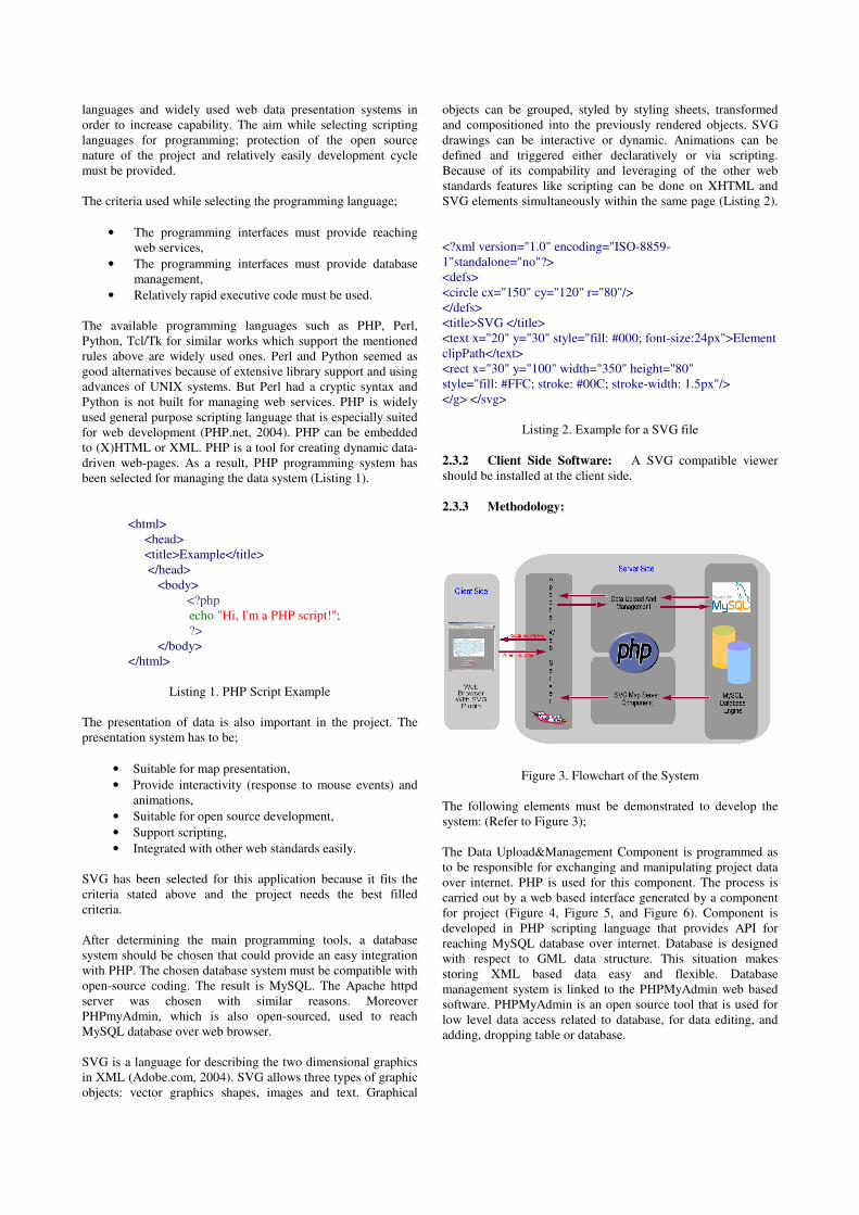
Figure 3. Flowchart of the System
The following elements must be demonstrated to develop the system: (Refer to Figure 3); The Data Upload&Management Component is programmed as to be responsible for exchanging and manipulating project data over internet. PHP is used for this component. The process is carried out by a web based interface generated by a component for project (Figure 4, Figure 5, and Figure 6). Component is developed in PHP scripting language that provides API for reaching MySQL database over internet. Database is designed with respect to GML data structure. This situation makes storing XML based data easy and flexible. Database management system is linked to the PHPMyAdmin web based software. PHPMyAdmin is an open source tool that is used for low level data access related to database, for data editing, and adding, dropping table or database.

Figure 4. Upload Manager Main Window: Data Upload Type Selector
Figure 5. Upload Manager: Upload text file menu
Figure 6. Upload Manager: Completing uploading data The SVG Map Server Component is programmed to generate SVG images from the database and add them basic interactivity that can be triggered by programmed UI elements in JavaScript or other script languages. Map server component is a set of PHP scripts capable of reaching constructed database structure and generating SVG images from the data stored in database. Map Server generates maps on the web pages on the fly.
Data Conversation Component is responsible for the conversation of different data formats. PHP is widely used for this component.
3. RESULTS
Since the weather changes are one of the major variables for all living bodies, its monitoring is vital for the decision-makers. Therefore, decision-makers need the best and fastest information to prepare severe weather events. As a result of this project, which is still its development phase and should be worked on, developed application can support decision makers with two materials;
• Weather information reports in PDF format (Figure 7),
• SVG based real-time weather maps (Figure 8 and Figure 9),
Figure 7. Weather Information Reports in PDF Format
Figure 8. SVG Based Weather Map

Figure 9. SVG Based Weather Map
Moreover, following results are reached as a conclusion of project;
• SVG format is capable for producing and publishing real-time maps on the web,
• Real-time information can be collected, processed and presented easily by the help of web-technologies,
• Web-technologies makes the system flexible, therefore system can be converted to monitoring another environmental events which demands real-time monitoring like earthquakes or pollution,
• Open sourced software is necessary for development of web-mapping.
4. CONCLUSION
Integrating real-time weather information into a web-based GIS system can provide decision-makers with the best weather information in the shortest time. Therefore, decision-makers get prepared to make better and faster decisions which can reduce the damage of the natural events and minimize the loss. System designed in this study can easily be expanded and integrated to other systems because of its structure and flexibility. It can easily be transformed into other systems which has different purpose. For example; system designed in this study can easily be transformed to an earthquake monitoring system by making minor modifications to its database management system. These features make web-based GIS applications as incredible developments of open sourced web tools provide web based applications.
5. REFERENCES
Kim, K..S Lee, K.W, 1998 “The Development of Web-based geographic information system”, Pascolo, P. Brebbia, C.A, ed. GIS Technologies and Their Environmental Applications, WIT Press, UK Montgomery, G.E. , Schuch, H.C , 1993. GIS data Conversion Handbook, GIS World, Inc, Fort Collins. Adobe.com, 2004. ”What is SVG?”, http://www.adobe.com/svg (accessed May 2004) PHP.net, 2004, “What is PHP”, http://www.php.net, (accessed May 2004) Saseendran S. A., Harenduprakash L., Rathore L. S. and Singh S. V, 2003.” A GIS application for weather analysis and forecasting”, http://www.gisdevelopment.net/application/miscellaneous/misc015pf.htm (accessed May 2004) Sznaider, R.” Real-Time International Weather Data in GIS Formats“, http://gis.esri.com/library/userconf/proc00/professional/papers/PAP334/p334.htm (accessed May 2004) Vadlapudi, S., 2003. ”Development of Weather Processing System by Integrating Weather Data into GIS”, http://www.gisdevelopment.net/application/environment/climate/ma03190abs.htm (accessed May 2004)