Embed Size (px)
Citation preview
AAIB Bulletin S1/2019SPECIAL
Farnborough HouseBerkshire Copse RoadAldershot, Hants GU11 2HH
Tel: 01252 510300Fax: 01252 376999www.aaib.gov.uk
This Special Bulletin contains facts which have been determined up to the time of issue. It is published to inform the aviation industry and the public of the general circumstances of accidents and serious incidents and should be regarded as tentative and subject to alteration or correction if additional evidence becomes available.
© Crown copyright 2019
ACCIDENT
Aircraft Type and Registration: Piper PA-46-310P Malibu, N264DB
No & Type of Engines: 1 Teledyne Continental TSIO-520-BE engine Year of Manufacture: 1984 (Serial no: 46-8408037)
Date & Time (UTC): 21 January 2019 at 2016 hrs
Location: 22 nm north-north-west of Guernsey Type of Flight: Unknown Persons on Board: Crew - 1 Passengers - 1
Injuries: Crew - 1 (Missing) Passengers - 1 (Fatal)
Nature of Damage: Aircraft destroyed
Commander’s Licence: Private Pilot’s Licence
Commander’s Age: 59 years
Commander’s Flying Experience: Approximately 3,700 hours Last 90 days - unknown Last 28 days - unknown
Information Source: AAIB Field Investigation
Introduction
At 2122 hrs on 21 January 2019, the AAIB was informed that a Piper PA-46-310P Malibu aircraft, registration N264DB, had been lost from radar in transit from Nantes, France, to Cardiff in the UK, and that a surface search for survivors was underway using assets from the Channel Islands, UK and France. The wreckage of the aircraft had not been located by the time the official search ended at 1515 hrs on 24 January 2019, and the event therefore became classed as an aircraft accident under the terms of Annex 13 to the Convention on International Civil Aviation1. There were two persons on board the aircraft but neither was found by the surface search.
Footnote1 Annex 13 contains International Standards and Recommended Practices for Aircraft Accident and Incident Investigation.
AAIB Special Bulletin: S1/2019 N264DB EW/C2019/01/03
2© Crown copyright 2019
The aircraft was lost in international waters and, in such circumstances, Annex 13 places a responsibility on the State of Registration of the aircraft, in this case the USA as represented by the National Transportation Safety Board (NTSB), to commence an investigation. However, the State of Registration may, by mutual agreement, delegate the investigation to another State. On 22 January 2019, in anticipation that an accident investigation would be required, the NTSB delegated responsibility for the investigation to the State of the Operator, in this case the UK as represented by the AAIB.
The AAIB began an investigation assisted by the Bureau d’Enquêtes et d’Analyses pour la Sécurité de l’Aviation Civile (BEA) in France, which had been supporting search activities since the accident occurred, the NTSB in the USA, and the Junta de Investigación de Accidentes de Aviación Civil (JIAAC) in Argentina.
This Special Bulletin contains preliminary factual information on the investigation and general information about how aircraft registered in the USA may be operated between the UK and France.
History of the flight
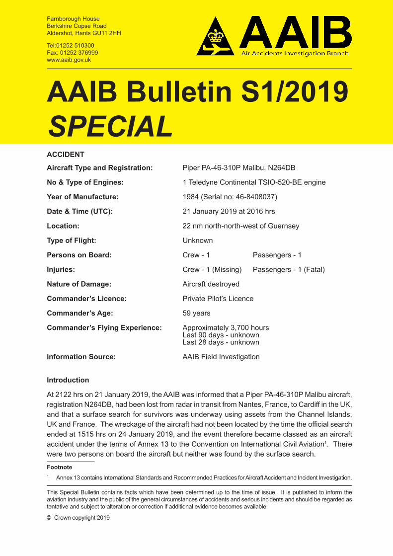
The pilot of N264DB flew the aircraft and a passenger from Cardiff Airport to Nantes Airport on 19 January 2019 with a return flight scheduled for 21 January 2019. The pilot arrived at the airport in Nantes at 1246 hrs on 21 January to refuel and prepare the aircraft for the flight. At 1836 hrs the passenger arrived at airport security, and the aircraft taxied out for departure at 1906 hrs. Figure 1 shows the aircraft on the ground before departure.
Figure 1
N264DB on the ground at Nantes prior to the flight
3
AAIB Special Bulletin: S1/2019 N264DB EW/C2019/01/03
© Crown copyright 2019
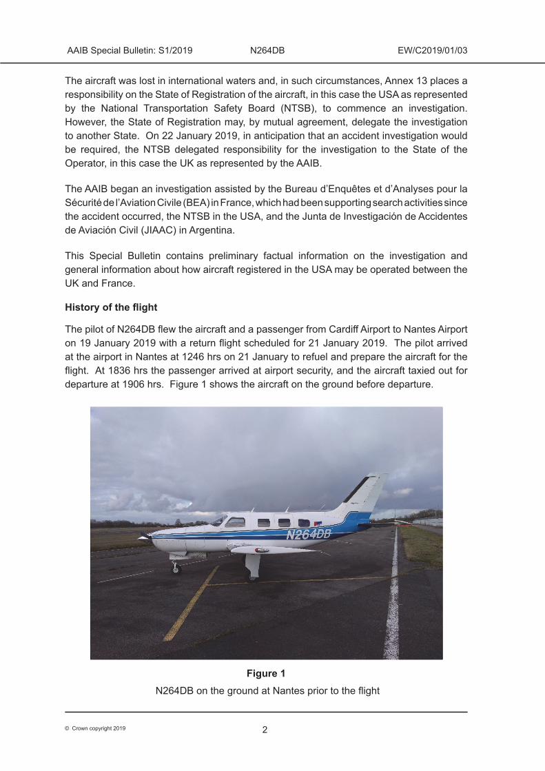
The pilot’s planned route would take the aircraft on an almost direct track from Nantes to Cardiff, flying overhead Guernsey en route (Figure 2). The Visual Flight Rules (VFR) flight plan indicated a cruise altitude of 6,000 ft amsl2 and a distance of 265 nm.
Figure 2
Planned route from Nantes to Cardiff
The aircraft took off from Runway 03 at Nantes Airport at 1915 hrs, and the pilot asked ATC for clearance to climb to 5,500 ft. The climb was approved by Nantes Approach Control and the flight plan was activated.
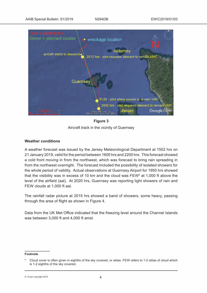
The aircraft flew on its planned route towards Cardiff until it was approximately 13 nm south of Guernsey when the pilot requested and was given a descent to remain in Visual Meteorological Conditions (VMC)3. Figure 3 shows the aircraft’s subsequent track. The last radio contact with the aircraft was with Jersey Radar at 2012 hrs, when the pilot asked for a further descent. The aircraft’s last recorded secondary radar point was at 2016:34 hrs, although two further primary returns were recorded after this4. The wreckage of N264DB was subsequently found on the seabed about 30 metres from the position of the last secondary radar point recorded by the radar at Guernsey.
Footnote2 amsl: above mean sea level.3 Pilots must remain in VMC to continue flight under Visual Flight Rules, the rules under which this flight
was undertaken. The aircraft was in Class D airspace and so the pilot was required to remain 1,500 m horizontally and 1,000 ft vertically clear of cloud, and have an in-flight visibility greater than 5,000 m.
4 See later section, Recorded information, for an explanation of the radar data.
4
AAIB Special Bulletin: S1/2019 N264DB EW/C2019/01/03
© Crown copyright 2019
Figure 3Aircraft track in the vicinity of Guernsey
Weather conditions
A weather forecast was issued by the Jersey Meteorological Department at 1502 hrs on 21 January 2019, valid for the period between 1600 hrs and 2200 hrs. This forecast showed a cold front moving in from the northwest, which was forecast to bring rain spreading in from the northwest overnight. The forecast included the possibility of isolated showers for the whole period of validity. Actual observations at Guernsey Airport for 1950 hrs showed that the visibility was in excess of 10 km and the cloud was FEW5 at 1,000 ft above the level of the airfield (aal). At 2020 hrs, Guernsey was reporting light showers of rain and FEW clouds at 1,000 ft aal.
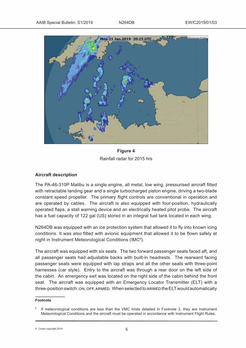
The rainfall radar picture at 2015 hrs showed a band of showers, some heavy, passing through the area of flight as shown in Figure 4.
Data from the UK Met Office indicated that the freezing level around the Channel Islands was between 3,000 ft and 4,000 ft amsl.
Footnote5 Cloud cover is often given in eighths of the sky covered, or oktas. FEW refers to 1-2 oktas of cloud which
is 1-2 eighths of the sky covered.
5
AAIB Special Bulletin: S1/2019 N264DB EW/C2019/01/03
© Crown copyright 2019
Figure 4Rainfall radar for 2015 hrs
Aircraft description
The PA-46-310P Malibu is a single engine, all metal, low wing, pressurised aircraft fitted with retractable landing gear and a single turbocharged piston engine, driving a two-blade constant speed propeller. The primary flight controls are conventional in operation and are operated by cables. The aircraft is also equipped with four-position, hydraulically operated flaps, a stall warning device and an electrically heated pitot probe. The aircraft has a fuel capacity of 122 gal (US) stored in an integral fuel tank located in each wing.
N264DB was equipped with an ice protection system that allowed it to fly into known icing conditions. It was also fitted with avionic equipment that allowed it to be flown safely at night in Instrument Meteorological Conditions (IMC6).
The aircraft was equipped with six seats. The two forward passenger seats faced aft, and all passenger seats had adjustable backs with built-in headrests. The rearward facing passenger seats were equipped with lap straps and all the other seats with three-point harnesses (car style). Entry to the aircraft was through a rear door on the left side of the cabin. An emergency exit was located on the right side of the cabin behind the front seat. The aircraft was equipped with an Emergency Locator Transmitter (ELT) with a three-position switch: on, off, armed. When selected to armed the ELT would automatically
Footnote
6 If meteorological conditions are less than the VMC limits detailed in Footnote 3, they are Instrument Meteorological Conditions and the aircraft must be operated in accordance with Instrument Flight Rules.
6
AAIB Special Bulletin: S1/2019 N264DB EW/C2019/01/03
© Crown copyright 2019
start to transmit when it detected an impact. ELT transmissions cannot be detected underwater. The aircraft was also equipped with life jackets for each occupant and a six-man life raft, kept in the rear baggage compartment and accessible from the cabin.
Aircraft history and maintenance
N264DB was manufactured in 1984, and on 30 November 2018 the airframe had flown 6,636 hrs and the engine had operated for 1,195 hrs since overhaul. The Certificate of Registration was issued on 11 September 2015 and had an expiry date of 30 September 2021. The Airworthiness Certificate was dated 27 April 1984. This certificate remains valid if aircraft maintenance has been performed in accordance with Federal Aviation Regulations (FAR) Parts 21, 43 and 91. The last significant maintenance was an Annual / 100-hour maintenance that was completed on 30 November 2018; the Certificate of Release to Service was signed by the holder of a Federal Aviation Administration (FAA) Inspector Authorization (IA).
Underwater search
Background
Following an aircraft accident at sea, an underwater search operation may be undertaken by the Safety Investigation Authority (SIA) leading an investigation to locate and gather evidence which may establish the cause of the accident. The decision to conduct an underwater search is determined on a case-by-case basis and a search would only be carried out if it was considered safe and practical to do so. The aim of a search would be to determine the location of the wreckage and to undertake an underwater survey; wreckage would only be recovered if it was considered feasible and necessary in order to understand the cause of the accident.
Probable location of the wreckage
The AAIB established the most likely location for where the aircraft struck the surface of the sea by analysing radar data and the flight profile during the final minutes of the flight. The Ministry of Defence’s Salvage and Marine Operations (SALMO) Project Team then factored in the depth of water and tidal flow to determine the primary area for the seabed search, which was an area of 4 nm2 approximately 22 nm north-northwest of Guernsey.
Coordination of the seabed search
Through SALMO, the AAIB contracted a specialist survey vessel, the Geo Ocean III, to undertake an underwater survey of the seabed to try to locate and identify wreckage from the aircraft. The AAIB was aware that a separate, privately funded search was to be conducted and established close liaison with those involved to maximise the chance of locating any wreckage and to ensure a safe search operation. The privately contracted vessel was the FPV Morven.
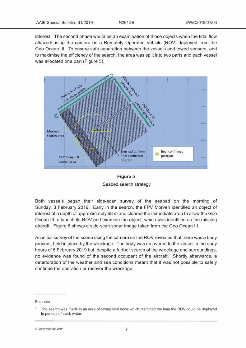
The search was planned to be conducted in two phases. The first phase would be a survey of the seabed by both vessels using towed side-scan sonar to identify objects of
7
AAIB Special Bulletin: S1/2019 N264DB EW/C2019/01/03
© Crown copyright 2019
interest. The second phase would be an examination of those objects when the tidal flow allowed7 using the camera on a Remotely Operated Vehicle (ROV) deployed from the Geo Ocean III. To ensure safe separation between the vessels and towed sensors, and to maximise the efficiency of the search, the area was split into two parts and each vessel was allocated one part (Figure 5).
Figure 5 Seabed search strategy
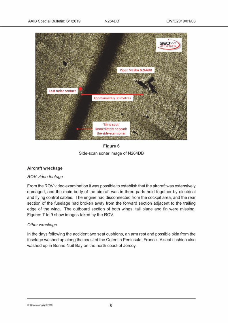
Both vessels began their side-scan survey of the seabed on the morning of Sunday, 3 February 2019. Early in the search, the FPV Morven identified an object of interest at a depth of approximately 68 m and cleared the immediate area to allow the Geo Ocean III to launch its ROV and examine the object, which was identified as the missing aircraft. Figure 6 shows a side-scan sonar image taken from the Geo Ocean III.
An initial survey of the scene using the camera on the ROV revealed that there was a body present, held in place by the wreckage. The body was recovered to the vessel in the early hours of 6 February 2019 but, despite a further search of the wreckage and surroundings, no evidence was found of the second occupant of the aircraft. Shortly afterwards, a deterioration of the weather and sea conditions meant that it was not possible to safely continue the operation or recover the wreckage.
Footnote7 The search was made in an area of strong tidal flows which restricted the time the ROV could be deployed
to periods of slack water.
8
AAIB Special Bulletin: S1/2019 N264DB EW/C2019/01/03
© Crown copyright 2019
Figure 6Side-scan sonar image of N264DB
Aircraft wreckage
ROV video footage
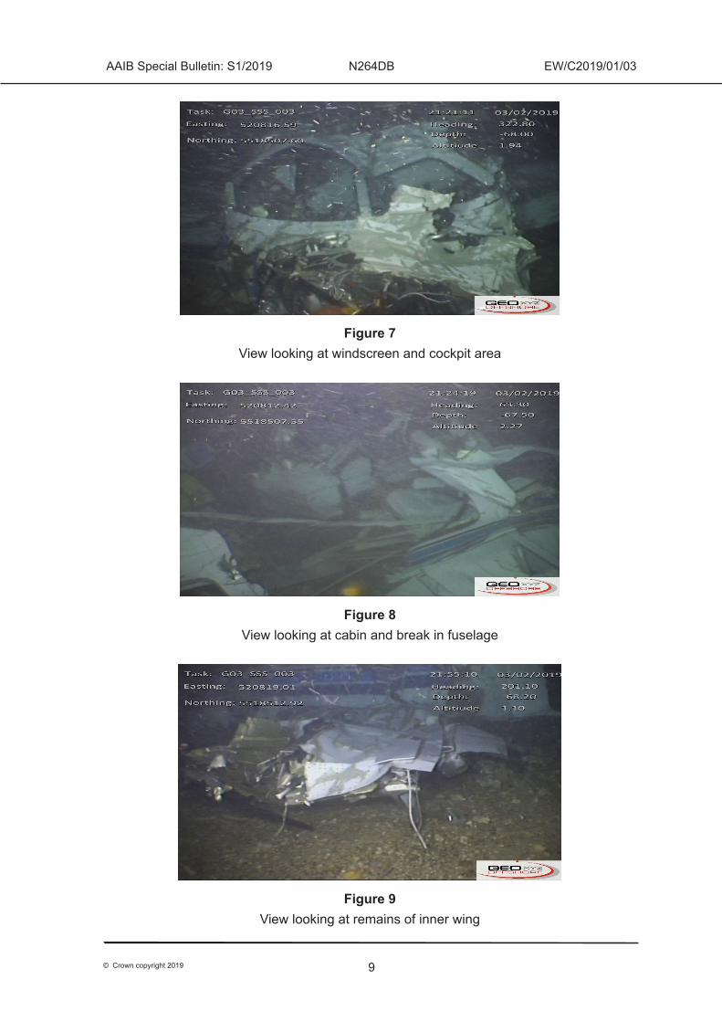
From the ROV video examination it was possible to establish that the aircraft was extensively damaged, and the main body of the aircraft was in three parts held together by electrical and flying control cables. The engine had disconnected from the cockpit area, and the rear section of the fuselage had broken away from the forward section adjacent to the trailing edge of the wing. The outboard section of both wings, tail plane and fin were missing. Figures 7 to 9 show images taken by the ROV.
Other wreckage
In the days following the accident two seat cushions, an arm rest and possible skin from the fuselage washed up along the coast of the Cotentin Peninsula, France. A seat cushion also washed up in Bonne Nuit Bay on the north coast of Jersey.
9
AAIB Special Bulletin: S1/2019 N264DB EW/C2019/01/03
© Crown copyright 2019
Figure 7 View looking at windscreen and cockpit area
Figure 8View looking at cabin and break in fuselage
Figure 9 View looking at remains of inner wing
10
AAIB Special Bulletin: S1/2019 N264DB EW/C2019/01/03
© Crown copyright 2019
Recorded information
Sources of recorded information
Recorded radar information (primary, and secondary Mode A and C8) was available from separate ground-based sites in Guernsey, Jersey and France. The radar data provided an almost complete record of the accident flight, starting as the aircraft took off and ending shortly before it struck the sea. The radar tracks from the different sites predominantly aligned, corroborating the relative accuracy of the independent data sources.
Recordings of RTF communications between the pilot and ATC were available and included the last radio transmission.
The pilot used a flight planning and navigation software application installed on his portable tablet computer to create a route between Nantes and Cardiff and file the VFR flight plan. This information had been uploaded to the pilot’s cloud account9. During flight the tablet computer displays the aircraft position and planned route overlaid on a moving map, and records GPS-derived position information. The pilot’s tablet computer was not found within the wreckage.
The aircraft was not fitted with an accident-protected flight data recorder or cockpit voice recorder and was not required to be.
Information from the recorded data
All times are UTC, and altitude is derived from Mode C data (transmitted in 100 ft increments with a tolerance of ±50 ft), corrected for local atmospheric pressure (QNH)10.
After departure from Nantes, N264DB climbed progressively to 5,500 ft and its average ground speed was about 170 kt, equivalent to an estimated airspeed of 169 kt TAS based on a calculated wind from 250° at 25 kt. When the aircraft was about 20 nm south of Jersey, the pilot was transferred to the Jersey Control frequency.
On initial contact with Jersey ATC, the aircraft was cleared to enter controlled airspace and maintain FL5511, following which the pilot was asked to advise ATC if at any time he would not be able to “maintain vmc”; this was to enable ATC coordination with other aircraft in the area should it be necessary for N264DB to descend or climb. At 1958 hrs, the controller asked the pilot to check if the aircraft’s altimeter pressure setting was correctly set to 1013 hPa, because the information on the radar indicated FL53. The pilot acknowledged
Footnote8 Mode A refers to the four-digit ‘squawk’ code set on the transponder, and Mode C refers to the aircraft’s
pressure altitude which is transmitted in 100 ft increments. Secondary radar typically provides greater accuracy than primary radar.
9 Cloud account refers to storage of data which is hosted remotely and made available to a user over a network (typically the Internet).
10 Transmitted Mode C values are based on a standard pressure setting (see next footnote). This report has adjusted those values to reflect the local atmospheric pressure (QNH) so that they indicate altitude ie the vertical distance above mean sea level.
11 Flight Levels (FL) are referenced to the International Standard Atmosphere (ISA) setting of 1013 hPa. FL55 is equivalent to 5,500 ft based on the standard pressure setting.
11
AAIB Special Bulletin: S1/2019 N264DB EW/C2019/01/03
© Crown copyright 2019
and, shortly afterwards, the aircraft climbed to FL55; the aircraft was about 11 nm south-west of Jersey.
At 2002:10 hrs, N264DB was about 11 nm west of Jersey and 13 nm south of Guernsey when the pilot requested clearance to descend to “maintain vmc” (Figure 3). The aircraft was cleared to FL50, with the instruction to advise ATC if a further descent was required. Shortly afterwards, the aircraft began to descend whilst also making a right turn followed by a left turn. This positioned the aircraft overhead Guernsey, about 1.5 nm parallel to the planned track. The controller then inquired if N264DB required a further descent, to which the pilot responded: “negative, just avoided a patch there, but back on heading five thousand feet”.
At 2012 hrs, N264DB was about 11 nm north of Guernsey when the pilot requested a further descent to maintain VMC. The aircraft was cleared to descend at the pilot’s discretion, and the pilot was given the Jersey QNH, which was 1017 hPa. The pilot acknowledged, and this was the last radio communication received from N264DB.
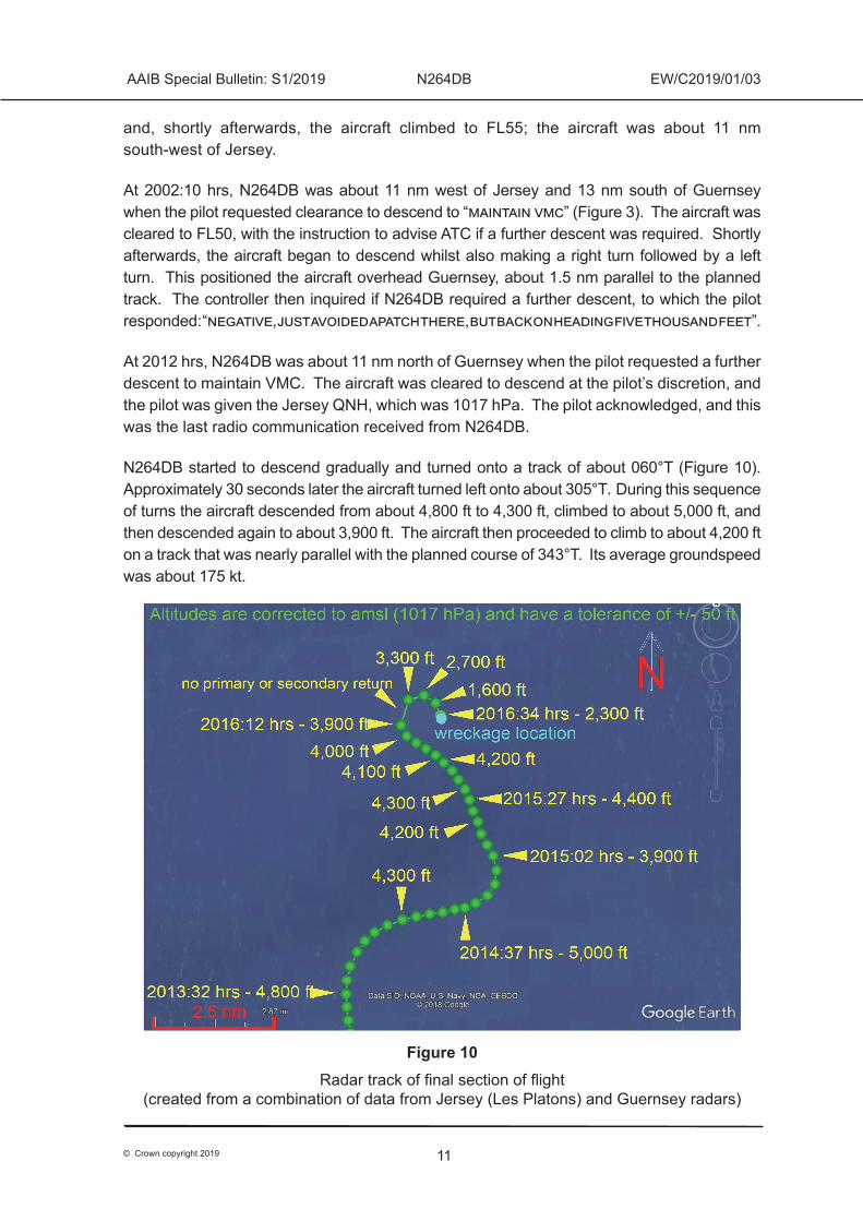
N264DB started to descend gradually and turned onto a track of about 060°T (Figure 10). Approximately 30 seconds later the aircraft turned left onto about 305°T. During this sequence of turns the aircraft descended from about 4,800 ft to 4,300 ft, climbed to about 5,000 ft, and then descended again to about 3,900 ft. The aircraft then proceeded to climb to about 4,200 ft on a track that was nearly parallel with the planned course of 343°T. Its average groundspeed was about 175 kt.
Figure 10Radar track of final section of flight
(created from a combination of data from Jersey (Les Platons) and Guernsey radars)
12
AAIB Special Bulletin: S1/2019 N264DB EW/C2019/01/03
© Crown copyright 2019
At about 2015:30 hrs, N264DB started to make a gradual left turn, which was followed at about 2016:10 hrs by a right turn of approximately 180°. During this turn, data from two independent radars (Guernsey and Jersey12) showed the aircraft descend to an altitude of about 1,600 ft at an average rate of approximately 7,000 ft/min. A few seconds later (at 2016:34 hrs) the final secondary radar return was recorded, which indicated that the aircraft may have climbed rapidly to about 2,300 ft. Two more primary radar returns were recorded, timed at 2016:38 hrs and 2016:50 hrs respectively, but it is not yet known whether they represent valid returns from the aircraft.
The regulatory framework for the accident flight
The investigation is considering the regulations applicable to the operation of this flight including airworthiness requirements; flight crew licencing; and the carriage of passengers. The requirements are set out below.
Airworthiness, aircraft permissions and maintenance
Aviation in the USA is regulated by the FAA. The Code of Federal Regulations (CFR) Title 14 Aeronautics and Space (known as 14 CFR) contains the Federal Aviation Regulations and is available through the FAA website13. Any aircraft registered in the USA, wherever it is based in the world, is regulated in accordance with the FAA 14 CFR.
N264DB was subject to the requirements of FAR Part 91, General Operating and Flight Rules. These regulations allowed the aircraft to be flown by private pilots holding an appropriate licence, but it was not allowed to be used for commercial operations without the owner or operator first obtaining permission from the FAA and the UK Civil Aviation Authority (CAA).
Ownership of N264DB had been transferred into a US Citizen Corporate Trust (known by the FAA as the Trustee and the CAA as the Owner Trust), which was a requirement to allow it to operate on the US register. The Trustee had a written contract with a UK Company, the Trustor, which had originally purchased the aircraft before transferring the title deed to the Trustee on 7 August 2015. The Trustee was responsible for registering the aircraft and passing all applicable airworthiness directives to the Trustor (which is known by the CAA as the Beneficial Owner).
The Trustor was responsible for the operation of the aircraft, ensuring it was maintained in accordance with applicable regulations and met all airworthiness requirements. The Trustor had an informal arrangement with a third party to manage the aircraft on its behalf.
Neither the Trustee nor the Trustor had applied to the FAA or the CAA to operate the aircraft for commercial reasons. The CAA advised the AAIB that they had no record of an application for permission to operate the aircraft commercially.
Footnote12 Data points were recorded once every four seconds by the radar located at Guernsey and once every five
seconds for the radar located at Jersey (Les Platons).13 https://www.faa.gov/regulations_policies/faa_regulations/ [accessed February 2019]
13
AAIB Special Bulletin: S1/2019 N264DB EW/C2019/01/03
© Crown copyright 2019
Oversight for the maintenance of aircraft operating in the UK which are registered in another State is carried out by, or on behalf of, the State of Registration, in this case the USA as represented by the FAA. The CAA may be asked to assist the FAA with safety checks or where a safety concern has been identified relating to a US registered aircraft operating in the UK.
Flight crew licencing
To fly an aircraft registered in the USA a pilot must hold a suitable licence, and licencing is governed by FAR Part 61, Certification: Pilots, Flight Instructors, and Ground Instructors. Part 61.3(a)(vii) states:
‘When operating an aircraft within a foreign country, a pilot license issued by that country may be used.’
Aviation in the European Union (EU) is regulated by the European Aviation Safety Agency (EASA), but pilot licences issued in accordance with EASA regulations are issued by Member State National Aviation Authorities (the CAA in the UK). A pilot may only hold one EASA licence, issued by a single Member State. The USA does not consider the European Union to be a State and so a flight between two EU Member States is a flight between two foreign countries within the meaning of Part 61.3(a)(vii). Such a flight would require the pilot to hold a licence issued in each Member State, which is not possible in the EU. Therefore, when an EASA licence issued in an EU Member State is used to fly an aircraft registered in the USA, the flight must remain within the borders of that Member State. The corollary is that, to fly an aircraft registered in the USA between two EU Member States, as was the case with the accident flight, a pilot must use an FAA licence.
Part 61 offers two routes to gain an FAA PPL and the first is laid out in Part 61.103. An FAA PPL would be gained this way by completing the FAA syllabus, examinations, flight training and flight test. Such a licence includes a night flying qualification because night flying is part of the FAA PPL syllabus.
The second way to gain an FAA PPL is through a certificate issued on the basis of a foreign pilot licence (‘piggybacking’). The rules for this are contained in Part 61.75 which state that such a certificate:
‘Is subject to the limitations and restrictions on the person’s U.S. certificate and foreign pilot license when exercising the privileges of that U.S. pilot certificate in an aircraft of U.S. registry operating within or outside the United States.’
It is possible for aircraft ratings and instrument ratings to be piggybacked onto an FAA licence from a foreign licence. For example, an FAA PPL issued on the basis of an EASA PPL could be used for night flying if the pilot had an EASA night rating (night flying is not included in the EASA PPL syllabus).
14
AAIB Special Bulletin: S1/2019 N264DB EW/C2019/01/03
© Crown copyright 2019
The pilot of N264DB held an EASA PPL, issued by the CAA in the UK, and an FAA PPL, issued on the basis of his EASA PPL. It is thought that the pilot’s licence and logbook were lost with the aircraft and so the ratings on his licences and their validity, and the extent of his recent flying have not yet been determined.
Carriage of passengers
A PPL does not allow a pilot to carry passengers for reward; to do so requires a commercial licence14. The basis on which the passenger was being carried on N264DB has not yet been established but, previously, the pilot had carried passengers on the basis of ‘cost sharing’. Cost sharing allows a private pilot to carry passengers and for those passengers to contribute towards the actual cost of the flight. Cost sharing brings benefits to private pilots who, by sharing the expense of their flying, can fly more than they might otherwise be able to, thereby increasing their level of experience. A higher level of regulatory burden applies to commercial, compared with private flights (such as more stringent medical, licencing and airworthiness requirements), and the additional requirements increase the level of safety assurance. Therefore, although the UK, EU and US regulatory authorities allow cost sharing, they apply restrictions to it.
European and UK national regulations permit pilots to share the direct costs of a flight without having to comply with regulations applicable to Commercial Air Transport or Public Transport flights. The proportion of the costs that must be shared by the pilot is not specified; however, the pilot must contribute to the actual direct costs of the flight being conducted. The CAA has produced guidance documents for the General Aviation community such as CAP1590, Cost sharing flights: guidance and information,15 and CAP 1589, Cost sharing flights: GA Guide16.
The EASA permits cost sharing on aircraft registered in a third country, such as the USA, but the relevant EASA rules state there may also be a requirement to comply with any regulations of the State of Registry. FAR Part 61.113 prohibits holders of a PPL from acting as Pilot in Command (PIC) of an aircraft carrying passengers for compensation or hire except in certain circumstances. When carrying passengers under the relevant dispensation a private pilot:
‘may not pay less than the pro rata share of the operating expenses.’
Footnote14 Commercial Pilots Licence (CPL) or Airline Transport Pilots Licence (ATPL).15 CAP 1590. Available: https://publicapps.caa.co.uk/docs/33/CAP1590%20Cost%20Sharing%20Flights%20
(Aug%202018).pdf [accessed February 2019]16 CAP 1589. Available: http://publicapps.caa.co.uk/docs/33/CAP1589%20-%20cost%20sharing%20GA%20
guide_v3%20(Aug%202018).pdf [accessed February 2019]
15
AAIB Special Bulletin: S1/2019 N264DB EW/C2019/01/03
© Crown copyright 2019
The FAA issued legal interpretations in 200917 and 201418 making clear that a pilot must not pay less than the pro rata share for the flight. If the flight involves the pilot and one passenger, then the pilot must pay half the operating expenses. The ruling also made clear that the pilot must have a bona fide purpose (also known as common purpose) for making the flight and must dictate when the flight is to go. The flight must not be made for the purpose of merely transporting the passenger.
Summary of regulatory issues
N264DB was registered in the USA and could not be used for commercial operations without permission from the FAA and CAA. At the time of writing there was no evidence that such permission had been sought or granted.
To fly an aircraft registered in the USA between EASA Member States, a pilot must operate using the privileges of an FAA licence. This licence may be:
a. Issued based on the privileges of an existing EASA PPL. If the EASA PPL contains a night rating, the FAA PPL will have night flying privileges.
b. Issued by the FAA following the completion of an approved PPL course. The privileges of a licence gained in this way will include night flying.
The pilot had an FAA PPL issued on the basis of his EASA PPL. His logbook and licence were not recovered from the aircraft, and the ratings on his licences and their validity dates have not yet been established.
If the flight was planned to be operated on a cost sharing basis, FAA rules regarding pro rata costs and a common purpose were applicable.
Further work
The investigation continues to examine all pertinent operational, technical, organisational and human factors which might have contributed to the accident. In particular, work will be undertaken to:
a. Refine the analysis of the radar information to try and understand the last few minutes of the flight.
b. Assess the possible implications of the weather conditions in the area at the time of the accident.
Footnote17 https://www.faa.gov/about/office_org/headquarters_offices/agc/practice_areas/regulations/
interpretations/data/interps/2009/mangiamele%20-%20(2009)%20legal%20interpretation.pdf [accessed February 2019]
18 https://www.faa.gov/about/office_org/headquarters_offices/agc/practice_areas/regulations/interpretations/data/interps/2014/macpherson-jonesday%20-%20(2014)%20legal%20interpretation.pdf [accessed February 2019]
16
AAIB Special Bulletin: S1/2019 N264DB EW/C2019/01/03
© Crown copyright 2019
Published 25 February 2019
AAIB investigations are conducted in accordance with Annex 13 to the ICAO Convention on International Civil Aviation, EU Regulation No 996/2010 and The Civil Aviation (Investigation of Air Accidents and Incidents) Regulations 2018.The sole objective of the investigation of an accident or incident under these Regulations is the prevention of future accidents and incidents. It is not the purpose of such an investigation to apportion blame or liability. Accordingly, it is inappropriate that AAIB reports should be used to assign fault or blame or determine liability, since neither the investigation nor the reporting process has been undertaken for that purpose.Extracts may be published without specific permission providing that the source is duly acknowledged, the material is reproduced accurately and is not used in a derogatory manner or in a misleading context.
c. Analyse video from the ROV to determine the aircraft attitude as it entered the water.
d. Consider the regulatory requirements surrounding the flight including airworthiness requirements, aircraft permissions and flight crew licencing.
A final report will be published in due course.