Embed Size (px)
Citation preview

Lake
Mic
higa
n IndianaRecreationalAccess Guide
IndianaRecreationalAccess Guide
Lake
Mic
higa
n
2
This publication was developed by the IDNR Division of OutdoorRecreation. Comments should be directed to: 402 West Washington Street,Room W271. Indianapolis, IN 46204. 219/232-4070.
This guide was funded in part by a grant from the National Oceanic andAtmospheric Administration.
Support for this publication was provided in part through the Federal Aidto Sport Fish Restoration Program. Grant moneys were made available bythe US Fish & Wildlife Service.
Contents
Acknowledgements
A History of Cooperation Along the Lake Shore ...................................... 3
Focus Group Summary ................................................................................. 4
Lake Michigan Physical Description .......................................................... 6
Recreation On and Along Lake Michigan .................................................. 8
Lake Shore Maps ......................................................................................... 11
For More Information and Literature Cited ........................................... 22
Appendices
Appendix A ................................................................................................. 23Focus Group Summary
Appendix B .................................................................................................. 35Lake Michigan Access Survey
Appendix C ................................................................................................. 39Indiana Recreation Facilities Inventory Update
Indiana Recreational Access Guide for Lake Michigan
3
A History of CooperationAlong the Lake Shore
In the early 1970s, the federalgovernment recognized the needfor establishing a national coastalresource management frame-work. In 1972, Congress passedthe Coastal Zone Management(CZM) Act. The basic goal was toencourage coastal states to volun-tarily develop comprehensivemanagement plans. The Act wasreauthorized in 1976, 1980, 1986,1990, and 1996. It is administeredat the federal level by the U. S.Department of Commercethrough the National Oceanic andAtmospheric Administration(NOAA), and at the state level byvarious state agencies includingDepartments of Natural Re-sources.
Although Indiana conductedseveral CZM studies in the 1970s,it remains (along with Illinois andMinnesota) a non–participatingstate.
In 1991, the Natural ResourcesCommission responded to thecontinuing need for an intelligentmanagement plan by urging theDepartment of Natural Resources(DNR) to establish a master planfor the Lake Michigan shoreline.A contract with the NorthwestIndiana Regional PlanningCommission was authorized toexplore the development of acomprehensive managementplan. As part of this process, aseries of public meetings wereheld along the shoreline to obtaincitizen input on the Coastal Zone
Management plan development.Although boating issues wereparamount, it quickly becameclear there were many moreissues at stake.
In 1993 the IDNR received fund-ing through NOAA to exploreparticipation by Indiana in thefederal coastal program. As partof this effort, the DNR conducteda public work group process in1995 to identify issues and pos-sible solutions to those issuesalong the state’s Lake Michiganshoreline. Several recommenda-tions were made by the groupsregarding recreational needs.Recognizing the human andenvironmental diversity of North-west Indiana, the Natural Re-sources Commission adopted aresolution in May 1995 in supportof efforts to improve communica-tion and coordination in the useand enjoyment of Indiana’s LakeMichigan Coastal Region. Theresolution also made severaldirectives to the Departmentincluding “expand and enhancemeaningful opportunities forpublic participation by citizens ofNorthwest Indiana in decisionmaking relative to natural, cul-tural, commercial, and recre-ational resources.”
The Lake Michigan MarinaDevelopment Commission passeda number of resolutions onboating safety and enforcement inSeptember of 1995. These resolu-tions encouraged the DNR to,
among other things, “developand distribute a boating guide tothe Lake Michigan shoreline forboat operators and the generalpublic…”. One purpose for thisguide was to inform the publicwhat access opportunities existalong Lake Michigan. Because animportant focus of the federalCZM program is planning forrecreational access to the shore-line, the DNR was able to usefederal dollars to respond tocertain public work group recom-mendations and Marina Commis-sion resolutions. Additionally, theDNR could further statewiderecreation goals by identifyingexisting and needed access sitesand types, and by gatheringcitizen input on shoreline issues.A major effort of the DNR Divi-sion of Outdoor Recreation is thecreation of the Statewide Com-prehensive Outdoor RecreationPlan (SCORP). The SCORP is afive year master plan outliningthe state’s recreation supply anddemand. Part of this document isan inventory of existing outdoorrecreation sites and facilities.Each site is visited by DNR staffand located using global posi-tioning system technology forentering into the DNR GISdatabase. Also, comprehensiveinformation about the site, suchas the managing agency, type ofsite, kinds and number of facili-ties and sports allowed, wateraccess, and overnight accommo-dations, is collected and enteredinto the same GIS database.
A History of Cooperation Along the Lake Shore
4
Focus Group Summary
As part of the Coastal Coordi-nation Program process, the DNRDivision of Water held severalpublic work group meetingsconcerning the Lake Michiganshore line and watershed. Onetopic that came out of these workgroups was recreational accessand opportunities. The DNRDivision of Outdoor Recreationwanted to find out the signifi-cance of this issue, so five focusgroup meetings were held duringApril, May, and June, 1996 inNorthwest Indiana. These meet-ings were separated into relatedinterests. The different groupsinvolved were: Private recreationproviders, Public recreationproviders, User groups, Electedofficials and Commissioners, andBusiness and Industry. A total of39 people attended the meetings.The User groups category had thegreatest attendance.
Indiana Recreational Access Guide for Lake Michigan
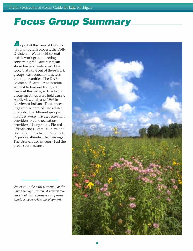
Water isn't the only attraction of theLake Michigan region. A tremendousvariety of native grasses and prairieplants have survived development.
5
Each meeting was conducted inthe same manner. In order tokeep the data consistent, facilita-tors were used to lead each groupthrough the same process. A“Cause and Effect” process wasdesigned to elicit opinions andsolutions on access to the lake.The first thing each group didwas decide if there is or is notenough access to the lakeshore.They then brainstormed thereasons why access was an issue.They then categorized each issueinto a “Provider”, “Consumer”,or “Resource” topic. Finally, theycame up with some solutions tothe problem of lack of lakeshoreaccess. A more complete explana-tion is included in the appendix.
In general, the majority of theattendees felt there is a lack ofadequate access to the lake shore.For whatever use—swimming,boating, sunbathing, walking—there simply isn’t enough. Alongwith the basic deficiency, peoplefelt the access that did exist wasinconsistent in pricing, hoursopen, security, facilities offered,access for persons with disabili-ties, and policies and enforce-ment.
A common theme throughout thefocus groups was inadequateinformation about access to thelakeshore and associated facili-ties. A common sentiment voicedwas unless you were a Region“native”, you really didn’t knowall the places to go. Also, whenparking lots or beaches are atcapacity, the attendants don’tknow of other spots to referpeople to. A frequently men-tioned idea was a three–countybrochure that would detail all ofthe access sites, who owns them,and on–site facilities available.Also, access to Lake Michigan
tributaries (Trail Creek, SaltCreek, and Burns Waterway) isextremely limited for anglers andboaters.
Another recurrent thought cen-tered on governmental inflexibil-ity. Many people are of the opin-ion that state and federal govern-ment property holders are notresponsive to the needs anddesires of the local population. Itwas thought that Dunes StatePark and the National Lakeshoreneed to be opened to more access,especially boat–in mooring. Thegeneral public is kind of annoyedthat there is only one way to getinto the State Park, and thatneither the state nor the federalgovernment owners allow boatsto moor along the beach (or evencome closer than 200 feet fromshoreline. This creates a three–mile stretch of beach that isbasically inaccessible. Also,private property owners limit theamount of access that is available.
A third common theme was theneed for increased and better
Focus Group Summary
cooperation and coordination ofplanning efforts between thediffering entities along the shoreline. Many felt that public/private partnerships need to beencouraged more. This is espe-cially true in light of the fact thatthere is no more land that is ableto be acquired for public access—its already all owned. If the steelindustries that hold the majorityof the land base could be encour-aged to open more of their prop-erties to the locals, access couldbe dramatically increased. Fund-ing was a big part of this too.Especially within the users focusgroup—they felt tax dollarscollected from the area should bespent only in Northwest Indiana.
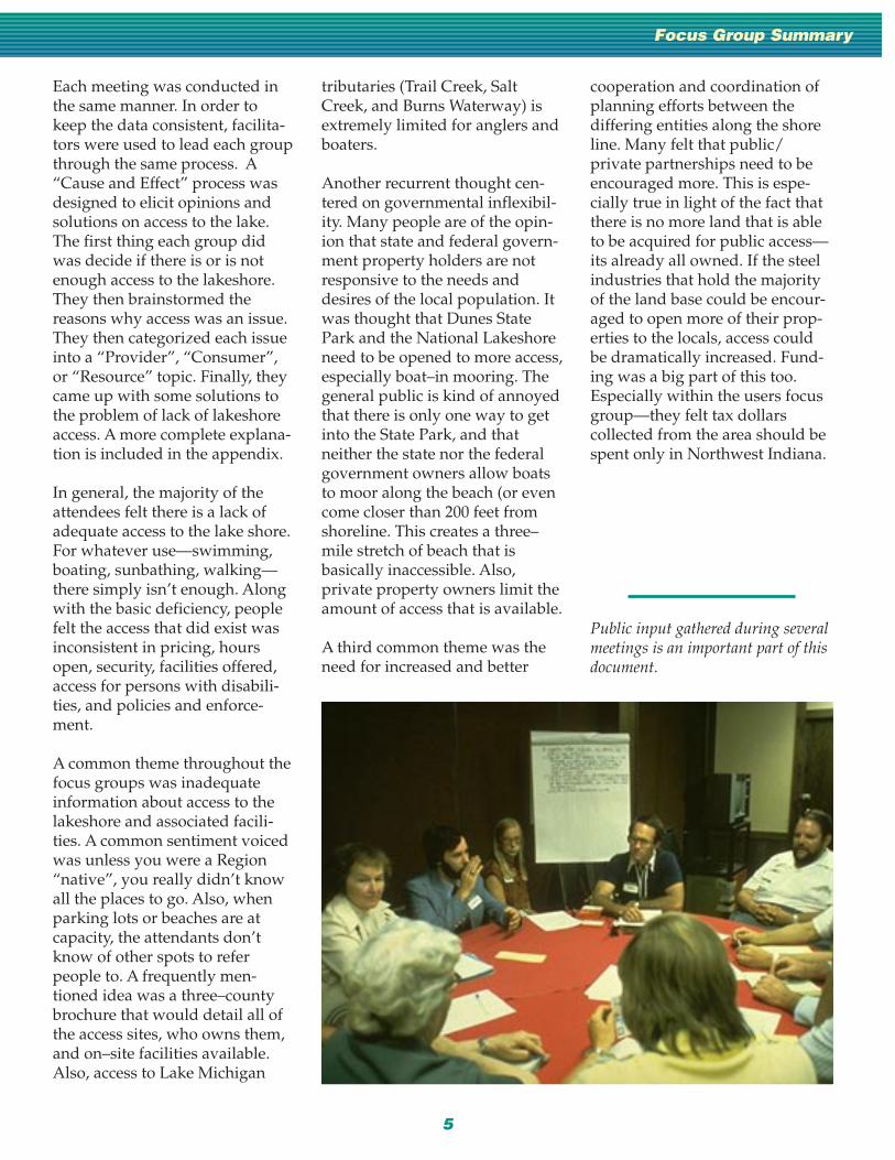
Public input gathered during severalmeetings is an important part of thisdocument.

6
Indiana Recreational Access Guide for Lake Michigan
Lake MichiganPhysical Description
Lake Michigan is the secondlargest of the Great Lakes and isthe only one wholly inside theUnited States. The southern basinis among the most urbanizedareas in the Great Lakes system.Within Indiana, the shoreline is 45miles long and includes a smallpart of Lake, Porter, and LaPortecounties, forming the northwestborder of the state. Pre–settlementvegetation includes prairie,deciduous hardwood, and wet-land species. The Dune and Swalecomplexes found in this regionare globally significant, and Lake,Porter, and LaPorte countiescontain the greatest number ofrare plant species left in Indiana.In fact, a recent inventory con-ducted by The Nature Conser-vancy states that Indiana DunesNational Lakeshore ranks thirdamong all national parks in plantdiversity.
The northwest region is home toover 700,000 persons (1990 data),and is the most ethnically diversearea in the state, with 18 percentof its population being AfricanAmerican and 7 percent beingHispanic. Northwest Indiana’scitizens live among a mix ofdensely populated cities, steelmills, petro–chemical and powerplants, as well as unique naturalareas, wetlands, and forestedareas. Along the shoreline, resi-dential uses comprise 39 percentof total land area, recreationaluses make up 24 percent, agricul-ture is 20 percent, commercial is
12 percent, and there is 5 percentin “other ” uses.
The arrival of European settlershas produced the most rapidchange in the species supportedwithin the Great Lakes ecosys-tem. It is estimated that thereonce were as many as 180 speciesof fish native to the Great Lakes.Because of the differences in thecharacteristics of the lakes, thespecies composition varied foreach of the Great Lakes. Changesin the species composition in thelast 200 years have been the resultof human activities. Many nativefish species have been lost byover–fishing, habitat destructionor the arrival of exotic or non–native species, such as the lam-prey and the alewife. Pollution,especially in the form of nutrientloading and toxic contaminants,has placed additional stresses onfish population. Other man–madestresses have altered reproductiveconditions and habitats, causingsome varieties to migrate orperish. Today, lake trout, stur-geon, and lake herring survive invastly reduced numbers and havebeen replaced by introducedspecies such as smelt, alewife,splake, and Pacific salmon.
Commercial and sport fishing arenot the only economic uses of thelake. The three main commoditiesshipped on the Great Lakes areiron ore, coal and grain. In Indi-ana, iron ore, Limestone andmetal products are the largest
commodities shipped through theports at Indiana Harbor,Buffington Harbor and BurnsInternational Waterway.
Due in part to the enormousamounts of commecial andtourist use of its waters, fish andbirds in and along Lake Michigancontain some of the greatestcontaminant levels in all of theGreat Lakes. In 1983, the Interna-tional Joint Commission reportedthat 900 chemicals and heavymetals that are potentially dan-gerous to human health and biotahad been identified in the GreatLakes. The Commission hasidentified 43 Areas of Concernalong the Great Lakes shoreline inCanada and the United States.One such area of concern is theGrand Calumet River/IndianaHarbor Ship Canal. This area is socontaminated by toxic sedimentsthat there are impairments in allfourteen beneficial uses. Theimpairments are: restrictions offish and wildlife consumption;tainting of fish and wildlifeflavor; degradation of fish andwildlife populations; fish tumorsor other deformities; birds oranimal deformities or reproduc-tive problems; degradation ofbenthos; restrictions on dredgingactivities; eutrophication orundesirable algae; restrictions ondrinking water consumption, ortaste and odor problems; beachclosings; degradation of aesthet-ics; added costs to agriculture orindustry; degradation to phy-
7
toplankton and zooplanktonpopulations; and loss of fish andwildlife habitat. The UnitedStates Geographical Service, incooperation with U.S. Environ-mental Protection Agency, Indi-ana Department of Environmen-tal Management and the Michi-gan and Wisconsin Departmentsof Natural Resources is estimat-ing the total mass balance ofpollutants entering the ecosystemof Lake Michigan. Scientists arecurrently (1995) monitoring 11tributaries that make up 50percent of the drainage area ofLake Michigan and are assumedto contribute more than 90 per-cent of the tributary load of PCBs.Data gathered will be used todevelop a mass–balance modelfor Lake Michigan that will beused to evaluate managementoptions to reduce chemical
concentrations. Retention time isa measure scientist use to under-stand the volume of water in alake and the mean rate of out-flow. Because Lake Michigan’sretention time is 99 years, thepollutants that enter the systemstay a very long time and becomemore concentrated.
Lake Michigan water levelsusually cycle annually with highsin the midsummer (July) and lowlevels occurring in midwinter(February). This fluctuation inwater levels creates problems forlakeshore dwellers. Between theten–year cycle between February1964 and July 1974, there was asix–foot rise in water level.Coastal Erosion and Submer-gence USGS studies along south-ern Lake Michigan determinedthat lake levels previously have
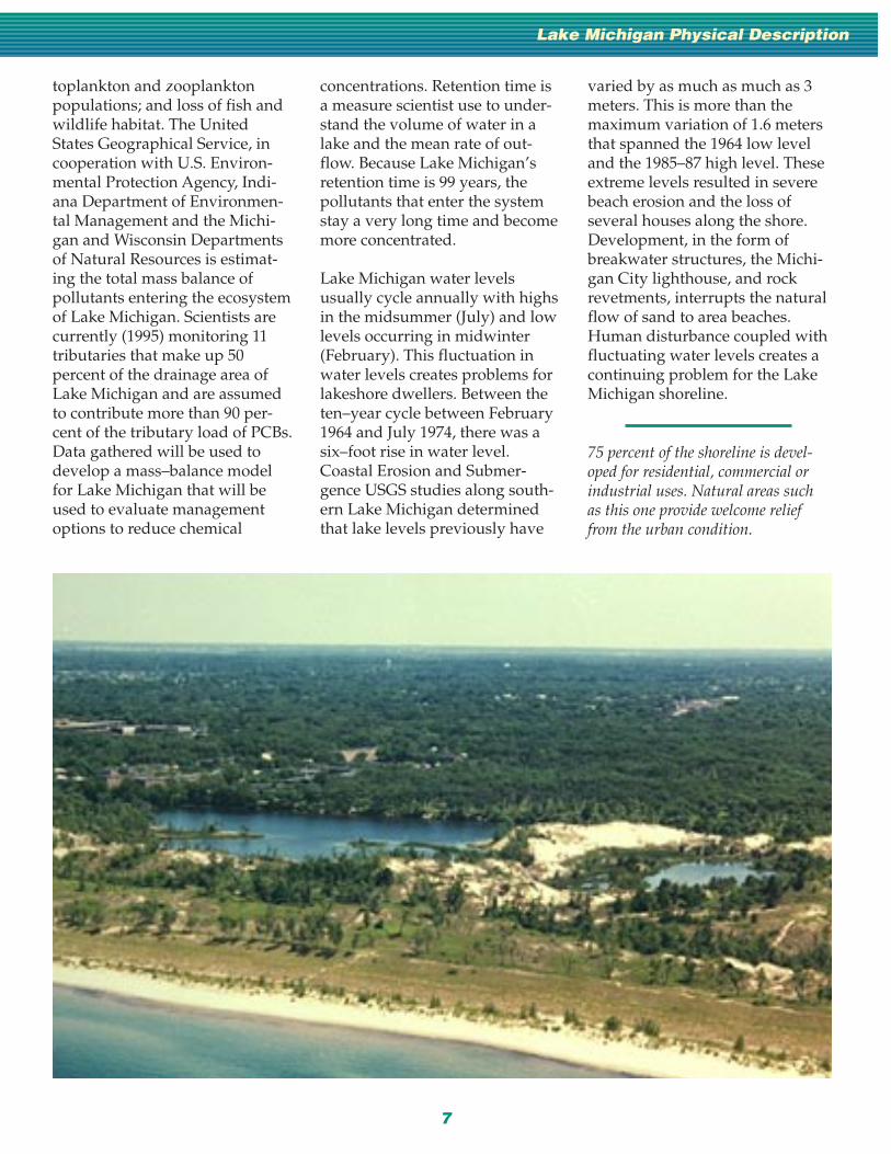
75 percent of the shoreline is devel-oped for residential, commercial orindustrial uses. Natural areas suchas this one provide welcome relieffrom the urban condition.
varied by as much as much as 3meters. This is more than themaximum variation of 1.6 metersthat spanned the 1964 low leveland the 1985–87 high level. Theseextreme levels resulted in severebeach erosion and the loss ofseveral houses along the shore.Development, in the form ofbreakwater structures, the Michi-gan City lighthouse, and rockrevetments, interrupts the naturalflow of sand to area beaches.Human disturbance coupled withfluctuating water levels creates acontinuing problem for the LakeMichigan shoreline.
Lake Michigan Physical Description

8
Indiana Recreational Access Guide for Lake Michigan
Recreation On andAlong Lake Michigan
The lake shore has alwaysbeen a magnet for people whowanted to see the sites, play inthe water and along the beach,and protect the unique lake shoreresources. In order to gather aclear idea of how people areusing the lake shore, a surveywas conducted during the monthof July at various times—weekdays, evenings, and weekends(including the July 4 holiday).The survey was administered atsix different sites: Indiana Dunes
National Lakeshore West Beach,Portage Public Marina, Washing-ton Park Beach, Washington ParkMarina, Whihala Beach CountyPark, and Hammond Marina. Thesurvey was conducted using asimple paper check sheet. Thesurvey administrator was avail-able to answer questions aboutthe survey tool, but did notactually ask the question. Eachquestion was followed by severalchoices, allowing people to checkthe appropriate answer. Space
was also provided for comments.
Lake shore users: Men andwomen were fairly equallydivided with male respondentscomprising 56%, female, 44%. So,
Fishing and boating are among themost popular Lake Michigan activi-ties.

9
Recreation On and Along Lake Michigan
men and women both utilize thelake shore. Ages from 25 years to54 years were the majority ofusers. Married couples were byfar the greatest category of users,comprising 56% of the respon-dents. Most users live in Indiana,with Illinois a close second (54%vs. 42%). Of Indiana residents,54% live in Lake County; Illinoisresidents mostly live in CookCounty (74%). An overwhelmingnumber (90%) of survey respon-dents were white, with Hispanic(6%) being the second mostnumber of users. Income fell intoseveral categories, the largest ofwhich is $60,000 to $74,999annually. Only 7% of all therespondents made less than$19,999 annually. When peoplecame to the lake shore, they mostfrequently did so in groups oftwo (30%). Groups of four (21%)were next. Only 2% participate inactivities along the lake shore ingroups of nine or more.
The majority of the surveyquestions were meant to learnwhat people actually did whenthey went to the lake shore toplay. Respondents were alsoasked if they had trouble access-ing the lake shore, and whatadditional (if any) facilities mightbe needed. Finally, they wereasked what was most importantto them.
The top three activities are:swimming (46%), power boating(40%), and picnicking (18%).Nature observation, hiking/walking, and boat fishing wereother activities that more than10% of respondents indicateddoing.
When asked if additional facilitieswere needed at Lake Michigan,68% responded “no, the current
facilities are okay”. We thenlooked at each survey site andcross–referenced it to a particularactivity. In doing this, we foundthat most people felt access forswimming is adequate at allfacilities except HammondMarina. Access for fishing isadequate except at Indiana Dunes(West Beach), and access forboating is adequate at all sites.
Citizens were asked to select thethree items (from a total of elevenchoices) that were most importantto them. Fifty–eight percent saidwater quality is the most signifi-cant. The second most importantwas a tie between the naturalbeauty of the site and site cleanli-ness with 49% choosing theseitems. Good swimming wasfourth at 35%, followed by sitesecurity with 30%. It is interestingto note that good picnicking wasone of the least important itemsto the general public (at only 8%),even though picnicking is one ofthe most popular activities. Othernoteworthy items were, theexistence of hiking/nature trails,and the safety of fish consump-tion, both at 8%.
When asked if additional facilitieswere needed, 68% responded inthe negative. Of those who feltmore facilities were desirable,29% felt more beaches wereneeded, 25% felt more publicopen space was desirable, and22% responded positively to bothmore boat–in beaches and morerental equipment.
The Division of Outdoor Recre-ation is responsible for conduct-ing an inventory of outdoorrecreation sites and facilitiesthroughout the state. During thesummer of 1996, the divisionconducted an inventory of sites
within the coastal zone manage-ment area of Lake, Porter, andLaPorte counties. The inventoryincludes making a site visit toeach facility, taking a latitude/longitude point, and compilinginformation on the site and on themanaging agency. There is a widevariety of recreation opportuni-ties available in northwest Indi-ana, although not all of therecreation sites provide directlake access.
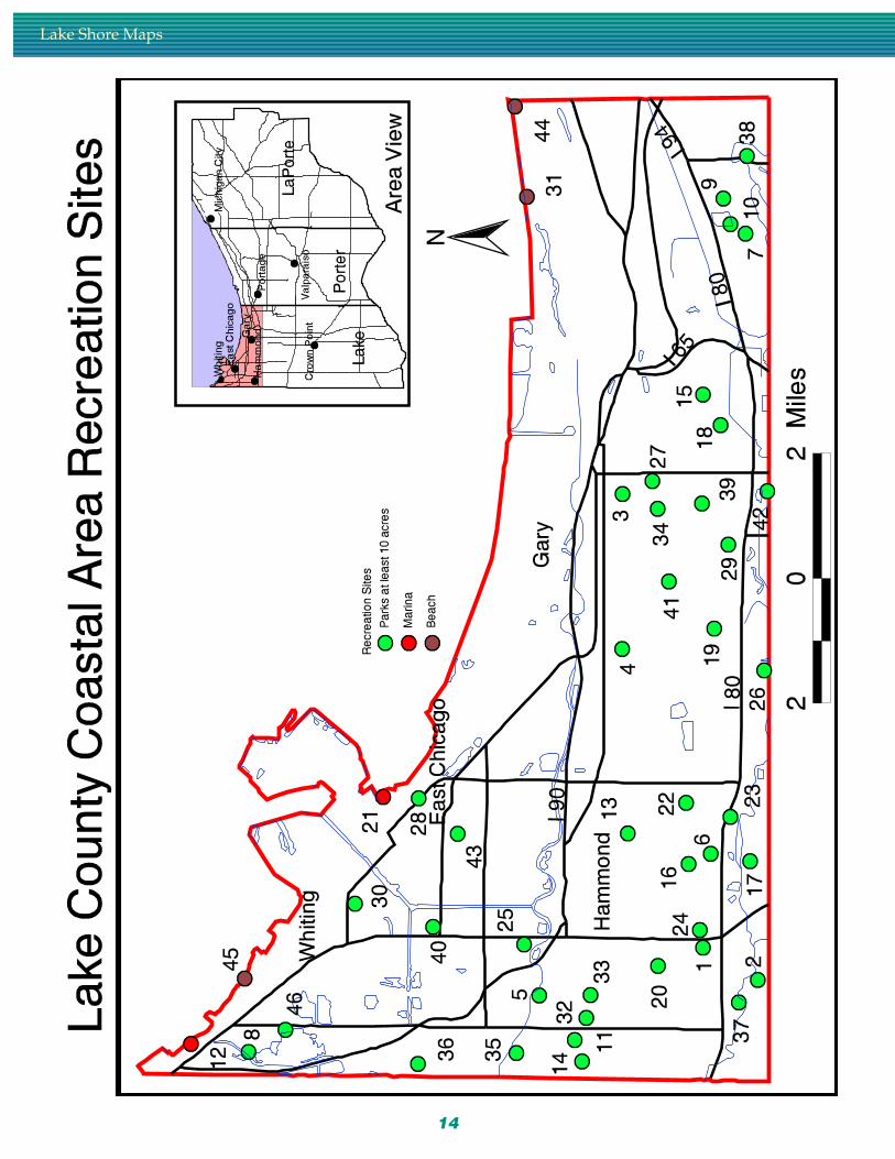
In Lake county, there are 51 sitesthat are within the coastal zone.The smallest site is .25 acres insize and the largest is 607 acres.These facilities are both publiclyand privately owned, and include31 park and recreation areas, 2fishing/boating access sites, 1camping/trailer park, 1 trail, 3marinas, 2 beaches, 1 fairground,4 non–profit recreation facilities, 1outdoor education facility, 4 golfcourses, and 1 private, non–profitrecreation facility.
In Porter county, there are 80sites. The smallest site, Kipperpark, is .3 acres and the largestsite, Indiana Dunes State Park, is2, 182 acres. These facilities areboth public and privately ownedand include 44 park and recre-ation areas, 4 camping/trailerparks, 2 trails, 3 marinas, 2 com-mercial/private fishing lakes, 1beach, 1 outdoor pool, 1 fair-ground, 4 for–profit recreationfacilities, 6 non–profit recreationfacilities, 6 sports complexes, and5 golf courses.
LaPorte county has 67 sites. Thesmallest site, Scott Field park, is1/2 acre and the largest site,Soldiers Memorial park, is 556acres. These facilities are bothpublic and privately owned andinclude 34 park and recreation

Recreation On and Along Lake Michigan
areas, 2 forest areas, 2 dedicatednature preserves, 2 fishing/boating access sites, 3 marinas, 1fairground, 4 commercial forprofit recreation facilities, 3 sportscomplexes, 3 beach access sites,and 3 golf courses.
The Department of NaturalResources is an active partner inproviding recreation opportuni-ties within Northwest Indiana.The DNR owns six sites withinthe coastal area. Additionally, theDNR administers several grantprograms; two of which have hadsignificant impacts in formingpartnerships with local park andrecreation boards to provideoutdoor recreation facilities to thepublic. These programs are theLand and Water ConservationFund and the Indiana Waters, AFishing and Boating Access
Program. Together, these grantshave funded a total of sixty–onegrant projects within the coastalzone management area. Oneadditional project was fundedthrough the Hometown Indianagrant program. Of the sixty– twoprojects, Lake county has forty–five projects, Porter county hasfifteen projects, LaPorte countyhas five projects, and the Depart-ment of Natural Resources haseight projects.
Swimming and sunbathing areactivities enjoyed by more than halfof all lake shore users.
10
Map
sM
aps Lake
ShoreMaps
LakeShoreMaps

12
Lake Shore Maps

13
Recreation Sites in the Coastal Region
14
Lake Shore Maps
15
KE
Y
Ath
leti
c Fi
eld
s: S
B=
Sof
tbal
lB
B=
Bas
ebal
l S=
Soc
cer
Cou
rts:
B=
Bas
ketb
all
T=
Ten
nis
V=
Vol
leyb
all
(san
d)
Res
troo
ms:
F=
Flu
sh P
= P
orta
ble
X=
Pit
Trai
ls: F
= F
itne
ss M
= M
ulti
-pu
rpos
e W
= W
alki
ng o
nly
S=Sk
i (cr
oss-
coun
try)
Lake County Coastal Area Recreation Sites
1B
arin
g P
arkw
ay21
9/85
3-63
7829
•B
,2
Bee
ch P
ark
219/
836-
8810
14•
SB
T•
P3
Bor
man
Par
k21
9/88
6-65
7712
•V
•F
•S
B,
B,
4B
runs
wic
k P
ark
219/
886-
6577
49•
BB
T•
FW
•5
Col
umbi
a P
ark
219/
853-
6378
12•
SB
B•
FB
,6
Dow
ling
Par
k21
9/85
3-63
7851
•S
BT
F7
Fai
rvie
w P
arkw
ay21
9/96
2-75
0810
•S
B,
8F
orsy
the
Par
k21
9/85
3-63
7865
•B
BT
FM
••
•B
,S
B,
T,9
Fou
r W
inds
Par
k21
9/96
2-75
0826
•S
V•
Gra
nd B
oule
vard
Lak
e10
Rec
reat
ion
Are
a21
9/96
2-75
0840
••
•11
Ham
mon
d C
ivic
Cen
ter
219/
853-
6378
14S
BT
F•
12H
amm
ond
Mar
ina
219/
659-
7678
F•
••
••
SB
,13
Har
ding
Par
k21
9/85
3-63
7815
•S
V B,
14H
arris
on P
ark
219/
853-
6378
25•
SB
T•
XS
B,
15H
atch
er P
ark
219/
886-
6577
15•
FB
•F
•B
,16
Hes
svill
e P
ark
219/
853-
6378
14•
BB
T•
FB
,T,
17H
omes
tead
Par
k21
9/83
8-01
1454
•S
BV
•F
Acreage
No Facilities
Playground
Athletic Fields
Courts
Picnic Shelters
Restroom Facilities
Trails
Fishing Access
Boating Access
Boating Facilities
Beach
Swimming
Camping Facilities
Community Center

16
KE
Y
Ath
leti
c Fi
eld
s: S
B=
Sof
tbal
lB
B=
Bas
ebal
l S=
Soc
cer
Cou
rts:
B=
Bas
ketb
all
T=
Ten
nis
V=
Vol
leyb
all
(san
d)
Res
troo
ms:
F=
Flu
sh P
= P
orta
ble
X=
Pit
Trai
ls: F
= F
itne
ss M
= M
ulti
-pu
rpos
e W
= W
alki
ng o
nly
S= S
ki (c
ross
-cou
ntry
)
Lake Shore Maps
B,
18Ir
onw
ood
Par
k21
9/88
6-65
7711
•S
BT
•S
B,
BB
,B
,19
Irvi
ng P
ark
219/
853-
6378
10•
ST
FW
20Je
ffers
on P
ark
219/
853-
6378
11S
B
21Je
orse
Par
k/P
astr
ick
Mar
ina
219/
391-
8482
37•
•F
W•
••
•22
Hig
gins
Par
k23
Ken
nedy
Par
k21
9/85
3-63
7889
•24
Kni
cker
bock
er P
arkw
ay21
9/85
3-63
7811
•S
B,
B,
25K
osci
uszk
o P
ark
219/
391-
8487
•B
BT
F F,M
,26
Lake
Etta
Cou
nty
Par
k21
9/73
8-20
2014
8•
•P
F•
••
•27
Line
ar P
ark
(Gar
y)21
9/88
6-65
7710
••
28Li
near
Par
k (E
ast C
hica
go)
219/
391-
8474
•29
MC
Ben
net P
ark
219/
886-
6577
47•
SB
T•
B,
30M
arkt
own
Par
k21
9/39
1-84
7413
•S
BT
•F
31M
arqu
ette
Par
k21
9/88
6-65
7724
0•
T•
F•
••
•
32M
artin
Lut
her
Kin
g Jr
. Par
k21
9/85
3-63
7817
•S
BB
•F
33M
emor
ial P
ark
219/
853-
6378
14•
SB
B•
34N
orto
n P
ark
219/
886-
6577
10•
SB
,35
Peo
ples
Par
k21
9/85
3-63
7813
•S
B,
36P
ulas
ki P
ark
219/
853-
6378
23•
SB
T•
SB
,B
B,
FB
,37
Riv
ersi
de P
ark
219/
853-
6378
56•
S•
F•
•

17
KE
Y
Ath
leti
c Fi
eld
s: S
B=
Sof
t-ba
ll B
B=
Bas
ebal
l S=
Socc
er
Cou
rts:
B=
Bas
ketb
all
T=
Ten
nis
V=
Vol
leyb
all
(san
d)
Res
troo
ms:
F=
Flu
sh P
= P
orta
ble
X=
Pit
Trai
ls: F
= F
itne
ss M
=M
ulti
-pur
pose
W=
Wal
k-in
g on
ly S
= S
ki (c
ross
-co
untr
y)
Lake County Coastal Area Recreation Sites
B,
T,F
38R
iver
view
Par
k21
9/96
2-75
0843
•S
BV
•P
F•
•39
Roo
seve
lt P
ark
219/
886-
6577
18•
SB
TF
•40
Tod
Par
k21
9/39
1-84
7424
•S
BB
F•
B,
41To
llest
on P
ark
219/
886-
6577
13•
SB
TF
•
FB
,S
B,
T,42
W.P
. Gle
ason
Par
k21
9/88
6-65
7720
8•
SV
•F
W•
••
B,
43W
ashi
ngto
n P
ark
219/
391-
8474
17•
SB
T44
Wel
ls S
tree
t Bea
ch21
9/85
3-63
7810
F•
••
45W
hiha
la B
each
Cou
nty
Par
k21
9/65
9-40
1521
F•
••
••
46W
olf L
ake
Par
k21
9/85
3-63
7841
0•
V•
M•
••
••
•
18
Lake Shore Maps
19
KE
Y
Ath
leti
c Fi
eld
s: S
B=
Sof
tbal
l BB
= B
aseb
all S
= S
occe
r
Cou
rts:
B=
Bas
ketb
all
T=
Ten
nis
V=
Vol
leyb
all (
sand
)
Res
troo
ms:
F=
Flu
sh P
= P
orta
ble
X=
Pit
Trai
ls: F
= F
itne
ss M
= M
ulti
-pur
pose
W=
Wal
king
onl
y S=
Ski
(cro
ss-c
ount
ry)
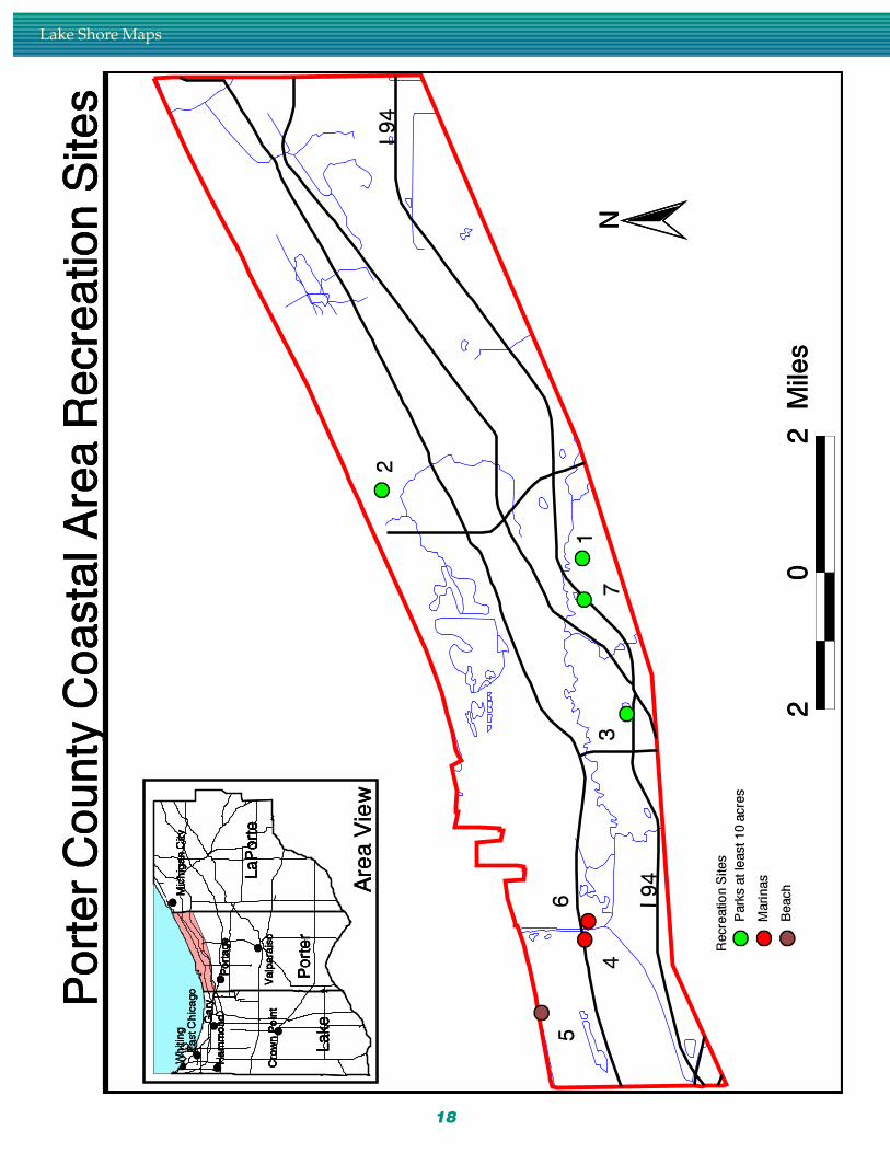
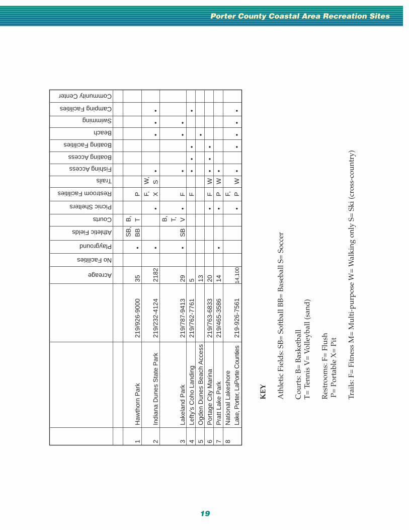
Porter County Coastal Area Recreation Sites
SB
,B
,1
Haw
thor
n P
ark
219/
926-
9000
35•
BB
TP F,
W,
2In
dian
a D
unes
Sta
te P
ark
219/
232-
4124
2182
••
XS
••
••
B,
T,3
Lake
land
Par
k21
9/78
7-94
1329
•S
BV
•F
••
•4
Lefty
’s C
oho
Land
ing
219/
762-
7761
5F
••
••
5O
gden
Dun
es B
each
Acc
ess
13•
6P
orta
ge C
ity M
arin
a21
9/76
3-68
3320
•F
W•
••
7P
ratt
Lake
Par
k21
9/46
5-35
8614
••
PW
•8
Nat
iona
l Lak
esho
reF,
Lake
, Por
ter,
LaP
orte
Cou
ntie
s21
9-92
6-75
6114
,100
•P
W•
••
••
Acreage
No Facilities
Playground
Athletic Fields
Courts
Picnic Shelters
Restroom Facilities
Trails
Fishing Access
Boating Access
Boating Facilities
Beach
Swimming
Camping Facilities
Community Center

20
Lake Shore Maps

21
KE
Y
Ath
leti
c Fi
eld
s: S
B=
Sof
tbal
l BB
= B
aseb
all S
= S
occe
r
Cou
rts:
B=
Bas
ketb
all
T=
Ten
nis
V=
Vol
leyb
all (
sand
)
Res
troo
ms:
F=
Flu
sh P
= P
orta
ble
X=
Pit
Trai
ls: F
= F
itne
ss M
= M
ulti
-pur
pose
W=
Wal
king
onl
y S=
Ski
(cro
ss-c
ount
ry)
LaPorte County Coastal Area Recreation Sites
1A
dam
s P
ark
219/
873-
1506
12•
SB
•P
2B
& E
Mar
ina
219/
879-
8301
1F
••
•3
Cre
ek R
idge
Cou
nty
Par
k21
9/87
3-70
1477
•V
•X
W•
SB
,B
,4
Gar
dena
Str
eet P
layg
roun
d21
9/87
3-15
0612
•B
BT
•W
5H
anse
n P
ark
219/
873-
1506
17•
SB
B•
6In
tern
atio
nal F
riend
ship
Par
k25
••
7N
ewpo
rt M
arin
aF
••
••
8P
hil S
prag
ue P
ublic
Mar
ina
219/
873-
1506
•X
••
•9
Pul
lman
Par
k21
9/87
3-15
0610
•S
BB
Tra
il C
reek
For
ks P
ublic
10A
cces
s21
9/23
2-40
80•
•11
Tra
il C
reek
Pub
lic A
cces
s21
9/23
2-40
8037
••
F,M
,12
Was
hing
ton
Par
k M
arin
a21
9/87
2-17
1299
•T
•X
W•
••
••
•
Acreage
No Facilities
Playground
Athletic Fields
Courts
Picnic Shelters
Restroom Facilities
Trails
Fishing Access
Boating Access
Boating Facilities
Beach
Swimming
Camping Facilities
Community Center

• Efficient Protection of Fisheries Habitat in Great Lakes Tributaries fromAgricultural Pollutants. Larson, et. al. 1990
• The Great Lakes. An Environmental Atlas and Resource Book. USEPAand Environment Canada. 1987
• The Nation’s Water Resources 1975-2000. U.S. Water Resources Council.1978.
• Indiana–Illinois Sea Grant Program.
• Guide to Great Lakes Areas of Concern/Remedial Action Plans. Con-sortium for International Earth Science Information Network (CIESIN).1994. On-line address: http://epawww.ciesin.org/gleris/nonpo/nprog/aoc_rap/aoc-home.html
• Indiana’s Shoreline: A Resource for Everyone. State of Indiana, LakeMichigan Shoreline Program. 1982.
• Indiana Statewide Comprehensive Outdoor Recreation Plan. IndianaDepartment of Natural Resources. 1994.
• Department of Natural Resources: http:// www.ai.org/acin/dnr
• National Oceanic and Atmospheric Administration Navigational Maps:http://mapindex.nos.noaa.gov
• Lake Michigan Marina Development Commission. 6100 SouthportRoad, Portage, IN 46368. (219) 763-6060
For More Information &Literature Cited:
Information and Literature
22
App
endi
x A
App
endi
x A Focus
GroupSummary
FocusGroupSummary
24
General description of meetingagenda: We guided the attendeesthrough a Cause and Effectfacilitated meeting. The Causeand Effect process is designed toelicit information about a largenumber of possible causes for aproblem (access). Specific causesare drawn as branches off three ormore major categories. Thistechnique is used either to an-swer the question “What could becausing this poor quality effect?”,or for getting the big picture of aproblem. For our Big Question,we chose: “Is Access to the Lakeshore a problem?” After answer-ing the question, group members
brainstormed ideas that showedhow access is a problem...whatwas going on that made peoplefeel they didn’t have enoughaccess to the lake and the sur-rounding area for recreation.After spending time going overthe issues, they then put theminto Consumer, Provider, andResource categories. The Con-sumer category dealt with theuser of the resource, and it con-tained those items which the userhad control over. The Providercategory dealt with the agency/organization which providedeither the resource or facilitiesthat allow use of the lake and
environs. It contained those itemswhich the Provider had controlover. The Resource category dealtwith those items outside thecontrol of, or which limited useby, the general public.
The meeting notes are includedin each group write–up.
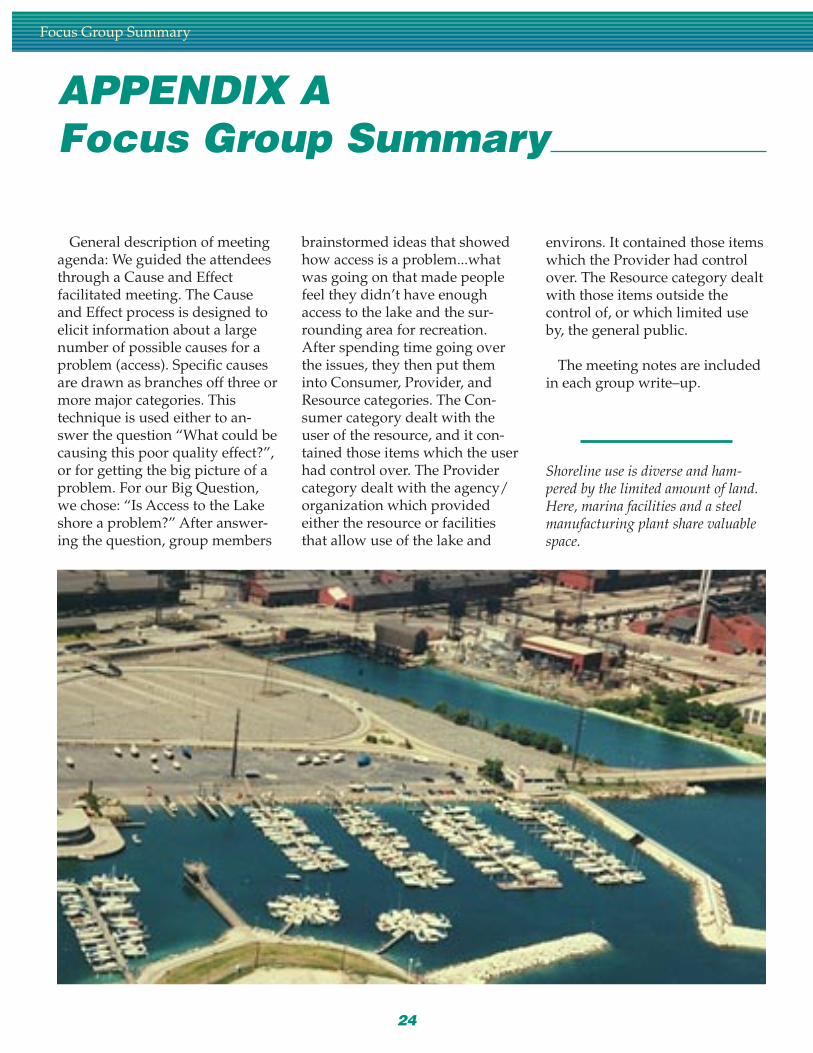
Shoreline use is diverse and ham-pered by the limited amount of land.Here, marina facilities and a steelmanufacturing plant share valuablespace.
APPENDIX AFocus Group Summary
Focus Group Summary

25
Group 1: Private marinas and other private recreation providers
This meeting was scheduled to be held April 8, 1996. No member of thepublic showed up to the meeting. Forty private recreation providers wereinvited. Since no one showed, they were also invited to the public user groupsmeeting.
Group 2: Public recreation providers
This meeting was scheduled for April 22, 1996. Eight people attended. Thiswas the first meeting we were able to have. The first decision the group madewas there were indeed lakeshore access problems. Next, they brainstormedideas and came up with several issues concerning access. Then they spent theremaining time categorizing the issues, and coming up with a few solutions tothe perceived problems.
Provider
Need more water and beach access
Difficult to find information about access—location and facilities
Inconsistent access—price, hours, security (personal safety), facilitiesoffered, policies/enforcement
Access to facilities is discriminatory to minorities (this is not intentional,though)
Lake/water fatalities are mostly minorities
Need more diversified/comprehensive access. Special access for specialuses
User conflict
Better linkages
Who is in charge
Rental facilities—pwc, boats, etc.
Non–existent signage
Lack of necessary infrastructure to get to the lakeshore
Need more partnerships with industry
Industry is responding, but public agencies are not
Governmental inflexibility (open state parks to additional access)
Duplication in planning. Lack of coordinated planning effort
Marketing duplication
Lack of scenic drives
Not enough knowledge about access for persons with disabilities
Current “disabled” access needs upgrading
Need standards for universal access
Three–county coordinated brochure
Need glossary of terms (part of brochure)
Appendix A

26
Survey ethnic cultures to see how they use the lake
Consumers
Respond to survey on how ethnic cultures use the lake
Demand standards for universal access
Demand upgraded “disabled” access
Demand/supply more knowledge about access for persons with dis-abilities
Politicians and bureaucrats are ignorant and insensitive to the issues
Too much orientation to special interests (environmentalists)
Demand more partnerships with industry
Industry is responding but providers are not
Demand more governmental flexibility (open state parks)
Demand more diversified/comprehensive access
User conflicts
Who is in charge
Demand more rental facilities—pwc, boats, etc.
Demand non–discriminatory access to facilities and hours of operation
Lake/water fatalities are mostly minorities
Demand more water and beach access
Demand consistent facilities
Resource
Need more water and beach access (limited by the total amountavailable)
Difficult to find information about the location and types of facilitiesavailable
Resource imposes limitations on more diversified/comprehensive access
User conflicts
Rental facilities—pwc, boats, etc.
Costs to provide more infrastructure for increased access
Too much industry—blocks access due to size
Lack of scenic drives
Not enough knowledge about disabled access
Group 3: Users and User Groups
This meeting was held May 6. Twenty–seven people attended. Because thiswas such a large group, they were divided into two sections: those that be-lieved there to be adequate lakeshore access and those that believed there to beinadequate lakeshore access. Each subgroup was led through the same facilita-tion process. The group members also offered some solutions to their perceivedaccess problems.
Focus Group Summary
27
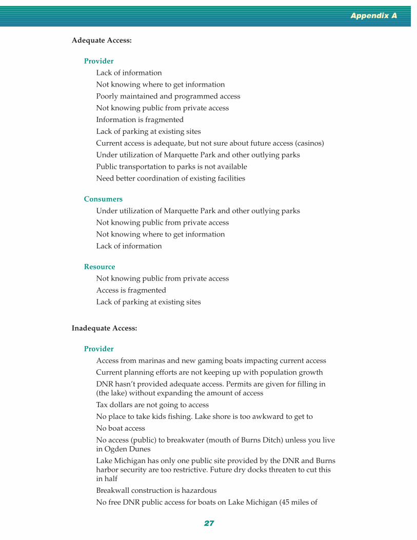
Adequate Access:
Provider
Lack of information
Not knowing where to get information
Poorly maintained and programmed access
Not knowing public from private access
Information is fragmented
Lack of parking at existing sites
Current access is adequate, but not sure about future access (casinos)
Under utilization of Marquette Park and other outlying parks
Public transportation to parks is not available
Need better coordination of existing facilities
Consumers
Under utilization of Marquette Park and other outlying parks
Not knowing public from private access
Not knowing where to get information
Lack of information
Resource
Not knowing public from private access
Access is fragmented
Lack of parking at existing sites
Inadequate Access:
Provider
Access from marinas and new gaming boats impacting current access
Current planning efforts are not keeping up with population growth
DNR hasn’t provided adequate access. Permits are given for filling in(the lake) without expanding the amount of access
Tax dollars are not going to access
No place to take kids fishing. Lake shore is too awkward to get to
No boat access
No access (public) to breakwater (mouth of Burns Ditch) unless you livein Ogden Dunes
Lake Michigan has only one public site provided by the DNR and Burnsharbor security are too restrictive. Future dry docks threaten to cut thisin half
Breakwall construction is hazardous
No free DNR public access for boats on Lake Michigan (45 miles of
Appendix A
28
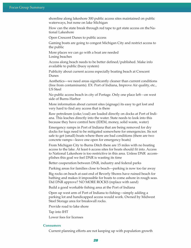
shoreline along lakeshore 300 public access sites maintained on publicwaterways, but none on lake Michigan
How can the state break through red tape to get state access on theNa-tional Lakeshore
Open Crescent Dunes to public access
Gaming boats are going to congest Michigan City and restrict access tothe public
More places we can go with a boat are neededLosing beaches
Access along beach needs to be better defined/published. Make infoavailable to public (buoy system)
Publicity about current access especially boating beach at CrescentDunes
Aesthetics—we need areas significantly cleaner than current conditions(free from contaminants). EX: Port of Indiana, Improve Air quality, etc.,US Steel
No public access beach in city of Portage. Only one place left—on westside of Burns Harbor
More information about current sites (signage) its easy to get lost andvery hard to find any access that is there
Raw petroleum (coke/coal) are loaded directly on docks at Port of Indi-ana. This leaches directly into the water. State needs to look into thisbecause they have control here (IDEM, money, solid waste, water)
Emergency ramps in Port of Indiana that are being removed for drydocks for tugs need to be mitigated somewhere for emergencies. Its notsafe to get (small) boats where there are bad conditions (there are twoconcrete ramps—leave one open for emergency boats)
From Michigan City to Burns Ditch there are 15 miles with no boatingaccess to the lake. At least 6 access sites for boats should fit into. Accessto National Lakeshore is too restrictive in this area. Unless DNR accom-plishes this goal we feel DNR is wasting its time
Better cooperation between DNR, industry and federal parks
Parking areas for families close to beach—parking is now too far away
Big rocks on beach at east end of Beverly Shores have ruined beach forbathing and makes it impossible for boats to come ashore in rough seas.Did DNR approve? NO MORE ROCKS (replace with sand)
Build a good workable fishing area at the Port of Indiana
Open up west arm of Port of Indiana to fishing—simply adding aparking lot and handicapped access would work. Owned by MidwestSteel Storage area for breakwall rocks.
Provide road to lake shore
Tap into IHT
Lower fees for licenses
Consumers
Current planning efforts are not keeping up with population growth
Focus Group Summary
29
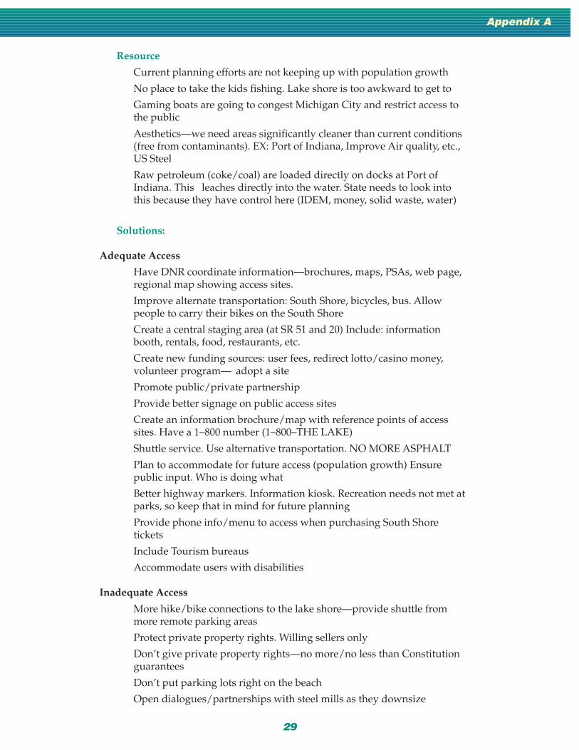
Resource
Current planning efforts are not keeping up with population growth
No place to take the kids fishing. Lake shore is too awkward to get to
Gaming boats are going to congest Michigan City and restrict access tothe public
Aesthetics—we need areas significantly cleaner than current conditions(free from contaminants). EX: Port of Indiana, Improve Air quality, etc.,US Steel
Raw petroleum (coke/coal) are loaded directly on docks at Port ofIndiana. This leaches directly into the water. State needs to look intothis because they have control here (IDEM, money, solid waste, water)
Solutions:
Adequate Access
Have DNR coordinate information—brochures, maps, PSAs, web page,regional map showing access sites.
Improve alternate transportation: South Shore, bicycles, bus. Allowpeople to carry their bikes on the South Shore
Create a central staging area (at SR 51 and 20) Include: informationbooth, rentals, food, restaurants, etc.
Create new funding sources: user fees, redirect lotto/casino money,volunteer program— adopt a site
Promote public/private partnership
Provide better signage on public access sites
Create an information brochure/map with reference points of accesssites. Have a 1–800 number (1–800–THE LAKE)
Shuttle service. Use alternative transportation. NO MORE ASPHALT
Plan to accommodate for future access (population growth) Ensurepublic input. Who is doing what
Better highway markers. Information kiosk. Recreation needs not met atparks, so keep that in mind for future planning
Provide phone info/menu to access when purchasing South Shoretickets
Include Tourism bureaus
Accommodate users with disabilities
Inadequate Access
More hike/bike connections to the lake shore—provide shuttle frommore remote parking areas
Protect private property rights. Willing sellers only
Don’t give private property rights—no more/no less than Constitutionguarantees
Don’t put parking lots right on the beach
Open dialogues/partnerships with steel mills as they downsize
Appendix A

30
Increase infrastructure (restrooms)
Require public access along gaming boat sites
Any time state tax dollars get used for Lake Michigan then free accessshould be provided
Litigation for access rights—mayors
Security at access sites (lighting)
Open facilities currently developed with tax dollars to the public
Legislation—state, local
Don’t over–develop areas that are still relatively natural to the pointthat the resource is destroyed
Crescent Cove plan
Bait and tackle shops and cleanup stations at boat access sites withtelephone, and sanitary facilities
No Crescent Cove plan. Crescent Cove is to be part of Dunes NLS
Inventory of walking easements (pre–emptive easement). Define rights.Define walking easement
Make people responsible for their actions along the lake shore—USSteel
No more regulations
Tax dollars from this area comes back to this area
Regulations are needed to clarify what rights we have under the law
When Dingel–Johnson funds are used for marinas or along shoreline—reasonable fees should be charged and anglers need access. Stop usingtheir money and then restricting access
Free up federal funds authorized for sand replacement at BeverlyShores
Raise user fees. We don’t mind paying, we just want results
Group 4: Commissions and Commissioners
This meeting was held May 20. Only two people were in attendance. Alongwith categorizing access difficulties, this group gave their opinions on whatwould be the best and worst case scenarios for lakeshore development. Thesecitizens wanted to give their vision of the “perfect” Lake Michigan shoreline.
Best Case Scenario
Provider
Continued environmental enforcement. Cleaner Lake
A restaurant overlooking the lake in each community that has room
Re–open Johnson Inn (Town of Porter)
More marinas/boating opportunities
City of Gary actually gets a marina
Focus Group Summary

31
Direct secondary routes (roads) to destinations
More mass–transit: shuttles between parks
More intermodal trails (bike/ped)
Improvement of ancillary facilities: Wolf Lake, Little Cal. River
More sanitary facilities to support development
Consistent funding source i.e., mass transit money, percent of gas tax
Public access is encouraged
Private development can move into existing bare spots to provide morerecreation opportunities
Consumers
Continued environmental enforcement. Cleaner lake
A restaurant overlooking the lake in each community that has room
Re–open Johnson Inn (Town of Porter)
More marinas/boating opportunities
City of Gary actually gets a marina
Direct secondary routes (roads) to destinations
More mass–transit: shuttles between parks
Resource
Continued environmental enforcement. Cleaner Lake
A restaurant overlooking the lake in each community that has room
Re–open Johnson Inn (Town of Porter)
Reduce the amount of private housing to increase access
More marinas/boating opportunities
City of Gary actually gets a marina
More mass–transit: shuttles between parks
More intermodal trails (bike/ped)
Improvement of ancillary facilities: Wolf Lake, Little Cal. River
More sanitary facilities to support development
Consistent funding source i.e., mass transit money, percent of gas tax
Worst Case Scenario:
Provider
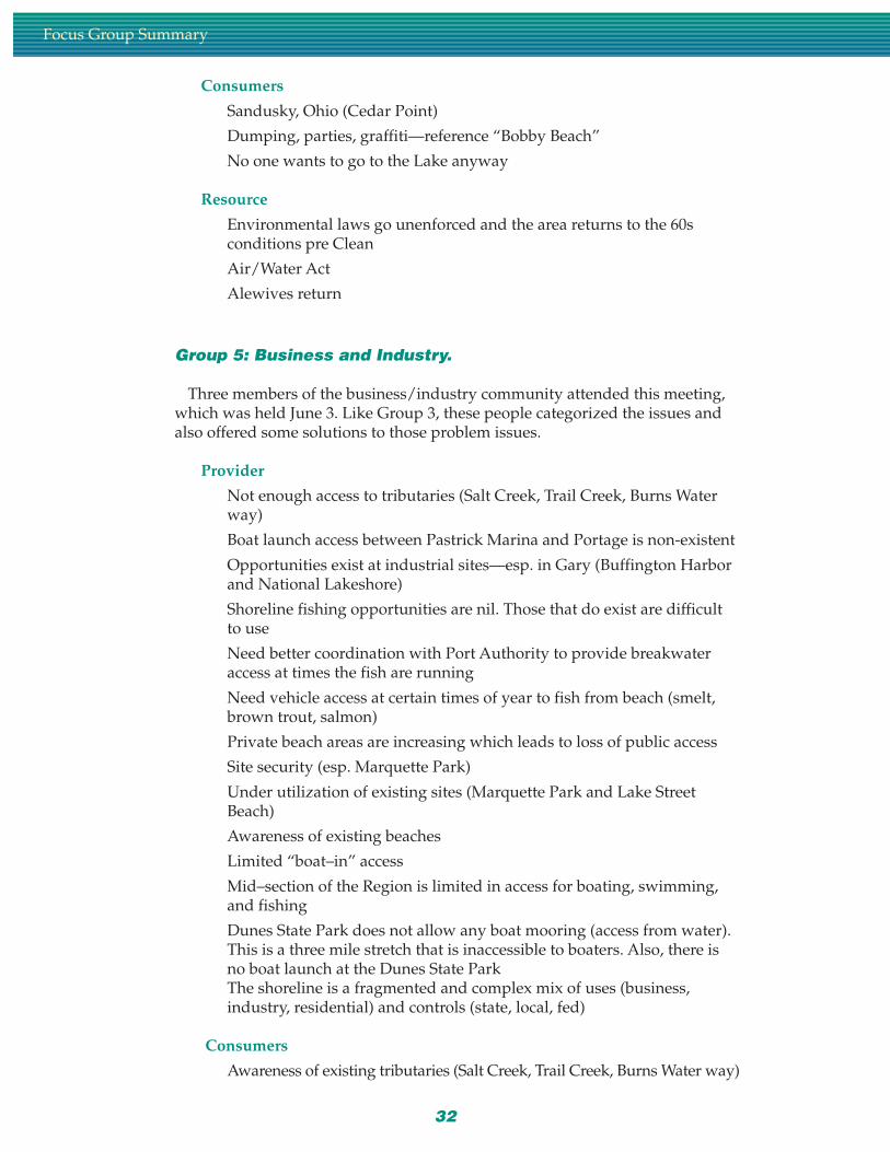
Sandusky, Ohio (Cedar Point)
Dumping, parties, graffiti—reference “Bobby Beach”
Charging for access
DNR fishing access at Port of Indiana closes
Environmental laws go unenforced and the area returns to the 60sconditions pre Clean
Air/Water Act
Appendix A
32
Consumers
Sandusky, Ohio (Cedar Point)
Dumping, parties, graffiti—reference “Bobby Beach”
No one wants to go to the Lake anyway
Resource
Environmental laws go unenforced and the area returns to the 60sconditions pre Clean
Air/Water Act
Alewives return
Group 5: Business and Industry.
Three members of the business/industry community attended this meeting,which was held June 3. Like Group 3, these people categorized the issues andalso offered some solutions to those problem issues.
Provider
Not enough access to tributaries (Salt Creek, Trail Creek, Burns Waterway)
Boat launch access between Pastrick Marina and Portage is non-existent
Opportunities exist at industrial sites—esp. in Gary (Buffington Harborand National Lakeshore)
Shoreline fishing opportunities are nil. Those that do exist are difficultto use
Need better coordination with Port Authority to provide breakwateraccess at times the fish are running
Need vehicle access at certain times of year to fish from beach (smelt,brown trout, salmon)
Private beach areas are increasing which leads to loss of public access
Site security (esp. Marquette Park)
Under utilization of existing sites (Marquette Park and Lake StreetBeach)
Awareness of existing beaches
Limited “boat–in” access
Mid–section of the Region is limited in access for boating, swimming,and fishing
Dunes State Park does not allow any boat mooring (access from water).This is a three mile stretch that is inaccessible to boaters. Also, there isno boat launch at the Dunes State ParkThe shoreline is a fragmented and complex mix of uses (business,industry, residential) and controls (state, local, fed)
Consumers
Awareness of existing tributaries (Salt Creek, Trail Creek, Burns Water way)
Focus Group Summary
33
Dunes State Park does not allow any boat mooring (access from water).This is a three mile stretch that is inaccessible to boaters. Also, there isno boat launch at the Dunes State ParkThe shoreline is a fragmented and complex mix of uses (business, industry, residential) and controls (state, local, fed)
Private beach areas are increasing which leads to loss of public access
Site security (esp. Marquette Park)
Under utilization of existing sites (Marquette Park and Lake StreetBeach)
Awareness of existing beaches
Limited “boat–in” access
Perception of safety at existing beaches
Lack of user ethics is limiting access
Shoreline fishing opportunities are nil. Those that do exist are difficultto use
You already must know what opportunities exist. There is very littleinformation available to the “outsider”
Need better coordination with Port Authority to provide breakwateraccess at times the fish are running
Resource
Dunes State Park does not allow any boat mooring (access from water).This is a three mile stretch that is inaccessible to boaters. Also, there isno boat launch at the Dunes State ParkMid–section of the Region is limited in access for boating, swimmingand fishing
Need vehicle access at certain times of year to fish from beach (smelt,brown trout, salmon)
Not enough access to tributaries (Salt Creek, Trail Creek, Burns Waterway)
Shoreline fishing opportunities are nil. Those that do exist are difficultto use
Solutions:
Produce and distribute a user friendly map
Improve the tributaries (access and fish habitat). Have catch and releasefishing, provide holding and shelter areas
Create a fish habitat stamp to provide funds to improve habitat. Earmark those funds for Northwest Indiana
Build more access sites on tributaries. Have DNR provide more in Lakeand Porter counties. Work on state/local partnerships
Encourage pwc use at Lake Street. It really isn’t suitable for a breakwa-ter/harbor, so encourage other uses
Include more fishing access sites as well as boating
Open marina and casino sites to anglers. Provide parking, lights, secu-rity on site.
Appendix A
Focus Group Summary
Coordinate with Indiana Dunes National Lakeshore to build morefacilities
Advertise new sites
Educate users on ethics
More coordination between entities to provide access
Provide boat launch ramp at the International Harbor
Open outer breakwalls to waterfowl hunting
Provide seasonal vehicular access for fishing. Limit the access to protectthe resource
Work with casinos to provide public access
Get an easement through Ogden Dunes for foot and vehicular traffic
Get National Park Service to open sites
Increase shore patrol for security. Increase the visibility of securityofficers. Need ATVs and bikes along beaches
All agencies need to cooperate on security issues
Increase lifeguard presence
Add ethics to user map. Provide trash and recycling containers andmaintain them
Improve existing sites. Get vendors to help. Get private and publicdollars for renovation and new facilities
Add Marquette Park to National Park Service jurisdiction
Put signs on the expressway advertising access sites
Get a dialogue with State Parks to get them to open Dunes State Park toboats.
Pursue other opportunities—private and local to increase access
Provide seed money to build new sites
Isolate an area for boats (at Dunes State Park) and make them pay there.
Change the “I have to make money” mentality/policy at state parks
Look at other states’ policies
Identify feasible (environmental, financial capabilities) sites, then createfinancial incentives to create facilities
Create partnerships with state, local, and business (i.e., NIPSCO gener-ating facilities) Have the state agency provide security and liability
Change current no boat policy at state park (can still disallow overnight mooring)
Build a boat launch in Dunes State Park
Encourage partnerships
Create and encourage a “Classified Beach” program. Will get tax breaksfor providing public access on private land
34
App
endi
x B
App
endi
x B Lake
MichiganAccessSurvey
LakeMichiganAccessSurvey

36
Date: Time: Location:
Please check the correct answers
1. Are you: Male Female
2. In which age group are you?17 & under 25-34 45-54 65-7418-24 35-44 55-64 75 and over
3. What is your current marital status?Single-never married Divorced WidowedMarried Separated
4. Where is your primary residence located?Indiana Illinois Other state in U.S. Other countryMichigan Wisconsin Canada
Answer question 5 only if you live in Indiana.5. In which Indiana county do you live?
Lake LaPorte Do not live in IndianaPorter Other county in Indiana
Answer question 6 only if you live in Indiana and not in Lake, Porter, or LaPorte county.6. Which Indiana city is the closest to, or is, your primary residence?
Gary/Hammond Kokomo Richmond EvansvilleSouth Bend/Elkhart Muncie/Marion Bloomington/Columbus Do not live in IndianaFort Wayne Terre Haute Lawrenceburg/MadisonLafayette Indianapolis New Albany/Clarksville
Answer question 7 only if you live in Michigan.7. In which Michigan county do you live?
Berrien county Van Buren county Do not live in MichiganCass county Other county in Michigan
Answer question 8 only if you live in Illinois.8. In which Illinois county do you live?
Cook county Lake county Other county in IllinoisWill county Kankakee county Do not live in Illinois
Answer question 9 only if you live in Wisconsin9. In which Wisconsin county do you live?
Racine county Walworth county Do not live in WisconsinKenosha county Other county in Wisconsin
Answer question 10 only if you live in the U.S. but not in Indiana, Michigan, Illinois, or Wisconsin.10. Which of the following BEST describes the area of the country where you live?
Midwest Mid Atlantic South WestNortheast Southeast Southwest Northwest
11. Are you...White/Non Hispanic Hispanic AsianBlack/African American Native American Other
Lake Michigan Access Survey
37
12. What is your annual house hold income before taxes?Under $10,000 $30,000-$39,000 $60,000-$69,999$10,000-$19,999 $40,000-$49,999 $75,000-$99,999$20,000-$29,999 $50,000-$59,999 Over $100,000
13. How many are in your group today?Just myself 3 5 9-122 4 6-8 More than 12
14. Which of the following BEST describes how often you visit this property?This is my first visit A couple of times per year Once every week or two More than onceOnce a year Several times per year Once a week a week
15. What mode of transportation did you use to get to this property today?Car/truck Bicycle Boat OtherMotorcycle Bus Walked/jogged
16. Did you experience any trouble getting to the shoreline today?Yes No Not applicable
Answer question 17 only if you answered “Yes” to 16.17. Which of the following contributed to your difficulty in reaching the shoreline today? (check all that apply)
Traffic Inconvenient boat-in areasRoad conditions Inconvenient access for swimming, fishing, etc.Difficulty in finding this site Private property restrictionsLack of or inconvenient parking Railroad crossingsLack of public transportation Car/truck troubleInconvenient boat-out/launch ramps Other
18. Which of the following activities are you participating in at this property today? (check all that apply)Power boating Boat fishing Biking CampingSail boating Skiing Driving for pleasure Canoeing/KayakingSwimming Jet skiing Hiking/walking/jogging Nature observationShore fishing Picnicking Other
19. Do you feel there is enough access at this property for SWIMMING?Yes No No opinion
20. Do you feel there is enough access at this property for FISHING?Yes No No opinion
21. Do you feel there is enough access at this property for BOATING?Yes No No opinion
22. Do you feel there is enough access at this property for other general activities such as picnicking, lakeviewing & observation, etc.?Yes No No opinion
23. Do you feel there is a need for additional public facilities at Lake Michigan? (check all that apply)Current facilities are OK Need more fishing access areasNeed more beaches for swimming, sunbathing, etc. Need more public open spaces for picnicking, etc.Need more marinas Need more boat rampsNeed more boat-in beaches Need more rental equipment such as boats, skis, etc.
Appendix B

24. Approximately how much money have you spent or expect to spend for FOOD on today’s outing?Zero $11-$15 $31-$40 $76-$100Less than $5 $16-$20 $41-$50 More than $100$5-$10 $21-$30 $51-$75
25. Approximately how much money have you spent or expect to spend for GAS on today’s outing?Zero $11-$15 $31-$40 $76-$100Less than $5 $16-$20 $41-$50 More than $100$5-$10 $21-$30 $51-$75
26. Approximately how much money have you spent or expect to spend for RENTAL FEES on today’souting?Zero $11-$15 $31-$40 $76-$100Less than $5 $16-$20 $41-$50 More than $100$5-$10 $21-$30 $51-$75
27. Is your outing today part of an extended or overnight trip?Yes No—this is just a one day trip
Answer 28, 29, & 30 only if this outing is a part of an extended or overnight trip.28. How many nights will you be away from home during this trip?
1 3 5 7 11-152 4 6 8-10 More than 15
29. Which of the following BEST describes where you are staying during this trip?Motel/hotel RV OtherCampground With friends/relatives
30. Approximately how much money have you spent or expect to spend for LODGING during this trip?Zero $31-$40 $76-$100 $201-$300Less than $20 $41-$50 $101-$150 $301-$500$20-$30 $51-$75 $151-$200 More than $500
31. Do you use access facilities to Lake Michigan in states other than Indiana?Yes No
Answer 32 & 33 only if you use access facilities to Lake Michigan in states other than Indiana.32. In which of the following areas do you use access to Lake Michigan?
Lower Michigan Wisconsin None/otherUpper Michigan Illinois
33. Which of the following BEST describes how often you use access facilities to Lake Michigan in areasoutside Indiana?Once a year A couple of times per year Several times per yearOnce every week or two Once a week More than once a week None/other
34. Of the following, please check the three MOST important to you:Good fishing Good swimming area Hiking/nature trailsNatural beauty of the area Security General clean siteWater qualityWater Quality Good picnicking areas Safety of fish consumptionUncongested boating Limiting development of lake shore
Lake Michigan Access Survey
38
App
endi
x C
App
endi
x C Indiana
RecreationFacilitiesInventoryUpdate
IndianaRecreationFacilitiesInventoryUpdate

40
Indiana Recreation Facilities Inventory Update
SITE OWNER
Name of Site Owner (if different from Managing Agency)
Mailing Address (if different from site)
City State Zip Code + 4
Phone Number
RECREATION AREA (SITE)
Name of Recreation Area (site)
Site Address/Location
City State Zip Code + 4
Phone Number Site Code
INDIANA RECREATION FACILITIES INVENTORY UPDATEDEPARTMENT OF NATURAL RESOURCES DIVISION OF OUTDOOR RECREATION
The Department of Natural Re-sources, Division of OutdoorRecreation is assembling a detailedinventory of public and privateoutdoor recreation facilities inIndiana. This inventory will help
MANAGING AGENCY OF SITE
Name of Managing Agency
Mailing Address (if different from site)
City State Zip Code + 4
Phone Number
This site has received:o LWCF Granto Indiana Waters Granto Wabash River Corridor Granto Other State/Federal Grant
Please Specify _____________________________
This Recreation Area Would Best Be Called A(Circle only one description)
1. Park/Recreation Area2. Forest3. Fish and Wildlife Area4. Dedicated Nature Preserve5. Reservoir6. Historic/Cultural Site7. Fishing/Boating Access Site8. Camping or Trailer Park9. Trail10. Marina11. Commercial/Private Fishing Lake12. Beach13. Pool14. Elementary/Secondary School Grounds15. Fairground16. Zoo17. Commercial for profit Recreation Facility18. Non-profit Recreation Facility19. Sports Complex20. Other (please describe)
Please check boxthat best applies
Is this site open to the public?o yes o no
What are the daily operating hours of this facility?From _________________to _________________
o Check if open year round
If this recreation area is not open year round, how longdoes its operating season last.
From _________________to _________________
o Facility operation times unknown
Has this site been evaluated for accessibility accordingto American Disabilities Act standards?
o yes o noAre fees collected for the use of this facility?
o yes o noAre pets allowed on this recreation area?
o yes o no
state and local recreation providersbetter plan for future recreationopportunities and markets. Weunderstand that time and staff arelimited. Please help us by com-pleting this form for each site
your agency owns and/or man-ages. For participating, we willsend you a report compiled specifi-cally for your county and/orplanning area. We appreciate yourassistance with this project.
PERSON FILLING OUT FORM
Name of Person Filling Out Survey
Titleo Field Check Date:
Commercial
Private
Public

41
Appendix C
DIRECTIONS: Please use aseparate form for each recreationarea. Place an X in all boxes thatapply to the site. When the
Property Acreage
The total number of land acres in this recreation area is: ___________________ o No facilities or developmentThe total number of water acres in this recreation area is: __________________
Convenience Facilities No Restroom facilities
Restroom facilities available: o Pit o Flush o Portable oShowers availableo Handicapped accessible showers available
Number of handicapped accessible restroom facilities
Picnic and Play Areas No Picnic or Play Areas
o Picnic shelters total number of shelters _________ o Playground(s) total number if more than 1 ______o Picnic areas total number ____ total acres _____ o Handicapped accessible playground(s)o Picnic tables ______________________________ total number if more than 1 ______o Handicapped accessible picnic table(s)___________ o Open space and/or playfieldso Handicapped accessible picnic shelter(s)
Outdoor Athletic Fields No Athletic Fields
o Softball total number __number lighted __ o Soccer total number ___number lighted ___o Baseball total number __number lighted __ o Football total number ___number lighted ___o Batting cages ______________________________ o Running track total number ___number lighted ___
Outdoor Courts No Courts
o Basketball goals total number __number lighted __ o Horseshoe total number ___number lighted ___o Tennis total number __number lighted __ o Shuffleboard total number ___number lighted ___o Volleyball total number __number lighted __ o Wall courts total number ___number lighted ___
o Golf courses number of holes ________________ o Rifle-Pistol range number of ranges ____________o Driving range number of ranges _______________ o Skeet traps total number ________________o Miniature golf ______________________________ o Archery ranges number of ranges ____________o BMX course
Golf Courses and Ranges No Courses or Ranges
question asks for numbers, placethe total number of facilities inthe space provided. If you wouldlike to include additional infor-
mation, please attach it to thisform. Questions and commentsmay be directed to the Division ofOutdoor Recreation (317) 232-4070.
42
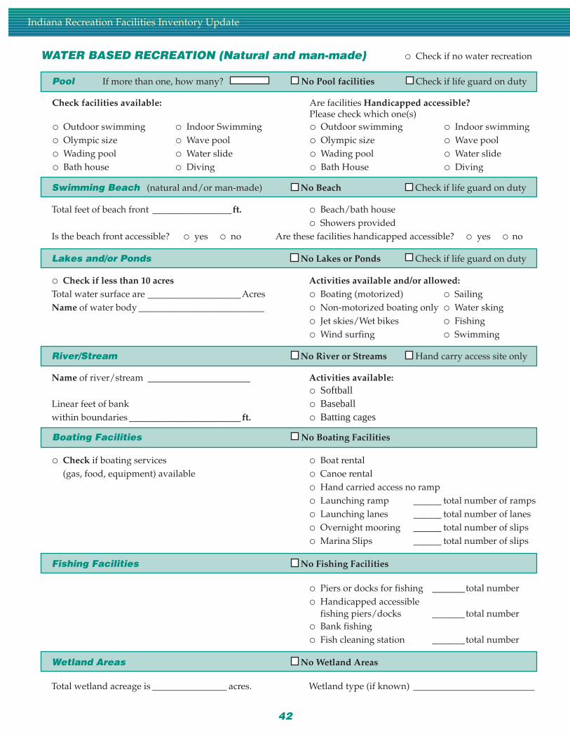
Indiana Recreation Facilities Inventory Update
WATER BASED RECREATION (Natural and man-made) o Check if no water recreation
Total feet of beach front _________________ft. o Beach/bath houseo Showers provided
Is the beach front accessible? o yes o no Are these facilities handicapped accessible? o yes o no
Check facilities available: Are facilities Handicapped accessible?Please check which one(s)
o Outdoor swimming o Indoor Swimming o Outdoor swimming o Indoor swimmingo Olympic size o Wave pool o Olympic size o Wave poolo Wading pool o Water slide o Wading pool o Water slideo Bath house o Diving o Bath House o Diving
o Check if less than 10 acres Activities available and/or allowed:Total water surface are ____________________Acres o Boating (motorized) o SailingName of water body ___________________________ o Non-motorized boating only o Water sking
o Jet skies/Wet bikes o Fishingo Wind surfing o Swimming
Name of river/stream ______________________ Activities available:o Softball
Linear feet of bank o Baseballwithin boundaries ________________________ft. o Batting cages
o Check if boating services o Boat rental(gas, food, equipment) available o Canoe rental
o Hand carried access no rampo Launching ramp ______ total number of rampso Launching lanes ______ total number of laneso Overnight mooring ______ total number of slipso Marina Slips ______ total number of slips
o Piers or docks for fishing _______total numbero Handicapped accessible
fishing piers/docks _______total numbero Bank fishingo Fish cleaning station _______total number
Total wetland acreage is ________________ acres. Wetland type (if known) __________________________
Pool If more than one, how many? No Pool facilities Check if life guard on duty
Swimming Beach (natural and/or man-made) No Beach Check if life guard on duty
Lakes and/or Ponds No Lakes or Ponds Check if life guard on duty
River/Stream No River or Streams Hand carry access site only
Boating Facilities No Boating Facilities
Fishing Facilities No Fishing Facilities
Wetland Areas No Wetland Areas
43
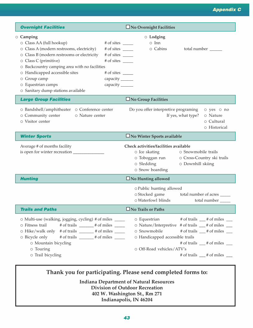
Appendix C
Overnight Facilities No Overnight Facilities
o Multi-use (walking, jogging, cycling) # of miles _____ o Equestrian # of trails ___ # of miles ___o Fitness trail # of trails _______ # of miles _____ o Nature/Interpretive # of trails ___ # of miles ___o Hike/walk only # of trails _______ # of miles _____ o Snowmobile # of trails ___ # of miles ___o Bicycle only # of trails _______ # of miles _____ o Handicapped accessible trails
o Mountain bicycling # of trails ___ # of miles ___o Touring o Off-Road vehicles/ATV’so Trail bicycling # of trails ___ # of miles ___
o Camping o Lodgingo Class AA (full hookup) # of sites _____ o Inno Class A (modern restrooms, electricity) # of sites _____ o Cabins total number ______o Class B (modern restrooms or electricity # of sites _____o Class C (primitive) # of sites _____o Backcountry camping area with no facilitieso Handicapped accessible sites # of sites _____o Group camp capacity ______o Equestrian camps capacity ______o Sanitary dump stations available
o Bandshell/amphitheater o Conference center Do you offer interpretive programing o yes o noo Community center o Nature center If yes, what type? o Natureo Visitor center o Cultural
o Historical
Average # of months facility Check activities/facilities availableis open for winter recreation _______________ o Ice skating o Snowmobile trails
o Toboggan run o Cross-Country ski trailso Sledding o Downhill skiingo Snow boarding
o Public hunting allowedo Stocked game total number of acres _____o Waterfowl blinds total number _____
Thank you for participating. Please send completed forms to:
Indiana Department of Natural ResourcesDivision of Outdoor Recreation402 W. Washington St., Rm 271
Indianapolis, IN 46204
Large Group Facilities No Group Facilities
Winter Sports No Winter Sports available
Hunting No Hunting allowed
Trails and Paths No Trails or Paths
Indiana Department of Natural ResourcesDivision of Outdoor Recreation
Division of Fish and WildlifeDivision of Water
September 1998
Under Title VI of the 1964 Civil Rights Act, Section 504 of the Rehabilitation Act of 1973, the AgeDiscrimination Act of 1975, Title IX of the Education Amendments of 1972, the U.S. Governmentprohibits discrimination on the basis of race, color, national origin, age, sex, or handicap. If you
believe that you have been discriminated against in any program, activity, or facility as describedabove, or if you desire further information please write to:
Department of Natural ResourcesExecutive Office, 402 W. Washington St., Rm W256
Indianapolis, IN 46204(317) 232-4020.
"EQUAL OPPORTUNITY EMPLOYER"
Support conservation through the Natural Resources Foundation.Donations of money or property are accepted to promote the work of IDNR. To contribute, contact the
Natural Resources Foundation, 402 W. Washington St., Indianapolis, IN 46204-2212, 317-233-4020.
Support the Indiana Heritage Trust.Buy an Environmental License Plate.
Your donation will purchase natural areas for preservation and recreation.
DNR
Printed on recycled paper.
HT 1 99 8
INDIANA
ENVIRONMENT
98