Embed Size (px)
Citation preview
The Study on Comprehensive Water Management of Musi River Basin in the Republic of Indonesia
Sector CFinal Report
JICA CTI Engineering International Co., Ltd. NIKKEN Consultants, Inc.
C - 33
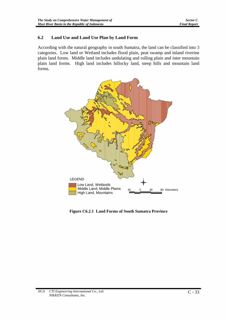
6.2 Land Use and Land Use Plan by Land Form
According with the natural geography in south Sumatra, the land can be classified into 3 categories. Low land or Wetland includes flood plain, peat swamp and inland riverine plain land forms. Middle land includes undulating and rolling plain and inter mountain plain land forms. High land includes hillocky land, steep hills and mountain land forms.
40 0 40 80 Kilometers
NLEGENDLow Land, WetlandsMiddle Land, Middle PlainsHigh Land, Mountains
Figure C6.2.1 Land Forms of South Sumatra Province
Sector C Final Report
The Study on Comprehensive Water Management ofMusi River Basin in the Republic of Indonesia
C-34 JICA CTI Engineering International Co., Ltd. NIKKEN Consultants, Inc.
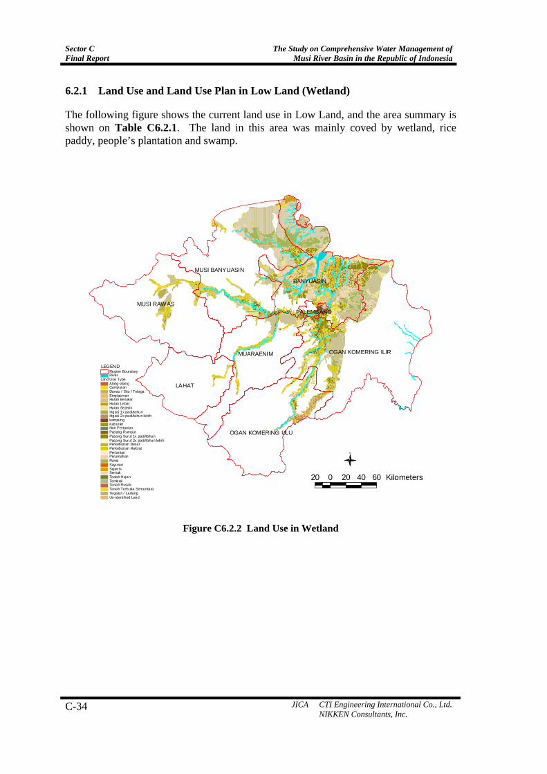
6.2.1 Land Use and Land Use Plan in Low Land (Wetland)
The following figure shows the current land use in Low Land, and the area summary is shown on Table C6.2.1. The land in this area was mainly coved by wetland, rice paddy, people’s plantation and swamp.
LAHAT
MUSI RAWAS
BANYUASIN
MUSI BANYUASIN
OGAN KOMERING ILIRMUARAENIM
OGAN KOMERING ULU
PALEMBANG
Land Use TypeAlang-alangCampuranDanau / Situ / TelagaEmplasmenHutan BelukarHutan LebatHutan SejenisIrigasi 1x padi/tahunIrigasi 2x padi/tahun lebihkampungKuburanNon PertanianPadang RumputPasang Surut 1x padi/tahunPasang Surut 2x padi/tahun lebihPerkebunan BesarPerkebunan RakyatPertanianPerumahanRawaSayuranSejenisSemakTadah HujanTambakTanah RusakTanah Terbuka SementaraTegalan / LadangUn-identif ied Land
RiverRegion Boundary
LEGEND
20 0 20 40 60 Kilometers
N
Figure C6.2.2 Land Use in Wetland
The Study on Comprehensive Water Management of Musi River Basin in the Republic of Indonesia
Sector CFinal Report
JICA CTI Engineering International Co., Ltd. NIKKEN Consultants, Inc.
C - 35
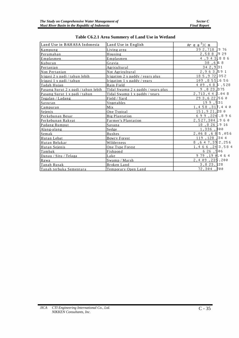
Table C6.2.1 Area Summery of Land Use in Wetland
Land Use in BAHASA Indonesia Land Use in English Area (m2)Kampung Living area 392,718,976Perumahan Housing 2,588,929Emplasmen Emplasmen 4,943,886Kuburan Gravia 38,668Pertanian Agricultural 342,931Non Pertanian Not Agricultural 2,963,591Irigasi 2 x padi / tahun lebih Irigation 2 x paddy / years plus 185,972,352Irigasi 1 x padi / tahun Irigation 1 x paddy / years 109,855,656Tadah Hujan Rain Field 409,486,528Pasang Surut 2 x padi / tahun lebih Tidal Swamp 2 x paddy / years plus 9,823,375Pasang Surut 1 x padi / tahun Tidal Swamp 1 x paddy / years 2,713,442,048Tegalan / Ladang Field / Yard 293,622,560Sayuran Vegetables 199,531Campuran Mix 1,458,317,440Sejenis One Typical 151,921,280Perkebunan Besar Big Plantation 699,224,896Perkebunan Rakyat Farmer's Plantation 2,527,304,960Padang Rumput Savana 18,826,916Alang-alang Sedge 1,336,300Semak Bushes 2,068,685,056Hutan Lebat Bowry Forest 119,128,344Hutan Belukar Wilderness 8,647,392,256Hutan Sejenis One Type Forest 1,466,243,584Tambak Fishpond 626,506Danau / Situ / Telaga Lake 979,190,464Rawa Swamp / Marsh 2,409,235,200Tanah Rusak Broken Land 3,823,128Tanah terbuka Sementara Temporary Open Land 72,304,200
Sector C Final Report
The Study on Comprehensive Water Management ofMusi River Basin in the Republic of Indonesia
C-36 JICA CTI Engineering International Co., Ltd. NIKKEN Consultants, Inc.
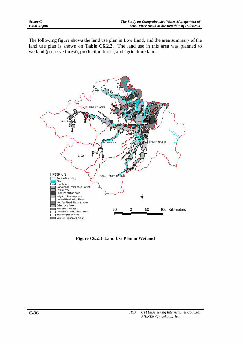
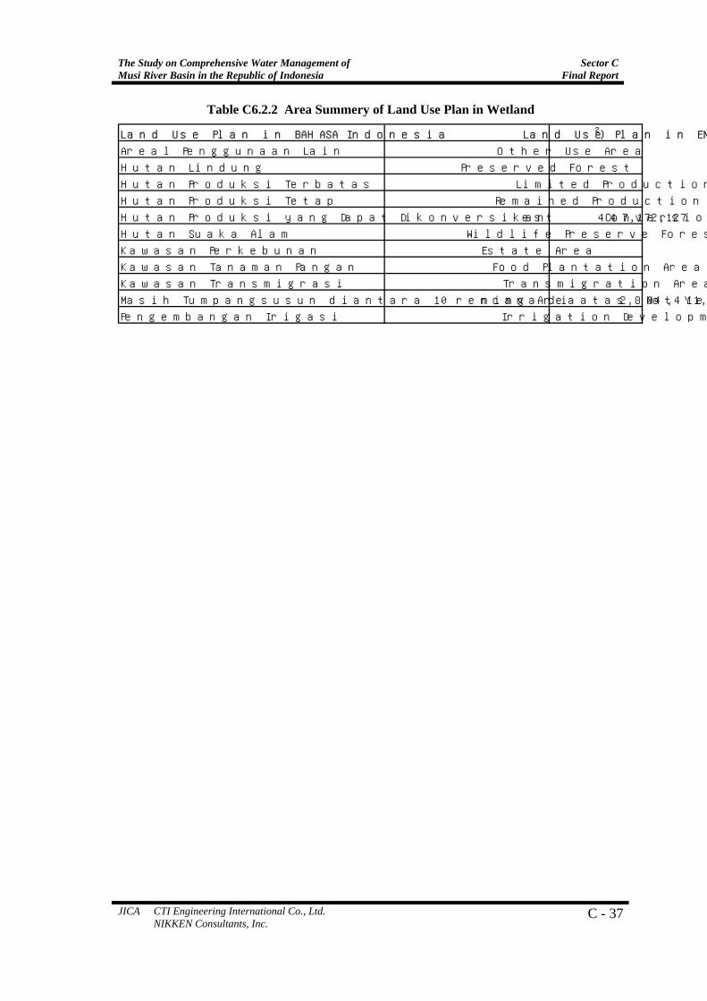
The following figure shows the land use plan in Low Land, and the area summary of the land use plan is shown on Table C6.2.2. The land use in this area was planned to wetland (preserve forest), production forest, and agriculture land.
LAHAT
MUSI RAWAS
BANYUASIN
MUSI BANYUASIN
OGAN KOMERING ILIRMUARAENIM
OGAN KOMERING ULU
PALEMBANG
Land Use TypeRiverRegion Boundary
LEGEND
50 0 50 100 Kilometers
N
Conversion Production ForestEstate AreaFood Plantation AreaIrrigation DevelopmentLimited Production ForestNot Yet Fixed Planning AreaOther Use AreaPreserved ForestRemained Production ForestTransmigration AreaWildlife Preserve Forest
Figure C6.2.3 Land Use Plan in Wetland
The Study on Comprehensive Water Management of Musi River Basin in the Republic of Indonesia
Sector CFinal Report
JICA CTI Engineering International Co., Ltd. NIKKEN Consultants, Inc.
C - 37
Table C6.2.2 Area Summery of Land Use Plan in Wetland
Land Use Plan in BAHASA Indonesia Land Use Plan in ENGLISH AREA(m2)
Areal Penggunaan Lain Other Use Area 9,281,267,194
Hutan Lindung Preserved Forest 556,223,795
Hutan Produksi Terbatas Limited Production Forest 87,618,114
Hutan Produksi Tetap Remained Production Forest 3,714,719,163
Hutan Produksi yang Dapat Dikonversikan Conversion Production Forest 447,172,127
Hutan Suaka Alam Wildlife Preserve Forest 2,172,191,685
Kawasan Perkebunan Estate Area 1,614,680,228
Kawasan Tanaman Pangan Food Plantation Area 2,432,918,519
Kawasan Transmigrasi Transmigration Area 1,447,690,243
Masih Tumpangsusun diantara 10 rencana di atas Not Yet Fixed Planning Area 2,804,411,151
Pengembangan Irigasi Irrigation Development 188,609,528
Sector C Final Report
The Study on Comprehensive Water Management ofMusi River Basin in the Republic of Indonesia
C-38 JICA CTI Engineering International Co., Ltd. NIKKEN Consultants, Inc.
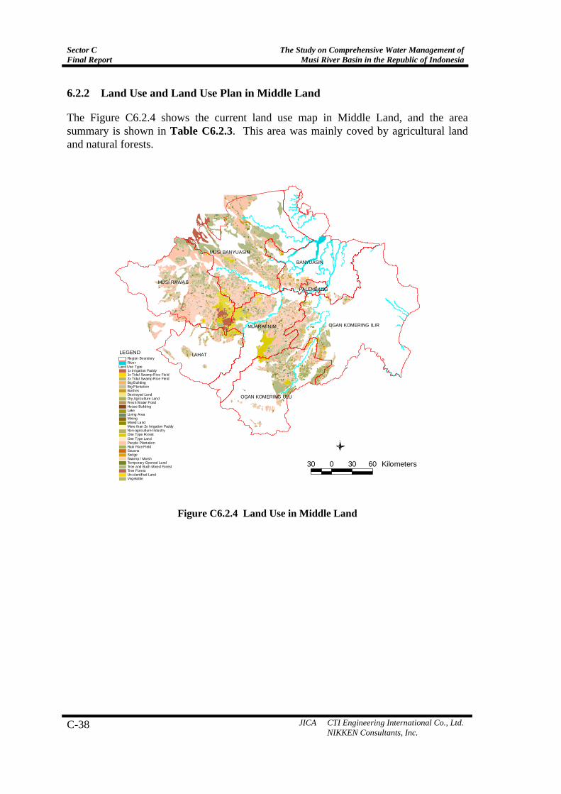
6.2.2 Land Use and Land Use Plan in Middle Land
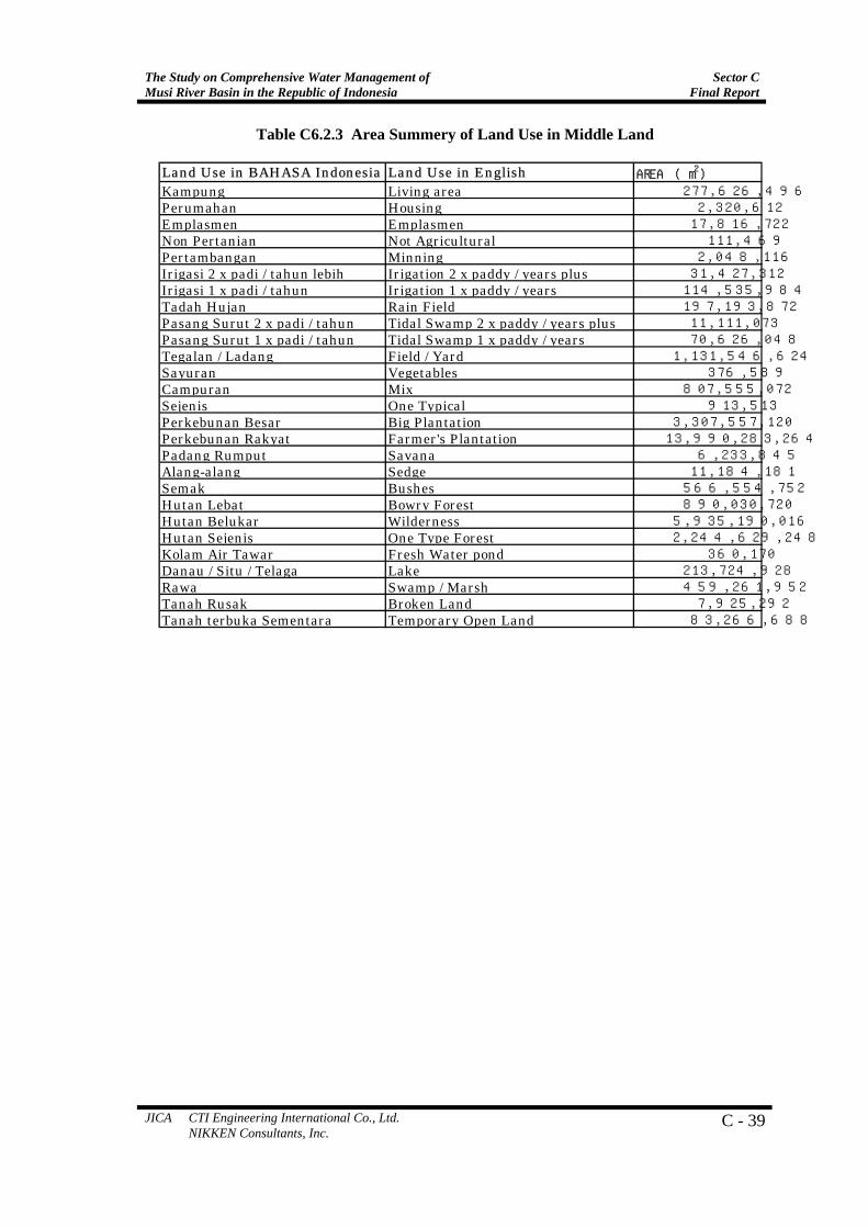
The Figure C6.2.4 shows the current land use map in Middle Land, and the area summary is shown in Table C6.2.3. This area was mainly coved by agricultural land and natural forests.
LAHAT
MUSI RAWAS
BANYUASIN
MUSI BANYUASIN
OGAN KOMERING ILIRMUARAENIM
OGAN KOMERING ULU
PALEMBANG
Land Use Type1x Irrigation Paddy1x Tidal Swamp Rice Field2x Tidal Swamp Rice FieldBig BuildingBig PlantationBushesDestroyed LandDry Agriculture LandFresh Water PondHouse BuildingLakeLiving AreaMiningMixed LandMore than 2x I rrigation PaddyNon-agriculture IndustryOne Type ForestOne Type LandPeople PlantationRain Rice FieldSavanaSedgeSwamp / MarshTemporary Opened LandTree and Bush Mixed ForestTree ForestUn-ident if ied LandVegetable
RiverRegion Boundary
LEGEND
30 0 30 60 Kilometers
N
Figure C6.2.4 Land Use in Middle Land
The Study on Comprehensive Water Management of Musi River Basin in the Republic of Indonesia
Sector CFinal Report
JICA CTI Engineering International Co., Ltd. NIKKEN Consultants, Inc.
C - 39
Table C6.2.3 Area Summery of Land Use in Middle Land
Land Use in BAHASA Indonesia Land Use in English AREA (m2)Kampung Living area 277,626,496Perumahan Housing 2,320,612Emplasmen Emplasmen 17,816,722Non Pertanian Not Agricultural 111,469Pertambangan Minning 2,048,116Irigasi 2 x padi / tahun lebih Irigation 2 x paddy / years plus 31,427,312Irigasi 1 x padi / tahun Irigation 1 x paddy / years 114,535,984Tadah Hujan Rain Field 197,193,872Pasang Surut 2 x padi / tahun Tidal Swamp 2 x paddy / years plus 11,111,073Pasang Surut 1 x padi / tahun Tidal Swamp 1 x paddy / years 70,626,048Tegalan / Ladang Field / Yard 1,131,546,624Sayuran Vegetables 376,589Campuran Mix 807,555,072Sejenis One Typical 913,513Perkebunan Besar Big Plantation 3,307,557,120Perkebunan Rakyat Farmer's Plantation 13,990,283,264Padang Rumput Savana 6,233,845Alang-alang Sedge 11,184,181Semak Bushes 566,554,752Hutan Lebat Bowry Forest 890,030,720Hutan Belukar Wilderness 5,935,190,016Hutan Sejenis One Type Forest 2,244,629,248Kolam Air Tawar Fresh Water pond 360,170Danau / Situ / Telaga Lake 213,724,928Rawa Swamp / Marsh 459,261,952Tanah Rusak Broken Land 7,925,292Tanah terbuka Sementara Temporary Open Land 83,266,688
Sector C Final Report
The Study on Comprehensive Water Management ofMusi River Basin in the Republic of Indonesia
C-40 JICA CTI Engineering International Co., Ltd. NIKKEN Consultants, Inc.
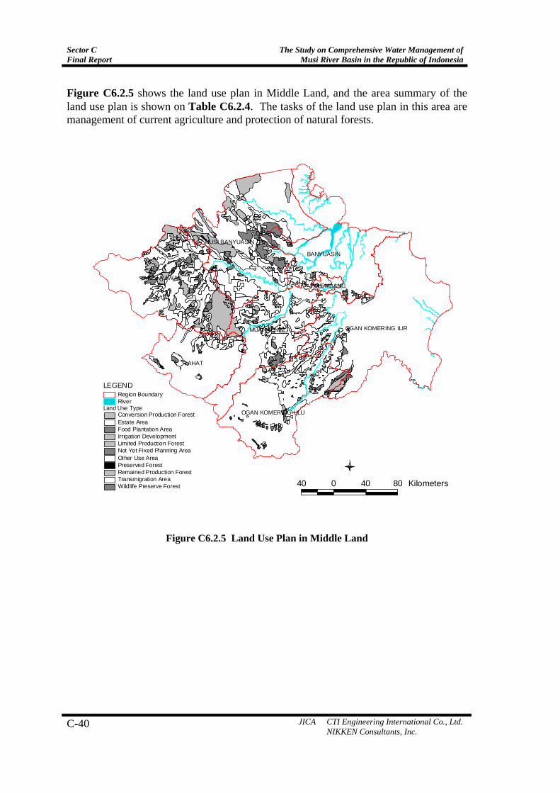
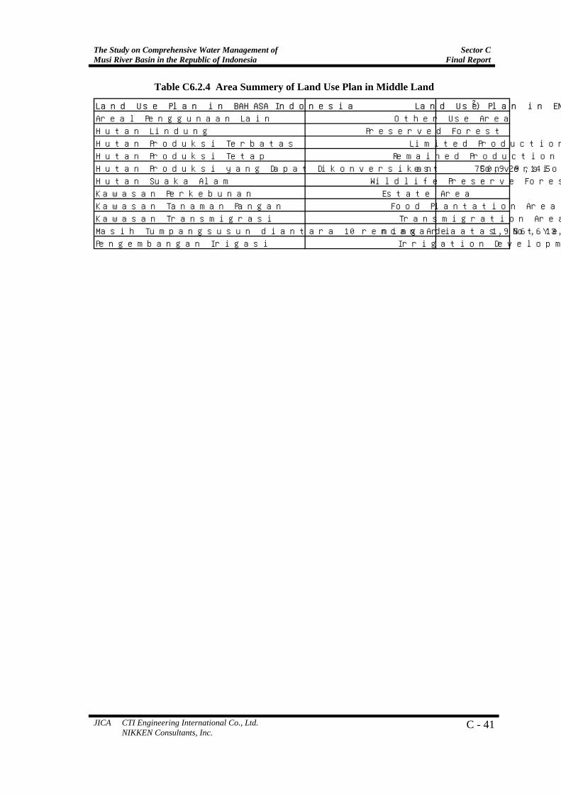
Figure C6.2.5 shows the land use plan in Middle Land, and the area summary of the land use plan is shown on Table C6.2.4. The tasks of the land use plan in this area are management of current agriculture and protection of natural forests.
LAHAT
MUSI RAWAS
BANYUASIN
MUSI BANYUASIN
OGAN KOMERING ILIRMUARAENIM
OGAN KOMERING ULU
PALEMBANG
40 0 40 80 Kilometers
N
Land Use TypeConversion Production ForestEstate AreaFood Plantation AreaIrrigation DevelopmentLimited Production ForestNot Yet Fixed Planning AreaOther Use AreaPreserved ForestRemained Production ForestTransmigration AreaWildlife Preserve Forest
RiverRegion Boundary
LEGEND
Figure C6.2.5 Land Use Plan in Middle Land
The Study on Comprehensive Water Management of Musi River Basin in the Republic of Indonesia
Sector CFinal Report
JICA CTI Engineering International Co., Ltd. NIKKEN Consultants, Inc.
C - 41
Table C6.2.4 Area Summery of Land Use Plan in Middle Land
Land Use Plan in BAHASA Indonesia Land Use Plan in ENGLISH AREA(m2)
Areal Penggunaan Lain Other Use Area 12,668,450,458
Hutan Lindung Preserved Forest 48,880,198
Hutan Produksi Terbatas Limited Production Forest 512,730,955
Hutan Produksi Tetap Remained Production Forest 3,897,636,497
Hutan Produksi yang Dapat Dikonversikan Conversion Production Forest 750,929,145
Hutan Suaka Alam Wildlife Preserve Forest 527,040,411
Kawasan Perkebunan Estate Area 5,229,944,935
Kawasan Tanaman Pangan Food Plantation Area 578,924,046
Kawasan Transmigrasi Transmigration Area 2,343,409,087
Masih Tumpangsusun diantara 10 rencana di atas Not Yet Fixed Planning Area 1,956,613,344
Pengembangan Irigasi Irrigation Development 461,392,446

Sector C Final Report
The Study on Comprehensive Water Management ofMusi River Basin in the Republic of Indonesia
C-42 JICA CTI Engineering International Co., Ltd. NIKKEN Consultants, Inc.
6.2.3 Land Use and Land Use Plan in High Land
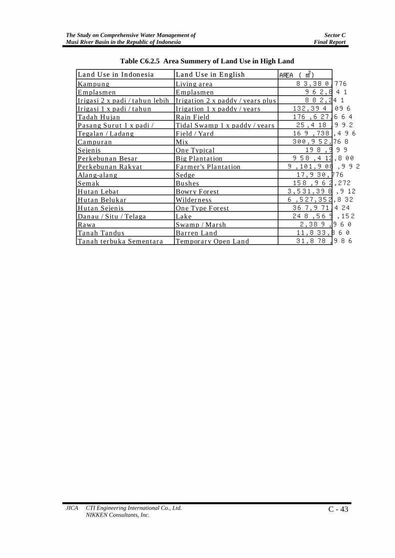
Figure C6.2.6 shows the current land use map in High Land, and the area summary is shown in Table C6.2.5. This area was mainly coved by people plantation (sort of coffee trees), and natural forests.
LAHAT
MUSI RAWAS
BANYUASIN
MUSI BANYUASIN
OGAN KOMERING ILIRMUARAENIM
OGAN KOMERING ULU
PALEMBANG
Land Use Type1x Irrigation Paddy1x Tidal Swamp Rice FieldBig BuildingBig PlantationBushesDestroyed LandDry Agriculture LandLakeLiving AreaMixed LandMore than 2x Irrigation PaddyOne Type ForestOne Type LandPeople PlantationRain Rice FieldSedgeSwamp / MarshTemporary Opened LandTree and Bush Mixed ForestTree ForestUn-identified Land
RiverRegion Boundary
LEGEND
40 0 40 80 Kilometers
N
Figure C6.2.6 Land Use in High Land
The Study on Comprehensive Water Management of Musi River Basin in the Republic of Indonesia
Sector CFinal Report
JICA CTI Engineering International Co., Ltd. NIKKEN Consultants, Inc.
C - 43
Table C6.2.5 Area Summery of Land Use in High Land
Land Use in Indonesia Land Use in English AREA (m2)Kampung Living area 83,380,776Emplasmen Emplasmen 962,841Irigasi 2 x padi / tahun lebih Irigation 2 x paddy / years plus 882,241Irigasi 1 x padi / tahun Irigation 1 x paddy / years 132,394,096Tadah Hujan Rain Field 176,627,664Pasang Surut 1 x padi / Tidal Swamp 1 x paddy / years 25,418,992Tegalan / Ladang Field / Yard 169,738,496Campuran Mix 300,952,768Sejenis One Typical 198,999Perkebunan Besar Big Plantation 958,412,800Perkebunan Rakyat Farmer's Plantation 9,101,908,992Alang-alang Sedge 17,930,776Semak Bushes 158,962,272Hutan Lebat Bowry Forest 3,531,398,912Hutan Belukar Wilderness 6,527,352,832Hutan Sejenis One Type Forest 367,971,424Danau / Situ / Telaga Lake 248,569,152Rawa Swamp / Marsh 2,389,960Tanah Tandus Barren Land 11,833,860Tanah terbuka Sementara Temporary Open Land 31,878,986
Sector C Final Report
The Study on Comprehensive Water Management ofMusi River Basin in the Republic of Indonesia
C-44 JICA CTI Engineering International Co., Ltd. NIKKEN Consultants, Inc.
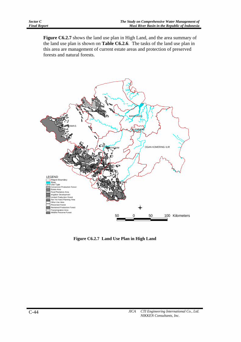
Figure C6.2.7 shows the land use plan in High Land, and the area summary of the land use plan is shown on Table C6.2.6. The tasks of the land use plan in this area are management of current estate areas and protection of preserved forests and natural forests.
LAHAT
MUSI RAWAS
BANYUASIN
MUSI BANYUASIN
OGAN KOMERING ILIRMUARAENIM
OGAN KOMERING ULU
PALEMBANG
50 0 50 100 Kilometers
N
Land Use TypeRiverRegion Boundary
LEGEND
Conversion Production ForestEstate AreaFood Plantation AreaIrrigation DevelopmentLimited Production ForestNot Yet Fixed Planning AreaOther Use AreaPreserved ForestRemained Production ForestTransmigration AreaWildlife Preserve Forest
Figure C6.2.7 Land Use Plan in High Land
The Study on Comprehensive Water Management of Musi River Basin in the Republic of Indonesia
Sector CFinal Report
JICA CTI Engineering International Co., Ltd. NIKKEN Consultants, Inc.
C - 45
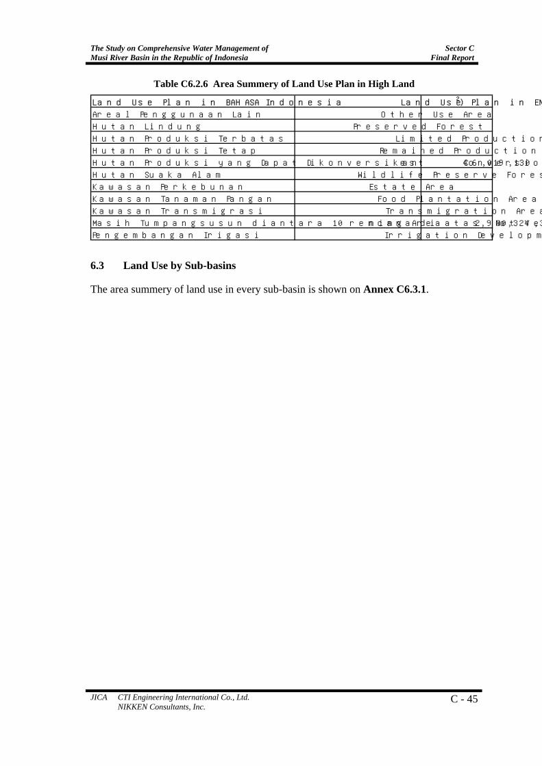
Table C6.2.6 Area Summery of Land Use Plan in High Land
6.3 Land Use by Sub-basins
The area summery of land use in every sub-basin is shown on Annex C6.3.1.
Land Use Plan in BAHASA Indonesia Land Use Plan in ENGLISH AREA(m2)
Areal Penggunaan Lain Other Use Area 5,191,436,248
Hutan Lindung Preserved Forest 2,392,267,500
Hutan Produksi Terbatas Limited Production Forest 1,249,695,182
Hutan Produksi Tetap Remained Production Forest 1,319,369,537
Hutan Produksi yang Dapat Dikonversikan Conversion Production Forest 46,019,130
Hutan Suaka Alam Wildlife Preserve Forest 3,369,313,249
Kawasan Perkebunan Estate Area 2,925,544,336
Kawasan Tanaman Pangan Food Plantation Area 328,840,827
Kawasan Transmigrasi Transmigration Area 278,840,310
Masih Tumpangsusun diantara 10 rencana di atas Not Yet Fixed Planning Area 2,900,324,340
Pengembangan Irigasi Irrigation Development 71,318,982