Embed Size (px)
Citation preview
Forest Hydrology and Watershed Management - HydrologieForestiere et Amenagement des Bassins Hydrologiques{Proceedings of the Vancouver Symposium, August 1987; Actesdu Co11oque de Vancouver, Aout 1987):IAHS-AISHPub1.no.167,1987.
Acid buffering in lowland forestedecosystems: a case study in the Trent basin,UK
IAN D. L. FOSTER
Geography Department, Coventry Polytechnic,Priory St., Coventry CVl 5FB, UK
ABSTRACT Studies of the impact of acid precipitation onnatural waters frequently concentrate on upland hard rockenvironments which usually illustrate a dramatic responsein terms of water quality and ecological deterioration.Less well documented, especially in the UK, are riverbasins which receive acid inputs but where river watersremain at or above a neutral pH. This paper presentsresults from a monitoring programme undertaken in theEnglish Midlands. It is an area which, has recorded meanmonthly rainfall pH below 5.0 for 7 months of the year,dropping to pH 4.5 in February. Canopy drip in a broadleaved oak woodland has an average annual pH of 4.1.Soil water samples extracted from the unsaturated zoneclosely mirror throughfall pH and show little bufferingof acid inputs. Low pH values are not recorded in riverand lake water samples collected in the same area, wherepH lies between 7 and 7.5.
Le pouvoir tampon dans les ecosystemes forestiers desbasses terres: une etude de cas dans le bassin de la
Trent, Royaume UniRESUME Les etudes d'impact des precipitations acidessur les eaux naturelIes sont souvent effectuees dans leshautes terres rocailleuses, environnements qui offrentdes reponses dramatiques en terme de qualite de l'eau etde deterioration ecologique. Moins bien documentes,specialement au Royaume Uni, sont les bassins recevantdes depositions acides, mais dont les rivieres demeurentneutres. Cet article presente les resultats d'unprogramme de controle mis sur pied dans les terrescentrales anglaises. Les precipitations de cette zoneont un pH moyen mensuel sous 5.0 durant 7 mois del'annee, allant jusqu'a 4.5 en fevrier. L'eau degoutantdes cimes dans un boise de chene a feuilles larges a un
pH moyen annuel de 4.1. L'eau du sol en zone non satureereflete ces valeurs et ne tamponne que tres peu ces
intrants acides. Cependant, des echantillons d'eaulacset rivieres avoisinnantes montrent un pH de 7 a
de7.5.
49
50 Ian D.L. Foster
INTRODUCTION
In a recent report dealing with acidity in United Kingdom FreshWaters (Anon, 1986), an attempt has been made to identify thoseareas where river water chemistry is most susceptible to acid raininputs. Not surprisingly, the fourfold classification producedreflects the Geology of the British Isles and classifies graniticand acid igneous rocks, grits and decalcified sands as being mostsusceptible and limestones and chalks as least susceptible to acidinputs due to an almost infinite buffering capacity. Those areassuffering most impact do not necessarily correspond to the regionsof greatest proton loading (Likens et al., 1979) since the overallimpact reflects the balance of loading and buffering ability. Anumber of studies have highlighted various aspects of acid rainimpact including the interaction with forest ecosystems (cf. Smith,1978; Dochinger & Seliga, 1976) and, more recently, the geochemicaland pedological consequences of acid loading in a range of environ-ments (Edmunds & Coe, 1986; Bricker, 1986; and Cresser et al.,1986). As emphasised by Hornung et al. (1986), understanding of theimpact of acid rain on pedological and hydrological systems demandsanalysis of input-output data and of proton sources and sinks.
The present study aims to evaluate proton sources, sinks andtransformations in the Midland region of England with special refer-ence to an analysis of hydrological pathways in a mixed oak forestecosystem in a small headwater tributary of the River Anker, whichforms part of the Trent Basin. The study seeks to answer the fol-lowing questions:
(a) What pH levels are currently found in the Midland region andwhat are the dominant acid related anions?
(b) Does a forest canopy significantly increase the protonloading to a forested environment and if so does the increasedacidity result from organic or strong acids?
(c) Does the proton loading significantly increase weatheringrates in the catchment?
(d) Can the soil/groundwater system buffer the acid inputs andif so what pedological/hydrological processes control the protonsinks?
(e) What are the possible implications of enhanced proton load-ing upon downstream water chemistry?
The data base
Long term records of atmospheric dust fallout in the UK are collatedby the Department of Environment Laboratory at Warren Springs.These data are derived from a deposit gauge network where thegauges, of around 300 mm dia, are open to atmospheric inputs con-tinuously and therefore combine wet and dry deposition (BSI, 1969).Although not usually published with dust fallout statistics, pHrecords are also available for many of the stations. Historicalrecords of pH were obtained from this data base for 12 stations inand around the city of Coventry (Environmental Health Dept.Coventry, UK; pers. comm.) in the West Midland region to supplementthose records collected in a small afforested drainage basin where
Acid buffering in forested ecosystems 51
detailed records of precipitation, soil and streamwater chemistrywere obtained for the period 1979-1983.
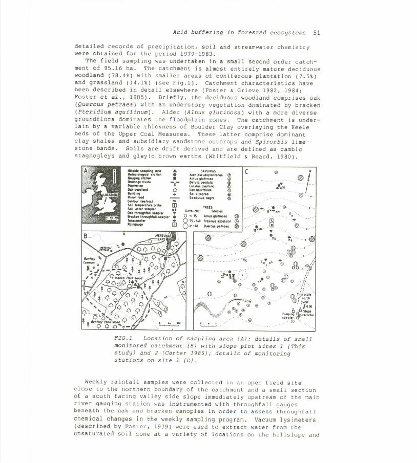
The field sampling was undertaken in a small second order catch-ment of 95.16 ha. The catchment is almost entirely mature deciduouswoodland (78.4%) with smaller areas of coniferous plantation (7.5%)and grassland (14.1%) (see Fig.l). Catchment characteristics havebeen described in detail elsewhere (Foster & Grieve 1982, 1984;Foster et al., 1985). Briefly, the deciduous woodland comprises oak(Quercus petraea) with an understory vegetation dominated by bracken(pteridium aquilinum). Alder (Alnus glutinosa) with a more diversegroundflora dominates the floodplain zones. The catchment is under-lain by a variable thickness of Boulder Clay overlaying the Keelebeds of the Upper Coal Measures. These latter comprise dominantclay shales and subsidiary sandstone outcrops and Spirorbis lime-stone bands. Soils are drift derived and are defined as cambic
stagnogleys and gleyic brown earths (Whitfield & Beard, 1980).
Hililid. ling zonoIItlton>logico' ltolionGouging ltolionOtoInogt dl.id.PlontolionOak-'ond""I!dlngMinotroodContourtNlrll1 ' "',Soli ,"_rotor. probt IIISoilwaitt"11910, . 6OakItIroughloU...pt... ~IIrockln thlOOfhfoll ...plor .TonsioNlor .RGln\IGU9I 00
4..-.-Q..
SAPLINGSAm plludopianlanul <t>Ainul glutlnola @Betula Plndulo @(or,lu. ...lIana (i)II" aqulfol/u. (i)Sol/. ,ap..o iii>SO.bu,u. ntgro <D
( ~
....10@ /
H
".., ....
@""
,,@
,@.".~, "0
'09"" 8'.'7 11 ",.." ,
"~ "'~''. ,R @"12'" ..~6'r9.@
~"'.',,11).., ,J"
. .' Of) /.J" <D :ffi (j)/k'
S..O'/>V~Of)° ' ,.,:
QJr " ,'/i" ,
if" Thi~ plait '
"'fu)Y'.nol'"
: :;;008 8 Slog.
Puop;ng 0-.'''on2...aopier, ,()"
,(i) ",
TREESGirth ('01 Sptclt.
0 < 7S Ainu. gtutino.. I1b
875-1100fro.lnul ",,1';01 @> 1100 Outreu. Pllra.a ~
~',.'
',',~..' ""5
..""" (i)
"ji.~~~:' , ',: .(j)
(!) 1J~ '.., 1"- <1J)!DO ,?<!> (j) 00
<1J)0 @
~FLO'" @\ (j) @ @
@@ @@ ,@
. . .~, @
FIG.1 Location of sampling area (A); details of smallmonitored catchment (B) with slope plot sites l (Thisstudy) and 2 (Carter 1985); details of monitoringstations on site l (C).
Weekly rainfall samples were collected in an open field siteclose to the northern boundary of the catchment and a small sectionof a south facing valley side slope immediately upstream of the mainriver gauging station was instrumented with throughfall gaugesbeneath the oak and bracken canopies in order to assess throughfa11
chemical changes in the weekly sampling program. Vacuum lysimeters(described by Foster, 1979) were used to extract water from the
unsaturated soil zone at a variety of locations on the hillslope and
52 Ian D.L. Foster
a shallow borehole was sampled for part of the period of investiga-tion (Fig.lC). River water sampleswere collectedweeklyby handand more frequently using automatic samplers. Rating curves of theform:
C = aQ-b ( 1)
where C = solute concentration; Q = stream discharge; and a and bare constants; and were used to determine the flow dependent rela-tionship for individual solute concentrations. In association withthese relationships, discharge records were used to predict con-centration and the product of concentration and flow were used tocalculate solute loadings and output budgets (cf Foster & Grieve,1984) .
Precipitation acidity in the Midland Region
In a survey of rainfall acidity data throughout the UK, based uponthe deposit gauge records collated by the Department of the Environ-ment, Martin (1979) concluded that the greatest rainwater acidityvalues occur in winter months at sites on the outskirts of towns in
Midland England. In about 33% of the sites, Martin identified thatchanges in rainwater acidity in the UK over the last 50 years hasbeen significant, increasing by about 2% per year at most sites overthe period 1928 to 1957 with no significant trends in the acidcontent up to 1976. In the Midland data, Martin suggested that therainfall acidity may also reflect the amount of chloride emittedfrom domestic coals as hydrogen chloride although some chloride mayalso derive from power station coal combustion (Martin, pers.comm.) .
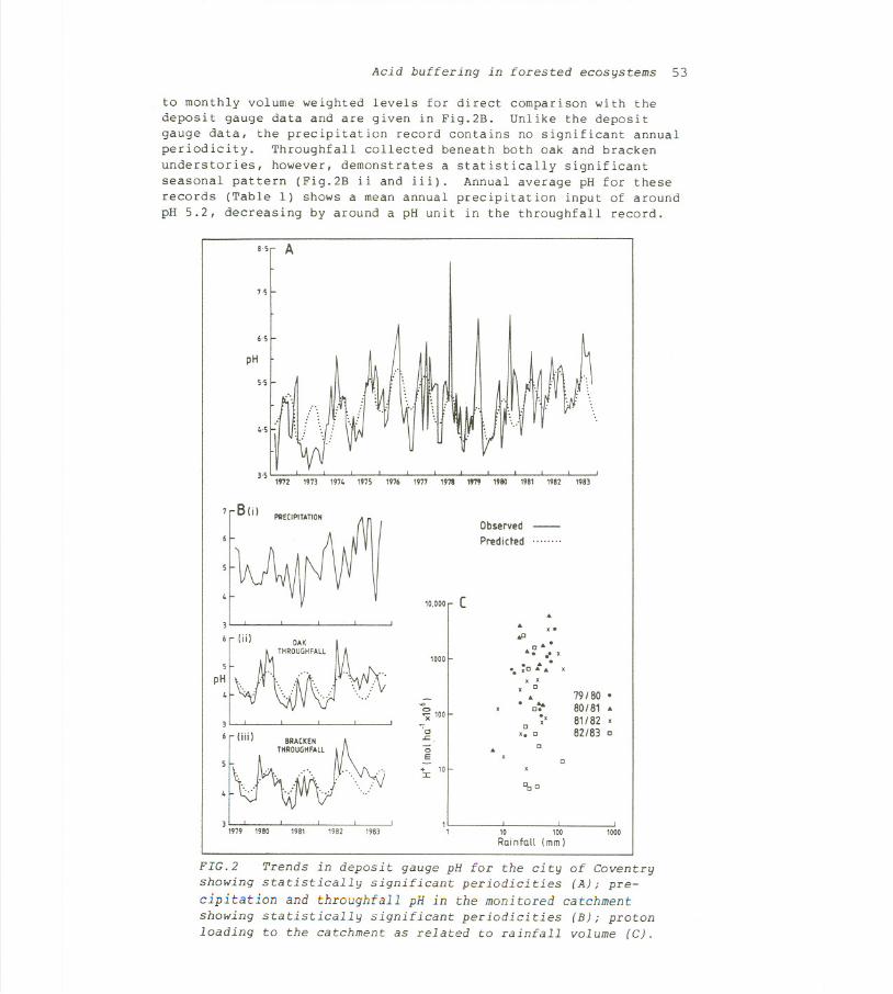
A recent compilation of Midland data based upon records availablein and around the city of Coventry has generally confirmed thefindings of Martin. From 12 deposit gauges pH values over periodsranging from 3 to 12 years up to 1983 range from 4.4 in city mar-ginal locations to over 5 at sites in the urban area. The longestof these records shown in Fig.2A, illustrates a well documented andstatistically significant seasonal pattern. This seasonality issuperimposed upon a statistically significant longer term cycle witha periodicity of 10 years. No long term trend of increase or de-crease is detectable within this data set. Minimum values are
recorded in the winter months (February Mean pH 4.5) with maximumvalues in the summer (June and July pH 5.6).
Although deposit gauge data provide some indication of long termtrends, identification of the major acid forming elements is notpossible since these data are generally not available. Furthermore,copper sulphate is usually added to the gauges as a mould inhibitorand will depress pH significantly in months with low rainfall vol-umes. Despite these problems, the long term trends and averagespresented above are probably close to the actual values (cf Martin,1979) .
A shorterrecordof precipitationyears 1979 to 1983 is available fromment (Fig.l). These data, although,
and throughfall pH for thethe small experimental catch-collected weekly, were adjusted
Acid buffering in forested ecosystems 53
to monthly volume weighted levels for direct comparison with thedeposit gauge data and are given in Fig.2B. Unlike the depositgauge data, the precipitation record contains no significant annualperiodicity. Throughfall collected beneath both oak and brackenunderstories, however, demonstrates a statistically significantseasonal pattern (Fig.2B ii and iii). Annual average pH for theserecords (Table 1) shows a mean annual precipitation input of aroundpH 5.2, decreasing by around a pH unit in the throughfall record.
8-S A
7i
6-S
pH
Mn
7 8(i) ~ro~ill~
3
6 (ii)
31979 1980 1981 1982 1983
''''.- ..
1976 1978 1979 1980 198319811977 1982
ObservedPredicted
10,000 (..
..,.
IP
1000
.. .
..;' .. x. ..'
.. XC"" xx x
x C..
. ....C.'xx
79/80
80/81 ..
81/82 x
82/83 c
~
~100
'".c-
cx.C
0E
+ 10:r:
C
C
"oC
11 10 100
Rainfall (mm)1000
FIG.2 Trends in deposit gauge pH for the city of Coventryshowing statistically significant periodicities (A); pre-cipitation and throughfall pH in the monitored catchmentshowing statistically significant periodicities (B); protonloading to the catchment as related to rainfall volume (C).
54 Ian D.L. Foster
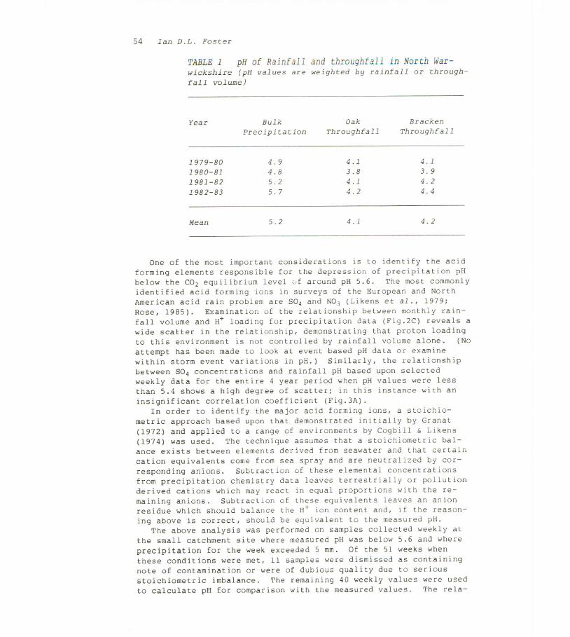
TABLE 1 pH of Rainfall and throughfall in North War-wickshire (pH values are weighted by rainfall or through-fall volume)
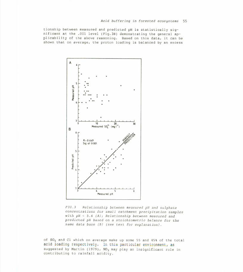
One of the most important considerations is to identify the acidforming elements responsible for the depression of precipitation pHbelow the CO2 equilibrium level (Jfaround pH 5.6. The most commonlyidentified acid forming ions in surveys of the European and NorthAmerican acid rain problem are S04 and NO) (Likens et al., 1979;Rose, 1985). Examination of the relationship between monthly rain-fall volume and H+ loading for precipitation data (Fig.2C) reveals awide scatter in the relationship, demonstrating that proton loadingto this environment is not controlled by rainfall volume alone. (Noattempt has been made to look at event based pH data or examinewithin storm event variations in pH.) Similarly, the relationshipbetween S04 concentrations and rainfall pH based upon selectedweekly data for the entire 4 year period when pH values were lessthan 5.4 shows a high degree of scatter; in this instance with aninsignificant correlation coefficient (Fig.3A).
In order to identify the major acid forming ions, a stoichio-metric approach based upon that demonstrated initially by Granat(1972) and applied to a range of environments by Cogbill & Likens(1974) was used. The technique assumes that a stoichiometric bal-ance exists between elements derived from seawater and that certaincation equivalents come from sea spray and are neutralized by cor-responding anions. Subtraction of these elemental concentrationsfrom precipitation chemistry data leaves terrestrially or pollutionderived cations which may react in equal proportions with the re-maining anions. Subtraction of these equivalents leaves an anionresidue which should balance the H+ ion content and, if the reason-
ing above is correct, should be equivalent to the measured pH.The above analysis was performed on samples collected weekly at
the small catchment site where measured pH was below 5.6 and where
precipitation for the week exceeded 5 mm. Of the 51 weeks whenthese conditions were met, 11 samples were dismissed as containingnote of contamination or were of dubious quality due to seriousstoichiometric imbalance. The remaining 40 weekly values were used
to calculate pH for comparison with the measured values. The rela-
Year Bulk Oak Bracken
Precipitation Throughfall Throughfall
1979-80 4.9 4.1 4.11980-81 4.8 3.8 3.9
1981-82 5.2 4.1 4.2
1982-83 5.7 4.2 4.4
Mean 5.2 4.1 4.2
Acid buffering in forested ecosystems 55
tionship between measured and predicted pH is statistically sig-nificant at the .001 level (Fig.3B) demonstrating the general ap-plicability of the above reasoning. Based on this data, it can beshown that on average, the proton loading is balanced by an excess
A
...
. ..
::s:
...
."
~;I
. ...
.. ...
~
~ 5MeasuredpH
FIG.3 Relationship between measured pH and sulphateconcentrations for small catchment precipitation sampleswith pH < 5.6 (A); Relationship between measured andpredicted pH based on a stoichiometric balance for the
same data base (B) (see text for explanation).
of 5°4 and Cl which on average make up some 55 and 45% of the total
acid loading respectively. In this particular environment, assuggested by Martin (1979), N03 may play an insignificant role incontributing to rainfall acidity.
30
10 2- 20 30
BMeasuredSO, (BIgr' I
6FR=0.6USigat 0.001
5::s:a.."u'ij
.t41-. ... .
./.. .
56 Ian D.L. Foster
Proton loadings, ion balances and accelerated weathering
Many drainage basin studies have shown net outputs of cations andsilica (e.g. Garrels & Mckenzie, 1971; Likens et al., 1977; Foster,1980; Reid et al., 1986; Hornung et al., 1986; Williams et al.,1986). Such data can be interpreted to indicate the predominantforms of chemical denudation taking place in a drainage basin al-though, as pointed out by Hornung et al. (1986), without supplemen-tary information relating to soil pH, mineralogy and soil waterchemistry, the exact source and magnitude of these weathering reac-tions are difficult to determine. Nevertheless, calculation and
analysis of solute budget data may be valuable in generalizing aboutthe rate at which artificially enhanced proton loading accelerateschemical weathering in a given environment and could be used as anindex of landscape or soil sensitivity to acid loading.
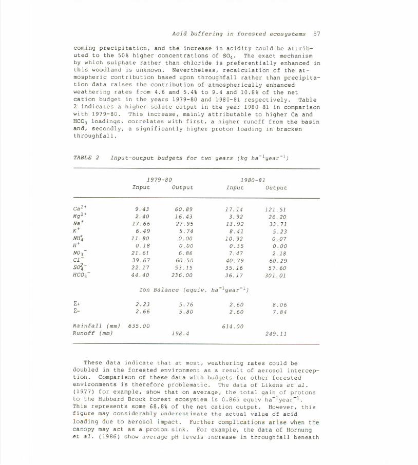
Detailed input-output budgets for two of the 4 years investigatedhave been calculated by the methods given by Foster & Grieve (1984).These data are presented in directly comparable units of input anddenudation per unit area of catchment per year (Table 2). Thevalues represent approximately steady state conditions of input andoutput in this 150 year old woodland ecosystem since no fertilizerapplications were made and thinning and forest removal were minimal.A total stoichiometric balance of reacting weight units in equiva-lents per year (Table 2) shows a fairly good cation/anion balancefor the two periods. Calcium dominates the cation denudation inthis ecosystem and, as suggested by Foster & Grieve (1984), probablyderives from the weathering of limestone bands within the carbon-iferous deposits. H+ loadings were calculated from pH values inboth precipitation and runoff. The latter, with an average pH ofc 7.5 for the two years, represents an insignificant loss. If it isassumed that the proton loading is entirely compensated by acidhydrolyzing reactions and release of basic cations, it is possibleto calculate the total chemical loading in river water derived fromacid inputs. (This is an oversimplifying assumption since processesother than weathering will act as proton sinks; Van Breemen et al.,1983.) Correction is made here for the CO2 based equilibrium rain-fall pH of 5.6 which would contribute .016 and .015 kg H+ ha-lyear-lto the region for the two years study. Of the net cationic output,enhanced acidity associated with atmospheric pollution accounts for4.6 and 5.4% of the output in 1979-80 and 1980-81 respectively.
It has already been shown that the pH of throughfall is aroundone pH unit lower than precipitation (Table 1). The above calcula-tion, however, ignores the additional contribution which may resultfrom the interception of atmospheric aerosols during periods withoutrainfall. Subsequent flushing of these aerosols from the canopy mayform a significant contribution to accelerated weathering althoughthe exact mechanisms and reactions controlling throughfall chemis-try, which will also include the leaching of nutrients, in this andother environments have yet to be established (cf Miller, 1984).Separation of strong and organic acids in throughfall was not at-tempted analytically and the stoichiometric approach applied toprecipitation data is irrelevant here since the major biogeochemicalcycles of many elements remain qualitative. However NO) and Clconcentrations in throughfall are insignificantly higher than in-
Acid buffering in forested ecosystems 57
coming precipitation, and the increase in acidity could be attrib-uted to the 50% higher concentrations of 5°4. The exact mechanismby which sulphate rather than chloride is preferentially enhanced inthis woodland is unknown. Nevertheless, recalculation of the at-
mospheric contribution based upon throughfall rather than precipita-tion data raises the contribution of atmospherically enhancedweathering rates from 4.6 and 5.4% to 9.4 and 10.8% of the net
cation budget in the years 1979-80 and 1980-81 respectively. Table2 indicates a higher solute output in the year 1980-81 in comparisonwith 1979-80. This increase, mainly attributable to higher Ca andHC03 loadings, correlates with first, a higher runoff from the basinand, secondly, a significantly higher proton loading in brackenthroughfall.
TABLE 2 Input-output budgets for two years (kg ha-lyear-l)
These data indicate that at most, weathering rates could bedoubled in the forested environment as a result of aerosol intercep-tion. Comparison of these data with budgets for other forestedenvironments is therefore problematic. The data of Likens et a1.
(1977) for example, show that on average, the total gain of protonsto the Hubbard Brook forest ecosystem is 0.865 equiv ha-lyear-l.This represents some 68.8% of the net cation output. However, thisfigure may considerably underestimate the actual value of acid
loading due to aerosol impact. Further complications arise when thecanopy may act as a proton sink. For example, the data of Hornunget a1. (1986) show average pH levels increase in throughfall beneath
1979-80 1980-81
Input Output Input Output
Ca2+ 9.43 60.89 17.14 121.51Mg2+ 2.40 16.43 3.92 26.20Na+ 17.66 27.95 13.92 33.71K+ 6.49 '5.74 8.41 5.23NEt;. 11.80 0.00 10.92 0.07H+ 0.18 0.00 0.35 0.00N03
-21.61 6.86 7.47 2.18
C1- 39.67 60.50 40.79 60.29s- 22.17 53.15 35.16 57.60HC03
-44.40 236.00 36.17 301.01
Ion Balance (equiv. ha-lyear-l)
I:+ 2.23 5.76 2.60 8.06I:- 2.66 5.80 2.60 7.84
Rainfall (mm) 635.00 614.00
Runoff (mm) 198.4 249.11
58 Ian D.L. Foster
grass in the Plynlimon catchment in Wales whereas the forest canopythroughfall at Kershope on the Scottish borders decreases pH from4.4 to 3.8 and may have a similar impact on proton loading to theMidland study.
Soil and hydrological influences on proton sinks
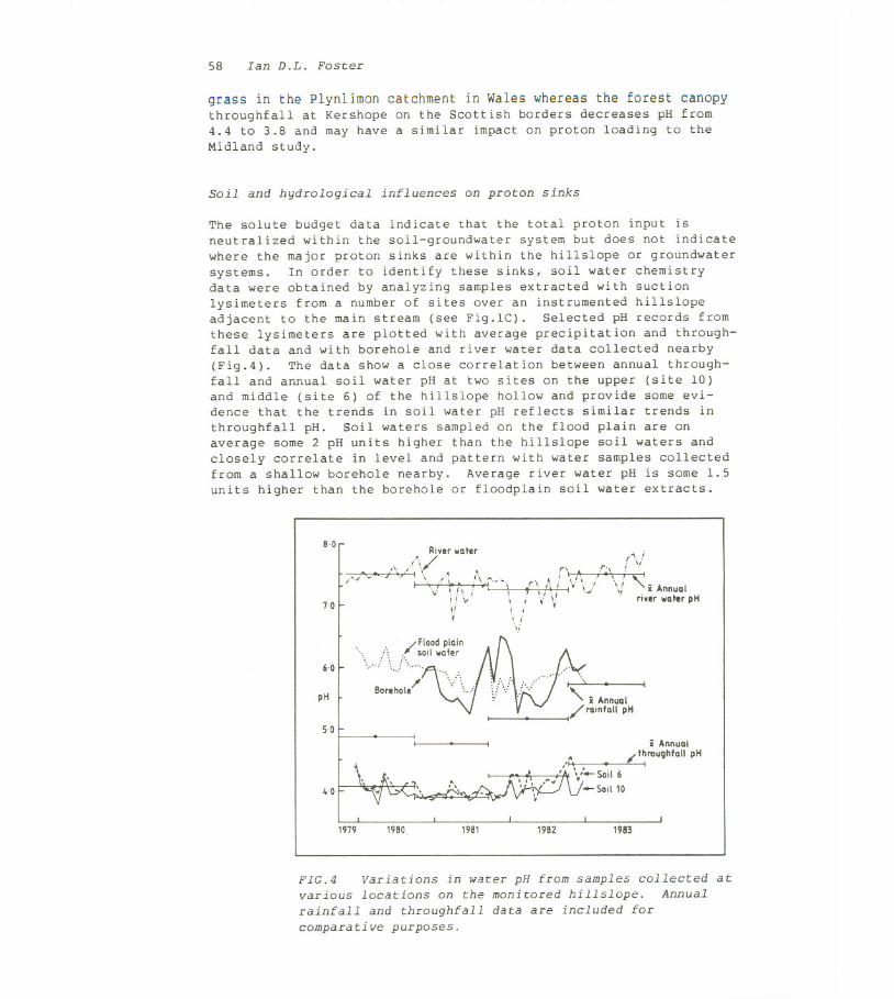
The solute budget data indicate that the total proton input isneutralized within the soil-groundwater system but does not indicatewhere the major proton sinks are within the hillslope or groundwatersystems. In order to identify these sinks, soil water chemistrydata were obtained by analyzing samples extracted with suctionlysimeters from a number of sites over an instrumented hillslopeadjacent to the main stream (see Fig.1C). Selected pH records fromthese lysimeters are plotted with average precipitation and through-fall data and with borehole and river water data collected nearby(Fig.4). The data show a close correlation between annual through-fall and annual soil water pH at two sites on the upper (site 10)and middle (site 6) of the hillslope hollow and provide some evi-dence that the trends in soil water pH reflects similar trends inthroughfall pH. Soil waters sampled on the flood plain are onaverage some 2 pH units higher than the hillslope soil waters andclosely correlate in level and pattern with water samples collectedfrom a shallow borehole nearby. Average river water pH is some 1.5units higher than the borehole or floodplain soil water extracts.
8,0
/,.,""v-
River "ater
. /,/
.~ \'v'/\'ii /\~-'\ (\;\ r'1-,jII V" i ii' i ii',. I
'i
.f", r\/
I','~. \/ i Annual
. riverwaterpH7,0
6,0
. :. /Flood plain
\ :i \../ ;~~~,:e::'.Borehole \': \,,:]
pH
5,0
4.0
i Annual
,~ . /t~roUghfallpH, , I" ..-Soil 6",-Soil 10
1979 1980, 1981 1982 1983
FIG.4 Variations in water pH from samples collected atvarious locations on the monitored hillslope. Annualrainfall and throughfall data are included forcomparative purposes.
Acid buffering in forested ecosystems 59
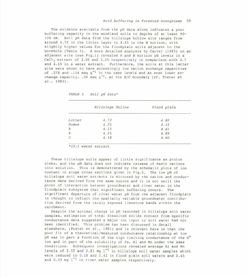
The evidence available from the pH data alone indicates a poorbuffering capacity in the woodland soils to depths of at least 90-100 cm. Soil pH data from the hillslope hollow site ranges fromaround 4.72 in the litter layer to 4.25 in the B horizon, withslightly higher values for the floodplain soils adjacent to theborehole (Table 3). A more detailed analysis by Carter (1985) on anadjacent site (see Fig.l) revealed A and B horizon pH levels in aCaC12 extract of 3.05 and 3.25 respectively in comparison with 3.7and 4.15 in a water extract. Furthermore, the soils at this latter
site were shown to have exceedingly low cation exchange capacitiesof .278 and .104 meq g-l in the same levels and an even lower ex-change capacity, .06 meq g-l, at the B/C boundary (cf. Foster etal., 1983).
TABLE 3 Soil pH data *
Hillslope Hollow Flood plain
4.804.334.414.894.60
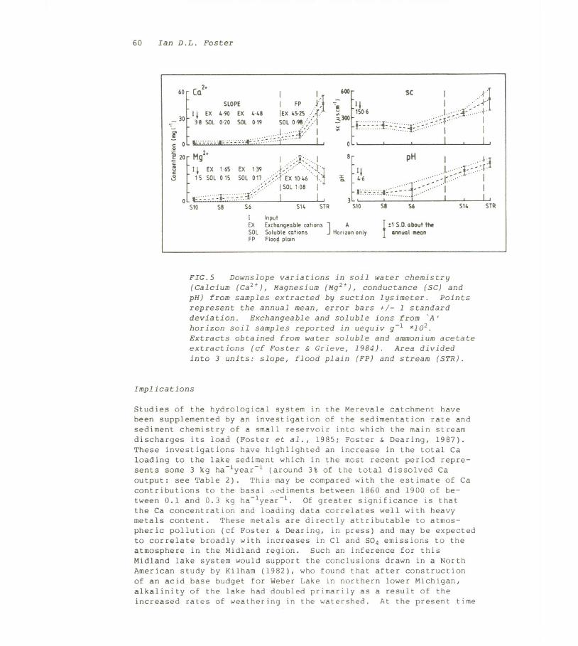
These hillslope soils appear of little significance as protonsinks, and the pH data does not indicate release of basic cationsinto solution. This is demonstrated by the schematic plots of ioncontent in slope cross sections given in Fig.5. The low pH ofhillslope soil water extracts is mirrored by the cation and conduc-tance data derived from the same source and it is not until thepoint of interaction between groundwater and river water in thefloodplain subsystem that significant buffering occurs. Thesignificant departure of river water pH from the adjacent floodplainis thought to reflect the spatially variable groundwater contribu-tion derived from the rarely exposed limestone bands within thecatchment.
Despite the minimal change in pH recorded in hillslope soil watersamples, estimation of total dissolved solids content from specificconductance data suggested a major ion input to soil water had notbeen identified. This problem has been discussed in detailelsewhere, (Foster et al., 1981) and is relevant here in that thepoor fit of a theoretical/measured conductance relationship at lowpH was in part a function of the high limiting conductance of the H+ion and in part of the solubility of Fe, Al and Mn under the sameconditions. Subsequent investigations revealed average Al and Mn
levels of 2.52 and 2.81 mg 1-1 in hillslopesoilwater samples whichwere reducedto 0.18 and 0.42 in floodplain soil watersand 0.45and 0.03 mg 1-1 in river water samples respectively.
Litter 4.72Humus 4.25A 4.15B 4.25C 4.38
*10:1 water extract
60 Ian D.L. Foster
60
[
(Q2+ I ISLOPE 1 FP J~I
I I EX HO EX H8 lEX ~5'25 :' .r.:30 : . .,- 38 SOL020 SOL019 SOL0'98:.::.:.:1-;. 1"""1':'-- IE ",,"";:---7.71:- I""""".,I,,,,,,,,,,,,,~':--:,:'"i''''' Ic 0 __-on .,," . ,0+: 2+~20
~
Mg 1>1<...1~ I I EX 165 EX 139 .f/"" "":'-1"
.3 15 SOL015 SOLo17:;/hx 1046"{.-!
0 F;; ;;;F:::::::::t;':;:'" . : SOL108 : ,510 58 56 514 5TR
I InputEX Exchangeablecations ] ASOL Soluble cations Hor,zononlyFP Floo~plain
-600
1
SC '.I~: i'Ii II I ..,>~:;: 1506 ..L,'~>l<..j.,3300 '''''''' ","~'>~.f~'" I
:;: I~~~.~~+.~..~.~.<+.7.~ " I I0 ' , . I. I ,8
~
pH I ..<f~III I."'~':..l.~.~.r
~ 46 . "",""~>r~."" IF~.~.~.:,~:.;.:::.:~"L-~,~"""I I
3 ,''''''''''0:''''' 1--'' I , I,510 58 S6 S14 STR
I !1 S.D.about the
I IIIInuaI mean
FIG.5 Downslope variations in soil water chemistry(Calcium (Ca2+),Magnesium (Mg2+), conductance (SC) andpH) from samples extracted by suction lysimeter. Pointsrepresent the annual mean, error bars +/- 1 standarddeviation. Exchangeable and soluble ions from 'A'horizon soil samples reported in uequiv g-l *102.Extracts obtained from water soluble and ammonium acetate
extractions (cf Foster & Grieve, 1984). Area dividedinto 3 units: slope, flood plain (FP) and stream (STR).
Implications
Studies of the hydrological system in the Merevale catchment havebeen supplemented by an investigation of the sedimentation rate andsediment chemistry of a small reservoir into which the main streamdischarges its load (Foster et al., 1985; Foster & Dearing, 1987).These investigations have highlighted an increase in the total Caloading to the lake sediment which in the most recent period repre-sents some 3 kg ha-lyear-l (around 3% of the total dissolved Caoutput: see Table 2). This may be compared with the estimate of Cacontributions to the basal sediments between 1860 and 1900 of be-
tween 0.1 and 0.3 kg ha-lyear-l. Of greater significance is thatthe Ca concentration and loading data correlates well with heavymetals content. These metals are directly attributable to atmos-pheric pollution (cf Foster & Dearing, in press) and may be expectedto correlate broadly with increases in Cl and S04 emissions to theatmosphere in the Midland region. Such an inference for thisMidland lake system would support the conclusions drawn in a NorthAmerican study by Kilham (1982), who found that after constructionof an acid base budget for Weber Lake in northern lower Michigan,alkalinity of the lake had doubled primarily as a result of theincreased rates of weathering in the watershed. At the present time
Acid buffering in forested ecosystems 61
the mechanism of increased Ca loading to the Merevale lake sediments
is being investigated.
CONCLUSIONS
A number of specific conclusions may be drawn from this investiga-tion of acid rain impacts in Midland England.
(a) Rainfall pH on average in a number of Midland sites is I to2 pH units lower than the level expected from CO2 equilibrium cal-culations.
(b) Rainfall acidity is highly variable, and is likely to re-flect local as well as regional sources.
(c) The dominant acid forming anions are sulphate and chloride
rather than nitrate.and sulphate which are identified as the mainacid associated ions in many European and North American studies.
(d) The presence of a mixed oak canopy depresses rainfall pH byaround one pH unit. This depression appears to be caused by theinterception of aerosols bearing sulphate rather than chloride ions.
(e) Proton loading above CO2 equalization from the input ofrainfall could increase weathering rates by around 5% if no othersignificant proton sinks exist. This may rise to 10% if the add-itional acidity due to throughfall is all associated with acidpollutants.
(f) Buffering capacity of the soils in this area is minimal, andsoil water reactions are dominated by the mobilization of toxicmetals into soil water solution.
(g) Buffering of river water is largely controlled by hydrologi-cal pathways especially in terms of groundwater interacting withlocal limestone outcrops in the catchment. It is most likely thatthe proton loading is associated with chemical weathering in thegroundwater zone rather than with organic proton sinks.
(h) Continuation of the increased proton loading (atmosphericdeposition) to the catchment may be the major cause of historicalincreases in Ca loading to the downstream reservoir as reflected inthe lake sediment chemical record.
The overall impact of this forest ecosystem appears to be a netenhancement of hydrogen ion input through aerosol interception.Soils in this area are base poor and are incapable of bufferingacidic inputs. Buffering only takes place in the groundwater systemin close proximity to calcareous deposits.
ACKNOWLEDGEMENTS I would like to thank Coventry City Council andNERC for funding for this research. The Environmental Health Officeof Coventry City Council made pH data freely available for analysis.Thanks are especially due to Dr John Dearing of Coventry Polytechnicfor casting a critical eye over the manuscript and to Dr AlanMartin, CEGB, Ratcliffe on Soar, Nottingham for lengthy discussionsconcerning the nature and type of CEGBemissions in the Midlandregion. I would also like to thank Shirley Addleton for preparingdiagrams to the usual high standard on such short notice.
62 Ian D.L. Foster
REFERENCES
Anon (1986) Acidity in United Kingdom Fresh Waters. Prepared forthe Dept. Env. by UK acid waters review group.
Bricker, D.P. (1986) Geochemical investigations of selected EasternUnited States watersheds affected by acid deposition. J. Geol.Soc. Lond. 143, 621-626.
BSI (1969) Methods for the measurement of air pollution Part 1.Deposit Gauges. British Standards Institution. Publ. 1747.
Carter, A.D. (1985) Solute pathways in a forested ecosystem: adrainage basin approach. Unpub. PhD Thesis, Coventry(Lanchester) Polytechnic.
Cogbill, C.V. & Likens, G.E. (1974) Acid precipitation in theNortheastern United States. Wat. Resour. Res. 10, 1133-1137.
Cresser, M.S., Edwards, A.C., Ingram, S., Skiba, U. & Peirson-Smith,T. (1986) Soil-acid deposition interactions and their possibleeffects in geochemical weathering rates in British uplands. J.Geol. Soc. Lond. 143, 649-658.
Dochinger, L.S. & Seliga, T.A. (eds) (1975) Proc. First Int. Symp.on Acid Precipitation and the Forest Ecosystem. N.E. Forest ExptSta., Upper Darby, PA.
Edmunds, W.M. & Coe, K. (1986) Geochemical aspects of acid rain. J.Geol. Soc. Lond. 143, 619-620.
Foster, I.D.L. (1979) Intra-catchment variability in solute re-sponse, an East Devon Example. Earth Surf. Proc. 4, 381-394.
Foster, I.D.L. (1980) Chemical yields in runoff, and denudation in asmall arable catchment, East Devon, UK. J. Hydrol. 47, 349-368.
Foster, I.D.L. & Dearing, J.A. (1987) Lake-catchments and environ-mental chemistry: a comparative study of contemporary and his-torical catchment processes in Midland England. Geo. Journal14(3), 285-297.
Foster, I.D.L. & Dearing, J.A. (in press) Quantification of longterm trends in atmospheric pollution and agricultural eutrophica-tion: a lake watershed approach. Proc. Vancouver IAHS Symposium,August 1987.
Foster, I.D.L. & Grieve, I.C. (1982) Short term fluctuations indissolved organic matter concentrations in streamflow draining aforested watershed and their relation to the catchment budget.Earth Surf. Proe. Landf. 7, 417-425.
Foster, I.D.L. & Grieve, I.C. (1984) Some implications of smallcatchment solute studies for geomorphological research. In:Field Experiments in Geomorphology (ed by T.P.Burt &D.E.Walling). Geo Books.
Foster, I.D.L., Carter, A.D. & Grieve, I.C. (1983) Biogeochemicalcontrols on river water quality in a forested drainage basin,Warwickshire, UK. Hyd. Sei. Pub. 141, 241-253.
Foster, I.D.L., Dearing, J.A., Charlesworth, S.M. & Kelly, L.A.(1987) Paired lake-catchment studies: a framework for investi-gating chemical fluxes in small drainage basins. Appl. Geog.7(2), 115-133.
Foster, I.D.L., Grieve,specific conductancetions. Hydrol. Sei.
I.C. & Christmas, A.D. (1981) The use ofin studies of natural waters and soil solu-
Bull. 26, 257-269.
Acid buffering in forested ecosystems 63
Garrels, R.M. & McKenzie, F.T. (1971) Evolution of the sedimentaryrocks. Harper and Row.
Granat, L. (1972) On the relation between pH and the chemical com-position in atmospheric precipitation. Tellus, 24, 550-560.
Hornung, M., Adamson, J.K., Reynolds, B. & Stevens, P.A. (1986)Influence of mineral weathering and catchment hydrology on drain-age water chemistry in three upland sites in England and Wales.J. Geol. Soc. Land. 143, 627-634.
Kilham, P. (1982) Acid precipitation: Its role in the alkalizationof a lake in Michigan. Limnol. Oceanogr. 27, 856-867.
Likens, G.E., Wright, R.F., Galloway, J.N. & Thomas, J.B. (1979)Acid Rain. Scient. Amer. 241(4) 39-47.
Likens, G.E., Bormann, F.H., Pierce, R.R., Eaton, J.S. & Johnson,N.M. (1977) Biogeochemistry of a forested ecosystem. Springer-Verlag.
Martin, A. (1979) A survey of the acidity of rainwater over largeareas of Great Britain. Sci. Tot. Environ. 13, 119-130.
Miller, H.G. (1984) Deposition-plant-soil interactions. Phil.Trans. Roy. Soc. B305, 339-352.
Reid, J.M., Macleod, D.A. & Cresse~, M.S. (1981) The assessment ofchemical weathering in north-east Scotland. Earth Surf. Proc. 6,447-457.
Rose, C. (1985) Acid rain falls on British Woodlands. New Sci. 14Nov., 52-57.
Sm ith, W. H. (ed) (1981)
Van Breemen, N., Mulder,and alkalinization of
Whitfield, W.A. & Beard,survey record No. 66.Harpendon.
Williams, A.G.,the chemicalProc. Landf.
Air Pollution and Forests. Springer-Verlag.J. & Driscoll, C.T. (1983) Acidificationsoils. Plant and Soil 75, 283-308.G.A. (1980) Soils in Warwickshire IV. SoilSoil Survey of England and Wales,
Ternan, L. & Kent, M. (1986) Some observations on
weathering of the Dartmoor granite. Earth Surf.11, 557-574.


![implications of a potential range expansion of invasive ... · Implications of a potential range expansion of invasive earthworms in Ontario’s forested ecosystems [electronic resource]](https://img.pdfslide.net/doc/110x75/5f8559084b8f5652f4182685/implications-of-a-potential-range-expansion-of-invasive-implications-of-a-potential.jpg)